1. Kala Nera Milies Kala Nera
|
|
|
- Edward Warren
- 5 years ago
- Views:
Transcription
.")
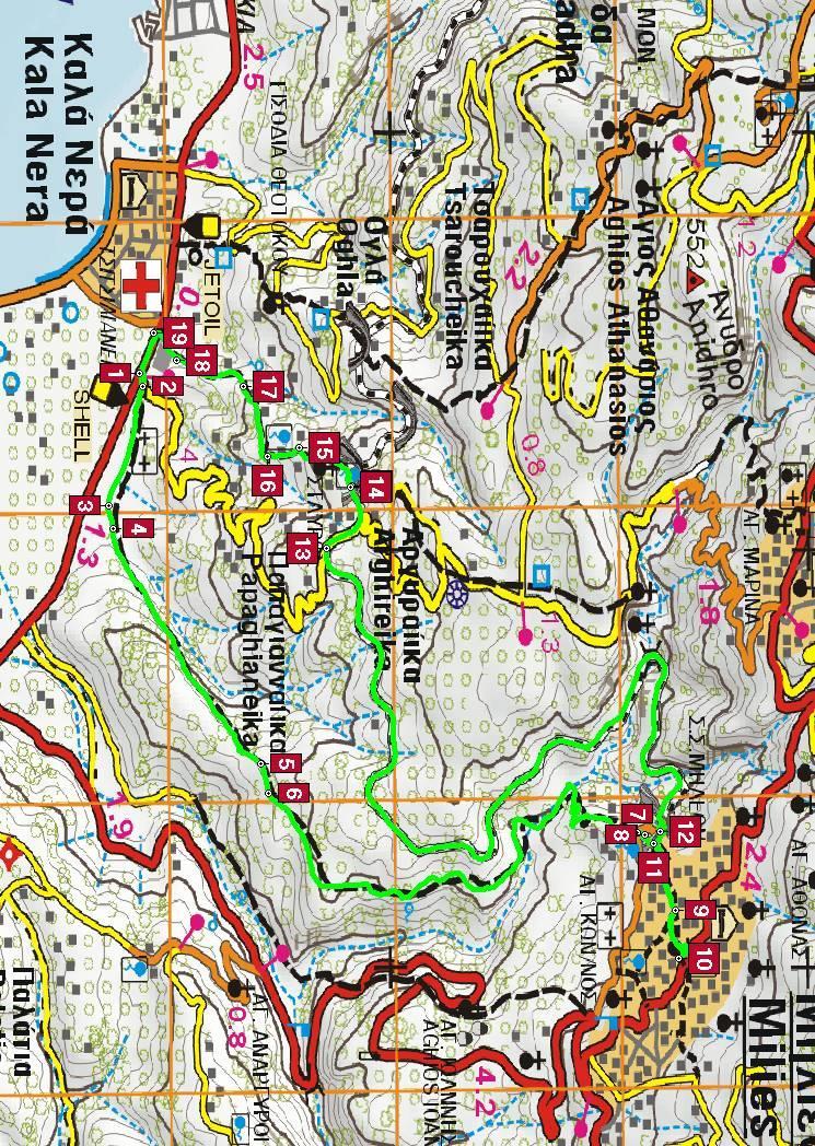
1 1. Kala Nera Milies Kala Nera A beautiful and varied walk from Kala Nera, a tourist seaside village, to Milies which lies 400 metres higher up. From there it proceeds back down to Kala Nera along another route. The route partly follows an existing marked walk along old cobbled paths (kalderimi). You cross a stream with lush vegetation and you may be fortunate enough to hear birdsong including that of nightingales. There are many flowers along the route. The descent to the coast mainly follows the railway track along which in former times produce from mountain villages was transported to Volos. Nowadays there is a tourist service on the historic train. Just outside Milies on the way down you have to cross a high metal railway bridge, which can pose a problem for those with a fear of heights. The walk is 12 kilometres long and spans a height of 375 metres. It took us 2.75 hours. Start: To get to Kala Nera there are many buses every day from Volos to or through Kala Nera. Map: Anavasi 6.21 Thessaly, Mt Pilion, 1: The walk partly overlaps walks 8 and 9 on the map. Map for waypoints and tracks: Anavasi Topomap 3D on CD-ROM, Pilio Mavrovouni, South Pilio, Food and drink: In Kala Nera and the square in Milies. Milies has various spring water drinking fountains. 1. The walk begins opposite the health centre in Kala Nera, a light yellow building on the main road just past the Ka Oil petrol station if you are driving in the direction of Volos. A narrow road with a walker sign (yellow plate with a black walker) marks the beginning of the walk. 2. Turn right after 50 metres. A metal sign indicates Milies in Greek letters (ΜΗΛΙΕΣ). Beyond the graveyard on your left the concrete path changes into a cobbled path, which continues for some distance before becoming an earth path. 3. After 400 metres, at a fork, you bear left into an olive grove.

2 4. After 50 metres you reach a crossing. Straight ahead is a kalderimi. This climbs steadily, almost in a straight line. On both sides of the kalderimi are olive trees. Follow this kalderimi for slightly more than a kilometre. You will see red dots at regular intervals. Ignore a path to the right. 5. The kalderimi ends at an earth path, near a house (under construction, June 2007). Turn to the right here. The path descends slightly. 6. After 100 metres take a narrow kalderimi to the left. A red dot marks the route. The path reaches a broader stone path; continue straight ahead. Soon after the first views of Milies the kalderimi narrows and starts to wind more. Gradually the olive groves give way to different vegetation with other trees and shrubs. Ignore all side paths on this stretch. You pass a sign towards a cave, 100 metres further along a sidepath. You cross a stream over a concrete bridge. From here the kalderimi winds upwards towards Milies. After a few bends you reach the first houses. Follow the kalderimi into the village. 7. Cross an asphalt road and follow the kalderimi upwards. 8. After 30 metres turn up to the right. Ignore side paths and follow the kalderimi upwards. 9. You arrive at a small bridge on your right which leads to the centre of the village. A small wooden sign showing a table and chairs points in that direction. Turn right here and walk to the central square. 10. From the square return along the same kalderimi between the houses down to the bridge. The train on the small wooden sign indicates the direction down to the station. Walk in that direction. 11. Before a fence at a church with cypress trees a kalderimi descends to the right towards the station. 12. At the bottom of the kalderimi turn right onto the asphalt road. Walk past the station and then follow the railway track past a picnic area along the stream. You now follow the railway track over a distance of 4 kilometres. At the beginning the route crosses a metal bridge and then gradually descends in the direction of the coast. Just past the metal bridge there is a narrow path to the right at a flat stone with ΑΓ. ΤΑΞΙΑΡΧΕΣ and ΒΥΖΙΤΣA


3 written in red letters. If you like you can climb up this path to a small church set against the rocks above. The church is closed but the path up there is spectacular. The walk continues along the railway track. After some time olive trees predominate once again on both sides of the track. You will have some lovely views over the Pagasitic Gulf. The railway track passes under an arched stone bridge. 13. A bit further down the railway track meets an earth road that runs along the track for a short while. Follow the track. 14. Just before a second arched stone bridge, at a bend in the railway track, turn left onto a wide path. Immediately turn right onto a narrow path. At a spring water drinking fountain the path joins a kalderimi. This kalderimi comes from the right, from the bridge. We follow this kalderimi down to the left. The descent now becomes a bit steeper and continues between olive trees and detached houses.

4 15. After 300 metres turn left onto another kalderimi. Red arrows indicate the route. 16. The kalderimi meets another kalderimi. Turn right. Here red dots also indicate the direction. 17. The kalderimi meets an earth road. Cross this road slightly diagonally to the right onto an ill defined path which soon becomes a kalderimi again. Follow this downwards. 18. The kalderimi ends abruptly between the olive trees. Continue walking straight ahead in the same direction as the kalderimi, and descend to the main road on a narrow path. 19. At the road turn left towards the starting point. Enjoyed your walk? Any comments? Let us know! info@pilionwalks.com
5
HARDMOORS 26.2 WHITE HORSE HALF ROUTE DESCRIPTION - 018
 HARDMOORS 26.2 WHITE HORSE HALF ROUTE DESCRIPTION - 018 Follow Cleveland Way, keeping to the left hand path (right path is a bike trail) Ignoring any turnings to the left or right At path junction (after
Waterhead Pier to Orrest Head, Windermere and Bowness
 Waterhead Pier to Orrest Head, Windermere and Bowness A 4 1 2 hour walk through Woodlands and the Troutbeck Valley with spectacular Lake and Mountain views and a lakeshore path. Walk 10 Walk 11 Walk 12
Follow the road to Figueira and once there turn left at the road junction. 30 Minutes
 Follow the road to Figueira and once there turn left at the road junction. 30 Minutes Continue along this road, before the bridge turn right into Largo 1 st Maio and keeping left turn into Rua do Meia
Danbury Words and pictures by Laurie Page of the Public Rights of Way team at Essex County Council.
 Danbury Words and pictures by Laurie Page of the Public Rights of Way team at Essex County Council. An undulating walk from Danbury village to the bluebells at the National Trust property of Blakes Wood.
Welsh Newton and Woodland
 Welsh Newton and Woodland This is a 8.2km miles (approx) walk which will take about 2.5 hours at a relaxed and leisurely pace. There are a few hills but no steep inclines. Start at Llangrove bus stop and
ST. AGNES. you cannot put a time limit on beauty.
 ST. AGNES CIRCULAR WALKS AROUND There are many enjoyable and picturesque walks around St. Agnes most are signposted and are featured on the St. Agnes Mini-guide map. Because most of our footpaths are in
Tideswell to Castleton
 Tideswell to Castleton 1 Walk summary Length: 14 km, 8.5 miles Maps: OS Explorer OL1 The Peak District - Dark Peak Area, OS Explorer OL24 The Peak District - White Peak Area, OS Landranger 110 Sheffield
Beautiful Walks from the Blue Ball Inn
 Walk No. 7 COAST AND VALLEY WALK Countisbury, Glenthorne, County Gate, Brendon, Rockford and Wilsham 10 MILES APPROX. Walking time 5 hours approx. (not including breaks)> OS Sheet 64/74 Lynton and Lynmouth.
Bakewell Club Site - Robin Hood's Stride
 Bakewell Club Site - Robin Hood's Stride Camping and Caravanning Route Summary A circular walk with fabulous views winding it's way through the beautiful White Peak scenery. Points of interest include
The Mendip Way. Route Directions and Maps Wells to Frome
 The Mendip Way Route Directions and Maps Wells to Frome Website: www.mendiphillsaonb.org.uk Email: mendip@mendiphillsaonb.org.uk Facebook & Twitter: @MendipHillsAONB Phone: 01761462338 1 Wells to Shepton
COSTA BLANCA MOUNTAIN WALKERS - WALK DESCRIPTION. Visit for more walks descriptions in Spain
 COSTA BLANCA MOUNTAIN WALKERS - WALK DESCRIPTION Visit www.walksinspain.org for more walks descriptions in Spain Walk description originally prepared by:- Ralph Phipps Last Updated 18 th April 2015 Title
Waterfall to Heathcote
 Waterfall to Heathcote 5 hrs Hard track 10.8 km One way 4 467m This walk explores the heart of Heathcote National Park, and is easily accessed with a train station at either end. Although relatively close
This walk description is from happyhiker.co.uk
 This walk description is from happyhiker.co.uk Pendle Hill Walk From Barley Starting point and OS Grid reference Ordnance Survey map Distance Traffic light rating Barley village honesty box car park OS
Rhossili - Tears Point - Mewslade Bay - Talgarth's Well - Rhossili - ID: 148. Walk description:
 Walk description: A glorious walk combining thrilling cliffs with beautiful wild beaches and a bird's-eye view of the Gower peninsula from Rhossili Down. The adventurous can walk out to the Worm's Head
Husthwaite to Byland Abbey
 Husthwaite to Byland Abbey This walk begins with a loop round the village of Husthwaite and continues towards Coxwold along a disused railway line, which is now a right of way. It passes through Coxwold
Route: Skewsby Foulrice Stearsby
 Route: Skewsby Foulrice Stearsby Distance: 7 miles Map: Explorer: 300 Howardian Hills & Malton Start (OS ref): SE625710 Park in the village of Skewsby. Walk east out of the village to the T-Junction and
Echo Point to Leura Forest via Three Sisters and Giant Stairs loop
 Echo Point to Leura Forest via Three Sisters and Giant Stairs loop 3 hrs 3.8 km Circuit Hard track 512m This walk starts from the popular Echo Point, in Katoomba, and winds down to the base of the Three
10 Miles Circular 5 hours
 VISIT RYEDALE PICKERING AND CAWTHORN CAMPS 10 Miles Circular 5 hours Moderate Terrain 120616 A 10 mile (16km) there and back walk from the market town of Pickering in Ryedale. The route heads north through
NEWLANDS CORNER AND ST MARTHAS
 NEWLANDS CORNER AND ST MARTHAS 10k CIRCULAR ROUTE 2½-3HRS GU4 8SE From Newlands Corner on the North Downs just outside Guildford, you can enjoy one of the most beautiful panoramas of quintessential English
Currie Rd to Davidson Park
 Currie Rd to Davidson Park 3 hrs 7.2 km One way Moderate track 28m Starting at Currie Rd in Forestville, this walk follows Middle Harbour to Davidson Park, under Roseville Bridge. There are two optional
Walk NOC 03 Location: Llyn y Fan (the lake) and Fan Brycheinog (the mountain) off Trecastle Road
 and Fan Brycheinog (the mountain) off Trecastle Road") 8 Walk NOC 03 Location: Llyn y Fan (the lake) and Fan Brycheinog (the mountain) off Trecastle Road Directions: Distance (miles): Time (hours): Length of Walk: Turn right out of the castle, take first left
8 Walk NOC 03 Location: Llyn y Fan (the lake) and Fan Brycheinog (the mountain) off Trecastle Road Directions: Distance (miles): Time (hours): Length of Walk: Turn right out of the castle, take first left
9.5 km Circular 3 hours
 SILENT POOL AND ST MARTHA S HILL Challenging Terrain A 9.5km (6 mile) circular walk in the Surrey Hills, visiting a number of popular attractions including Silent Pool, a stretch of the North Downs Way,
A Walk around Holmes Chapel starting & finishing at Holmes Chapel Railway Station. by Tony & Lindsay Wright (2016)
") A Walk around Holmes Chapel starting & finishing at Holmes Chapel Railway Station. by Tony & Lindsay Wright (2016) Introduction Holmes Chapel Railway Station is on the Crewe to Manchester line. The station
A Walk around Holmes Chapel starting & finishing at Holmes Chapel Railway Station. by Tony & Lindsay Wright (2016) Introduction Holmes Chapel Railway Station is on the Crewe to Manchester line. The station
THE PONTON PLOD - 27 MILE ROUTE
 THE PONTON PLOD - 27 MILE ROUTE Emergency Phone Number 07771 813514 Abbreviations: BW Bridleway X Cross immd immediately FP Footpath TL Turn left L Left thro through KG Kissing Gate TR Turn right R Right
RILLINGTON TO MALTON by Tania Dickinson
 RILLINGTON TO MALTON by Tania Dickinson This walk takes you from the Vale of Pickering up on to the Wold scarp, before dropping down again through the pretty village of Settrington and joining the Centenary
Masson Hill. Walk. Approximately 4 km. Moderate Walk Begins from Matlock Railway Station
 Masson Hill Walk Approximately 4 km Moderate Walk Begins from Matlock Railway Station TOWN WALKS Masson Hill walk is approx. 4 km. It can be walked in a couple of hours or so. Enjoy your walk and the beautiful
Hammer Vale and Linchmere Common
 point your feet on a new path Hammer Vale and Linchmere Common Distance: 9 km=5½ miles or 6 km=3¾ miles easy walking with one steep section Region: Hampshire, West Sussex Author: Botafuego Refreshments:
Katoomba Falls Circuit
 Katoomba Falls Circuit hr 5 mins.5 km Circuit Hard track 59m For those looking for a walk involving more than simple boardwalk, this trail winding through the temperate rain forest could be just the thing.
The North Pennines from near Langwathby
 3.6 Langwathby to Armathwaite Map panel?? Distance 12.7 miles (20.5 km) Terrain farm, woodland and riverside paths; some potentially muddy tracks; a few short sections of road Grade gently undulating Food
9.5 km Circular 3 hours
 MEDIEVAL WAVERLEY Challenging Terrain A 6 mile (9.5km) undulating circular walk from Tilford village passing close to The Sands village and the historic ruins of Waverley Abbey. From the top of Crooksbury
THE WELLDIGGERS ARMS, HESWORTH AND FITTLEWORTH TRAIL
 THE WELLDIGGERS ARMS, HESWORTH AND FITTLEWORTH TRAIL 5.5 miles Circular 3 hours 041017 Challenging Terrain A 300-year-old pub turned country-inn on the edge of the South Downs National Park, The Welldiggers
Thornton le Dale Walks
 Thornton le Dale Walks A collection of circular walks in, and around, the village www.visitthorntonledale.co.uk Thornton-le-Dale Traders Forum and Thornton le Dale Parish Council 1 Thornton le Dale Circular
Slindon Folly - South Downs, West Sussex
 Slindon Folly - South Downs, West Sussex Starts at Park road-side near entrance to Slindon College 2 hours 15 minutes 4.5miles 7.2km Easy ID: 0.1598 Developed by: Chris Mumford Checked by: Rockpit www.ramblersroutes.org
A mainly flat walk along the Peak Forest Canal to Castle Hill and returning along the River Tame via Hulmes Wood and Haughton Dale.
 Walk 9 Haughton Green, Peak Forest Canal, Castle Hill, Hulmes Wood, River Tame, Haughton Dale Circular Miles: 3.9 Time: 1 Hour 30 Minutes Grade: Easy To Moderate Starting Point: Junction Of Gibraltar Lane/Newport
Thornton le Dale Walks
 Thornton le Dale Walks A collection of walks in and around the village Thornton le Dale Traders Forum www.visitthorntonledale.co.uk Thornton le Dale Walks Walk 1: Beck Isle Cottage and All Saints Church
Approximate distance: 5.5 miles For this walk we ve included OS grid references should you wish to use them. Start. End
 Approximate distance: 5.5 miles For this walk we ve included OS grid references should you wish to use them. End 4 1 Start 3 2 N W E S Reproduced by permission of Ordnance Survey on behalf of HMSO. Crown
THE DOG AND DUCK HAREWOODS ESTATE TRAIL. 6 Miles Circular 3 hours. Getting there. Walk Sections
 THE DOG AND DUCK HAREWOODS ESTATE TRAIL Moderate Terrain A 6 mile circular pub walk from the Dog and Duck in Outwood, Surrey. The Dog and Duck is a delightful pub where everyone is made welcome. From walkers
Dyrham and Hinton Parish Walks
 Dyrham and Hinton Parish Walks A series of five walks in the parish, exploring most of the public footpaths. By John Miller Each walk is described in detail, with a complete map, to provide a handy guide
Walk 7: Watchet to washford
 Walk 7: Watchet to washford Length: Moderate - 7.5 miles / 12 km Good For: Theme: History Duration: 2-3 hours depending on speed of walking Notes: This is a moderate to difficult walk in places, with steps,
LOCAL CIRCUIT EM1: EAST MALLING & BARMING HEATH. N 2m ROADS: Significant roads PATHS: Starting direction Barming Longsole Mission Church
 Ditton Church Scott Close LOCAL CIRCUIT EM1: EAST MALLING & BARMING HEATH 6 Community Centre F Open fields (see 'Introductory Notes') 1m 88 Direction label (as in the walk notes) East Malling Church -
Approximate distance: 10 miles For this walk we ve included OS grid references should you wish to use them. Start. End
 Approximate distance: 10 miles For this walk we ve included OS grid references should you wish to use them. 2 3 Start End 1 N W E S Reproduced by permission of Ordnance Survey on behalf of HMSO. Crown
BALCOMBE AND ARDINGLY RESERVOIR, WEST SUSSEX
 BALCOMBE AND ARDINGLY RESERVOIR, WEST SUSSEX 7 miles Circular 4 hours 080816 Challenging Terrain Hi, I'm Luke and this is my West Sussex Weekends walk It's a 7 mile loop from Balcombe rail station, taking
How to get there. Respect - Protect - Enjoy
 How to get there Driving: Postcode is RG9 5PF and there is a car park just across from the pub. Nearest station: Henley-on-Thames station is 5.6 miles away. We re delighted to present three circular walks
Winterfold Wood. point your feet on a new path. In Brief
 point your feet on a new path Winterfold Wood Distance: 8½ km=5¼ miles Region: Surrey Author: Schwebefuss Refreshments: Windmill Inn, Peaslake after the walk moderate walking with many gradients Date written:
Walking Pembrokeshire.
 Walking Pembrokeshire Canaston Woods Walk It s good to walk, so why not step out and sample some of the walks your neighbourhood has to offer. This pleasant and interesting walk which starts and finishes
Cleeve Common Self-Guided Walk 1 Family Circular
 Cleeve Common Self-Guided Walk 1 Family Circular Start point: Quarry Car Park Nearest postcode: GL52 3PW please note this is for the golf club. To find the quarry car park drive past the golf club car
NETTLESTEAD & YALDING
 NETTLESTEAD & YALDING ULL CIRCUIT - Sheet 1 (first and last sections) Open fields (see 'Introductory Notes') 88 Direction label (as in the walk notes) ROADS: 81 10m Significant roads Redhill arm North
Carrington Park to Leura Forest and pass loop
 Carrington Park to Leura Forest and pass loop 3 hrs Hard track 4.8 km Circuit 4 674m This walk is a fantastic way to see Leura Forest. The walk descends from Carrington Park, visiting Leura Forest and
Walk 2 Village Hall - The Shippy - Woodhouse Farm - Village Hall
 Walk 2 Village Hall - The Shippy - Woodhouse Farm - Village Hall The walk is approximately 4km (2.5 miles) across fairly flat countryside with about a quarter on country lanes. It should take about 1 hour
Walk Description. Directions
 Title: Saffron Trail: Battlesbridge to Chelmsford Distance: 14¾ miles Time taken: 6 hours Start Point: Outside the Barge Inn, Battlesbridge OS Explorer Map: 175 & 183 Grid Ref.: TQ 780 947 Transport: Rail:-
WONDERLAB: THE EQUINOR GALLERY. The science and maths behind the exhibits 30 MIN INFORMATION. Topic FORCES. Age
 WONDERLAB: THE EQUINOR GALLERY and maths s INFORMATION Age 7 11 11 14 Topic FORCES 30 MIN Location LEVEL 3, SCIENCE MUSEUM, LONDON What s the science? What more will you wonder? and maths s Wonderlab:
VELINDRE VALLEYS WALK FOR STEFFAN
 VELINDRE VALLEYS WALK FOR STEFFAN IMPORTANT INFORMATION FOR WALKERS AND MARSHALS 1 Table of Contents Key Contact Numbers:... 3 Timetable and locations... 4 T-shirts... 4 Important Advice for Walkers...
Tenerife Sur: Short Walks Under 10 km. Santiago del Teide Almond Blossom
 Tenerife Sur: Short Walks Under 10 km Santiago del Teide Almond Blossom Route Summary This delightful circular walk is especially beautiful when the almond trees are in flower during January and February
Cilgerran Wildlife Park Circular Walk
 Walking embrokeshire Cilgerran Wildlife ark Circular Walk It s good to walk, so why not step out and sample some of the walks your neighbourhood has to offer. This pleasant and interesting walk which starts
8 Miles Circular 4 hours
 VISIT RYEDALE HELMSLEY AND RICCAL DALE 8 Miles Circular 4 hours 090616 Challenging Terrain An 8 mile (13km) circular walk from the market town of Helmsley in Ryedale. The route heads out across sheep pastures
GENERAL INFORMATION PLEASE FOLLOW THE COUNTRYSIDE CODE:
 KNIGHTON CIRCULAR WALKS The East Radnor Group of the Ramblers Association invites you to enjoy these walks around Knighton. Knighton is an excellent centre for walks in the lovely unspoilt mid-wales countryside
Stokenchurch. Bluebell Woods, Bomber Memorial, Red Kites, Getty s Cricket Ground, Nature Reserve
 Stokenchurch Bluebell Woods, Bomber Memorial, Red Kites, Getty s Cricket Ground, Nature Reserve Bomber Memorial The best time to visit Cowleaze Wood is in the spring when there is a memorable display of
Follow the Lantern Way clockwise from Dursley Town Hall through Cam & Coaley to Uley and back to Dursley (about 14 miles)
") According to the Rev Kilvert's diary of 1873, couples on their way to evening services in winter followed a practical though unusual local tradition: "My Mother says that at Dursley, when ladies and gentlemen
According to the Rev Kilvert's diary of 1873, couples on their way to evening services in winter followed a practical though unusual local tradition: "My Mother says that at Dursley, when ladies and gentlemen
9.5 km Circular 3 hours
 RANMORE CIRCULAR A 6 mile (9.5km) circular walk from Boxhill and Westhumble Station in the village of Westhumble, passing through part of the Polesden Lacey Estate, Ranmore Common and Denbies Vineyard.
Distance: 14 km=8½ miles or 7 km=4½ miles easy-to-moderate walking
 point your feet on a new path Normandy Distance: 14 km=8½ miles or 7 km=4½ miles easy-to-moderate walking Region: Surrey Author: Botafuego Refreshments: Pirbright, Ash date written: 20-feb-2012 date revised:
Shepherdswell - Dover
 Shepherdswell - Dover The North Downs Way > Shepherdswell to Dover Introduction This part of the path is slightly different in character from most other parts of the path since it spends much of the time
Maps The maps provided are a guide and are not to scale. Please use OS Explorer Map 120 (Chichester).
.") A Walker s Guide - Chichester Harbour Useful Information Directions All the walks were tested in 2013. Please note, however, that some footpaths may be diverted and buildings such as pubs may have changed
A Walker s Guide - Chichester Harbour Useful Information Directions All the walks were tested in 2013. Please note, however, that some footpaths may be diverted and buildings such as pubs may have changed
Hornsby Blue Gum Walk
 Hornsby Blue Gum Walk 3 hrs Hard track 6.7 km Circuit 4 374m This delightful loop is one of the prettiest and most popular walks in the Hornsby area. Going from an environment of ferns and clear bushland
EAST GRINSTEAD AND THE HIGH WEALD, WEST SUSSEX
 EAST GRINSTEAD AND THE HIGH WEALD, WEST SUSSEX 7 miles Circular 3.5 hours 301015 Challenging Terrain Hi, I'm Tom and this is my West Sussex Weekends walk. I live and work in London but often head out of
Heathcote to Engadine via Audley
 Heathcote to Engadine via Audley 6 hrs 3 mins 5 km One way Hard track 4 635m Covering a large section of central Royal National Park, this walk goes through the heath and scrub along a well managed and
Chichester Harbour. A Walker s Guide
 A Walker s Guide - Chichester Harbour Chichester Harbour A Walker s Guide Chichester Harbour is an Area of Outstanding Natural Beauty on the south coast of Britain. Virtually flat with far reaching sea
LDWA SOUTH DOWNS MARATHON
 AHD ahead SDW South Downs Way BL/BR bear left/bear right TL/TR turn left/turn right SP signpost/fingerpost X cross LEG 1 - EAST DEAN to WP1 NORTON GR 470019. Open 1030 to 1300. 9.6 miles. 1.1 From village
Greenwood. Walks. Cossall Canal Walk. Cossall Canal Walk
 Cossall Canal Walk C5 Cossall Canal Walk C5 Features: Cossall is a picturesque, relatively unspoiled village on the Nottingham canal, four miles south-east of Eastwood. Architecturally interesting. See
Under and Over Cliff Walk
 Under and Over Cliff Walk 4 hrs 9.4 km Circuit Moderate track 576m This walk from Wentworth Falls Station is a fantastic way to see a large majority of the Wentworth Falls cliffline. The track winds under
Callicoma Loop. 174m. 98m. 2 hrs. Hard track 5.1 km Circuit. 153m
 Callicoma Loop 2 hrs Hard track 5.1 km Circuit 153m This great circuit walk passes through some really nice forest around the fringe of Cherrybrook. Highlights of the walk include some beautiful rock overhangs
Hascombe and Winkworth Arboretum Downs Link Path, Smithbrook Kilns
 point your feet on a new path Hascombe and Winkworth Arboretum Downs Link Path, Smithbrook Kilns Distance: 18 km=11 miles Region: Surrey Author: RDC easy walking Date written: 7-may-2016 Last update: 30-aug-2018
Stage 5 Overview. 5 miles: Out of cricket club, follow path under A413 (by stream MIND YOUR HEAD!), and onto Old Amersham Rd
, and onto Old Amersham Rd") Stage 5 Overview Start time: 12:53 Saturday Distance: 13.5 miles Emergency: 07966 542315 Start: From Common Road, left to path then join Cockpit Road, then over BUSY ROAD to Heath End Road. 2 miles: off
Stage 5 Overview Start time: 12:53 Saturday Distance: 13.5 miles Emergency: 07966 542315 Start: From Common Road, left to path then join Cockpit Road, then over BUSY ROAD to Heath End Road. 2 miles: off
The Hundred Parishes
 The Hundred Parishes Walks from railway stations number 9 6.4 miles (10kms) from Bishop s Stortford to Stansted Mountfitchet Start: Bishop s Stortford station (Grid Reference TL492209) (ample parking and
THE BECK STONE Backstone Beck on Ilkley Moor
 THE BECK STONE Backstone Beck on Ilkley Moor 1 Three different routes which take in the best of the lower slopes of Ilkley Moor, with bracken, heather, a tarn (a small mountain lake) and rushing streams.
YHA RAVENSTOR Ideas for walks in the local area
 YHA RAVENSTOR Ideas for walks in the local area How to use this book This book contains some suggestions for enjoyable walks in the countryside immediately surrounding YHA Ravenstor. We hope that our guests
Redesdale Arms. A Trio of Walks
 Redesdale Arms A Trio of Walks Welcome to The Redesdale Arms Hotel The award winning 34 bedroom Redesdale Arms Hotel sits at the gateway to the Cotswolds in the High Street of the historic town of Moreton-in-Marsh.
LDWA SOUTH DOWNS MARATHON 13 th MAY 2018
 AHD ahead SDW South Downs Way BL/BR bear left/bear right TL/TR turn left/turn right X cross LEG 1 - EAST DEAN to WP1 NORTON GR 470019. Open 1030 to 1300. 9.7 miles. 1.1 From village hall TL and walk to
Walk Description. Directions
 Title: East Hanningfield Distance: 8 miles / 9 miles Time taken: 3-3½ hours Location: 5 miles south east of Chelmsford Parking: Free car park off The Tye, East Hanningfield, next to the primary school
Lincolnshire Walks. Ancaster. Three cir cular walks of2 3/4,4or 6km (11/3, 21/2 or 33/4 miles)
") Lincolnshire Walks Ancaster Three cir cular walks of2 3/4,4or 6km (11/3, 21/2 or 33/4 miles) Introduction These walks are set in the attractive countryside around the historic town of Ancaster. The town
Lincolnshire Walks Ancaster Three cir cular walks of2 3/4,4or 6km (11/3, 21/2 or 33/4 miles) Introduction These walks are set in the attractive countryside around the historic town of Ancaster. The town
There are toilets at Manningtree Station, Flatford (close to the hump back bridge) and in Dedham.
 and in Dedham.") Arriving by Train Main Features of the Walk Outline Route Employs particularly attractive paths, many of which offer impressive views across Dedham Vale. Includes a section along the tidal section of the
Arriving by Train Main Features of the Walk Outline Route Employs particularly attractive paths, many of which offer impressive views across Dedham Vale. Includes a section along the tidal section of the
Bagshot Heath and Swinley Forest
 point your feet on a new path Bagshot Heath and Swinley Forest Distance: 13 km=8 miles Region: Berkshire, Surrey Author: Botafuego Refreshments: Forest Look Out, Bagshot easy walking Date written: 17-feb-2013
Fernhurst and the Temple of the Winds
 point your feet on a new path Fernhurst and the Temple of the Winds Distance: 8 km=5 miles Region: West Sussex Author: Hautboy Refreshments: Fernhurst moderate walking Date written: 12-sep-2012 Last update:
Oldbury & Littleton, South Gloucestershire
 Oldbury & Littleton, South Gloucestershire Starts at Church Lane, Oldbury. BS35 1QF 2 hours 0 minutes 5.2miles 8.4km Easy ID: 0.2468 Developed by: GEOFF MULLETT Checked by: Marion Stone www.ramblersroutes.org
Bonnie Prince Charlie Walk
 Bonnie Prince Charlie Walk A waymarked route from Ashbourne to Derby to celebrate the 60th anniversary (1995) of the formation of the Ramblers' Association. This route follows the general direction of
FB01 - THE VIA FRANCIGENA ROAD BY BIKE - LEG I
 FB01 - THE VIA FRANCIGENA ROAD BY BIKE - LEG I Start node info End node info Total length Category Suggested type of bycicle Cycle time Uphill Downhill Max height Difficulty by cycle Coated Offroad Mountain
Tuskendammen - Oenkerk
 MAP 44 6,1 KM Tuskendammen - Oenkerk Follow the street. At the next intersection, go straight onto Klaas Douwesweg. Take the first forest path on the right, pass through cycle barriers. At the intersection,
Dorridge & District Residents Association A Walk Along The Green Belt From Dorridge to Catherine-de-Barnes
 Dorridge & District Residents Association A Walk Along The Green Belt From Dorridge to Carine-de-Barnes The starting section of this walk through open fields would be destroyed by building of motorway
Wattamolla to Big Marley Beach
 Wattamolla to Big Marley Beach 4 hrs 10.4 km Circuit Moderate track 4m This walk is an excellent loop which takes in both the coast and the heathy inland of Royal National Park. Nearly the whole walk has
Loch Ness Shores Club Site
 Loch Ness Shores Club Site Camping and Caravanning Falls of Foyers Route Summary A strenuous walk from Loch Ness Shores Club Site. The route climbs through forest to The Upper Foyers Waterfall and then
Walk 2: Beamsley Beacon and Bolton Abbey
 Walk 2: Beamsley Beacon and Bolton Abbey Start and Finish: The Memorial Hall, Main Street, Addingham, LS29 0LZ, SE 079 497 The shortest walk is about 5½ miles (8.8km) The medium Walk is about 8¼ miles
TOCKENHAM. Walks for Healthy Living. The Countryside Code (October 2016) Respect other people:
 Respect other people:") The Countryside Code (October 2016) TOCKENHAM Respect other people: consider the local community and other people enjoying the outdoors leave gates and property as you find them and follow paths unless
The Countryside Code (October 2016) TOCKENHAM Respect other people: consider the local community and other people enjoying the outdoors leave gates and property as you find them and follow paths unless
No. 1 By River Ribble & Brungerley Park 3¼ Miles,
 RVRNEWS 102 No. 1 By River Ribble & Brungerley Park 3¼ Miles, Approx 2 Hours This walk starts at the gate on platform 2 of Clitheroe station. Leaving the station turn left making towards Kirkmoor Rd and
Angel Drove carpark 3/day
 GETTING TO ELY ( A on the map below marks the city centre; for a larger scale see the map at the end of the directions, where there are also details of car parking and pedestrian access to the venue) Angel
De Burgs Bridge to Thornleigh station
 De Burgs Bridge to Thornleigh station 3 hrs 45 mins 9.7 km One way Hard track 4 363m This walk follows a section of the Great North Walk, starting from De Burghs bridge. The walk winds north west, through
Walks from Orta San Giulio
 Walks from Orta San Giulio www.lakeorta.com/docs Below are described four walks in the area, which should be undertaken in conjunction with a map (please do not rely solely on the sketch-maps included
Although the majority of these walks are around country lanes you should still follow the Country Code:-
 With the update of the Parish Plan was a request for details of any Walks around Pillaton The following pages give several walks that I and my wife have done for many years. Please be aware that NONE OF
Dead Horse Gap Loop track
 Dead Horse Gap Loop track 4 hrs 30 mins Hard track 9.8 km Circuit 144m 4 This walk starts with a ride up the Kosciuszko Express Chairlift. There is an opportunity to eat at Australia's highest restaurant,
Thanks to Burt Strom, Dick Pearce, and Ed Lombardo, Sr. for their help and information.
 The upper section of the Wood River that runs approximately two miles downstream from the bridge on State Route 165 contains a number of significant pools. Although the river is constantly changing through
Suppose two trains are moving in the same directions at X m/s and Y m/s then their relative speed
 Distance (D) = Speed (S) Time (T) X kmph = X 5 18 m/s X m/s = X 18 5 kmph If the ratio of the speeds A & B is a : b, then the ratio of the times taken by them to cover the same distance is = 1 a 1 b =
Wentworth Falls Loop. 893m. 665m. 6 hrs 10.2 km Circuit. Hard track 1093m. Blue Mountains National Park
 Wentworth Falls Loop 6 hrs 1.2 km Circuit Hard track 193m This is a great walk, both in size and spectacular views. The walk makes its way from Wentworth Falls train station and drops off the plateau,