Harrington Elementary School
|
|
|
- Bryan Phillips
- 5 years ago
- Views:
Transcription
1 Harrington Elementary School Safe Routes to School Walking Audit and Recommendations Walk Denver Spring 2014 Harrington Elementary School 2401 East 37 th Avenue, Denver, Colorado This project was supported by Safe Routes to School grant with funds from Colorado Department of Transportation, 2013/14 school year. Table of Contents Introduction... 2 Overview of the School and Neighborhood... 2 Walk Audit Results Recommendations Resources... 16
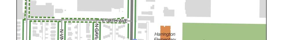
2 Introduction The Safe Routes to School programming grant 2013/04 was managed by Denver Health with funds from the Colorado Department of Transportation. Participating schools were selected based on an evaluation of Denver Public Schools elementary schools developed by Denver Health. The schools were categorized based on the following criteria: Enrollment and percent of student enrollment living within one mile Percent of students receiving free/reduced lunch Number of pedestrians involved in collisions and number of collisions during school hours (7:00AM 4:30PM) within one mile of the school The components of the grant included: Educational programming provided by Bicycle Colorado and Bike Denver Walk Audits provided by Walk Denver Community engagement provided by CREA Results Overview of the School and Neighborhood School Year Data Total Students Within 1 mile of school With free/reduced lunch Total traffic accidents While driving to school Wellness Team School hours % 97% 0 0 No 8 am 3 pm Harrington Elementary School is located in the Clayton Neighborhood of north central Denver. It is a one story brick building with distinctive red and beige banding. The school occupies about one half block at the west end of Schafer Park. The school is located on the north side of East 37 th Avenue opposite the termination of Josephine Street. The closest intersection is East 37 th and York Street. The playground is located on the east side of the school adjacent to the park, and the school parking lots are to the east and west of the school. The blocks to the south and east of the school and park are predominantly residential with a mix of single and multifamily housing. Across 37 th are two vacant properties. Buildings along the west side of York are a mix of residential and commercial/industrial. The former Air Force Accounting Center, now offices and community services, is immediately to the north along York. A substantial complex of industrial buildings occupy the land to the north of the school and park. The residential blocks to the east, south, and west are traditional with rectangular blocks and detached walks with tree lawns. 2 P age


 Area, which is planned for")

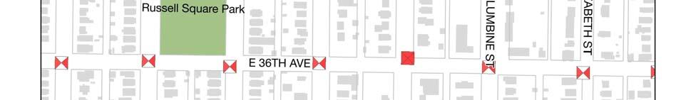
3 The school boundary is I 70/East 44 th on the north, Colorado Blvd on the east, East 37 th /Bruce Randolph, East 36 th on the south, and Gilpin/40 th /Blake/38 th streets on the west. The area north of East 40 th Avenue is predominantly industrial and is within the Elyria/Swansea Neighborhood. The large area at the northwest corner of East 38 th and York is a Union Pacific Railroad yard. Beyond the rail yard and tracks is the emerging RiNo (River North) Area, which is planned for mixed use in the future, but remains primarily industrial today. See school boundary map below. School Entrance Playground Two vacant lots with and without sidewalks across the street from the school The park to the east has a trail along the street rather than a sidewalk 3 P age
4 The Colorado Department of Transportation (CDOT) distributed a survey about walking and biking to 450 parents of children at Harrington; 74 (16%) responded. Forty three percent of the parents completed the survey in Spanish, and 57% in English. Their children represented all of the grades between pre kindergarten and fifth grade, with the majority (32%) in kindergarten. Twenty eight percent of respondents live less than ¼ mile from the school, and an additional 35% live within a mile. Twenty four percent of respondents reported that their child walks to school, 58% reported that they drive their child to school, and 8% use the school bus. Although 78% of respondents believe that walking or biking to school is very healthy or healthy for their child, 46% percent indicated they would not feel comfortable allowing their child walk or bike to school without an adult at any age. The survey asked parents about issues that affected their decision to allow, or not allow, their child to walk or bike to/from school. The chart below shows that the most commonly cited issues were distance (35%), safety of intersections and crossings (35%), and speed of traffic along the route (35%). Issues Affecting Decision to Allow (Or Not Allow) Child to Walk or Bike Safety of Intersections and Crossings Distance Speed of Traffic Along Route Violence or Crime Weather or climate Amount of Traffic Along Route Time Crossing Guards Sidewalks or Pathways Child's Participation in After School Adults to Bike/Walk With Convenience of Driving 7% 7% 20% 16% 14% 12% 35% 35% 35% 31% 28% 28% The survey also asked if parents would probably let their child walk or bike to/from school if the issues identified above were changed or improved. The chart below shows that respondents were mostly likely to allow their child to walk or bike if distance, weather/climate, or time were changed or improved, followed by safety of intersections and crossing, and speed of traffic along the route. 4 P age
5 Would you probably let your child walk or bike to/from school if this problem were changed or improved? Safety of Intersections and Crossings Distance Speed of Traffic Along Route Violence or Crime Weather or climate Amount of Traffic Along Route Time Crossing Guards Sidewalks or Pathways Child's Participation in After School Programs Adults to Bike/Walk With Yes No Not Sure Convenience of Driving 0% 5% 10% 15% 5 P age

6 WASHINGTON MARION LAFAYETTE LAFAYETTE HUMBOLDT FRANKLIN GILPIN GILPIN RACE JOSEPHINE COLUMBINE VINE RACE GAYLORD CLAUDE WILSON MADISON GARFIELD CLAUDE ELIZABETH COOK MONROE GARFIELD JACKSON JOSEPHINE COLUMBINE GARFIELD HIGH ELIZABETH GAYLORD CLAYTON FILLMORE ELIZABETH CLAYTON VINE HIGH MADISON MONROE HARRISON ALBION Harrington School Boundary 47TH I 70 NATIONAL WESTERN 46TH LAFAYETTE FRANKLIN BALDWIN 46TH I 70 EXIT 275B 46TH ALICE EXIT 275C 47TH STEAVENSON THOMPSON FILLMORE EXIT 276A MILWAUKEE 47TH VASQUEZ I 70 MONROE JACKSON 46TH EXIT 276B STAPLETON DELGANY 35TH 36TH WAZEE BLAKE 38TH 39TH 36TH ARKINS 40TH WALNUT BRIGHTON WYNKOOP BLAKE 40TH 38TH 44TH FRANKLIN WYNKOOP GILPIN 40TH 39TH 38TH HIGH HIGH RACE 44TH 38TH Harrington ELIZABETH 37TH THOMPSON CLAYTON 45TH 41ST FILLMORE FILLMORE MILWAUKEE 43RD MILWAUKEE SAINT PAUL SAINT PAUL STEELE ADAMS ADAMS COOK 42ND MADISON MADISON 39TH 45TH 44TH 42ND 38TH 41ST JACKSON HARRISON 37TH EXIT 276B 40TH COLORADO SMITH 31ST 32ND LAWRENCE ARAPAHOE 30TH 29TH CHAMPA WELTON 33RD CURTIS STOUT CALIFORNIA 28TH CLARKSON EMERSON 29TH LARIMER 31ST 34TH GLENARM TREMONT 25TH 35TH DOWNING 30TH TREMONT 33RD LAFAYETTE WALKWAY 28TH 27TH HUMBOLDT COLE MS WALK 30TH MANUAL HS 31ST BRUCE RANDOLPH GILPIN WILLIAMS 30TH MANUAL WALK MARTIN LUTHER KING WALKWAY RACE VINE GAYLORD YORK 30TH 33RD ELIZABETH ELIZABETH 35TH 36TH MARTIN LUTHER KING FILLMORE 28TH MILWAUKEE 29TH MILWAUKEE SAINT PAUL BRUCE RANDOLPH 27TH 30TH ADAMS ADAMS 36TH COOK COOK 31ST 33RD MADISON 30TH MONROE MONROE MONROE NEIL GARFIELD RICHARD ALLEN 26TH 36TH JACKSON HARRISON COLORADO HADDON ALBION ALBION ASH 30TH 28TH Denver Public Schools ASH 25TH BELLAIRE Department of Planning and Analysis Boundaries effective on July 1, 2001 Map last updated April 18, 2011 The Clayton Statistical Neighborhood is bounded by East 40 th Avenue on the north, Colorado Boulevard on the east, Martin Luther King Boulevard on the south and York Street on the west. The neighborhood takes its name from Clayton College located in the southeast corner of the neighborhood. The southern part of the neighborhood is predominantly residential, zoned Urban Neighborhood Context Single Unit (U SU) for the school and area to the west, south and east of the school and park. The area to the north is zoned industrial (I 1) and along York zoning is B 2 and U MX 3 consistent with the mix of industrial, commercial and residential uses. The population declined slightly between 2000 and 2010, in part due to smaller household size. Neighborhood Demographics Population 4,337 Average household size 3.0 Race/ethnicity African American 30.2% Latino 49.0% White 16.2% Owner occupancy 57.0% 6 P age
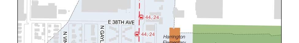
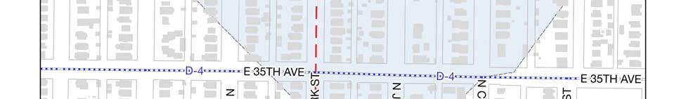
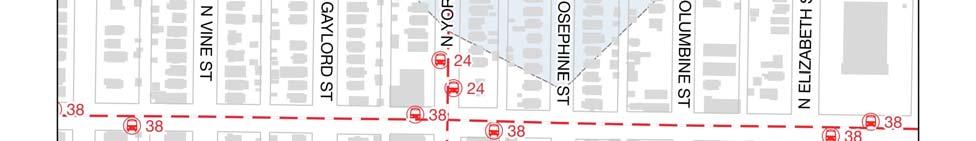
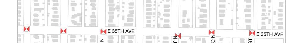
7 Parks Recreation Center Library Public Amenities Schafer Park adjacent to school; Russell Square to west St. Charles Recreation Center, 3777 Lafayette Street Ford Warren Branch Library, 2825 High Street Transportation Connections and Conditions (see maps below) Public transit (RTD) RTD Rte th Avenue RTD Rte 24 University/York&Josephine Bus stops at York and 38 th East Rail Line station at 38 th and Blake School buses (DPS) Shuttle service (Success Express) Major Streets East 37 th Avenue and York Street. 37 th Avenue is one way west bound for two blocks from Columbine to York. Traffic control Traffic signal at 37 th and York Bike routes Sidewalks Steele/St. Paul from 1 70 south to Highline Canal (D 13) East 35 th Avenue from Franklin to Stapleton Trail (D 4) The sidewalk infrastructure is incomplete or deteriorated in a number of locations near the school. 7 P age


8 8 P age


9 9 P age
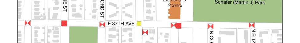
10 Walk Audit Results WalkDenver met with parents at on February 25, 2014 to introduce the Safe Routes to School program and interview the parents. James Schaffer and Ryan Sagar from WalkDenver made the presentation. About 18 parents/staff attended the meeting along with a Spanish interpreter. Those that do walk access the school on York, Josephine and East 37 th. On March 3 WalkDenver conducted an observation of the school drop off area during morning arrival. Key findings include the following: Sidewalk Conditions o Sidewalks are not always cleared during snowy months. o Sections of the sidewalk are missing on both the north and south sides of 37 th between Columbine and Josephine, and between York and Gaylord. Sidewalks on the south side of the street are very narrow. o Curb ramps are missing in several locations including 37 th and Clayton, and 37 th and Josephine. o Cars park across the sidewalk in several locations. Intersections o Crosswalks are missing along many intersections along 37th. o When kids exit the school, they take the most direct routes and do not use the crosswalks that are present. o 37 th and York has crosswalks and pedestrian signals, but is a high traffic intersection that parents still consider dangerous. o Parents noted the need for crossing guards. Traffic Safety and School Zone Signage o The change from two way to one way for a short distance on 37 th is confusing ad poorly marked. o Parents drive down the alleyway near the school and go the wrong way on 37 th to access the parking lot. Parents also turn left out of the parking lot ignoring the right turn only and one way signage. o Both pedestrians and cars use alleyways as shortcuts, which parents consider a hazard. o The school bus loading and passenger loading signs list inconsistent and inaccurate times. o No parking signs are parallel to the street, making them hard to see. o Parents noted that more signage, especially blinking school zone signs, are needed around the school. Drop off/pick up o Parents feel that drop off and pick up is very disorganized drivers want convenience and speed, and are poor role models for pedestrian safety. o Parents park on the south side of 37 th and let kids cross mid block to the school. 10 P age
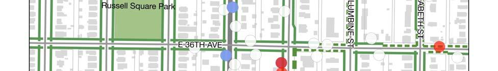
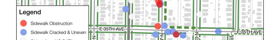
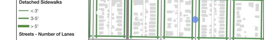
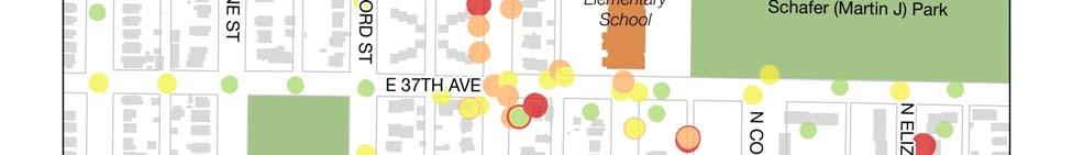
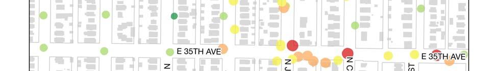
11 School Grounds o The turn around does not provide much space for parked and moving cars. o Better signage is needed for entry and exit of the parking lot current signs are too low and obscured by cars. o Recently rules for the adjacent park were changed to discourage loitering. Top Five Priorities: 1. Crossing guards 2. York and 37 th intersection 3. East parking lot 4. Parent behavior 5. Enforcement WalkDenver also conducted a technical audit of the pedestrian environment on April 12, 2014, when several volunteers used the WALKscope pedestrian data collection tool to record information about sidewalk and intersection quality throughout the Clayton neighborhood. All of the data collected, including images and commentary, can be viewed on the interactive map at The map below shows summary data on sidewalk conditions. Many of the sidewalks in the neighborhood are detached, meaning there is a buffer between the sidewalk and the street, and wider than three feet. In several cases, however, sidewalk conditions change mid block. Numerous obstructions and poor pavement conditions were noted on the sidewalks along York, Josephine, 37 th and 35 th. The second map below shows overall ratings of sidewalk and intersection quality on a scale from 1 (low) to 5 (high). This map illustrates the inconsistent quality of the pedestrian infrastructure, with low and high ratings mixed together throughout the neighborhood. The low ratings are most concentrated in the area bounded by York, Columbine, 38 th and 35th. To improve pedestrian conditions along these routes, WalkDenver recommends installing features aimed at slowing down traffic and shortening pedestrian crossings such as bulb outs, traffic circles, bike lanes etc. The first priority for these improvements is in the immediate vicinity of the schools. Low cost, interim design options can be incorporated using paint, flexible posts, epoxied gravel, interlocking pavers, etc. 11 P age


12 12 P age


13 13 P age
14 Recommendations Action Type Responsibility Timing 1. Encourage students and parents to walk to and from school Enroll Harrington in Fire Up Your Feet Behavior School administration Short term Encourage parents to participate in Behavior School administration Short term Way to Go School Pool Encourage DPS to adopt a district wide Behavior School administration/ Short term SRTS program DPS Improve sidewalk snow removal and Operational School administration Short term maintenance during the winter months. Conduct an audit of the current school zone signage, curb ramps and street lighting; request additional signage ramps and lighting where needed to meet standards Operational School administration/ DPS Medium term 2. Make needed pedestrian improvements Add or enhance crosswalks adjacent to school: Operational Denver Public Works Short term 37 th Avenue between Steele and York Provide crossing guards at 37th and Operational School administration/ Short term York DPS Add flashing school zone and Operational Denver Public Works Short term pedestrian crossing signs at 37 th and York Give signal priority to pedestrians Operational Denver Public Works Short term crossing York at 37 th during school hours Add or complete sidewalks adjacent to school: Public Improvement Denver Public Works Medium term 37 th Avenue between Steele and Gaylord Install curb ramps where missing along Public Denver Public Works Medium term East 37 th Avenue improvement Redesign pedestrian activation signals to be more visible Public improvement Denver Public Works Medium term 3. Improve the drop off and pick up experience Enforce speed and parking regulations Operational Denver Police Short term Establish, implement and enforce a school pick up and drop off policy Behavioral School administration/ DPS Short term Provide clear drop off/pick up protocol to parents Behavioral School administration/ DPS Short term 14 P age
15 Create a parent safety campaign to address speeding, double parking, and rolling stops. Develop a transportation management plan for pick up and drop off Behavioral Behavioral Clearly mark designated drop off and Operational pick up zones with signage and striping 4. Make needed street/public right of way improvements School administration/ DPS/Denver Police School administration/ DPS/Denver Public Works DPS/Denver Public Works Short term Medium term Medium term Post one way signs at intersections Operational Denver Pubic Works Short term with 37th Turn no parking sign faces Operational Denver Pubic Works Short term perpendicular to street Begin one way at Elizabeth rather than Operational Denver Pubic Works Medium term Columbine Convert alleys between 36 th and 37 th to one way northbound Operational Denver Pubic Works Medium term 5. Make safety improvements to school grounds Replace parking lot signs with standard Operational DPS Short term height signs Place no left turn signs/right turn only Operational DPS Short term signs at exits to parking lots Contact City of Denver Graffiti Hot Line to remove graffiti near school Operational School administration Short term 15 P age
16 Resources SRTS Community Connector: Fernando Pineda CREA Results Fire Up Your Feet The Fire Up Your Feet Program helps encourage families, students and schools to work together and create active lifestyles which inspire our children to be healthy and physically active. Everything is here to help you walk more, play more, and find the joy of being physically active as a family and in your school. WayToGo Schoolpool If you need help getting your kids to and from school, Way to Go can help you get started with Schoolpool for FREE. Our secure system will connect you with families in your neighborhood to share in the responsibilities of getting the kids to school and back via carpooling, walking, biking or riding RTD together. Thousands of other families are already connected what are you waiting for? Just try it! You ll gain support and a sense of community and get some much needed help in return. around/schoolpool Safe Routes to School District Policy Builder This tool walks the user through a series of policy options to help build a customized Safe Routes to School policy for school districts, which they can then download for the school board to adopt. Safe Routes to School (SRTS) is a movement that is changing communities and making children healthier by getting them to use their own power to get to and from school. Ensuring children are active on their way to and from school will improve health outcomes for them, as well. solutions safe routes school national partnership release schooldistrict policy Denver Public Schools Cross Guard program contact: Valerie Barrientos Manager of Campus Security Office # Cell # Fax # Dispatch # valerie_barrientos@dpsk12.org Traffic Safety Enforcement Daniel McNulty Daniel.McNulty@denvergov.org To report any issues related to signage, safety, sidewalk conditions or crime: P age
Doull Elementary School
 Doull Elementary School Safe Routes to School Walking Audit and Recommendations WalkDenver Fall 2013 Doull Elementary School (ECE grade 5) 2520 South Utica Street, Denver 80219 This project was supported
Johnson Elementary School
 Johnson Elementary School Safe Routes to School Walking Audit and Recommendations WalkDenver Fall 2013 Johnson Elementary School 1850 South Irving Street, Denver 80219 This project was supported by Safe
CITY OF OAK CREEK SAFE ROUTES TO SCHOOL ACTION PLAN. East Middle School
 CITY OF OAK CREEK SAFE ROUTES TO SCHOOL ACTION PLAN East Middle School CITY OF OAK CREEK SAFE ROUTES TO SCHOOL ACTION PLAN East Middle School Why Safe Routes to School? Safe Routes to School ( SRTS ) is
Safe Routes to School: Munroe Elementary Walk Audit Report. Image: Drexel, Barrell & Co.
 Safe Routes to School: Munroe Elementary Walk Audit Report Image: Drexel, Barrell & Co. April 12, 2016 OVERVIEW As part of the 2014/2015 Denver Safe Routes to School (SRTS) Program, WalkDenver coordinated
C/CAG. Sunnybrae Elementary School Walking and Bicycling Audit. San Mateo-Foster City School District JUNE 2013
 Sunnybrae Elementary School Walking and Bicycling Audit JUNE 2013 San Mateo-Foster City School District C/CAG City/County Association of Governments of San Mateo County SUNNYBRAE ELEMENTARY SCHOOL WALKING
SAFE ROUTES TO SCHOOL
 SAFE ROUTES TO SCHOOL Edgewood Elementary School Existing Conditions and ACTION PLAN > Oak Creek - Franklin Joint School District Table of Contents CONTEXT Enrollment Boundaries Enrollment
Parent Survey Report: One School in One Data Collection Period
 Parent Survey Report: One School in One Data Collection Period School Name: Bilquist Elementary School Set ID: 15803 School Group: Clackamas County Month and Year Collected: December 2016 School Enrollment:
Vallecito Elementary School. Travel Plan
 Vallecito Elementary School Travel Plan TABLE OF CONTENTS 1. PURPOSE... 1 1.1. SR2S PLANNING, IMPLEMENTATION AND MONITORING... 1 1.2. MARIN COUNTY MEASURE A... 1 2. VALLECITO ELEMENTARY SCHOOL PROFILE...
Safe Routes to School: Valverde Elementary Walk Audit Report. Image: CPLIVE, SkyscraperPage.com
 Safe Routes to School: Valverde Elementary Walk Audit Report Image: CPLIVE, SkyscraperPage.com April 28, 2016 1 OVERVIEW As part of the 2014/2015 Denver Safe Routes to School (SRTS) Program, WalkDenver
Hedgepeth Williams Middle School and Paul Robeson Elementary School Trenton, NJ. School Travel Plan
 Hedgepeth Williams Middle School and Paul Robeson Elementary School Trenton, NJ School Travel Plan Hedgepeth Williams Middle School Description: Hedgepeth-Williams Middle School is located at 301 Gladstone
TRAFFIC ACTION PLAN. North Central Neighborhood CITY OF SAN MATEO
 TRAFFIC ACTION PLAN North Central Neighborhood CITY OF SAN MATEO Draft February 2017 Table of Contents Introduction... 1 The Traffic Forum Process... 4 Neighborhood Traffic Issues... 6 Neighborhood Recommendations
SAFE ROUTES TO SCHOOL
 SAFE ROUTES TO SCHOOL Forest Ridge Elementary School Existing Conditions and ACTION PLAN > Oak Creek - Franklin Joint School District Table of Contents CONTEXT Enrollment Boundaries
Project Data Sheets. Friday, February 18, 2011
 Project Data Sheets Friday, February 18, 2011 KEY1 Relocate the proposed 38th Street pedestrian bridge over the railroad to 36th Street Eagle P3 Mid Term RTD/ The EIS proposed pedestrian bridge accommodates
Downtown Denver Summer 2011 Pedestrian Count Report. Funded by the Downtown Denver Business Improvement District
 Downtown Denver Summer 2011 Pedestrian Count Report Funded by the Downtown Denver Business Improvement District Overview The Downtown Denver Business Improvement District (BID) funds pedestrian counts
San Ramon Elementary School. Travel Plan
 San Ramon Elementary School Travel Plan TABLE OF CONTENTS 1. PURPOSE... 1 1.1. SR2S PLANNING, IMPLEMENTATION AND MONITORING... 1 1.2. MARIN COUNTY MEASURE A... 1 2. SAN RAMON ELEMENTARY SCHOOL PROFILE...
July 5, Arthur R. Ware, Jr. Elementary School 2017 Safe Routes to School Walkabout Report
 July 5, 2017 Arthur R. Ware, Jr. Elementary School 2017 Safe Routes to School Walkabout Report 1 Walkabout Report Introduction On April 28, 2017, City, School, and SAWMPO staff met to conduct a Safe Routes
Aitkin School Routing Plan July 2010
 Aitkin School Routing Plan July 2010 Prepared by: Arrowhead Regional Development Commission Regional Planning Division Aitkin School Routing Plan July 2010 Aitkin School Routing Plan July 2010 Prepared
Draft North Industrial Area-Wide Traffic Plan
 Summary of North Industrial and Hudson Bay Industrial Recommended Improvements Table 1. Summary of s Item Location 1 2 3 4 5 6 7 8 9 10 11 12 Millar Ave north of 51st St Super 8 Motel back lane 400 Block
CONNECTING PEOPLE TO PLACES
 CONNECTING PEOPLE TO PLACES 82 EAST BENCH MASTER PLAN 07 Introduction The East Bench transportation system is a collection of slow moving, treelined residential streets and major arteries that are the
Tonight is for you. Learn everything you can. Share all your ideas.
 Strathcona Neighbourhood Renewal Draft Concept Design Tonight is for you. Learn everything you can. Share all your ideas. What is Neighbourhood Renewal? Creating a design with you for your neighbourhood.
Drag and drop pic and stretch/crop to the limits of the blue rectangle (delete this text box) Maxey Elementary School
 Maxey Elementary School") Drag and drop pic and stretch/crop to the limits of the blue rectangle (delete this text box) Maxey Elementary School SCHOOL ROUTE PLAN For MAXEY ELEMENTARY SCHOOL LOCATION 33 ORANGE COUNTY Prepared for:
Drag and drop pic and stretch/crop to the limits of the blue rectangle (delete this text box) Maxey Elementary School SCHOOL ROUTE PLAN For MAXEY ELEMENTARY SCHOOL LOCATION 33 ORANGE COUNTY Prepared for:
Chicago Safe Routes to School Safe Routes to High School (SRTS/SRTHS)
") Chicago Safe Routes to School Safe Routes to High School (SRTS/SRTHS) Marshall Community High School and Faraday Elementary School Recommended Improvements Agenda Goals Related Programs Project Location/Area
Chicago Safe Routes to School Safe Routes to High School (SRTS/SRTHS) Marshall Community High School and Faraday Elementary School Recommended Improvements Agenda Goals Related Programs Project Location/Area
PRINCE GEORGE S PLAZA METRO AREA PEDESTRIAN PLAN
 PRINCE GEORGE S PLAZA METRO AREA PEDESTRIAN PLAN May 28, 2008 Agenda Welcome and introductions Project overview and issue identification Planning context and strengths Design challenges and initial recommendations
Venetia Valley Elementary School. Travel Plan
 Venetia Valley Elementary School Travel Plan TABLE OF CONTENTS 1. PURPOSE... 1 1.1. SR2S PLANNING, IMPLEMENTATION AND MONITORING... 1 1.2. MARIN COUNTY MEASURE A... 1 2. VENETIA VALLEY ELEMENTARY SCHOOL
Introduction Additional Safe Routes to School Resources Main Street Elementary School Survey Results Field Audit...
 Contents Introduction... 2 Additional Safe Routes to School Resources... 2... 3 Survey Results... 4 Field Audit... 6 Proposed Safe Routes to School Elements... 9 Typical Safe Routes to School Summary...
Bremen Elementary. SAFE ROUTES TO SCHOOL TRAVEL PLAN October 9, 2012
 Bremen Elementary SAFE ROUTES TO SCHOOL TRAVEL PLAN October 9, 2012 Introduction The purpose of the Bremen Elementary Safe Route to School (SRTS) Plan is to encourage school age children to travel to school
Duwamish Way-finding and CTR Report
 V. North Tukwila When the North Tukwila Manufacturing and Industrial Center was designated in 1992 as part of the region s land use and transportation plan, the plan called for the area to set a light-rail
Agenda. Overview PRINCE GEORGE S PLAZA METRO AREA PEDESTRIAN PLAN
 PRINCE GEORGE S PLAZA METRO AREA PEDESTRIAN PLAN May 28, 2008 Agenda Welcome and introductions Project overview and issue identification Planning context and strengths Design challenges and initial recommendations
WALKscope Data Challenge Tip Sheet
 WALKscope Data Challenge Tip Sheet Help us map where sidewalks end and win prizes for your neighborhood! WalkDenver & Denver Environmental Health (DEH) s Community Active Living Coalition (CALC) are proud
Lawrence Safe Routes to School. Community Meeting January 14, 2015
 Lawrence Safe Routes to School Community Meeting January 14, 2015 Safe Routes to School The 6 E s Education Encouragement Enforcement Engineering Evaluation Equity What are the elements of a SRTS plan?
2 Mark Twain Elementary School Report
 2 Mark Twain Elementary School Report Principal: Greg Kaatz Grades: K-2 Enrollment: 323 Address: 425 N. Church Street First bell: 8:10 a.m. Silverton, OR 97381 Last bell: 2:30 p.m. Free & Reduced Lunch:
Chapter 13 ORANGE COVE
 Chapter 13 ORANGE COVE This chapter describes the current status and future plans for biking and walking in the City of Orange Cove. RELATIONSHIP TO CITY PLANS AND POLICIES The Orange Cove General Plan
Sardis Elementary School Road Safety Plan. Produced by: Sardis Elementary School - Safer School Travel Team in cooperation with Safer City
 Sardis Elementary Road Safety Plan Produced by: Sardis Elementary - Safer Travel Team in cooperation with Safer City Plan completed in January 2016 1 Acknowledgements It takes commitment and community
Watertown Complete Streets Prioritization Plan. Public Meeting #1 December 14, 2017
 Watertown Complete Streets Prioritization Plan Public Meeting #1 December 14, 2017 Goals for Public Meeting Overview of MassDOT Complete Streets Funding Program Educate the community on Complete Streets
Denver Moves: Pedestrian and Trails Task Force Meeting 3 Notes November 16, :00 11:00 am
 Denver Moves: Pedestrian and Trails Task Force Meeting 3 Notes November 16, 2016 9:00 11:00 am Public Comment Meeting not on the Denveright calendar please add future Task Force meetings to calendar October
EXECUTIVE SUMMARY. Vision
 Vision Walking and bicycling in Salt Lake City will be safe, convenient, comfortable, and viable transportation options that connect people to places, foster recreational and economic development opportunities,
Wellington Exempted Village School District SAFE ROUTES TO SCHOOL TRAVEL PLAN January 2014
 Wellington Exempted Village School District SAFE ROUTES TO SCHOOL TRAVEL PLAN January 2014 OHIO SAFE ROUTES TO SCHOOL WELLINGTON EXEMPTED VILLAGE SCHOOL DISTRICT TRAVEL PLAN SECTION 1: WELLINGTON EXEMPTED
S A F E R O U T E S T O S C H O O L H E R M A N TOW N S C H O O L S A N D P R O C TO R S C H O O L S P L A N A P P R OVA L S
 S A F E R O U T E S T O S C H O O L H E R M A N TOW N S C H O O L S A N D P R O C TO R S C H O O L S P L A N A P P R OVA L S WHAT IS SAFE ROUTES TO SCHOOL? In 1969, nearly 50% of children walked or rode
PRESS RELEASE San Joaquin Council of Governments
 PRESS RELEASE San Joaquin Council of Governments For Immediate Release February 23, 2018 Contact: Nicole Gorham, 235-0582 gorham@sjcog.org SJCOG Board Awards $19.63 Million in Measure K Bicycle, Pedestrian,
7/23/2017 VIA . Michael Hanebutt City of Sacramento Community Development Department 300 Richards Boulevard, 3 rd Floor Sacramento, CA 95811
 7/23/2017 VIA EMAIL Michael Hanebutt City of Sacramento Community Development Department 300 Richards Boulevard, 3 rd Floor Sacramento, CA 95811 RE: 65 th Street Apartments (DR17-220) Dear Mr. Hanebutt:
Randolph-Hamline ( Ran-Ham ) Area Safe Routes to School Plan
 Area Safe Routes to School Plan") Randolph-Hamline ( Ran-Ham ) Area Safe Routes to School Plan Cretin Derham Hall Expo Elementary Holy Spirit Elementary Randolph Heights Elementary Saint Paul, Minnesota September 2016 Prepared By: Saint
Randolph-Hamline ( Ran-Ham ) Area Safe Routes to School Plan Cretin Derham Hall Expo Elementary Holy Spirit Elementary Randolph Heights Elementary Saint Paul, Minnesota September 2016 Prepared By: Saint
Merrick and Memorial Neighborhood Study 5/14/2014 Public Meeting
 Merrick and Memorial Neighborhood Study 5/14/2014 Public Meeting Study Area April 9 Public Meeting Comments Summary Pedestrian Safety - A Walking Neighborhood Pedestrian traffic is very difficult A need
West Capitol Avenue Road Rehabilitation and Safety Enhancement Project
 West Capitol Avenue Road Rehabilitation and Safety Enhancement Project Stakeholder Focus Group Meeting #2 Tuesday, August 28, 2018 7:00 8:00 a.m. West Sacramento City Hall 1110 West Capitol Avenue, West
The Leadville Bikeway Design Recommendations DRAFT January 2018
 The Leadville Bikeway Design Recommendations DRAFT January 2018 Overview The Leadville Bikeway project aims to create a bikeway that is compatible with and adds value to the neighborhood and surrounding
50 Avenue S.W. Corridor Study Glenmore Aquatic Centre Drop-In Event
 Project overview The City of Calgary is conducting a transportation corridor study of 5 Avenue S.W., between Crowchild Trail and 4A Street S.W. In 29, it was reclassified as a Parkway under the Calgary
TRAFFIC ACTION PLAN. Laurie Meadows Neighborhood CITY OF SAN MATEO
 TRAFFIC ACTION PLAN Laurie Meadows Neighborhood CITY OF SAN MATEO Draft January 2017 Table of Contents Introduction... 2 The Traffic Forum Process... 5 Neighborhood Traffic Issues... 7 Neighborhood Recommendations
Corporate. Report COUNCIL DATE: May 25, 1998 NO: R1500 REGULAR COUNCIL. TO: Mayor & Council DATE: April 27, 1998
 R1500 : Traffic Safety at 25 Avenue and 128 Street Intersection Corporate NO: R1500 Report COUNCIL DATE: May 25, 1998 REGULAR COUNCIL TO: Mayor & Council DATE: April 27, 1998 FROM: General Manager, Engineering
EXECUTIVE SUMMARY: TRANSIT-ORIENTED DEVELOPMENT IN SMITHS FALLS, ONTARIO; A COMPARISON BETWEEN TWO SITES
 EECUTIVE SUMMARY: TRANSIT-ORIENTED DEVELOPMENT IN SMITHS FALLS, ONTARIO; A COMPARISON BETWEEN TWO SITES Topic and Purpose In 2007, the Mayor of Ottawa s Task Force on Transportation suggested adding a
Parent Survey Report: One School in One Data Collection Period
 Parent Survey Report: One School in One Data Collection Period School Name: Pinckney Elementary School Set ID: 12170 School Group: Douglas County Month and Year Collected: October 2014 School Enrollment:
12/4/2016 VIA . RE: Grocery Outlet Del Paso (DR16-328)
") 12/4/2016 VIA EMAIL Ethan Meltzer, Assistant Planner City of Sacramento Community Development Department 300 Richards Blvd, 3 rd Floor Sacramento, CA 95811 RE: Grocery Outlet Del Paso (DR16-328) Dear Mr.
12/4/2016 VIA EMAIL Ethan Meltzer, Assistant Planner City of Sacramento Community Development Department 300 Richards Blvd, 3 rd Floor Sacramento, CA 95811 RE: Grocery Outlet Del Paso (DR16-328) Dear Mr.
2.0 Existing Conditions
 20 2.0 Existing Conditions 2.1 Land Use, Future Growth Patterns, Physical Barriers Geographic Overview Sutter County s land use pattern is characterized by extensive agricultural areas, significant natural
Arlington Public Schools Thomas Jefferson Site Evaluation Transportation Networks. Thomas Jefferson Working Group Meeting #6 November 10, 2014
 Arlington Public Schools Thomas Jefferson Site Evaluation Transportation Networks Thomas Jefferson Working Group Meeting #6 November 10, 2014 2 3 INTRODUCTION 4 Goal of our work: Identify and assess multi-modal
complete streets design and construction standards public primer City of Edmonton
 complete streets design and construction standards public primer City of Edmonton introduction Complete Streets are streets for everyone: people who walk, wheel, bike, take transit, or drive. They are
Improvements Infrastructure Gap Assessment and Improvements Street Striping
 Infrastructure Project Proposal The federal-aid Safe Routes to School program funds infrastructure/engineering projects that fall into two categories: Design (available only to School Development Authority
Orange Center Elementary School
 Drag and drop pic and stretch/crop to the limits of the blue rectangle (delete this text box) Orange Center Elementary School Drag and drop pic and stretch/crop to the limits of the blue rectangle (delete
RiNo Railroad Crossing Connectivity Analysis. Stakeholder Workshop June 29, 2017
 RiNo Railroad Crossing Connectivity Analysis Stakeholder Workshop June 29, 2017 Ideas and Considerations Presented at Stakeholder Workshop Primary Focus: 38 th Street (between Walnut & Wynkoop) 1 Basic
CURBSIDE ACTIVITY DESIGN
 5 CURBSIDE ACTIVITY DESIGN This chapter provides design guidance for separated bike lanes adjacent to curbside activities including parking, loading and bus stops. Typical configurations are presented
WELCOME Mission-Geneva Transportation Study
 WELCOME Mission-Geneva Transportation Study Study Process and Schedule 2005 2006 Oct Nov Dec Jan Feb Mar Apr May Jun Jul Aug Sept Oct Task 2 Develop Outreach Plan Task 3 Document Existing Conditions/ Prioritize
Figure 4-10: Pedestrian Improvements Types of Potential Station Area Improvements - Place-Making Improvements
 INCORPORATE FEATURE PAVIN IN CROSSWALK AND INTERSECTION FIELDS Identifies high-priority pedestrian areas and create a station identity through colorful and interesting patterns ADD CURB EXTENSIONS Extending
Hidden Oaks Elementary School
 Hidden Oaks Elementary School SCHOOL ROUTE PLAN For HIDDEN OAKS ELEMENTARY SCHOOL LOCATION 13 ORANGE COUNTY Prepared for: ORANGE COUNTY SCHOOL ASSESSMENT PROGRAM ORANGE COUNTY PUBLIC WORKS Traffic Engineering
CITY OF KASSON TRANSPORTATION ALTERNATIVES KASSON SAFE ROUTES TO SCHOOL
 ve ha 8t G B A Mantorville Ave N 240th Ave 16th St NE 11th Ave NE K-M HIGH SCHOOL SUNRISE TRAIL TO MANTORVILLE MNTH 57 SUNSET TRAIL TO MANTORVILLE NE PARK 16TH ST NE TRAIL K-M ELEMENTARY SCHOOL K-M MIDDLE
Implementing the Three Es of School Zone Traffic Calming
 Implementing the Three Es of School Zone Traffic Calming Use this evaluation tool as a guide to analyze the specific safety needs of your school. SCHOOL PROFILE School Name: School District: Address: Phone
3 Silverton High School Report
 3 Silverton High School Report Principal: Justin Lieuallen Grades: 9-12 Enrollment: 1,277 Address: 1456 Pine Street First bell: 7:55 a.m. Silverton, OR 97381 Last bell: 3:05 p.m. Free & Reduced Lunch:
KEARNY MESA COMMUNITY PLAN UPDATE
 KEARNY MESA COMMUNITY PLAN UPDATE January 18, 2018 SUBCOMMITTEE MEETING Mobility Concepts and Urban Design Presentation Outline Mobility Concepts: Multimodal Planning Toolbox Presentation and Activities
Transportation 2040 Update: Eudora Public Input As of June 1, 2017
 Transportation 2040 Update: Eudora Public Input As of June 1, 2017 Overview... 1 Survey Responses... 2 Overview The Lawrence Douglas County Metropolitan Planning Organization (MPO) is updating our long
Microscale Audit of Pedestrian Streetscapes (MAPS), Mini Version
, Mini Version") Microscale Audit of Pedestrian Streetscapes (MAPS), Mini Version Training Manual & Picture Guide Developed by: Carrie Geremia Kelli Cain Revised February 11, 2014 Tool and protocol developed by: James
Microscale Audit of Pedestrian Streetscapes (MAPS), Mini Version Training Manual & Picture Guide Developed by: Carrie Geremia Kelli Cain Revised February 11, 2014 Tool and protocol developed by: James
David Hung, Associate Planner City of Sacramento Community Development Department 300 Richards Boulevard, 3 rd Floor Sacramento, CA
 June 13, 2016 VIA EMAIL David Hung, Associate Planner City of Sacramento Community Development Department 300 Richards Boulevard, 3 rd Floor Sacramento, CA 959811 RE: Fire Station 14 (DR16-128) Dear Mr.
Windy Ridge Elementary School
 Windy Ridge Elementary School SCHOOL ROUTE PLAN For WINDY RIDGE ELEMENTARY SCHOOL LOCATION 54 ORANGE COUNTY Prepared for: ORANGE COUNTY SCHOOL ASSESSMENT PROGRAM ORANGE COUNTY PUBLIC WORKS Traffic Engineering
Table #6 VISION CHARACTERISTICS
 Table #6 VISION White Flint is a place to live, work, play, shop, and walk with sufficient density to encourage quality redevelopment. Vibrant streets and consistent streetscapes are important. CHARACTERISTICS
Pedestrian Survey Report
 Pedestrian Survey Report The City of Albany conducted a Pedestrian Survey in 2007 with the purpose of identifying resident s concerns about barriers to walking and accessibility in the City. The survey
Parent Survey Report: One School in One Data Collection Period
 Parent Survey Report: One School in One Data Collection Period School Name: Broken Arrow Elementary School Set ID: 12172 School Group: Douglas County Month and Year Collected: October 2014 School Enrollment:
4.0 TRANSPORTATION SYSTEMS
 Transportation Systems 4.0 TRANSPORTATION SYSTEMS This chapter examines the impacts of the Central Corridor Extension on existing roadways and traffic operations and discusses the transit service, operations,
CHILLICOTHE CITY SCHOOLS. SAFE ROUTES TO SCHOOL TRAVEL PLANS for Allen, Mt. Logan, Tiffin & Worthington Elementary Schools January 2013
 CHILLICOTHE CITY SCHOOLS SAFE ROUTES TO SCHOOL TRAVEL PLANS for Allen, Mt. Logan, Tiffin & Worthington Elementary Schools January 2013 i Ohio s Safe Routes to School Travel Plan Template www.dot.state.oh.us/saferoutes
Rebecca Johnson Elementary School Walk Audit Springfield, MA. March 4, making massachusetts more walkable
 Rebecca Johnson Elementary School Walk Audit Springfield, MA March 4, 2015 Centers for Disease Control and Prevention Division of Community Health/Community Transformation Grant Mass in Motion, an initiative
Summary Report School Walking & Bicycling Audits. Mesa County Regional Transportation Planning Office
 Summary Report School Walking & Bicycling Audits Mesa County Regional Transportation Planning Office This page left blank intentionally WALKING & BICYCLING AUDIT SUMMARY 2 Executive Summary Background:
Bicycle and Pedestrian Facilities Toolbox (Excerpt from Figure 3.1)
") Appendix B Neighborhood Connections Summaries This Appendix is a supplement to the information presented in Chapter 3 Connect People. The Appendix includes a summary or profile for each of the proposed
Appendix B Neighborhood Connections Summaries This Appendix is a supplement to the information presented in Chapter 3 Connect People. The Appendix includes a summary or profile for each of the proposed
Complete Streets. Complete Streets and other City Initiatives. City & County Initiatives. Honolulu Complete Streets Program
 City & County Initiatives Complete Streets and other City Initiatives Health and the Built Environment Hawaii Public Health Conference Mark Garrity Department of Transportation Services City & County of
Introduction.
 2307-1.0. Introduction. Delaware s Safe Routes to School (SRTS) Program was established September 10, 2002 when Governor Ruth Ann Minner signed Senate Bill 353 of the 141st General Assembly of Delaware
Downtown Denver Summer 2013 Pedestrian Count Report
 Downtown Denver Summer 2013 Pedestrian Report Funded by the Downtown Denver Business Improvement District Downtown Denver Partnership, Inc. Research Department Research Department 511 16 th Street, Suite
o n - m o t o r i z e d transportation is an overlooked element that can greatly enhance the overall quality of life for the community s residents.
 N o n - m o t o r i z e d transportation is an overlooked element that can greatly enhance the overall quality of life for the community s residents. 84 Transportation CHAPTER 11 INTRODUCTION Transportation
Chapter 14 PARLIER RELATIONSHIP TO CITY PLANS AND POLICIES. Recommendations to Improve Pedestrian Safety in the City of Parlier (2014)
") Chapter 14 PARLIER This chapter describes the current status and future plans for biking and walking in the City of Parlier. RELATIONSHIP TO CITY PLANS AND POLICIES The Parlier General Plan is the primary
Chapter 14 PARLIER This chapter describes the current status and future plans for biking and walking in the City of Parlier. RELATIONSHIP TO CITY PLANS AND POLICIES The Parlier General Plan is the primary
Appendix C. TRAFFIC CALMING PROGRAM TOOLBOX
 Appendix C. TRAFFIC CALMING PROGRAM TOOLBOX PHASE I...2 Do Not Enter Sign...3 One-Way Sign...4 Turn Prohibition...5 Pavement Markings...6 Speed Monitoring Trailer...7 Neighborhood Speed Watch...8 Police
About the Studio. Edward J. Bloustein School of Planning and Public Policy - Rutgers University
 About the Studio Edward J. Bloustein School of Planning and Public Policy - Rutgers University Purpose of studio: Help City of Bayonne apply for Safe Routes to School (SRTS) funding by producing a School
Doing it Right: Leveraging Data and Evaluation to Develop Pedestrian Safety Projects
 Doing it Right: Leveraging Data and Evaluation to Develop Pedestrian Safety Projects 1 Safe Kids Overview 2 Our Mission We work to keep all kids safe from preventable injuries 3 Why It Matters 4 Where
SECTION 1 - CONTACT INFORMATION
 SECTION 1 - CONTACT INFORMATION Please complete the information below. The person identified as the Project Contact Person will be the primary point of contact for Georgia DOT staff. Organization: (Please
TRAFFIC CALMING GUIDE FOR TORONTO CITY OF TORONTO TRANSPORTATION SERVICES DIVISION
 TRAFFIC CALMING GUIDE FOR TORONTO CITY OF TORONTO TRANSPORTATION SERVICES DIVISION CITY OF TORONTO TRANSPORTATION SERVICES DIVISION 2016 TRAFFIC CALMING GUIDE FOR TORONTO TABLE OF CONTENTS Introduction
Transportation Planning Division
 Transportation Planning Division Presentation Outline Study Tasks Recap of Previous Meetings Data Collected Focus Areas within Study Limits Design Principles Tool Box Recommended Concepts Schedule Moving
ACTIVE TRANSPORTATION
 ACTIVE TRANSPORTATION Mobility 2040 Supported Goals Improve the availability of transportation options for people and goods. Support travel efficiency measures and system enhancements targeted at congestion
MARTIN LUTHER KING JR. WAY
 OCTOBER 2011 40 Vision and Goals The Martin Luther King, Jr. Way Illustrative Master Plan that follows has been developed through a process of community involvement. It expresses a long term vision for
Meadow Woods Elementary School
 Drag and drop pic and stretch/crop to the limits of the blue rectangle (delete this text box) Meadow Woods Elementary School Drag and drop pic and stretch/crop to the limits of the blue rectangle (delete
Sebastopol Charter School Traffic Management Plan
 Sebastopol Charter School The serves as the working document in support of these essential goals: to ensure the safety and efficiency of student arrival to and departure from school to ensure the safety
CLOSED. The draft concept design has been broken down into 5 categories for the purpose of this survey:
 Old Strathcona s neighbourhood renewal process is now at the draft concept design phase. Over the last several months, the city has been gathering local knowledge and resident input that has been used
Healthy Corridor Audit Tool
 Healthy Corridor Audit Tool How to Use:»» Complete the first section for the entire study area. Many indicators can be collected from existing data; they do not have to be collected on site.»» To assess
STEERING COMMITTEE MEETING June 17, Streetscape Overview Burlington Comprehensive Master Plan
 STEERING COMMITTEE MEETING June 17, 2015 Streetscape Overview Burlington Comprehensive Master Plan 1 Introduction Slide This slide show was presented to the Burlington Steering Committee on June 17, 2015
Mayor s Bicycle Advisory Council. Wednesday, December 13 th, 2017
 Mayor s Bicycle Advisory Council Wednesday, December 13 th, 2017 Bicyclist Fatalities, Year to Date (January 1 November 30, 2017) - MBAC Briefing Bicyclist Fatality Statistics Year to date total, 2017
SAFE ROUTES TO SCHOOL (SR2S)
") SAFE ROUTES TO SCHOOL (SR2S) In partnership with Burbank Unified School District (BUSD) & City of Burbank George Washington Elementary School Thomas Jefferson Elementary School John Muir Middle School
SAFE ROUTES TO SCHOOL (SR2S) In partnership with Burbank Unified School District (BUSD) & City of Burbank George Washington Elementary School Thomas Jefferson Elementary School John Muir Middle School
Arapahoe Square Zoning + Design Standards & Guidelines Task Force Meeting 9 January 27, 2016
 Arapahoe Square Zoning + Design Standards & Guidelines Task Force Meeting 9 January 27, 2016 Agenda 3:00 Opening/Welcome 3:15 Touch Base on Schedule and Milestones Moving Forward 3:20 Review the Overall
COMMUNITY MEETING AGENDA
 COMMUNITY MEETING AGENDA Welcome and Introductions SAFE Presentation Project Presentation Priorities Feedback Next Steps Q&A Santa Cruz Avenue Corridor Study 1 Santa Cruz Avenue Corridor Study Community
PROSPECT ELEMENTARY GIRARD INTERMEDIATE GIRARD JUNIOR HIGH
 PROSPECT ELEMENTARY GIRARD INTERMEDIATE GIRARD JUNIOR HIGH SAFE ROUTES TO SCHOOL SCHOOL TRAVEL PLAN January 8, 2014 2 SECTION 1: OUR SCHOOLS School District School Name School Address Grades served Girard
6/14/2013 VIA . Evan Compton, Associate Planner Community Development Department City of Sacramento 300 Richards Blvd Sacramento, CA 95814
 6/14/2013 VIA EMAIL Evan Compton, Associate Planner Community Development Department City of Sacramento 300 Richards Blvd RE: Sacramento Natural Foods Co-Op (P13-025) Dear Mr. Compton: WALKSacramento appreciates