6TH AVE N/BENCH BLGS Phase II
|
|
|
- Anis Summers
- 5 years ago
- Views:
Transcription

1 6TH AVE N/BENCH BLGS Phase II
2 Study Objectives Evaluate existing and future traffic conditions on Main Street between Airport Road and 1 st Avenue Determine what, if any design improvements should be considered for intersection of Main Street with: Bench Blvd/6 th Avenue 1 st Ave/US 87 Determine what, if any MetraPark events should utilize a release plan

3 Study area intersections Airport Rd 6 th Ave/Bench Blvd 4 th Ave 1 st Ave/US 87
4 Study Baseline Assumptions 1. Billings Bypass will be operational by Inner Belt Loop operational before Use existing coordinated signal timing
5 Data Collection April 2012 and again in July Past traffic reports and documentation associated with the 6th Avenue North to Bench Boulevard project. Field reconnaissance and observation. Parking information for MetraPark.
6 Site Observations Un-serviced demand at intersections due to congestion Heavy truck convoys cause lane blockage and spillback Lane choices and weaving can be challenging 1st Ave/US 87 intersection back up Very few pedestrians, except during Metra events Metrapark underutilizes the Main Street Bench intersection
7 Traffic Projections Projected existing traffic for 2020 and 2033 with and without bypass in place
8 EXISTING (2012) TRAFFIC
9 2033 TRAFFIC W/ BYPASS 2033 TRAFFIC W/OUT BYPASS
10 Projections Summary In 20 years, Main Street 4th Ave to Airport Rd Increase approx % with bypass Increase approx % without bypass In 20 years, Main Street 1 st Ave to 4 th Ave ADT increase approx 4% (1,300 vpd) with the bypass increase approx 40% (13,500 vpd) without bypass In 20 years, Bench Blvd (along MetraPark) Increase approx. 40% with bypass Increase approx. 65% without bypass In 20 years, right turn PM peak hr volume from US87 onto Main Street decreases from 836 vph (existing) to 256 vph with the bypass increases from 836 vph to 1200 vph without bypass.
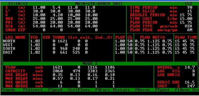
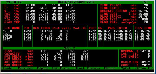
11 EXISTING LEVEL OF SERVICE (LOS) Intersection Avg Delay (s/veh) AM Peak LOS Existing (2012) Max Queue (veh) Avg Delay (s/veh) PM Peak LOS Max Queue (veh) Main St & Airport Rd 43.1 D D 30 Main St & Bench Blvd/6th Ave N 17.1 B A 42 Main St & 4th Ave N 11.1 B F 44 Main St & 1st Ave N/Hwy C C 25?
12 Intersection Approach 2033 LEVEL OF SERVICE Design Year (2033) without Bypass Avg Delay (s/veh) Design Year (2033) with Bypass AM Peak PM Peak AM Peak PM Peak LOS Max Queue (veh) Avg Delay (s/veh) LOS Max Queue (veh) Avg Delay (s/veh) LOS Max Queue (veh) Avg Delay (s/veh) Intersection Control Existing Traffic Signal Existing Traffic Signal Main Street & Airport Road Intersection F F F E 47 Intersection Control Existing Traffic Signal Existing Traffic Signal Main Street & Bench Blvd/ 6th Avenue N Intersection 75.1 E E C C 54 Intersection Control Existing Traffic Signal Existing Traffic Signal Main Street & 4th Avenue N Intersection 22.3 C F B F 74 Intersection Control Existing Traffic Signal Existing Traffic Signal Main Street & 1st Avenue N/Hwy 87 Intersection 34.2 C D 29? 32.8 C D 29? LOS Max Queue (veh)

13 6 th Avenue/Bench Blvd Main Intersection

14 ALTERNATIVES: 1. No-build this option would perpetuate existing conditions. 2. Roundabout construct a multilane roundabout 3. Combine 4 th Avenue and 6 th Avenue join 4 th Avenue to 6 th Avenue and Bench Blvd. 4. Signalized Intersection Improved construct improvements to the existing intersection 5. Overpass extend Bench Blvd over Main Street with or without ramps onto 6 th Ave and Main St 6. Underpass - underpass w/ 1-lane off-ramp to Main & 1-lane off-ramp to Bench 7. 4 th Avenue Flyover connect 4 th Avenue to Main Street via a flyover. and 4 th Ave to Bench Blvd via a one-lane structure

15 1. No Build

16 2. Roundabout

17 3. Combine 4 th and 6 th Avenue (at grade)
")
18 4th and 6th Avenue (at grade) snapshot

19 4. Signalized Intersection Improved
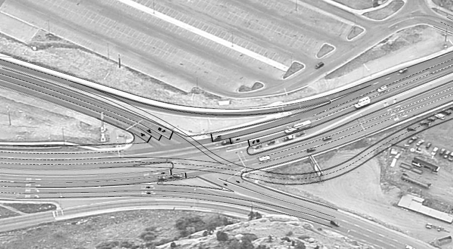
20 5. Overpass (by others)

21 6. Underpass (by others)

22 Overpass and Underpass
23 Concerns with Under/Overpass Weaving to make left turn at US87 Utilities underpass and oil line Costs structures are expensive Traffic Impacts during construction

24 Rendering of Bridge

25 7. 4 th Avenue Flyover
26
27 Decision Matrix 6 th Ave/Bench Blvd Main Street Criteria - Construction Impacts Do- Nothing Modify Existing Signal Roundabout Underpass Overpass 4 th Ave Flyover Combine 4 th and 6 th Mobility Utilities Right of Way Socio Economic Environmental Pedestrians MetraPark Transit Emergency Services
28 Decision Matrix 6 th Ave/Bench Blvd Main Street Criteria Environmental Do- Nothing Modify Existing Signal Rdbt Underpass Overpass 4 th Ave Flyover Combine 4 th and 6 th Viewshed Displacement of property Natural Resources Noise Business Primary Concern congestion congestion Land Req t Land Req t View View Land Req t
29 Criteria Transportation System Decision Matrix 6 th Ave/Bench Blvd Main Street Do Nothing Modify Existing Signal Rdbt Underpass Overpass 4 th Ave Flyover Combine 4 th & 6 th Level of Service C C F A* A* B F Motorist Delay Mobility Safety Traffic Patterns Future Capacity Emissions Pedestrians + + Local Planning MetraPark + + Primary Concern Capacity Cost vs Benefit Capacity Weaving on Main Weaving on Main Structure placement Capacity * don t forget about 4 th Ave; it will remain congested
30 Costs Criteria Costs Do Nothing Modify Existing Signal Rdbt Underpass Overpass 4 th Ave Flyover Combine 4 th and 6 th Construction CN +CE + + Utilities + + Right of Way + + ($15/ft) Traffic Control + + Fuel Consumption per year (no infl) Economic O & M

31 1 st Avenue/Main/US 87 Intersection

32 Right turn slip lane

33 Dual Right turn lane
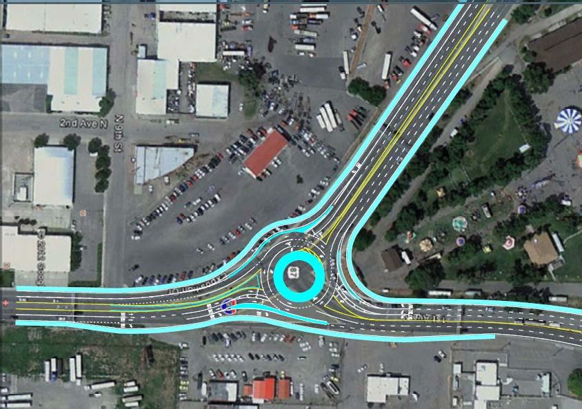
34 Roundabout
35 1 st Avenue/Main/US 87 Intersection LOS Results Intersection Avg Delay (s/veh) Existing (2012) Design Year (2033) with Bypass AM Peak PM Peak AM Peak PM Peak LOS Max Queue (veh) Avg Delay (s/veh) LOS Existing Traffic Signal Max Queue (veh) Avg Delay (s/veh) LOS Max Queue (veh) Avg Delay (s/veh) LOS Existing Traffic Signal Main Street & 1st Avenue N/Hwy C C C D 29 Max Queue (veh) Option 1: Elim outside NB Thru/Add WB free right 33.3 C E 52 Option 2: Add WB dual right 31.0 C E 29 Option 3: Roundabout 10.6 B C 6


36 MetraPark When is release plan needed?
37 MetraPark Release Plan Assumptions Event is coincident with average PM peak hour 2.5 occupants/vehicle Release occurs over a 1 hour period 50% of release traffic will enter through Bench/6 th Ave/Main intersection for SB travel on Main or WB travel on 6 th Ave Seating capacity of arena is 12,000 people, including 10,000 in regular seating and another 2,000 available floor seating
38 MetraPark Release Plan Results Release plan is required when an event yields 6000 (50% total capacity of arena) attendees and the event has a distinct end.
39 CONCLUSIONS 1. Main Street operates pretty well the majority of the time. 2. Traffic will increase slightly until 2020 (Billings Bypass is operational). 3. When bypass opens, traffic will drop very quickly on Main Street and US After initial drop, traffic will gradually increase so by 2033 they are nearly the same as 2020 levels before bypass opened. 5. Although 2033 conditions are likely to produce more delay and queue potential of vehicles, the intersections appear to operate within acceptable LOS. 6. The 6 th Ave/Bench and 1 st Ave/US 87 intersections will continue to operate well, with congestion similar to existing conditions through year The addition of another lane to Main Street demonstrates very little benefit. 8. The intersection of Airport Road and Main Street appears most likely to become saturated. 9. The Flyover concept at 6 th /Bench Main has a significant amount of merit for a future project, particularly from an emissions standpoint. 10. A noise analysis is likely justified with any major improvements. 11. Development per BIRD and EBURD could significantly change traffic conditions. Suggest reassessing after development plans are better known (2013)
40 Recommendation Main St/Bench Blvd Main St. intersection Option 1 DO NOTHING (reassess options after Bypass is open) Option 2 Flyover (long term bang for the buck) 1 st Ave/US 87 Main St intersection Option 1 DO NOTHING Option 2 Right turn slip lane (interim until 2020)
Casablanca Boulevard & GO Station Access
 Casablanca Boulevard & GO Station Access Class Environmental Assessment STAKEHOLDER WORKSHOP Thursday September 27th, 2018 5:30PM 8:00PM 1 WORKSHOP PURPOSE Provide an overview of the Design Alternatives
Colchester/Riverside/Barrett/ Mill Intersection Study. PAC Meeting #3 September 22, 2016
 Colchester/Riverside/Barrett/ Mill Intersection Study PAC Meeting #3 September 22, 2016 Tonight s Agenda Review Project Purpose and Need Describe short term and long improvements and changes since public
NO BUILD TRAFFIC OPERATIONS
 3. 23 NO BUILD TRAFFIC OPERATIONS This section addresses the operations of the transportation system and details how it would be expected to function under year 23 No Build conditions with the projected
Intersection of Massachusetts Avenue and Maple Street in Lexington Signalized Intersection and Roundabout Comparison
 Intersection of Massachusetts Avenue and Maple Street in Lexington Signalized Intersection and Roundabout Comparison Michael Wallwork, Roundabout Expert, Orange Park, Florida Tom Bertulis (MS, PE, PTOE),
City of CENTER. Welcome! from I-694 to TH 610. Public Open House
 Welcome! Public Open House Study Goals, & Objectives Goals: Establish the long-term vision for TH 252 Identify short-term improvements and strategies to address existing congestion, safety, and neighborhood
REDEVELOPMENT TRAFFIC IMPACT STUDY
 REDEVELOPMENT TRAFFIC IMPACT STUDY For Wendy s Parker, Colorado January 215 Prepared for: Sterling Design Associates, LLC 29 W. Littleton Boulevard #3 Littleton, Colorado 812 Prepared by: 1233 Airport
Intersection Improvement: Sturgeon Road, Silver Avenue and Murray Park Road Roundabout. Welcome. Public Information Session
 Intersection Improvement: 1 Welcome WHY IS AN INTERSECTION IMPROVEMENT NEEDED? 2 Traffic volumes for Sturgeon Road, Silver Avenue and Murray Park Road exceed the capacity of the existing 4-way stop controlled
Subject: Solberg Avenue / I-229 Grade Separation: Traffic Analysis
 MEMORANDUM Transportation Bill Troe, AICP Jason Carbee, AICP 12120 Shamrock Plaza Suite 300 Omaha, NE 68154 (402) 334-8181 (402) 334-1984 (Fax) To: Project File Date: Subject: Solberg Avenue / I-229 Grade
DOWNTOWN TUPELO MAIN STREET: ROAD DIET STUDY
 DOWNTOWN TUPELO MAIN STREET: ROAD DIET STUDY Since mid-2009, RPM Transportation Consultants (RPM) has worked with the Downtown Tupelo Main Street Association to evaluate traffic conditions and potential
Traffic Academy: IJS & IMS FAQ/RULES OF THUMB
 FAQ/RULES OF THUMB HCS intersection analysis criteria See LDM Figure 401-14aE Cycle lengths between 60 to 120 seconds No impractical phases, i.e., 1 second green time Yellow + All Red must be no less than
INNOVATIVE INTERSECTION DESIGN
 INNOVATIVE INTERSECTION DESIGN J. Eddie Valtier, P.E. ELP TP&D Director Introduction Why Do We Need To Start Looking For Innovative Intersection Designs? Congestion is worsening and traffic volumes and
Access Management Benefits & Techniques. Access Management Workshop June 2, 2006
 Access Management Benefits & Techniques Access Management Workshop June 2, 2006 1 Benefits of Access Management Safety As access density increases, crash rates increase Increasing the density of access
Offset Single Point Interchange I-25 at Rio Bravo Boulevard Albuquerque, New Mexico
 Offset Single Point Interchange I-25 at Rio Bravo Boulevard Albuquerque, New Mexico INSTITUTE OF TRANSPORTATION ENGINEERS 2016 WESTERN DISTRICT MEETING JULY 11, 2016 7/11/2016 1 Project Vicinity Map 7/11/2016
Pensacola Beach. BOARD OF COUNTY COMMISSIONERS Special Meeting
 Pensacola Beach Congestion Management Plan BOARD OF COUNTY COMMISSIONERS Special Meeting Board Chambers Suite 100 Ernie Lee Magaha Government Building - First Floor 221 Palafox Place http://www.myescambia.com/pensacola-beach/congestion-management-plan
Route 7 (East Market Street) Interchange at Battlefield Parkway Town of Leesburg Project No: UPC Presentation to Town Council
 Interchange at Battlefield Parkway Town of Leesburg Project No: UPC Presentation to Town Council") Route 7 (East Market Street) Interchange at Battlefield Parkway Town of Leesburg Project No: 0007-253-109 UPC 106573 Presentation to Town Council June 26, 2017 Council Decisions East Market Street / Battlefield
Route 7 (East Market Street) Interchange at Battlefield Parkway Town of Leesburg Project No: 0007-253-109 UPC 106573 Presentation to Town Council June 26, 2017 Council Decisions East Market Street / Battlefield
University Hill Transportation Study Technical Memorandum Alternatives Modeling and Analysis May 2007
 Technical Memorandum May 2007 Syracuse Metropolitan Transportation Council Edwards and Kelcey with Wallace Roberts and Todd Alta Planning and Design CONTENTS SECTION ONE- INTRODUCTION...1 SECTION TWO-
Freeway System Considerations
 Session 11 Jack Broz, PE, HR Green May 5-7, 2010 Freeway System Considerations Mainline Transit: Shoulder Operations, BRT, Stations HOV, HOT, UPA Interchanges Exit Ramps Entrance Ramps Bridges Local Crossings
HCM Sixth Edition. Plus More. Rahim (Ray) Benekohal University of Illinois at Urban Champaign,
 Benekohal University of Illinois at Urban Champaign,") HCM Sixth Edition What s New in the HCM Sixth Edition Plus More Rahim (Ray) Benekohal University of Illinois at Urban Champaign, 65 th Traffic Engineering and Safety Conference October 19 20, 2016 Institute
HCM Sixth Edition What s New in the HCM Sixth Edition Plus More Rahim (Ray) Benekohal University of Illinois at Urban Champaign, 65 th Traffic Engineering and Safety Conference October 19 20, 2016 Institute
EXECUTIVE SUMMARY. Page 1 of 6
 EXECUTIVE SUMMARY The purpose of this report is to identify conformance with the original traffic impact study for the proposed retail development on Lot 5 of Riverdale Retail Filing No. 1 located on the
Managed Lanes. Steve Schilke, P.E. Major Projects Unit Head District 1. Illinois Traffic Engineering and Safety Conference October 2016
 Managed Lanes Steve Schilke, P.E. Major Projects Unit Head District 1 Illinois Traffic Engineering and Safety Conference October 2016 Agenda Managed Lanes Projects I-55 (Stevenson Expressway) Express Toll
Access Routes from US 101 to the Richmond San Rafael Bridge
 Access Routes from US 101 to the Richmond San Rafael Bridge TAM Board Meeting January 28, 2016 RSRB Project Elements Eastbound Third Lane: Sir Francis Drake Blvd. to Marine Street 10 ft Barrier Separated
Evaluating Roundabout Capacity, Level of Service and Performance
 Roundabouts with Metering Signals ITE 2009 Annual Meeting, San Antonio, Texas, USA, August 9-12, 2009 Evaluating Roundabout Capacity, Level of Service and Performance Presenter: Rahmi Akçelik rahmi.akcelik@sidrasolutions.com
WELCOME. Stakeholder Involvement Group Meeting #2 Round Lake Public Works October 24, 2018
 WELCOME Stakeholder Involvement Group Meeting #2 Round Lake Public Works October 24, 2018 MEETING AGENDA 1. Welcome and Introductions 2. Study Progress Update 3. Problem Statement 4. Technical Analysis
Traffic Signal Design
 Traffic Signal Design Instructor: S. M. Mahdi Amiripour m.amiripour@gmail.com 2 Introduction Intersection is an area shared by two or more roads Designated for the vehicles to turn to different directions
Nixon, Green, and Dhu Varren Roads. Intersection Improvement Study
 Nixon, Green, and Dhu Varren Roads Intersection Improvement Study Background Public Discussion October 2013 Over 100 people participated Summary available at project website Intersection Study Started
Route 7/15 Norwalk. Route 7/15 Norwalk Project Project Advisory Committee Meeting #2. Tuesday, May 23 rd, Norwalk City Hall
 Project Project Advisory Committee Meeting #2 PAC Meeting #2 May 23, 2017 Tuesday, May 23 rd, Norwalk City Hall - AGENDA Introductions PAC Meeting #1 Summary Overview of Traffic Conditions Bicycle and
Highway 49, Highway 351 and Highway 91 Improvements Feasibility Study Craighead County
 Highway 49, Highway 351 and Highway 91 Improvements Feasibility Study Craighead County Executive Summary March 2015 Highway 49, Highway 351 and Highway 91 Improvements Feasibility Study Craighead County
4.12 TRANSPORTATION Executive Summary. Setting
 4.12 TRANSPORTATION 4.12.1 Executive Summary This section is based on the Multimodal Transportation Impact Study (TIS; 2016) prepared by Omni-Means, Ltd. to evaluate projected transportation impact conditions
Gap Acceptance Cycles for Modelling Roundabout Capacity and Performance
 15th Scientific and Technical Conference Transport Systems Theory and Practice Department of Transport Systems and Traffic Engineering, Faculty of Transport, Silesian University of Technology, Katowice,
Chapter 4 Traffic Analysis
 Chapter 4 Traffic Analysis PURPOSE The traffic analysis component of the K-68 Corridor Management Plan incorporates information on the existing transportation network, such as traffic volumes and intersection
Reference: Laguna Canyon Road Traffic Conditions Data Collection Summary
 Stantec Consulting Services Inc. 38 Technology Drive Suite 100, Irvine CA 92618-5312 September 8, 2017 File: 2073014320 Attention: Mark Trestik, Assistant City Engineer City of Beach Department of Public
FINAL DESIGN TRAFFIC TECHNICAL MEMORANDUM
 FINAL DESIGN TRAFFIC TECHNICAL MEMORANDUM July 2014 FINAL (SR 43) Project Development and Environment Study From State Road 60 (Adamo Drive) to I-4 (SR 400) Hillsborough County, Florida Work Program Item
Conversation of at Grade Signalized Intersection in to Grade Separated Intersection
 IJIRST International Journal for Innovative Research in Science & Technology Volume 2 Issue 05 October 2015 ISSN (online): 2349-6010 Conversation of at Grade Signalized Intersection in to Grade Separated
Roundabout Feasibility Memorandum
 Roundabout Feasibility Memorandum To From Gwen Pipkin Bill Howell Date June 18, 2013 Subject Roundabout Feasibility Study SR 29 PD&E Study From Oil Well Road to SR 82 Collier County, FL FPID 417540-1-22-01
DUNBOW ROAD FUNCTIONAL PLANNING
 DUNBOW ROAD FUNCTIONAL PLANNING Final Report August 3, 216 #31, 316 5th Avenue NE Calgary, AB T2A 6K4 Phone: 43.273.91 Fax: 43.273.344 wattconsultinggroup.com Dunbow Road Functional Planning Final Report
WISCONSIN AVENUE EXTENSION SECOND PUBLIC INFORMATION MEETING. March 28, 2017
 WISCONSIN AVENUE EXTENSION SECOND PUBLIC INFORMATION MEETING March 28, 2017 STUDY AREA N MEETING AGENDA Introductions Study Background Alternatives Studied Recommended Alternative Discussion STUDY BACKGROUND
Intersection Control Evaluation Report Project: Alternative: Location: Evaluator:
 Report Project: Alternative: Location: Evaluator: Franklin/Interstate-15 Interchange City of Lake Elsinore, 33 40'13.08"N 117 18'34.30"W Jeffrey Hsu 1 Introduction Policy Directive 13-02 calls for the
PRELIMINARY DRAFT WADDLE ROAD / I-99 INTERCHANGE PROJECT ALTERNATIVE ANALYSIS FINAL TRAFFIC SUMMARY REPORT
 PRELIMINARY DRAFT WADDLE ROAD / I-99 INTERCHANGE PROJECT ALTERNATIVE ANALYSIS FINAL TRAFFIC SUMMARY REPORT Prepared by: In Association with: November 2013 EXECUTIVE SUMMARY Patton Township, in partnership
Project Report. South Kirkwood Road Traffic Study. Meadows Place, TX October 9, 2015
 Meadows Place, TX October 9, 2015 Contents 1 Introduction... 1 2 Data Collection... 1 3 Existing Roadway Network... 2 4 Traffic Volume Development... 2 5 Warrant Analysis... 3 6 Traffic Control Alternative
MEETING FACILITY 2901 GIBFORD DRIVE CITY OF OTTAWA TRANSPORTATION BRIEF. Prepared for: Holiday Inn Express 2881 Gibford Drive Ottawa, ON K1V 2L9
 MEETING FACILITY 2901 GIBFORD DRIVE CITY OF OTTAWA TRANSPORTATION BRIEF Prepared for: Holiday Inn Express 2881 Gibford Drive Ottawa, ON K1V 2L9 December 18, 2012 112-566 Brief_1.doc D. J. Halpenny & Associates
Defining Purpose and Need
 Advanced Design Flexibility Pilot Workshop Session 4 Jack Broz, PE, HR Green May 5-6, 2010 Defining Purpose and Need In your agency s project development process, when do design engineers typically get
Route 7 Corridor Study
 Route 7 Corridor Study Executive Summary Study Area The following report analyzes a segment of the Virginia State Route 7 corridor. The corridor study area, spanning over 5 miles in length, is a multi
Lincoln Avenue Road Diet Trial
 Lincoln Avenue Road Diet Trial Data Collection Report June 1, 2015 Department of Transportation Table of Contents I. Introduction...... 3 II. Data Collection Methodology & Results...... 5 A. Traffic Volume
Average Delay/Vehicle (sec/veh) Signalized. Unsignalized Intersection
 Signalized. Unsignalized Intersection") Attachment: Traffic Analysis Results Traffic simulation modeling analysis was completed for Santa Cruz Ave from Alameda De Las Pulgas to Junipero Serra Blvd. Analysis was performed for existing conditions
Attachment: Traffic Analysis Results Traffic simulation modeling analysis was completed for Santa Cruz Ave from Alameda De Las Pulgas to Junipero Serra Blvd. Analysis was performed for existing conditions
February 8, Ms. Jamie Jun, Esq. Fromhold Jaffe & Adams 789 East Lancaster Avenue, Suite 220 Villanova, PA 19085
 WWW.TRAFFICPD.COM February 8, 2016 Ms. Jamie Jun, Esq. Fromhold Jaffe & Adams 789 East Lancaster Avenue, Suite 220 Villanova, PA 19085 Re: Kohelet Yeshiva School Lower Merion Township, Montgomery County,
EXISTING (2006) CONDITIONS
 CONDITIONS") Section 2 EXISTING (2006) CONDITIONS This section provides a description of the existing transportation system in the study area and a comprehensive analysis of existing traffic operations and crash history.
Section 2 EXISTING (2006) CONDITIONS This section provides a description of the existing transportation system in the study area and a comprehensive analysis of existing traffic operations and crash history.
9 Leeming Drive Redevelopment Ottawa, ON Transportation Brief. Prepared By: Stantec Consulting Ltd.
 9 Leeming Drive Redevelopment Ottawa, ON Transportation Brief Prepared By: Stantec Consulting Ltd. TIA GUIDELINES CHECKLIST Report Context Municipal Address Comment: Section 1.1 Location relative to major
Highway 217 Corridor Study. Phase I Overview Report
 Highway 217 Corridor Study Phase I Overview Report November 3, 24 BACKGROUND AND OVERVIEW Study purpose The Highway 217 Corridor Study is developing multi-modal transportation solutions for traffic problems
Reference number /VP. Lafayette Downtown Congestion Study - Additional Traffic Analysis
 To James Hinkamp and Tony Coe, City of Lafayette Date January 19, 2017 Copies Reference number 243381/VP From Michael Iswalt and Vanessa Peers File reference 4-05 Subject Lafayette Downtown Congestion
5858 N COLLEGE, LLC N College Avenue Traffic Impact Study
 5858 N COLLEGE, LLC nue Traffic Impact Study August 22, 2016 Contents Traffic Impact Study Page Preparer Qualifications... 1 Introduction... 2 Existing Roadway Conditions... 5 Existing Traffic Conditions...
Arterial Traffic Analysis Some critical concepts. Prepared by Philip J. Tarnoff
 Arterial Traffic Analysis Some critical concepts Prepared by Philip J. Tarnoff Agenda Fundamentals Signal timing concepts Actuated signal controllers Developing timing plans Types of signal control First
Northbound San Jose Avenue & I-280 Off-Ramp Road Diet Pilot Project
 Project Overview Fed by a two-lane Interstate-280 (I-280) off-ramp, high vehicular volumes and speeds are longstanding issues along San Jose Avenue. Residents in the surrounding neighborhoods have expressed
THE NACTO MANUALS AND DESIGNING FOR VISION ZERO ZAKI MUSTAFA SHIRLEY ZAMORA
 THE NACTO MANUALS AND DESIGNING FOR VISION ZERO ZAKI MUSTAFA SHIRLEY ZAMORA NACTO Design Guides 2 City of Los Angeles Vision Zero 3 Vision Zero Roscoe Boulevard Corridor SHIRLEY ZAMORA TRANSPORTATION ENGINEERING
Minutemen Causeway Pedestrian Safety Study City of Cocoa Beach
 Minutemen Causeway Pedestrian Safety Study City of Cocoa Beach March 15, 2012 Traffic Planning and Design, Inc. 535 Versailles Drive Maitland, Florida 32751 www.tpdtraffic.com Traffic Planning and Design,
Gene Dillon Elementary School Traffic Study Division Street Site
 To: From: Dr. James Hess, Superintendent Jordan Schwarze, PE, Senior Engineer Matt Pacyna, PE, Senior Associate Date: March 30, 2016 Subject: Gene Dillon Elementary School Traffic Study reet Site Memorandum
Task Force Meeting #5, August 3, Prepared by DKS Associates
 Task Force Meeting #5, August 3, 2018 Prepared by DKS Associates Agenda 1. Agenda Review and Meeting #4 Recap 2. Review Project Goal, Data, and Project Ideas 3. Recommendations and Reporting a) Recommended
THE FUTURE OF THE TxDOT ROADWAY DESIGN MANUAL
 THE FUTURE OF THE TXDOT ROADWAY DESIGN MANUAL Kenneth Mora, P.E. (Design Division) 10/10/2017 Table of contents 1 2 Reduction in FHWA design controlling criteria Innovative Intersection Guidance 3-7 8-42
Harrah s Station Square Casino
 Transportation Analysis Harrah s Station Square Casino Pittsburgh, Pennsylvania Submitted To: City of Pittsburgh and Pennsylvania Gaming Control Board Prepared By: DKS Associates GAI Consultants December
Route 79/Davol Street Corridor Study
 Route 79/Davol Street Corridor Study Fall River, MA Public Information Meeting #2 November 21, 2013 Fall River Heritage State Park Fall River, MA Agenda Welcome and Introductions Overview of Study Process
MoPac South: Impact on Cesar Chavez Street and the Downtown Network
 MoPac South: Impact on Cesar Chavez Street and the Downtown Network Prepared by: The University of Texas at Austin Center for Transportation Research Prepared for: Central Texas Regional Mobility Authority
SH-6 Corridor Improvement Study Policy Committee Progress Report M O N D AY, J U N E 1 0, B R A Z O S C E N T E R
 SH-6 Corridor Improvement Study Policy Committee Progress Report M O N D AY, J U N E 1 0, 2 0 1 3 B R A Z O S C E N T E R Project Overview Study Goals and Objectives» Improve traffic flow» Reduce delay»
MnPASS System Today and the Future
 MnPASS System Today and the Future April 2010 By Nick Thompson Minnesota Department of Transportation Topics Minnesota s Current and Future MnPASS High Occupancy Toll Systems Overview of the MnPASS System
James M. Moore, Director of Planning & Building Services, Town of Fairfax. Victory Village Senior Housing Development Traffic Study
 Traffic Study To: From: James M. Moore, Director of Planning & Building Services, Town of Fairfax David Parisi, PE, TE, Parisi Transportation Consulting Date: October 14, 216 Subject: Victory Village Senior
I-264 CORRIDOR EVALUATION STUDY. September 7, 2016 Eric Stringfield VDOT Planning Director Chris Lawrence AECOM Senior Transportation Engineer
 I-264 CORRIDOR EVALUATION STUDY September 7, 2016 Eric Stringfield VDOT Planning Director Chris Lawrence AECOM Senior Transportation Engineer Study Overview Interchange Locations Study Context Follow-up
List of Display Boards
 List of Display Boards Welcome Introduction Municipal Class Environmental Assessment (EA) Process Need and Justification for an Interchange Alternatives for Evaluation Vertical and Horizontal Alignments
INNOVATIVE INTERSECTION SOLUTIONS. Jay Bockisch, PE, PTOE Senior Associate
 INNOVATIVE INTERSECTION SOLUTIONS Jay Bockisch, PE, PTOE Senior Associate INNOVATIVE INTERSECTION SOLUTIONS Innovative intersection overview Case studies Continuous flow intersection Modern roundabouts
ORANGE COUNTY PUBLIC WORKS TRAFFIC INVESTIGATIONS
 ORANGE COUNTY PUBLIC WORKS TRAFFIC INVESTIGATIONS STAFF REPORT OF: January 6, 2019 SUPERVISORIAL DISTRICT: 5 SUBJECT: LOCATION: INVESTIGATOR: O Neill Drive at Roanoke Drive; Ladera Ranch; TB 922-E6 Clever
Holland Tunnel Exit in NJ
 Holland Tunnel Exit in NJ Using Operational Changes to Enhance Tunnel Throughput IBTTA Maintenance & Operations Workshop Daniel Jacobs, General Manager Trans. & Revenue May 17, 2016 Holland Tunnel Opened
IMPACTS OF TRAFFIC RESTRICTIONS AND INFRASTRUCTURE IMPROVEMENTS ON DOWNTOWN PEAK HOUR CONGESTION: A SYNCHRO ANALYSIS FOR BELLEVUE, WASHINGTON
 Final Technical Report TNW2009-06 IMPACTS OF TRAFFIC RESTRICTIONS AND INFRASTRUCTURE IMPROVEMENTS ON DOWNTOWN PEAK HOUR CONGESTION: A SYNCHRO ANALYSIS FOR BELLEVUE, WASHINGTON Chris Masek, P.E. Nancy Nihan,
Signalized Intersections
 Signalized Intersections Kelly Pitera October 21, 2009 Topics to be Covered Introduction/Definitions D/D/1 Queuing Phasing and Timing Plan Level of Service (LOS) Signalized Intersections The good Reduce
Southwest Bus Rapid Transit (SW BRT) Functional Planning Study - Executive Summary January 19 LPT ATTACHMENT 2.
 Functional Planning Study - Executive Summary January 19 LPT ATTACHMENT 2.") Southwest Bus Rapid Transit (SW BRT) Functional Planning Study - Executive Summary 2011 January 19 1 of 19 Introduction This executive summary presents the results of the Southwest Bus Rapid Transit (SW
Southwest Bus Rapid Transit (SW BRT) Functional Planning Study - Executive Summary 2011 January 19 1 of 19 Introduction This executive summary presents the results of the Southwest Bus Rapid Transit (SW
Roundabouts and Bikes: Like Oil and Water or Peanut Butter and Bananas?
 Roundabouts and Bikes: Like Oil and Water or Peanut Butter and Bananas? 2017 APBP PDS Conference Memphis, Tennessee Alek Pochowski, AICP, PE Darren Buck June 27, 2017 Columbus Circle, New York City In
HCM 2010: ROUNDABOUTS. PRAVEEN EDARA, PH.D., P.E., PTOE UNIVERSITY OF MISSOURI - COLUMBIA
 HCM 2010: ROUNDABOUTS PRAVEEN EDARA, PH.D., P.E., PTOE UNIVERSITY OF MISSOURI - COLUMBIA EMAIL: edarap@missouri.edu OUTLINE Terminology used Input data needs Capacity of single and multilane roundabouts
Chapter 4 TOOLBOX AND SAMPLE BIKE BOULEVARD LAYOUT
 Chapter 4 TOOLBOX AND SAMPLE BIKE BOULEVARD LAYOUT OVERVIEW This chapter describes a cohesive set of strategies to create a bicycle boulevard, namely to make streets safer and more efficient for bicycle
GEARY BRT SIMULATION VISSIM Calibration and Existing Conditions Results
 GEARY BRT SIMULATION VISSIM Calibration and Existing Conditions Results Geary BRT Citizens Advisory Committee February 17, 2011 www.gearybrt.org Presentation Objectives 1. Overview of modeling process
HILTON GARDEN INN HOTEL HOTEL EXPANSION 2400 ALERT ROAD, OTTAWA TRANSPORTATION BRIEF. Prepared for:
 HILTON GARDEN INN HOTEL HOTEL EXPANSION 2400 ALERT ROAD, OTTAWA TRANSPORTATION BRIEF Prepared for: Bona Building & Management Co. Ltd. Place Vanier, 333 North River Road Vanier, Ontario K1L 8B9 October
THE LANDMARK AT TALBOT PARK
 TRAFFIC IMPACT STUDY FOR THE LANDMARK AT TALBOT PARK IN NORFOLK, VA INTERMODAL ENGINEERING, P.C. OCTOBER, 200 The Landmark at Talbot Park is a proposed redevelopment of the existing apartments along the
Intersection LOS Intersection level of service (LOS) is defined by the Highway Capacity Manual (HCM) by the following criteria:
 is defined by the Highway Capacity Manual (HCM) by the following criteria:") Page 2 of 9 Intersection LOS Intersection level of service (LOS) is defined by the Highway Capacity Manual (HCM) by the following criteria: Table 1 LOS Definitions Level of Signalized Un-Signalized Definition
Page 2 of 9 Intersection LOS Intersection level of service (LOS) is defined by the Highway Capacity Manual (HCM) by the following criteria: Table 1 LOS Definitions Level of Signalized Un-Signalized Definition
INDUSTRIAL BUILDING 3009 HAWTHORNE ROAD CITY OF OTTAWA TRANSPORTATION OVERVIEW REVISED. Prepared for: Canada Inc.
 INDUSTRIAL BUILDING 3009 HAWTHORNE ROAD CITY OF OTTAWA TRANSPORTATION OVERVIEW REVISED Prepared for: 7849648 Canada Inc. Octiober 1, 2015 114-598 Overview_2.doc D. J. Halpenny & Associates Ltd. Consulting
Traffic Impact Study. Crestline Piggly Wiggly Mountain Brook, Alabama. Goodwyn, Mills and Cawood, Inc. Birmingham, Alabama.
 Traffic Impact Study Crestline Piggly Wiggly Mountain Brook, Alabama Prepared for: Goodwyn, Mills and Cawood, Inc. Birmingham, Alabama September 214 Revision 1 October 214 Crestline Piggly Wiggly Mountain
US-6 Spanish Fork Fact Finding Study. December 2017
 US-6 Spanish Fork Fact Finding Study December 2017 US-6 Spanish Fork Fact Finding Study Avenue Consultants December 2017 US-6 Spanish Fork Fact Finding Study December 2017 Table of Contents 1 Introduction...
Northwest Corridor Project Interchange Modification, Interchange Justification and System Analysis Report Reassessment (Phase I)
") Northwest Corridor Project Interchange Modification, Interchange Justification and System Analysis Report Reassessment (Phase I) Introduction The Georgia Department of Transportation (GDOT) prepared a
Northwest Corridor Project Interchange Modification, Interchange Justification and System Analysis Report Reassessment (Phase I) Introduction The Georgia Department of Transportation (GDOT) prepared a
Traffic Circulation Study for Neighborhood Southwest of Mockingbird Lane and Airline Road, Highland Park, Texas
 ARIZONA TEXAS NEW MEXICO OKLAHOMA February 13, 2015 Mr. Meran Dadgostar P.E., R.S. Town of Highland Park 4700 Drexel Dr. Highland Park, Texas 75205 Re: Traffic Circulation Study for Neighborhood Southwest
Scottsdale Road/Rural Road Alternatives Analysis (AA) Study. Arizona ITE/IMSA Spring Conference March 7, 2012
 Study. Arizona ITE/IMSA Spring Conference March 7, 2012") Scottsdale Road/Rural Road Alternatives Analysis (AA) Study Arizona ITE/IMSA Spring Conference March 7, 2012 Study Location and Duration Primary Study Corridor (major focus of effort) Rural Road and Scottsdale
Scottsdale Road/Rural Road Alternatives Analysis (AA) Study Arizona ITE/IMSA Spring Conference March 7, 2012 Study Location and Duration Primary Study Corridor (major focus of effort) Rural Road and Scottsdale
Access Management Regulations and Standards
 Access Management Regulations and Standards Efficient highway operation Reasonable property access Concept of Access Management The way to manage access to land development while simultaneously preserving
INDUSTRIAL BUILDING 1660 COMSTOCK ROAD CITY OF OTTAWA TRANSPORTATION OVERVIEW. Prepared for:
 INDUSTRIAL BUILDING 1660 COMSTOCK ROAD CITY OF OTTAWA TRANSPORTATION OVERVIEW Prepared for: Simluc Contractors Limited 2550 Blackwell Street, Ottawa K1B 5R1 October 18, 2013 113-584 Overview_1.doc D. J.
I-35 COMAL COUNTY OPERATIONAL IMPROVEMENTS
 I- COMAL COUNTY OPERATIONAL IMPROVEMENTS OPEN HOUSE The environmental review, consultation, and other actions required by applicable Federal environmental laws for this project are being, or have been,
Traffic Impact Analysis Walton Acres at Riverwood Athletic Club Clayton, NC
 Traffic Impact Analysis Walton Acres at Riverwood Athletic Club Clayton, NC 1. TABLE OF CONTENTS INTRODUCTION...1 1.1. Site Location and Study Area...1 1.2. Proposed Land Use and Site Access...2 1.3.
City of Wausau Wausau Center Urban Design and Transportation Master Plan. Design Workshop // October 18, 2018
 City of Wausau Wausau Center Urban Design and Transportation Master Plan Design Workshop // October 18, 2018 Design Workshops // October 15-18 Workshop Study Evaluate circulation and parking patterns around
SR 9/I-95 Interchange at 45 th Street PD&E Study Palm Beach County, Florida FPID No.: FAP No.: ETDM No.
 SR 9/I-95 Interchange at PD&E Study Palm Beach County, Florida FPID No.: 436519-1-22-01 FAP No.: 0951-682-1 ETDM No.: 14225 Palm Beach County MPO October 19, 2017 SR 9/I-95 Interchange at PD&E Study Presentation
Chapter 5 5. INTERSECTIONS 5.1. INTRODUCTION
 Chapter 5 5. INTERSECTIONS 5.1. INTRODUCTION Intersections are the physical component of the roadways where two highways intersect. They are the most complex element of roadways, since it requires more
Basic Freeways and Multilane Highways (LOS) CIVL 4162/6162
 CIVL 4162/6162") Basic Freeways and Multilane Highways (LOS) CIVL 4162/6162 Learning Objectives Define uninterrupted facilities Determine LOS of Basic freeway segments Multilane highways Uninterrupted Flow Facilities Pure
Basic Freeways and Multilane Highways (LOS) CIVL 4162/6162 Learning Objectives Define uninterrupted facilities Determine LOS of Basic freeway segments Multilane highways Uninterrupted Flow Facilities Pure
Welcome. 53 Avenue Overpass over Whitemud Drive Rehabilitation. Public Information Session. Wednesday, March 9, :30-8:00 p.m.
 BRIDGE REHABILITATION Welcome 53 Avenue Overpass over Whitemud Drive Rehabilitation Public Information Session Wednesday, March 9, 2016 4:30-8:00 p.m. Tonight you can: Learn about the 53 Avenue Overpass
Chapter Capacity and LOS Analysis of a Signalized I/S Overview Methodology Scope Limitation
 Chapter 37 Capacity and LOS Analysis of a Signalized I/S 37.1 Overview The Highway Capacity Manual defines the capacity as the maximum howdy rate at which persons or vehicle can be reasonably expected
Final Project Prioritization Plan
 Final Project Prioritization Plan For the NM 599 Corridor Executive Summary I. EXECUTIVE SUMMARY NM 599 serves as a North/South by-pass for vehicles traveling through Santa Fe and a WIPP route for low
I 10 Phoenix to California Border Multimodal Corridor Profile Study
 I 10 Phoenix to California Border Multimodal Corridor Profile Study December 2012 Prepared by Arizona Department of Transportation 206 S. 17th Ave. Phoenix, AZ 85007 In cooperation with U.S. Department
Blair/Williamson Intersection Expressed Needs
 Blair/Williamson Intersection Expressed Needs NORTH Blair Street is a barrier for pedestrians and bicycles Relocate Capitol City Trail crossing from Blair Street and John Nolen Drive intersection to Williamson
YELLOWHEAD TRAIL / 149 STREET INTERCHANGE
 YELLOWHEAD TRAIL / 149 STREET INTERCHANGE WELCOME Today we are introducing the concept planning project for a new gradeseparated interchange at Yellowhead Trail and 149 Street PURPOSE Provide information
Appendix G: Future Conditions Traffic Analysis Memorandum
 ppendix G: Future Conditions Traffic nalysis Memorandum Prepared by: Bolton & Menk, Inc. Riverfront Drive Corridor Study ǀ T42.867 ppendix MEMORNDUM Date: pril, 27 To: Paul Vogel From: Ross B. Tillman,
The proposed development is located within 800m of an existing Transit Station where infill developments and intensification are encouraged.
 Stantec Consulting Ltd. 1331 Clyde Avenue, Suite 4 Ottawa ON K2C 3G4 Tel: (613) 722-442 Fax: (613) 722-2799 May 14, 213 File: 1638823 Robinson Park Development Corp. 5699 Power Road Ottawa, ON, K1G 3N4