Pensacola Beach. BOARD OF COUNTY COMMISSIONERS Special Meeting
|
|
|
- Scot Ross
- 5 years ago
- Views:
Transcription

1 Pensacola Beach Congestion Management Plan BOARD OF COUNTY COMMISSIONERS Special Meeting Board Chambers Suite 100 Ernie Lee Magaha Government Building - First Floor 221 Palafox Place May May 30, :30 p.m.


2 Public Involvement Meeting #1 Public Kick-off Pensacola Beach Community April 28, 2016 Attendees: 94 signed-in Witt Written Comments Received: 77 One on One Stakeholder Meetings: 18
3 Public Involvement Meeting #2 Public Input Pensacola Beach Community October 25, 2016 Attendees: 97 signed-in Written Comments: 40 One on One Stakeholder Meetings: 9
4 Public Involvement Meeting #3 Public Town Hall Downtown Board Chambers February 23, 2017 Attendees: 49 signed-in Written Comments: 11
5 Short Term Improvement Projects Aerial View

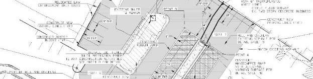
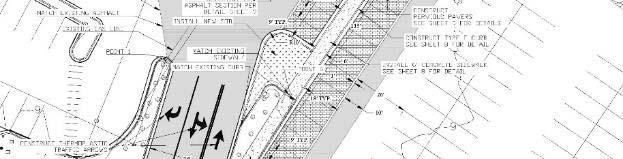
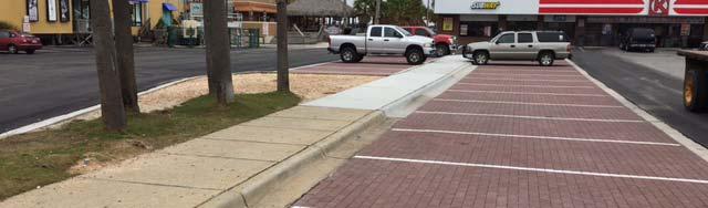
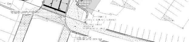
6 Short Term Improvement Projects Ingress/Egress to Circle K Parking Area Design Completed: July 2016 CST Completed: February 2017


7 Short Term Improvement Projects Ingress/Egress to Casino Beach Parking Design Completed: November 2016 CST: March May 2017


8 Short Term Improvement Projects Pedestrian Crosswalk Upgrades Design Completed: November 2016 CST: March May 2017
9 Long Term Congestion Alternatives Consultants were tasked with recommending: Long Term Alternatives at Signalized Intersection (New Signalized Configuration, Roundabouts, Flyover / OverPass, etc.) Analyzing the existing transit operations and options for expansion, modifications, and new opportunities for consideration Evaluating the signal timing i at Fort Pickens and Via De Luna Intersection for optimal traffic management (seasonal timing modifications, time of day plans, etc.) Other improvements projects that would relieve vehicular traffic (e.g. Multi-use paths, Park N Rides, etc.)


10 Long Term Congestion Alternatives Many alternatives considered Public input Operations Safety Roundabouts Consistent Flow Proven Safer Reduces Speeds Fits traffic patterns
11 The image part with relationship ID rid4 was not found in the file. Flounder s Casino Beach Parking SRIA
12
13 The image part with relationship ID rid4 was not found in the file. Alternative B Roundabouts with Elevated Walkways Flounder s SRIA Casino Beach Parking
14 Alternative B Roundabouts with Elevated Walkways
15 The image part with relationship ID rid4 was not found in the file. Alternative C Roundabouts with Pedestrian Underpass Flounder s SRIA Casino Beach Parking
16 Alternative C Roundabouts with Pedestrian Underpass
17 Alternative C Roundabouts with Pedestrian Underpass Approx wide and 50 long
18 Parking & Additional Parking Options Currently, 2,323 approximate public spaces; cannot support the traffic demands during peak times. 1. Public property near fire station along Via DeLuna 2. Public property near sheriff s substation at Casino Beach 3. Public property near Old Visitors Center Building 4. Public property where current office is located Option 1 surface parking Option 2 parking garage
19 Proposed Parking Area Locations
20 SRIA property near fire station along Via DeLuna Provides 167 parking spaces
21 Public property near Sheriff s Substation at Casino Beach Provides 135 parking spaces
22 Old VIC Office Parking Area Provides 16 parking spaces and additional access to existing public parking
23 SRIA Office Site Surface Parking Provides 108 parking spaces
24 SRIA Office Site Parking Garage Provides 368 parking spaces
25 Possible Parking # s Existing Fire Station Casino Beach Old VIC SRIA Site Total 2, * 2,750 2, ** 3,010 * Surface Parking * 15.5% ** Parking Garage ** 22.8%
26 Proposed Transit Improvements Adjust hours of service to better match observed ridership Adjust months of operations to better match peak season Modify schedule and/or alignment to accommodate ferry Split route to improve on-time performance Extend trolley off island
27 Roundabout Alternative Cost Estimates Alternative A = $4,000,000 At Grade Crosswalks Alternative B = $10,000,000 Elevated Walkway Alternative C = $15,000,000 Pedestrian Underpass
28 Transit & Parking Area Cost Estimates Transit = $600,000 Fire Station ti Parking Area = $709, Casino Beach Parking Area = $728,000 Old VIC Office Parking Area = $68,000 (does not consider relocation of building) SRIA Office Parking Area (does not consider SRIA Office) Surface Parking = $459,000 Parking Garage = $5,600,000
29 Pensacola Beach Congestion Management Plan Phasing / Recommendations Phase 1- Ingress/Egress to Circle K / Ingress / Egress to Casino Beach Parking Area / Pedestrian Crosswalk Improvements- Work completed Construction Costs- $554, Completed 5/21/7
30 Phase 2- Additional Parking- Casino Beach Parking Area near Sheriff's Substation / Old Visitors Center / Parking Area Near Fire Station 319 Additional Parking Spaces Estimated Costs Construction Costs- $1,505, Contingencies- $225, CEI- $138, Engineering/Design/Permitting-$198,000 Total- $2,068,141.50
31 Phase 3- Preferred Option- Alternative C- Roundabouts w/ Pedestrian Underpasses Estimated Costs Construction Costs- $11,500, Contingencies- $1,725, CEI- $1,058, Engineering/Design/Permitting-$1,389, g g g, Total- $15,672,000.00
32
33 Past & Future Projects 4-Laning Via DeLuna Pensacola Beach Blvd (SRIA) Access Road 2017/18 Multi-Use Path 1980 s (SRIA) Toll Plaza Upgrades Electronic Tolling Pensacola Bay Ferry Passenger Service 2018
34 Board Recommendation That the Board consider the following two Actions: 1) Accept the Pensacola Beach Congestion Management Plan. 2) Provide input and/or direction to Staff on which plan recommendations to pursue possible funding opportunities for future Board consideration.
Balancing Operation & Safety for Motorized and Non-Motorized Traffic
 Balancing Operation & Safety for Motorized and Non-Motorized Traffic Brian Willham, PE, PTOE Iowa Director - MOVITE June 30, 2014 Learning Objectives: When & Why should we measure the performance of complete
CHIEF PEGUIS TRAIL EXTENSION WEST
 1 PRELIMINARY DESIGN OF THE CHIEF PEGUIS TRAIL EXTENSION WEST Public Information Session June 6, 2017 Welcome 1 Thank you for attending today s public information session. The following boards provide
Feasibility Study of Pedestrian Crossings Along Route 7, East of Cascades Parkway and West of Dranesville Road. October 3, 2017
 Feasibility Study of Pedestrian Crossings Along Route 7, East of Cascades Parkway and West of Dranesville Road October 3, 2017 Study Area (area within a ¼-mile radius of the study intersections) Route
West Village Mobility & Integration
 West Village Mobility & Integration PRESENTED TO TOPCA Town Hall November 9, 2017 [7189-21] Port Credit 2 West Village + Mobility AWalkable Community A CompleteCommunity A SustainableCommunity 3 Mobility
North Shore Transportation Improvement Strategy
 North Shore Transportation Improvement Strategy Preliminary, Near-term Recommendation 2016 April Transportation Improvement Strategy (TIS) Comprehensive and Analytical A multi-modal transportation strategy
Roads and Vehicular Traffic Design Principles. Roads and Vehicular Traffic Recommendations
 CIRCULATION AND PARKING roads and vehicular traffic The Campus Master Plan updates the campus transportation network through a multi-modal approach that encourages walking and biking while improving vehicular
Purpose + Need. Connect: Thrive: Develop: < Strengthen the spine of our regional transportation system
 Purpose + Need I-29 NW Barry Road 64/68/72 MAIN STREET Connect: < Strengthen the spine of our regional transportation system Leavenworth Road Parallel Parkway State Avenue 18th Street Expressway Shawnee
Brian McHugh, Buckhead Community Improvement District. SUBJECT: Wieuca Road at Phipps Boulevard Intersection Improvements Project
 MEMO TO: FROM: Brian McHugh, Buckhead Community Improvement District Jagan Kaja, AICP, WSP Parsons Brinckerhoff SUBJECT: Wieuca Road at Phipps Boulevard Intersection Improvements Project DATE: October
Pattullo Bridge Replacement Project Community Connections Phase 2 Consultation. Appendix 3: Open House Display Boards
 Replacement Project Community Connections Phase 2 Consultation Appendix 3: Open House Display Boards November 2016 Welcome! Welcome to the Replacement Project Public Open House We Want to Hear from You
section 4 Existing Conditions, Issues, and Options
 section 4 Existing Conditions, Issues, and Options 4.0 Existing Conditions, Issues, and Options This section analyzes each segment of the corridor on a street to street basis. Each segment is discussed
WELCOME. Stakeholder Involvement Group Meeting #2 Round Lake Public Works October 24, 2018
 WELCOME Stakeholder Involvement Group Meeting #2 Round Lake Public Works October 24, 2018 MEETING AGENDA 1. Welcome and Introductions 2. Study Progress Update 3. Problem Statement 4. Technical Analysis
6TH AVE N/BENCH BLGS Phase II
 6TH AVE N/BENCH BLGS Phase II Study Objectives Evaluate existing and future traffic conditions on Main Street between Airport Road and 1 st Avenue Determine what, if any design improvements should be considered
Today s Agenda. Welcome & Introductions. I-526 Lowcountry Corridor Update. Table Discussions. Next Steps / Conclusion
 SCDOT Turns 100! SCDOT Turns 100! Today s Agenda Welcome & Introductions I-526 Lowcountry Corridor Update Table Discussions Next Steps / Conclusion Project Limits I-526 Lowcountry Corridor Project Description
List of Display Boards
 List of Display Boards Welcome Introduction Municipal Class Environmental Assessment (EA) Process Need and Justification for an Interchange Alternatives for Evaluation Vertical and Horizontal Alignments
Project Development & Environment (PD&E) Study Public Hearing January 12 th, 2006
 Study Public Hearing January 12 th, 2006") Project Development & Environment (PD&E) Study Public Hearing January 12 th, 2006 Public Hearing Regulations Chapter 23 of United States Code 128 Title 40 of the Code of Federal Regulations Parts 1500
Project Development & Environment (PD&E) Study Public Hearing January 12 th, 2006 Public Hearing Regulations Chapter 23 of United States Code 128 Title 40 of the Code of Federal Regulations Parts 1500
Shockoe Bottom Preliminary Traffic and Parking Analysis
 Shockoe Bottom Preliminary Traffic and Parking Analysis Richmond, Virginia August 14, 2013 Prepared For City of Richmond Department of Public Works Prepared By 1001 Boulders Pkwy Suite 300, Richmond, VA
McGrath Boulevard Project Development Public Meeting #2 May 28 th, 2015 East Somerville Community School
 McGrath Boulevard Project Development Public Meeting #2 May 28 th, 2015 East Somerville Community School Agenda Introductions Project Context Current Construction McGrath Boulevard Project Development
PREPARED TESTIMONY OF NICK CONNOR. Q. Please state your name, professional position, and business address.
 Application 06-12-005 et al. Exhibit Date: August, 2008 PREPARED TESTIMONY OF NICK CONNOR Q. Please state your name, professional position, and business address. A. My name is Nick Connor. I presently
Los Altos Hills Town Council - June 18, 2015 Palo Alto City Council June 22, AGENDA ITEM #2.B Presentation
 Los Altos Hills Town Council - June 18, 2015 Palo Alto City Council June 22, 2015 AGENDA ITEM #2.B Presentation Previous Presentations Los Altos Hills Town Council in May 2014 and February 2015 Palo Alto
Princeton Avenue and Spruce Street Transportation and Site Access Enhancements Project
 Princeton Avenue and Spruce Street Transportation and Site Access Enhancements Project Mercer County Planning Division AECOM Transportation (formerly DMJM Harris) January 29, 2009 Agenda Project Status
Dr. Naveed Anwar Executive Director, AIT Consulting Affiliated Faculty, Structural Engineering Director, ACECOMS
 Dr. Naveed Anwar Executive Director, AIT Consulting Affiliated Faculty, Structural Engineering Director, ACECOMS Overview Highway Functions and Classifications Highway Design Components Design Control
MEMORANDUM INTRODUCTION/PURPOSE/OVERALL FINDINGS
 MEMORANDUM Date: To: From: Subject: Steve, City of Tacoma Dan Grayuski and Will Lisska, Fehr & Peers Schuster Corridor Trail Project SE12-0265.00 INTRODUCTION/PURPOSE/OVERALL FINDINGS The City of Tacoma
Main-McVay Transit Study: Phase 2 Options Definition and High Level Constraints Evaluation
 Main-McVay Transit Study: Phase 2 Options Definition and High Level Constraints Evaluation APRIL 2016 A collaborative study between: For Additional Information or to Comment If you would like additional
US 278 Corridor Concept Presentation. Avondale Estates Intersection Improvement/Roundabout and Road Diet Feasibility Study March 19, 2015
 US 278 Corridor Concept Presentation Avondale Estates Intersection Improvement/Roundabout and Road Diet Feasibility Study March 19, 2015 Thanks to our Partners Atlanta Regional Commission Georgia Department
Rethinking Transportation
 Rethinking Transportation We have some innovative ideas about a local transportation sharing network. car share and a bike share could mean that future residents would not need to own either a car or a
Transportation 6. A. Transit Center Circulation and Access. 1. Transit Center Circulation
 Transportation 6 This chapter describes the transportation system in and around the Hillsdale Station Area, with a focus on the Transit Center at the relocated Hillsdale Caltrain Station. The transportation
Grade Separated Intersection
 Grade Separated Intersection Lecture Notes in Transportation Systems Engineering Prof. Tom V. Mathew Contents 1 Overview 1 2 Classification of Intersection 2 2.1 Grade Separated Intersection...........................
APPENDIX D. May 22, 2002 Open House Summary and Materials
 APPENDIX D May 22, 2002 Open House Summary and Materials TH 36 Partnership Study Open House May 22, 2002 Summary of Survey Responses 1. If no new crossing of the St. Croix River is built (e.g. the existing
Pine Hills Road Pedestrian/Bicycle Safety Study Board of County Commissioners Work Session
 Pine Hills Road Pedestrian/Bicycle Safety Study Board of County Commissioners Work Session February 20, 2018 Meeting Agenda Study Overview Existing Conditions Access Management Potential Gateway Features
Appendix B. Environmental Resource Technical Memorandum. Assessment on Travel Pattern and Access Impacts
 Appendix B Environmental Resource Technical Memorandum Assessment on Travel Pattern and Access Impacts TECHNICAL MEMORANDUM ENVIRONMENTAL RE-EVALUATION FOR UNION STATION TO OAK CLIFF DALLAS STREETCAR To:
The five potential solutions and some of their benefits and costs are listed in the following table: Ferry Patron Bike Parking Alternatives
 STAFF REPORT City Council of the City of Sausalito AGENDA TITLE: Ferry Patron Bicycle Parking Plan - Summer 2014 RECOMMENDED MOTION: Note and file informational item, no action necessary SUMMARY In April
PEDESTRIAN ACCOMMODATIONS DPS 201 AT INTERCHANGES
 PEDESTRIAN ACCOMMODATIONS DPS 201 AT INTERCHANGES UNDERSTANDING THE ISSUES Intersections of freeway ramp terminals at crossroads are the most critical components of an interchange Challenge: balance mobility
Frequently Asked Questions (FAQ)
") Frequently Asked s (FAQ) Study Process... 2 Rapid Transit Service and Operations... 5 Public Consultation... 8 Business Impacts... 8 Design and Property Impacts... 9 Construction Impacts...12 Traffic,
Frequently Asked s (FAQ) Study Process... 2 Rapid Transit Service and Operations... 5 Public Consultation... 8 Business Impacts... 8 Design and Property Impacts... 9 Construction Impacts...12 Traffic,
Virginia Street Bus RAPID Transit Extension Project. Environmental Assessment (EA) Presentation Public Hearing June 22, 2017
 Presentation Public Hearing June 22, 2017") Virginia Street Bus RAPID Transit Extension Project Environmental Assessment (EA) Presentation Public Hearing June 22, 2017 Presentation to RTC July 17, 2015 Presentation Overview Project Timeline Environmental
Virginia Street Bus RAPID Transit Extension Project Environmental Assessment (EA) Presentation Public Hearing June 22, 2017 Presentation to RTC July 17, 2015 Presentation Overview Project Timeline Environmental
72 Avenue Four Laning (BNSF Overpass to 120 Street) WELCOME. Public Information Meeting
 WELCOME. Public Information Meeting") 72 Avenue Four Laning (BNSF Overpass to 120 Street) WELCOME Public Information Meeting Project Goals About the Project The goal of this project is to address congestion along 72 Avenue and adjacent streets
72 Avenue Four Laning (BNSF Overpass to 120 Street) WELCOME Public Information Meeting Project Goals About the Project The goal of this project is to address congestion along 72 Avenue and adjacent streets
Summary: Mercer County Princeton Avenue & Spruce Street Study January 2009
 Summary: Several recent studies have assessed potential development and redevelopment opportunities in the Mercer Crossing area of Trenton, Ewing, and Lawrence. This Princeton Avenue and Spruce Street
TRANSPORTATION & MOBILITY
 TRANSPORTATION & MOBILITY ROADWAY SYSTEM There are approximately 40 miles of roadways in Manitou Springs. For planning purposes, roadways are typically assigned a functional classification which defines
MCA Member Meeting: Tysons Update. Fairfax County Department of Transportation November 13, 2017
 MCA Member Meeting: Tysons Update Fairfax County Department of Transportation November 13, 2017 Presentation Overview Balancing Land Use and Transportation How Are We Doing? Studies and Projects Neighborhood
Harrah s Station Square Casino
 Transportation Analysis Harrah s Station Square Casino Pittsburgh, Pennsylvania Submitted To: City of Pittsburgh and Pennsylvania Gaming Control Board Prepared By: DKS Associates GAI Consultants December
APPENDIX I TRANSIT TRAVEL TIME SAVINGS
 APPENDIX I TRANSIT TRAVEL TIME SAVINGS McCORMICK RANKIN CORPORATION 1145 Hunt Club Road, suite 300 Ottawa, Ontario, K1V 0Y3 Tel: (613)736-7200 Fax: (613) 736-8710 E-mail: mrc@mrc.ca Website: www.mrc.ca
Welcome. Thank you for your interest in the Lewis & Clark Viaduct Concept Study
 Welcome Thank you for your interest in the Lewis & Clark Viaduct Concept Study Please use the arrows in the upper left hand corner to navigate through the presentation. Use the envelope icon to ask a question
Malabar Road (SR 514) PD&E. Town of Malabar Briefing (July 17, 2017)
 PD&E. Town of Malabar Briefing (July 17, 2017)") Malabar Road (SR 514) PD&E Town of Malabar Briefing (July 17, 2017) 1 Agenda Project limits and briefing focus PD&E process and project status Public and agency project comments Review Recommended Alternatives:
Malabar Road (SR 514) PD&E Town of Malabar Briefing (July 17, 2017) 1 Agenda Project limits and briefing focus PD&E process and project status Public and agency project comments Review Recommended Alternatives:
RM 620/RM 2222 CONNECTOR (BYPASS) STATUS REPORT RM 620/2222 STATUS
 STATUS REPORT RM 620/2222 STATUS") RM 620/RM 2222 CONNECTOR (BYPASS) STATUS REPORT January 25, 2017 RM 620/2222 BYPASS - INTRODUCTION Because of the enormous traffic demand at the RM 620/2222 intersection, TxDOT searched for a way to relieve
RM 620/RM 2222 CONNECTOR (BYPASS) STATUS REPORT January 25, 2017 RM 620/2222 BYPASS - INTRODUCTION Because of the enormous traffic demand at the RM 620/2222 intersection, TxDOT searched for a way to relieve
5. RUNNINGWAY GUIDELINES
 5. RUNNINGWAY GUIDELINES These guidelines should be considered collectively when making runningway decisions. A runningway is the linear component of the transit system that forms the right-of-way reserved
Meeting Summary Public Information Meeting #1 Warren County Pathway Corridor Project September 27, 2018
 Meeting Summary Public Information Meeting #1 Warren County Pathway Corridor Project September 27, 2018 The first public information meeting for the Warren County Pathway Corridor Project was held on Thursday,
to the Public Information Centre for the Downtown Traffic Study
 to the Public Information Centre for the Downtown Traffic Study City of Sault Ste. Marie July 25, 2018 Purpose of Study Determine if changes to one-way corridors can enhance downtown s character and spaces
Report Purpose To seek Council s approval of the Wye Road Functional Planning Study (January 2015).
.") COUNCIL MEETING Meeting Date: March 10, 2015 Agenda Item #: 13.1 Wye Road Functional Planning Study (January 2015) Report Purpose To seek Council s approval of the Wye Road Functional Planning Study (January
COUNCIL MEETING Meeting Date: March 10, 2015 Agenda Item #: 13.1 Wye Road Functional Planning Study (January 2015) Report Purpose To seek Council s approval of the Wye Road Functional Planning Study (January
Environmental Assessment Findings & Recommendations. Public Hearing November 13, 2014
 Environmental Assessment Findings & Recommendations Public Hearing November 13, 2014 Welcome! Welcome and Introductions Project and Environmental Assessment Overview Public Comments Adjourn Purpose of
Approximately 360 trail users cross during a typical summer weekday and 420 cross during a typical summer
 5. PARKR ROAD AT MISSISSIPPI AVN CROSSIN xisting Conditions The High ine Canal trail crosses Parker Road near the Mississippi Avenue intersection (crossing location #3 on Figure 1). South of Parker, the
AGENDA ITEM G-2 Public Works
 AGENDA ITEM G-2 Public Works STAFF REPORT City Council Meeting Date: 12/6/2016 Staff Report Number: 16-214-CC Regular Business: Approve the Oak Grove University Crane Bike Improvement Concept Plan, authorize
15 April CAMPUS MASTER PLAN UPATE F o c us G r o up M o b ility
 15 April 2016 CAMPUS MASTER PLAN UPATE F o c us G r o up M o b ility AGENDA What We Heard Campus Framework & Open Space Network Mobility Approach Supporting the Pedestrian Environment Mobility & Sustainability
Ballston Station Multimodal Study WMATA and Arlington County. Meeting Minutes
 Date of Meeting: June 10, 2010 Location: Ballston Metrorail Station and NRECA Building 4301 Wilson Blvd, Arlington, VA Subject: Ballston Station Multimodal Study Stakeholder Meeting #1 Summary: This first
Public Information Meeting. Orange Camp Road. Dr. Martin Luther King Jr. Beltway to I-4. Presented by: Volusia County August 2, 2018
 Public Information Meeting Orange Camp Road Dr. Martin Luther King Jr. Beltway to I-4 Presented by: Volusia County August 2, 2018 1 Project Goals To improve the operations and safety for Orange Camp Road
Casablanca Boulevard & GO Station Access
 Casablanca Boulevard & GO Station Access Class Environmental Assessment STAKEHOLDER WORKSHOP Thursday September 27th, 2018 5:30PM 8:00PM 1 WORKSHOP PURPOSE Provide an overview of the Design Alternatives
ELEMENT 11 TRANSPORTATION ELEMENT
 ELEMENT 11 TRANSPORTATION ELEMENT TRANSIT, CIRCULATION, PARKING, PEDESTRIAN, & NON-VEHICULAR CIRCULATION Introduction The following narrative describes the concepts on which the transportation plan is
Memorandum. Sunday, July 13, Saturday, July 19, 2014
 Memorandum To: David Lowin, Brooklyn Bridge Park Corporation From: Daniel Schack, AICP, PTP Date: Re: Brooklyn Bridge Park Pier 5/6 Loop Road Traffic Study Project No: 14-01-2407 At the request of Brooklyn
CONNECTED VEHICLE PILOT DEPLOYMENT PROGRAM
 CONNECTED VEHICLE PILOT DEPLOYMENT PROGRAM August 2, 2016 Presentation Concept Pilot Location Deployment Characteristics Use Cases Application Overview 2 Concept Demonstrate and measure the impact of Connected
Niantic Center Elementary School
 Niantic Elementary School is located in the Northwest corner of the intersection of West Main Street and East Pattagansett Road, as so noted on the Facility Location Map. location Overview: The site is
Chapter 33. Grade Separated Intersection Overview Classification of Intersection Grade Separated Intersection
 Chapter 33 Grade Separated Intersection 33.1 Overview An intersection is the area shared by the joining or crossing of two or more roads. Since the main function of an intersection is to enable the road
Existing Transportation System
 < Open for Additional Text Transportation System Existing Transportation System This section describes vehicular transportation associated with Children s. transportation are described in a separate section
ROADSOADS CONGESTION HAMPTON SYSTEMYSTEM MANAGEMENT. Part II Roadway Congestion Analysis Mitigation Strategies and Evaluation
 HAMPTON ROADSOADS CONGESTION MANAGEMENT SYSTEMYSTEM Part II Roadway Congestion Analysis Mitigation Strategies and Evaluation Presented by: Dwight Farmer, PE Deputy Executive Director, Transportation April
S T A T I O N A R E A P L A N
 The Circulation and Access Plan describes vehicle, pedestrian, and transit improvements recommended within the Concept Plan. In order to create and sustain a vibrant business district that provides pedestrian-friendly
DRAFT BUENA VISTA 2020 TRANSPORTATION PLAN
 DRAFT BUENA VISTA 2020 TRANSPORTATION PLAN DEVELOPED BY THE TRANSPORTATION PLANNING DIVISION OF THE VIRGINIA DEPARTMENT OF TRANSPORTATION IN COOPERATION WITH THE U.S. DEPARTMENT OF TRANSPORTATION, FEDERAL
Paoli Road Improvement Feasibility Study
 Paoli Road Improvement Feasibility Study & Public Participation Project March 24, 2015 Prepared for: Tredyffrin Township Prepared by: McMahon Associates, Inc. with Town Planning Partnership, LLC Glackin
Chapter 5 Future Transportation
 Chapter 5 Future Transportation The Future Land Use Plan identifies the desired land use designations. The land uses desired for Crozet depend, in large part, on the success of the transportation system,
CHAPTER 16 PEDESTRIAN FACILITIES DESIGN AND TECHNICAL CRITERIA TABLE OF CONTENTS
 CHAPTER 16 PEDESTRIAN FACILITIES DESIGN AND TECHNICAL CRITERIA TABLE OF CONTENTS Section Title Page 16.1 General... 16-1 16.1.1 AASHTO Reference... 16-1 16.1.2 ADA Requirements... 16-1 16.2 Sidewalks...
Norfolk Tide LRT System Weaving Transit in Downtown Norfolk
 Rail-Volution 2010 Weaving Transit into Existing Communities Norfolk Tide LRT System Weaving Transit in Downtown Norfolk Dan Meyers, AICP URS, Planning Manager Minneapolis, Minnesota Norfolk Tide LRT Alignment
6.4 RECOMMENDED IMPROVEMENTS
 6.4 RECOMMENDED IMPROVEMENTS 6.4.1 Williston Road Recommendations While all alternatives would be an improvement over existing conditions, Alternative 3B is recommended over the others because it provides
State Road 54/56 Tampa Bay s Northern Loop. The Managed Lane Solution Linking I-75 to the Suncoast Parkway
 State Road 54/56 Tampa Bay s Northern Loop The Managed Lane Solution Linking I-75 to the Suncoast Parkway SUNCOAST PARKWAY Both I 75 and the Suncoast Parkway are planning, or in the process of constructing,
PRESENTATION OUTLINE
 November 8, 2017 PRESENTATION OUTLINE Regional Express Lanes Network Purpose/Benefits of Express Lanes 95 Express Phase 3C Project Video and Overview 95 Express Phase 3C Schedule 2 SOUTH FLORIDA REGIONAL
University Hill Transportation Study Technical Memorandum Alternatives Modeling and Analysis May 2007
 Technical Memorandum May 2007 Syracuse Metropolitan Transportation Council Edwards and Kelcey with Wallace Roberts and Todd Alta Planning and Design CONTENTS SECTION ONE- INTRODUCTION...1 SECTION TWO-
See Figure 38, Existing Nonmotorized Connections.
 Nonmotorized Connections Existing Nonmotorized Connections Pedestrian, vehicle and bike traffic access and movements are confined primarily to Penny Drive on campus. Due to the steep slope along the length
Elmhurst Metra Station. Public Hearing Wednesday - November 30, 2016
 Elmhurst Metra Station Public Hearing Wednesday - November 30, 2016 Agenda Introduction to Hearing Format - Presentation (20 Minutes) - Exhibits/Workstations - Record (Comment Cards, Court Reporter)
Kennedy Plaza and Providence Downtown Transit Connector PUBLIC MEETING. Stakeholder Meeting #1 October 24, 2016
 Kennedy Plaza and Providence Downtown Transit Connector PUBLIC MEETING Stakeholder Meeting #1 October 24, 2016 May 2017 1 WHAT IS THE DTC? 1.5 mile corridor between Providence Station and the Hospital
Following are our comments and findings based on the site visit and review of the complete Traffic Impact Study:
 3600 Horizon Boulevard Suite 250 Trevose, Pennsylvania 19053-4900 Voice 215.355.3577 Fax 215.355.3147 www.ekcorp.com November 1, 2006 Pennsylvania Department of Transportation Bureau of Highway Safety
8 PROPOSED ROUNDABOUT DUFFERIN STREET AND KING VAUGHAN ROAD INTERSECTION CITY OF VAUGHAN
 8 PROPOSED ROUNDABOUT DUFFERIN STREET AND KING VAUGHAN ROAD INTERSECTION CITY OF VAUGHAN The Transportation Services Committee recommends the adoption of the recommendation contained in the following report
Downtown Naples Mobility and Connectivity Study. Naples City Council Presentation January 2017
 Downtown Naples Mobility and Connectivity Study Naples City Council Presentation January 2017 Agenda 1. Introduction 2. Scope Review 3. Project Schedule 4. Existing Conditions 5. Public Charrette 6. Mobility
City of Gainesville Transportation/Roadway Needs PROJECT SUMMARY
 A1 Roadway Resurfacing $23,846,000 TYPE: Preservation of existing system Roadway resurfacing A2 Signal Replacement $6,000,000 TYPE: Preservation of existing system Replace traffic signals. B1 W 6th St
I-90 ALLSTON INTERCHANGE A MULTIMODAL TRANSPORTATION PROJECT MEPA CONSULTATION MEETING NOVEMBER 20, 2014 BRIGHTON HIGH SCHOOL
 I-90 ALLSTON INTERCHANGE A MULTIMODAL TRANSPORTATION PROJECT MEPA CONSULTATION MEETING NOVEMBER 20, 2014 BRIGHTON HIGH SCHOOL Today s Agenda 1. 2. 3. 4. 5. Overview of the MEPA Process Project Overview
TRANSPORTATION & MOBILITY VISIONING MEETING. August 23 24, 2017
 TRANSPORTATION & MOBILITY VISIONING MEETING August 23 24, 2017 Project Team 1999 South Lakefront Framework Plan In 1999, the Chicago Park District authorized framework plans for three historic parks: Jackson,
PROPOSAL: Review of Alaska DOT&PF project 68471, Glacier Highway reconstruction and pedestrian improvements from
 PROPOSAL: Review of Alaska DOT&PF project 68471, Glacier Highway reconstruction and pedestrian improvements from Fritz Cove Rd to Seaview Ave, for consistency with locally adopted plans and ordinances.
Display Boards Including Five Refined Design Concepts
 APPENDIX D Workshop Session 3 Sign-in sheets Agenda Booklet Display Boards Including Five Refined Design Concepts PowerPoint Presentation Questions Recorded Discussion of Preference Exercise AGENDA
EXECUTIVE SUMMARY. Vision
 Vision Walking and bicycling in Salt Lake City will be safe, convenient, comfortable, and viable transportation options that connect people to places, foster recreational and economic development opportunities,
SR 693 (Pasadena Avenue) Corridor Study from Shore Drive South to 66 th Street
 Corridor Study from Shore Drive South to 66 th Street") Welcome and Introduction Sign-in and comment sheets Restrooms and exits Meeting agenda and timeline Meeting goals / expectations Provide input to guide study recommendations Actively participate throughout
Welcome and Introduction Sign-in and comment sheets Restrooms and exits Meeting agenda and timeline Meeting goals / expectations Provide input to guide study recommendations Actively participate throughout
Huntington Station Metro Zone / North Kings Highway Concept Plan
 Summary Narrative of Huntington Station Metro Zone / North Kings Highway Concept Plan Located in Fairfax County, Virginia prepared for A.J. Dwoskin & Associates, Inc.. 9302 Lee Highway, Suite 300 Fairfax,
MORRISVILLE TRANSPORTATION PLAN TOWN COUNCIL WORK SESSION AUGUST 8, 2017
 TOWN COUNCIL WORK SESSION AUGUST 8, 2017 ENGAGEMENT SUMMARY OPEN HOUSE #2 OPEN HOUSE #2 31 ATTENDEES! TRANSPORTATION RECOMMENDATIONS 2040 E+C MODELED CONGESTION Committed Projects Aviation Parkway Widening
Transportation Investment Act Gwinnett County. Charlotte J. Nash, Chairman Gwinnett County Board of Commissioners
 Transportation Investment Act Gwinnett County Charlotte J. Nash, Chairman Gwinnett County Board of Commissioners April 25, 2012 Transportation Investment Act Gwinnett County Gwinnett County Transportation
INTRODUCTION THOROUGHFARE SYSTEM CLASSIFICATIONS
 INTRODUCTION The thoroughfare plan will assist public officials in the development of a specialized system for efficient and safe movement of vehicular traffic while minimizing potential conflicts with
CTH M Reconstruction
 CTH M Reconstruction ID 5992 09 81 City of Madison, South Pleasant View Road (Cross Country Road Prairie Hill Road) CTH M Dane County Public Information Meeting Thursday, May 24, 2012 6 p.m. to 8 p.m.
BETHEL ROAD AND SEDGWICK ROAD CORRIDOR STUDY
 DRAFT PLAN City Council Meeting August 14, 2017 STUDY AREA Sedgwick Corridor State Route 160, principal arterial with Class 3 access management designation, commuter and freight route, connection to SR
Project Description Form 8EE
 Project Description Form 8EE Basic Project Information Submitting Jurisdiction/Agency: Town of Dumfries Project Title: Route 1 (Fraley Blvd) Widening: Brady's Hill Road to Dumfries Road Project Location:
I 10 Phoenix to California Border Multimodal Corridor Profile Study
 I 10 Phoenix to California Border Multimodal Corridor Profile Study December 2012 Prepared by Arizona Department of Transportation 206 S. 17th Ave. Phoenix, AZ 85007 In cooperation with U.S. Department
Roosevelt Estates Neighborhood Improvements
 Roosevelt Estates Neighborhood Improvements Transportation Alternatives Application May 5 th, 2016 Qualifying Activities Construction of on-road and off-road trail facilities for pedestrians, bicyclists,
Hennepin/First Transportation Study
 CITY OF MINNEAPOLIS Hennepin/First Transportation Study NIEBNA Board Meeting November 10, 2016 11/10/2016 1 Study Overview Evaluate transportation system and alternatives Coordinate with County, Metro
2011 Capital Projects University Area - Community Council Priority List Municipality of Anchorage
 2011 Capital Projects University Area - Community Council Priority List Municipality of Anchorage 2 Project Management and Engineering Projects on 40th Ave Extension - Lake Otis Pkwy to Dale St $18,103,000
Chapter 4: Transportation Systems
 4.1 INTRODUCTION This chapter evaluates the transportation benefits and impacts of the Preferred Alternative on the existing transportation system (No Action Alternative). Table 4 1 summarizes the transportation
A Case Study in Innovation 26 Avenue Roundabout
 A Case Study in Innovation 26 Avenue Roundabout Glen Furtado, M.A.Sc., P.Eng., Urban Systems Ltd. Chris Ollenberger, P.Eng., Calgary Municipal Land Corporation Paper prepared for presentation at the 2010
4. Action Plan & Projects
 4. Action Plan & Projects 45 46 ACTION PLAN AND PROJECTS The Action Plan organizes the list of transportation projects described in the Mobility Framework Plan section into short-term (0-5 years) and long-term
COWETA HIGH SCHOOL AND EAST HIGHWAY 51
 COWETA HIGH SCHOOL AND EAST HIGHWAY 51 Lack of sidewalks along Ben Lumpkin Rd. Lack of crosswalks and ramps at intersection. Hwy 51 is wide to cross as a pedestrian. No ADA compliance or connection to
Transportation Feasibility Study
 Transportation Feasibility Study Redevelopment of the Naval Air Station Brunswick (NASB) Prepared for Prepared by Bedford, New Hampshire In partnership with Office of the Governor Maine Office of Redevelopment