FINAL MCDONALD ROAD SIDEWALK FEASIBILITY STUDY
|
|
|
- Rudolf Bryan
- 5 years ago
- Views:
Transcription


1 FINAL MCDONALD ROAD SIDEWALK FEASIBILITY STUDY APRIL 2015 Prepared For: Prepared By:
2 CONTENTS 1 EXECUTIVE SUMMARY INTRODUCTION... 5 PURPOSE AND OBJECTIVES... 5 CITY OF PORT ORANGE... 7 PROJECT HISTORY STUDY METHODOLOGY AND DESIGN PRINCIPLES... 8 ORIGINAL STUDY METHODOLOGY... 8 REVISED STUDY METHODOLOGY... 9 GENERAL DESIGN PRINCIPLES EXISTING CONDITIONS INTERSECTION WITH SAULS STREET/SUGAR HOUSE DRIVE INTERSECTION WITH CHRISTY DRIVE INTERSECTION WITH CHARLES STREET EXISTING DRAINAGE CROSSING UNDER MCDONALD ROAD INTERSECTION WITH 6TH STREET CONCEPTUAL DESIGN RECOMMENDATIONS CORRIDOR RECOMMENDATIONS LOCATION SPECIFIC RECOMMENDATIONS FINANCIAL FEASIBILITY CONCLUSION AND SUMMARY OF RECOMMENDATIONS DATA COLLECTION REFERENCES TABLES Table 1 Engineer s Estimate Opinion of Probable Costs...21 McDonald Road Sidewalk Feasibility Study April 2015 Kimley-Horn and Associates, Inc. 2
3 FIGURES Figure 1 Location Map...6 APPENDICES Appendix A Sugar Mill Elementary School Safe Routes to School Study Excerpts Appendix B - Existing Corridor Photos Appendix C - Conceptual Design Plans Appendix D - Response to FDOT Comments Appendix E - FDOT Right of Way Acquisition Reference Material McDonald Road Sidewalk Feasibility Study April 2015 Kimley-Horn and Associates, Inc. 3
4 1 EXECUTIVE SUMMARY The River to Sea Transportation Planning Organization (R2CTPO) recognizes the importance of developing a cohesive transportation network that provides safe, efficient, and accessible pedestrian and bicycle facilities. One way to accomplish this goal is to expand the integrated bicycle and pedestrian transportation system by continuing the feasibility studies of prioritized projects. The McDonald Road Sidewalk Feasibility Study is a R2CTPO 2011 prioritized XU Bicycle/Pedestrian project as requested by the City of Port Orange, Volusia County, Florida. The purpose of this project was to conduct a limited corridor study that assesses the feasibility of providing a minimum five (5) foot wide sidewalk along the west side of McDonald Road extending approximately 2,640 feet from the intersection of Madeline Avenue and Sugarhouse Drive through the intersection of Sauls Street/Madeline Avenue to 6 th Street. The objective of the project was to identify the width of the path and its location in an effort to design a costeffective path that fits within the existing right-of-way. This project was identified as a needed project in the Sugar Mill Elementary School Safe Routes to School Study conducted in 2007 for increasing safety to and from the school. The City Council approved submittal of this project to the R2CTPO as part of the call for 2011 prioritized XU Bicycle/Pedestrian projects. The City has also received a letter of support from the Principal of Sugar Mill Elementary School. A feasibility study was previously completed in February However, in April 2014, FDOT issued comments on the previously finalized study. In order to address FDOT s comments, new field investigations were completed, and the study was updated to incorporate current features and design recommendations. This project will provide a safer pedestrian and bicycle route on the west side of McDonald Road, particularly for school children who cross the street to access the residential developments on the west side. The sidewalk will provide a formal route to direct children to the crosswalks and is expected to be constructed within the existing apparent right-of-way (ROW), with one possible exception. Coordination efforts are recommended with this property owner, to enhance the effectiveness of the sidewalk through these limits. This report contains the recommended conceptual alignment for the study corridors, as well as a planning level estimate of the anticipated costs associated with the recommended improvements. It is noted that a corridor specific survey should be conducted prior to development of a sidewalk design and engineering drawings. In addition, no drainage permitting is anticipated to be required; however, coordination with St. Johns River Water Management District will be necessary to obtain an exemption verification letter. McDonald Road Sidewalk Feasibility Study April 2015 Kimley-Horn and Associates, Inc. 4

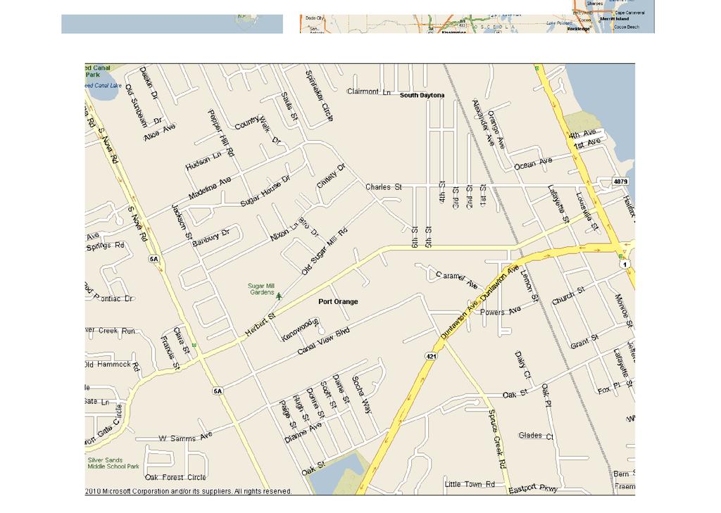
5 2 INTRODUCTION The River to Sea Transportation Planning Organization (R2CTPO) recognizes the importance of developing a cohesive transportation network that provides safe, efficient, and accessible pedestrian and bicycle facilities. One way to accomplish this goal is to expand the integrated bicycle and pedestrian transportation system by continuing the feasibility studies of prioritized projects. The McDonald Road Sidewalk Feasibility Study was identified as a R2CTPO (formerly the Volusia Transportation Planning Organization) 2011 prioritized XU Bicycle/Pedestrian project as requested by the City of Port Orange, Volusia County, Florida. PURPOSE AND OBJECTIVES The purpose of this project is to conduct a limited corridor study that will assess the feasibility of providing a minimum five (5) foot wide sidewalk along the west side of McDonald Road extending approximately 2,640 feet from the intersection of Madeline Avenue and Sugarhouse Drive through the intersection of Sauls Street/Madeline Avenue to 6th Street. A location map is included as Figure 1. The objective of the project is to identify the width of the path and its location in an effort to design a cost-effective path that fits within the existing right-of-way. The proposed sidewalk is located near many community facilities including Sugar Mill Elementary School and the Sugar Mill Botanical Gardens. An eight foot wide sidewalk now exists on the east side of McDonald Road adjacent to, and leading from, the elementary school property. Most of the students within the walk zone are living to the west of the school and are using roadways with one sidewalk or no sidewalks. It has been recommended that since the majority McDonald Road East Side Existing of students who walk or ride bicycles live west of the school site, there should be sidewalks along the west side of McDonald Road. This would encourage students to cross the roadway where a crossing guard or cross walk is located. Many children and parents with children cross McDonald Road near Christy Drive to directly access the school through the side gate to the bicycle rack area. This is not a marked crossing and there is no crossing guard. Currently there is a crossing guard stationed at the intersection of Charles Street and McDonald Road as well as at the T-Intersection of Madeline Avenue/Saul Street and McDonald Road. McDonald Road Sidewalk Feasibility Study April 2015 Kimley-Horn and Associates, Inc. 5


6 6
7 CITY OF PORT ORANGE The City of Port Orange was incorporated in 1926 in Volusia County and consists of 28 square miles with a population of approximately 56,067 people. Port Orange is one of the major urban areas within the county and according to the city web page, it contains 150 distinct neighborhoods. The City of Port Orange is a Local Agency Program (LAP) certified agency. This project was identified as a need in the Sugar Mill Elementary School Safe Routes to School Study conducted in 2007 for increasing safety to and from the school. Excerpts from the Study are included in Appendix A. The City Council approved submittal of this project to the R2CTPO as part of the call for 2011 prioritized XU Bicycle/Pedestrian projects. The City has also received a letter of support from the Principal of Sugar Mill Elementary School. The City s support for pedestrian safety and facilities is evident in their Comprehensive Plan. The City s Transportation Element and Future Land Use Element include policies to develop a complete streets strategy to include multiple transportation modes into proposed plans for road improvements and to expand transportation choices by ensuring an efficient network of roads, sidewalks, and bike paths that are safe for pedestrians, bicyclists and vehicular traffic. The City requested the following considerations as part of the feasibility project: Up to two cross walks at locations determined by the feasibility study from the west side of McDonald Road to the existing 8 foot sidewalk on the east side; Realignment of the existing crosswalk at the intersection of McDonald Road and Charles Street as recommended by the Sugar Mill Elementary School Assessment Report (March 2007); Two drainage structure crossings requiring engineering review and recommendation in order to provide a structure conducive to both pedestrian safety and stormwater drainage; Safety barrier improvements along Madeline Avenue from Saul to Sugarhouse Drive; Intersection improvements at Madeline Avenue/Saul Street and McDonald Road. PROJECT HISTORY A feasibility study was conducted in 2012, with a Draft Report prepared in December Comments were received from the City of Port Orange, and the TPO, and the study was finalized in February In April 2014, FDOT issued comments on the previously finalized study. In order to address FDOT s comments and move forward with the project, the R2CTPO decided to update the study to incorporate FDOT s concerns. Additional field investigations were conducted in January 2015 and the original study recommendations were reviewed and updated. The revised conceptual alignment is presented in this study. McDonald Road Sidewalk Feasibility Study April 2015 Kimley-Horn and Associates, Inc. 7
8 3 STUDY METHODOLOGY AND DESIGN PRINCIPLES ORIGINAL STUDY METHODOLOGY For the study completed in 2013, the following tasks were completed per the project scope to provide an informed feasibility report in accordance with R2CTPO policies, procedures, guidelines and rules. 1. A project coordination meeting was held with the R2CTPO s Project Manager and the City of Port Orange representatives on September 26, 2012 for the purpose of scoping the project and obtaining relevant project information. 2. Data collection for the project consisted of obtaining copies of readily available planning, land use, and engineering information, including the following: a. City of Port Orange, as-built drawings for Amber Woods from Ashley Ct. to 6 th Street (West side). Right-of-way and as-built for McDonald Road sidewalk in Amber Village SD. b. City of Port Orange, Amber Village Plat, January c. City of Port Orange, Plantation Acres Plat, February d. City of Port Orange, Map of Dun-Lawton, January e. City of Port Orange, LIDAR. f. City of Port Orange McDonald Road specific purpose survey, January g. Volusia County Property Appraisers parcel maps were downloaded to further delineate the area. This information serves as the most current apparent right of way data available at the time of this evaluation. All measurements are assumed and for planning purposes only. h. Data also consisted of referencing readily available information from a variety of sources, including: R2CTPO, Volusia County, City of Port Orange, and FDOT. 3. Site visits were conducted on September 26, 2012 and November 14, 2012 which consisted of traversing the project corridor in order to document the current constraints and opportunities within the apparent right of way. Photographic documentation, graphic depiction and measurements, and aerial maps assisted in recording the important details of the project and to note obstacles that might impede the project s constructability. Members of the evaluation team collected information on field conditions and located potential constraints and opportunities associated with the proposed project. 4. A concept plan and typical cross sections were formulated based on the results of the previous tasks and applicable design guidelines. The concept plan and the typical section are based on design criteria for pedestrian facilities contained in the Florida Department of Transportation (FDOT) Pedestrian Facilities Planning and Design McDonald Road Sidewalk Feasibility Study April 2015 Kimley-Horn and Associates, Inc. 8
9 Handbook; the FDOT Plans Preparation Manual (PPM); and the Manual on Uniform Minimum Standards for Design, Construction and Maintenance for Streets and Highways, The Florida Greenbook. In accordance with these reference manuals, a feasible design for the project was determined. 5. An Engineer s Opinion of Probable Costs (EOPC) for Construction based on the refined conceptual design was prepared to construct a sidewalk within the proposed corridor. The EOPC was formulated based on FDOT District Five standards using their historical cost data. 6. Preparation of a Final Report followed receipt of comments by the R2CTPO, the FDOT, and the City. REVISED STUDY METHODOLOGY Because of the length of time between the finalization of the study and the comments provided by FDOT, a complete review of the study was warranted. In order to update the study, the following tasks were completed: 1. A project coordination conference call was held with the R2CTPO s Project Manager, FDOT representatives, and the City of Port Orange representatives on November 19, 2014, for the purpose of scoping the project and obtaining relevant project information. 2. A site visit was conducted on January 27, 2015, to verify existing conditions along the project corridor and review the specific locations. 3. Additional data collection consisted of updating the information previously obtained for the corridor. 4. The FDOT comments were reviewed in conjunction with the conceptual design. Adjustments were made to the alignment to reflect existing conditions and to address FDOT s concerns with the previous alignment. 5. The OPC was updated with current historical costs, pay item numbers, and inflation factors 6. The Report was updated to include the revised analysis and conceptual plan. GENERAL DESIGN PRINCIPLES The concept plan and typical cross sections included within this report were formulated based on the results of compiling data regarding existing conditions and applicable FDOT design guidelines. Study recommendations are based on design criteria for pedestrian facilities contained in the FDOT Pedestrian Facilities Planning and Design Handbook, the FDOT Plans Preparation Manual (PPM) and the Manual on Uniform Minimum Standards for Design, Construction and Maintenance for Streets and Highways, The Florida Greenbook. The following summarizes design guidelines applicable to this feasibility report. McDonald Road Sidewalk Feasibility Study April 2015 Kimley-Horn and Associates, Inc. 9
10 HORIZONTAL SEPARATION Sidewalks according to the Florida Pedestrian Planning and Design Handbook are defined as paved area (typically concrete) which normally runs parallel to vehicular traffic and is separated from the road surface by at least a curb and gutter. A sidewalk is designed for preferential or exclusive use by pedestrians. The number one goal in designing sidewalks shall be the elimination of vehicle-pedestrian conflicts. Though it is not possible to eliminate all vehiclepedestrian conflicts within the typical roadway corridor, steps should be taken to minimize the effects of all vehicle-pedestrian conflicts through proper design. 1. The effective minimum width of a sidewalk within a residential area is 5 feet. A minimum width of 6 feet of horizontal clear zone is recommended for urban facilities where no curb and gutter is present. If 6 feet is not available, a barrier is recommended between the pedestrian way and the vehicular travel way. The definition of barrier may consist of curb and gutter, landscaping, or a permanent structure, such as railing or fencing. 2. To properly account for horizontal separation (clear zone) between the roadway and sidewalk, the design must, at a minimum, meet Florida Greenbook requirements. The Florida Greenbook states that sidewalks shall be separated from the travel lane of a rural (non-curbed) roadway based on the following criteria listed in order of desirability: a. Outside of the highway right-of-way in a separately dedicated corridor b. At or near the right-of-way line c. Outside of the designed roadside clear zone. d. Outside of the minimum required roadside clear zone e. As far from the edge of the driving lane as possible. 3. On curbed roadways, the minimum width of a sidewalk shall be 5 ft. when separated from the curb by a buffer strip. The minimum recommended separation for a 5 ft. sidewalk from the back of curb is 2 ft. The buffer strip should be 6 ft. where possible to eliminate the need to narrow or reroute sidewalks around driveways. If the sidewalk is located adjacent to the curb, the minimum recommended width of sidewalk is 6 ft. 4. The following guidelines will be useful in standardizing the identification and treatment of drop-off hazards for pedestrians and bicyclists. There are two cases that require shielding: a drop-off greater than 10 inches that is closer than 2 feet from the edge of sidewalk and a slope steeper than 1:2 that begins closer than 2 feet from the edge of sidewalk. Installing fencing or railings are two ways to shield the drop-offs. Fencing is generally intended for use in rural areas along paths and trails. Standard railing is generally intended for urbanized areas, locations attaching to bridge rail or along concrete walkways. McDonald Road Sidewalk Feasibility Study April 2015 Kimley-Horn and Associates, Inc. 10
11 ACCESSIBILITY/SAFETY Curb ramps, maximum slopes, minimum widths, clear zones, and design treatments for the visually impaired, such as truncated domes, are design features that result in part from the Americans with Disabilities Act (ADA). These design features, when included in pedestrian facility planning, produce ADA-compliant facilities. 1. The Florida Greenbook states that curb ramps meeting the requirements of ADA Accessibility Guidelines and the Florida Accessibility Code for Building Construction shall be constructed at crosswalks at all intersections where curbs and sidewalks are constructed in order to give persons with disabilities safe access. 2. In general, proper design of pedestrian crossings shall consider the following: a. Crossings should be placed at locations with ample sight distances b. At crossings, the roadway should be free from changes in alignment or cross section c. The entire length of the crosswalk shall be visible to drivers at a sufficient distance to allow a stopping maneuver d. STOP bars shall be provided adjacent to all signalized crosswalks to inform drivers of the proper location to stop. The STOP bar should be well separated from the crosswalk, but should not be closer than 4 feet. e. All crosswalks shall be easily identified and clearly delineated, in accordance with Manual on Uniform Traffic Control Devices (MUTCD) (Rule ) 3. The single most important design consideration for persons with disabilities is curb cuts. Therefore, new and retrofitted streets with sidewalks should have curb cuts installed at all delineated crossings and it is desirable to provide separate ramps for each crosswalk at intersections with perpendicular approaches. Two curb cuts at each corner with a curb separating each ramp provides a greater amount of information to visually impaired pedestrians in street crossing designs. However a single uniform diagonal ramp including both crossings is also acceptable, when installed with truncated dome warning strips along the edge of the curb line. 4. Crossings shall also meet the same grade and cross slope requirements as sidewalks where the grade should not exceed 5%, and the maximum cross slope shall be no more than 2%. 5. Marked crosswalks shall be provided at all side streets where a pedestrian facility meets the roadway. 6. Marked crosswalks on an uncontrolled leg of an intersection or midblock shall be supplemented with other treatments (including beacons, curb extensions, raised medians, raised traffic islands, or enhanced overhead lighting) when any of the following conditions exist: 1. Where posted speeds are greater than 40 miles per hour (MPH), 2. Inadequate stopping sight distance exists such as on hills or curves, 3. Block length is McDonald Road Sidewalk Feasibility Study April 2015 Kimley-Horn and Associates, Inc. 11
 should have some degree of access control, since each point of access produces a traffic conflict.")
12 shorter than 600 feet and high pedestrian volumes exist, and 4. Multiple conflict points that demand driver attention away from the crosswalk. 7. All new facilities (and existing when possible) should have some degree of access control, since each point of access produces a traffic conflict. The control of access is one of the most effective, efficient, and economical methods for improving the capacity and safety characteristics of streets and highways. The reduction of the frequency of access points and the restriction of turning and crossing maneuvers, which should be primary objectives, is accomplished more effectively by the design of the roadway geometry than by the use of traffic control devices. SIGNAGE Pedestrian safety is maximized when drivers are aware of the crosswalk location and know when a pedestrian is attempting to cross. Flashing lights that are activated only when a pedestrian is attempting to cross can enhance crosswalk detection by motorists. The flashing lights, in conjunction with advanced warning signs for the lights, can provide the motorists with more warning of the crossing. Signs and markings should be utilized whenever possible to provide the pedestrian clear direction. The signs and markings should conform to the standards set forth in the MUTCD. 1. School pavement markings and crosswalk markings should be clear and visible in order to warn motorists that they are entering a school zone and children are crossing the road. 2. The FDOT s current standard (Index No ) uses a special emphasis crosswalk that lengthens the life of the crosswalk marking. 3. Crosswalks should align with sidewalk ramps and should be installed where walkers and bicyclists are in the pavement for the shortest distance and time possible. 4. Pavement markings should be accompanied by the required signage standards set forth in the MUTCD. 5. Walkers and bicyclists should be dissuaded from crossing at intersections or mid-block crossings where heavy traffic exists unless accompanied by crossing guards. 6. Finally, illumination of the roadway should also provide sufficient lighting for the pedestrian facility. This is particularly important at pedestrian crossings or other areas of potential vehicle-pedestrian conflict. McDonald Road Sidewalk Feasibility Study April 2015 Kimley-Horn and Associates, Inc. 12


13 A variety of intermittent lighting styles may be used, including: a. Flashing traffic signals over the crosswalk; b. Imbedded flashing lights in the crosswalk surface; and c. Flashing signals to warn motorists if pedestrians are present. The purpose of the In-Roadway Warning Light enhanced crosswalk system and associated signage is for safety purposes (Refer to Exhibit 1). This system is to both inform motorists that there is a pedestrian in the crosswalk and to increase the visibility of the crosswalk. Imbedding lights in the asphalt at the edge of a crosswalk is a method for making crosswalks more visible to motorists. McDonald Road Sidewalk Feasibility Study April 2015 Kimley-Horn and Associates, Inc. 13

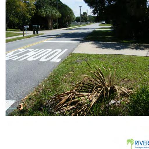
14 4 EXISTING CONDITIONS The project is located within the City of Port Orange along the south/west side of McDonald Road from the intersection of Madeline Avenue and Sugar House Drive to the intersection of 6 th Street and McDonald Road. This section of McDonald Road serves mainly residential, recreational, and public land uses. Due to the number and variety of residential land uses in the area and the proximity to Sugar Mill Elementary School, it is recommended that a designated pedestrian path be provided for the residents and students. No known road improvement projects are currently scheduled for McDonald Road. General observations of the corridor include the following: McDonald is a two-lane undivided City collector through the project limits. The corridor is a rural section with open drainage. The speed limit is 25 miles per hour (MPH) along the entire project length, including the curve. The speed limit becomes 15 MPH in the school zone when flashing. There are several residential driveways located along the corridor. There is an existing eight foot sidewalk on the north/east side of the roadway. There are existing crosswalks at the intersection of McDonald Road/Madeline Avenue at Sauls Street and McDonald Road at Charles Street. These crossing locations are controlled by crossing guards during school hours. Utilities along the corridor include: water, cable, phone, sewer, storm water, and overhead electric. Photos of the corridor are included in Appendix B. Additional details on specific locations within the corridor are detailed below. INTERSECTION WITH SAULS STREET/SUGAR HOUSE DRIVE T-Intersection at McDonald Road/Madeline Avenue at Sauls Street with approximately 150 feet to the adjacent T-intersection at Sugar House Drive. There is a sharp curve on McDonald Road east of the intersection with Sauls Street. There is a small existing section of sidewalk running from Sugar House Drive to the Sauls Street intersection, along the south side of Madeline Avenue. There are steep slopes adjacent to this section of sidewalk, leading down to an o pen drainage ditch. Existing crosswalks on the west and north sides of the intersection, with school crossing signage and markings and a school crossing guard during school hours. McDonald Road Sidewalk Feasibility Study April 2015 Kimley-Horn and Associates, Inc. 14


15 Sidewalk ramps do not have detectable warning surfaces, and there is a drainage inlet within existing sidewalk/crosswalk on northwest corner of intersection. There is existing sidewalk running along the north side of Madeline Avenue and the east side of Sauls Street. Existing pole with guy wires that may require relocation to install the proposed sidewalk. INTERSECTION WITH CHRISTY DRIVE No existing crosswalk at Christy Drive. No major obstructions located within proposed path of the sidewalk that would require relocation. Existing sidewalk along the north side of McDonald Road. Relatively flat grades on south side of McDonald Road without major drainage structures. Pedestrians observed crossing at this intersection. INTERSECTION WITH CHARLES STREET T-Intersection at McDonald Road and Charles Street. Charles Street provides access to Sugar Mill Elementary School parking lot and pick-up line. There are existing crosswalks on the west and north sides of the intersection, with school crossing signage and markings and a school crossing guard during school hours. Several dirt areas located on the south side of McDonald Road near the intersection with Charles Street. Cars sometimes pull of the roadway to temporarily wait in these areas. Existing sidewalk ramps do not have detectable warning surfaces and the existing crosswalks are skewed across both legs of the intersection. No major obstructions located within proposed path of the sidewalk that would require relocation. Some signs may need to be replaced or relocated. Stormwater drainage consists of natural percolation within the apparent right of way, no existing structures McDonald Road Sidewalk Feasibility Study April 2015 Kimley-Horn and Associates, Inc. 15
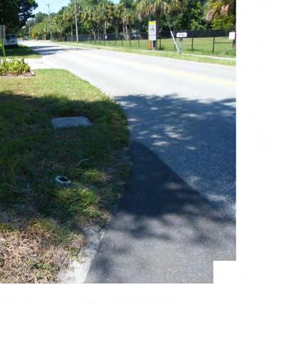
16 EXISTING DRAINAGE CROSSING UNDER MCDONALD ROAD Existing metal guardrail and sidewalk crossing on north/east side of McDonald Road. No guardrail on south/west side of McDonald Road. Drainage system crossing underneath McDonald Road appears to be used for conveyance. Headwall may need to be replaced. There is no railing along south/west side of McDonald Road, but there is a steep drop at the drainage crossing location. East of the drainage crossing, there are visible swales and drainage structures from the drainage crossing to the intersection with 6 th Street, with approximate slopes of 1:7. Existing swales would need to be re-graded to accommodate a sidewalk through these limits. Several mailboxes and private property features such as landscaping and sprinklers located within the vicinity of the proposed sidewalk. Potential right of way constraint located west of drainage crossing. INTERSECTION WITH 6TH STREET Existing four foot wide concrete sidewalk along the south side of McDonald Road, running along the edge of the Ashley Circle residences. Sidewalk appears to be outside of the existing right of way. No existing crosswalk striping or detectable warning surfaces at the intersection with 6 th Street or the intersection with Ashley Circle. No major utility obstructions within the proposed path of the sidewalk along the south/west side of the roadway. Existing swales along south/west side of roadway would need to be re-graded to accommodate sidewalk. Cracked sidewalk on north and south corners of intersection with 6 th Street. Shallow drainage pipes under sidewalk. Existing ramp on north side of intersection would need to be revised. Replacement of drainage pipe and structure may be required to accommodate new pedestrian ramp. McDonald Road Sidewalk Feasibility Study April 2015 Kimley-Horn and Associates, Inc. 16
17 5 CONCEPTUAL DESIGN RECOMMENDATIONS In accordance with the opportunities and constraints described above and applicable industry design standards, a conceptual alignment was developed for McDonald Road. Details of the recommended conceptual alignment are detailed below and further illustrated in the Conceptual Design Plans included in Appendix C. CORRIDOR RECOMMENDATIONS Generally, sidewalks may be field relocated to rout around existing utility structures as shown in the corridor design plans. Potential encroachment of private property landscape and mailboxes was noted during the site reconnaissance of the corridor. A corridor specific survey for the study area should be completed prior to the development of a sidewalk design and engineering drawings in order to identify the placement and limits of these obstructions. The following lists the general conceptual design recommendations for the corridor: Construct longitudinal grade of the sidewalk to be at grade or less than five percent in accordance with ADA Guidelines. Install pedestrian signage and a special emphasis crosswalk at Christy Drive to prevent uncontrolled crossing of students/parents during school hours. Reconstruct crosswalks and curb ramps at intersection with Charles Street to add emphasis to the area, and reduce skew of crossing locations. Utilize additional signs and markings whenever possible to provide the pedestrian and motorist clear direction. Provide ADA compliant sidewalk ramps and detectable warnings at all new and modified crosswalk locations. Route sidewalk around existing utilities within the proposed path of the sidewalk. Construct the sidewalk in accordance with the City of Port Orange Standard Construction requirements utilizing fiberglass rebar. Install flashing pedestrian signage to signal traffic approaching mid-block crosswalk at Christy Drive and T-intersection crosswalks. Recommended to maximize awareness of the crosswalk location and when a pedestrian is attempting to cross. PUBLIC INVOLVEMENT As noted in the existing conditions, there are several locations along the corridor where mailboxes, sprinklers, and landscaping may be located within the proposed path of the sidewalk. Therefore it is recommended that the property owners be made aware of the proposed improvements prior to construction of the improvements. McDonald Road Sidewalk Feasibility Study April 2015 Kimley-Horn and Associates, Inc. 17

18 RIGHT OF WAY COORDINATION Right-of-way width and encroachments dictate the most feasible and cost effective location of a sidewalk. Based on the recommended conceptual alignment, adequate clear zone and apparent right of way exists along the corridor for a five foot concrete sidewalk to be located along the south/west side of McDonald Road with one possible exception: In the vicinity of the drainage crossing, one property appears to be located approximately five feet from the existing edge of pavement. It is recommended that this property owner be contacted to discuss the potential for easements and/or right of way acquisition that would provide for a full five foot wide sidewalk to be installed at this location. In the event that right of way acquisition is not possible, a four foot wide sidewalk could still be installed at this location. While not preferred, this option would still allow for a continuous sidewalk path along the south/west side of McDonald Road. The property has a Parcel ID of Available data from the Volusia County property appraiser was used to calculate a planning level estimate for potential right of way acquisition for this property. This estimate is listed in the planning level opinion of probable cost included in Section 6. PERMITTING The proposed recommendations along the corridor result in minor modifications to existing drainage ditches and structures. Typically this work falls under St. Johns Water Management District exemption criteria. As such, an exemption verification letter could be obtained during design development. This process usually takes approximately 30 days and is anticipated to be accommodated within design schedule for the project. LOCATION SPECIFIC RECOMMENDATIONS FDOT s concerns focused primarily on two sections: the intersection of Madeline Avenue and Sugar House Drive, and the location of the drainage conveyance system in the middle of the corridor. A third area of concern, the intersection of McDonald Road and 6 th Street, was identified during the field observations. Full comments and responses are included in Appendix D. Details of the improvements recommended at these three locations are described below. INTERSECTION WITH SAULS STREET/SUGAR HOUSE DRIVE The following is recommended to provide appropriate, constructible, and cost effective solutions at this location: The existing sidewalk located along the south side of Madeline Avenue from Sugar House Drive is proposed to be reconstructed as a six foot wide sidewalk. A pedestrian railing is proposed to be added to provide additional safety next to the open drainage ditch. McDonald Road Sidewalk Feasibility Study April 2015 Kimley-Horn and Associates, Inc. 18
19 The crosswalks are proposed to be reconstructed to eliminate skew and increase visibility with special emphasis markings. No sidewalk is proposed on the east side of the intersection for the following reasons: o Potential wetland and/or major drainage impacts at the east side of the T- intersection. o No sidewalk located along the south side of Madeline Avenue west of the T- intersection. o No direct driveway access onto Madeline Avenue/McDonald Road in the vicinity of this intersection. Relocation of the existing pole and guy wires to provide additional clearance for proposed pedestrian features. EXISTING DRAINAGE CROSSING UNDER MCDONALD ROAD The following is recommended to provide appropriate, constructible, and cost effective solutions at this location: The existing headwall is proposed to be reconstructed. A pedestrian railing is proposed along the drainage crossing to increase safety, similar to the existing features on the north side of McDonald Road. East of this location, sidewalks are proposed to be added two feet from the existing edge of pavement. This will provide some clearance from vehicular traffic, while minimizing impacts to the existing drainage ditches. The ditches will be re-graded to provide adequate cross-slope along the proposed sidewalk. INTERSECTION WITH 6TH STREET The following is recommended to provide appropriate, constructible, and cost effective solutions at this location: A new crosswalk is proposed at this location to connect the existing sidewalk on the north side of McDonald Road with the proposed sidewalk on the south side of McDonald Road. The existing pipe is proposed to be removed and replaced with a longer piece of pipe. This will provide additional space in the northwest corner of the intersection to enhance the pedestrian crossing features and provide for ADA requirements. Existing drainage swales are proposed to be re-graded to accommodate the proposed sidewalk. McDonald Road Sidewalk Feasibility Study April 2015 Kimley-Horn and Associates, Inc. 19
20 6 FINANCIAL FEASIBILITY Table 1 provides a planning level Opinion of Probable Cost to construct the proposed corridor based on the conceptual alignment. The item numbers and units of measure are based on the FDOT 2015 Basis of Estimates Manual. Inflation factors provided by FDOT were used to adjust the total project cost on an annual basis from 2016 to Explanations of the key items included in the cost estimate are included below. Additional detail is included in Table 1. Mobilization Consists of work and operations necessary to begin work on a project. Includes moving in equipment and personnel, establishing temporary offices, safety equipment and sanitary facilities. May include surveying, bond and insurance expenses. Maintenance of Traffic Includes all items required to safely maintain traffic throughout a transportation work zone with minimal inconvenience to the public and fit into one of the following categories:1) cannot reasonably be quantified; 2) cannot be addressed under current pay items; 3) are incidental to the operation necessary to safely maintain traffic throughout a work zone. Clearing and Grubbing This Item is included to account for the clearing that is necessary to build the sidewalk. Pedestrian/Bicycle Railing Tubular Railing This item is included to account for the construction of a pedestrian railing to guard against hazardous field conditions. Sidewalk Concrete These items are included to account for the cost of placing sidewalk along the proposed route. The sidewalk ramps are also included in this cost as well as the Fiberglass Rebar in accordance with the City of Port Orange Standard Construction Sidewalk requirements. Detectable Warning Surface This item is included as an ADA compliant feature included within all sidewalk ramps. This item accounts for retrofitting existing sidewalk ramps with detectable warning surfaces. Performance Turf, Sod This item is included to sod all areas disturbed by construction of the proposed sidewalk. LED Crosswalk System This item is included to account for the signs with LED border enhancement and in-pavement lighting. The cost includes the conduit, conductors, advance warning signs and any other items required for complete installation. Single Post Sign, F&I, Relocate, Remove These items are included for the pedestrian crosswalk signage, as well as the installation, relocation and removal of various additional signs throughout the project. Thermoplastic, Std, White, Solid, 12 and 24 These items are included to mark the special emphasis crosswalks, as detailed in the FDOT Design Standards, Index McDonald Road Sidewalk Feasibility Study April 2015 Kimley-Horn and Associates, Inc. 20
21 Table 1 Engineer s Estimate Opinion of Probable Costs Pay Item Number Description Estimated Quantity Unit of Measure 2015 Unit Price Total Cost Mobilization 1 LS 10% $ 21, Maintenance of Traffic 1 LS 15% $ 31, Sediment Barrier 2315 LF $ 2.00 $ 4, Clearing and Grubbing AC $ 10, $ 14, Mailbox, F&I (Relocate) 9 EA $ $ 1, Lateral Ditch Excavation 90 CY $ 5.00 $ Optional Base, Base Group 9 13 SY $ $ Superpave Asphalt Concrete, Traffic C 2 TN $ $ Concrete Class NS, Gravity Wall 30 CY $ $ 14, Concrete Class I, Endwalls 5 CY $ 1, $ 6, Manhole Cover, Replace 2 EA $ $ 1, Inlets, DT BOT, Type C, <10' 1 EA $ 2, $ 2, Pipe Culvert, 18" RCP 50 LF $ $ 7, Pipe Culvert, 30'' CMP 10 LF $ $ 1, Pipe Culvert, Optional Material 36" 10 LF $ $ 1, Mitered End Section, Optional Round, 18'' SD 1 EA $ 1, $ 1, Mitered End Section, Optional Round, 30'' SD 1 EA $ 3, $ 3, Pedestrian/Bicycle Railing, Aluminum Only, 42'' Type LF $ $ 9, Concrete Sidewalk, 4" Thick (w/ Fiberglass Rebar) 1133 SY $ $ 43, Concrete Sidewalk, 6" Thick (w/ Fiberglass Rebar) 179 SY $ $ 9, Detectable Warnings 326 SF $ $ 9, Performance Turf, Sod 2699 SY $ 3.00 $ 8, Pull & Splice Box, Relocate 8 EA $ $ 3, In Roadway Light Assembly, F&I, Complete Assembly 1 AS $ 30, $ 30, Pedestrian Hybrid Beacon Assembly, F&I, Complete Assembly 3 AS $ 7, $ 21, Single Post Sign, F&I Ground Mount, Less than 12 SF 8 AS $ $ 2, Single Post Sign, Relocate 5 AS $ $ Single Post Sign, Remove 4 AS $ $ Thermoplastic, Std, White, Solid, 12" 818 LF $ 3.00 $ 2, Thermoplastic, Std, White, Solid, 24" 1174 LF $ 4.00 $ 4, Thermoplastic, Remove 504 SF $ 3.00 $ 1, Light Pole, Complete, Relocate 1 EA $ 2, $ 2, CONSTRUCTION COSTS SUBTOTAL $ 265, Design (Including Bid Package) 1 LS 30% $ 79, Right-of-Way Acquisition 1 LS -- $ 10, CEI 1 LS 12% $ 31, DESIGN / CEI SUBTOTAL TOTAL PROJECT COST $ $ 121, , FDOT Inflation-Adjusted Estimate 2016 Estimated Project Cost 2017 Estimated Project Cost 2018 Estimated Project Cost 2019 Estimated Project Cost Inflation Factor Adj. Cost $ 397, $ 407, $ 417, $ 427, NOTES: 1) THIS OPC IS BASED ON CONCEPTUAL DESIGN. 2) THIS OPC IS BASED ON HISTORICAL COST INFORMATION MADE AVAILABLE BY THE FDOT. UNIT PRICES ARE PREDOMINANTLY DERIVED FROM THE CURRENT 12-MONTH MOVING AREA AVERAGE FOR AREA 06, BUT STATEWIDE AVERAGE UNIT PRICES MAY BE UTILIZED IN SOME INSTANCES. UNIT PRICES OF SOME QUANITIES MAY HAVE BEEN INFLATED TO ACCOUNT FOR THE SMALL NATURE OF THE PROJECT. ACTUAL CONSTRUCTION COSTS WILL VARY. 3) THIS OPC DOES NOT INCLUDE THE COSTS ASSOCIATED WITH OBTAINING PERMITS. 4) THE ESTIMATE FOR DESIGN FEE INCLUDES 20% FOR ENGINEERING DESIGN & PERMITTING AND 10% FOR SURVEY. THE LIMITS OF SURVEY ARE ANTICIPATED TO BE FROM THE BACK OF CURB TO THE RIGHT OF WAY LINE FOR THE LENGTH OF 5) THE ENGINEER HAS NO CONTROL OVER THE COST OF LABOR, MATERIALS, EQUIPMENT, OR OVER THE CONTRACTOR'S METHODS OF DETERMINING PRICES OR OVER COMPETITIVE BIDDING OR MARKET CONDITIONS. OPINIONS OF PROBABLE COSTS PROVIDED HEREIN ARE BASED ON THE INFORMATION KNOWN TO ENGINEER AT THIS TIME AND REPRESENT ONLY THE ENGINEER'S JUDGMENT AS A DESIGN PROFESSIONAL FAMILIAR WITH THE CONSTRUCTION INDUSTRY. THE ENGINEER CANNOT AND DOES NOT GUARANTEE THAT PROPOSALS, BIDS, OR ACTUAL CONSTRUCTION COSTS WILL NOT VARY FROM ITS OPINIONS OF PROBABLE COSTS. McDonald Road Sidewalk Feasibility Study April 2015 Kimley-Horn and Associates, Inc. 21
22 7 CONCLUSION AND SUMMARY OF RECOMMENDATIONS The purpose of this project was to conduct a limited corridor study to assess the feasibility of providing sidewalk along the south side of McDonald Road from the intersection of Madeline Avenue at Sugar House Drive to 6 th Street. The conceptual alignment for the proposed sidewalk is included in Appendix C. Constructing sidewalk along the specified limits appears to be feasible. The key issues on the project corridor are noted below. Appropriate time should be allotted within the project schedule to address these issues either before or during design as appropriate. PUBLIC INVOLVEMENT The project corridor is located in mainly residential areas. Although it is anticipated that all improvements (with one exception) will be accommodated within the existing right of way, it is noted that the modifications may require re-grading of existing drainage areas, addition of new concrete aprons, re-grading of existing driveways, relocation of mailboxes, and other modifications that may impact the existing property owners. A coordination effort should be conducted to reach out to the property owners along McDonald Road regarding the planned improvements prior to making any changes. It is anticipated that reception to the sidewalk will be positive. From field observations and discussions, many people are concerned about the lack of sidewalk along the south/west side of McDonald Road. RIGHT OF WAY A right of way map was provided by the City of Port Orange. Based on the conceptual alignment identified, there is one area of a potential right of way constraint on the corridor. It is recommended that the ultimate schedule of the project allow time to pursue right of way acquisition with this property owner. In the event that right of way negotiations are not successful, other options may be pursued such as the installation of a four foot sidewalk along the property limits. It is noted that right of way lines are apparent. The corridor specific survey may identify additional right of way at this location. FDOT s right of way forms are included in Appendix E. DRAINAGE PERMITTING The proposed recommendations along the corridor result in minor modifications to existing drainage ditches and structures. Typically this work falls under St. Johns Water Management District exemption criteria. As such, an exemption verification letter could be obtained during design development. This process usually takes less than 30 days and is anticipated to be accommodated within design schedule for the project. McDonald Road Sidewalk Feasibility Study April 2015 Kimley-Horn and Associates, Inc. 22
23 8 DATA COLLECTION REFERENCES Data collection consisted of referencing readily available information including: The Volusia County MPO Bicycle/Pedestrian Plan, January 25, 2005 Volusia County, River to Sea TPO, The City of Port Orange, Florida Department of Transportation (FDOT), Florida Pedestrian Planning and Design Handbook, FDOT, 1999 Manual of Uniform Minimum Standards for Design, Construction and Maintenance for Streets and Highways, May 2011, (Florida Greenbook ) American Association of State Highway and Transportation Officials (AASHTO) Guide for the Planning, Design, and Operation of Pedestrian Facilities, 2004 FDOT Plans Preparation Manual (PPM), January 2015 FDOT 2015 Basis of Estimates Handbook ADA Standards for Accessible Design, Code of Federal Regulations, 28 CFR Part 36, Manual on Uniform Traffic Control Devices (MUTCD), 2009 FDOT Roadway and Traffic Design Standards, 2015 City of Port Orange Comprehensive Plan Policy Document , October 2010 Bicycle and Pedestrian Safety Review Study, Sugar Mill Elementary School, Port Orange, Florida, March 2007 McDonald Road Sidewalk Feasibility Study April 2015 Kimley-Horn and Associates, Inc. 23
24 APPENDIX APPENDIX A Sugar Mill Elementary School Safe Routes to School Study Excerpts


25 Sugar Mill Elementary School Assessment Report Volusia County MPO Bicycle and Pedestrian Safety Review Study Implementation Report Sugar Mill Elementary school Port Orange, Florida March 2007 Hoke Design, Inc. Sugar Mill Elementary School March 2007 Hoke Design, Inc. 1
26 Sugar Mill Elementary School Assessment Report Volusia County MPO Section 3: Findings and Recommendations Findings and Recommendations Sugar Mill Elementary School Fact Sheet Number of Students: 840 Number of Walkers/Bicycle Riders (observed from site visit): The day of the site visit was overcast with some sprinkles, possibly reducing the number of walkers and bicycle riders. There appeared to be fewer than 60 students walking or riding their bicycles. Number of Bicycle and Pedestrian Crash Events ( ): 4 located within walk zone, 12 outside of walk zone but within 2 miles. Year School Opened: 1982 Number of School Buses: 8 Number of Students for School Site Aftercare: pending Number of Aftercare Buses/Vans: one Votran bus 5 vans for the YMCA private aftercare Number of Students for Breakfast: 150 (estimated) Number of Bicycles: 24 Number of Bicycle Helmets: 11 Backpack Policy: No policy, students are allowed rolling backpacks Teachers Assisting in Arrival and Dismissal Safety: 1 teacher assists with car loading and unloading in the morning; 4 assist in the afternoon. Existing Safety Education: The City of Port Orange provides free helmets for students who need them. The City has recently started giving tickets instead of warnings to children bicycling without helmets. Summary of Principal Comments: The lack of sidewalks near the school is the primary concern. Summary of Crossing Guard Supervisor Comments: The intersection of Nova Road and Madeline Avenue is too large and busy for students to cross even with crossing guards. Crossing Guard Locations: Herbert Street and Old Sugar Mill Road Madeline Avenue and Sauls Street McDonald Road and Charles Street Port Orange community traffic officer staff directs traffic and crosses children at car line entrance/exit. Sugar Mill Elementary School March 2007 Hoke Design, Inc. 16
27 Sugar Mill Elementary School Assessment Report Volusia County MPO Note: Issues and recommendations in this report are based on data collected in the second half of Walk zone and school-site conditions can change rapidly, and should be verified before any recommendations are implemented. Several factors limit the number of students walking or riding bicycles to Sugar Mill Elementary School. These include: An incomplete sidewalk system - direct routes from high density residential areas to the Elementary school do not have sidewalks or sufficient right-of way for the construction of sidewalks. Specifically, Nixon Lane has very limited right of way and Old Sugar Mill Road has limited right of way and sight distance problems due to the location of the Old Sugar Mill. The railroad track located east of the school does not have a complete sidewalk system nor a pedestrian arm. Because of this hazardous condition, the school system currently provides courtesy transportation for Sugar Mill students living east of the railroad. US Highway 1, located east of the railroad tracks, creates an additional barrier for students wishing to walk or bicycle to school. Nova Road, to the west of the school, is a six-lane divided road. Crossing this roadway would require two light cycle changes and the students would need to wait in the median between cycles. The school system currently provides courtesy transportation for students living west of Nova Road. These factors all contribute to the high percentage of students whose parents drop them off at the school, causing congestion on-site during arrival and dismissal times. The planned Madeline Avenue extension will provide additional access to the school, allowing modification of the current on-campus circulation. The school Principal is reviewing the possibility of creating a one-way entrance from the proposed section of Madeline Avenue that will align with the northern border of the school site. This entrance road would exit onto Charles Street, reducing the amount of traffic near the intersection of Charles Street and McDonald Road. Because the Madeline Avenue extension is not currently funded, these measures will not provide immediate relief. At least eight new condominium units (Madeline Commons PUD) are planned for east of the school along the 5 th Street, potentially adding to the number of students living east of the school currently receiving courtesy transportation. These residents will also attend the Silver Sands Middle School on Herbert Street, west of Nova Road. The City should consider enhancing the sidewalk system between the waterfront and the elementary and middle school. Although the attendance zone does not officially include the residential development to the north of the school, many students have obtained variances to attend Sugar Mill Elementary School. Many of the students this living this close to the school may choose to walk or ride their bicycles to and from school. When the school is reviewed for attendance re-zoning, the School Board may wish to consider adding the students east of Sauls Street and along Spinnaker Circle to encourage more walkers and bicycle riders. There is a proposed multi-use trail on the FPL corridor that will provide additional Sugar Mill Elementary School March, 2007 Hoke Design, Inc. 17


28 Sugar Mill Elementary School Assessment Report Volusia County MPO bicycle and pedestrian connectivity in this area, especially for the nearby Silver Sands Middle School. Findings and Recommendations School-Site Issue: A new bridge that spans a ditch in the staff parking lot was not installed to provide handicapped accessibility. The older concrete bridge does provide flush access from the parking area to the bus drop off travel lane but does not connect to a ramp along the school sidewalk. Recommendation: At least one bridge and ramp route should be completely flush to grade to allow for a direct path of travel for persons with disabilities, strollers and wheeled carts. A new bridge in the parking area was not installed flush to grade Off-Campus Walk Zone Issue: Most of the students within the walk zone are living to the west of the school and are using roadways with one sidewalk or no sidewalks. Recommendation: Since the majority of students who walk or ride bicycles live west of the school site, there should be sidewalks along the west side of McDonald Road. This would encourage students to cross the roadway where a crossing guard is located at McDonald Road and Charles Street. Many children and parents with children crossed McDonald Road near Christy Drive to directly access the gate and sidewalk to the bicycle rack area and school. This is not a marked crossing and there is no crossing guard. Multiple students cross McDonald Road at an unmarked crossing Sugar Mill Elementary School March, 2007 Hoke Design, Inc. 18


29 Sugar Mill Elementary School Assessment Report Volusia County MPO This student uses the existing sidewalk on McDonald Road and crosses McDonald Road to access Christy Drive. Sidewalks on both sides of McDonald would have allowed this student to cross with the crossing guard at McDonald Road and Charles Street, then ride on the sidewalk to Christy Drive without riding against traffic and violating bicycle safety procedures. A student crosses McDonald away from the crossing guard location Issue: The bus driveway exit at McDonald Road has an area in front of the gate that provides unofficial temporary parking. Buses may have the height to see beyond the vehicle to notice children on the sidewalk approaching from the south, but other vehicles crossing this entrance may not be able to see approaching students. This is also the entrance to the staff parking area, adding to vehicular traffic. Recommendation: Do not allow parking in the area in front of this gate. Use cones or enforcement to deter motorists from using this space for parking. The vehicle parked near the bus/staff exit may block motorist s visibility of sidewalk users Issue: The crosswalk at the intersection of McDonald Road and Charles Street is painted to avoid the stop bar on Charles Street. This layout places the student in the roadway for a longer distance. Recommendation: Obtain an engineering review of this intersection for a more direct route to be applied during the next scheduled re-painting of the crosswalk. The crosswalk across Charles Street angles toward McDonald Road Sugar Mill Elementary School March, 2007 Hoke Design, Inc. 19


30 Sugar Mill Elementary School Assessment Report Volusia County MPO Issue: There is no crosswalk at the car drop off entrance to the school along Charles Street. The amount of traffic at the school entrance requires a traffic control person in the morning and the afternoon. He directs traffic and crosses students and their parents. The sidewalk to the school is located west of the entrance. Recommendation: Paint a crosswalk across the entrance to increase pedestrian and bicycle user safety at this crossing. The sidewalk should also be painted with yellow stop bars to provide students with direction on where to stand while waiting to be crossed. A crosswalk is needed at the school entrance off of Charles Street School crossing signs and pedestrian warning signs to MUTCD standards should also be implemented. Issue: School District staff was considering the addition of crossing guards at the intersection of Madeline Avenue and Nova Road to eliminate courtesy busing. Crossing Nova Road would require students to wait in the median for a second signal cycle to reach the opposite side of the roadway. There are no sidewalks along the south side of Madeline Avenue and students would need to cross Madeline Avenue to reach sidewalk on the north side of the road. Students living to the west of Nova Road are currently provided courtesy bus transportation due to the hazardous crossing conditions. Crosswalk users crossing Nova Road at Madeline Avenue must wait in the median for a second signal cycle Recommendation: Continue to provide courtesy transportation. Many of the students living to the west of Nova Road may not have any transportation options other than walking or bicycling to and from school. Any roadway that is wide enough and busy enough to merit two different walk cycles to cross the road should not be considered as an option for student crossings. Sugar Mill Elementary School March, 2007 Hoke Design, Inc. 20
31 APPENDIX APPENDIX B Existing Corridor Photos


32 SUGAR HOUSE DRIVE SAULSSTREET N MADELINEAVENUE MCDONALD ROAD MATCHLINE A-A EXISTING CORRIDOR PHOTOS AREA 1: INTERSECTION OF MADELINE AVENUE AND SUGAR HOUSE DRIVE 3660 Maguire Boulevard, Suite 200 Orlando, Florida Bicycle/Pedestrian Feasibility Study McDonald Road Sidewalk City of Port Orange, Florida SCALE: NTS PROJECT NO FEBRUARY 2015 heather.roberts 2/8/2015 1:26:46 PM K:\ORL_TPTO\ _McDonaldRevisions\ \PLAYRD01.dgn


33 4 1 2 N MATCHLINE A-A 3 MCDONALD ROAD MATCHLINE B-B 1 CHRISTY DRIVE EXISTING CORRIDOR PHOTOS AREA 2: INTERSECTION OF MCDONALD ROAD AND CHRISTY DRIVE 3660 Maguire Boulevard, Suite 200 Orlando, Florida Bicycle/Pedestrian Feasibility Study McDonald Road Sidewalk City of Port Orange, Florida SCALE: NTS PROJECT NO FEBRUARY 2015 heather.roberts 2/8/2015 1:29:38 PM K:\ORL_TPTO\ _McDonaldRevisions\ \PLAYRD02.dgn


34 SUGARMILL ELEMENTARY SCHOOL CHARLESSTREET N MATCHLINE B-B NIXON LANE MCDONALDROAD OLD SUGAR MILL ROAD AMBER CIRCLE MATCHLINE C-C AREA 3: INTERSECTION OF MCDONALD ROAD AND CHARLES STREET 3660 Maguire Boulevard, Suite 200 Orlando, Florida EXISTING CORRIDOR PHOTOS Bicycle/Pedestrian Feasibility Study McDonald Road Sidewalk City of Port Orange, Florida SCALE: NTS PROJECT NO FEBRUARY 2015 heather.roberts 2/8/2015 1:27:55 PM K:\ORL_TPTO\ _McDonaldRevisions\ \PLAYRD03.dgn


35 N 13 MATCHLINE C-C MCDONALDROAD ASHLEY CIRCLE 6TH STREET AREA 4: INTERSECTION OF MCDONALD ROAD AND 6TH STREET 3660 Maguire Boulevard, Suite 200 Orlando, Florida EXISTING CORRIDOR PHOTOS Bicycle/Pedestrian Feasibility Study McDonald Road Sidewalk City of Port Orange, Florida SCALE: NTS PROJECT NO FEBRUARY 2015 heather.roberts 2/8/2015 1:29:14 PM K:\ORL_TPTO\ _McDonaldRevisions\ \PLAYRD04.dgn
36 APPENDIX APPENDIX C Conceptual Design Plans


37 SAULSSTREET N MCDONALD ROAD MADELINEAVENUE MAP 2 SUGAR MILL ELEMENTARY SCHOOL SUGARHOUSEDRIVE CHRISTY DRIVE CHARLES STREET NIXON LANE AMBER CIRCLE MAP 3 MAP 4 MAP 5 OLDSUGAR MILLROAD MCDONALDROAD ASHLEY CIRCLE 6TH STREET 5TH STREET HERBERT STREET MAP 1 - PLAN LAYOUT SHEET 3660 Maguire Boulevard, Suite 200 Orlando, Florida PROJECT CORRIDOR DESIGN PLANS Bicycle/Pedestrian Feasibility Study McDonald Road Sidewalk City of Port Orange, Florida SCALE: NTS PROJECT NO FEBRUARY 2015 PAGE 1 heather.roberts 2/8/2015 1:15:58 PM K:\ORL_TPTO\ _McDonaldRevisions\ \PLAYRD00.dgn

 * * * * * * * * 0 10 N 50 EXISTING")
 PROPOSED 2' DETECTABLE WARNING SURFACE EXTEND PIPE AND ADD MITERED END")
 SAULSSTREET TIE TO EXIST. SIDEWALK CONCRETE TO BE REMOVED (TYP.")

 PROPOSED")
 PROPOSED DETECTABLE WARNING SURFACE (TYP.) (INDEX NO.")

 * * * * * * * * EXIST. HEADWALL TO REMAIN EXIST.")
 PROPOSED 6' SIDEWALK WITH 42\" PEDESTRIAN RAILING OM1-1 (4) R6-4 (2)")
 COUNTYOFVOLUSIA PROPOSED CONCRETE GRAVITY WALL AND PEDESTRIAN RAILING")


38 BIKE ROUTE BEGIN STOP END SUGAR HOUSE DRIVE LEGEND EXIST. POWERPOLE EXIST. FIRE HYDRANT EXIST. SIGN EXIST. PULL BOX EXISTING PARCEL BOUNDARY EXISTING R/W EXISTING SIDEWALK S1-1 W16-7P (PROPOSED SIGN WITH LED BORDER ENHANCEMENT) * * * * * * * * 0 10 N 50 EXISTING VALLEY GUTTER EXISTING EDGE OF PAVEMENT PROPOSED SIGN PROPOSED 5' SIDEWALK (4" CONCRETE) PROPOSED 2' DETECTABLE WARNING SURFACE EXTEND PIPE AND ADD MITERED END SECTION. REGRADE SURROUNDING DITCH AREA. S1-1 W16-7P (EXIST. TO BE REMOVED) SAULSSTREET TIE TO EXIST. SIDEWALK CONCRETE TO BE REMOVED (TYP.) EXIST. INLET AND PAVEMENT TO REMAIN PROPOSED SPECIAL EMPHASIS CROSSWALK (INDEX NO ) Feet CONCRETE TO BE REMOVED EXIST. INLET TO REMAIN PAVEMENT TO REMAIN PROPOSED 6' SIDEWALK (4" CONCRETE) PROPOSED SPECIAL EMPHASIS CROSSWALK WITH IN PAVEMENT LED CROSSWALK SYSTEM (INDEX NO ) PROPOSED DETECTABLE WARNING SURFACE (TYP.) (INDEX NO. 310) PROPOSED 8' SIDEWALK (4" CONCRETE) MADELINEAVENUE SEE INSET A FOR INFORMATION EXIST. R/W EXIST. POLE AND GUY WIRES TO BE RELOCATED D11-1 (EXIST. TO BE RELOCATED) S1-1 W16-7P (PROPOSED SIGN WITH LED BORDER ENHANCEMENT) S1-1 W16-7P (EXIST. TO BE REMOVED) * * * * * * * * EXIST. HEADWALL TO REMAIN EXIST. R/W MCDONALDROAD AHEAD S1-1 W16-9P (EXIST. TO BE REMOVED) PROPOSED 6' SIDEWALK WITH 42" PEDESTRIAN RAILING OM1-1 (4) R6-4 (2) (EXIST. TO REMAIN) COUNTYOFVOLUSIA PROPOSED CONCRETE GRAVITY WALL AND PEDESTRIAN RAILING ALONG BACK OF PROPOSED SIDEWALK (INDEX NO. 852, 6011) EXIST. FLUME EXIST. HEADWALL TO REMAIN INSET A NOTE: 1. ALL EXISTING INFORMATION SHOWN HAS BEEN OBTAINED FROM AERIAL INTERPRETATION AND AVAILABLE PUBLIC INFORMATION. THE ROADWAY CORRIDORS HAVE NOT BEEN FIELD SURVEYED. LOCATIONS ARE APPROXIMATE AND ARE NOT INTENDED TO BE USED IN PREPARING CONSTRUCTION DRAWINGS. 2. ALL SCHOOL SIGNS AND MARKINGS ARE TO CONFORM TO FDOT INDEX NO MATCHLINE A-A S1-1 MAP 2 - INTERSECTION OF MADELINE PLAN SHEET AVENUE AND SUGAR HOUSE DRIVE W16-7P (PROPOSED SIGN heather.roberts 3660 Maguire Boulevard, Suite 200 Orlando, Florida PROJECT CORRIDOR DESIGN PLANS Bicycle/Pedestrian Feasibility Study McDonald Road Sidewalk City of Port Orange, Florida SCALE: AS SHOWN PROJECT NO APRIL 2015 PAGE 2 4/28/2015 6:01:37 PM K:\ORL_TPTO\ _McDonaldRevisions\ \PLANRD01-50 scale.dgn


 PROPOSED 5' SIDEWALK (6\" CONCRETE) PROPOSED 2'")
 25 S1-1 W16-7PL (PROPOSED SIGN) FTP-38-06 (PROPOSED SIGN) S4-3P R2-1 S4-1P (2)")
 SAN SCHOOL")
 PROPOSED SPECIAL EMPHASIS CROSSWALK (INDEX NO.")


 ( TO")

 NOTE: CONSTRUCTION DRAWINGS.")


39 SPEEDING FINES DOUBLED SCHOOL SCHOOL SPEED LIMIT 15 DAYS 7:15-8:15 1:45-2:45 W EDNESDAY AFTERNO O N 12:45-1:45 SCHOOL SPEED LIMIT 15 SCHOOL DAYS 7:15-8:15 AM 1:45-2:45 PM W EDNESDAY AFTERNOON 12:45-1:45 PM LEGEND EXIST. POWERPOLE EXIST. FIRE HYDRANT EXIST. SIGN EXIST. PULL BOX N EXISTING PARCEL BOUNDARY EXISTING R/W EXISTING SIDEWALK SUGAR MILL ELEMENTARY SCHOOL 0 10 Feet 50 EXISTING VALLEY GUTTER EXISTING EDGE OF PAVEMENT PROPOSED SIGN SCHOOL BOARD OF VOLUSIA COUNTY PROPOSED 5' SIDEWALK (4" CONCRETE) PROPOSED 5' SIDEWALK (6" CONCRETE) PROPOSED 2' DETECTABLE WARNING SURFACE CONCRETE TO BE REMOVED CITYOFPORTORANGE W1-2A (EXIST. SIGN TO REMAIN) 25 S1-1 W16-7PL (PROPOSED SIGN) FTP (PROPOSED SIGN) S4-3P R2-1 S4-1P (2) EXIST. TO REMAIN * * * * * * * * AHEAD S1-1 W16-7P (PROPOSED SIGN WITH LED BORDER ENHANCEMENT) SAN SCHOOL PAVEMENT MARKINGS (EXIST. TO REMAIN) EXIST. R/W PROPOSED CROSSWALK STRIPING (INDEX NO ) PROPOSED SPECIAL EMPHASIS CROSSWALK (INDEX NO ) SAN SPEEDING FINES DOUBLED EXIST. GATE TO REMAIN MCDONALD ROAD MATCHLINE B-B AHEAD NOTE: 44. ALL EXISTING INFORMATION SHOWN HAS BEEN OBTAINED FROM RIAL INTERPRETATION AND AVAILABLE PUBLIC INFORMATION. THE MATCHLINE A-A SCHOOL SIGNS AND MARKINGS ARE TO CONFORM TO FDOT INDEX DWAY CORRIDORS HAVE NOT BEEN FIELD SURVEYED. LOCATIONS ARE TRUCTION DRAWINGS. ROXIMATE AND ARE NOT INTENDED TO BE USED IN PREPARING S1-1 FTP W16-9P (PROPOSED SIGN) (EXIST. TO REMAIN) EXIST. R/W FTP *MODIFIED FTP (PROPOSED SIGN) OM4-1 (2) (PROPOSED SIGN) MAP 3 - INTERSECTION OF MCDONALD RD. AND CHRISTY DR. CHRISTY DRIVE STOP R1-1 S1-1 (EXIST. TO W16-7PL REMAIN) (PROPOSED SIGN) heather.roberts SIDEWALK ENDS AHEAD CROSS HERE R9-11 *MODIFIED (PROPOSED SIGN) NOTE: CONSTRUCTION DRAWINGS. NO Maguire Boulevard, Suite 200 Orlando, Florida :45-1:45 PM AFTERNOON W EDNESDAY 7:15-8:15 AM 1:45-2:45 PM DAYS SCHOOL 15 S4-3P R2-1 S4-1P (2) 1. ALL EXISTING INFORMATION SHOWN HAS BEEN OBTAINED FROM AERIAL INTERPRETATION AND AVAILABLE PUBLIC INFORMATION. THE APPROXIMATE AND ARE NOT INTENDED TO BE USED IN PREPARING 2. ALL SCHOOL SIGNS AND MARKINGS ARE TO CONFORM TO FDOT INDEX LIMIT (EXIST. TO REMAIN) ROADWAY CORRIDORS HAVE NOT BEEN FIELD SURVEYED. LOCATIONS ARE SPEED PROJECT CORRIDOR DESIGN PLANS Bicycle/Pedestrian Feasibility Study McDonald Road Sidewalk City of Port Orange, Florida SCALE: AS SHOWN PROJECT NO FEBRUARY 2015 PAGE 3 2/8/2015 1:32:19 PM K:\ORL_TPTO\ _McDonaldRevisions\ \PLANRD02-50 scale.dgn SCHOOL G OR R7 (EXI REM

 PROPOSED 5' SIDEWALK (6\" CONCRETE) PROPOSED 2'")
 AHEAD S1-1 W16-9P (PROPOSED SIGN) EXIST.")
 STOP SCHOOL BOARD OF VOLUSIA COUNTY R1-1 (EXIST.")
 PROPOSED STOP BAR STRIPING (INDEX NO. 17346) NO PARKING ANY TIME R7-1 (EXIST.")
 SPEED LIMIT 15 FLASHING PROPOSED CROSSWALK STRIPING")
 Feet AMBER CIRCLE MATCHLINE C-C EXIST.")
 NIXON LANE STOP R1-1 (EXIST. TO REMAIN) PROPOSED STOP BAR STRIPING (INDEX NO.")
 DRIVE BLOCK DONOT S1-1 W16-7P R10-7 *MODIFIED (EXIST.")
 7:15-8:15 AM 1:45-2:45 PM OR STANDING NO PARKING OR R7-2M (EXIST.")
 OLD SUGAR MILL ROAD STOP R1-1 (EXIST. TO REMAIN) 5 NOTE: 1.")


40 W HEN LEGEND EXIST. POWERPOLE EXIST. FIRE HYDRANT EXIST. SIGN EXIST. PULL BOX EXIST. MAILBOX SUGAR MILL ELEMENTARY SCHOOL 0 10 N 50 MATCHLINE B-B EXISTING PARCEL BOUNDARY EXISTING R/W EXISTING SIDEWALK EXISTING VALLEY GUTTER EXISTING EDGE OF PAVEMENT PROPOSED SIGN PROPOSED 5' SIDEWALK (4" CONCRETE) PROPOSED 5' SIDEWALK (6" CONCRETE) PROPOSED 2' DETECTABLE WARNING SURFACE CONCRETE TO BE REMOVED PROPOSED 6' SIDEWALK (4" CONCRETE) PROPOSED 8' SIDEWALK (4" CONCRETE) AHEAD S1-1 W16-9P (PROPOSED SIGN) EXIST. R/W PROPOSED CROSSWALK STRIPING (INDEX NO ) TIE TO EXIST. SIDEWALK S1-1 W16-7P (EXIST. SIGN TO BE RELOCATED) STOP SCHOOL BOARD OF VOLUSIA COUNTY R1-1 (EXIST. TO BE RELOCATED) TIE TO EXIST. SIDEWALK PROPOSED SPECIAL EMPHASIS CROSSWALK (INDEX NO ) PROPOSED STOP BAR STRIPING (INDEX NO ) NO PARKING ANY TIME R7-1 (EXIST. TO BE RELOCATED) TIE TO EXIST. SIDEWALK MCDONALD ROAD EXIST. R/W SCHOOL S5-1 (EXIST TO REMAIN) SPEED LIMIT 15 FLASHING PROPOSED CROSSWALK STRIPING (INDEX NO ) PROPOSED STOP BAR STRIPING (INDEX NO ) Feet AMBER CIRCLE MATCHLINE C-C EXIST. R/W 7:15-8:15 AM 1:45-2:45 PM OR STANDING NO PARKING OR R7-2M (EXIST. TO REMAIN) NIXON LANE STOP R1-1 (EXIST. TO REMAIN) PROPOSED STOP BAR STRIPING (INDEX NO ) 7:15-8:15 AM 1:45-2:45 PM OR STANDING NO PARKING OR R7-2M (EXIST. TO REMAIN) DRIVE BLOCK DONOT S1-1 W16-7P R10-7 *MODIFIED (EXIST. TO BE RELOCATED) OM1-1 W1-7 (EXIST. TO REMAIN) 7:15-8:15 AM 1:45-2:45 PM OR STANDING NO PARKING OR R7-2M (EXIST. TO REMAIN) 7:15-8:15 AM 1:45-2:45 PM OR STANDING NO PARKING OR R7-2M (EXIST. TO REMAIN) 7:15-8:15 AM 1:45-2:45 PM OR STANDING NO PARKING OR R7-2M (EXIST. TO REMAIN) 7:15-8:15 AM 1:45-2:45 PM OR STANDING NO PARKING OR R7-2M (EXIST. TO REMAIN) SCHOOL ZONE END S5-2 (EXIST. TO BE RELOCATED) OLD SUGAR MILL ROAD STOP R1-1 (EXIST. TO REMAIN) 5 NOTE: 1. ALL EXISTING INFORMATION SHOWN HAS BEEN OBTAINED FROM AERIAL INTERPRETATION AND AVAILABLE PUBLIC INFORMATION. THE ROADWAY CORRIDORS HAVE NOT BEEN FIELD SURVEYED. LOCATIONS ARE APPROXIMATE AND ARE NOT INTENDED TO BE USED IN PREPARING CONSTRUCTION DRAWINGS. 2. ALL SCHOOL SIGNS AND MARKINGS ARE TO CONFORM TO FDOT INDEX NO MAP 4 - INTERSECTION OF MCDONALD RD AND CHARLES ST Maguire Boulevard, Suite 200 Orlando, Florida PROJECT CORRIDOR DESIGN PLANS Bicycle/Pedestrian Feasibility Study McDonald Road Sidewalk City of Port Orange, Florida SCALE: AS SHOWN PROJECT NO FEBRUARY 2015 PAGE 4 heather.roberts 2/8/2015 1:10:42 PM K:\ORL_TPTO\ _McDonaldRevisions\ \PLANRD03-50 scale.dgn


 TIE TO EXIST.")
 AHEAD SCHOOL PAVEMENT MARKINGS (EXIST.")

 STOP R1-1 (EXIST. TO BE RELOCATED) STOP R1-1 (EXIST.")
 RECONSTRUCT EXISTING HEADWALL PROPOSED 6' SIDEWALK WITH 8\"")
 (INDEX NO.")


41 LEGEND EXIST. POWERPOLE EXIST. FIRE HYDRANT EXIST. SIGN EXIST. MAILBOX 6TH STREET N CITY OF PORT ORANGE EXISTING PARCEL BOUNDARY EXISTING R/W EXISTING SIDEWALK EXISTING VALLEY GUTTER EXISTING EDGE OF PAVEMENT REMOVE, REPLACE, AND EXTEND EXISTING DRAINAGE PIPE. ADD NEW MITERED END SECTION. OPEN CUT AND PATCH ASPHALT. Feet PROPOSED SIGN PROPOSED 5' SIDEWALK (4" CONCRETE) TIE TO EXIST. SIDEWALK PROPOSED 5' SIDEWALK (6" CONCRETE) MATCHLINE C-C S1-1 W16-9P (EXIST. TO REMAIN) AHEAD SCHOOL PAVEMENT MARKINGS (EXIST. TO REMAIN) PROPOSED 2' DETECTABLE WARNING SURFACE CONCRETE TO BE REMOVED MCDONALDROAD PROPOSED CROSSWALK STRIPING (INDEX NO ) PROPOSED STOP BAR STRIPING (INDEX NO ) PROPOSED STOP BAR STRIPING (INDEX NO ) STOP R1-1 (EXIST. TO BE RELOCATED) STOP R1-1 (EXIST. TO REMAIN) PROPOSED CROSSWALK STRIPING (INDEX NO ) RECONSTRUCT EXISTING HEADWALL PROPOSED 6' SIDEWALK WITH 8" THICKENED EDGE AND APPROXIMATELY 50 LF OF 42" RAILING (SEE MAP 6 FOR DETAIL) (INDEX NO. 870) ASHLEY CIRCLE 5 CITY OF PORT ORANGE NOTE: TAINED FROM FORMATION. THE YED. LOCATIONS ARE D IN PREPARING 1. ALL EXISTING INFORMATION SHOWN HAS BEEN OBTAINED FROM AERIAL INTERPRETATION AND AVAILABLE PUBLIC INFORMATION. THE ROADWAY CORRIDORS HAVE NOT BEEN FIELD SURVEYED. LOCATIONS ARE APPROXIMATE AND ARE NOT INTENDED TO BE USED IN PREPARING CONSTRUCTION DRAWINGS. ORM TO FDOT INDEX 2. ALL SCHOOL SIGNS AND MARKINGS ARE TO CONFORM TO FDOT INDEX NO MAP 5 - INTERSECTION OF MCDONALD RD. AND 6TH ST Maguire Boulevard, Suite 200 Orlando, Florida PROJECT CORRIDOR DESIGN PLANS Bicycle/Pedestrian Feasibility Study McDonald Road Sidewalk City of Port Orange, Florida SCALE: AS SHOWN PROJECT NO APRIL 2015 PAGE 5 heather.roberts 4/28/2015 7:51:54 PM K:\ORL_TPTO\ _McDonaldRevisions\ \PLANRD04-50 scale.dgn

42
Final Sidewalk Feasibility Study
 Garfield Drive From Anastasia Drive to Elizabeth Place City of South Daytona July 23, 2009 Final Sidewalk Feasibility Study Prepared for: Prepared by: Final Sidewalk Feasibility Study Garfield Drive 2
APPENDIX A: Complete Streets Checklist DRAFT NOVEMBER 2016
 APPENDIX A: Complete Streets Checklist DRAFT NOVEMBER 2016 Complete Streets Checklist MetroPlan Orlando s Complete Streets Checklist is an internal planning tool for staff to further implementation of
Chapter 4.3 Enterprise Elementary. Volusia County MPO. March Page 7.0
 Chapter 4.3 Enterprise Elementary Enterprise, FL Volusia County MPO March 2008 Page 7.0 Volusia County MPO Bicycle and Pedestrian School Safety Review Study Introduction Enterprise Elementary School is
Chapter 3.3 Horizon Elementary School. Volusia County MPO. June 2009
 Chapter 3.3 Horizon Elementary School Port Orange, FL Volusia County MPO June 2009 Volusia County MPO School Bicycle and Pedestrian Review Study, Phase 3C School Summary Horizon Elementary School is located
Trail Feasibility. 1. Introduction FINAL. October What s inside?
 VOLUSIA COUNTY MPO CITY OF PORT ORANGE FINAL Trail Feasibility October 2006 What s inside? 1 Introduction 2 Project Purpose & Scope 3 Physical Inventory & Assessment of Right-of- Way 4 Trail Concept Plan
CHAPTER 16 PEDESTRIAN FACILITIES DESIGN AND TECHNICAL CRITERIA TABLE OF CONTENTS
 CHAPTER 16 PEDESTRIAN FACILITIES DESIGN AND TECHNICAL CRITERIA TABLE OF CONTENTS Section Title Page 16.1 General... 16-1 16.1.1 AASHTO Reference... 16-1 16.1.2 ADA Requirements... 16-1 16.2 Sidewalks...
Chapter 3.9 Timbercrest Elementary School. Volusia County MPO. November 2008
 Chapter 3.9 Timbercrest Elementary School Deltona, FL Volusia County MPO November 2008 Volusia County MPO School Bicycle and Pedestrian Review Study, Phase 3B School Summary Timbercrest Elementary School
Access requests to County streets and roadways are processed through one of the following methods:
 13.1 GENERAL APPLICATION PROCESS Access requests to County streets and roadways are processed through one of the following methods: A. Planned Developments may set general locations for access points.
Accommodating Pedestrians in the Work Zone
 Accommodating Pedestrians in the Work Zone Guidance for Section C Plan Preparers Some impacts cannot be avoided and those impacts apply to residents, businesses, motorists, and pedestrians alike. However,
Off-road Trails. Guidance
 Off-road Trails Off-road trails are shared use paths located on an independent alignment that provide two-way travel for people walking, bicycling, and other non-motorized users. Trails specifically along
Orange Center Elementary School
 Drag and drop pic and stretch/crop to the limits of the blue rectangle (delete this text box) Orange Center Elementary School Drag and drop pic and stretch/crop to the limits of the blue rectangle (delete
ADA on Construction. Guidance for Section C Plan Preparers
 ADA on Construction Guidance for Section C Plan Preparers Some impacts cannot be avoided and those impacts apply to residents, businesses, motorists, and pedestrians alike. However, good planning can minimize
Appendix T CCMP TRAIL TRAFFIC & TRANSPORTATION DESIGN STANDARD
 Appendix T CCMP 3.3.4 TRAIL TRAFFIC & TRANSPORTATION DESIGN STANDARD 3.3.4 Trail Traffic and Transportation Design Multi-use trails have certain design standards, which vary depending on the agency that
Chapter 3.5 Osteen Elementary School. Volusia County MPO. November 2008
 Chapter 3.5 Osteen Elementary School Osteen, FL Volusia County MPO November 2008 Volusia County MPO School Bicycle and Pedestrian Review Study, Phase 3B School Summary Osteen Elementary School is located
City of Roseville Section 13 Design Standards. _Bikeways January 2016 SECTION 13 BIKEWAYS
 SECTION 13 BIKEWAYS 13-1 GENERAL The City of Roseville bikeway standards are designed to insure that transportation and recreational bikeways are constructed in a manner that would provide a safe and comfortable
Windy Ridge Elementary School
 Windy Ridge Elementary School SCHOOL ROUTE PLAN For WINDY RIDGE ELEMENTARY SCHOOL LOCATION 54 ORANGE COUNTY Prepared for: ORANGE COUNTY SCHOOL ASSESSMENT PROGRAM ORANGE COUNTY PUBLIC WORKS Traffic Engineering
City of Margate, Florida. Neighborhood Traffic Management Manual
 City of Margate, Florida Neighborhood Traffic Management Manual Table of Contents Page No. I. INTRODUCTION... 1 II. TRAFFIC CALMING REQUEST AND PROCESSING PROCEDURES... 2 1. COMPLETE AND SUBMIT PROJECT
Traffic Circulation & Pedestrian Safety Study
 Lyons Township High School North Campus La Grange, Illinois Parking Lot Vaughan Building N Main Building Prepared for: Prepared by: July 23, 2015 Contents List of Figures, iii 1. Introduction...1 2. Existing
5. RUNNINGWAY GUIDELINES
 5. RUNNINGWAY GUIDELINES These guidelines should be considered collectively when making runningway decisions. A runningway is the linear component of the transit system that forms the right-of-way reserved
Driveway Design Criteria
 Design Manual Chapter 5 - Roadway Design 5L - Access Management 5L-4 Driveway Design Criteria A. General For efficient and safe operations, access drives and minor public street intersections can be improved
Town of Mooresville, North Carolina Neighborhood Traffic Calming and Control Device Policy
 Town of Mooresville, North Carolina Neighborhood Traffic Calming and Control Device Policy Adopted January 6, 2014 Town of Mooresville Development Services Department TOWN OF MOORESVILLE NEIGHBORHOOD TRAFFIC
Active Transportation Facility Glossary
 Active Transportation Facility Glossary This document defines different active transportation facilities and suggests appropriate corridor types. Click on a facility type to jump to its definition. Bike
July 5, Arthur R. Ware, Jr. Elementary School 2017 Safe Routes to School Walkabout Report
 July 5, 2017 Arthur R. Ware, Jr. Elementary School 2017 Safe Routes to School Walkabout Report 1 Walkabout Report Introduction On April 28, 2017, City, School, and SAWMPO staff met to conduct a Safe Routes
REGIONAL BICYCLE AND PEDESTRIAN DESIGN GUIDELINES
 REGIONAL BICYCLE AND PEDESTRIAN DESIGN GUIDELINES November 16, 2011 Deb Humphreys North Central Texas Council of Governments Bicycle and Pedestrian Advisory Committee Snapshot of the Guide 1. Introduction
FLORIDA DEPARTMENT OF TRANSPORTATION DISTRICT 7 DISTRICT WIDE BICYCLE/PEDESTRIAN ACCESS TO TRANSIT SAFETY ASSESSMENT AND IMPROVEMENT PLAN
 FLORIDA DEPARTMENT OF TRANSPORTATION DISTRICT 7 DISTRICT WIDE BICYCLE/PEDESTRIAN ACCESS TO TRANSIT SAFETY ASSESSMENT AND IMPROVEMENT PLAN TRANSIT SAFETY ASSESSMENT SR 55/US 19 AT 80 TH AVE N DRAFT JUNE
NJDOT Complete Streets Checklist
 Background The New Jersey Department of Transportation s Complete Streets Policy promotes a comprehensive, integrated, connected multi-modal network by providing connections to bicycling and walking trip
ROUNDABOUTS/TRAFFIC CIRCLES
 GENERAL 1. Description This standard identifies minimum requirements that shall be met for Roundabouts and Neighborhood Traffic Circles in the design and construction of elements for Arlington County Horizontal
MAG Town of Cave Creek Bike Study Task 6 Executive Summary and Regional Significance Report
 Page 1 MAG Town of Cave Creek Bike Study Task 6 Executive Summary and Regional Significance Report August 1, 2012 MAG Project #481 Page 2 Task 6 Executive Summary and Regional Significance Report Introduction
Readington Road (C.R. 637) Construction
 Construction") Public Information Meeting Thursday, August 2, 2012 Readington Road (C.R. 637) Construction from Dreahook Road to Harlan School Road Branchburg Township, Somerset County Readington Township, Hunterdon
Public Information Meeting Thursday, August 2, 2012 Readington Road (C.R. 637) Construction from Dreahook Road to Harlan School Road Branchburg Township, Somerset County Readington Township, Hunterdon
City of Wayzata Comprehensive Plan 2030 Transportation Chapter: Appendix A
 A1. Functional Classification Table A-1 illustrates the Metropolitan Council s detailed criteria established for the functional classification of roadways within the Twin Cities Metropolitan Area. Table
TABLE OF CONTENTS LIST OF PHOTOGRAPHS EXHIBIT 1 LOCATION MAP... 2 LIST OF TABLES
 TABLE OF CONTENTS I. INTRODUCTION... 1 II. PURPOSE AND OBJECTIVES... 3 III. STUDY METHODOLOGY... 4 IV. EXISTING CONDITIONS... 5 V. SHARED USE PATH CONCEPT PLAN FEASIBILITY ANALYSIS... 9 VI. FINANCIAL FEASIBILITY...
Broad Street Bicycle Boulevard Design Guidelines
 Broad Street Bicycle Boulevard Design Guidelines Building from the strategies introduced in the 2013 Bicycle Transportation Plan and community input received thus far, City Transportation Staff have identified
Hidden Oaks Elementary School
 Hidden Oaks Elementary School SCHOOL ROUTE PLAN For HIDDEN OAKS ELEMENTARY SCHOOL LOCATION 13 ORANGE COUNTY Prepared for: ORANGE COUNTY SCHOOL ASSESSMENT PROGRAM ORANGE COUNTY PUBLIC WORKS Traffic Engineering
Appendix 3 Roadway and Bike/Ped Design Standards
 Appendix 3 Roadway and Bike/Ped Design Standards OTO Transportation Plan 2040 4/20/2017 Page A3-1 Adopted Standards The adopted OTO Design Standards and Major Thoroughfare Plan are contained herein.
Shared Use Path Design
 12B-2 Design Manual Chapter 12 - Sidewalks and Bicycle Facilities 12B - Bicycle Facilities Shared Use Path Design A. Accessible Shared Use Path Design 1. General: Applicable portions from the following
Washington St. Corridor Study
 FIGURE 7.17 Bridge Alternatives - Cross Sections 86 Discarded Alternative: Short-Term Bridge Repair Short-term repairs and west bridge span replacement were considered during analysis. Short-term repairs
Access Management Regulations and Standards
 Access Management Regulations and Standards January 2014 Efficient highway operation Reasonable property access Concept of Access Management The way to manage access to land development while preserving
This Chapter sets forth the minimum design, technical criteria and specifications to be used in the preparation of all roadway plans.
 4.1 GENERAL This Chapter sets forth the minimum design, technical criteria and specifications to be used in the preparation of all roadway plans. These Roadway Standards are for new construction and modification
Geometric Design Tables
 Design Manual Chapter 5 - Roadway Design 5C - Geometric Design Criteria 5C-1 Geometric Design Tables A. General The following sections present two sets of design criteria tables - Preferred Roadway Elements
Lake Whitney Elementary School
 Lake Whitney Elementary School SCHOOL ROUTE PLAN For LAKE WHITNEY ELEMENTARY SCHOOL LOCATION 18 ORANGE COUNTY Prepared for: ORANGE COUNTY SCHOOL ASSESSMENT PROGRAM ORANGE COUNTY PUBLIC WORKS Traffic Engineering
Chapter 2: Standards for Access, Non-Motorized, and Transit
 Standards for Access, Non-Motorized, and Transit Chapter 2: Standards for Access, Non-Motorized, and Transit The Washtenaw County Access Management Plan was developed based on the analysis of existing
Crosswalk Policy Revisions & Pedestrian & Bicycle Connection Plans. Presentation to Sanibel City Council July 16, 2013
 Crosswalk Policy Revisions & Pedestrian & Bicycle Connection Plans Presentation to Sanibel City Council July 16, 2013 Outline Crosswalk Policy Revisions Minimum Standards Goals and Objectives Pedestrian
SECTION 3 STREET DESIGN
 3.01 GENERAL SECTION 3 STREET DESIGN For purposes of geometric and structural design, streets shall be classified according to the following table. The City Engineer will determine the class of all proposed
Meadow Woods Elementary School
 Drag and drop pic and stretch/crop to the limits of the blue rectangle (delete this text box) Meadow Woods Elementary School Drag and drop pic and stretch/crop to the limits of the blue rectangle (delete
Fundamentals of Traffic Control Devices
 Fundamentals of Traffic Control Devices Traffic Engineering & Operations October 8, 2014 Raj Ponnaluri, Angela Wilhelm, and Christopher Lewis Agenda Agenda Signs Pavement Markings Signals Traffic Operations
CHAPTER 1 STANDARD PRACTICES
 CHAPTER 1 STANDARD PRACTICES OBJECTIVES 1) Functions and Limitations 2) Standardization of Application 3) Materials 4) Colors 5) Widths and Patterns of Longitudinal Pavement Marking Lines 6) General Principles
St. Francis Drive through the City of Santa Fe Corridor Study
 VII. ENGINEERING AND ENVIRONMENTAL EVALUATION TRAIL CONNECTIVITY In the southern portion of the Corridor there is a lack of a sidewalk, trail or bicycle facility within the right-ofway. However, the City
Item No. 14 Town of Atherton
 Item No. 14 Town of Atherton CITY COUNCIL STAFF REPORT CONSENT AGENDA TO: THROUGH: FROM: HONORABLE MAYOR AND CITY COUNCIL GEORGE RODERICKS, CITY MANAGER MICHAEL KASHIWAGI, COMMUNITY SERVICES DIRECTOR MARTY
West Dimond Blvd Upgrade Jodhpur Street to Sand Lake Road
 West Dimond Blvd Jodhpur St to Sand Lake CSS Transportation Project Summary Municipality of Anchorage Project # 05 005 Project Manager: John Smith, P.E. (MOA PM&E) Project Administrator: Julie Makela,
MUTCD Part 6G: Type of Temporary Traffic Control Zone Activities
 MUTCD Part 6G: Type of Temporary Traffic Control Zone Activities 6G.01 Typical Applications Each temporary traffic control (TTC) zone is different. Many variables, such as location of work, highway type,
10.0 CURB EXTENSIONS GUIDELINE
 10.0 CURB EXTENSIONS GUIDELINE Road Engineering Design Guidelines Version 1.0 March 2017 City of Toronto, Transportation Services City of Toronto Page 0 Background In early 2014, Transportation Services
M-58 HIGHWAY ACCESS MANAGEMENT STUDY Mullen Road to Bel-Ray Boulevard. Prepared for CITY OF BELTON. May 2016
 M-58 HIGHWAY ACCESS MANAGEMENT STUDY Prepared for CITY OF BELTON By May 2016 Introduction Missouri State Highway 58 (M-58 Highway) is a major commercial corridor in the City of Belton. As development has
Table of Contents. Introduction. Prompt List Arterials and Streets. Prompt List Interchange. Prompt List Intersections. Prompt List Limited Access
 Table of Contents Introduction Prompt List Arterials and Streets Prompt List Interchange Prompt List Intersections Prompt List Limited Access Prompt List MOT Prompt List Pedestrian Bicyclist Prompt List
SECTION TRAFFIC REGULATIONS
 SECTION 01550 TRAFFIC REGULATIONS PART 1 - GENERAL 1.01 OBJECTIVES A. The Contractor shall provide for safe movement of vehicular, bicycle and pedestrian traffic, including persons with disabilities in
SR 44 from US 441 / SR 500 to SR 44 / Orange Ave.
 SR 44 from US 441 / SR 500 to SR 44 / Orange Ave. Financial Project ID: 409870-1-52-01 LAKE COUNTY DESIGN ALTERNATIVE STUDY FOR MULTI-USE PATH Prepared for: FLORIDA DEPARTMENT OF TRANSPORTATION District
DISTRIBUTION: Electronic Recipients List TRANSMITTAL LETTER NO. (17-01) MINNESOTA DEPARTMENT OF TRANSPORTATION. MANUAL: Road Design English Manual
 MINNESOTA DEPARTMENT OF TRANSPORTATION. MANUAL: Road Design English Manual") DISTRIBUTION: Electronic Recipients List MINNESOTA DEPARTMENT OF TRANSPORTATION DEVELOPED BY: Design Standards Unit ISSUED BY: Office of Project Management and Technical Support TRANSMITTAL LETTER NO.
DISTRIBUTION: Electronic Recipients List MINNESOTA DEPARTMENT OF TRANSPORTATION DEVELOPED BY: Design Standards Unit ISSUED BY: Office of Project Management and Technical Support TRANSMITTAL LETTER NO.
Bases, Ballasts, and Paving
 Sections Included In This Standard: 1.1 Paving and Surfacing 1.2 Protection of the Work 1.3 Repair of Pavement 1.4 Pavement Marking 1.1 PAVING AND SURFACING A. DESIGN REQUIREMENTS 1. Applicable Design
Agenda. Overview PRINCE GEORGE S PLAZA METRO AREA PEDESTRIAN PLAN
 PRINCE GEORGE S PLAZA METRO AREA PEDESTRIAN PLAN May 28, 2008 Agenda Welcome and introductions Project overview and issue identification Planning context and strengths Design challenges and initial recommendations
CITY OF KASSON TRANSPORTATION ALTERNATIVES KASSON SAFE ROUTES TO SCHOOL
 ve ha 8t G B A Mantorville Ave N 240th Ave 16th St NE 11th Ave NE K-M HIGH SCHOOL SUNRISE TRAIL TO MANTORVILLE MNTH 57 SUNSET TRAIL TO MANTORVILLE NE PARK 16TH ST NE TRAIL K-M ELEMENTARY SCHOOL K-M MIDDLE
City of Albert Lea Policy and Procedure Manual 4.10 ALBERT LEA CROSSWALK POLICY
 4.10 ALBERT LEA CROSSWALK POLICY PURPOSE: Pedestrian crosswalks are an integral part of our transportation infrastructure. To be effective and promote safety, marked crosswalks must be installed after
Anne Arundel County BICYCLE, PEDESTRIAN, TRANSIT ASSESSMENT GUIDELINES
 Anne Arundel County BICYCLE, PEDESTRIAN, TRANSIT ASSESSMENT GUIDELINES December 2018 TABLE OF CONTENTS I. Executive Summary 3 II. When Is A Bicycle Pedestrian Transit Assessment (BPTA) Required? 4 III.
Corpus Christi Metropolitan Transportation Plan Fiscal Year Introduction:
 Introduction: The Safe, Accountable, Flexible, Efficient Transportation Equity Act: A Legacy for Users (SAFETEA-LU) has continued the efforts started through the Intermodal Surface Transportation Efficiency
ATTACHMENT NO. 11. RRLRT No. 2. Railroad / Light Rail Transit Technical Committee TECHNICAL COMMITTEE: Busway Grade Crossings STATUS/DATE OF ACTION
 ATTACHMENT NO. 11 RRLRT No. 2 TECHNICAL COMMITTEE: TOPIC: Railroad / Light Rail Transit Technical Committee Busway Grade Crossings STATUS/DATE OF ACTION RRLRT TC Draft: 06/23/2011 RRLRT TC Approval: 06/27/2014
CITY OF COCOA BEACH 2025 COMPREHENSIVE PLAN. Section VIII Mobility Element Goals, Objectives, and Policies
 CITY OF COCOA BEACH 2025 COMPREHENSIVE PLAN Section VIII Mobility Element Goals, Objectives, and Policies Adopted August 6, 2015 by Ordinance No. 1591 VIII MOBILITY ELEMENT Table of Contents Page Number
Omaha s Complete Streets Policy
 Omaha s Complete Streets Policy (Adopted August 2015) VISION To create great places and enhance our quality of life, the City of Omaha will provide safe, accessible streets for all users. Complete Streets
Recommended Roadway Plan Section 2 - Land Development and Roadway Access
 Recommended Roadway Plan Section 2 - Land Development and Roadway Access SECTION 2 Land Development and Roadway Access 2.1 Land Use and Access Management The Federal Highway Administration (FHWA) defines
CURBSIDE ACTIVITY DESIGN
 5 CURBSIDE ACTIVITY DESIGN This chapter provides design guidance for separated bike lanes adjacent to curbside activities including parking, loading and bus stops. Typical configurations are presented
Roadway Classification Design Standards and Policies. Pueblo, Colorado November, 2004
 Roadway Classification Design Standards and Policies Pueblo, Colorado November, 2004 Table of Contents Page Chapter 1. General Provisions 1.1 Jurisdiction 3 1.2 Purpose and Intent 3 1.3 Modification 3
Appendix Work Zone Traffic Control
 ppendix Work Zone Traffic Control The purpose of this appendix is to present basic guidelines for work zone traffic control and to supplement the Highway Work Zone Safety Checklist. This appendix presents
A. Arlington County Master Transportation Plan Pedestrian Element B. Arlington County Horizontal Standards H-3.1 Driveway Entrances
 GENERAL 1. Description This standard identifies minimum requirements that shall be met for all accessible ramps in the design and construction of elements for Arlington County Horizontal Design Standards.
AGENDA REPORT. Issue: Discussion of potential improvements on Barnwell Road at Niblick Drive
 AGENDA REPORT To: From: By: Honorable Mayor and City Council Members Warren Hutmacher, City Manager Tom Black, Public Works Director Date: March 23, 2016 Agenda: March 28, 2016 WORK SESSION AGENDA: Barnwell
Bicycle and Pedestrian Facilities Toolbox (Excerpt from Figure 3.1)
") Appendix B Neighborhood Connections Summaries This Appendix is a supplement to the information presented in Chapter 3 Connect People. The Appendix includes a summary or profile for each of the proposed
Appendix B Neighborhood Connections Summaries This Appendix is a supplement to the information presented in Chapter 3 Connect People. The Appendix includes a summary or profile for each of the proposed
ADA Transition Plan. City of Gainesville FY19-FY28. Date: November 5, Prepared by: City Of Gainesville Department of Mobility
 ADA Transition Plan FY19-FY28 Date: November 5, 2018 Prepared by: City Of Gainesville Department of Mobility 1.0 INTRODUCTION 1.1 BACKGROUND The federal statute known as the Americans with Disabilities
Chapter 4 On-Road Bikeways
 Chapter 4: 4-1.0 Introduction On-Road Bikeways This chapter provides guidelines to help select and design safe on-road bikeways. On-road bikeways include bicycle lanes, shared lanes, shoulders, and wide
IMPLEMENTATION WORKBOOK
 Lawrence Township Bicycle and Pedestrian Planning Assistance Study IMPLEMENTATION WORKBOOK Final Action Plan - Part 2 April 2009 Prepared For: The Township of Lawrence and the New Jersey Department of
Construction Specifications Manual
 Isle of Wight County Pedestrian and Bicycle Master Plan Construction Specifications Manual Adopted August 20, 2009 Introduction The Isle of Wight County Pedestrian and Bicycle Facilities Master Plan was
TRAFFIC CALMING GUIDE FOR TORONTO CITY OF TORONTO TRANSPORTATION SERVICES DIVISION
 TRAFFIC CALMING GUIDE FOR TORONTO CITY OF TORONTO TRANSPORTATION SERVICES DIVISION CITY OF TORONTO TRANSPORTATION SERVICES DIVISION 2016 TRAFFIC CALMING GUIDE FOR TORONTO TABLE OF CONTENTS Introduction
Gordon Proctor Director Policy on Accommodating Bicycle and Pedestrian Travel on ODOT Owned or Maintained Facilities
 Approved: Policy: 20-004(P) Responsible Office: Planning Gordon Proctor Director Policy on Accommodating Bicycle and Pedestrian Travel on ODOT Owned or Maintained Facilities I. POLICY STATEMENT: This policy
MUTCD Part 6: Temporary Traffic Control
 MUTCD Part 6: Temporary Traffic Control OMUTCD English units are preferred. OHIO MANUAL OF UNIFORM TRAFFIC CONTROL DEVICES TABLE OF CONTENTS PREFACE INTRODUCTION TABLE OF CONTENTS PART 1. GENERAL Chapter
ADA & Public Rights of Way
 ADA & Public Rights of Way Overview of Current and Up-coming Requirements FDOT Design Training Expo 2012 Orlando, FL Dean Perkins, RA - ADA Coordinator Florida Department of Transportation Office of Design,
Site Improvements
 Sections Included In This Standard: 1.1 Bicycle Facilities 1.2 Guardrails 1.3 Parking Bumpers 1.4 Traffic Signage 1.5 Traffic Signals 1.6 Traffic Impact Studies 1.7 Vision Triangle 1.8 Bus Stop Shelters
Caltrans Sloat Boulevard Pedestrian Safety Project Response to Community Questions, Comments & Concerns
 Caltrans Sloat Boulevard Pedestrian Safety Project Response to Community Questions, Comments & Concerns Revised: May 10, 2016 The California Department of Transportation (Caltrans) is planning various
CHAPTER 8 STAKING SIGNALS AND LIGHTING FIELD GUIDE. 8.1 Staking Traffic Control Signal Systems
 CHAPTER 8 STAKING STAKING Correct staking of traffic control signal or lighting systems is critical to the appropriate placement of system components. 8.1 Traffic Control Signal Systems Locating the components
WYDOT DESIGN GUIDES. Guide for. Non-NHS State Highways
 WYDOT DESIGN GUIDES Guide for Non-NHS State Highways 2014 GUIDE FOR Non-NATIONAL HIGHWAY SYSTEM (Non-NHS) STATE HIGHWAYS PRESERVATION REHABILITATION RECONSTRUCTION INTRODUCTION This Guide is directed to
Chapter 5: Crossing the Street
 Chapter 5: Crossing the Street Whether walking or bicycling, a student s journey to school will more than likely require crossing one or more streets. Per the Safe Routes to School Guide, maintained by
General Design Factors
 Chapter 3: 3-1.0 Introduction General Design Factors Mn/DOT s goals include encouraging and accommodating safe bicycling. From a design perspective, these goals are achieved by first having an understanding
SR/CR A1A PEDESTRIAN SAFETY & MOBILITY STUDY
 SR/CR AA PEDESTRIAN SAFETY & MOBILITY STUDY PEDESTRIAN / BICYCLE SAFETY REVIEW Focus Area H / 9th Street S to 3th Street N Prepared for: River to Sea Transportation Planning Organization 2570 West International
WYDOT DESIGN GUIDES. Guide for. NHS Arterial (Non-Interstate)
") WYDOT DESIGN GUIDES Guide for NHS Arterial (Non-Interstate) 2014 GUIDE FOR NATIONAL HIGHWAY SYSTEM (NHS) HIGHWAYS (NHS ARTERIALS, Non-Interstate) PRESERVATION REHABILITATION RECONSTRUCTION INTRODUCTION
WYDOT DESIGN GUIDES Guide for NHS Arterial (Non-Interstate) 2014 GUIDE FOR NATIONAL HIGHWAY SYSTEM (NHS) HIGHWAYS (NHS ARTERIALS, Non-Interstate) PRESERVATION REHABILITATION RECONSTRUCTION INTRODUCTION
INDEX. Geometric Design Guide for Canadian Roads INDEX
 Acceleration lane, see Lanes, Acceleration Access, 8.1 Access Management and Functional Classification 8.2 Access Management by Design Classification 8.3 Access Configuration 8.4 Building Set-Back Guidelines
Railroad-Highway Grade Crossing Analysis for Corridor Planning Projects
 Railroad-Highway Grade Crossing Analysis for Corridor Planning Projects Word Count: 4,305 Submission Date: August 1, 2015 Author: Adriana Rodriguez, E.I Assistant Engineer Parsons Brinckerhoff 1420 South
APPENDIX G: INTERSECTION NEEDS AT OKEECHOBEE BOULEVARD
 APPENDIX G: INTERSECTION NEEDS AT OKEECHOBEE BOULEVARD INTERSECTION NEEDS AT SR 7 and OKEECHOBEE BOULEVARD SR 7 Extension Project Development and Environment (PD&E) Study From Okeechobee Boulevard (SR
CROSSING GUARD PLACEMENT CONSIDERATIONS AND GAP ASSESSMENT
 CROSSING GUARD PLACEMENT CONSIDERATIONS AND GAP ASSESSMENT Many factors contribute to the need for a Crossing Guard. General federal guidance, provided by the FHWA MUTCD, states that adult crossing guards
Non-Motorized Transportation 7-1
 Non-Motorized Transportation 7-1 Transportation facilities no longer mean just accommodating a vehicle powered by a combustion engine. Pedestrian and non-motorized facilities are important modes of travel
Roadway Design Manual
 Roadway Design Manual Manual Notice Archive by Texas Department of Transportation (512) 302-2453 all rights reserved Manual Notice 2009-1 From: Manual: Mark A. Marek, P.E Roadway Design Manual Effective
Poor pavement condition Substandard Intersections. / Substandard bike/pedestrian/transit accommodations. Driveway access Environmental concerns
 Public Informational Meeting University Avenue (Allen Boulevard Segoe Road) March 23, 2011 City of Madison City of Middleton Village of Shorewood Hills Dane County Existing Roadway Conditions Poor pavement
Appendix C. TRAFFIC CALMING PROGRAM TOOLBOX
 Appendix C. TRAFFIC CALMING PROGRAM TOOLBOX PHASE I...2 Do Not Enter Sign...3 One-Way Sign...4 Turn Prohibition...5 Pavement Markings...6 Speed Monitoring Trailer...7 Neighborhood Speed Watch...8 Police
Public Information Meeting. Orange Camp Road. Dr. Martin Luther King Jr. Beltway to I-4. Presented by: Volusia County August 2, 2018
 Public Information Meeting Orange Camp Road Dr. Martin Luther King Jr. Beltway to I-4 Presented by: Volusia County August 2, 2018 1 Project Goals To improve the operations and safety for Orange Camp Road
Pennsylvania Avenue (CR 484) Design Alternatives Study
 Design Alternatives Study") MEMORANDUM Pennsylvania Avenue (CR 484) Design Alternatives Study Prepared for: APRIL 2016 Prepared By TABLE OF CONTENTS Project Background... 2 Previous Concept... 2 Existing Conditions... 4 New Alternatives...
MEMORANDUM Pennsylvania Avenue (CR 484) Design Alternatives Study Prepared for: APRIL 2016 Prepared By TABLE OF CONTENTS Project Background... 2 Previous Concept... 2 Existing Conditions... 4 New Alternatives...
CHAPTER 6H. TYPICAL APPLICATIONS
 2006 Edition Page 6H-1 CHAPTER 6H. TYPICAL APPLICATIONS Section 6H.01 Typical Applications Support: Whenever the acronym TTC is used in this Chapter, it refers to temporary traffic control. Standard: The
Reams Road RCA Study. Board of County Commissioners Public Hearing
 Reams Road RCA Study Board of County Commissioners Public Hearing April 24, 2018 Presentation Overview Study Overview Existing Conditions Development of Alternatives Preferred Alternative Public Involvement