Potomac River Water Quality: Current Status & Trends
|
|
|
- Amy Eaton
- 6 years ago
- Views:
Transcription
1 Potomac River Water Quality: Current Status & Trends Tom Parham Maryland Department of Natural Resources November 13 th, 2014
2 Presentation Overview 2014 Chesapeake Bay Dissolved Oxygen Conditions Historic Potomac Algal levels 2014 Potomac River Microcystis blooms
3 2014 Chesapeake Bay Dissolved Oxygen Forecast Dead Zones Areas with very low oxygen levels (less than 2mg/l) that are unsuitable for fish, crabs, oysters and other Bay organisms to survive. NOAA, USGS and University of Maryland predicted larger than average dead zone due to higher than average spring flows and Nitrogen loading
4 Chesapeake Bay Dead Zone Trends Spring/early summer dead zones were largely due to increased stratification: warmer, fresher water floating in top of cooler, saltier water. This has led to earlier, more pronounced dead zone formation caused by regional climatic factors. Analysis indicates a reduction in the late summer dead zones related to nutrient reductions that have been documented entering Chesapeake Bay at the river monitoring sites.
5 2014 Chesapeake Bay Dissolved Oxygen Conditions
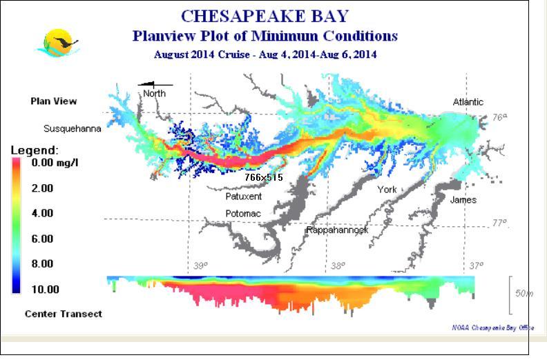
6
7 2014 Chesapeake Bay Dead zone Results Chesapeake Bay Dead zone was about average in Areas of low dissolved oxygen (<2mg/l) volume ranged from 1.32 to 0.33 cubic miles. In July, Hurricane Arthur mixed and oxygenated Bay waters greatly reducing low dissolved oxygen areas during July
8 Volume x 10E06 (cubic meters) Lower Potomac River hypoxic volume 3000 Total summer volume below 2 mg/l for the lower Potomac River Year
9 Chesapeake Bay Dissolved Oxygen and Chlorophyll a Trends
10 chlorophyll a (ug/l) Historic Potomac River algal levels Phytoplankton biomass middle Potomac TF2.1 S TF2.3 S TF2.4 S
11 Tidal Water Quality Monitoring (MD) Long-term on-going monthly monitoring since 1985
12 Fail Meet Algal Density
13 Nitrogen N Load Blue Plains Loads data: N levels in tidal waters
14 Nitrogen data
15 Phosphorus P Load Blue Plains Loads data: P levels in tidal waters
16 data Phosphorus
17 Cells/milliter Potomac River Bluegreen Algae conditions 70,000 60,000 Microcystis Blue-greens 50,000 40,000 30,000 20,000 10,000 0 Year Figure 2. Historical time series ( ) for summer mean concentration of Blue-greens (filaments, colony counts plus cells/ml of Microcystis and variable Microcystis (cells/ml.) Indianhead Station. (Summer= July, August and September)


18 Liverpool Point Microcystis bloom Occurred during September 2014 Located south of Mallows Bay High Microcystis aeruginosa cell count (50 million) Charles County Health Dept issued a water advisory Bay Journal
19 Summary Dissolved Oxygen Chesapeake Bay Dead Zone average size in 2014 Lower Potomac River bottom dissolved oxygen conditions mirror nearby Bay mainstem Nutrients Improving nutrient trends in non-tidal portion of Potomac River Improving nitrogen/phosphorus conditions in upper and middle tidal areas improving throughout the river Algae Increasing chlorophyll a concentrations in Piscataway area since 2010 Large Microcystis bloom near Mallows Bay in September
20 For More Information
21 END
22 Summary: Nutrient and Sediments Nitrogen improving throughout the river levels still too high in most areas, but have dropped ~30% since 1999 Phosphorus improving in the upper and middle river levels still too high in the middle river, but have dropped ~30% since 1999 Total Suspended Sediments getting worse in the middle river, between 20-50% higher since 1999 levels borderline or too high in many areas
23 Summary Summer Bottom Dissolved Oxygen Lower river levels are dangerously low all summer Low dissolved oxygen generally in bottom waters but surface waters can also have low DO Light availability for underwater grasses Poor in upper and middle river, some locations are getting worse Poor in shallow waters Algal densities (Chlorophyll a levels) Meet underwater grass habitat levels in most of middle and lower mainstem of river but not in shallower waters But middle river is getting worse
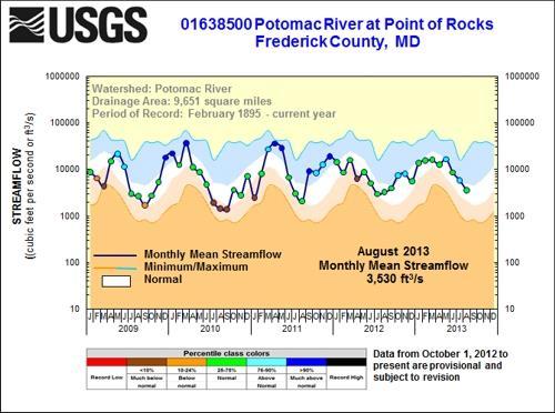
24 Scale of bloom (% samples with blooms)- green bars Average bloom cell density (cells ml *1000) Historic Potomac River algal levels
25 Historic Potomac River algal levels Little Falls discharge spring flow summer flow 140, , ,000 80,000 60,000 40,000 20, ,000 70,000 60,000 50,000 40,000 30,000 20,000 10,000 0
26 TN (mg/l) Major Declines in Nitrogen TN middle Potomac 5 TF2.1 S TF2.3 S TF2.4 S
27 TP (mg/l) Slight decline in Phosphorus Phosphorus middle Potomac TF2.1 S TF2.3 S TF2.4 S
28 TN:TP Upper Potomac System is P limited Nutrients above Redfield Ratio TF2.1 S TF2.3 S TF2.4 S :1
29 DIN (mg/l) DIN declines, still above SAV threshold DIN middle Potomac 5 TF2.1 S TF2.3 S TF2.4 S
30 DIP (mg/l) Phosphate declines DIP middle Potomac TF2.1 S TF2.3 S TF2.4 S
31 Annual Streamflow Point of Rocks (cfs) 0 2,000 4,000 6,000 8,000 10,000 12,000 14,000 16,000 18,000 20,
32
Managing Chesapeake Bay s Land Use, Fish Habitat, and Fisheries: Studies. Jim Uphoff & Margaret McGinty, Fisheries Service
 Managing Chesapeake Bay s Land Use, Fish Habitat, and Fisheries: Positive Image and or Negative Graphic Case Studies Jim Uphoff & Margaret McGinty, Fisheries Service Maryland Fisheries Service has been
Monitoring Cruise Report
 r/v Gunnar Thorson Monitoring Cruise Report Cruise no.: 214 Time: 1-19 February 23 Area: The Sound, the Kattegat, the Skagerrak, the North Sea, the Belt Sea and the Arkona Sea Ministry of the Environment
Managing Development and Chesapeake Bay s Estuarine Fish
 Managing Development and Chesapeake Bay s Estuarine Fish Habitat Image and or Graphic Fisheries James H. Uphoff Jr. and Margaret M. McGinty Maryland Fisheries Service Funded through USFWS Federal Aid Maryland
Water Quality Analysis of Total Phosphorus for the Lower Gunpowder Falls Watershed, Baltimore County, Maryland
 Water Quality Analysis of Total Phosphorus for the Lower Gunpowder Falls Watershed, Baltimore County, Maryland DEPARTMENT OF THE ENVIRONMENT 1800 Washington Boulevard, Suite 540 Baltimore MD 21230-1718
Chemistry and Water Quality
 Chemistry and Water Quality Overview of sediment and water quality conditions and implications for biological systems including highlights of current research and data gaps. Facilitator: Christopher Krembs,
How often does dissolved oxygen (DO) in the estuary fall below 5 mg/l?
 in the estuary fall below 5 mg/l?") Indicator: Dissolved oxygen in the Great Bay Estuary Question How often does dissolved oxygen (DO) in the estuary fall below 5 mg/l? Short Answer Datasondes, an automated water quality sensor or probe,
Indicator: Dissolved oxygen in the Great Bay Estuary Question How often does dissolved oxygen (DO) in the estuary fall below 5 mg/l? Short Answer Datasondes, an automated water quality sensor or probe,
(ml/l), (mg/l) or (ppm)
, (mg/l) or (ppm)") Oxygen Optode What is this sensor? This sensor is used to detect dissolved oxygen and oxygen saturation levels in a given body of water i. Oxygen sensors detect Dissolved Oxygen, often abbreviated to DO.
Oxygen Optode What is this sensor? This sensor is used to detect dissolved oxygen and oxygen saturation levels in a given body of water i. Oxygen sensors detect Dissolved Oxygen, often abbreviated to DO.
NOAA s Role in Chesapeake Bay
 NOAA s Role in Chesapeake Bay NOAA Chesapeake Bay Office Mission To understand, predict and explain changes in the Chesapeake Bay ecosystem, and to coordinate efforts to conserve and manage coastal and
Historical and current observations on macroalgae in the Hillsborough Bay Estuary
 University of South Florida Scholar Commons Reports Tampa Bay Area Study Group Project 1-1-2002 Historical and current observations on macroalgae in the Hillsborough Bay Estuary J.O.R. Johansson Bay Study
Monitoring Cruise Report
 r/v Gunnar Thorson Monitoring Cruise Report Cruise no.: 228 Time: 7-18 February 25 Area: The Sound, the Kattegat, the Skagerrak, the North Sea, the Belt Sea and the Arkona Sea Ministry of the Environment
Properties. terc.ucdavis.edu 8
 Physical Properties 8 Lake surface level Daily since 1900 The lowest lake level on record was 6,220.26 feet on Nov. 30, 1992. Since 1900, lake level has varied by more than 10 feet. Lake level typically
Recent changes in invasive zebra mussel abundance in Gull Lake. Jeffrey D. White GLQO Annual Meeting 12 August 2014
 Recent changes in invasive zebra mussel abundance in Gull Lake Jeffrey D. White GLQO Annual Meeting 12 August 2014 Zebra mussels: background Introduced: 1980s from Europe/Asia Transported: ballast water
Refined Designated Uses for the Chesapeake Bay and Tidal Tributaries
 A-1 appendixa Refined Designated Uses for the Chesapeake Bay and Tidal Tributaries BACKGROUND Federal water quality standards regulations establish that states must specify appropriate water uses to be
Indian River Lagoon: Lessons, Challenges and Opportunities
 Indian River Lagoon: Lessons, Challenges and Opportunities Upper Chain of Lakes Lake Kissimmee Kissimmee River Indian River Lagoon Caloosahatchee Estuary Lake Okeechobee St. Lucie Estuary Mark Perry, Executive
Office of Science & Technology
 NOAA Fisheries Highlights of FEUS 2015 Highlights from the Annual Report Fisheries Economics of the United States, 2015 Office of Science & Technology Fisheries and the Economy U.S. fisheries provide jobs,
Jason Blackburn, Paul Hvenegaard, Dave Jackson, Tyler Johns, Chad Judd, Scott Seward and Juanna Thompson
 Alberta Conservation Association (ACA) Date: 2014-2015 Project Name: Owl River Walleye and Aquatic Habitat Assessment Fisheries Program Manager: Peter Aku Project Leader: Tyler Johns Primary ACA staff
EVALUATING THE EFFECTS OF BIVALVE SHELLFISH AQUACULTURE AND ITS ECOLOGICAL ROLE IN THE ESTUARINE ENVIRONMENT IN THE UNITED STATES
 EVALUATING THE EFFECTS OF BIVALVE SHELLFISH AQUACULTURE AND ITS ECOLOGICAL ROLE IN THE ESTUARINE ENVIRONMENT IN THE UNITED STATES Brett Dumbauld USDA Agricultural Research Service, Hatfield Marine Science
BAY-SIC RATIOS. W. A.V.E. BAY-SIC Ratios
 BAY-SIC RATIOS INTRODUCTION: The land that surrounds the Chesapeake Bay spans 64,000 square miles and includes portions of six states Virginia, West Virginia, Maryland, Pennsylvania, Delaware, and New
Well, Well, Well. BACKGROUND Seasonal upwelling is a very important process in the coastal ocean of the Pacific Northwest.
 Well, Well, Well SUMMARY In this activity students investigate the relationship between winds, surface currents, sea surface temperature and upwelling and downwelling off the coast of OR and WA. Students
Status of Lake Erie s Western Basin Fish Populations: Trends and Environmental Conditions
 Status of Lake Erie s Western Basin Fish Populations: Trends and Environmental Conditions Jeff Tyson Ohio Department of Natural Resources Ohio Division of Wildlife Status of the Lake Erie s Western Basin
JadEco, LLC PO BOX 445 Shannon, IL 61078
 Introduction: With the assistance of Lake Holiday staff and volunteers, we were able to conduct an AC electrofishing survey on May 8, 27. Water temperatures were 2.3 C (8.5 F) and water clarity was decent
Warm-up # 7 A day 5/17 - B day 5/18 UPDATE YOUR TABLE OF CONTENTS
 Warm-up # 7 A day 5/17 - B day 5/18 UPDATE YOUR TABLE OF CONTENTS Question: List all examples of surface water on Earth. Answer: Rivers and streams, lakes and reservoirs, (ponds) wetlands, estuaries and
Environmental drivers of forage dynamics in Chesapeake Bay
 Environmental drivers of forage dynamics in Chesapeake Bay Ryan Woodland 1, Edward Houde 1, Carlos Lozano 1, Andre Buchheister 2, Robert Latour 3, Christopher Sweetman 3, Mary Fabrizio 3, Troy Tuckey 3
Aunified management approach among
 December 2003 Amendment 1 1997 Chesapeake Bay Blue Crab Fishery Management Plan INTRODUCTION Aunified management approach among the Bay jurisdictions was initiated with the development of the 1989 Chesapeake
Oxbows and Sloughs: Wisconsin s Forgotten Lakes
 University of Massachusetts - Amherst ScholarWorks@UMass Amherst International Conference on Engineering and Ecohydrology for Fish Passage International Conference on Engineering and Ecohydrology for Fish
Grade 8 Science. Unit 1: Water Systems on Earth Chapter 3
 Grade 8 Science Unit 1: Water Systems on Earth Chapter 3 Heat Capacity A measure of how long it takes a material to heat up or cool down. Water has a high heat capacity... It takes a long time to heat
NYS Coastal Waters. Water Resources of NYS: THE NATURE of the COASTAL ZONE. NYS Coastal Waters. NYS Coastal Atlas. Coastal Zone Management 10/10/2014
 Water Resources of NYS: THE NATURE of the COASTAL ZONE NYS Coastal Waters NYS is the only state to border the Atlantic Ocean and the Great Lakes (Lakes Erie and Ontario). Great Lakes shoreline: 577 miles
SALINITY. It's the amount of dissolved salts the water contains.
 AQUATIC ECOSYSTEMS SALINITY The types of organisms in an aquatic ecosystem depend upon the water s Salinity. It's the amount of dissolved salts the water contains. Salinity determines the two main aquatic
ECOSYSTEM SHIFTS IN THE BALTIC SEA
 ECOSYSTEM SHIFTS IN THE BALTIC SEA Michele Casini Swedish University of Agricultural Sciences 21/12/211 Ecosystem Shifts in the Baltic Sea 1 The area Central Baltic Sea Finland Sweden 29 Gulf of Finland
located Let s go fishing Hydrilla
 Our Lake of the Month for November is Lake August (set your GPS to 27.2750-81.4136). The elevation of Lake August is 102.5. Lake August is a 52 acre dredge hole lake (man-made from a former wetland; see
Mass coral mortality under local amplification of 2 C ocean warming
 Mass coral mortality under local amplification of C ocean warming Thomas M. DeCarlo, Anne L. Cohen, George T.F. Wong, Kristen A. Davis, Pat Lohmann, Keryea Soong correspondence to: tdecarlo@uwa.edu.au
2017 State of the Tidal Potomac River Largemouth Bass Fishery (Maryland) Joe Love
 Joe Love") 2017 State of the Tidal Potomac River Largemouth Bass Fishery (Maryland) Joe Love Joseph.love@maryland.gov 410-260-8257 1 Background Targeted Black Bass Surveys Markham et al. (2002); Love (2004) Standard
2017 State of the Tidal Potomac River Largemouth Bass Fishery (Maryland) Joe Love Joseph.love@maryland.gov 410-260-8257 1 Background Targeted Black Bass Surveys Markham et al. (2002); Love (2004) Standard
From Phosphorus to Fish: Beneficial Use of Excess Nutrients
 FLOATINGISLANDINTERNATIONAL From Phosphorus to Fish: Beneficial Use of Excess Nutrients Project Location: Shepherd, Montana Fishing can be the primary method for transitioning excess nonpoint source nutrients
2012 Maryland FMP Report (July 2013) Section 15. Red Drum (Sciaenops ocellatus)
 Section 15. Red Drum (Sciaenops ocellatus)") 1981 1983 1985 1987 1989 1991 1995 1997 1999 2001 2003 2005 2007 2009 2011 Pounds 2012 Maryland FMP Report (July 2013) Section 15. Red Drum (Sciaenops ocellatus) Chesapeake Bay FMP In 2012, red drum were
1981 1983 1985 1987 1989 1991 1995 1997 1999 2001 2003 2005 2007 2009 2011 Pounds 2012 Maryland FMP Report (July 2013) Section 15. Red Drum (Sciaenops ocellatus) Chesapeake Bay FMP In 2012, red drum were
2001 STATUS OF ATLANTIC MENHADEN STOCK AND FISHERY
 2001 STATUS OF ATLANTIC MENHADEN STOCK AND FISHERY Report of the Atlantic Menhaden Technical Committee July 1, 2001 1. Executive Summary The Atlantic Menhaden Technical Committee met in Richmond, Virginia
Author's personal copy
 DOI 10.1007/s12237-014-9867-5 Relative Importance of Nutrient Load and Wind on Regulating Interannual Summer Hypoxia in the Chesapeake Bay Ping Wang & Harry Wang & Lewis Linker Received: 5 September 2013
THE ONGOING AQUATIC MONITORING PROGRAM FOR THE GUNSTON COVE AREA OF THE TIDAL FRESHWATER POTOMAC RIVER. FINAL REPORT November 2011
 1 THE ONGOING AQUATIC MONITORING PROGRAM FOR THE GUNSTON COVE AREA OF THE TIDAL FRESHWATER POTOMAC RIVER 2 FINAL REPORT November 211 by R. Christian Jones Professor Department of Environmental Science
Lecture Benthic Ecology
 Lecture Benthic Ecology Benthos Unlike the drifting plankton and swimming nekton, benthic organisms commonly referred to as benthos live on or near the ocean bottom A benthic habitat may be shallow or
Richard Kraus Assistant Professor Department of Environmental Science and Policy George Mason University Co-Principal Investigator
 1 THE ONGOING AQUATIC MONITORING PROGRAM FOR THE GUNSTON COVE AREA OF THE TIDAL FRESHWATER POTOMAC RIVER 28 FINAL REPORT December 29 by R. Christian Jones Professor Department of Environmental Science
EcoLogic Memorandum. TO: Ben Brezell; EDR FROM: Mark Arrigo RE: Possible Impacts of Dredging Snooks Pond DATE: 6/4/07
 EcoLogic Memorandum TO: Ben Brezell; EDR FROM: Mark Arrigo RE: Possible Impacts of Dredging Snooks Pond DATE: 6/4/07 Background EDR P.C. (EDR) has been contracted by a landowner to assess the feasibility
ENSO Update Eastern Region. Michelle L Heureux Climate Prediction Center / NCEP/ NOAA 29 November 2016
 ENSO Update Eastern Region Michelle L Heureux Climate Prediction Center / NCEP/ NOAA 29 November 2016 Summary La Niña conditions are present.* ENSO Alert System Status: La Niña Advisory Equatorial sea
Today: Coastal Issues and Estuaries
 Today: Coastal Issues and Estuaries Coastal issues Human effect on coastlines What is an estuary Why are they so important? Circulation of water in estuary Environmental issues Coastal Issues: Problem
RECREATIONAL PONDS AND LAKES
 RECREATIONAL PONDS AND LAKES POND ECOLOGY AQUATIC PLANTS & FISH F.S. Conte Department of Animal Science University of California Davis Photos By Flickr AQUATIC PLANTS POND HEALTH Chemical Recycling Oxygen
Richard Kraus Assistant Professor Department of Environmental Science and Policy George Mason University Co-Principal Investigator
 1 THE ONGOING AQUATIC MONITORING PROGRAM FOR THE GUNSTON COVE AREA OF THE TIDAL FRESHWATER POTOMAC RIVER 2009 FINAL REPORT December 20 by R. Christian Jones Professor Department of Environmental Science
Introduction: JadEco, LLC PO BOX 445 Shannon, IL 61078
 Introduction: was contacted to collected data on the fishery for Lake Holiday. AC Electroshocking was conducted at 2 locations on September 28, 2015. Fish population data was collected for a total of 100
CARL BLACKWELL LAKE MANAGEMENT PLAN
 CARL BLACKWELL LAKE MANAGEMENT PLAN Background Lake Carl Blackwell impounds Stillwater Creek, 10 miles west of Stillwater in Payne County, Oklahoma (Figure 1). The lake covers 3,370 surface acres and was
El Niño Lecture Notes
 El Niño Lecture Notes There is a huge link between the atmosphere & ocean. The oceans influence the atmosphere to affect climate, but the atmosphere also influences the ocean, which can also affect climate.
Climate Change Impacts on Great Lakes Fishes
 Climate Change Impacts on Great Lakes Fishes Stuart A. Ludsin ludsin.1@osu.edu Changing Climate Webinar Series The Ohio State University 19 April 2011 Today s Presentation Great Lakes Fish Community A
Blue crab ecology and exploitation in a changing climate.
 STAC Workshop 28 March 2017 Blue crab ecology and exploitation in a changing climate. Thomas Miller Chesapeake Biological Laboratory University of Maryland Center for Environmental Science Solomons, MD
The Chesapeake Bay as an Estuary: An introduction. Istvan A. Urcuyo Gettysburg College
 The Chesapeake Bay as an Estuary: An introduction. Istvan A. Urcuyo Gettysburg College The Chesapeake Bay -Native Americans resided on its shores since 8000 B.C. The Chesapeake Bay -Original Native American
The Estimations of Nutrient Cycles of Artificial Tidal Flat in Tokyo Bay
 The Estimations of utrient Cycles of Artificial Tidal Flat in Tokyo Bay Kazuo MURAKAMI, ana SASAKI, Tomohiro KUWAE, and Hirotsugu ISHII Tokyo City University The Role of Tidal Flat for Coastal Environment
FISHERIES BLUE MOUNTAINS ADAPTATION PARTNERSHIP
 FISHERIES A warming climate, by itself, substantially affects the hydrology of watersheds in the Blue Mountains. Among the key hydrologic changes projected under all scenarios for the 2040s and beyond
Fish kill events and observed mortality reported to NCDWR during 2013
 Fish kill events and observed mortality reported to NCDWR during 203 Total 203 Fish Kills: 3 Total 203 Fish Mortality: 20,608,452 203 Fish Kill Events (by County) Beaufort 9/30/203 WA3002 Pamlico River
Ocean Inter-annual Variability: El Niño and La Niña. How does El Niño influence the oceans and climate patterns?
 Name: Date: Guiding Question: Ocean Inter-annual Variability: El Niño and La Niña How does El Niño influence the oceans and climate patterns? Introduction What is El Niño/La Niña? The El Niño/La Niña cycle
Collaborative. City of Stuart. September 7, Mark Perry, Executive Director Oceanographic Society. Upper Chain of Lakes
 Lake Okeechobee Collaborative Upper Chain of Lakes Lake Kissimmee Indian River Lagoon City of Stuart September 7, 2016 Kissimmee River Caloosahatchee Estuary Lake Okeechobee St. Lucie Estuary Everglades
How many adult oysters are in the Great Bay Estuary and how has it changed over time?
 Indicator: in the Great Bay Estuary Question How many adult oysters are in the Great Bay Estuary and how has it changed over time? Short Answer The number of adult oysters decreased from over 25 million
WFC 50 California s Wild Vertebrates Jan. 11, Inland Waters (Lakes and Streams) Lisa Thompson
 Lisa Thompson") Inland Waters: Lakes and Streams WFC 50 11 January 2011 Lisa Thompson Fisheries Extension Specialist Wildlife, Fish, & Conservation Biology Department University of California, Davis Take home messages
Inland Waters: Lakes and Streams WFC 50 11 January 2011 Lisa Thompson Fisheries Extension Specialist Wildlife, Fish, & Conservation Biology Department University of California, Davis Take home messages
Neutrally Buoyant No More
 Intended Class: Marine Science Intended Grade Level: 11-12 Neutrally Buoyant No More Time Allotment: Two, 55-minute periods. Day one should be lecture, background information and giving the students time
UNIVERSITY OF CAMBRIDGE INTERNATIONAL EXAMINATIONS General Certificate of Education Advanced Subsidiary Level and Advanced Level
 UNIVERSITY OF CAMBRIDGE INTERNATIONAL EXAMINATIONS General Certificate of Education Advanced Subsidiary Level and Advanced Level *2677524077* MARINE SCIENCE 9693/03 Structured Questions May/June 2013 Paper
Coral Reefs Lecture Notes
 Coral Reefs Lecture Notes (Topic 10D) page 1 Coral Reefs Lecture Notes Corals Polyps & Zooxanthellae Coral Polyps Are coral polyps algae or animals? Description (What do coral polyps look like? Make a
Six Mile Halsted Bay Subwatershed Carp Management Implementation Plan
 Six Mile Halsted Bay Subwatershed Carp Management Implementation Plan May 18, 2017 Table of Contents Contents Executive Summary... 3 Overview of Carp in Six Mile Halsted Bay Subwatershed... 6 Management
LAKE TANEYCOMO 2011 ANNUAL LAKE REPORT
 LAKE TANEYCOMO 211 ANNUAL LAKE REPORT Shane Bush Fisheries Management Biologist Missouri Department of Conservation Southwest Region March 1, 212 EXECUTIVE SUMMARY Lake Taneycomo was formed by the construction
1873 Delta: Long residence time. Marsh connections. Two rivers connect to bay. Waterways dendritic
 1873 Delta: Long residence time Marsh connections Two rivers connect to bay Waterways dendritic 4 Modern delta Short residence times Rip-rapped Cross Delta flows Rare San Joaquin connection to bay Waterways
Overview of herring related findings of NCEAS Portfolio Effects Working Group
 Overview of herring related findings of NCEAS Portfolio Effects Working Group Northwest Eric Ward, Rich Brenner eric.ward@noaa.gov richard.brenner@alaska.gov September 8, 2017 Acknowledgments Thanks to
Chesapeake Bay Instantaneous Minimum Dissolved Oxygen Criteria: History and Background
 Chesapeake Bay Instantaneous Minimum Dissolved Oxygen Criteria: History and Background Rich Batiuk Associate Director for Science, Analysis and Implementation Chesapeake Bay Program Office U.S. Environmental
Keuka Lake State of the Lake 2017
 Keuka Lake State of the Lake 2017 1 2 Lake Characteristics Third largest by area of the Finger Lakes 11,730 ac Deep and steep sided - max 185 ft mean 101 ft Two story fishery (warmwater/coldwater) 178,800
SECTION 2 HYDROLOGY AND FLOW REGIMES
 SECTION 2 HYDROLOGY AND FLOW REGIMES In this section historical streamflow data from permanent USGS gaging stations will be presented and discussed to document long-term flow regime trends within the Cache-Bayou
Forecasting of Lower Colorado River Basin Streamflow using Pacific Ocean Sea Surface Temperatures and ENSO
 Forecasting of Lower Colorado River Basin Streamflow using Pacific Ocean Sea Surface Temperatures and ENSO Glenn A. Tootle 1 and Thomas C. Piechota 2 1 Dept. of Civil and Environmental Engineering, University
NIANGUA SNAPSHOT ISSUE Nutrients 2 Suspended Sediment 3 Salinity 4 Summary 5
 Niangua River Watershed Snapshot Volume 14 Number 2 The 125-mile long Niangua River meanders northward from the town of Marshfield on I-44 to the Lake of the Ozarks. Its watershed covers more than 658,000
Frequency of Percnon gibbesi in relation to. Diadema antillarum at Rodney s Rock
 Frequency of Percnon gibbesi in relation to Diadema antillarum at Rodney s Rock By: Rickey Wallace Study Abroad Dominica Summer 2007 Texas A&M University Dr. Bob Wharton Dr. Jim Woolley Abstract The nimble
Subtidal and intertidal restored reefs in North Carolina
 Subtidal and intertidal restored reefs in North Carolina Jonathan H. Grabowski 1, Sean P. Powers 2, Pete Peterson 3, and Hunter S. Lenihan 4 1 Gulf of Maine Research Institute/U. Maine-Darling Marine Center
Forage Fish Outcome Management Strategy , v.1
 Management Strategy 2015 2025, v.1 I. Introduction Photo credit: Virginia Institute of Marine Science. Bay anchovy (Anchoa mitchilli). Forage species are an important component of the food web linking
RAMP Objectives. RAMP Studies
 2008 Monitoring Results Fort Chipewyan, June 9, 2009 Presented by: Fred Kuzmic Wade Gibbons Martin Davies Heather Keith Hatfield Consultants. All Rights Reserved. 8/12/2009 SLIDE 1 What is RAMP? Initiated
Peyton Robertson, Director, NOAA Chesapeake Bay Office Frank Dawson, Assistant Secretary, MD DNR Jeff Corbin, Assistant Secretary, VA Natural
 Peyton Robertson, Director, NOAA Chesapeake Bay Office Frank Dawson, Assistant Secretary, MD DNR Jeff Corbin, Assistant Secretary, VA Natural Resources Baywide Harvest 120 100 Harvest (Millions of Pounds)
Biological limits to submerging salmon
 Biological limits to submerging salmon Tim Dempster - Jon-Erik Juell - Institute of Marine Research 1 Why submerge salmon?! Surface-based cages function well most of the time however 2 Why submerge salmon?!
Quiz name: Oceanography - Land and Sea Interaction - Quiz #2
 Name: Quiz name: Oceanography - Land and Sea Interaction - Quiz #2 ate: 1. What is the direction of spin for gyres in the northern hemisphere? clockwise counter clockwise northern oscillation southern
29 National Estuarine Research Reserves
 Estuarine habitat is where it's at! Living Shorelines for Erosion Control Whitney Jenkins North Carolina Coastal Reserve & National Estuarine Research Reserve Division of Coastal Management 29 National
Becky Bolinger NIDIS IMW Drought Early Warning System Webinar November 21, 2017
 NIDIS Intermountain West Dec-Feb Winter Outlook Becky Bolinger NIDIS IMW Drought Early Warning System Webinar November 21, 2017 COLORADO CLIMATE CENTER La Niña Advisory And associated impacts from La Niña
Chesapeake Bay Fisheries 101. Edward Houde Chesapeake Bay Commission Annapolis, MD 7 January 2016
 Chesapeake Bay Fisheries 101 Edward Houde Chesapeake Bay Commission Annapolis, MD 7 January 2016 Content of This Presentation Synopsis of Status of Key Fisheries Status of Science Supporting Management
Hypolimnetic Oxygenation for Indian Creek Reservoir Restoration. Bill Faisst CA/NV AWWA Fall Conference October 22, 2014
 Hypolimnetic Oxygenation for Indian Creek Reservoir Restoration Bill Faisst CA/NV AWWA Fall Conference October 22, 14 Indian Creek Reservoir High desert lake Little runoff ~ acre foot volume Regulatory
A PROJECT OF THE ANN ARBOR CHAPTER OF MICHIGAN TROUT UNLIMITED
 ESTABLISHING A TROUT FISHERY IN MILL CREEK A PROJECT OF THE ANN ARBOR CHAPTER OF MICHIGAN TROUT UNLIMITED A REPORT PREPARED BY THE MILL CREEK FISHERY DEVELOPMENT COMMITTEE: THOMAS EDSALL 1, CARLOS FETTEROLF
Chapter 9 Insolation control of monsoons 2004/4/15
 Chapter 9 Insolation control of monsoons 2004/4/15 Introduction Monsoon circulations exist on Earth today because the land responds to seasonal changes in solar radiation much more quickly than does the
Linear and non-linear responses of marine and coastal fish populations to physics and habitat: a view from the virtual world
 Linear and non-linear responses of marine and coastal fish populations to physics and habitat: a view from the virtual world Kenneth Rose Dept. of Oceanography & Coastal Sciences Louisiana State University
NATIVE OYSTER RESTORATION AT ELKHORN SLOUGH, CALIFORNIA Summary of Elkhorn Slough National Estuarine Research Reserve and Elkhorn Slough Foundation
 NATIVE OYSTER RESTORATION AT ELKHORN SLOUGH, CALIFORNIA Summary of Elkhorn Slough National Estuarine Research Reserve and Elkhorn Slough Foundation partnership project Pain%ng by Cory and Catska Ench,
CHAPTER 7 Ocean Circulation
 1 2 3 4 5 6 7 8 9 10 11 12 13 14 CHAPTER 7 Ocean Circulation Words Ocean currents Moving seawater Surface ocean currents Transfer heat from warmer to cooler areas Similar to pattern of major wind belts
Water Quality in the River Test at Leckford
 Summary Water Quality in the River Test at Leckford Site of Special Scientific Interest A serious decline in freshwater invertebrates at Leckford is investigated. Recent Invertebrate surveys have shown
Dan O Keefe, Ph.D. Ottawa County Water Quality Forum November 19, 2018
 Dan O Keefe, Ph.D. Ottawa County Water Quality Forum November 19, 2018 Sea Grant Communication Products YouTube Channel Fish Notes enewsletter MSU Extension News Fact sheets and brochures Reports and white
Long-term Trends of Red Tides by Eutrophication and Toxic Blooms by Oligotrophication in the Seto Inland Sea of Japan
 Long-term Trends of Red Tides by Eutrophication and Toxic Blooms by Oligotrophication in the Seto Inland Sea of Japan Ichiro Imai 1, Masafumi Natsuike 1 Keigo Yamamoto 2 Tetsuya Nishikawa 3 Satoshi Nagai
Ocean and Plume Science Management Uncertainties, Questions and Potential Actions (Work Group draft 11/27/13)
") Ocean and Plume Science Management Uncertainties, Questions and Potential Actions (Work Group draft 11/27/13) (The work group thinks the following four questions should form a logic path, but that logic
Ocean and Plume Science Management Uncertainties, Questions and Potential Actions (Work Group draft 11/27/13) (The work group thinks the following four questions should form a logic path, but that logic
ATON System Workshop
 ATON System Workshop ATON System: Real-time current measurements from Coast Guard navigation buoys in ports, bays and the coastal ocean Aid-to-Navigation = ATON ATON System Workshop Outline: Overview of
2015 Maryland FMP Report (June 2016) Section 10. Maryland Coastal Bays Blue Crab (Callinectes sapidus)
 Section 10. Maryland Coastal Bays Blue Crab (Callinectes sapidus)") 2015 Maryland FMP Report (June 2016) Section 10. Maryland Coastal Bays Blue Crab (Callinectes sapidus) Maryland s Coastal Bays and Chesapeake blue crab fisheries are managed separately under two different
2015 Maryland FMP Report (June 2016) Section 10. Maryland Coastal Bays Blue Crab (Callinectes sapidus) Maryland s Coastal Bays and Chesapeake blue crab fisheries are managed separately under two different
Lecture 5.1 Surface Ocean Circulation. Image from Daily Mail Newspaper, UK
 Lecture 5.1 Surface Ocean Circulation Image from Daily Mail Newspaper, UK Announcements Midterm is Thursday, consists of 25 multiple choice, 3 pages short answer questions No Scantron needed Calculators,
Examples of estuaries include bays, sounds, salt marshes, mangrove forests, mud flats, swamps, inlets, and sloughs.
 An estuary is a partially enclosed body of water where incoming seawater is mixed with fresh water coming from the land. Examples of estuaries include bays, sounds, salt marshes, mangrove forests, mud
Geology. Key Factors. Overfishing. Great Lakes Fishes. Historical Fishing. About 10,000 years since last glacial retreat very young ecologically
 Great Lakes Fishes Geology About 10,000 years since last glacial retreat very young ecologically Largest surface freshwater system on earth 21% of world s supply 84% of North America s supply Five unique
SALINITY AND DISSOLVED OXYGEN IN THE MISSISSIPPI RIVER GULF OUTLET NAVIGATION CHANNEL AND IN ADJACENT SURFACE WATERS,
 SALINITY AND DISSOLVED OXYGEN IN THE MISSISSIPPI RIVER GULF OUTLET NAVIGATION CHANNEL AND IN ADJACENT SURFACE WATERS, 2008-2012 Southeast Louisiana Flood Protection Authority-East Coastal Advisory Committee
2012 Maryland FMP Report (July 2013) Section 8. Bluefish (Pomatomus saltatrix)
 Section 8. Bluefish (Pomatomus saltatrix)") 2012 Maryland FMP Report (July 2013) Section 8. Bluefish (Pomatomus saltatrix) Chesapeake Bay FMP Bluefish are popular with recreational anglers because they are strong fighters. Commercial fisheries are
2012 Maryland FMP Report (July 2013) Section 8. Bluefish (Pomatomus saltatrix) Chesapeake Bay FMP Bluefish are popular with recreational anglers because they are strong fighters. Commercial fisheries are
Florida Seagrass Integrated Mapping and Monitoring Program
 Florida Seagrass Integrated Mapping and Monitoring Program - 2004 The following document is composed of excerpts taken from the 2011 publication, Seagrass Integrated Mapping and Monitoring for the State
Impacts of climate change on marine fisheries
 Impacts of climate change on marine fisheries Dr Jim Salinger Principal Scientist, NIWA, Auckland j.salinger@niwa.co.nz Outline Observed changes in ocean climate Observed changes in fisheries Future ocean
For Creative Minds. Salt Marsh Plants and Animals
 For Creative Minds The For Creative Minds educational section may be photocopied or printed from our website by the owner of this book for educational, non-commercial uses. Cross-curricular teaching activities,
Monitoring Cruise Report
 r/v Gunnar Thorson Monitoring Cruise Report Cruise no.: 211 Time: 14-18 October 22 Area: The Sound, the Kattegat, the Belt Sea and the Arkona Sea Ministry of the Environment National Environmental Research