91
|
|
|
- Juliet Pierce
- 5 years ago
- Views:
Transcription
1 90
2 91
3 92
4 93
5 94
6 95
7 96
8 97
9 98
10 99
11 100
12 101
13 102
14 103
15 104
16 105
17 106

18 As previously depicted in Exhibit 4-J, vehicular accidents are shown along Forrester Road. The contributing factors may be due to its current two lane undivided configuration, unsignalized cross streets, and poor lighting conditions. Accidents along Forrester Road appear to be concentrated at the segment south of Baughman Road to Imler Road and south of Worthington Road to the Interstate 8 Freeway Ramps. The prevalence of head-on collisions along Forrester Road can be attributed to the current two lane undivided configuration and the type of vehicles travelling on the roadways. Heavy truck traffic and slow moving farm equipment frequently travel on Forrester Road. Some motorists tend to pass slow moving vehicles by switching to the on-coming travel lane to pass the slow moving vehicle, which is currently allowed along certain stretches on Forrester Road. There are several factors to consider in determining the cause of head on collisions: driver error, sight distance issues, lane configuration, speed limit and etc. From January 2005 to October 2007, four head-on collision accidents have occurred on Forrester Road which resulted in one fatality. The picture above illustrates a slow moving farm vehicle travelling on Forrester Road The accident data indicates that three fatalities have occured along Forrester Road from January 2005 to October 2007 as a result of a motor vehicle accident. Two of the fatalities occurred in To determine whether these fatal motor accidents are indicative of the average rate of a particular type of roadway, the Bureau of Transportation Statistics has determined that the national fatality rate for a collector Forrester Road Interregional Corridor Study County of Imperial, CA (JN: ) 107
19 108
20 109
21 110
22 111
23 112
24 113
25 114
26 115
27 116
28 117
29 118
30 119
31 120
32 121
33 122
34 123
35 124
36 125
37 126
38 127
39 128
40 129
41 130
42 131
43 132
44 133
45 134
46 135
47 136
48 137
49 138
50 139
51 140
52 141
53 142
54 143
55 144

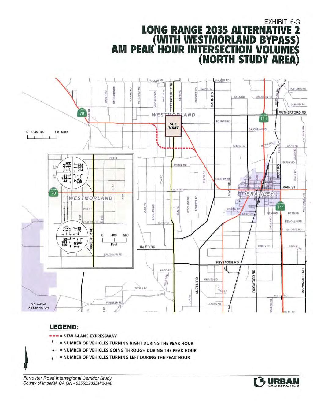
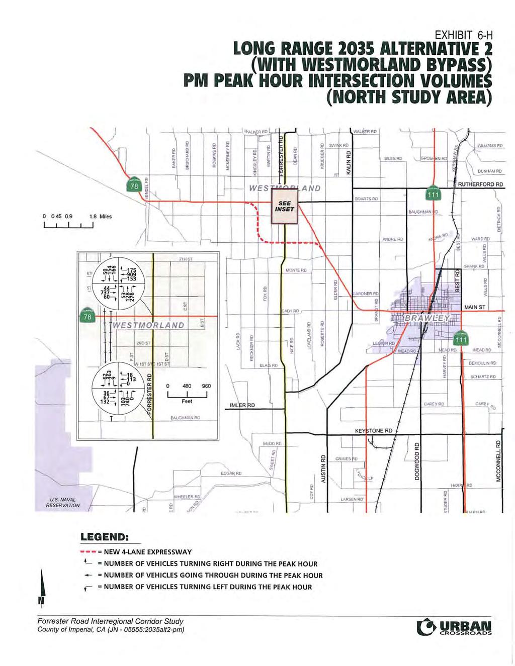
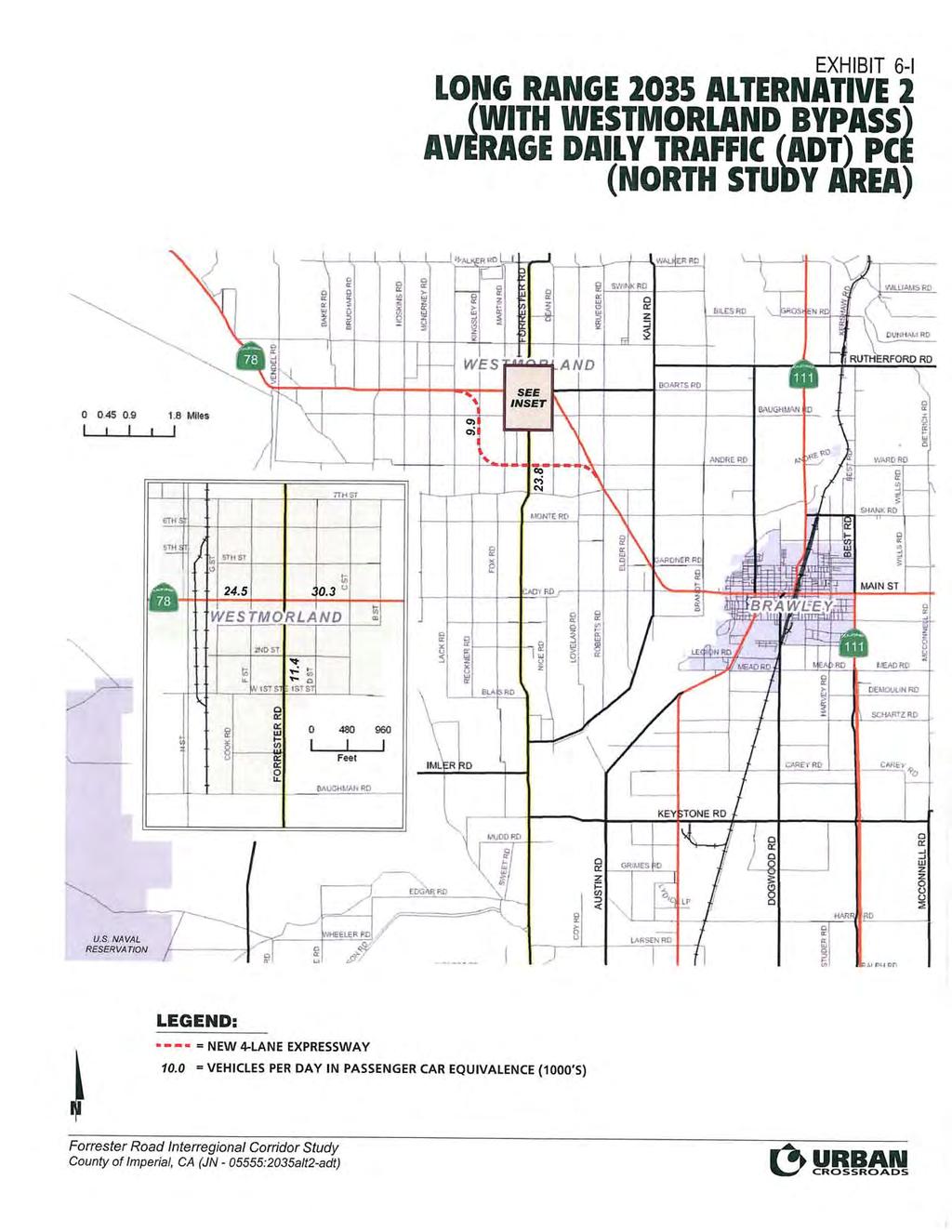
56 area locations: SR-78/86 / Forrester Road and Baughman Road/ Forrester Road. The comparison indicates that the intersection delays for Alternative 2 at the intersections of Forrester Road/ Baughman Road and Forrester Road/ SR- 78/86 are lower than Alternative 3. The Westmorland Bypass diverts traffic volumes away from the City of Westmorland and reduces overall traffic at the two aforementioned intersections. Instead of diverting traffic away from these two intersections, the Eastern Bypass re-routes the northbound traffic away from the intersection of Forrester Road/ Baughman Road to travel east towards the SR-78/86. The truck bypass alternatives are anticipated to address local concerns of traffic congestion and safety, and to minimize the degradation of pavement (compared to retaining the current configuration of this road segment). The pavement rehabilitation program outlined in the report should be undertaken to accommodate the future increase in traffic volumes. Appendix S contains the City of Westmorland s South Center Street Pavement Rehabilitation Report. The image above taken at 1 st Street/ Forrester Road illustrates the rutting of the roadway. Forrester Road Interregional Corridor Study County of Imperial, CA (JN: ) 145
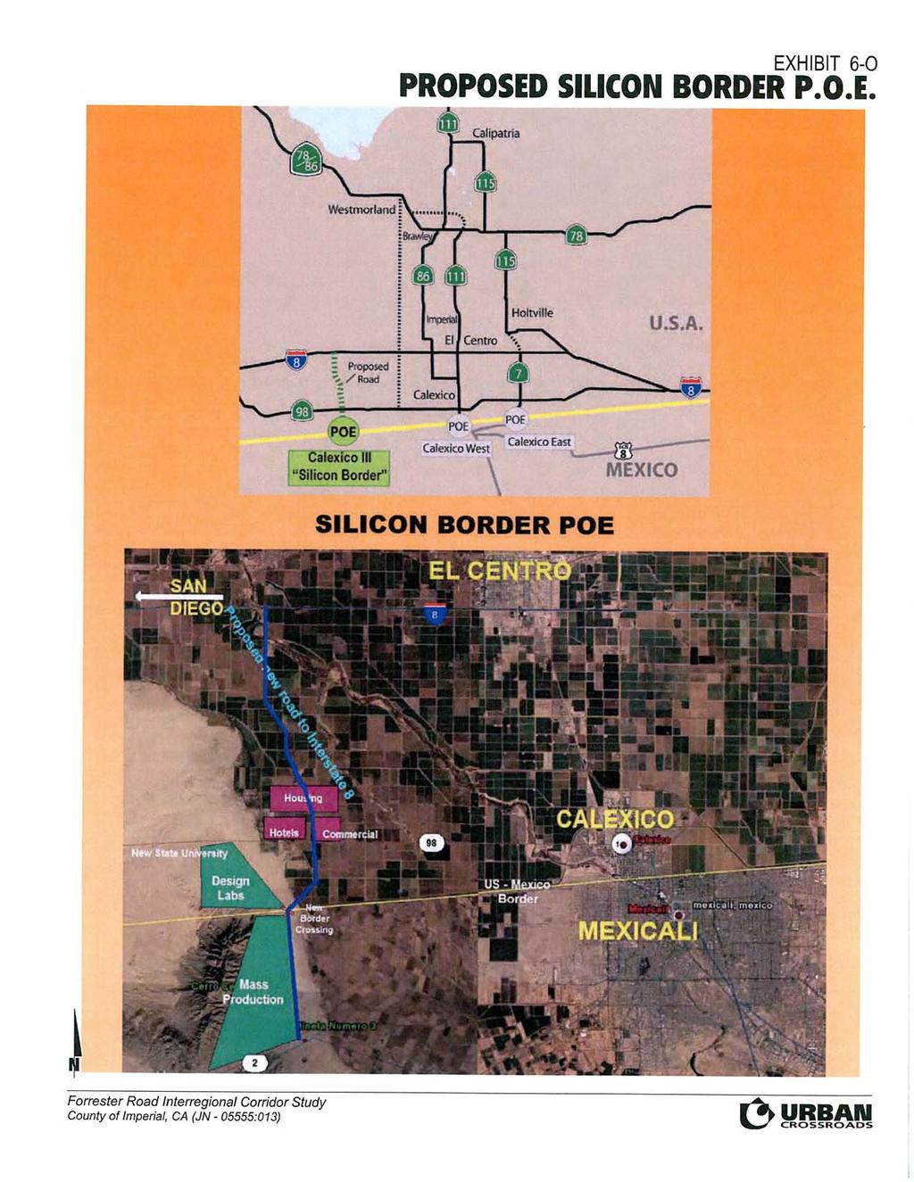
57 City of Westmorland residents are concerned with the economic visibility of some of the businesses affected by the truck diversion. Alternative 2 (Westmorland Bypass) diverts traffic away from the City of Westmorland subsequently reducing traffic volumes east and west of Forrester Road along the SR-78/86. Reduction in traffic volumes may affect local business located along the State Route within the City of Westmorland as the anticipated decrease in traffic reduces the opportunity of motorists passing-by to patronize Alternative 4: Silicon Border Port of Entry A high technology industrial complex on the U.S/ Mexico border is currently under discussion. The Silicon Industrial Complex at Baja California could create 100,000 jobs in the Mexicali/ Imperial border region over the next 20 years. A new port of entry (P.O.E) west of Forrester Road at the U.S. Mexico border has been proposed to accommodate the trade traffic generated by the high technology industrial complex. Exhibit 6-O indicates the location of the proposed P.O.E and industrial complex. The Silicon Border P.O.E will connect the industrial complex with Interstate 8. This connection will subsequently increase traffic volumes along the Interstate 8 freeway due to the termination of the proposed link at the Interstate 8 junction. This in turn will force trade traffic to travel east or west along I-8. It is anticipated that this will likely increase truck traffic along Forrester Road since it is the nearest northsouth arterial connecting to SR-78/86. Unless a new north-south arterial is constructed, it is expected that truck traffic associated with the proposed P.O.E will utilize Forrester Road as a route for northern travel, subsequently increasing traffic volumes along Forrester Road. An option has been discussed to extend the proposed terminus of the new roadway between the P.O.E and at Interstate 8 to connect to SR-78/86. The construction of a new north-south roadway, west of Forrester Road will be met with major challenges including addressing logistical, topographical, and environmental issues. A north-south arterial west of Forrester Road requires support and coordination from various local, state and federal agencies. Since the Silicon Border P.O.E and the industrial complex is still under the Forrester Road Interregional Corridor Study County of Imperial, CA (JN: ) 146
58 147
59 148
60 149
61 150
62 151
63 152
64 153
65 154
66 155
67 156
68 157
69 158
70 159
71 160
72 161
73 162
74 163
75 164
76 165
77 166
78 167
79 168
80 169
81 170
82 171
83 172
84 173
85 174
86 175
87 176
88 177
City of Prince Albert Statement of POLICY and PROCEDURE. Department: Public Works Policy No. 66. Section: Transportation Issued: July 14, 2014
 Page: 1 of 8 1 POLICY 1.01 The City shall follow all of the specifications in the Manual of Uniform Traffic Control Devices for Canada, prepared by the National Committee of Uniform Traffic Control, and
Frequently Asked Questions
 Frequently Asked Questions Business US 190 in Copperas Cove From Avenue D to Constitution Drive What is access management? A. Access Management is a growing effort by government agencies to improve how
Congestion Management Report
 Congestion Management Report F.E. EVERETT TURNPIKE (NORTH), MERRIMACK Segment Length: 7.0 miles Daily Traffic Volumes: 60,000-69,000 Analysis Period: May 2015 Number of Traffic Signals: 0 Number of travel
M-58 HIGHWAY ACCESS MANAGEMENT STUDY Mullen Road to Bel-Ray Boulevard. Prepared for CITY OF BELTON. May 2016
 M-58 HIGHWAY ACCESS MANAGEMENT STUDY Prepared for CITY OF BELTON By May 2016 Introduction Missouri State Highway 58 (M-58 Highway) is a major commercial corridor in the City of Belton. As development has
Gwinnett County Department of Transportation SR 324 / Gravel Springs Road at I-85 / SR 403 Interchange Project Number F , PI No.
 June 4, 2015 Dear Resident: Thank you for attending this public information meeting for the proposed SR 324 / Gravel Springs Road at I-85 Interchange. The purpose of this meeting is two-fold: to provide
MUTCD Part 6G: Type of Temporary Traffic Control Zone Activities
 MUTCD Part 6G: Type of Temporary Traffic Control Zone Activities 6G.01 Typical Applications Each temporary traffic control (TTC) zone is different. Many variables, such as location of work, highway type,
Welcome! San Jose Avenue Open House August 25, 2015
 Welcome! San Jose Avenue Open House August 25, 2015 Vision Zero The City and County of San Francisco adopted Vision Zero San Francisco Vision Zero High Injury Network as a policy in 2014, committing an
City of Wayzata Comprehensive Plan 2030 Transportation Chapter: Appendix A
 A1. Functional Classification Table A-1 illustrates the Metropolitan Council s detailed criteria established for the functional classification of roadways within the Twin Cities Metropolitan Area. Table
Bicycle - Motor Vehicle Collisions on Controlled Access Highways in Arizona
 Bicycle - Motor Vehicle Collisions on Controlled Access Highways in Arizona Analysis from January 1, 1991 to June 30, 2002 Richard C. Moeur, PE Traffic Design Manager, Northern Region Michelle N. Bina
Traffic Circulation Study for Neighborhood Southwest of Mockingbird Lane and Airline Road, Highland Park, Texas
 ARIZONA TEXAS NEW MEXICO OKLAHOMA February 13, 2015 Mr. Meran Dadgostar P.E., R.S. Town of Highland Park 4700 Drexel Dr. Highland Park, Texas 75205 Re: Traffic Circulation Study for Neighborhood Southwest
Appendix T CCMP TRAIL TRAFFIC & TRANSPORTATION DESIGN STANDARD
 Appendix T CCMP 3.3.4 TRAIL TRAFFIC & TRANSPORTATION DESIGN STANDARD 3.3.4 Trail Traffic and Transportation Design Multi-use trails have certain design standards, which vary depending on the agency that
MoPac South: Impact on Cesar Chavez Street and the Downtown Network
 MoPac South: Impact on Cesar Chavez Street and the Downtown Network Prepared by: The University of Texas at Austin Center for Transportation Research Prepared for: Central Texas Regional Mobility Authority
APPENDIXB. Traffic Operations Technical Memorandum
 APPENDIXB Traffic Operations Technical Memorandum Environmental Assessment - Lincoln County, SD 85 th Street: Sundowner Avenue to Louise Avenue November 2017 MEMORANDUM Transportation Jim Kollbaum, PE
Chapter 4 Traffic Analysis
 Chapter 4 Traffic Analysis PURPOSE The traffic analysis component of the K-68 Corridor Management Plan incorporates information on the existing transportation network, such as traffic volumes and intersection
Traffic Impact Analysis Walton Acres at Riverwood Athletic Club Clayton, NC
 Traffic Impact Analysis Walton Acres at Riverwood Athletic Club Clayton, NC 1. TABLE OF CONTENTS INTRODUCTION...1 1.1. Site Location and Study Area...1 1.2. Proposed Land Use and Site Access...2 1.3.
4. ENVIRONMENTAL IMPACT ANALYSIS 9. TRANSPORTATION AND TRAFFIC
 4. ENVIRONMENTAL IMPACT ANALYSIS 9. TRANSPORTATION AND TRAFFIC 4.9.1 INTRODUCTION The following section addresses the Proposed Project s impact on transportation and traffic based on the Traffic Study
DIMARCO CANANDAIGUA PROPERTIES HOUSING PROJECT CANANDAIGUA, ONTARIO COUNTY, NEW YORK
 TRAFFIC IMPACT STUDY FOR THE DIMARCO CANANDAIGUA PROPERTIES HOUSING PROJECT CANANDAIGUA, ONTARIO COUNTY, NEW YORK MARCH 14, 2017 PREPARED FOR: 1950 Brighton Henrietta Town Line Rd Rochester, NY 14623 PREPARED
3.0 PROJECT DESCRIPTION
 The following section of the Draft EIR contains a description of the proposed Elk Grove Boulevard/SR 99 Interchange Modification project, consistent with the requirements of CEQA Guidelines Section 15124.
CHAPTER 7 ACCESS MANAGEMENT. Background. Principles of Access Management. Hennepin County Transportation Systems Plan (HC-TSP)
") CHAPTER 7 ACCESS MANAGEMENT Background Principles of Access Management Hennepin County Transportation Systems Plan (HC-TSP) Chapter 7 Access Management 7.1 Background Access management has become an important
CHAPTER 7 ACCESS MANAGEMENT Background Principles of Access Management Hennepin County Transportation Systems Plan (HC-TSP) Chapter 7 Access Management 7.1 Background Access management has become an important
Glenn Avenue Corridor Traffic Operational Evaluation
 Glenn Avenue Corridor Traffic Operational Evaluation PREPARED FOR: THE CITY OF AUBURN PREPARED BY: DECEMBER 2007 Glenn Avenue Corridor Study--Auburn, Alabama TABLE OF CONTENTS Introduction... 1 Background
Military Road Safety Improvements
 Military Road Safety Improvements 26 th Road North to 31 st Street North SUMMARY OF DATA REVIEW AND PRELIMINARY RECOMMENDATIONS Prepared for: Department of Environmental Services Traffic Engineering and
DEPARTMENT OF ENVIRONMENTAL SERVICES. North Harrison Street (Lee Highway to Little Falls Road) Comparative Analysis. Prepared for:
 Comparative Analysis. Prepared for:") DEPARTMENT OF ENVIRONMENTAL SERVICES North Harrison Street (Lee Highway to Little Falls Road) Comparative Analysis Prepared for: Arlington County Department of Environmental Services 2100 Clarendon Boulevard,
DEPARTMENT OF ENVIRONMENTAL SERVICES North Harrison Street (Lee Highway to Little Falls Road) Comparative Analysis Prepared for: Arlington County Department of Environmental Services 2100 Clarendon Boulevard,
JONESBORO HIGHWAY 63 HIGHWAY 18 CONNECTOR STUDY
 JONESBORO HIGHWAY 63 HIGHWAY 18 CONNECTOR STUDY Craighead County May 2007 JONESBORO HIGHWAY 63 HIGHWAY 18 CONNECTOR STUDY Craighead County May 2007 Prepared by Planning and Research Division Arkansas State
Student Pedestrian Safety Fiddlers Canyon Elementary Community Council 2012
 Student Pedestrian Safety Fiddlers Canyon Elementary Community Council 2012 Introduction Fiddlers Canyon Elementary students must cross North Wedgewood Lane and Fiddlers Canyon Drive in order to come to
CITY OF OTTAWA ROADWAY MODIFICATION APPROVAL UNDER DELEGATED AUTHORITY
 RMA-2015-ATM-038 CITY OF OTTAWA ROADWAY MODIFICATION APPROVAL UNDER DELEGATED AUTHORITY DATE: April 22, 2015 SUBJECT Approval of Roadway Modifications Recommended through an Area Traffic Management Study
Lincoln Avenue Road Diet Trial
 Lincoln Avenue Road Diet Trial Data Collection Report June 1, 2015 Department of Transportation Table of Contents I. Introduction...... 3 II. Data Collection Methodology & Results...... 5 A. Traffic Volume
TRAFFIC IMPACT STUDY And A TRAFFIC SIGNAL WARRANT ANALYSIS FOR A SENIOR LIVING AND APARTMENT DEVELOPMENT
 TRAFFIC IMPACT STUDY And A TRAFFIC SIGNAL WARRANT ANALYSIS FOR A SENIOR LIVING AND APARTMENT DEVELOPMENT DEERFIELD TOWNSHIP, WARREN COUNTY, OHIO Nantucket Circle and Montgomery Road () Prepared for: ODLE
180 Grand Avenue, Suite x117 Dowling Associates, Inc.
 180 Grand Avenue, Suite 250 510.839.1742 x117 Oakland, CA 94612 510.839.0871 fax www.dowlinginc.com mbowman@dowlinginc.com Dowling Associates, Inc. Date: Memorandum To: CC: From: Ms. Leah Greenblat City
APPENDIX I-A Kings County Regional Transportation Plan. Appendix A Page A-1 STATE ROUTES
 APPENDIX I-A STATE ROUTES Interstate 5 SR 33 SR 41 SR 43 SR 137 SR 198 SR 269 (See under City of Avenal) (See Figure 4-2 and 4-3 for Rural and Urban Functional Classifications) Appendix A Page A-1 INTERSTATE
City of Elizabeth City Neighborhood Traffic Calming Policy and Guidelines
 City of Elizabeth City Neighborhood Traffic Calming Policy and Guidelines I. Purpose: The City of Elizabeth City is committed to ensure the overall safety and livability of residential neighborhoods. One
List of Display Boards
 List of Display Boards Welcome Introduction Municipal Class Environmental Assessment (EA) Process Need and Justification for an Interchange Alternatives for Evaluation Vertical and Horizontal Alignments
A plan for improved motor vehicle access on Railroad Avenue in Provincetown
 A plan for improved motor vehicle access on Railroad Avenue in Provincetown February 2011 A plan for improved motor vehicle access on Railroad Avenue in Provincetown INTRODUCTION AND PROBLEM IDENTIFICATION
Date: April 4, Project #: Re: A Street/Binford Street Traffic/Intersection Assessment
 To: Peter Cavanaugh General Electric From: David Bohn, PE Ryan White, PE Date: April 4, 217 Project #: 13421. Re: / Traffic/Intersection Assessment Consistent with the Cooperation Agreement between the
AASHTO Use Only Establishment of a U.S. (Interstate) Route IH 69 Action taken by SCOH: Extension of a U.S. (Interstate)Route
 Route IH 69 Action taken by SCOH: Extension of a U.S. (Interstate)Route") American Association of State Highway and Transportation Officials An Application from the State Highway or Transportation Department of Texas for: Elimination of a U.S. (Interstate) Route AASHTO Use Only
American Association of State Highway and Transportation Officials An Application from the State Highway or Transportation Department of Texas for: Elimination of a U.S. (Interstate) Route AASHTO Use Only
Access Management Regulations and Standards
 Access Management Regulations and Standards January 2014 Efficient highway operation Reasonable property access Concept of Access Management The way to manage access to land development while preserving
J Street and Folsom Boulevard Lane Conversion Project (T ) Before and After Traffic Evaluation
 Before and After Traffic Evaluation") J Street and Folsom Boulevard Lane Conversion Project (T15125400) Before and After Traffic Evaluation Prepared by Transportation Division June 2014 Executive Summary On February 12, 2013, the City of Sacramento
J Street and Folsom Boulevard Lane Conversion Project (T15125400) Before and After Traffic Evaluation Prepared by Transportation Division June 2014 Executive Summary On February 12, 2013, the City of Sacramento
Traffic Impact Study. Roderick Place Columbia Pike Thompson s Station, TN. Transportation Group, LLC Traffic Engineering and Planning
 F i s c h b a c h Transportation Group, LLC Traffic Engineering and Planning Traffic Impact Study Roderick Place Columbia Pike Thompson s Station, TN Prepared March 2016 Ms. Gillian L. Fischbach, P.E.,
Municipal Class EA To Address Traffic Congestion On The Ontario Street Corridor (Grand Bend) Public Information Meeting June 4, 2018
 Public Information Meeting June 4, 2018") Municipal Class EA To Address Traffic Congestion On The Ontario Street Corridor (Grand Bend) Public Information Meeting June 4, 2018 Background Agenda Traffic Study Update Class EA Alternatives Bridge
Municipal Class EA To Address Traffic Congestion On The Ontario Street Corridor (Grand Bend) Public Information Meeting June 4, 2018 Background Agenda Traffic Study Update Class EA Alternatives Bridge
Bluffdale/ UDOT South High-T Intersection Project Type Operations
 Bluffdale/ UDOT 14600 South High-T Intersection Project Type Operations 14600 South and Redwood Road $ 600,000 $ 550,000 This project is to install a new High-T intersection at Redwood Road and 14600 South
Swamp Road Residents Study
 Swamp Road Residents Study SRRG Meeting with PennDot and Elected Officials Newtown and Wrightstown, PA April 25, 2008 Newtown Township Section of Swamp Road Limited Public Funds No reconstruction of a
Hidden Oaks Elementary School
 Hidden Oaks Elementary School SCHOOL ROUTE PLAN For HIDDEN OAKS ELEMENTARY SCHOOL LOCATION 13 ORANGE COUNTY Prepared for: ORANGE COUNTY SCHOOL ASSESSMENT PROGRAM ORANGE COUNTY PUBLIC WORKS Traffic Engineering
1.3.4 CHARACTERISTICS OF CLASSIFICATIONS
 Geometric Design Guide for Canadian Roads 1.3.4 CHARACTERISTICS OF CLASSIFICATIONS The principal characteristics of each of the six groups of road classifications are described by the following figure
Access Location, Spacing, Turn Lanes, and Medians
 Design Manual Chapter 5 - Roadway Design 5L - Access Management 5L-3 Access Location, Spacing, Turn Lanes, and Medians This section addresses access location, spacing, turn lane and median needs, including
City of Homewood Transportation Plan
 City of Homewood Transportation Plan Prepared for: City of Homewood, Alabama Prepared by: Skipper Consulting, Inc. May 2007 TABLE OF CONTENTS INTRODUCTION... 1 BACKGROUND INFORMATION... 1 EXISTING TRANSPORTATION
Board of Supervisors February 27, 2017
 : Traffic Analysis Results & Draft Conceptual Plan Board of Supervisors February 27, 2017 Transportation Solutions Building Better Communities Presentation Overview Background Summary of Traffic Analysis
Cycle Track Design Best Practices Cycle Track Sections
 Design Best Practices Sections It is along street segments where the separation and protection methods of cycle tracks offer more comfort than conventional bicycle lanes, and are more attractive to a wide
Donahue Drive Corridor Traffic Operational Evaluation
 Donahue Drive Corridor Traffic Operational Evaluation PREPARED FOR: THE CITY OF AUBURN PREPARED BY: JANUARY 2007 Donahue Drive Corridor Study--Auburn, Alabama TABLE OF CONTENTS Introduction... 1 Background
Grade Separated Intersection
 Grade Separated Intersection Lecture Notes in Transportation Systems Engineering Prof. Tom V. Mathew Contents 1 Overview 1 2 Classification of Intersection 2 2.1 Grade Separated Intersection...........................
ENHANCED PARKWAY STUDY: PHASE 2 CONTINUOUS FLOW INTERSECTIONS. Final Report
 Preparedby: ENHANCED PARKWAY STUDY: PHASE 2 CONTINUOUS FLOW INTERSECTIONS Final Report Prepared for Maricopa County Department of Transportation Prepared by TABLE OF CONTENTS Page EXECUTIVE SUMMARY ES-1
Parks Highway: MP Lucus Road to Big Lake Road
 2 Purpose and Need 2.1 Corridor History The Parks Highway is a 324-mile long Rural Interstate Highway that extends from its intersection with the Glenn Highway north to Fairbanks, Alaska. The Parks Highway
PUBLIC HEARING. for State Road (S.R.) 5/U.S. 1 Roundabout at Old Dixie Highway Flagler County, Florida. Financial Project ID No.
 5/U.S. 1 Roundabout at Old Dixie Highway Flagler County, Florida. Financial Project ID No.") for State Road (S.R.) 5/U.S. 1 Roundabout at Old Dixie Highway Flagler County, Florida Financial Project ID No.: 441210-1-32-0 1 Welcome to the Public Hearing for State Road (S.R.) 5/U.S. 1 Roundabout
for State Road (S.R.) 5/U.S. 1 Roundabout at Old Dixie Highway Flagler County, Florida Financial Project ID No.: 441210-1-32-0 1 Welcome to the Public Hearing for State Road (S.R.) 5/U.S. 1 Roundabout
FI-2 I-66 Between Route 29, Lee Highway and Route 15, James Madison Highway
 TRANSPORTATION PLAN INTENT Transportation is the key to the economic and social development of Prince William County and especially to the I 66/Route 29 Sector Plan area. This includes transportation for
Intersection Control Evaluation Report. This report conforms to the Caltrans Traffic Operations Policy Directive
 Intersection Control Evaluation Report This report conforms to the Caltrans Traffic Operations Policy Directive 13-02. Intersection Control Evaluation (ICE) is a directive issued by the California Department
Recommended Improvements - Ruby/Banning Neighbourhood Greenway
 MORE PEOPLE BIKING MORE OFTEN Ruby and Banning Streets have the potential to be an important part of the City of Winnipeg s bicycle network, with direct, low stress access to a community centre, multiple
Dr. M.L. King, Jr. Street North Complete Streets Resurfacing Opportunities HOUSING, LAND USE, AND TRANSPORTATION COMMITTEE MARCH 22, 2018
 Dr. M.L. King, Jr. Street North Complete Streets Resurfacing Opportunities HOUSING, LAND USE, AND TRANSPORTATION COMMITTEE MARCH 22, 2018 What s Happening The City plans to mill and resurface Dr. M.L.
Potential Bicycle Facility on Bayou Street Mobile, Alabama
 Potential Bicycle Facility on Bayou Street Mobile, Alabama By Richard A. Hall, P.E. Prepared For Mobile Downtown Alliance Hall Planning & Engineering, Inc. March 28, 2018 Introduction Review of the February
Description: Widen I-64 to 6 lanes from I-265 to the KY 53 interchange in Shelby County.
 I-64 KIPDA ID # 350 Project Type: ROADWAY CAPACITY Description: Widen I-64 to 6 lanes from I-265 to the KY 53 interchange in Shelby County. Purpose: Project will improve capacity and address safety concerns.
Traffic Impact Analysis Chatham County Grocery Chatham County, NC
 Chatham County Grocery Chatham County, NC TABLE OF CONTENTS 1. INTRODUCTION... 1 1.1. Location and Study Area... 1 1.2. Proposed Land Use and Access... 2 1.3. Adjacent Land Uses... 2 1.4. Existing ways...
Northwest Corridor Project Interchange Modification, Interchange Justification and System Analysis Report Reassessment (Phase I)
") Northwest Corridor Project Interchange Modification, Interchange Justification and System Analysis Report Reassessment (Phase I) Introduction The Georgia Department of Transportation (GDOT) prepared a
Northwest Corridor Project Interchange Modification, Interchange Justification and System Analysis Report Reassessment (Phase I) Introduction The Georgia Department of Transportation (GDOT) prepared a
FEDERAL HIGHWAY ADMINISTRATION APPLICATION
 FEDERAL HIGHWAY ADMINISTRATION APPLICATION REQUEST FOR PERMISSION TO EXPERIMENT WITH A BICYCLE BOX INTERSECTION TREATMENT Submitted by: City of Columbus Department of Public Service Date: June 26, 2009
ALLEY 24 TRAFFIC STUDY
 ALLEY 24 TRAFFIC STUDY in City of Frostburg, Maryland January 2013 3566 Teays Valley Road Hurricane, WV Office: (304) 397-5508 www.denniscorporation.com Alley 24 Traffic Study January 2013 Frostburg, Maryland
TRAFFIC IMPACT ANALYSIS
 TRAFFIC IMPACT ANALYSIS FOR THE CHAMPAIGN UNIT#4 SCHOOL DISTRICT PROPOSED HIGH SCHOOL (SPALDING PARK SITE) IN THE CITY OF CHAMPAIGN Final Report Champaign Urbana Urbanized Area Transportation Study 6/24/2014
Existing Conditions. Date: April 16 th, Dan Holderness; Coralville City Engineer Scott Larson; Coralville Assistant City Engineer
 Date: April 16 th, 2015 To: From: Re: Dan Holderness; Coralville City Engineer Scott Larson; Coralville Assistant City Engineer Darian Nagle-Gamm, Traffic Engineering Planner Highway 6 (2 nd Street) /
5.3 TRAFFIC, CIRCULATION AND PARKING
 5.3 TRAFFIC, CIRCULATION AND PARKING This section is based upon the Downtown Lancaster Specific Plan Traffic Impact Analysis (April 2, 2008) and the Downtown Lancaster Specific Plan Parking Analysis (May
Borough of Danville, PA Traffic Calming Program Guidelines
 Borough of Danville, PA Traffic Calming Program Guidelines Adopted by Borough Council on 1 INTRODUCTION Speeding Traffic is a major concern in the Borough of Danville because of its detrimental impacts
Roundabout Feasibility Memorandum
 Roundabout Feasibility Memorandum To From Gwen Pipkin Bill Howell Date June 18, 2013 Subject Roundabout Feasibility Study SR 29 PD&E Study From Oil Well Road to SR 82 Collier County, FL FPID 417540-1-22-01
EXECUTIVE SUMMARY OF CALEDON TRANSPORTATION NEEDS STUDY
 EXECUTIVE SUMMARY OF CALEDON TRANSPORTATION NEEDS STUDY The Caledon Transportation Needs Study has been undertaken as a joint project by the Town of Caledon and the Region of Peel to determine the existing
7.0 FREEWAYS CONGESTION HOT SPOT PROBLEM & IMPROVEMENT PROJECT ANALYSIS & DEFINITION
 7.0 FREEWAYS CONGESTION HOT SPOT PROBLEM & IMPROVEMENT PROJECT ANALYSIS & DEFINITION 7.1 INTRODUCTION & METHODOLOGY FEASIBILITY REPORT Congestion hot spot problem locations have been assessed using the
Readington Road (C.R. 637) Construction
 Construction") Public Information Meeting Thursday, August 2, 2012 Readington Road (C.R. 637) Construction from Dreahook Road to Harlan School Road Branchburg Township, Somerset County Readington Township, Hunterdon
Public Information Meeting Thursday, August 2, 2012 Readington Road (C.R. 637) Construction from Dreahook Road to Harlan School Road Branchburg Township, Somerset County Readington Township, Hunterdon
MASTER THOROUGHFARE PLAN
 MASTER THOROUGHFARE PLAN Master Thoroughfare Plan Update November 2015 Prepared for Town of Northlake AVO 30659 11/11/2015 1201 North Bowser Road Richardson, Texas 75081 Firm Registration No. 312 MASTER
Access Management Benefits & Techniques. Access Management Workshop June 2, 2006
 Access Management Benefits & Techniques Access Management Workshop June 2, 2006 1 Benefits of Access Management Safety As access density increases, crash rates increase Increasing the density of access
I-215 / NEWPORT ROAD INTERCHANGE PROJECT PRESS KIT
 I-215 / NEWPORT ROAD INTERCHANGE PROJECT PRESS KIT March I-215 / NEWPORT ROAD INTERCHANGE PROJECT Fact Sheet Project Overview This project will reconstruct the existing interchange located on Interstate
Chicago Safe Routes to School Safe Routes to High School (SRTS/SRTHS)
") Chicago Safe Routes to School Safe Routes to High School (SRTS/SRTHS) Marshall Community High School and Faraday Elementary School Recommended Improvements Agenda Goals Related Programs Project Location/Area
Chicago Safe Routes to School Safe Routes to High School (SRTS/SRTHS) Marshall Community High School and Faraday Elementary School Recommended Improvements Agenda Goals Related Programs Project Location/Area
Intersection Improvement: Sturgeon Road, Silver Avenue and Murray Park Road Roundabout. Welcome. Public Information Session
 Intersection Improvement: 1 Welcome WHY IS AN INTERSECTION IMPROVEMENT NEEDED? 2 Traffic volumes for Sturgeon Road, Silver Avenue and Murray Park Road exceed the capacity of the existing 4-way stop controlled
Memorandum. Sunday, July 13, Saturday, July 19, 2014
 Memorandum To: David Lowin, Brooklyn Bridge Park Corporation From: Daniel Schack, AICP, PTP Date: Re: Brooklyn Bridge Park Pier 5/6 Loop Road Traffic Study Project No: 14-01-2407 At the request of Brooklyn
Northbound San Jose Avenue & I-280 Off-Ramp Road Diet Pilot Project
 Project Overview Fed by a two-lane Interstate-280 (I-280) off-ramp, high vehicular volumes and speeds are longstanding issues along San Jose Avenue. Residents in the surrounding neighborhoods have expressed
CITY OF WEST KELOWNA COUNCIL POLICY MANUAL
 CITY OF WEST KELOWNA COUNCIL POLICY MANUAL Page 1 of 7 DEPARTMENT: Engineering Services SUBJECT: Traffic Calming Policy (Revised June 6, 2017) Policy Statement: The provision of traffic calming measures
appendix b BLOS: Bicycle Level of Service B.1 Background B.2 Bicycle Level of Service Model Winston-Salem Urban Area
 appendix b BLOS: B.1 Background Winston-Salem Urban Area Bicycle Level of Service Level of Service (LOS) is a framework that transportation professionals use to describe existing conditions (or suitability)
Henderson Avenue Mixed-Use Development
 Zoning Case: Z145-3 Traffic Impact Analysis Henderson Avenue Mixed-Use Development Dallas, TX October 26 th, 216 Kimley-Horn and Associates, Inc. Dallas, Texas Project #644827 Registered Firm F-928 Traffic
SCHOOL CROSSING PROTECTION CRITERIA
 CITY OF MADISON TRAFFIC ENGINEERING SCHOOL CROSSING PROTECTION CRITERIA AUGUST 1990 Adopted as Policy on August 31, 1976, by Common Council by Amended Resolution #29,540 Amended on September 14, 1976,
Citywide Sidewalk and Crosswalk Programs
 Citywide Sidewalk and Crosswalk Programs Council Meeting October 20, 2015 Presented by Rita Hu and Jamal Mahmoud Program Goals Implement the City s comprehensive plan. Provide pedestrian with safe walking
County of Greenville South Carolina. Traffic Calming Program Neighborhood Traffic Education Program and Speed Hump Program
 County of Greenville South Carolina Traffic Calming Program Neighborhood Traffic Education Program and Speed Hump Program (rev) August 2008 I. PURPOSE The potential negative impacts from vehicular traffic
SELECTED ROADWAY CAPACITY ANALYSIS
 CHAPTERFOUR SELECTED ROADWAY CAPACITY ANALYSIS 4.1 SELECTED ROADWAY CAPACITY ANALYSIS Introduction Capacity analysis was performed on six selected roadways within the Dearborn County study area using the
Frequently Asked Questions (FAQ)
") Frequently Asked s (FAQ) Study Process... 2 Rapid Transit Service and Operations... 5 Public Consultation... 8 Business Impacts... 8 Design and Property Impacts... 9 Construction Impacts...12 Traffic,
Frequently Asked s (FAQ) Study Process... 2 Rapid Transit Service and Operations... 5 Public Consultation... 8 Business Impacts... 8 Design and Property Impacts... 9 Construction Impacts...12 Traffic,
Southside Road. Prepared for: City of St. John s Police & Traffic Committee. Prepared by: City of St. John s Traffic Division
 Southside Road Prepared for: City of St. John s Police & Traffic Committee Prepared by: City of St. John s Traffic Division January 2007 Southside Road - Traffic Report Page 1 of 9 BACKGROUND: th At the
7 th Street Bike Lane Traffic Impact Study
 7 th Street Bike Lane Traffic Impact Study Submitted by: San Francisco Department of Parking and Traffic Michael Sallaberry June 11, 2001 EXECUTIVE SUMMARY This report presents the Department of Parking
5.16 TRAFFIC AND CIRCULATION
 5.16 TRAFFIC AND CIRCULATION This section is based upon the Tierra Robles Traffic Impact Study (May 2015) and Supplemental Traffic Impact Analysis (August 2017) prepared by Omni-Means Engineering Solutions,
YELLOWHEAD TRAIL / 149 STREET INTERCHANGE
 YELLOWHEAD TRAIL / 149 STREET INTERCHANGE WELCOME Today we are introducing the concept planning project for a new gradeseparated interchange at Yellowhead Trail and 149 Street PURPOSE Provide information
Tonight is for you. Learn everything you can. Share all your ideas.
 Strathcona Neighbourhood Renewal Draft Concept Design Tonight is for you. Learn everything you can. Share all your ideas. What is Neighbourhood Renewal? Creating a design with you for your neighbourhood.
Abrams Associates. Transportation Impact Analysis. City of Rocklin. Prepared for: David Mohlenbrok City of Rocklin 4081 Alvis Court Rocklin, CA 95677
 Transportation Impact Analysis Sierra College Boulevard Commercial Project City of Rocklin Prepared for: David Mohlenbrok City of Rocklin 081 Alvis Court Rocklin, CA 95677 Prepared by: 1875 Olympic Boulevard,
Transportation Impacts: Toronto York Spadina Subway Extension
 STAFF REPORT ACTION REQUIRED Transportation Impacts: Toronto York Spadina Subway Extension Date: June 6, 2011 To: From: Wards: Reference Number: North York Community Council Director, Transportation Services
Raymond Avenue: Rightsizing Improved Safety and Pedestrian Experience
 Page 1 of 5 Work With Us Free Newsletter Stay Connected Home About Services Training Projects Placemaking Blog Resources Reference Store Great Public Spaces Image Collection Raymond Avenue: Rightsizing
Transportation Impact Study for Abington Terrace
 Transportation Impact Study for Abington Terrace Abington Township, Montgomery County, PA Sandy A. Koza, P.E., PTOE PA PE License Number PE059911 Prepared by McMahon Associates, Inc. 425 Commerce Drive,
4.0 IDENTIFICATION OF DEFICIENCIES
 4.0 IDENTIFICATION OF DEFICIENCIES 4.1 PERFORMANCE MEASURES AND RESULTS OF ANALYSIS 4.1.1 Roadway Safety As documented in Chapter 3, there were four key factors that were used to analyze the occurrence
NATIONAL ROAD 3: KEEVERSFONTEIN TO WARDEN (DE BEERS PASS SECTION) CHAPTER 3: DESCRIPTION OF THE PROJECT
 CHAPTER 3: DESCRIPTION OF THE PROJECT") NATIONAL ROAD 3: KEEVERSFONTEIN TO WARDEN (DE BEERS PASS SECTION) CHAPTER 3: DESCRIPTION OF THE PROJECT 3. DESCRIPTION OF THE PROJECT This Chapter presents a description of the De Beers Pass Route (DBPR)
NATIONAL ROAD 3: KEEVERSFONTEIN TO WARDEN (DE BEERS PASS SECTION) CHAPTER 3: DESCRIPTION OF THE PROJECT 3. DESCRIPTION OF THE PROJECT This Chapter presents a description of the De Beers Pass Route (DBPR)
Broad Street Bicycle Boulevard Design Guidelines
 Broad Street Bicycle Boulevard Design Guidelines Building from the strategies introduced in the 2013 Bicycle Transportation Plan and community input received thus far, City Transportation Staff have identified
Access Management Regulations and Standards
 Access Management Regulations and Standards Efficient highway operation Reasonable property access Concept of Access Management The way to manage access to land development while simultaneously preserving
Chapter 33. Grade Separated Intersection Overview Classification of Intersection Grade Separated Intersection
 Chapter 33 Grade Separated Intersection 33.1 Overview An intersection is the area shared by the joining or crossing of two or more roads. Since the main function of an intersection is to enable the road
MOBILITY RESULTS AREA. Budgeting For Outcomes Council Presentation January 12, 2007
 MOBILITY RESULTS AREA Budgeting For Outcomes Council Presentation January 12, 2007 Mobility Results Team Members 2 Hammond Perot, OED, Co-Team Leader Bonnie Meeder, DEV (returning), Co-Team Leader Peer
WELCOME Public Information Centre
 WELCOME Public Information Centre Fernforest Drive Brampton Soccer Centre Community Room #2 Tuesday January 19, 2016 6:30 p.m.to 9:00 p.m. Please sign in Neighbourhood Traffic Calming Guide Background