Perryville Transit Oriented Development & Greenway Plan
|
|
|
- Byron York
- 5 years ago
- Views:
Transcription


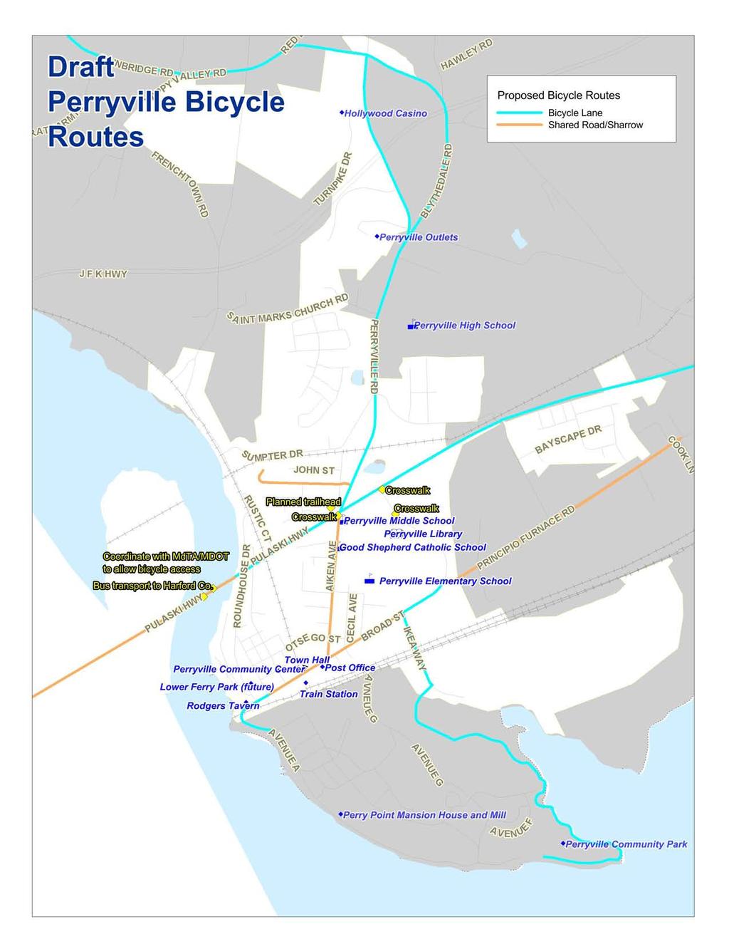
1 A Partnership of the Town of Perryville and WILMAPCO Perryville Transit Oriented Development & Greenway Plan Why plan for TOD and Greenways? Identify strategies to enhance community character in Perryville Promote opportunities for transit supportive redevelopment Promote local and regional walking, bicycling and transit Support local and state Smart Growth policies and economic development initiatives Embrace Perryville s history while preparing for its future Why TOD? Support growth in transit ridership Expanded rail transit identified as priority Station parking at capacity Why greenways (plus bike routes and sidewalks)? Transportation benefits Public health and quality of life benefits Environmental benefits Economic benefits Outreach to Date Public Workshops o October 12, 2010 o February 10, 2011 TOD Advisory Committee o September 14, 2010 o January 11, 2011 Greenway Committee o September 23, 2010 o February 24,


")

2 concept plan: option 1 - phase perryville tod -Min Walk 8 4 Aiken Ave Otsego St 1 4. Story Mixed-use - Ground level retail along Broad St - 4 Story residential wrapper - level garage - 4 spaces 9 Broad St 2 Susquehanna River 3 Program Key 1 Town Hall 2 Train Station 3 Rogers Tavern 4 Police Station Mixed-Use (Office) Mixed-Use (Residential) Restaurant 8 Day Care 9 Outdoor Amphitheater Perry Point N architecture. planning. interiors


3 concept plan: option 1 - parking perryville tod Otsego St 1 Aiken Ave 2 4 Broad St 3 Susquehanna River Parking 1 Area parking spaces 3 street parking 28 Total Spaces 2 Area 2 44 parking garage 10 street parking 4 Total Spaces 3 Area parking garage 20 parking spaces 140 Total Spaces 4 Area 4 0 parking spaces 9 street parking 139 Total Spaces Area 140 parking spaces 24 street parking 14 Total Spaces Perry Point N architecture. planning. interiors


")


4 concept plan: option 1 - phase perryville tod Min Walk Aiken Ave Otsego St 1 Additional 1 paring spaces 9 Broad St 2 Susquehanna River 3 Program Key 1 Town Hall 2 Train Station 3 Rogers Tavern 4 Police Station Mixed-Use (Office) Mixed-Use (Residential) Restaurant 8 Day Care 9 Outdoor Amphitheater 10 Townhomes Perry Point N architecture. planning. interiors

 Mixed-Use (Residential) Restaurant 8 Day Care 9 Outdoor Amphitheater Perry Point N 100 0 0 100 400 2")
5 concept plan: option 2 - phase perryville tod -Min Walk 8 4 Aiken Ave Otsego St 1 4. Story Mixed-use - Ground level retail along Broad St - 4 Story residential wrapper 9 Broad St 2 4 Story Residential/Parking Garage - 4 Story residential wrapper - level garage - 44 spaces Susquehanna River 3 Program Key 1 Town Hall 2 Train Station 3 Rogers Tavern 4 Police Station Mixed-Use (Office) Mixed-Use (Residential) Restaurant 8 Day Care 9 Outdoor Amphitheater Perry Point N architecture. planning. interiors


 Mixed-Use (Residential) Restaurant 8 Day Care 9 Outdoor")
6 concept plan: option 3 - phase perryville tod -Min Walk 8 4 Aiken Ave Otsego St 1 4. Story Mixed-use - Ground level retail along Broad St - 4 Story residential wrapper - Level garage - 3 spaces - 2 surface parking spaces 9 Broad St 2 Susquehanna River 3 Program Key 1 Town Hall 2 Train Station 3 Rogers Tavern 4 Police Station Mixed-Use (Office) Mixed-Use (Residential) Restaurant 8 Day Care 9 Outdoor Amphitheater Perry Point N architecture. planning. interiors

7 concept plan: option 4 - phase perryville tod -Min Walk 8 4 Aiken Ave Otsego St 1 4. Story Mixed-use - Ground level retail along Broad St - 4 Story residential wrapper 9 Broad St 2 4 level garage spaces or level garage - 0 spaces Susquehanna River 3 Program Key 1 Town Hall 2 Train Station 3 Rogers Tavern 4 Police Station Mixed-Use (Office) Mixed-Use (Residential) Restaurant 8 Day Care 9 Outdoor Amphitheater Perry Point N architecture. planning. interiors
8
9
10
11 Response Sheet Perryville Planning Survey - Responses PURPOSE: We are seeking your thoughts on transportation and land use in your area. Perryville and the Wilmington Area Planning Council would like your help in identifying transportation problems and needed improvements for Perryville. TRANSPORTATION ISSUES 1. What are your greatest transportation concerns for the downtown Perryville area? Parking Lack of parking (response from 2 surveys) Parking for train users (response from 4 surveys) Residential parking Commuter parking Roadway Narrow roadways Added congestion Rush hour traffic congestion (response from 2 surveys) Transit Public transportation Trolley service and more places to go. Ferry from/to Havre de grace and Garrett Island. Need for more Amtrak Scheduled stops Bus service to train station and link to other stations Better use of rail line Other Where is the downtown area not really identifiable. Create connectivity throughout downtown Perryville for bikes, vehicles and pedestrians Balance need for parking with need for parks, open space, and business density 2. Describe what transportation facilities and services are needed in Perryville (i.e. roads, sidewalks, transit, commuter rail, street lights, greenway connections, parking, intersection improvements)? Bicycle and Pedestrian Sidewalks (response from surveys) Greenway connections Bike lanes Sidewalks on Roundhouse Drive (both sides) Access to Lower Ferry Park from Roundhouse Drive Sidewalks and bike paths are the most important. These should connect destinations like parks, waterfront, train station, etc. Bike accessibility Sidewalks and greenways (connect town with natural areas around town) Continue sidewalks and greenways for pedestrian use Parking Parking (response from surveys) Garage with retail component Additional parking at MARC station and waterfront Parking garage at train station Full parking plan considering future growth Parking at MARC station Road and streetscape
12 Transit Improvement to Broad/Aiken intersection Road upgrades Intersection improvements (Rt 40, Aikens & Broad, etc.) All improvements should include attractive and adequate/relevant street lights Street lights at Lower Ferry Park Lights Decorative street lighting down Aiken Ave. Shopping Transit Commuter rail Bus Rail for Baltimore/Philadelphia - local and Amtrak Local trolleys with some establishments for them to go to Outlets and Casino Transportation service into Havre de Grace, Port Deposit Train service connecting North to Elkton/Philly Water taxi to link Perryville and Havre de Grace Commuter rail 3. How would you rate the following transportation issues and facilities in Perryville? Very Good Very Bad Sidewalks Bike paths and lanes Bus transit Traffic speeds Parking Truck traffic Traffic congestion PUBLIC TRANSIT ISSUES. To what destinations, if any, would you like to see public bus service? Casino ( survey responses) Train station (3 survey responses) Havre de Grace (4 survey responses) Perry Point (2 survey responses) Outlets (3 survey responses) Newark (2 survey responses) Park Employer areas Harford County to pick up Baltimore lines Tavern Furnace Bay Golf Course Elkton Medical building on Rt 40 Bel Air Corner of 40 and Aiken Future Woodlands Site Shopping centers on Rt 40 at Woodlands when developed Delaware, Wilmington, Philadelphia, New York Baltimore, Washington DC What would be the purpose of your trip? 4 Work Shopping 0 School 9 Social/Recreation Medical/Dental 1 Other Farmers Market TRANSIT ORIENTED DEVELOPMENT ISSUES. How would you rate the following downtown character issues for transit oriented development Perryville?
13 Most Greatest support opposed Mixed use development with ground floor & upstairs residential/office Preserve existing historic buildings and make new development fit in Have variety of housing types (i.e. apartments, condos, single family) Emphasize quality architecture design for new downtown development Increase retail & services Infill development BICYCLING ISSUES. Describe how often you currently travel by bicycle? 0 Daily x per week 2 1-3x per month 4 Very rarely Never 8. Describe your bicycle trip purpose. (Check all that apply) 2 Work 0 School 3 Shopping Recreation/exercise 0 Other 9. List the reason(s) you don t bicycle or bicycle more often: Too far Lack of bicycle storage/parking 2_ Concerns about personal safety (from assaults) _1_ Concerns about crashes 3_ Lack of bikeways Weather/darkness 2_ Need access to car 2_ Other: Age, time (car is faster), bike was stolen months ago, too lazy, just like to run or walk WALKING ISSUES 10. Describe how often you currently walk in Perryville? 1 Daily x per week 3 1-3x per month Very rarely 2 Never 11. Describe your walking trip purpose. (Check all that apply) 2 Work 0 School 3 Shopping 8 Recreation/exercise 1 Other Dining 12. List the reason(s) you don t walk or walk more often: Too far Concerns about personal safety (from assaults) _1_ Concerns about crashes _2 Lack of sidewalks/greenways Weather/darkness 0 Need access to car 0 Other _Nowhere to go, too lazy, time OTHER COMMENTS 13. What is Perryville s single greatest need? Economic Development and Land Use Mixed use Remove trailer park Downtown area recognizable Waterfront amenities Redevelopment of old downtown areas and surrounding residential areas Razing of rent-a-room crime ridden motels on US 40 More businesses downtown Shopping, commerce A "Main Street" Shops Restaurant Economic development - plans don't work without an organization to drive the economics and attract business
14 Shops to provide basic needs and comforts, particularly in the downtown i.e. cards, full deli, coffee, bakery, etc. More businesses (w/ supportive parking) to draw people downtown. This is important to downtown revitalization Transportation and Other Overall planning for responsible/sustainable growth Continuity Parking, more room on Aiken Ave Biking 14. What do you like best about Perryville? Scale and atmosphere Location - on the waterfront but with easy access to I-9, Rt 40 and MARC Historic character It's small town feel and access to the waterfront The potential! Natural resources (water, woodlands, etc.) Small town appeal Location (river, I-9, Rt. 40, rail access) Remains a small town in atmosphere Great parks Library Historic architecture Waterfront/I-9 access Small town charm - friendly New library Bay and riverfront 1. Please provide us with any comments that will assist us in Perryville transportation and transit oriented development, and greenway planning. Perryville is growing away from the railroad station and old town center. Efforts are needed to redirect efforts to older sections of town. Need a water taxi system Cab company I have some concerns with the concept plans presented. First, I don't like the idea of giving up public land for residential uses. Second, while the plan may incorporate good planning principals, I'm looking at the reality of putting the plans into action and see many challenges that could take many years to complete. I would rather see currently owned public lands used primarily for public uses.
Perryville TOD and Greenway Plan
 Perryville TOD and Greenway Plan Greenway Glossary Pathway: A bicycle and pedestrian path separated from motorized vehicular traffic by an open space, barrier or curb. Multi-use paths may be within the
Chapter 5 Future Transportation
 Chapter 5 Future Transportation The Future Land Use Plan identifies the desired land use designations. The land uses desired for Crozet depend, in large part, on the success of the transportation system,
Cecil County, Maryland. Bicycle Master Plan
 Cecil County, Maryland Bicycle Master Plan Overview Background Schedule and Tasks Network Assessment Network Identification Next Steps Schedule and Tasks May 2011 Plan Scoping and Mobilization Data Collection
Bus Rapid Transit Plans
 Twin Cities Region Bus Rapid Transit Plans ULI Minnesota Workshop Connecting Bus Rapid Transit to the Community December 15, 2009 John Levin Director of Service Development Metro Transit Metropolitan Area
Town of Ashland. Downtown Planning Initiative 2 nd Community Workshop. March 29, Presented by:
 Town of Ashland Downtown Planning Initiative 2 nd Community Workshop Presented by: March 29, 2018 Agenda Tonight Review project & goals Recap 1st workshop (September 18, 2017) Present design alternatives
Vision: Traditional hamlet with an attractive business/pedestrian friendly main street connected to adjacent walkable neighborhoods
 N D. Focus Area II Vision: Traditional hamlet with an attractive business/pedestrian friendly main street connected to adjacent walkable neighborhoods Transit Road Focus Area II is located in the Hamlet
WILMAPCO Public Opinion Survey Summary of Results
 Wilmington Area Planning Council WILMAPCO Public Opinion Survey Summary of Results Prepared by: 2955 Valmont Road, Suite 300 Boulder, Colorado 80301 t: 303-444-7863 f: 303-444-1145 www.n-r-c.com Table
Table #6 VISION CHARACTERISTICS
 Table #6 VISION White Flint is a place to live, work, play, shop, and walk with sufficient density to encourage quality redevelopment. Vibrant streets and consistent streetscapes are important. CHARACTERISTICS
Executive Summary Route 30 Corridor Master Plan
 Route Corridor Master Plan Project Overview The Route Corridor Master Plan is a coordinated multimodal transportation and land use plan for the entire stretch of Route through East Whiteland Township,
Ann Arbor Downtown Street Plan
 1 Ann Arbor Downtown Street Plan Public Workshop #1 We know that. 2 Public right-of-way (streets, sidewalks, and alleys) make up 30% of the total District area of downtown. Streets need to provide mobility
CONNECTING PEOPLE TO PLACES
 CONNECTING PEOPLE TO PLACES 82 EAST BENCH MASTER PLAN 07 Introduction The East Bench transportation system is a collection of slow moving, treelined residential streets and major arteries that are the
North Shore Transportation Improvement Strategy
 North Shore Transportation Improvement Strategy Preliminary, Near-term Recommendation 2016 April Transportation Improvement Strategy (TIS) Comprehensive and Analytical A multi-modal transportation strategy
METRO RTA TRANSIT MASTER PLAN. May 25-26, 2011
 METRO RTA TRANSIT MASTER PLAN May 25-26, 2011 WHAT IS THE TRANSIT MASTER PLAN? A twenty-year plan for METRO RTA What will METRO look like in 2031? 1 TRANSIT TECHNOLOGIES 2 TRANSIT TECHNOLOGIES Transit
In station areas, new pedestrian links can increase network connectivity and provide direct access to stations.
 The Last Mile Planning for Pedestrians Planning around stations will put pedestrians first. Making walking to stations safe and easy is important; walking will be a part of every rapid transit Accessible
Roads and Vehicular Traffic Design Principles. Roads and Vehicular Traffic Recommendations
 CIRCULATION AND PARKING roads and vehicular traffic The Campus Master Plan updates the campus transportation network through a multi-modal approach that encourages walking and biking while improving vehicular
Eliminate on-street parking where it will allow for a dedicated bus only lane %
 Traffic Dashboard Priorities Survey Responses Introduction 1) Are you familiar with bus rapid transit (BRT)? a. No, BRT is new to me. 597 23.5% b. I ve heard of BRT, but I don t know much about it. 1,136
Nanaimo Transportation Master Plan. Phase 1 Consultation Summary
 Nanaimo Transportation Master Plan Phase 1 Consultation Summary Transportation Advisory Committee Meeting Wednesday December 12, 2012 Agenda Study Update Phase 1 Consultation Process Phase 1 Consultation
Approved Developed by WILMAPCO. In partnership with The Town of Perryville, Maryland Cecil County
 A Plan for Walking and Bicycling in the Town of Perryville PERRYVILLE GREENWAY PLAN Developed by WILMAPCO In partnership with The Town of Perryville, Maryland Cecil County With technical assistance from
What are the Qualities that make Newark a Bicycle Friendly Community? What are aspects that make Newark less Bicycle Friendly?
 What are the Qualities that make Newark a Bicycle Friendly Community? Many stores are within biking distance (1) Lots of bike lanes and new trail Existing bike routes (2) Designated bike lanes on Del ave.
Welcome. Wilmington Transit Moving Forward Workshop Presentation. October 16, 2013
 Welcome Wilmington Transit Moving Forward Workshop Presentation October 16, 2013 Project Purpose Evaluate recommendations from previous studies Wilmington Downtown Circulation Study (WDCS) 2012 State Smart
STONY PLAIN ROAD STREETSCAPE
 Jasper Place Revitalization Strategy: Vision The people involved in the Jasper Place Revitalization Strategy envision: Goal 1: Feeling safe in our community Create a community where feeling safe is common--where
City of Wilsonville 5 th Street to Kinsman Road Extension Project
 City of Wilsonville 5 th Street to Kinsman Road Walking Tour & Neighborhood Workshop Summary Report Public Outreach Overview On July 18 th, 2017, the City of Wilsonville hosted a neighborhood walking tour
San Jose Transportation Policy
 San Jose Transportation Policy Protected Intersections in LOS Policies to Support Smart Growth Presented by: Manuel Pineda City of San Jose Department of Transportation Bay Area Map San Francisco Oakland
JOINT PARTNERSHIPS: Working Together To Support Light Rail in Santa Monica
 JOINT PARTNERSHIPS: Working Together To Support Light Rail in Santa Monica ITY OF ANTA MONICA RAIL-VOLUTION / OCTOBER 17, 2012 SARAH LEJEUNE, PRINCIPAL PLANNER, STRATEGIC + TRANSPORTATION PLANNING DIVISION
Bus Rapid Transit ALTERNATIVES ANALYSIS. Open House
 Bus Rapid Transit ALTERNATIVES ANALYSIS Open House June 23, 2015 Open House Meeting Agenda Agenda Introductions What is BRT? Project Goals Study Tasks Next steps Discussion PVTA Bus Rapid Transit Study
Tourists simply won t go to a city or town that has lost its soul. Arthur Frommer
 Among cities and towns with no particular recreational appeal, those that preserve the past continue to enjoy tourism. Those that haven t receive almost no tourism at all. Tourists simply won t go to a
Illustrated Principles of Good Planning
 Illustrated Principles of Good Planning The Miami 21 Zoning Code incorporates time-tested planning principles into the zoning regulations of our City. These are principles that make for better neighborhoods,
Transportation Corridor Studies: Summary of Recommendations
 Transportation Corridor Studies: Summary of Recommendations Route 4 Corridor Study: Route 10 Corridor Study: Route 44 Corridor Study: Route 175 Corridor Study: Route 5/15 Corridor Study: Rentschler Field
Cherry Creek Transportation and Land Use Forum September 25, 2013 Meeting Summary
 Cherry Creek Transportation and Land Use Forum September 25, 2013 Meeting Summary I. LEAD-IN TO SMALL GROUP DISCUSSION, POLLING AND STEERING COMMITTEE/TECHNICAL TASK FORCE DISCUSSION The meeting began
Public Workshop #2. September 14, 2016
 Public Workshop #2 September 14, 2016 Agenda Welcome Project Overview Where We Have Been Alternatives for State Street Land Use Street Design Next Steps 2 Project Overview Create a Vibrant State Street
Charrette #1 Keypad Polling Results. June 27, 2012
 Charrette #1 Results June 2, 2012 1. My affiliation with Opelika Road is (Choose all that apply) 1 2 Business owner Property owner 12 4 Business owner Property owner 2 1 2 2 Nearby resident Business patron
A CHANGING CITY. of Edmonton, it is essential that it reflects the long-term vision of the City.
 A CHANGING CITY By the year 2040, Edmonton will be home to more than 1 million people. To accommodate growth and support a healthy and compact city, we need a new approach to development/redevelopment
THIRD&GRAND. Public Workshop #1. Transportation Hub Area Plan. June 12, 2013
 Transportation Hub Area Plan Public Workshop #1 June 12, 2013 Agenda Study Background Who is Involved Process and Schedule Planning Area and Project Site The Opportunity Site Analysis Land Use/Zoning Transportation
Chapter 7. Transportation. Transportation Road Network Plan Transit Cyclists Pedestrians Multi-Use and Equestrian Trails
 Chapter 7 Transportation Transportation Road Network Plan Transit Cyclists Pedestrians Multi-Use and Equestrian Trails 7.1 TRANSPORTATION BACKGROUND The District of Maple Ridge faces a number of unique
DATE: June 22, General Release SUBMITTED BY: LAND DEVELOPMENT SERVICES. RE: City Centre Survey Results
 DATE: June 22, 2018 TO: General Release SUBMITTED BY: LAND DEVELOPMENT SERVICES RE: City Centre Survey Results The following is a summary of preliminary findings for the Community Identity and Vision survey.
Corridor Vision Workshop Summary James Madison Elementary February 22,2018
 Corridor Vision Workshop Summary James Madison Elementary February 22,2018 WHY DEVELOP THIS STUDY? Ogden City is planning for better connectivity and access to jobs and housing. Working with area partners,
Circulation in Elk Grove includes: Motor vehicles, including cars and trucks
 Circulation, as it is used in this General Plan, refers to the many ways people and goods move from place to place in Elk Grove and the region. Circulation in Elk Grove includes: Motor vehicles, including
Overview: Phase 3 Draft Development and Circulation Plans, White Bear Station
 Overview: Phase 3 Draft Development and Circulation Plans, White Bear Station This overview explains how to get more involved and provides information on the Phase 3 draft circulation and development plans
Fitting Light Rail through Well-established Communities
 Fitting Light Rail through Well-established Communities San Francisco 2008 Michael D. Madden Chief, Project Development, Maryland Transit Administration Project Setting Located inside the Capital Beltway
Providing an Efficient and Multi-modal Transportation System
 Providing an Efficient and Multi-modal Transportation System Welcome and Introductions The Plan Process Transportation Overview Workshop Discussions Report Out and Next Steps AGENDA Comprehensive Plan
COMPLETE STREETS PLANNER S PORTFOLIO
 COMPLETE STREETS PLANNER S PORTFOLIO ISSUE 3 APRIL 2016 PLANNER S PORTFOLIO COMPLETE STREETS 1 2 6 10 14 OVERVIEW MATURE NEIGHBORHOODS GROWING SUBURBS CENTRAL PLACES ACTIVITY CORRIDORS Planner s Portfolio
Y O R K R O A D. Baltimore, Maryland. ULI Technical Assistance Panel June 18 & 19, York Road Technical Assistance Panel
 Y O R K R O A D Baltimore, Maryland ULI Technical Assistance Panel June 18 & 19, 2013 The York Road TAP Team ULI York Road TAP Chairperson Addison Palmer, STV Incorporated Technical Assistance Panelists
MASTER BICYCLE AND PEDESTRIAN PLAN
 VILLAGE OF NORTHBROOK MASTER BICYCLE AND PEDESTRIAN PLAN DRAFT PLAN OPEN HOUSE May 2, 2018 AGENDA 1. Community Engagement 2. Vision and Goals 3. General Structure of Plan 4. Recommendations Overview 5.
Appendix A-K Public Information Centre 2 Materials
 Appendix A-K Public Information Centre 2 Materials Our Rapid Transit Initiative Make an impact on the future of transit Join the discussion on Rapid Transit in London You re invited to a Public Information
COWETA HIGH SCHOOL AND EAST HIGHWAY 51
 COWETA HIGH SCHOOL AND EAST HIGHWAY 51 Lack of sidewalks along Ben Lumpkin Rd. Lack of crosswalks and ramps at intersection. Hwy 51 is wide to cross as a pedestrian. No ADA compliance or connection to
PRIORITIES RESULTS YOUR PRIORITIES FOR BRIDGEPORT 5% 4% 13% RESIDENTIAL CHOICES TRAILS & PARKS
 Community Visioning Open House The Community Visioning Open House was held on January, 31st 2018 at Harrisburg Area Community College (HACC), Lancaster Campus. Approximately 80 people attended this Open
MEETING Agenda. Introductions. Project Overview. Key Study Components. Alternative Station Concepts. Preferred Station Concept. Next Steps.
 City GARLAND Council ROADVISION Briefing STUDY VISION STUDY Dallas, TX April 8, 2010 1 1 MEETING Agenda Introductions Project Overview Key Study Components Alternative Station Concepts Preferred Station
Bicycle and Pedestrian Connectivity Study Phase 2
 Connectivity Study Phase 2 Process PROCESS OUTCOMES Phase Prepared By STEP I Public Participation and Outreach 1. RTP Outreach activities, and development of the Bike and Ped Task Force Phase 1 2011 OCPC
Centennial Neighbourhoods Transportation Management Plan Summary of Phase 1 Consultation. Overview of Issues
 1 Centennial Neighbourhoods Transportation Management Plan Summary of Phase 1 Consultation The Centennial Neighbourhoods Transportation Management Plan (CNTMP) is being undertaken to support the Secondary
THE ALAMEDA CONCEPT DESIGN COMMUNITY MEETING 3. A Plan for The Beautiful Way JANUARY 28, 2010
 CONCEPT DESIGN COMMUNITY MEETING 3 JANUARY 28, 2010 AGENDA INTRODUCTION COMMUNITY INPUT ROADWAY STUDIES STREETSCAPE DESIGN STATIONS DISCUSSION SUMMARY AND DISCUSSION NEXT STEPS CLOSE INTRODUCTION SCHEDULE
21.07 TRANSPORT CONNECTIVITY AND INFRASTRUCTURE
 21.07 TRANSPORT CONNECTIVITY AND INFRASTRUCTURE 21.07-1 Connectivity and Choice Transport connectivity and mode choice are critical to achieving productive, sustainable and socially just cities. Travel
Downtown Naples Mobility and Connectivity Study. Naples City Council Presentation January 2017
 Downtown Naples Mobility and Connectivity Study Naples City Council Presentation January 2017 Agenda 1. Introduction 2. Scope Review 3. Project Schedule 4. Existing Conditions 5. Public Charrette 6. Mobility
Rochester Downtown Bicycle Study 2009
 Rochester Downtown Bicycle Study 2009 Relationship of ROCOG Long Range Transportation Plan to Rochester Comprehensive Plan Regional Long Range Transportation Plan (LRTP) is prepared under the auspices
Hennepin Avenue Reconstruction Washington Avenue to 12 th Street
 CITY OF MINNEAPOLIS Hennepin Avenue Reconstruction Washington Avenue to 12 th Street April 2016 1 Upcoming Opportunities Public Meeting #2 April 25, 2016 Minneapolis Central Library Doty Board Room Repeat
CHAPTER 3: Vision Statement and Goals
 Davidson Walks & Rolls: Active Transportation Master Plan CHAPTER 3 Contents: Overview Vision Statement Measurable Goals Public Outreach CHAPTER 3: Vision Statement and Goals Overview The vision statement
Omaha s Complete Streets Policy
 Omaha s Complete Streets Policy (Adopted August 2015) VISION To create great places and enhance our quality of life, the City of Omaha will provide safe, accessible streets for all users. Complete Streets
Advanced Transit Oriented Developments (ATODs) - Defined
 - Defined") Advanced Transit Oriented Developments (ATODs) - Defined Work previously undertaken at Florida International University (FIU) in the Lehman Center for Transportation Research (LCTR), the School of Architecture
Advanced Transit Oriented Developments (ATODs) - Defined Work previously undertaken at Florida International University (FIU) in the Lehman Center for Transportation Research (LCTR), the School of Architecture
San Francisco Asian, Inc.
 San Francisco Asian, Inc. Plan Bay Area Community-Based Outreach Outreach area: South of Market/Tenderloin in San Francisco, California Outreach description: Outreach in April and May 2011 through door
WELCOME. Purpose of the Open House. Update you on the project. Present a draft recommended plan. Receive your input
 WELCOME Purpose of the Open House The Town of Smiths Falls has initiated the Beckwith Street Redevelopment Plan that includes the preparation of a streetscape functional design for the renewal of Beckwith
Orinda Bicycle, Trails and Walkways Master Plan
 Orinda Bicycle, Trails and Walkways Master Plan Public Meeting October 15, 2008 Presented by: Ian Moore, Alta Lauren Ledbetter, Alta Bruce Wolff, Alta Introductions City of Orinda Monica Pacheco, Assistant
TOD COVER. Header. Lessons Learned. Results of FTA s Listening Sessions With Developers, Bankers, and Transit Agencies on Transit Oriented Development
 Header COVER TOD T R A N S I T O R I E N T E D D E V E L O P M E N T Lessons Learned Results of FTA s Listening Sessions With Developers, Bankers, and Transit Agencies on Transit Oriented Development U.S.
Slide. Too close together; Don't like the garages in front; Front-facing garages are not nice; Bland; Looks like suburbs; Only see garages
 1 Slide Visual Preference Survey Results Like driveways and less density; Everything looks squeezed in; Street parking is a turn-off; East Coast look; I like the porches; Garages should be in alleys; Too
Project Narrative. Albuquerque, NM. July 31, 2015
 Project Narrative Albuquerque, NM July 31, 2015 1 Project Identification As the first bus rapid transit (BRT) project in New Mexico, the Albuquerque Rapid Transit (ART) line will run through the heart
Ulster County Non-motorized Transportation Plan
 Ulster County Non-motorized Transportation Plan NTAC Meeting NOTES Ulster County Community College Date 08.29.07 Time: 1:00 p.m. - 3:00 p.m. Agenda Welcome /Intro Project Status Report o Project is on
Irondale on the Move Public Outreach Summary to Date. July 8, 2015
 Irondale on the Move Public Outreach Summary to Date July 8, 2015 Visioning Survey Results 467 Total Responses What do you consider to be the top two strengths of the City of Irondale from your perspective?
Pedestrian. Identifying Important Pedestrian Routes. 7 Pedestrian CHAPTER 7
 CHAPTER 7 Pedestrian T he City of Decatur is a prime location for walking. Historic houses, tree lined streets, a range of fine shopping and restaurants, and a conveniently small size all help create an
Planning Regionally With Transit
 Planning Regionally With Transit Nathan Coats Director of Operations CTAA Expo 2015 Tampa Began 1992. Serves eastern Cache County to Preston, ID. Population- 115,000 34 bus fleet, 26 fixed route buses;
TRANSPORTATION & ACCESS
 STATE OF CENTER CITY PHILADELPHIA TRANSPORTATION & ACCESS Matt Stanley Center City is well-positioned at the center of an extensive, multi-modal transportation system. It is located just seven miles from
Chapter 2. Bellingham Bicycle Master Plan Chapter 2: Policies and Actions
 Chapter 2 Bellingham Bicycle Master Plan Chapter 2: Policies and Actions Chapter 2: Policies and Actions The Bicycle Master Plan provides a road map for making bicycling in Bellingham a viable transportation
Areas for Redevelopment or New Development:
 Small Group Exercise Summary Areas for Redevelopment or New Development: 1. Downtown a. Job Resource Center b. Community Activities / Activities to draw youth & millennials c. Need for additional parking
95 th Street Corridor Transportation Plan. Steering Committee Meeting
 95 th Street Corridor Transportation Plan Steering Committee Meeting August 11, 2014 PROJECT OBJECTIVES Develop a Transportation and Economic Plan for the 95 th Street Corridor Improve public transit efficiency
Capital and Strategic Planning Committee. Item III - B. April 12, WMATA s Transit-Oriented Development Objectives
 Capital and Strategic Planning Committee Item III - B April 12, 2018 WMATA s Transit-Oriented Development Objectives Page 24 of 76 Washington Metropolitan Area Transit Authority Board Action/Information
Mainstreet Master Plan Land Use
 Mainstreet Master Plan 04 Land Use Top Recommendations Active Uses: Promote active ground-floor uses such as retail, restaurants, galleries and personal services with interactive storefronts for Mainstreet
Improving Pedestrian Access to Transit: The Sacramento Pedestrian Master Plan
 Improving Pedestrian Access to Transit: The Sacramento Pedestrian Master Plan Matt Haynes Fehr & Peers Associates San Francisco, California Rail~Volution 2005 Presentation Outline Policies What are most
New Park Avenue Corridor West Hartford
 New Park Avenue Corridor West Hartford Current TOD Investment in the Corridor Mixed-use building currently under development by the Trout Brook Realty Advisors: a separate non-profit corporation, established
Speed Limits Study and Proposal. Public Input Session: 8/14/13
 Speed Limits Study and Proposal Public Input Session: 8/14/13 Why is Decatur a unique place for this project? First Community Transportation Plan in the nation with a Health Impact Assessment. Strong sense
Presentation Comments and Questions
 Presentation Comments and Questions The community had a number of questions regarding the master plan process and operational issues in and around the MARC rail station areas. The bullet points below are
Land Use and Urban Design
 35th ST 36th ST 37th ST 39th ST 40th ST 41st ST 34th ST 35th ST 36th ST 37th ST 38th ST 39th ST 40th ST Land Use and Urban Design Map 3: Corridors Land uses have evolved over many decades to accommodate
MARC Rail Communities Plan Working Draft December 21, 2017
 MARC Rail Communities Plan Working Draft December 21, 2017 Staff Recommendation Approve the Working Draft of the MARC Rail Communities Sector Plan as the Public Hearing Draft Set the public hearing date
MIXED USE AND STREETSCAPE INTEGRATION Avondale Will Basil Juliana Zannotto
 MIXED USE AND STREETSCAPE INTEGRATION Avondale Will Basil Juliana Zannotto Creating new development so that people will stop and see what Avondale has to offer The goal for my project was simple. I wanted
EXECUTIVE SUMMARY. Vision
 Vision Walking and bicycling in Salt Lake City will be safe, convenient, comfortable, and viable transportation options that connect people to places, foster recreational and economic development opportunities,
Appendix C 3. Bicycle / Pedestrian Planning
 Appendix C 3. Bicycle / Pedestrian Planning BICYCLE/PEDESTRIAN PLANNING 2005 Master Plan GOAL: Provide for safe and convenient bicycle and pedestrian circulation throughout the City. Develop a city-wide
Land Use and Transportation Town Hall September 17, 2018
 Land Use and Transportation Town Hall September 17, 2018 Welcome! Tonight s Agenda: 7:00-7:30 OVERVIEW PRESENTATIONS 7:30-8:15 BREAKOUT SESSIONS 8:15 - End TOWN HALL CITIZEN S TIME Purpose of Tonight s
About the Wilmington Downtown Circulation Study
 About the Wilmington Downtown Circulation Study Part of the Wilmington i Initiatives partnership Wilmington Area Planning Council City of Wilmington Delaware Department of Transportation Delaware Transit
Introduction. Who is WILMAPCO. Why are walkable communities important
 Walkable Community Workshops Round 1 April 2005 SPONSORED BY WILMAPCO AND CCOBH CITY OF NEW CASTLE EDGEMOOR GARDENS CIVIC ASSOCIATION WITH FUNDING BY DELAWARE DEPARTMENT OF TRANSPORTATION AND THE DELAWARE
Cottage Grove Road Activity Centers Plan
 Cottage Grove Road Activity Centers Plan Cottage Grove Road January 31, 2107 Kick Off Meeting Input Cottage Grove Road Corridor Visioning Exercise What would you like to see in 20 years? 10 Years? A vision
ACTIVE TRANSPORTATION
 ACTIVE TRANSPORTATION Mobility 2040 Supported Goals Improve the availability of transportation options for people and goods. Support travel efficiency measures and system enhancements targeted at congestion
CITY OF COCOA BEACH 2025 COMPREHENSIVE PLAN. Section VIII Mobility Element Goals, Objectives, and Policies
 CITY OF COCOA BEACH 2025 COMPREHENSIVE PLAN Section VIII Mobility Element Goals, Objectives, and Policies Adopted August 6, 2015 by Ordinance No. 1591 VIII MOBILITY ELEMENT Table of Contents Page Number
Obey Creek PEDESTRIAN CIRCULATION EAST WEST PARTNERS PEDESTRIAN CIRCULATION CREEK SIDE LANE SLIP STREET SCOTT MURRAY MAIN STREETS EAST/WEST
 THE VILLAGE AT PEDESTRIAN CIRCULATION MAIN STREETS NORTH/SOUTH MAIN STREETS EAST/WEST SLIP STREET CREEK SIDE LANE PEDESTRIAN CIRCULATION DESCRIPTION: Circulation through the downtown of is organized by
CITY OF PITTSBURGH. City of Pittsburgh Active Transportation Profile REGIONAL ACTIVE TRANSPORTATION PLAN FOR SOUTHWESTERN PENNSYLVANIA
 REGIONAL ACTIVE TRANSPORTATION PLAN FOR SOUTHWESTERN PENNSYLVANIA 1 2 ACTIVE TRANSPORTATION AT A GLANCE Trails & Bike Routes 270 miles 28 miles 41 miles 24 miles 3 F A C I L I T I E S Facility Metrics
Transportation Assessment
 Transportation Assessment Midtown Open House February 10, 2018 Overview Midtown in Focus Overview & Purpose of Today Transportation Assessment overview Summary of Transportation work to date Review & Analysis
Complete Streets Successes, Opportunities, and Challenges
 Complete Streets Successes, Opportunities, and Challenges Juliet Walker, Transportation Planner, City of Portsmouth Rob Houseman, Director of Planning and Development, Town of Wolfeboro Chris Parker, Director
Richmond Connects Visioning Update
 Richmond Connects Visioning Update To date there have been four elements of the visioning process: Vision20 Night at Byrd Theatre on May 3rd Advisory Committee Meeting on May 12 th Public Visioning Workshop
Plant City Walk-Bike Plan
 Plant City Walk-Bike Plan Plant City Commute Mode Share 2.2% 1.4% 2.9% Drove alone 10.2% Carpooled Public transportation (0.1%) Walked Used a Bike (0.4%) 82.9% Taxicab, motorcycle, or other means Worked
Unlocking Economic and Community Benefits Through Transportation Planning
 Unlocking Economic and Community Benefits Through Transportation Planning Power of Place Summit May 11, 2012 Aquidneck Island Planning Commission Opening Remarks/Project Background Tina Dolen, Executive
Elmhurst Metra Station. Public Hearing Wednesday - November 30, 2016
 Elmhurst Metra Station Public Hearing Wednesday - November 30, 2016 Agenda Introduction to Hearing Format - Presentation (20 Minutes) - Exhibits/Workstations - Record (Comment Cards, Court Reporter)
Solana Beach Comprehensive Active Transportation Strategy (CATS)
") Solana Beach Comprehensive Active Transportation Strategy (CATS) 3.0 Goals & Policies The Solana Beach CATS goals and objectives outlined below were largely drawn from the Solana Beach Circulation Element
Solana Beach Comprehensive Active Transportation Strategy (CATS) 3.0 Goals & Policies The Solana Beach CATS goals and objectives outlined below were largely drawn from the Solana Beach Circulation Element
What do you like about the Woodland District? What brings you here? (places, activities, etc.)
") What do you like about the Woodland District? What brings you here? (places, activities, etc.) Group Dave Response/Notes Services/shopping/banking/med Transit ical Nice streets tree lined Access to I 5
What do you like about the Woodland District? What brings you here? (places, activities, etc.) Group Dave Response/Notes Services/shopping/banking/med Transit ical Nice streets tree lined Access to I 5
PEDESTRIAN ACTION PLAN
 ATTACHMENT 2 CITY OF SANTA MONICA PEDESTRIAN ACTION PLAN CITY OF SANTA MONICA PEDESTRIAN ACTION PLAN This page intentionally left blank EXECUTIVE SUMMARY CHAPTER 1 EXECUTIVE SUMMARY Setting the Stage
University of Michigan & Urban Land Institute Real Estate Forum. Mary Beth Graebert Michigan State University
 University of Michigan & Urban Land Institute Real Estate Forum Mary Beth Graebert Michigan State University November 20, 2013 Michigan State University Land Policy Institute Strong focus on research and