This is for information, however, staff is seeking input on the transportation project selection criteria.
|
|
|
- Derrick Green
- 5 years ago
- Views:
Transcription

1 Land Use and Natural Resources Committee Meeting Date: 9/6/2018 Agenda Item No.: 2018-September-2. Subject: 2020 Metropolitan Transportation Plan/Sustainable Communities Strategy: Discussion Scenario (Est. time: 45 minutes) Informa on Prepared by: Clint Holtzen A achments: Yes Approved by: Kacey Lizon 1. Issue: This item provides a briefing on the Discussion Scenario for the 2020 Metropolitan Transportation Plan/Sustainable Communities Strategy (MTP/SCS), including the development of a land use forecast, a list of transportation investments, and a summary of initial performance results. 2. Recommendation: This is for information, however, staff is seeking input on the transportation project selection criteria. 3. Background/Analysis: As presented to the board in April and June, the purpose of the Discussion Scenario is to examine what it will take to maintain, or improve, the performance of the current MTP/SCS, and meet a new higher greenhouse gas (GHG) emission reduction target set by the California Air Resources Board (CARB). The new target will require more land use and transportation efficiency than in the already high performing 2016 plan. Through the Policy Framework adopted by the board in December 2017, staff is also exploring other strategies to improve the performance of the plan. These strategies, which staff will bring to the board in the next three months, include investment in electric vehicle (EV) infrastructure, innovative transit solutions, transportation demand management, and pricing (see Attachment E). The Discussion Scenario is a way to discuss the effects and trade-offs of policies in the 2020 MTP/SCS update, and decide which policies should be used to develop the growth assumptions and transportation investments in the 2020 MTP/SCS. The Discussion Scenario is not a Preferred or Final Scenario, Draft Plan, or staff recommendation; rather, it is a mechanism for discussion.
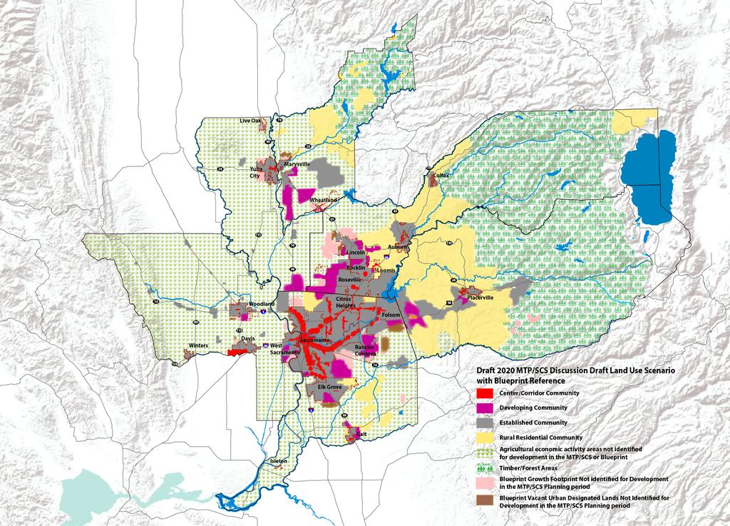
2 4. Discussion/Analysis: There are three foundation elements of the Discussion Scenario: 1) Land Use Forecast The land use assumptions of the Discussion Scenario were shared and discussed with the board in June and are provided again in Attachment A for reference. In May and June, a few jurisdictions and board members raised concerns about the growth assumptions in the Discussion Scenario for their specific community. OG has been following up with local agency staff to further discuss these concerns. In addition, staff is continuing to engage all member agency staff and stakeholders to collect more information that will help inform the final land use forecast for the plan update. Specifically, we are continuing to research and analyze the various hurdles to infill development, as well as potential solutions. Staff has also sent a survey to member agencies focused on collecting detailed information on the greenfield areas throughout the region. 2) Transportation Investments Since June, staff has worked to pair a package of transportation investments, based on local input and OG s own performance analysis, with the discussion draft land uses to create a complete Discussion Scenario for 2035 and The transportation investments of the Discussion Scenario are included as Attachment B. The process that staff used to select projects for inclusion in the scenario mirrors the process we used in the 2016 MTP/SCS. This process begins with the full list of transportation projects nominated by local agency staff, then uses project screening criteria to evaluate the timing, or the phasing, of projects. This methodology is described in Attachment C. The screening questions allow OG staff to refine an initial set of transportation projects that can be used to model the Discussion Scenario. Refining which transportation projects are ultimately included in the draft plan is an iterative process that will go through spring of next year. The Discussion Draft transportation project list is the beginning of this process. OG sent the attached Discussion Scenario transportation project list to member agencies last week. This began an initial one month vetting period during which time local agencies are asked to review the project list and provide comment. OG staff are available to meet with local agency staff to discuss the Discussion Scenario, the screening criteria, and any questions or concerns local agency staff may have. These meetings will continue through this fall on an as requested basis. For the jurisdictions in El Dorado and Placer Counties, the project list review will be coordinated by the Transportation Commission and Placer Transportation Planning Agency. 3) Performance Outcomes A partial summary of the land use and transportation inputs and the performance measures for the Discussion Scenario is included in Attachment D. Staff will provide a more complete summary at the committee meeting, and will spend more time next month on a performance outcomes briefing and how it affects board policy choices for this plan update. The inputs and performance outcomes described in the attachment are intended to give the board information needed to understand the implications and tradeoffs of various policy
3 decisions facing the MTP/SCS. Specifically, the attachment serves as a snapshot of how the land use and transportation assumptions included in the Discussion Scenario affect the plan s ability to meet performance objectives such as state greenhouse gas reduction targets, mode shares, congestion relief, transit productivity, natural resource consumption, and access to jobs and services. The board can use this information to provide direction to staff on major policy elements of the plan, such as the allocation of housing and jobs, strategies for managing the transportation system, and how to prioritize investments among different budget categories, including transit, road, and highway capacity, active transportation, and system maintenance and preservation. In December, staff anticipates requesting action on a framework reflecting the board's major policy interests in the final scenario. Attachment E describes the information coming to the board over the next few months in anticipation of that action. 5. Fiscal Impact/Grant Information: There is no anticipated fiscal impact to OG s operating budget beyond the staff and consulting resources already included in the board adopted agency budget for Fiscal Year This staff report aligns with the following OG Work Plan Goals: 1. Advance Economic Prosperity ATTACHMENTS: Descrip on A achment A - Discussion Dra Land Use Forecast A achment B - Discussion Dra Project List A achment C - Screening Ques ons A achment D - Discussion Dra Performance Indicators A achment E - Board Calendar
4 Draft as of August 1, 2018 All estimates are rounded; subtotals may not sum exactly due to rounding. Attachment A 2020 Metropolitan Transportation Plan/Sustainable Communities Strategy Update Existing Conditions 2020 MTP/SCS Discussion Draft TOTAL 2020 MTP/SCS Discussion Draft TOTAL 2016 MTP/SCS (this is for reference only) Build Out Estimate 2020 MTP/SCS Discussion Draft GROWTH 2020 MTP/SCS Discussion Draft GROWTH Discussion Draft Land Use Scenario Estimates for 2035 and 2040 Total in Year 2016 Total in Year 2035 Total in Year 2040 Total in Year 2036 Total at Build Out Jurisdiction/Community Type Jobs Units Jobs Units Jobs Units Jobs Units Jobs Units Growth from 2016 to 2035 Jobs Units Growth from 2016 to 2040 Jobs Units Placerville Center and Corridor Communites 4, , , , , Established Communitites 5,250 4,360 5,650 4,830 5,760 5,010 7,300 5,220 7,100 5, Jurisdiction Total 9,520 4,540 10,050 5,040 10,190 5,240 11,550 5,460 12,030 5, Unincorporated Center and Corridor Communities (listed below) El Dorado Hills Town Center 3,050-3, , , , Pleasant Valley Rd (between Missouri Flat Rd and Hwy 99) Established Communities 22,110 29,600 27,810 31,940 29,110 32,300 32,600 34,680 49,390 51,530 5,700 2,330 7,000 2,700 Rural Residential Communities (includes agricultural areas) 8,020 23,420 8,070 24,070 8,120 24,220 9,640 26,140 13,930 28, Developing Communities (listed below) Bass Lake Hills , , , ,000 Carson Creek , , ,160 3,880 1, El Dorado Hills (including Serrano) 2,120 3,690 2,370 4,480 2,470 4,690 2,030 4,560 3,370 6, ,000 Marble Valley Missouri Flat (El Dorado Rd to Pleasant Valley Rd) 3, , , , , Valley View 150 1, , , , ,840-1,450-1,450 Projects Not Identified for Growth in the 2020 MTP/SCS Discussion Draft by 2040 (listed below) Lime Rock Valley Jurisdiction Total 39,360 59,250 46,420 66,610 48,100 67,560 52,490 70,340 81,860 94,930 7,050 7,360 8,740 8,310 EL DORADO COUNTY TOTAL 48,880 63,790 56,470 71,660 58,290 72,800 64,040 75,800 93, ,620 7,590 7,860 9,420 9,010 1The Build Out Estimate shown reflects adopted planning documents. However, the county is processing an application for this area that could result in a change to these estimates. 1
5 Draft as of August 1, 2018 All estimates are rounded; subtotals may not sum exactly due to rounding. Attachment A 2020 Metropolitan Transportation Plan/Sustainable Communities Strategy Update Existing Conditions 2020 MTP/SCS Discussion Draft TOTAL 2020 MTP/SCS Discussion Draft TOTAL 2016 MTP/SCS (this is for reference only) Build Out Estimate 2020 MTP/SCS Discussion Draft GROWTH 2020 MTP/SCS Discussion Draft GROWTH Discussion Draft Land Use Scenario Estimates for 2035 and 2040 Total in Year 2016 Total in Year 2035 Total in Year 2040 Total in Year 2036 Total at Build Out Jurisdiction/Community Type Jobs Units Jobs Units Jobs Units Jobs Units Jobs Units Auburn Growth from 2016 to 2035 Jobs Units Growth from 2016 to 2040 Jobs Units Center and Corridor Communities (Amtrak station and Hwy 49) 2, , , , , Established Communities 6,600 5,660 7,260 5,990 7,420 6,060 6,890 5,910 9,110 7, Projects Not Identified for Growth in the 2020 MTP/SCS by 2040 (listed below) Baltimore Ravine Jurisdiction Total 9,580 6,150 10,580 6,690 10,800 6,810 10,060 7,390 13,150 8, , Colfax Center and Corridor Communities (I-80 Corridor area) , , , , Established Communities , Jurisdiction Total ,170 1,080 1,280 1,120 1,500 1,020 3,280 1, Lincoln Center and Corridor Communities 4, ,600 1,050 6,000 1,050 6,250 1,040 8,850 1,120 1, , Established Communities 5,630 18,290 8,640 21,650 8,640 21,650 6,470 20,570 17,680 21,650 3,000 3,360 3,000 3,360 Developing Communities (listed below) Hwy 65 area 1,940-4,540-5,140-5,460-11,010-2,600-3,200 - Village , , , , , ,800 Village , , , , , ,400 Projects Not Identified for Growth in the 2020 MTP/SCS Discussion Draft by 2040 (listed below) Village , Village unknown 4, Village unknown 5, Village 5/SUD B ,150 11,400 8, Village unknown 5, SUD A unknown 2, SUD C unknown Jurisdiction Total 11,840 18,830 19,200 25,690 20,470 28,150 19,350 29,090 50,360 61,360 7,360 6,860 8,640 9,310 Loomis Center and Corridor Communities (Town Center area) , Established Communities 2,730 1,470 3,130 1,620 3,230 1,620 3,250 1,750 4,040 1, Rural Residential Communities , Jurisdiction Total 3,620 2,480 4,350 3,090 4,540 3,120 4,910 3,250 6,110 3,
6 Draft as of August 1, 2018 All estimates are rounded; subtotals may not sum exactly due to rounding. Attachment A 2020 Metropolitan Transportation Plan/Sustainable Communities Strategy Update Existing Conditions 2020 MTP/SCS Discussion Draft TOTAL 2020 MTP/SCS Discussion Draft TOTAL 2016 MTP/SCS (this is for reference only) Build Out Estimate 2020 MTP/SCS Discussion Draft GROWTH 2020 MTP/SCS Discussion Draft GROWTH Discussion Draft Land Use Scenario Estimates for 2035 and 2040 Total in Year 2016 Total in Year 2035 Total in Year 2040 Total in Year 2036 Total at Build Out Jurisdiction/Community Type Jobs Units Jobs Units Jobs Units Jobs Units Jobs Units Growth from 2016 to 2035 Jobs Units Growth from 2016 to 2040 Jobs Units Rocklin Center and Corridor Communities (Rocklin Downtown Plan area and Amtrak station area) 1,310 1,000 1,710 1,310 1,810 1,500 1,320 1,320 1,900 1, Established Communities 17,250 20,050 19,850 24,230 20,150 24,230 19,320 22,880 24,000 24,240 2,600 4,180 2,900 4,180 Developing Communities (listed below) Highway 65 Corridor , ,690 1,040 4, ,000 1,230 2, ,500 1,000 I-80 Commercial 1,400-2, , , , , , Sunset Ranchos 430 1, , ,250 1,240 4,360 1,200 4, , ,510 Clover Valley Jurisdiction Total 20,580 22,840 27,680 31,030 28,780 31,420 28,440 29,270 34,600 32,480 7,100 8,190 8,200 8,580 Roseville Center and Corridor Communities (Amtrak station area and Douglas/Sunrise) Dowtown Master Plan and remaining Amtrak station 2,550 1,550 3,490 2,150 3,750 2,350 3,790 2,310 10,790 2, , Douglas West 1, , , , , Sunrise 2, , , , , Established Communities 75,350 44,910 90,360 48,710 93,350 49,730 82,120 47, ,800 49,730 15,000 3,800 18,000 4,810 Developing Communities (listed below) Creekview , , , , , ,010 Sierra Vista ,500 4,800 2,000 6,090 3,500 6,120 7,500 8,660 1,500 4,800 2,000 6,090 West Roseville 670 4,380 3,140 10,500 3,170 10,500 2,980 9,430 3,250 10,500 2,470 6,120 2,500 6,120 Amoruso Ranch , ,000 1,460 2, ,750 Jurisdiction Total 82,370 51, ,040 68, ,180 73,330 98,270 68, ,640 76,900 20,670 17,460 24,810 21,840 3
7 Draft as of August 1, 2018 All estimates are rounded; subtotals may not sum exactly due to rounding. Attachment A 2020 Metropolitan Transportation Plan/Sustainable Communities Strategy Update Existing Conditions 2020 MTP/SCS Discussion Draft TOTAL 2020 MTP/SCS Discussion Draft TOTAL 2016 MTP/SCS (this is for reference only) Build Out Estimate 2020 MTP/SCS Discussion Draft GROWTH 2020 MTP/SCS Discussion Draft GROWTH Discussion Draft Land Use Scenario Estimates for 2035 and 2040 Total in Year 2016 Total in Year 2035 Total in Year 2040 Total in Year 2036 Total at Build Out Jurisdiction/Community Type Jobs Units Jobs Units Jobs Units Jobs Units Jobs Units Growth from 2016 to 2035 Jobs Units Growth from 2016 to 2040 Jobs Units Placer Unincorporated Established Communities 25,440 17,440 38,440 19,640 41,440 20,040 34,780 17,750 71,740 26,260 13,000 2,200 16,000 2,600 Rural Residential Communities (includes agricultural areas) 8,350 26,360 8,640 27,620 8,750 28,370 8,330 29,420 27,200 50, , ,000 Developing Communities (listed below) Bickford Ranch , , , , , ,880 Placer Vineyards , ,870 1,500 4,740 6,000 14, , ,700 Regional University , , ,450 1,400 3, , ,450 Riolo Vineyards Placer Ranch ,000 2,000 2,900 20,160 5, ,000 Squaw Village Projects Not Identified for Growth in the 2020 MTP/SCS Discussion Draft by 2040 (listed below) Curry Creek unknown unknown Jurisdiction Total 33,860 43,990 48,420 55,130 52,020 57,900 47,520 58, , ,190 14,560 11,140 18,160 13,920 CER COUNTY TOTAL 162, , , , , , , , , ,170 51,860 44,960 62,500 55,150 4
8 Draft as of August 1, 2018 All estimates are rounded; subtotals may not sum exactly due to rounding. Attachment A 2020 Metropolitan Transportation Plan/Sustainable Communities Strategy Update Existing Conditions 2020 MTP/SCS Discussion Draft TOTAL 2020 MTP/SCS Discussion Draft TOTAL 2016 MTP/SCS (this is for reference only) Build Out Estimate 2020 MTP/SCS Discussion Draft GROWTH 2020 MTP/SCS Discussion Draft GROWTH Discussion Draft Land Use Scenario Estimates for 2035 and 2040 Total in Year 2016 Total in Year 2035 Total in Year 2040 Total in Year 2036 Total at Build Out Jurisdiction/Community Type Jobs Units Jobs Units Jobs Units Jobs Units Jobs Units Citrus Heights Center and Corridor Communities (listed below) Growth from 2016 to 2035 Jobs Units Growth from 2016 to 2040 Jobs Units Sunrise Blvd 4,620 1,020 5,820 1,330 6,120 1,630 7,230 1,840 7,230 2,070 1, , Riverside-Auburn (Boulevard Plan) 2, , ,050 1,030 3, ,910 2, Established Communities 13,330 33,830 14,330 34,380 14,740 34,540 13,460 35,300 14,740 36,550 1, , Jurisdiction Total 20,500 35,580 23,100 36,630 23,900 37,190 23,810 38,060 26,880 40,650 2,600 1,040 3,400 1,610 Elk Grove Center and Corridor Communities (Old Town Plan area) 1, , , , Established Communities 40,630 49,380 44,340 51,880 45,140 52,460 36,470 48,960 47,030 56,240 3,700 2,500 4,500 3,080 Rural Residential Communities 830 1, , , ,390 2,910 3, Developing Communities (listed below) Laguna Ridge 1,600 2,940 4,300 6,780 4,600 6,780 4,370 7,590 7,650 6,770 2,700 3,840 3,000 3,840 Lent Ranch 170-2, , , , , , Southeast Planning Area ,210 3,830 4,000 4,030 5,000 4,060 18,640 4,040 3,200 3,800 3,990 4,000 Sterling Meadows ,180-1, ,180-1,180-1,180 Projects Not Identified for Growth in the 2020 MTP/SCS Discussion Draft by 2040 (listed below) East Study Area ,880 4, South Study Area ,370 16, North Study Area West Study Area ,130 9, Jurisdiction Total 44,320 53,720 56,550 65,680 59,070 66,600 50,860 65, , ,870 12,230 11,960 14,760 12,880 Folsom Center and Corridor Communities (light rail station areas and Bidwell) 9,160 1,440 10,460 2,030 10,760 2,140 9,850 2,010 9,850 2,190 1, , Established Communities 36,270 26,110 38,470 28,910 38,970 29,180 32,490 28,170 41,320 29,180 2,200 2,800 2,700 3,070 Developing Communities (listed below) Folsom South Area - - 1,300 5,800 2,000 7,000 7,190 8,670 13,620 11,340 1,300 5,800 2,000 7,000 Jurisdiction Total 45,430 27,550 50,230 36,740 51,730 38,320 49,540 38,850 64,790 42,700 4,800 9,190 6,300 10,770 Galt Center and Corridor Communities (downtown and Twin Cities) 1, , , , , Established Communities 3,050 7,480 4,850 9,330 5,050 9,330 4,960 9,200 9,230 9,330 1,810 1,850 2,000 1,850 Developing Communities (listed below) Eastview and SOI , , ,090 24,180 7, ,000 Jurisdiction Total 5,330 8,170 8,090 10,960 8,440 11,160 8,170 10,890 36,710 17,060 2,760 2,790 3,110 2,990 5
9 Draft as of August 1, 2018 All estimates are rounded; subtotals may not sum exactly due to rounding. Attachment A 2020 Metropolitan Transportation Plan/Sustainable Communities Strategy Update Existing Conditions 2020 MTP/SCS Discussion Draft TOTAL 2020 MTP/SCS Discussion Draft TOTAL 2016 MTP/SCS (this is for reference only) Build Out Estimate 2020 MTP/SCS Discussion Draft GROWTH 2020 MTP/SCS Discussion Draft GROWTH Discussion Draft Land Use Scenario Estimates for 2035 and 2040 Total in Year 2016 Total in Year 2035 Total in Year 2040 Total in Year 2036 Total at Build Out Jurisdiction/Community Type Jobs Units Jobs Units Jobs Units Jobs Units Jobs Units Growth from 2016 to 2035 Jobs Units Growth from 2016 to 2040 Jobs Units Isleton Established Communities Developing Communities (listed below) Villages on the Delta Jurisdiction Total Rancho Center and Corridor Communities (Folsom Blvd Corridor Plan area and light rail station areas) 16,540 6,270 19,140 7,470 19,830 7,930 22,010 8,180 40,760 7,930 2,600 1,200 3,300 1,660 Established Communities 42,270 16,850 53,070 17,920 55,270 17,920 54,340 18,040 66,880 17,910 10,800 1,070 13,000 1,070 Developing Communities (listed below) Ranch at Sunridge , Rio Del Oro - - 1,200 4,300 1,500 5,000 2,090 5,120 15,090 12,190 1,200 4,300 1,500 5,000 Suncreek , , ,390 2,380 4,890-2, ,400 Sunridge 600 3,740 1,800 8,040 2,090 8,040 2,170 7,710 2,550 8,040 1,200 4,300 1,500 4,300 Projects Not Identified for Growth in the 2020 MTP/SCS Discussion Draft by 2040 (listed below) Arboretum ,530 3,490 4, Westborough ,450 7, Jurisdiction Total 59,410 26,860 75,200 40,720 78,900 42,980 81,200 45, ,910 64,400 15,800 13,860 19,500 16,120 6
10 Draft as of August 1, 2018 All estimates are rounded; subtotals may not sum exactly due to rounding. Attachment A 2020 Metropolitan Transportation Plan/Sustainable Communities Strategy Update Existing Conditions 2020 MTP/SCS Discussion Draft TOTAL 2020 MTP/SCS Discussion Draft TOTAL 2016 MTP/SCS (this is for reference only) Build Out Estimate 2020 MTP/SCS Discussion Draft GROWTH 2020 MTP/SCS Discussion Draft GROWTH Discussion Draft Land Use Scenario Estimates for 2035 and 2040 Total in Year 2016 Total in Year 2035 Total in Year 2040 Total in Year 2036 Total at Build Out Jurisdiction/Community Type Jobs Units Jobs Units Jobs Units Jobs Units Jobs Units Growth from 2016 to 2035 Jobs Units Growth from 2016 to 2040 Jobs Units Center and Corridor Communities (listed below) Blue Line Station Areas- American River to Swanston 8,970 3,100 10,790 3,810 11,270 4,110 11,520 4,090 14,550 6,050 1, ,300 1,000 Blue Line Station Areas- Marconi 980 1,280 1,130 1,810 1,130 1,890 1,650 1,890 1,360 1, Blue Line Station Areas- Roseville Rd/Watt 1, , , , Green Line Station Areas- South Natomas 2,860 6,700 3,600 6,830 3,600 6,830 3,730 6,820 3,610 6, Green Line Station Areas- North Natomas Marketplace 7,120 2,280 7,830 3,690 7,970 4,180 9,280 3,330 14,920 6, , ,900 Green Line Station Areas- Commerce Pkwy 1,900 1,670 3,040 3,980 3,330 4,750 3,330 4,750 3,440 4,760 1,130 2,310 1,430 3,080 Green Line Station Areas- Greenbriar , , ,430 1,140 4, , ,430 Downtown (East of 16th St) 38,130 12,920 41,320 16,120 42,130 16,920 31,310 16,230 42,000 16,400 3,200 3,200 4,000 4,000 Downtown (West of 16th St) 86,940 9, ,950 28, ,950 30, ,880 27, ,370 31,540 16,000 19,000 17,000 21,000 Franklin Blvd 2,630 1,840 2,940 2,220 2,940 2,220 2,940 2,220 3,040 2, Gold Line Station Areas- 39th to 59th 10,530 3,790 10,530 4,190 10,610 4,190 8,370 3,850 10,540 3, Gold Line Station Areas- 65th to Power Inn 9,550 2,160 11,760 7,540 12,270 7,570 12,990 7,600 14,040 7,900 2,200 5,380 2,720 5,420 Gold Line Station Areas- College Greens and part of watt 1,960 1,220 2,120 1,390 2,120 1,390 2,860 1,400 4,870 2, Blue Line Station Areas- Broadway to 47th 7,810 5,410 9,010 6,140 9,010 6,140 8,170 6,140 9,930 6,220 1, , Blue Line Station Areas- Florin 2,340 1,400 2,790 2,600 2,790 2,600 3,740 2,660 3,700 2, , ,200 Blue Line Station Areas- Meadowview to CRC 3,510 6,780 3,800 10,280 3,800 10,280 3,180 9,800 4,000 10, , ,500 Blue Line Station Areas- 14th Ave to Florin Rd 2,550 1,950 2,590 2,710 2,600 3,180 3,370 3,090 3,330 3, ,240 Established Communities 119, , , , , , , , , ,140 17,000 18,000 21,000 20,000 Developing Communities (listed below) Delta Shores - - 2,500 5,010 3,000 5,010 2,220 5,080 6,660 5,120 2,500 5,010 3,000 5,010 Projects Not Identified for Growth in the 2020 MTP/SCS Discussion Draft by 2040 (listed below) Panhandle , Jurisdiction Total 308, , , , , , , , , ,530 48,310 65,240 56,130 72,200 7
11 Draft as of August 1, 2018 All estimates are rounded; subtotals may not sum exactly due to rounding. Attachment A 2020 Metropolitan Transportation Plan/Sustainable Communities Strategy Update Existing Conditions 2020 MTP/SCS Discussion Draft TOTAL 2020 MTP/SCS Discussion Draft TOTAL 2016 MTP/SCS (this is for reference only) Build Out Estimate 2020 MTP/SCS Discussion Draft GROWTH 2020 MTP/SCS Discussion Draft GROWTH Discussion Draft Land Use Scenario Estimates for 2035 and 2040 Total in Year 2016 Total in Year 2035 Total in Year 2040 Total in Year 2036 Total at Build Out Jurisdiction/Community Type Jobs Units Jobs Units Jobs Units Jobs Units Jobs Units Growth from 2016 to 2035 Jobs Units Growth from 2016 to 2040 Jobs Units Unincorporated Center and Corridor Communities (listed below) Auburn Blvd North/Madison Ave 8, , ,800 1,090 9,800 1,090 11,940 1,300 1, , Blue Line Station Areas- Roseville Rd/Watt 3, , , , ,210 2, Fair Oaks Blvd West- Howe to Fulton 6,230 2,800 6,610 2,930 6,710 2,930 6,710 2,930 6,890 2, Fair Oaks Blvd Central- El Camino to Winding 6,120 3,700 7,070 4,400 7,320 4,560 7,820 4,560 10,290 5, , Fair Oaks Blvd East- Fair Oaks Village 2,320 1,050 2,800 1,290 2,920 1,290 2,730 1,290 3,000 1, Florin Rd 8,080 1,530 8,830 2,420 9,030 2,700 8,400 2,710 12,490 6, ,180 Franklin Blvd 2,590 2,210 3,800 3,100 4,090 3,360 5,010 3,360 5,680 3,790 1, ,500 1,150 Fulton Ave 6, , , , ,880 1, , Gold Line Station Areas- Watt to Butterfield 12,020 4,990 14,820 7,590 15,490 8,000 15,490 9,570 16,960 8,000 2,800 2,600 3,470 3,010 Gold Line Station Areas- Hazel/Easton 1, ,760 2,590 4,270 2,790 5,860 2,120 19,410 2,800 2,300 2,010 2,800 2,220 Gold Line Station Areas- Folsom Blvd , Greenback Ln 4,050 2,060 4,340 2,260 4,500 2,400 4,500 2,400 4,640 2, Stockton Blvd- 14th Ave to Florin Rd , , , , Stockton Blvd- Florin Rd to Mack Rd 3,570 2,940 4,370 3,840 4,670 4,530 4,900 4,240 5,630 5, ,100 1,600 Watt Ave Central- Auburn to Arden 9,460 2,470 12,460 2,920 13,280 3,200 13,280 3,200 13,420 3,200 3, , North Watt and West of Watt 4,870 1,390 6,570 4,090 6,970 4,990 7,620 4,970 12,230 7,000 1,700 2,700 2,100 3,600 Established Communities 111, , , , , , , , , ,160 18,000 6,500 24,000 7,500 Rural Residential Communities (includes agricultural areas) 8,380 13,390 8,580 13,500 8,680 13,540 12,460 14,310 15,540 18, Developing Communities (listed below) Elverta , , , , , ,700 Florin Vineyard 1, , ,530 1,040 1,530 2,580 6,240 9, Glenborough at Easton , ,240 1,780 3,270 1,800 3, , ,240 North Vineyard Station , , , , , ,400 Mather South , , ,030 5,080 3,530-1, ,810 Vineyard Springs 650 2, , , , , Vineyard 1,760 4,670 1,760 5,070 1,760 5,150 1,550 5,350 1,800 6, Projects Not Identified for Growth in the 2020 MTP/SCS Discussion Draft by 2040 (listed below) Hills ,560 8, West Jackson 1, , , ,030 5,140 32,840 14, Jackson Township ,040 6, Newbridge ,560 3, Natomas North Precinct ,350 23, Jurisdiction Total 204, , , , , , , , , ,830 36,730 29,880 48,110 36,050 RAMENTO COUNTY TOTAL 688, , , , , , , ,360 1,292, , , , , ,690 8
12 Draft as of August 1, 2018 All estimates are rounded; subtotals may not sum exactly due to rounding. Attachment A 2020 Metropolitan Transportation Plan/Sustainable Communities Strategy Update Existing Conditions 2020 MTP/SCS Discussion Draft TOTAL 2020 MTP/SCS Discussion Draft TOTAL 2016 MTP/SCS (this is for reference only) Build Out Estimate 2020 MTP/SCS Discussion Draft GROWTH 2020 MTP/SCS Discussion Draft GROWTH Discussion Draft Land Use Scenario Estimates for 2035 and 2040 Total in Year 2016 Total in Year 2035 Total in Year 2040 Total in Year 2036 Total at Build Out Jurisdiction/Community Type Jobs Units Jobs Units Jobs Units Jobs Units Jobs Units Growth from 2016 to 2035 Jobs Units Growth from 2016 to 2040 Jobs Units Live Oak Center and Corridor Communities (downtown area) , Established Communities 700 2, ,040 1,000 3,430 1,050 3,680 2,450 4, Projects Not Identified for Growth in the 2020 MTP/SCS Discussion Draft by 2040 (listed below) Recent annexation areas ,590 2, Sphere of Influence Area ,300 10, Jurisdiction Total 1,270 2,890 1,770 3,490 1,870 3,890 1,910 3,770 14,310 18, ,000 Yuba City Center and Corridor Communities (Central City and Hwy 20 corridor) 7,790 1,990 8,990 2,080 9,390 2,080 9,990 1,910 10,040 2,080 1, , Established Communities 19,590 23,240 23,690 27,440 24,700 28,040 24,060 28,060 29,210 28,050 4,100 4,200 5,110 4,800 Developing Communities (listed below) South SOI/Hwy 99 Corridor ,800 2, Projects Not Identified for Growth in the 2020 MTP/SCS Discussion Draft by 2040 (listed below) Lincoln East (SOI) ,570 4, Remainder Sphere of Influence area ,490 5, Jurisdiction Total 27,920 26,070 33,420 30,550 34,830 31,160 34,800 31,170 46,110 42,570 5,500 4,490 6,910 5,090 Sutter Unincorporated Established Communities (includes agricultural areas) 4,110 5,190 4,190 5,440 4,210 5,490 4,100 6,840 13,790 7, Developing Communities (listed below) Sutter Pointe 840-1, ,840 1,500 3,000 3,030 55,040 17, ,000 1,500 Projects Not Identified for Growth in the 2020 MTP/SCS Discussion Draft by 2040 (listed below) Employment Centers , Jurisdiction Total 5,230 5,240 5,910 6,290 6,340 7,040 7,090 9,870 83,060 24, ,050 1,100 1,800 SUTTER COUNTY TOTAL 34,420 34,200 41,090 40,330 43,030 42,090 43,800 44, ,480 85,720 6,670 6,140 8,610 7,890 9
13 Draft as of August 1, 2018 All estimates are rounded; subtotals may not sum exactly due to rounding. Attachment A 2020 Metropolitan Transportation Plan/Sustainable Communities Strategy Update Existing Conditions 2020 MTP/SCS Discussion Draft TOTAL 2020 MTP/SCS Discussion Draft TOTAL 2016 MTP/SCS (this is for reference only) Build Out Estimate 2020 MTP/SCS Discussion Draft GROWTH 2020 MTP/SCS Discussion Draft GROWTH Discussion Draft Land Use Scenario Estimates for 2035 and 2040 Total in Year 2016 Total in Year 2035 Total in Year 2040 Total in Year 2036 Total at Build Out Jurisdiction/Community Type Jobs Units Jobs Units Jobs Units Jobs Units Jobs Units Davis Center and Corridor Communities (listed below) Growth from 2016 to 2035 Jobs Units Growth from 2016 to 2040 Jobs Units Core Area 6,490 1,830 7,000 2,480 7,120 2,630 6,190 2,250 4, Nishi (subject to voter approval) , Established Communities 17,270 25,020 18,070 26,670 18,270 27,320 13,740 26,480 18,000 27, ,650 1,000 2,300 Jurisdiction Total 23,760 26,850 25,070 29,850 25,390 30,660 20,340 29,330 24,000 28,800 1,310 3,000 1,620 3,810 West Center and Corridor Communities (listed below) Bridge District ,720 4,090 4,520 4,390 7,570 4,570 13,720 4,570 3,200 3,700 4,000 4,000 Pioneer Bluff 980-1,580 1,010 2,590 1,700 3,390 1,680 7,500 3, ,010 1,600 1,700 Washington 2,980 1,150 3,880 2,950 4,080 3,150 4,430 3,090 5,690 3, ,800 1,100 2,000 remaining center and corridor area 1,990 1,020 2,340 1,720 2,490 2,020 3,350 3,970 21,290 7, ,000 Established Communities 25,020 16,820 29,810 20,620 31,010 20,620 31,520 20,660 38,440 20,640 4,800 3,800 6,000 3,800 Developing Communities (listed below) Liberty , , , , ,500 Southport Industrial Park 1, , , , ,010 1,380 2, , Yarborough , , , , ,800 Projects Not Identified for Growth in the 2020 MTP/SCS Discussion Draft by 2040 (listed below) River Park , Jurisdiction Total 33,120 19,730 45,770 33,830 49,820 35,730 55,360 34,930 91,710 48,000 12,650 14,100 16,690 16,000 Winters Center and Corridor Communities (Downtown Master Plan area) Established Communities 2,180 2,350 2,790 3,150 2,940 3,310 2,940 3,300 4,940 4, Projects Not Identified for Growth in the 2020 MTP/SCS Discussion Draft by 2040 (listed below) Sphere of Influence Area unknown unknown Jurisdiction Total 2,280 2,400 2,990 3,200 3,160 3,370 3,120 3,340 5,140 4, Woodland Center and Corridor Communities (Downtown and East St Corridor Plan areas) 3, ,870 2,020 3,910 2,040 3,390 1,350 4,740 2, , ,320 Established Communities 21,140 18,150 26,540 18,780 27,840 18,780 28,400 18,780 43,140 18,780 5, , Developing Communities (listed below) Spring Lake Master Plan 1,400 1,640 1,600 4,180 1,600 4,180 1,240 4,050 1,600 4, , ,540 Woodland Research and Technology Park , ,200 1, , Projects Not Identified for Growth in the 2020 MTP/SCS Discussion Draft by 2040 (listed below) New Growth Area SP-1 (minus research and technology park) unknown 2, New Growth Area SP unknown 1, New Growth Area SP unknown Jurisdiction Total 26,160 20,520 32,820 24,990 34,370 25,210 33,030 24,180 55,690 30,650 6,660 4,470 8,210 4,700 Yolo Unincorporated Center and Corridor Communities (UC Davis) 12,580 1,530 14,710 4,140 15,070 4,230 24,210 3,380 15,080 4,230 2,130 2,600 2,500 2,700 Established Communities (includes agricultural areas) 6,850 6,680 7,500 6,760 7,650 6,780 9,680 7,600 12,500 8, Jurisdiction Total 19,430 8,210 22,210 10,890 22,720 11,010 33,890 10,990 27,580 12,450 2,780 2,680 3,300 2,800 10
14 Draft as of August 1, 2018 All estimates are rounded; subtotals may not sum exactly due to rounding. Attachment A 2020 Metropolitan Transportation Plan/Sustainable Communities Strategy Update Existing Conditions 2020 MTP/SCS Discussion Draft TOTAL 2020 MTP/SCS Discussion Draft TOTAL 2016 MTP/SCS (this is for reference only) Build Out Estimate 2020 MTP/SCS Discussion Draft GROWTH 2020 MTP/SCS Discussion Draft GROWTH Growth from 2016 to Growth from 2016 to Discussion Draft Land Use Scenario Estimates for 2035 and 2040 Total in Year 2016 Total in Year 2035 Total in Year 2040 Total in Year 2036 Total at Build Out Jurisdiction/Community Type Jobs Units Jobs Units Jobs Units Jobs Units Jobs Units Jobs Units Jobs Units YOLO COUNTY TOTAL 104,750 77, , , , , , , , ,220 24,110 25,050 30,700 28,260 11
15 Draft as of August 1, 2018 All estimates are rounded; subtotals may not sum exactly due to rounding. Attachment A 2020 Metropolitan Transportation Plan/Sustainable Communities Strategy Update Existing Conditions 2020 MTP/SCS Discussion Draft TOTAL 2020 MTP/SCS Discussion Draft TOTAL 2016 MTP/SCS (this is for reference only) Build Out Estimate 2020 MTP/SCS Discussion Draft GROWTH 2020 MTP/SCS Discussion Draft GROWTH Discussion Draft Land Use Scenario Estimates for 2035 and 2040 Total in Year 2016 Total in Year 2035 Total in Year 2040 Total in Year 2036 Total at Build Out Jurisdiction/Community Type Jobs Units Jobs Units Jobs Units Jobs Units Jobs Units Growth from 2016 to 2035 Jobs Units Growth from 2016 to 2040 Jobs Units Marysville Center and Corridor Communities (Downtown Economic Development Strategic Plan area) 3, , , , , Established Communities 4,610 5,060 4,980 5,280 5,070 5,280 6,290 5,290 6,200 5, Jurisdiction Total 7,750 5,450 8,270 5,690 8,410 5,690 9,590 5,710 9,540 5, Wheatland Center and Corridor Communities (dowtown area) Established Communities 730 1, , , , , Developing Communities (listed below) Jones Ranch and Heritage Oaks ,290 1, Projects Not Identified for Growth in the 2020 MTP/SCS Discussion Draft by 2040 (listed below) Nichols Grove , Hop Farm/Johnson Rancho ,860 14, Rodden Ranch Jurisdiction Total 810 1,420 1,260 2,140 1,410 2,510 1,460 2,420 10,230 19, ,090 Yuba Unincorporated Center and Corridor Communities (listed below) North Beale Corridor Reinvestmant Plan area , , Olivehurst Ave Established Communities 3,420 6,960 4,070 7,380 4,220 7,460 4,640 8,140 6,060 10, Established Communities-Beale AFB 3, , , , ,550 1,000 1, , Developing Communities (listed below) East Linda 290 2, ,110 1,090 4,410 1,560 4,440 4,430 6, , ,000 North Arboga Study Area 280 1, , , ,420 2,560 2, Plumas Lake 700 2,730 1,400 4,280 2,100 4,530 2,560 4,890 16,180 18, ,550 1,400 1,800 Highway 65 Employment Center , , , , ,500 - Rural Residential Communities (includes agricultural areas) 3,220 7,040 3,220 7,120 3,230 7,140 3,380 7,880 5,090 12, Jurisdiction Total 12,850 21,510 16,720 25,690 19,040 26,390 21,450 27,860 65,330 51,750 3,870 4,180 6,190 4,880 YUBA COUNTY TOTAL 21,410 28,380 26,240 33,520 28,860 34,580 32,500 36,000 85,090 77,230 4,830 5,140 7,450 6,210 12
16 Draft as of August 1, 2018 All estimates are rounded; subtotals may not sum exactly due to rounding. Attachment A 2020 Metropolitan Transportation Plan/Sustainable Communities Strategy Update Existing Conditions 2020 MTP/SCS Discussion Draft TOTAL 2020 MTP/SCS Discussion Draft TOTAL 2016 MTP/SCS (this is for reference only) Build Out Estimate 2020 MTP/SCS Discussion Draft GROWTH 2020 MTP/SCS Discussion Draft GROWTH Discussion Draft Land Use Scenario Estimates for 2035 and 2040 Total in Year 2016 Total in Year 2035 Total in Year 2040 Total in Year 2036 Total at Build Out Jurisdiction/Community Type Jobs Units Jobs Units Jobs Units Jobs Units Jobs Units Growth from 2016 to 2035 Jobs Units Growth from 2016 to 2040 Jobs Units Region Total 1,060, ,140 1,278,820 1,144,300 1,330,530 1,180,340 1,327,280 1,187,870 2,194,050 1,583, , , , ,200 Center and Corridor Communities 368, , , , , , , , , ,730 68,160 73,360 82,050 85,320 Established Communities 636, , , , , , , ,050 1,052, , ,180 63, ,620 71,360 Developing Communities 23,260 36,540 58, ,750 69, ,540 83, , , ,200 35,300 84,210 46,350 99,000 Rural Residential Communities 29,210 72,280 29,860 74,680 30,180 75,810 35,510 82,080 65, , , ,530 Projects Not Identified for Growth in the 2020 MTP/SCS Discussion Draft by ,680 1,970 2,680 1,970 2,680 1,970 5,220 11, , ,
17
18 A- Bike & Ped SR 49 - Construct Class II Bike Lane On SR 49, from Southview Ct. in Placerville (south of US 50) to Gold Hill Rd (Approximately 5 miles north of US 50), where feasible Construct Class II Bike Lane $2,880,000 A- Bike & Ped Widen shoulders to 8ft to provide ped/bike access along hwy In ED on Route 49 from Patterson Dr to Missouri Flat Rd $900,000 Aux Lane Project: EB Bass Lake EB Bass Lake to Cambridge Road $1,500,000 Aux Lane Project: EB Cameron Park Drive EB Cameron Park Drive to Ponderosa Road $1,500,000 Aux Lane Project: EB Latrobe Road EB Latrobe Rd to Silva Valley (T) $1,500,000 Aux Lane Project: WB Bass Lake Interchange Improvements: this phase includes detailed study to determine complete improvements needed; Phase 1 may include ramp widening, road widening, signals, and WB auxiliary lane between Bass Lake and Silva Valley interchanges; Phase 1 assumes bridge replacement. (See for Phase 2) CIP71330 $1,500,000 Aux Lane Project: WB El Dorado Hills Blvd WB El Dorado Hills Blvd to Emipre Ranch (T) $1,500,000 Aux Lane Project: WB Latrobe Road / ED Hills Blvd WB Latrobe Road/ ED Hills Blvd. to Empire Ranch $1,500,000 Aux Lane Project: WB Ponderosa Road WB Ponderosa Road and Cameron Park Drive $1,500,000 Aux Lane Project: WB Silva Valley WB Silva Valley to El Dorado Hills Blvd (T) $1,500,000 Cameron Park Drive to Ponderosa Road Managed Lane facility - Phase 2B (project description may change based on results from the Managed Lanes Study. Project is being evaluated for Expressed Toll Lanes, High Occupancy Toll Lanes, HOV lanes) $22,637,000 EB Bass Lake Rd. Diagonal Ramp Meter EB Bass Lake Rd. Diagonal Ramp Meter $380,000 EB Cambridge Rd. Loop Ramp Meter EB Cambridge Rd. Loop Ramp Meter $380,000 EB Cameron Park Dr. Diagonal Ramp Meter EB Cameron Park Dr. Diagonal Ramp Meter $380,000 EB Ponderosa Rd. / S. Shingle Rd. Loop Ramp Meter EB Ponderosa Rd. / S. Shingle Rd. Loop Ramp Meter $380,000 EB Shingle Springs Dr. Diagonal Ramp Meter EB Shingle Springs Dr. Diagonal Ramp Meter $380,000 Empire Ranch to Latrobe Rd (T) Aux Lanes US-50 In EB direction from Empire Ranch to Latrobe Rd (T) install auxiliary lane $1,500,000 NB Cameron Park Dr. Loop Ramp Meter NB Cameron Park Dr. Loop Ramp Meter $380,000 Ponderosa Road to Greenstone Road Managed Lane facility - Phase 3 (project description may change based on results from the Managed Lanes Study. Project is being evaluated for Expressed Toll Lanes, High Occupancy Toll Lanes, HOV lanes) $34,730,208 SB Cameron Park Dr. Diagonal Ramp Meter SB Cameron Park Dr. Diagonal Ramp Meter $380,000
19 SB Ponderosa Rd. Diagonal Ramp Meter SB Ponderosa Rd. Diagonal Ramp Meter $380,000 US 50 WB Auxiliary Lane In Placerville, from west of Coloma Road offramp to the Placerville Drive offramp, Construct WB Auxiliary Lane (PM /17.778) $20,000,000 WB Cambridge Rd. Loop Ramp Meter WB Cambridge Rd. Loop Ramp Meter $380,000 WB Placerville Dr/Forni Rd. Diagonal Ramp Meter WB Placerville Dr/Forni Rd. Diagonal Ramp Meter $380,000 WB Shingle Springs Dr. Diagonal Ramp Meter WB Shingle Springs Dr. Diagonal Ramp Meter $380,000 Deck Treaments on 6 Bridges Deck Treatments - 6 Bridges $484,000 EB Latrobe Rd. Diagonal Ramp Meter EB Latrobe Rd. Diagonal Ramp Meter $380,000 ED 50 Apple Hill Pavement Rehab In and near Placerville, from westbound on-ramp at Schnell School Rd OC (Br# ) to 0.3 mi east of Sly Park Rd UC (Br# ). $71,682,000 ED 50 Echo Summit pavement rehab In from Sierra-At-Tahoe Road to Pioneer Trail in Meyers. $28,588,000 ED 50 Ice House Rd pavement rehab ED 50 Kyburz Storm Damage Repair ED 50 Riverton Drainage rehab ED 50 Shingle Springs Pavement Rehab In on Route 50 from Ice House Rd to approx. 0.1 mile east of Wrights Lake Rd. In on Hwy 50 in the town of Kyburz. Repair Rock wall from culvert damage. Permanent Restoration. In 0.2 mile east of Sly Park Rd UC to 0.1 mile west of Sand Flat Campground. In on Route 50 from Cambrdge Rd OC (Br# ) to on-ramp from Koto Rd. $14,900,000 $620,000 $14,000,000 $14,800,000 ED 50 Strawberry Roadway rehab In from Strawberry Lodge Dr to Alpine Avenue. Roadway Rehab. $3,760,000 In ED on Route 49 from Patterson Dr to Missouri Flat Rd In on Route 50 approx. 0.2 miles west of Alder Creek Road, stabilize the slope to prevent or mitigate further slide activity In on Route 50 at the Placerville Maintenance Station (3065 Blairs Ln, Placerville), install retaining structure or repair slope and fencing along stream bank Widen shoulders to 8ft to provide ped/bike access along hwy $900,000 In on Route 50 approx. 0.2 miles west of Alder Creek Road, stabilize the slope to prevent or mitigate further slide activity In on Route 50 at the Placerville Maintenance Station (3065 Blairs Ln, Placerville), install retaining structure or repair slope and fencing along stream bank $12,770,000 $2,570,000 Install wash facility SLT Maintenance Station $975,000 Placerville MTCE Mechanic shop Placerville Resident Mechanic $2,600,000
20 Repair slipout by construction of a multi-layered geotextilereinforced fill ("bridging element") on Route 50 approx 0.4 miles west of Forest Road/Fresh Pond Repair slipout by construction of a multi-layered geotextile-reinforced fill ("bridging element") on Route 50 approx 0.4 miles west of Forest Road/Fresh Pond $18,000,000 Replace 16,390 sf equipment bay, and office with new equipment bay, office, and crew room of approximately 17,000 sf Replace 16,390 sf equipment bay, and office with new equipment bay, office, and crew room of approximately 17,000 sf $16,030,000 Sierra Blvd & Fountain Ave Water main, meter & backflow preventer $800,000 SR 193 Cool Pavement In on Route 193 from Jct Rte 49 to Pilgram Rd. $5,700,000 SR 193 Georgetown Pavement In on Route 193 from Greenwood Rd to Jct SR 49/End of. $15,400,000 SR 193 Slope Stabilization SR 193 Storm Damage Repair SR 49 Pavement SR 49 Pavement SR 49 South Fork American River Bridge Replacement SR 49/193 Tree Removal SR 50 Bridge Rehab at Sawmill UC Near Placerville, on SR 193 at 1.1 miles north of the South Fork American River Bridge (PM 22.8/22.9); also at 2.5 miles north of the South Fork American River Bridge (PM 24.2/24.3) - Restore embankment slope slip-outs [CTIPS ID ] (Toll Credits). Toll Credits for ENG, ROW, CON In on Route 193, 0.31 mile west of the SR49/193 Junction and 0.41 mile west of the SR 49/Coloma Court intersection. Permanent Damage Restoration. In in and near Diamond Springs from 0.5 miles North of Maisy Lane to Coon Hollow Road. Pavement Rehab. In on Route 49 from approx. 0.1 mile north of Rattlesnake Bar Rd to the county line. In, near Placerville, at South Fork American River Bridge # Replace bridge (PM 24.0) [CTIPS STIP ID , CTIPS SHOPP ID ; EFIS ID ] (Toll Credits for PE, ROW, CON) In, on State Routes 49 and 193 at various locations - Remove dead or dying trees [CTIPS ID ] (Toll Credits). Toll Credits for ENG, ROW, CON Near Pollock Pines, SR 50, at Sawmill Undercrossing # (PM R27.9/R29.8); also at Sly Park Road (PM R30.17/R31.3) - Replace bridge, restore culverts and add highway lighting [CTIPS ID ] (Toll Credits). Toll Credits for ENG, ROW, CON $9,545,000 $3,510,000 $30,050,000 $9,665,000 $22,317,000 $5,882,000 $11,494,000 US 50 - Camino Operational / Safety Improvements At intersection of Camino Heights Dr. and Vista Terra Dr.: Roadway widening, construct a roundabout, upgrade drainage facilities. Near Placerville and Camino, from 0.1 mile west of Still Meadows Road to 0.1 mile east of Upper Carson Road - Construct concrete median barrier, widen outside shoulders, and add acceleration/deceleration lanes at local road connections (PM R22.0 to 24.3) and/or associated operational and safety improvements on and adjacent to US 50. Construct mainline undercrossing (PM 23.48) to allow extension of Ponderado Road eastward to connect with Carson Road on the North side of US 50. [Caltrans is the lead agency for the project. El Dorado, Community Development Agency, Transportation Division is a participating agency.] (Toll Credits) HSIP Toll Credits for ENG, ROW, CON $50,270,000 US 50 Cameron Park Safety On US 50 in Cameron Park at Cameron Park Drive: Improve sight distance and upgrade curb ramps [PM 6.5] (CTIPS ID ) (Toll Credits). Toll Credits for ENG, ROW, CON $2,422,000
21 US 50 Drainage Improvements US 50 Drainage Improvements Near Cameron Park and Shingle Springs, from east of Silva Valley Parkway to west of El Dorado Road. Rehabilitate culverts. In and near Placerville, from west of El Dorado Road to 0.1 mile east of Braeburn Lane. Rehabilitate deteriorated culverts and provide access for wildlife crossing the route. $6,760,000 $8,230,000 US 50 Guard Rail Upgrade In, US 50, from the Line to east of Stateline Avenue (PM 0.0/80.4) - Upgrade guard rail to current standards (Toll Credits). Toll Credits for ENG, ROW, CON $4,506,000 US 50 Guardrail Improvements In Yolo, and El Dorado Counties, in and near the cities of West,, Rancho, Folsom, and Placerville, from Route 80 to Route 89 at various locations. Upgrade guardrail to make standard. $3,436,000 US 50 Maintenance Asphalt Overlay In, on US 50, at and near Strawberry, from Strawberry Lodge Drive to 0.1 mile West of Johnson Pass Road - Maintenance asphalt overlay (PM 58.0/67.6) [HM1 - Pavement Preservation Fed-Funded)] (Toll Credits for PE, ROW, CON). Toll Credits for ENG, ROW, CON $4,660,000 US 50 Point View Dr Landscape In on Route 50 from EB off ramp at Point View Dr to approx. 0.2 mile west of Newtown Rd. Highway Planting Rehab. $1,040,000 US 50 Storm Damage Repair In on Route 50 approx. 0.6 miles west of Bridal Veil Falls Rd. $2,115,000 Water main, meter & backflow preventer Sierra Blvd & Fountain Ave $800,000 WB Bass Lake Rd. Diagonal Ramp Meter WB Bass Lake Rd. Diagonal Ramp Meter $380,000 SR 193 Multi-Location Turnouts US 50 Advance Warning and ITS US 50 Crash Cushion Upgrade In, on SR 193, at six locations between Penobscot Road and Spanish Dry Diggins Road: Construct turnouts ( SHOPP Operational Improvements 17/18 FY Minor A). Toll Credits for CON In, US 50, from the Line to east of Stateline Avenue (PM 0.0/80.4) - Upgrade new Transportation Management System elements. Intelligent Transportation System (ITS) (Toll Credits). Toll Credits for ENG, ROW, CON In El Dorado, Butte, Placer,, Sutter, and Yolo Counties, on Routes 50, 65, 70, 80, 89, and 99 at various locations. Upgrade crash cushions and sand barrel arrays to make more durable. $1,305,000 $13,000,000 $3,360,000 US 50 ITS From Missouri Flat Road in Placerville to Echo Summit, Install ITS (PM /67.295) $2,600,000 US 50 Traction Sand Traps On US 50, near Placerville, from 0.8 mile east of Bridal Veil Falls Road to Strawberry Lodge Drive - Construct traction sand traps [Stormwater Mitigation] (PM 38.0/58.0) [EFIS ID ; CTIPS ID ] [Total Project Cost $6,205,000 in 17/18 FY] (Toll Credits for PE, ROW, CON). Toll Credits for ENG, ROW, CON $6,397,000 City of Placerville A- Bike & Ped Broadway Bike Lanes Add bike lanes: Main Street to Blairs Lane $300,000 City of Placerville A- Bike & Ped Broadway Sidewalks In, in the City of Placerville, along Broadway from the intersection at Main Street eastward to approximately 1500 Broadway: Construct sidewalk. HSIP
2016 Metropolitan Transportation Plan/Sustainable Communities Strategy Update
 Jurisdiction/Community Type Placerville Center and Corridor Communites 2,976 172 4,243 235 1,267 62 3,073 172 4,243 235 4,160 212 4,939 316 Established Communitites 6,362 4,357 7,304 5,221 942 865 7,551
APPENDIX D: SACRAMENTO URBAN AREA TRANSPORTATION PRIORITIES
 1 County County County County 2 Yolo Arterial Roadway Collector Roadway Urban Residential Street Rural Residential Roadway I-80 / U.S. 50 Bus/Carpool Lanes in both directions Richards Blvd PM Yol 80 0.237
El Dorado County / Tahoe Roadwork Schedule
 Today s Date: Friday, August 3, 2012, #12-220 District: District 3 - Marysville, http://www.dot.ca.gov/dist3 Jody Jones, District Director Contact: Deanna Shoopman deanna_shoopman@dot.ca.gov 530. 741.4566
2014 Capital Improvement Program Current Year Projects for:
 2014 Capital Improvement Program Current Year Projects for: West Slope Road/Bridge Capital Improvement Program Tahoe Environmental Improvement Program Airport Capital Improvement Program Transportation
SACOG 2016 MTP/SCS Project List (MTP/SCS Appendix A) Excerpt (El Dorado County) A B C D E F G H I
 Excerpt (El Dorado County) A B C D E F G H I") SACOG 2016 MTP/SCS List (MTP/SCS Appendix A) Excerpt ( County) 1 2 ID Included in DPS COUNTY LEAD AGENCY TITLE PROJECT DESCRIPTION Completion TOTAL COST (2 Status SR 49 - Construct Class II Bike On SR
SACOG 2016 MTP/SCS List (MTP/SCS Appendix A) Excerpt ( County) 1 2 ID Included in DPS COUNTY LEAD AGENCY TITLE PROJECT DESCRIPTION Completion TOTAL COST (2 Status SR 49 - Construct Class II Bike On SR
EXHIBIT B. Bass Lake Rd US 50 to Hollow Oak Rd 2 Lanes with unimproved median and 4 foot paved shoulders. $ %
 Fee Program Project List - 2004 General Plan Cost Estimate 2004 Alternative Route Study West Valley Condition 27 Alternative connection between, Feasibility study. Included in /White Rock Connector. south
Keep Placer Moving. Placer is Growing. POPULATION (From 2014 to 2045) 70,000 new homes and well over 180,000 more residents
 70,000 new homes and well over 180,000 more residents") Keep Placer Moving Placer is Growing Keep Placer Moving POPULATION (From 2014 to 2045) 70,000 new homes and well over 180,000 more residents 30% of the total housing market growth in the Sacramento region.
Keep Placer Moving Placer is Growing Keep Placer Moving POPULATION (From 2014 to 2045) 70,000 new homes and well over 180,000 more residents 30% of the total housing market growth in the Sacramento region.
TRANSIT & NON-MOTORIZED PLAN DRAFT FINAL REPORT Butte County Association of Governments
 1 INTRODUCTION Maintaining a high quality of life is the essence of this plan for transit and non-motorized transportation in Butte County. Curbing greenhouse gas emissions (GHG) by reducing congestion,
City of Sammamish. Welcome. Issaquah-Fall City Road Improvements Project Phase I Design: 242nd Avenue SE to Klahanie Drive SE
 Welcome Welcome to the third community meeting for the Issaquah-Fall City Road Improvements Project. AGENDA 6:00 p.m. Welcome and sign-in 6:10 p.m. Presentation 6:50 p.m. Open house Learn about the roadway
3.0 PROJECT DESCRIPTION
 The following section of the Draft EIR contains a description of the proposed Elk Grove Boulevard/SR 99 Interchange Modification project, consistent with the requirements of CEQA Guidelines Section 15124.
Diamond Springs Parkway Project
 Diamond Springs Parkway Project Public Information Meeting, Monday, March 18, 2013 330 Fair Lane, Building A, Placerville County Board of Supervisors Meeting Room, 6:30 8:00 p.m. PRESENTED BY: County of
3.15 TRAFFIC AND TRANSPORTATION
 3.15 TRAFFIC AND TRANSPORTATION 3.15.1 INTRODUCTION This section presents an overview of the existing transportation and circulation system in the area surrounding the location of the Proposed Action and
CHAPTER 5 TRANSPORTATION AND CIRCULATION
 5.1 INTRODUCTION The proposed Fiddyment Ranch Specific Plan Amendment (SPA) 3 project would amend the existing West Roseville Specific Plan (WRSP) by changing the land use and zoning designations for certain
Project Update May 2018
 Project Update May 2018 Dakota County, in cooperation with the City of Lakeville, is planning to reconstruct 202 nd Street West (County Road 50) from Holyoke Avenue to Cedar Avenue (County Road 23). 202
4. ENVIRONMENTAL IMPACT ANALYSIS 9. TRANSPORTATION AND TRAFFIC
 4. ENVIRONMENTAL IMPACT ANALYSIS 9. TRANSPORTATION AND TRAFFIC 4.9.1 INTRODUCTION The following section addresses the Proposed Project s impact on transportation and traffic based on the Traffic Study
New Measure A Expenditure Categories DEFINITIONS OF ELIGIBLE EXPENDITURES Adopted March 8, 2007
 New Measure A Expenditure Categories DEFINITIONS OF ELIGIBLE EXPENDITURES Adopted March 8, 2007 City Street and County Road Maintenance Program The preservation and keeping of public street and road rights-of-way
TECHNICAL MEMORANDUM
 TECHNICAL MEMORANDUM DATE: January 17, 2005 TO: Ted Idlof, URS FROM: Jeff Clark, Fehr & Peers RE: U.S. 50 Interchange Planning Study 1042-2011 This memorandum describes conceptual improvements for the
2.0 Existing Conditions
 20 2.0 Existing Conditions 2.1 Land Use, Future Growth Patterns, Physical Barriers Geographic Overview Sutter County s land use pattern is characterized by extensive agricultural areas, significant natural
STUDY ADVISORY COMMITTEE. October 8, 2015
 STUDY ADVISORY COMMITTEE October 8, 2015 Study Purpose evaluate the long-term transportation strategies and investments needed to sustain the county s economic health and quality of life in the coming
NEED FOR ADDITIONAL FUNDING
 Measure B BACKGROUND 2013: Vision for a supplement to Measure A that prioritizes local roads & regional capital projects Plan developed by Professional Advisory Group Consensus recently built on RT O&M
CHAPTER 13 TRAFFIC AND CIRCULATION 13.1 AFFECTED ENVIRONMENT/ENVIRONMENTAL SETTING
 CHAPTER 13 TRAFFIC AND CIRCULATION This chapter presents the environmental effects of each Environmental Impact Statement/ Environmental Impact Report (EIS/EIR) alternative on traffic and circulation within
FUNDING SOURCES CHAPTER 6
 CHAPTER 6 6.1 BICYCLE 6.1.1 Local 6.1.2 Regional 6.1.3 State 6.1.4 Federal 6.1.5 Public Facilities 6.1.6 Bicycle Registration and Licensing Fees 6.1.7 Summary Table 6.1 of Bicycle Funding Sources 6 2 6.2
U.S. HIGHWAY 50 IMPROVEMENT PROJECT
 U.S. HIGHWAY 50 IMPROVEMENT PROJECT in the City of South Lake Tahoe Project Purpose and Need Planned Improvements Project Cost and Delivery Schedule Proposed Construction Staging Project Partners: HIGHWAY
BRIDGE REPLACEMENT AND REHABILITATION PROGRAM
 BRIDGE REPLACEMENT AND REHABILITATION PROGRAM INTRODUCTION An integral element of the City's transportation infrastructure is a network of bridges designed to carry vehicular, railroad, light rail, pedestrian,
Operations -- Transit From: N/A To: N/A. Improvement Type: Regionally Significant: No
 Central Puget Sound Regional 2017-2020 Transportation Improvement Program Amendments and Corrections to be included in the 2017-20 STIP PSRC's Amendment 2017-08 County: King List of 17-08 Amendment Projects:
Clay Street Bridge Replacement Project
 Clay Street Bridge Replacement Project Frequently Asked Questions (FAQs) The project is located in downtown Placerville on Clay Street between US Highway 50 and Main Street and Cedar Ravine Road. The proposed
Stakeholder Focus Group Meeting #3 January 9, 2013 Cattlemens, 2000 Taylor Road, Roseville
 PRESENT Stakeholder Focus Group Meeting #3 January 9, 2013 Cattlemens, 2000 Taylor Road, Roseville PROJECT TEAM REPRESENTATIVES Name Organization Celia McAdam Luke McNeel Caird Leo Heuston Judy Matsui
TRANSPORTATION COMMISSION Agenda Staff Report
 TRANSPORTATION COMMISSION Agenda Staff Report Agenda Item No. 5.a DATE: JULY 31, 2014 TO: FROM: SUBJECT: TRANSPORTATION COMMISSION COMMUNITY DEVELOPMENT DEPARTMENT - PLANNING DRAFT OLYMPIC CORRIDOR PREFERRED
Chapter 7 Related Plans, Policies, Projects, and Funding
 Chapter 7 Related Plans, Policies, Projects, and Funding The Los Rios Community College District campuses are located in or adjacent to various governmental jurisdictions, each of which have plans, projects
INNER LOOP EAST. AIA Rochester Annual Meeting November 13, 2013 TRANSFORMATION PROJECT. Bret Garwood, NBD Erik Frisch, DES
 INNER LOOP EAST TRANSFORMATION PROJECT AIA Rochester Annual Meeting November 13, 2013 Bret Garwood, NBD Erik Frisch, DES Why? We are building a city that encourages walking, biking and enjoying the outdoor
WEST AND SOUTH WEST RING ROAD DOWNSTREAM TRAFFIC IMPACTS
 Page 1 of 9 EXECUTIVE SUMMARY Alberta Transportation ( AT ) is preparing to construct the final sections of the Calgary Ring Road. This includes the South West Ring Road ( SWRR ) (from Lott Creek Blvd
Basalt Creek Transportation Refinement Plan Recommendations
 Basalt Creek Transportation Refinement Plan Recommendations Introduction The Basalt Creek transportation planning effort analyzed future transportation conditions and evaluated alternative strategies for
I-105 Corridor Sustainability Study (CSS)
") I-105 Corridor Sustainability Study (CSS) Metro Streets and Freeways Subcommittee March 21, 2019 Gary Hamrick Cambridge Systematics, Inc. I-105 CSS Project History & Background Funded by Caltrans Sustainable
I-105 Corridor Sustainability Study (CSS) Metro Streets and Freeways Subcommittee March 21, 2019 Gary Hamrick Cambridge Systematics, Inc. I-105 CSS Project History & Background Funded by Caltrans Sustainable
DISTRICT 4-C5 CONTESTS AND AWARDS
 VISITATION CONTEST Contest Period: April 1, 2016 through March 31, 2017 Submission: Electronic submission (visitation@district4c5.org) is highly recommended CHAIR: Mitzi Stockel Email: visitation@district4c5.org
APPENDIX G: INTERSECTION NEEDS AT OKEECHOBEE BOULEVARD
 APPENDIX G: INTERSECTION NEEDS AT OKEECHOBEE BOULEVARD INTERSECTION NEEDS AT SR 7 and OKEECHOBEE BOULEVARD SR 7 Extension Project Development and Environment (PD&E) Study From Okeechobee Boulevard (SR
Annual Listing of Obligated MPO Projects
 Thurston Regional Planning Council Annual Listing of Obligated MPO Projects CY 2015 March, 2016 2424 Heritage Court SW, Suite A, Olympia, WA 98502 360.956.7575 www.trpc.org About TRPC, established in 1967,
4.5 TRANSPORTATION AND CIRCULATION
 This section describes potential impacts on the transportation system associated with adoption of the proposed Rancho Cordova General Plan. The impact analysis evaluates the local and regional roadway,
FY STATEWIDE TRANSPORTATION IMPROVEMENT PROGRAM New Jersey Department of Transportation Projects
 Barclay Street Viaduct NS9807 NS9807 This project will provide for the rehabilitation of the Barclay Street Viaduct, from Route 19 to Marshall Street, in order to increase the weight load of the structure.
WYDOT DESIGN GUIDES. Guide for. NHS Arterial (Non-Interstate)
") WYDOT DESIGN GUIDES Guide for NHS Arterial (Non-Interstate) 2014 GUIDE FOR NATIONAL HIGHWAY SYSTEM (NHS) HIGHWAYS (NHS ARTERIALS, Non-Interstate) PRESERVATION REHABILITATION RECONSTRUCTION INTRODUCTION
WYDOT DESIGN GUIDES Guide for NHS Arterial (Non-Interstate) 2014 GUIDE FOR NATIONAL HIGHWAY SYSTEM (NHS) HIGHWAYS (NHS ARTERIALS, Non-Interstate) PRESERVATION REHABILITATION RECONSTRUCTION INTRODUCTION
WELCOME TO OPEN HOUSE # 1 June 14, 2017
 Langstaff Road Weston Road to Highway 7 Class Environmental Assessment Study WELCOME TO OPEN HOUSE # 1 June 14, 2017 Please sign in and join our mailing list Purpose of Open House #1 & Study Area York
Poor pavement condition Substandard Intersections. / Substandard bike/pedestrian/transit accommodations. Driveway access Environmental concerns
 Public Informational Meeting University Avenue (Allen Boulevard Segoe Road) March 23, 2011 City of Madison City of Middleton Village of Shorewood Hills Dane County Existing Roadway Conditions Poor pavement
ARTINSVILLE ENRY OUNTY REA RANSPORTATION TUDY
 ARTINSVILLE ENRY OUNTY REA RANSPORTATION TUDY DEVELOPED BY THE TRANSPORTATION AND MOBILITY PLANNING DIVISION OF THE VIRGINIA DEPARTMENT OF TRANSPORTATION IN COOPERATION WITH THE U.S. DEPARTMENT OF TRANSPORTATION,
MINERAL AVENUE CORRIDOR ASSESSMENT STUDY IMPLEMENTATION STRATEGY
 MINERAL AVENUE CORRIDOR ASSESSMENT STUDY IMPLEMENTATION STRATEGY INTRODUCTION City Personnel Sign-in Sheet Comment Forms Please Write Down Any Feedback INTRODUCTION List of Topics for Presentation Study
TRASBURG RANSPORTATION
 TRASBURG RANSPORTATION LAN DEVELOPED BY THE TRANSPORTATION PLANNING DIVISION OF THE VIRGINIA DEPARTMENT OF TRANSPORTATION IN COOPERATION WITH THE U.S. DEPARTMENT OF TRANSPORTATION, FEDERAL HIGHWAY ADMINISTRATION
TRANSPORTATION MASTER PLAN Review Citywide Recommendations, Updated List and Scoring Methodology December 6, 2018
 NOTE: Due to lengthy Committee discussion and allotted meeting time, slides 12-35 were not presented at the meeting, but are provided here for reference. TRANSPORTATION MASTER PLAN Review Citywide Recommendations,
David DiPierro, John Amberson. Steering Committee Meeting #4 Overview
 IBI GROUP 18401 Von Karman Avenue Suite 110 Irvine CA 92612 USA tel 949 833 5588 fax 949 833 5511 ibigroup.com Memorandum To/Attention Steering Committee Members Date February 17, 2016 From IBI Group Project
DES MOINES AREA MPO. Presentation to Iowa Commercial Real Estate Association. April 6, 2017
 DES MOINES AREA MPO Presentation to Iowa Commercial Real Estate Association April 6, 2017 Presentation Outline MPO Overview Trends We re Watching Plans, Projects, Initiatives, Regional Transportation Priorities
SUMMARY OF TRANSPORTATION INVESTMENTS
 Santa Cruz County 2016 Measure D: Transportation Improvement Expenditure Plan - Approved by over 2/3 of Santa Cruz County voters on November 8, 2016 - Overview Measure D, the 2016 Transportation Improvement
Solana Beach Comprehensive Active Transportation Strategy (CATS)
") Solana Beach Comprehensive Active Transportation Strategy (CATS) 3.0 Goals & Policies The Solana Beach CATS goals and objectives outlined below were largely drawn from the Solana Beach Circulation Element
Solana Beach Comprehensive Active Transportation Strategy (CATS) 3.0 Goals & Policies The Solana Beach CATS goals and objectives outlined below were largely drawn from the Solana Beach Circulation Element
SR-203 Sidewalks and Town-Wide Mobility Improvements. Town Council Presentation September 7, 2016
 SR-203 Sidewalks and Town-Wide Mobility Improvements Town Council Presentation September 7, 2016 SR-203 Sidewalks and Town- Wide Mobility Improvements SR-203 Sidewalks and Appurtenances Town-Wide Mobility
Culpeper District. Albemarle County Monthly Report October, 2011
 Culpeper District Albemarle County Monthly Report Special Issues FY2013 Revenue Sharing Program - If you wish to participate in the Revenue Sharing Program for the fiscal year starting July 1, 2012, applications
FINAL EL DORADO COUNTY REGIONAL TRANSPORTATION PLAN
 EL DORADO COUNTY TRANSPORTATION COMMISSION FINAL EL DORADO COUNTY REGIONAL TRANSPORTATION PLAN 2015-2035 SEPTEMBER 3, 2015 TABLE OF CONTENTS Chapter 1 Introduction... 1 Figure 1-1: Transportation Project
DUNBOW ROAD FUNCTIONAL PLANNING
 DUNBOW ROAD FUNCTIONAL PLANNING Final Report August 3, 216 #31, 316 5th Avenue NE Calgary, AB T2A 6K4 Phone: 43.273.91 Fax: 43.273.344 wattconsultinggroup.com Dunbow Road Functional Planning Final Report
FY STATEWIDE TRANSPORTATION IMPROVEMENT PROGRAM New Jersey Department of Transportation Projects
 ROUTE/ Project ID No. TIP No. Electrical Load Center Replacement - North 04324 04324 This project will provide for the betterment of the existing highway lighting facilities located along Routes 3, 17
APPENDIX D COST SUMMARY TABLES
 APPENDIX D COST SUMMARY TABLES Section 1 Between Route 50 and Evergreen Mills Road 3850 linear feet of one 12 foot wide additional lane in southbound direction of Rte 606; from north side of Rte 50 to
Culpeper District. Albemarle County Monthly Report September, 2011
 Culpeper District Albemarle County Monthly Report Special Issues FY Revenue Sharing Program - If you wish to participate in the Revenue Sharing Program for the fiscal year starting July 1, 2012, applications
State Route 160 (Blue Diamond Highway)
") State Route 160 (Blue Diamond Highway) ~ Multi-Year Expansion Program ~ Highway Improvement Projects in Clark and Nye Counties EXHIBIT G Treasures Document consists of 16 slides. Entire exhibit provided.
State Route 160 (Blue Diamond Highway) ~ Multi-Year Expansion Program ~ Highway Improvement Projects in Clark and Nye Counties EXHIBIT G Treasures Document consists of 16 slides. Entire exhibit provided.
6.1 Regional Roadways
 Transportation Planning Agency 6.1 Regional Roadways One of the most important components of the overall transportation system in is the network of roadways that facilitates the movement of people and
Corridor Advisory Group and Task Force Meeting #10. July 27, 2011
 Corridor Advisory Group and Task Force Meeting #10 July 27, 2011 1 Agenda Recap CAG/TF #9 Public Meeting #2 Summary Single Mode Alternatives Evaluation Results Next Steps 2 3 CAG/TF #9 Recap CAG /TF #9
Tonight is for you. Learn everything you can. Share all your ideas.
 Strathcona Neighbourhood Renewal Draft Concept Design Tonight is for you. Learn everything you can. Share all your ideas. What is Neighbourhood Renewal? Creating a design with you for your neighbourhood.
4.13 TRANSPORTATION AND CIRCULATION
 Ascent Environmental 4.13 TRANSPORTATION AND CIRCULATION 4.13.1 Introduction This section describes the existing transportation setting in the project area, including current levels of service, bicycle
Applications for Funding
 Coordinated Call for Projects Second Cycle of OBAG, TLC and PBTF Funding Applications for Funding As of The following table lists the applications for funding available through the Coordinated Call for
Project Fact Sheet. August 1,
 Fact Sheet City of Gainesville Transportation Master Plan In December 2012, the Mayor and City Council selected a consultant team of Pond & Company and Arcadis to prepare the City of Gainesville Transportation
WYDOT DESIGN GUIDES. Guide for. Non-NHS State Highways
 WYDOT DESIGN GUIDES Guide for Non-NHS State Highways 2014 GUIDE FOR Non-NATIONAL HIGHWAY SYSTEM (Non-NHS) STATE HIGHWAYS PRESERVATION REHABILITATION RECONSTRUCTION INTRODUCTION This Guide is directed to
Trans-Canada Highway 1 RW Bruhn Bridge Replacement
 Trans-Canada Highway 1 RW Bruhn Bridge Replacement May 2016 RW Bruhn Bridge Project Objectives Improve safety, traffic flow and movement of goods Improve safety for pedestrians and cyclists Replace the
EXECUTIVE SUMMARY... vii 1 STUDY OVERVIEW Study Scope Study Area Study Objectives
 Contents EXECUTIVE SUMMARY... vii 1 STUDY OVERVIEW... 1-1 1.1 Study Scope... 1-1 1.2 Study Area... 1-1 1.3 Study Objectives... 1-3 2 EXISTING CONDITIONS... 2-1 2.1 Existing Freeway Conditions... 2-4 2.1.1
Interstate 66 Tier 1 Environmental Impact Statement (EIS)
") WELCOME Welcome to the second Citizen Information Meeting for the Tier 1 Environmental Impact Statement (EIS). As an integral part in the environmental study process, the study team is seeking your comments
WELCOME Welcome to the second Citizen Information Meeting for the Tier 1 Environmental Impact Statement (EIS). As an integral part in the environmental study process, the study team is seeking your comments
Bluffdale/ UDOT South High-T Intersection Project Type Operations
 Bluffdale/ UDOT 14600 South High-T Intersection Project Type Operations 14600 South and Redwood Road $ 600,000 $ 550,000 This project is to install a new High-T intersection at Redwood Road and 14600 South
Committed to Service
 Committed to Service Sherry R. Huber, President Rebecca W. Arnold, Vice President John S. Franden, Commissioner Carol A. McKee, Commissioner Sara M. Baker, Commissioner To: From: ACHD Commissioners, Director,
Roadway Project Recommendations:
 Northwest RTPO Regional Transportation Improvement Program Recommendations (RTIPR) for NMDOT District 6 (Cibola, McKinley) & District 5 (San Juan) 2018-2023 for 5 Year STIP (FY 2018 through FY 2023) way
CITY OF LANCASTER PROPOSED NEW PROJECTS
 CITY OF LANCASTER 2013-2014 PROPOSED NEW PROJECTS Project Code 11 Facilities and Fixtures Project Title 1 11BS018 Main. Yard Storage Bldg, Phase 2 2 11GS007 Parks Improvements 3 11GS008 Dog Park AHP 4
City of Temecula Capital Improvement Program FY CMAA Inland Empire Cities Update October 24, 2018
 City of Temecula Capital Improvement Program FY 2018-23 CMAA Inland Empire Cities Update October 24, 2018 Introduction City Profile Population: 113,181 (up 1.9% from 2017) Median Age: Number of Households:
Route 7 Corridor Study
 Route 7 Corridor Study Executive Summary Study Area The following report analyzes a segment of the Virginia State Route 7 corridor. The corridor study area, spanning over 5 miles in length, is a multi
Paul Huston, P.E., Design-Build Coordinator Chuck Gonderinger, HDR Engineering. Minnesota Department of Transportation (the Department)
") To: From: Paul Huston, P.E., Design-Build Coordinator Chuck Gonderinger, HDR Engineering Date: March 20, 2001 Subject: Roadway Geometric Design Criteria Project: TH 14/218 Design-Build Project, SP 7408-29,
To: From: Paul Huston, P.E., Design-Build Coordinator Chuck Gonderinger, HDR Engineering Date: March 20, 2001 Subject: Roadway Geometric Design Criteria Project: TH 14/218 Design-Build Project, SP 7408-29,
Preliminary Engineering Study
 Preliminary Engineering Study Open House # 2 June 6, 2018 PREPARED FOR: PREPARED BY: Agenda Background and status of preliminary engineering study County Road 26 design summary County Road 63 design summary
2012 PRIORITY TRANSPORTATION PROJECTS
 0 PRIORITY TRANSPORTATION PROJECTS The 0 Priority Transportation Projects include candidate road, congestion management, multi-use trail, transit, transportation regional incentive program (TRIP), county
5. RUNNINGWAY GUIDELINES
 5. RUNNINGWAY GUIDELINES These guidelines should be considered collectively when making runningway decisions. A runningway is the linear component of the transit system that forms the right-of-way reserved
City of Hamilton s Transportation Master Plan (TMP) Public Consultation 3 December 2015
 Public Consultation 3 December 2015") City of Hamilton s Transportation Master Plan (TMP) Public Consultation 3 December 2015 McPhail Transportation Planning Services Ltd. AGENDA 6:00 7:00 pm Viewing Boards / Q & A with the Team 7:00 7:50
City of Hamilton s Transportation Master Plan (TMP) Public Consultation 3 December 2015 McPhail Transportation Planning Services Ltd. AGENDA 6:00 7:00 pm Viewing Boards / Q & A with the Team 7:00 7:50
APPENDIX 3.14 Westbrook EIS Transportation Analysis
 APPENDIX 3.14 Transportation Analysis Transportation Analysis Prepared for Impact Sciences USACE Prepared by 8950 Cal Center Drive, Suite 340 Sacramento, CA 95826 July 2012 TABLE O CONTENTS 1. Introduction...
Enhancing Return on Investment for MnPASS Express Lanes
 Enhancing Return on Investment for MnPASS Express Lanes Minnesota s Transportation Conference February 28, 2018 mnpass.org Agenda MnPASS Express Lane Background MnPASS System Update Enhancing Return on
FY 2006 TRANSPORTATION CAPITAL PROGRAM
 Eden Lane Bridge over Whippany River NS9908 The existing structure was built in 1972 as a temporary single-span structure. The bridge consists of simply supported steel acrow panel trusses and is supported
Non-Motorized Transportation 7-1
 Non-Motorized Transportation 7-1 Transportation facilities no longer mean just accommodating a vehicle powered by a combustion engine. Pedestrian and non-motorized facilities are important modes of travel
County Road 2 Long Sault Improvements EA Study Schedule C Municipal Class Environmental Assessment. Environmental Study Report
 Study Schedule C Municipal Class Environmental Assessment Prepared By: BT Engineering 100 Craig Henry Drive, Suite 201 Ottawa, ON K2G 5W3 (613) 228-4813 (855) 228-4813 Toll free Executive Summary Executive
Chapter 5 Future Transportation
 Chapter 5 Future Transportation The Future Land Use Plan identifies the desired land use designations. The land uses desired for Crozet depend, in large part, on the success of the transportation system,
Safe Routes to School Action Plan Aberdeen, Idaho
 Background Aberdeen, Idaho is a largely agricultural community of nearly 2,000 people and is located in the southeast portion of the state on the western edge of American Falls Reservoir. The community
2045 Long Range Transportation Plan. Summary of Draft
 2045 Long Range Transportation Plan Summary of Draft Fredericksburg Area Metropolitan Planning Organization The George Washington Region includes the City of Fredericksburg and the counties of Caroline,
MEASURE B AND MEASURE BB Annual Program Compliance Report Reporting Fiscal Year AGENCY CONTACT INFORMATION
 MEASURE B AND MEASURE BB Annual Program Compliance Report Reporting Fiscal Year 2016-2017 AGENCY CONTACT INFORMATION Agency Name: City of Livermore Date: 12/4/2017 Primary Point of Contact Name: Debbie
Circulation in Elk Grove includes: Motor vehicles, including cars and trucks
 Circulation, as it is used in this General Plan, refers to the many ways people and goods move from place to place in Elk Grove and the region. Circulation in Elk Grove includes: Motor vehicles, including
WELCOME PTH 59N - PTH 101 INTERCHANGE FUNCTIONAL DESIGN STUDY PUBLIC INFORMATION SESSION MONDAY, JUNE 13, :00 P.M. - 8:00 P.M.
 WELCOME - PTH 1 INTERCHANGE FUNCTIONAL DESIGN STUDY PUBLIC INFORMATION SESSION MONDAY, JUNE 13, 11 4:00 P.M. - 8:00 P.M. PROJECT STUDY AREA 1 Wenzel Street PR 2 Pritchard Farm Farm Road Road McGregor Farm
Executive Summary. September 3, 2014
 D Executive Summary September 3, 2014 Study Background and Purpose Citizens for Picture Rocks is a community advocacy group representing the Picture Rocks Fire Department, Pima County Sheriff s Department,
WALKNBIKE DRAFT PLAN NASHVILLE, TENNESSEE EXECUTIVE SUMMARY NASHVILLE, TENNESSEE
 NASHVILLE, TENNESSEE EXECUTIVE SUMMARY Executive Summary A world-class multi-modal transportation system is essential to a vibrant city and better quality of life. -Mayor Barry The WalknBike plan aims
2019 Federal Transportation Improvement Program
 VEN051211 Ventura SCCAB VEN051211 CAX63 L NON-EXEMPT 0 Description: PTC 4,417 Agency CAMARILLO LAS POSAS ROAD FROM VENTURA BLVD TO PLEASANT VALLEY ROAD WIDEN FROM 2 TO 6 LANES CITY FUNDS 4,417 4,417 4,417
Overview. Illinois Bike Summit IDOT Complete Streets Policy Presentation. What is a Complete Street? And why build them? And why build them?
 Overview Illinois Bike Summit IDOT Complete Streets Policy Presentation Aren Kriks, P.E. District One Bicycle Coordinator and Bureau of Programming Project Engineer History of Complete Streets IDOT Policy
FY 2005 TRANSPORTATION CAPITAL PROGRAM
 Avenue P Bridge 03315 This project will provide for the replacement of the existing two-track Conrail Railroad Bridge over Avenue P, a local urban street. The bridge and approaches will be built on the
Route 28 Corridor Safety and Operations Study
 Route 28 Corridor Safety and Operations Study Technical Committee Meeting #4 May 22, 2015 1 Agenda Planned Corridor Activities Candidate Improvements Recommendations Immediate Actions & Status Next Steps
3.9 - Traffic and Transportation
 Sacramento LAFCo - Incorporation of Arden Arcade Traffic and Transportation 3.9 - Traffic and Transportation 3.9.1 - Summary This section describes the existing traffic and transportation conditions and
ACTION TRANSMITTAL No
 Transportation Advisory Board of the Metropolitan Council of the Twin Cities DATE: January 5, 2017 TO: FROM: ACTION TRANSMITTAL No. 2017-04 Transportation Advisory Board TAC Funding & Programming Committee
TRANSPORTATION TRAINING TOPICS. April 6, 2010
 TRANSPORTATION TRAINING TOPICS April 6, 2010 Roles of Transportation Providers Context and Policy Makers Division of Transportation and Traffic Other City Operations Other Transportation Operators CMA
FDOT Treasure Coast Traffic Report
 July 6, 2018 Barbara Kelleher, 954 777 4090 Barbara.Kelleher@dot.state.fl.us FDOT Treasure Coast Traffic Report July 6 through July 13, 2018 TREASURE COAST Construction and maintenance related lane closures
SOLANA BEACH BICYCLE TRANSPORTATION PLAN SECOND ADDENDUM
 SOLANA BEACH BICYCLE TRANSPORTATION PLAN SECOND ADDENDUM Prepared by the City of Solana Beach January 2005 Introduction In June of 1993, the Solana Beach City Council adopted a Bikeway Master Plan as directed