3.9 - Traffic and Transportation
|
|
|
- Meryl Poppy Sullivan
- 5 years ago
- Views:
Transcription
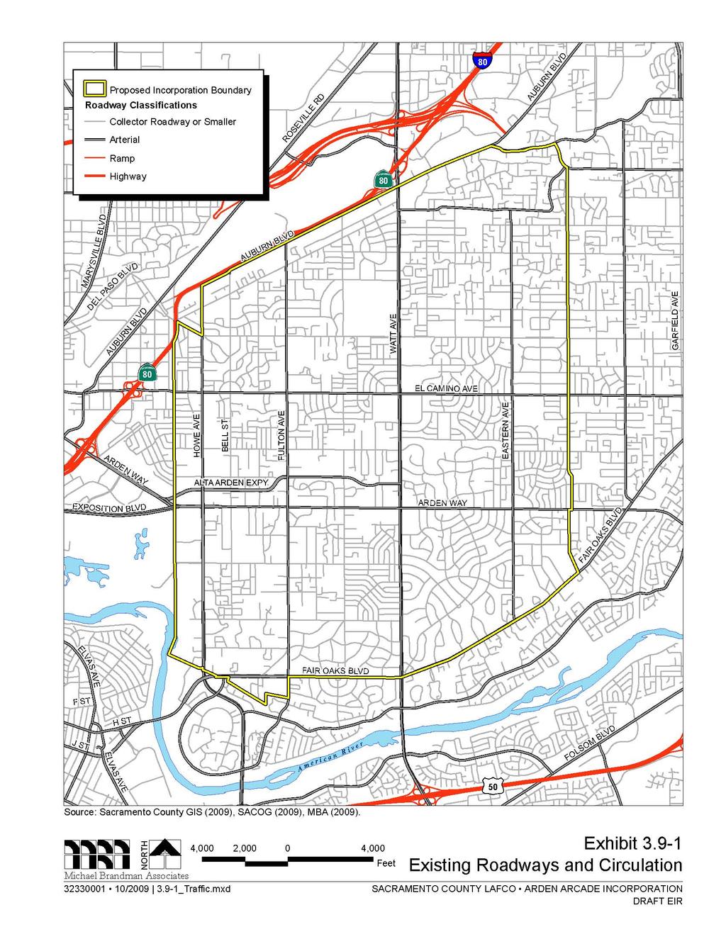
1 Sacramento LAFCo - Incorporation of Arden Arcade Traffic and Transportation Traffic and Transportation Summary This section describes the existing traffic and transportation conditions and potential effects from Project implementation on the proposed incorporation area Environmental Setting Introduction The proposed incorporation area s roadway network includes state highways, federal interstates, and County and City streets (arterial, collector, and local streets). The roadway system within the incorporation area is shown in Exhibit The dominant mode of travel within the proposed incorporation area is the automobile. The 2006 American Community Survey (U.S. Census 2007) includes data on the modes people in the Arden Arcade geographic area use to travel to work. Approximately 85 percent of all Arden Arcade residents traveled from home to work by car, truck, or van in 2006, of which 10 percent traveled in a carpool of two or more persons. Public transit served approximately three percent of residents commuting to work. Bicycle and pedestrian travel accounted for approximately five percent of work trips. Approximately five percent of residents work from home and less than two percent use a different form of transportation than those specified above. Commuting to work is one of many reasons persons travel. The data from Sacramento Area Council of Governments 2000 Household Travel Survey (SACOG 2001) shows the range of travel purposes for residents in the Sacramento region, including all of Sacramento, Yolo, Yuba, and Sutter counties, and the western portions of Placer and El Dorado counties: 28 percent for work 12 percent for education 20 percent for personal business/other 5 percent for visiting/recreational 7 percent for meals 7 percent to serve passenger 9 percent for work-/school-based Many of the above purposes occur in the late afternoon or early evening, which is why the period of 4:00 to 6:00 p.m. tends to be the most congested. However, localized hot spots can occur at other times of day due to schools, special events, recreational facilities, etc. Existing Transportation System Roadways The roadway network within the proposed incorporation boundary consists of thoroughfare, arterial, collector, local and limited access roadways (Exhibit 3.9-1). The incorporation boundary is adjacent Michael Brandman Associates 3.9-1
2 Traffic and Transportation Sacramento LAFCo - Incorporation of Arden Arcade to one freeway (Business-80). The most common type of major roadway within the proposed incorporation area is a four-lane arterial. The County s Final Draft Circulation Element (Sacramento County 2007) provides the following functional classification of roadways present in the incorporation area. Freeways Freeways provide for high-speed through-traffic movement on continuous routes with full access control. Freeways connect points within the County and link the County to other parts of the state. Business-80 is the only freeway near the proposed incorporation area. Business-80 abuts the northwest border of the proposed incorporation area. Business-80 is officially named State Route 51 pursuant to Streets and Highways Codes (SHC) Section 351. However, SHC Section indicates that it is signed as Interstate Business Loop 80. In 1996, the Sacramento Area Council of Governments (SACOG) decided to name the entire Business-80 freeway as the Capital City Freeway. In 2006, Caltrans traffic count (Caltrans 2007) indicated that the average annual daily traffic (AADT) of northbound traffic on Interstate Business-80 at Fulton Avenue was 141,000 and southbound AADT was 131,000. Caltrans 2005 truck counts (Caltrans 2006) show that truck traffic represents only 5.7 percent of the total traffic on this stretch of Business-80. Thoroughfares Thoroughfares provide for mobility within the County an the proposed incorporation area, carrying through traffic on continuous routes, and providing transportation links between major residential, employment, commercial, and retail areas. Access to abutting private property and intersecting local streets is generally restricted. Thoroughfares generally have the following functional characteristics: Thoroughfares are typically developed as six-lane roadways with a raised center median. Bikeways along designated thoroughfares may be Class I, Class II, or Class III facilities. Access to a thoroughfare occurs at intersections with other thoroughfares, arterials, and collectors. Access to and from local streets and private properties may be restricted to right turn movements only, using islands and turn lanes. Direct access points are located at sufficient intervals from each other and from public roads to maintain the safety and the traffic carrying capacity of the roadway. Within the Arden Arcade incorporation area, several roadways are designated as thoroughfares. Watt Avenue is a thoroughfare throughout the entire proposed incorporation area. Other designated thoroughfares are Fair Oaks Boulevard between the project s western boundary and Eastern Avenue; Howe Avenue from the project s southern boundary to Arden Way; Arden Way from the project s western boundary to just east of Howe Avenue; and Auburn Boulevard from Watt Avenue to the project s northern boundary Michael Brandman Associates
3
4 Sacramento LAFCo - Incorporation of Arden Arcade Traffic and Transportation Traffic counts were obtained from the Sacramento County Department of Transportation s Traffic Counts website (SacDOT 2007) and are presented in Table Table 3.9-1: 2006 Roadway Traffic Counts Street Segment Classification Total Daily Volume Alta Arden Expressway East of Howe Limited Access Roadway 17,607 Arden Way East of Eastern Thoroughfare 17,929 Arden Way East of Morse Thoroughfare 31,008 Auburn Boulevard East of Watt Thoroughfare 26,448 Bell Street North of Northrop Collector 8,568 Cottage Way West of Watt Collector 8,782 Eastern Avenue North of Fair Oaks Arterial 16,290 Eastern Avenue North of Marconi Arterial 16,712 Edison Avenue West of Fulton Arterial 7,498 Edison Avenue West of Watt Arterial 3,533 El Camino Avenue East of Eastern Arterial 20,617 El Camino Avenue East of Fulton Arterial 24,496 El Camino Avenue East of Watt Arterial 21,478 Ethan Way South of El Camino Arterial 9,714 Fair Oaks Boulevard East of Eastern Arterial 30,253 Fair Oaks Boulevard West of Eastern Thoroughfare 37,957 Fair Oaks Boulevard East of Watt Thoroughfare 38,316 Fulton Avenue North of Arden Arterial 30,266 Fulton Avenue South of El Camino Arterial 31,805 Fulton Avenue South of Marconi Arterial 33,209 Fulton Avenue South of Northrop Arterial 29,442 Howe Avenue North of Alta Arden Arterial 28,956 Howe Avenue North of Arden Arterial 30,390 Howe Avenue North of El Camino Arterial 18,819 Howe Avenue North of Fair Oaks Thoroughfare 53,463 Hurley Way East of Bell Collector 13,866 Hurley Way East of Howe Collector 14,919 Hurley Way West of Watt Collector 7,497 Marconi Avenue East of Eastern Arterial 24,812 Michael Brandman Associates 3.9-5
5 Traffic and Transportation Sacramento LAFCo - Incorporation of Arden Arcade Table (cont.): 2006 Roadway Traffic Counts Street Segment Classification Total Daily Volume Marconi Avenue East of Fulton Arterial 29,015 Marconi Avenue East of Howe Arterial 22,336 Mission Avenue North of Fair Oaks Collector 2,338 Morse Avenue South of Alta Arden Collector 8,426 Morse Avenue South of Cottage Way Collector 10,160 Morse Avenue North of Fair Oaks Collector 4,548 Morse Avenue North of El Camino Collector 2,767 Northrop Avenue East of Howe Collector 10,241 Watt Avenue North of El Camino Thoroughfare 51,968 Watt Avenue North of American River Bridge Thoroughfare 91,373 Watt Avenue South of Arden Thoroughfare 57,416 Watt Avenue South of Auburn Thoroughfare 59,065 Watt Avenue North of Cottage Way Thoroughfare 57,450 Watt Avenue North of El Camino Thoroughfare 53,841 Watt Avenue North of Fair Oaks Thoroughfare 55,070 Watt Avenue North of Marconi Thoroughfare 54,689 Whitney Avenue West of Eastern Thoroughfare 9,011 Notes: Annual counts occurring in 2006 Source: SacDOT 2007 Arterials Arterials generally have four lanes and limited access. They provide a link between thoroughfares and collectors. Arterials can also provide for mobility and direct access within commercial and retail corridors through two-way left-turn lanes. Arterials have the following functional characteristics: Arterials are typically developed as four-lane roadways with either a center two-way left-turn lane or a raised center median. Bikeways along designated arterials may be Class I, Class II, or Class III facilities. Based on the function of a particular arterial, access may be provided to adjacent properties through a two-way left-turn lane or more restricted through a raised center median. Within the proposed incorporation area, several roadways have been designated as arterials, including Arden Way east of Howe Avenue, Fair Oaks Boulevard east of Eastern Avenue, Howe Avenue north Michael Brandman Associates
6 Sacramento LAFCo - Incorporation of Arden Arcade Traffic and Transportation of Arden Way, Auburn Boulevard south of Watt Avenue, Fulton Avenue, Marconi Avenue, El Camino Avenue, Whitney Avenue, Edison Avenue, Ethan Way, and Eastern Avenue. Traffic counts for 2006 are presented above in Table Collectors Collectors provide for internal mobility within communities, and connect local roads to thoroughfares and arterials. Direct access to abutting private property is generally be permitted. Collectors have the following functional characteristics: Collectors are typically developed as two-lane roadways. Bikeways along designated arterials may be Class I, Class II, or Class III facilities. Direct access to abutting private property shall generally be permitted. Collectors within the Arden Arcade incorporation area include Bell Street, Cottage Way, Hurley Way, Mission Avenue, and Morse Avenue. Local Roadways Local streets provide direct access to abutting property and connect with other local roads and collectors. Local streets are typically developed as two-lane undivided roadways. Access to abutting private property and intersecting streets is permitted. Limited Access Roadways Limited access roadways are intended to have limited access regardless of their lane capacity. Access limitations improve safety and promote traffic flow, increasing the capacity of the roadway without adding lanes. There are two types of limited access roadways in the County; 1) locally declared freeways as provided in the Streets and Highway Code, and 2) expressways as created under County Code. Business-80 is an example of a Streets and Highway Code freeway and Alta Arden Expressway from Ethan Way to Watt Avenue is a County declared freeway within the proposed incorporation area. Traffic count for the Alta Arden Expressway for 2006 is presented above in Table Roadway Capacity and Level of Service Level of Service (LOS) is a general measure of traffic operating conditions whereby a letter grade, from A (the best) to F (the worst), is assigned. These grades are based on estimates of roadway capacity according to the roadway s functional classification and number of lanes. These grades represent the perspective of drivers and are an indication of the comfort and convenience associated with driving. The LOS grades are generally defined as: LOS A represents free-flow travel with an excellent level of comfort and convenience and the freedom to maneuver. Michael Brandman Associates 3.9-7
7 Traffic and Transportation Sacramento LAFCo - Incorporation of Arden Arcade LOS B has stable operating conditions, but the presence of other road users causes a noticeable, though slight, reduction in comfort, convenience, and maneuvering freedom. LOS C has stable operating conditions, but the operation of individual users is substantially affected by the interaction with others in the traffic stream. LOS D represents high-density, but stable flow. Users experience severe restriction in speed and freedom to maneuver, with poor levels of comfort and convenience. LOS E represents operating conditions at or near capacity. Speeds are reduced to a low but relatively uniform value. Freedom to maneuver is difficult with users experiencing frustration and poor comfort and convenience. Unstable operation is frequent, and minor disturbances in traffic flow can cause breakdown conditions. LOS F is used to define forced or breakdown conditions. This condition exists wherever the volume of traffic exceeds the capacity of the roadway. Long queues can form behind these bottleneck points with queued traffic traveling in a stop-and-go fashion. In 2007, the County of Sacramento conducted a study for the purpose of a Development Fee Program (Sacramento County 2007b). The Development Fee Program helps fund improvements to the County s major roadway, transit, bicycle and pedestrian facilities that are needed to accommodate travel demand generated by new land development in the unincorporated portion of Sacramento County over the next 25 years. The County projected that housing units in unincorporated Sacramento County are expected to grow by 55 percent and employment is expected to grow by 43 percent. The study analyzed road segments and intersections in the unincorporated Sacramento County and calculated Levels of Service (LOS) for 2005 conditions and conditions in the year Segment Analysis Table shows the roadway segments in the proposed incorporation area. It shows the following six roadway segments with an LOS of F in 2005: Arden Way from Howe Avenue to Fulton Avenue; Fair Oaks Boulevard from Watt Avenue to Eastern Avenue; Fulton Avenue from El Camino Avenue to Arden Way; Howe Avenue from Marconi Avenue to El Camino Avenue; Howe Avenue from Hurley Way to Fair Oaks Boulevard; and Watt Avenue throughout the incorporation area. However, the study shows that an additional four roadway segments (listed below) will reach an LOS F and one segment (Howe Avenue from Marconi Avenue to El Camino Avenue) will lose its congestion and be reduced to an LOS of C by Arden Way from Fulton Avenue to Watt Avenue; Fair Oaks Boulevard from Fulton Avenue to Watt Avenue; Michael Brandman Associates
8 Sacramento LAFCo - Incorporation of Arden Arcade Traffic and Transportation Fair Oaks Boulevard from Eastern Avenue to Arden Way; and Fulton Avenue from Arden Way to Fair Oaks Boulevard. Intersection Analysis Table depicts the calculated LOS of intersections within the proposed incorporation area. It shows that in 2005, only the intersection of Watt Avenue and Fair Oaks Boulevard demonstrates an LOS of F. However, by the year 2032, even with the improvements projected by the Development Fee Program, an additional four intersections (listed below) will reach the congestion level of an LOS F. The Development Fee Program Document (Sacramento County 2007b) suggests additional intersections improvements of two left-turn lanes in all directions for Eastern Avenue at El Camino Avenue and two northbound left turn lanes for Watt Avenue at Alta Arden Expressway would sufficiently reduce congestion on these two intersections to less than an LOS F. Howe Avenue and Fair Oaks Boulevard; Howe Avenue and Alta Arden Expressway; Eastern Avenue at El Camino Avenue; and Watt Avenue at Alta Arden Expressway Metropolitan Transportation Plan The 2035 Metropolitan Transportation Plan (MTP) (SACOG 2008) provides summary information regarding various capital improvement funding programs, as well as project summary information for projects selected for implementation during the 28-year plan period. Projects included the 2035 MTP fall into several categories including bicycle and pedestrian ways; public-transit routes, including bus, light rail, heavy rail passenger lines, and associated facilities such as stations or terminals and their grounds;; and transportation management facilities and services, including demand-, system-, and operations-management. MTP projects in the Project area include the following: Arden Way. Intelligent Transportation Systems (ITS) improvements from Watt Avenue to Fair Oaks Boulevard. Auburn Boulevard. Enhancements from Howe Avenue to Watt Avenue. This project will initiate a study to develop a special planning area ordinance and streetscape master plan for the Auburn Boulevard Corridor. Howe Avenue Corridor Mobility Strategies. May include roadway widening from Arden Way to Auburn Boulevard, transit enhancements, and other improvements. Hurley Way. Revitalization from Watt Avenue to American River Parkway: perform planning for reconfiguration of the street, including analysis, design and planning of sidewalk infrastructure, pedestrian crosswalks, transit facilities, intersection improvements. Michael Brandman Associates 3.9-9
9 Traffic and Transportation Sacramento LAFCo - Incorporation of Arden Arcade Fulton Avenue. Enhancements from Arden Way to Auburn Boulevard. Construct landscaped medians, streetscaping, sidewalks, bikeways, lighting, transit shelters, and landscaped medians (Phase II). Bike/Pedestrian Improvements Bikeway Master Plan implementation in various locations. Bus Stop Accessibility Improvements. Bus Stop Accessibility Improvements in Sacramento County at various locations. Commercial Corridor Enhancements. Streetscaping in various locations in Sacramento: provide streetscaping, lighting, and other safety enhancements to enhance bicycle and pedestrian use. Bus Stop Accessibility Improvements. Bus Stop Accessibility Improvements in Sacramento County at various locations. Corridor Mobility Strategies. Implement identified investments that may include improved intersections, technology deployment, and multimodal complete streets at various locations. Bus Stop Accessibility Improvements. Bus Stop Accessibility Improvements in Sacramento County at various locations. Intersection Improvements. At various locations, provide turning movements, improve intersections, and install traffic signals. LED Signal Heads. Install LED signal heads at various locations in Sacramento County. Left-Turn Lanes. Various locations: installation of left-turn lanes in accordance with the County DOT s Project Priority List. Pavement Reconstruction and Resurfacing. Pavement reconstruction/resurfacing program throughout Sacramento County at various locations. Pedestrian Master Plan Implementation. Construct pedestrian facilities and improvements on El Camino Avenue, from Ethan way to Mission Avenue and Marconi Avenue from Fair Oaks to Walnut Avenue, in accordance with the adopted Sacramento County Pedestrian Master Plan. Pedestrian Master Plan Implementation. New sidewalks and walkways, pedestrian signals, crossings, and intersection improvements in Sacramento County at various locations. In compliance with the County s Master Plan. Bus Stop Accessibility Improvements. Bus Stop Accessibility Improvements in Sacramento County at various locations Michael Brandman Associates
10 Sacramento LAFCo - Incorporation of Arden Arcade Traffic and Transportation Table 3.9-2: Summary of Roadway Segment Level of Service Analysis Roadway Segment Lanes Daily Volume LOS From To GP Alta Arden Express Way Howe Avenue Fulton Avenue ,900 18,000 A A Alta Arden Express Way Fulton Avenue Watt Avenue ,100 18,800 A A Arden Way Howe Avenue Fulton Avenue ,400 42,300 F F Arden Way Fulton Avenue Watt Avenue ,000 36,000 E F Arden Way Watt Avenue Eastern Avenue ,500 23,100 B B Arden Way Eastern Avenue Fair Oaks Boulevard ,300 20,300 A A Auburn Boulevard Watt Avenue Winding Way ,400 24,800 C B Eastern Avenue Fair Oaks Boulevard Arden Way ,700 22,400 A B Eastern Avenue Arden Way El Camino ,100 28,300 C C Eastern Avenue El Camino Marconi Avenue ,100 25,600 B C Eastern Avenue Marconi Avenue Whitney Avenue ,100 19,400 A A Eastern Avenue Whitney Avenue Edison Avenue ,600 11,900 A B El Camino Howe Avenue Fulton Avenue ,000 27,900 B B El Camino Fulton Avenue Morse Avenue ,500 27,600 C C El Camino Morse Avenue Watt Avenue ,300 26,600 C C El Camino Watt Avenue Walnut Avenue ,900 24,600 B B Fair Oaks Boulevard Howe Avenue Fulton Avenue ,200 34,100 B B Fair Oaks Boulevard Fulton Avenue Watt Avenue ,900 37,800 E F Fair Oaks Boulevard Watt Avenue Eastern Avenue ,800 47,900 F F Fair Oaks Boulevard Eastern Avenue Arden Way ,200 37,500 E F Fulton Avenue Edison Avenue Marconi Avenue ,400 28,000 C C Michael Brandman Associates
11 Traffic and Transportation Sacramento LAFCo - Incorporation of Arden Arcade Table (cont.): Summary of Roadway Segment Level of Service Analysis Roadway Segment Lanes Daily Volume LOS From To GP Fulton Avenue Marconi Avenue El Camino ,500 32,000 D D Fulton Avenue El Camino Alta Arden Expressway ,100 40,200 F F Fulton Avenue Alta Arden Expressway Arden Way ,500 41,800 F F Fulton Avenue Arden Way Fair Oaks Boulevard ,800 39,800 E F Howe Avenue Auburn Boulevard Marconi Avenue ,200 9,000 A A Howe Avenue Marconi Avenue El Camino ,800 27,100 F C Howe Avenue El Camino Alta Arden Expressway ,900 33,900 D E Howe Avenue Alta Arden Expressway Arden Way ,500 36,900 A B Howe Avenue Arden Way Hurley Way ,700 49,800 C E Howe Avenue Hurley Way Fair Oaks Boulevard ,600 64,400 F F Watt Avenue Auburn Avenue Edison Avenue ,500 73,400 F F Watt Avenue Edison Avenue Marconi Avenue ,200 64,900 F F Watt Avenue Marconi Avenue El Camino ,600 63,700 F F Watt Avenue El Camino Arden Way ,200 68,600 F F Watt Avenue Arden Way Fair Oaks Boulevard ,400 66,700 F F Winding Way Auburn Boulevard College Oak Drive ,400 22,000 F F Source: Sacramento County 2007b Michael Brandman Associates
12 Sacramento LAFCo - Incorporation of Arden Arcade Traffic and Transportation Table 3.9-3: Summary of Intersection Level of Service Analysis North-South Street Name East-West Street Name LOS Vol/Cap 1 Delay 2 LOS Vol/Cap 1 Delay 2 Howe Avenue Fair Oaks Boulevard E 0.95 F 1.04 Howe Avenue Arden Way C 0.77 C 0.77 Howe Avenue Alta Arden Parkway E 0.94 F 1.16 Howe Avenue El Camino D 0.84 D 0.87 Howe Avenue Marconi Avenue D 0.80 D 0.85 Howe Avenue Edison Avenue B 12.0 B 10.6 Fulton Avenue Fair Oaks Boulevard A 1.0 A 2.1 Fulton Avenue Arden Way E 0.91 D 0.84 Fulton Avenue Alta Arden Expressway C 0.73 E 0.91 Fulton Avenue El Camino E 0.91 E 0.90 Fulton Avenue Marconi Avenue D 0.82 C 0.78 Fulton Avenue Edison Avenue B 0.61 B 0.65 Eastern Avenue Fair Oaks Boulevard C 0.77 D 0.82 Eastern Avenue Arden Way B 0.68 B 0.68 Eastern Avenue El Camino E 0.93 F 1.02 Eastern Avenue Marconi Avenue D 0.90 E 0.94 Eastern Avenue Whitney Avenue A 0.46 A 0.53 Auburn Boulevard Winding Way B 0.69 C 0.77 Watt Avenue Fair Oaks Boulevard F 1.01 F 1.48 Watt Avenue Arden Way D 0.84 D 0.84 Watt Avenue Alta Arden Expressway C 0.75 F 1.13 Michael Brandman Associates
13 Traffic and Transportation Sacramento LAFCo - Incorporation of Arden Arcade Table (cont.): Summary of Intersection Level of Service Analysis North-South Street Name East-West Street Name LOS Vol/Cap 1 Delay 2 LOS Vol/Cap 1 Delay 2 Watt Avenue El Camino Avenue D 0.86 D 0.84 Watt Avenue Marconi Avenue E 0.92 D 0.90 Watt Avenue Whitney Avenue D 0.82 D 0.86 Watt Avenue Edison Avenue E 0.92 E 0.92 Watt Avenue Auburn Boulevard D 0.88 E 0.94 Notes: 1 Volume to capacity ratio (for signalized intersections) 2 Delay in seconds (for stop signs) Source: Sacramento County 2007b Michael Brandman Associates
14 Sacramento LAFCo - Incorporation of Arden Arcade Traffic and Transportation Watt Avenue Enhancements Phase 2. Watt Avenue from Capital City Freeway (SR-51) to Jackson Hwy. (SR-16): construct curb, gutter, sidewalks, bikeways, lighting, transit shelters, and landscaped medians. Bikeway Master Plan Construction Phase 2. Various locations throughout County: construct on-street bikeways, including shoulder widening to provide shoulders for the bike lanes. Fulton Avenue Enhancements Phase 2. Fulton Avenue from Arden Way to Auburn Boulevard: construct landscaped medians, streetscaping, sidewalks, bikeways, lighting, transit shelters, and landscaped medians. Pedestrian Master Plan Implementation Project. Construct pedestrian facilities and improvements in various locations throughout Sacramento County in accordance with the adopted Sacramento County Pedestrian Master Plan. The project includes improvements to existing corridors to enhance pedestrian safety and mobility, including sidewalk and walkway construction, pedestrian signal installation, improvements to existing signalized and nonsignalized intersections and pedestrian crossings, and other improvements to benefit pedestrian access and safety. Watt Avenue Bus Rapid Transit. Develop a bus rapid transit corridor on Watt Avenue between Folsom Boulevard and McClellan Business Park. Transit System Sacramento Regional Transit provides transit service to the greater Sacramento area. Within the proposed incorporation area, Sacramento Regional Transit provides bus routes on many of the thoroughfare and arterial roadways (see Exhibit 3.9-2). Light rail does not serve the proposed incorporation area and no Transit Centers exist within the proposed incorporation area. The two nearest Transit Centers are at the Arden Fair shopping mall and California State University Sacramento campus, which are east and south of the Project area, respectively. Bicycle and Pedestrian System The 2010 City/County Bikeway Master Plan (Sacramento City/County 1993/1995) was developed to serve the recreational and transportation needs of the public. The goal of the 2010 City/County Bikeway Master Plan was to develop a comprehensive plan, which will meet the needs of all bicyclists. On-road bicycle facilities are defined in the 2010 Plan as: Class I Bikeways (Bike Paths) are the most popular type of facility. This is substantiated by the Master Plan bicycle survey. Because the availability of uninterrupted right-of-ways are limited, this type of facility is difficult to locate and expensive to build. In addition, the position of bike paths may not serve large numbers of bicycle commuters. Prime locations for Michael Brandman Associates
15 Traffic and Transportation Sacramento LAFCo - Incorporation of Arden Arcade bike paths are areas such as power line easements, utility easements, canal banks, river levees, drainage easement, abandoned railroad or highway right-of-ways, or regional community parks. Class II Bikeways (Bike Lanes) are for preferential use by bicycles and are established within the paved area of the roadway. Bike lanes are intended to promote an orderly flow of bicycle and vehicle traffic. This type of facility is established by using the appropriate striping, legends, and signs within a roadway right-of-way. Bike lanes are located on arterial and collector streets as designated in the Bikeway Master Plan. Class III Bikeways (Bike Routes) are facilities shared with motor vehicle traffic. Bike routes must be of benefit to the bicyclist and offer a higher degree of service than adjacent streets. They provide for specific bicycle demand and may be used to connect discontinuous segments of bike lane streets. In addition, bike routes are located on residential streets, and rural roads. If the pavement width is sufficient and traffic volume/speeds warrant, an edge line may be painted to further delineate the bike route. Bike routes are signed with the G-93 Bike Route marker, but no striping or legends are required. The 2010 Plan contains bikeway segments of each street listed by community, a summary of the total program, and a summary of the five-year and ten-year programs. Table shows route location, mileage, and class of bicycle routes in the proposed incorporation area. Table 3.9-4: Bikeway Inventory for Arden Arcade Area Alta Arden Expressway Street Location Mileage 5 yrs 10 yrs Ethan Way to Watt Avenue 2.04 II Arden Way Morse Avenue to McClaren Drive 3.14 II Auburn Boulevard Howe Avenue to Watt Avenue 1.94 III II Bell Street Northrop Avenue to Auburn Avenue 3.06 II Eastern Avenue F.O.B. to Edison Avenue 3.58 II Edison Way Howe Avenue to Cypress Avenue 3.73 II El Camino Avenue Ethan Way to Walnut Avenue 3.99 II Ethan Way Hurley Way to El Camino Avenue 1.02 III II Howe Avenue Hurley Way to Business II Hurley Way Ethan Way to Watt Avenue 1.97 II Marconi Avenue I-80 to Walnut Avenue 3.94 II Maryal Avenue Watt Avenue to El Camino Avenue 1.06 II Morse Avenue F.O.B. to Auburn Boulevard 4.03 II Northrop Avenue Howe Avenue to Watt Avenue 1.24 II Michael Brandman Associates
16 Sacramento LAFCo - Incorporation of Arden Arcade Traffic and Transportation Table (cont.): Bikeway Inventory for Arden Arcade Area Street Location Mileage 5 yrs 10 yrs Watt Avenue Middle of American River to Auburn Boulevard 4.82 III Whitney Avenue Morse Avenue to Walnut Avenue 2.46 II Source: Sacramento City/County 1993/1995 In preparing the Sacramento County Pedestrian Master Plan (SacDOT 2007b), the County of Sacramento Department of Transportation (SacDOT) conducted a five-month survey of pedestrian facilities to document existing conditions within the public rights-of-way. The inventory focused on heavily used roadways and intersections and on those roadways and intersections serving governmental, public service and commercial uses. Highlights of the findings include: For roadways surveyed, approximately 75 percent of County roadways have sidewalks on one or both sides and 25 percent do not have sidewalks on either side of the street. Approximately 66 percent of all corners surveyed have rolled curbs, approximately 16 percent have vertical curbs, and 18 percent do not have curbs. Approximately 41 percent of all developed corners have curb ramps. Of these, approximately 57 percent were older perpendicular curb ramps with flared sides and approximately 40 percent were newer parallel pan-type curb ramps. The Pedestrian Master Plan also contains an implementation plan section that identifies projects that improve pedestrian safety and access. This section lists the highest-ranking projects and programs included in the Pedestrian Capital Improvement Program (CIP). The Arden Arcade area has almost $8 million set aside for CIP projects Regulatory Framework Federal There are thousands of federal laws and regulations related to goods movement, homeland security, street maintenance, traffic safety, and transportation funding. The following legislation established the framework for transportation planning at the federal level: Intermodal Surface Transportation Efficiency Act (ISTEA) approved in Transportation Efficiency Act for the 21st Century (TEA-21) approved in 1988 to replace ISTEA. This measure has expired; however, it has been temporarily extended on several occasions. Michael Brandman Associates
17 Traffic and Transportation Sacramento LAFCo - Incorporation of Arden Arcade State The California Department of Transportation (Caltrans) operates and maintains State Route 51 (Business-80), which provide direct regional access to the proposed incorporation area. Caltrans has accepted a standard of LOS D in rural areas and LOS E in urbanized areas. The established LOS standard for State Route 16 and U.S. 50 (both located south of the Incorporation Area) is LOS E. Potential development within the proposed incorporation area will use State Route 51 (Business-80) and rely on access to existing interchanges with these facilities. Any changes to State Route 51 mainlines or existing interchanges would require approval by Caltrans. Regional SACOG is responsible for the preparation of, and updates to, the Metropolitan Transportation Plan (MTP) and the corresponding Metropolitan Transportation Improvement Program (MTIP). The MTP provides a 20-year transportation vision and corresponding list of projects. The MTIP identifies short-term projects (seven-year horizon) in more detail. The current MTP is the 2006 Metropolitan Transportation Plan. SACOG is also responsible for the oversight and distribution of most federal and state transportation funding sources. SACOG also develops the air quality plans and compliance measures, which incorporate mobile (vehicular) pollution sources. Local Roadway System The Sacramento County General Plan (1993) contains Policy CI-22, which states that the County shall apply the following LOS standards for planning roads in the unincorporated areas. 1. Rural Collectors: LOS D 2. Urban area roads: LOS E Under this policy and Policy CI-23, land development projects that cause the LOS on a County roadway to deteriorate below these levels are responsible for implementing mitigation measures to maintain an adequate LOS. Since the new city would be required to adopt the Sacramento County General Plan and until a new city general plan is prepared and adopted, this EIR utilizes the LOS standards from Policy CI-22 as the criteria to determine impact significance for roadways in the incorporation area. Transit System Similar to the roadway system, the Sacramento County General Plan sets forth applicable policies regarding transit service in the proposed incorporation area. Policy CI-13 of the General Plan states that the County shall provide a minimum level of transit service in suburban areas. This policy was Michael Brandman Associates
18
19 Sacramento LAFCo - Incorporation of Arden Arcade Traffic and Transportation the basis for establishing an impact threshold of significance that considers any disruption to existing transit service in the incorporation area as a significant impact. In the greater Sacramento area, transit service is provided by Regional Transit. The project is located in Northern Sacramento County where existing transit service is limited. The existing fixed -route service provided by Regional Transit with the proposed incorporation area is as follows: Route 20 Cottage Route 22 Arden Route 23 El Camino Route 25 Marconi Route 26 Fulton Route 29 Arden-California Avenue Route 80 Watt Avenue-Elkhorn Route 82 Howe-65 th Street Route 84 Watt Avenue-North Highlands Route 87 Howe Ten bus routes are provided by Regional Transit within the proposed incorporation area. Routes 20, 22, 23, 25, 26, 80, 84, and 87 connect to the Light Rail Blue Line that serves the north area and downtown. Routes 26, 80, 82, 84 also connect to the Light Rail Yellow Line that serves Folsom and downtown. Route 29 connects the proposed incorporation area directly to downtown. Bicycle/Pedestrian System The Sacramento City/County 2010 Bikeway Master Plan (Sacramento City/County 1993/1995) identifies bikeways throughout unincorporated Sacramento County (Exhibit 3.9-3) Project Impact Analysis Methodology for Analysis The discussion below describes the steps that were followed to analyze the potential impacts to the transportation system from implementation of the project. Approval of the project as defined for this EIR would not change the Sacramento County General Plan land use designations for the area within the proposed incorporation boundary. Further, implementation of the project would not grant approval for new development projects without first conducting detailed project level environmental review and clearance. Potential impacts to the roadway system were analyzed by utilizing existing traffic count information and forecasts for daily traffic volumes for the proposed incorporation area as identified in the Sacramento County Development Fee Program Document. Potential impact to the transit system, bicycle, and pedestrian systems were determined by evaluating the proposed incorporation description in terms of the significance criteria listed below. Michael Brandman Associates
20 Traffic and Transportation Sacramento LAFCo - Incorporation of Arden Arcade It should also be mentioned that the proposed incorporation represent existing-plus project and cumulative-plus project conditions for the roadway system analysis. This unique situation occurs because the project as defined in this EIR would not change the physical condition or operation of the existing roadway system, Instead, implementation of the project may affect the future operation of the roadway system by increasing traffic volumes beyond levels anticipated in the Sacramento County General Plan due to the potential for increased urbanization within the proposed incorporation boundary. Thresholds of Significance For the purposes of this EIR, to determine whether traffic and transportation impacts are significant environmental effects, the following questions are analyzed and evaluated. Would the project: Cause an increase in traffic, which is substantial in relation to the existing traffic load and capacity of the street system (i.e., result in a substantial increase in either the number of vehicle trips, the volume to capacity ratio on roads, or congestion at intersections)? Exceed, either individually or cumulatively, a level of service standard established by the county congestion management agency for designated roads or highways? Result in a change in air traffic patterns, including either an increase in traffic levels or a change in location that results in substantial safety risks? Substantially increase hazards due to a design feature (e.g., sharp curves or dangerous intersections) or incompatible uses (e.g., farm equipment)? Result in inadequate emergency access? Result in inadequate parking capacity? Conflict with adopted policies, plans or programs supporting alternative transportation (e.g. bus turnouts, bicycle racks)? Impact Statements and Mitigation Discussions Traffic Increase Impact 3.9-1: The project would not cause an increase in traffic, which is substantial in relation to the existing traffic load and capacity of the street system (i.e., result in a substantial increase in either the number of vehicle trips, the volume to capacity ratio on roads, or congestion at intersections). Impact Analysis Approval of the project is not expected to generate increased traffic in the immediate proposed incorporation area beyond that previously authorized by the provisions of the County General Plan and zoning ordinance. Following the incorporation, traffic volumes would be similar to the existing conditions Michael Brandman Associates

21
22 Sacramento LAFCo - Incorporation of Arden Arcade Traffic and Transportation As mentioned above, the new city would adopt the County General Plan, which would result in general continuation of the existing and approved land use pattern that was previously analyzed in the 1993 County General Plan EIR. As discussed above, the proposed incorporation area currently has existing LOS deficiencies for Roadway Segments and Intersections; however, the project will not result in an increase in LOS deficiencies nor will it correct them. As identified in the Government Code Section (a) If unincorporated territory.is incorporated, all roads and highways or portions of a road or highway in the territory which had been accepted into the county road system pursuant to Section 941 of the Streets and Highways Code shall become a city streets on the effective date of the incorporation. Likewise subsection (c) of the same section states that Nothing in subdivision (a) requires a city to improve the affected road or highway to city standards resulting in a less than significant impact after project implementation. Pending project approval (i.e. incorporation) the newly formed City of Arden Arcade would have land use control over the intensity and development potential of vacant lands (see section 3.5 Land Use). To develop the vacant lands within their authority, new project applicants will be required to go through the entitlement, environmental review, and the project approval process; at which time an analysis of project specific traffic impacts will be identified for all new projects in the proposed incorporation area. However, there is the potential for the City of Arden Arcade to develop vacant land to be inconsistent with the existing County General Plan and EIR, resulting in a potentially significant impact. Implementation of Mitigation Measure (Land Use and Planning) will require the City of Arden Arcade to develop vacant lands consistent with the adopted County General Plan until such time the City of Arden Arcade develops and adopts a General Plan and EIR analyzing the impacts of increased development intensities. In this context, the project is not expected to result in any new traffic with respect to worker trips and/or deliveries to and from the proposed incorporation area, resulting in a less than significant impact after project implementation. As a result, given no change in the existing condition and restrictions of future development conditions, the project would have a less than significant impact on existing traffic roadway capacities. Significance Determination Before Mitigation Less than significant impact. Mitigation Measures See Land Use Mitigation Measure: MM Significance Determination After Mitigation Less than significant impact. Michael Brandman Associates
23 Traffic and Transportation Sacramento LAFCo - Incorporation of Arden Arcade Level of Service Standards Impact 3.9-2: The project would not exceed, either individually or cumulatively, a level of service standard established by the county congestion management agency for designated roads or highways. Impact Analysis As discussed above in Impact 3.9-1, the project would result in a continuation of the existing land use pattern and, thus, is comparable to existing conditions. In this context, it is reasonable to conclude that with no increases in traffic, the project would not exceed, either individually or cumulatively, County level of service standards. Significance Determination Before Mitigation No impact. Mitigation Measures None necessary. Significance Determination After Mitigation No impact. Air Traffic Patterns Impact 3.9-3: The project would not result in a change in air traffic patterns, including either an increase in traffic levels or a change in location that results in substantial safety risks. Impact Analysis The project does not involve use of air transit, nor is it expected to cause any change in air traffic patterns. No impact is expected. Significance Determination Before Mitigation No impact. Mitigation Measures No mitigation is required. Significance Determination After Mitigation No impact. Traffic Hazards Impact 3.9-4: The project would not substantially increase hazards due to a design feature (e.g., sharp curves or dangerous intersections) or incompatible uses (e.g., farm equipment). Impact Analysis The project would not include the design of any roadway improvements Michael Brandman Associates
24 Sacramento LAFCo - Incorporation of Arden Arcade Traffic and Transportation Significance Determination Before Mitigation No mitigation is required. Mitigation Measures None necessary. Significance Determination After Mitigation No impact. Emergency Access Impact 3.9-5: The project would not result in inadequate emergency access. Impact Analysis As provided above, the project involves no increases in vehicle trips or physical improvements to the roadway system. In this context, the project would not result in any physical disruptions to existing emergency access. Significance Determination Before Mitigation No impact. Mitigation Measures No mitigation is required. Significance Determination After Mitigation No impact. Parking Capacity Impact 3.9-6: The project would not result in inadequate parking capacity. Impact Analysis The project involves no construction activities and therefore, no additional parking for workers and equipment would be required. In addition, the project involves no changes in existing land use, which could indirectly require additional parking. Significance Determination Before Mitigation No impact. Mitigation Measures No mitigation is required. Significance Determination After Mitigation No impact. Michael Brandman Associates
25 Traffic and Transportation Sacramento LAFCo - Incorporation of Arden Arcade Conflict with Alternative Transportation Impact 3.9-7: The Project would not conflict with adopted policies, plans or programs supporting alternative transportation (e.g. bus turnouts, bicycle racks). Impact Analysis As described above, local transit, bus, and van service is provided by the Regional Transit. The project proposes no change in local means of alternative transportation and, therefore, the project would not create conditions that could conflict with adopted policies supporting alternative transportation. However, the project applicants propose no changes regarding coordination with other district providing services to the region and the project description does not identify how transit service will be provided after incorporation; therefore existing transit service could be discontinued, resulting in a potentially significant impact. Significance Determination Before Mitigation Potentially significant impact. Mitigation Measures Implement Mitigation Measure b. Significance Determination After Mitigation and Supporting Rationale Less than significant impact. Mitigation Measure b will ensure that the existing level of transit service is not disrupted because of incorporation and ensure the project s consistency with LAFCO standards for public service provisions associated with the provision of transit services. Safe Access Impact 3.9-8: The project would provide safe access and would not obstruct access to nearby uses or fail to provide for future street right of way. Impact Analysis The project proposes no access improvements; therefore, the project would not obstruct access to nearby uses or fail to provide for future street right of way. Significance Determination Before Mitigation No impact. Mitigation Measures No mitigation is required. Significance Determination After Mitigation No impact Michael Brandman Associates
Circulation in Elk Grove includes: Motor vehicles, including cars and trucks
 Circulation, as it is used in this General Plan, refers to the many ways people and goods move from place to place in Elk Grove and the region. Circulation in Elk Grove includes: Motor vehicles, including
3.9 - Transportation and Traffic
 Transportation and Traffic 3.9 - Transportation and Traffic This section describes the potential transportation and traffic effects of project implementation on the project site and its surrounding area.
3.0 PROJECT DESCRIPTION
 The following section of the Draft EIR contains a description of the proposed Elk Grove Boulevard/SR 99 Interchange Modification project, consistent with the requirements of CEQA Guidelines Section 15124.
Recommended Roadway Plan Section 2 - Land Development and Roadway Access
 Recommended Roadway Plan Section 2 - Land Development and Roadway Access SECTION 2 Land Development and Roadway Access 2.1 Land Use and Access Management The Federal Highway Administration (FHWA) defines
ACTIVE TRANSPORTATION
 ACTIVE TRANSPORTATION Mobility 2040 Supported Goals Improve the availability of transportation options for people and goods. Support travel efficiency measures and system enhancements targeted at congestion
Clackamas County Comprehensive Plan
 ROADWAYS The County s road system permits the movement of goods and people between communities and regions, using any of a variety of modes of travel. Roads provide access to virtually all property. They
3.16 TRANSPORTATION, CIRCULATION, AND PARKING Regulatory Setting Environmental Setting ROADWAY SYSTEM
 3.16 TRANSPORTATION, CIRCULATION, AND PARKING This section assesses the potential for implementation of the Orchard Park Redevelopment component of the 2018 LRDP to result in impacts related to transportation,
New Measure A Expenditure Categories DEFINITIONS OF ELIGIBLE EXPENDITURES Adopted March 8, 2007
 New Measure A Expenditure Categories DEFINITIONS OF ELIGIBLE EXPENDITURES Adopted March 8, 2007 City Street and County Road Maintenance Program The preservation and keeping of public street and road rights-of-way
CITY OF COCOA BEACH 2025 COMPREHENSIVE PLAN. Section VIII Mobility Element Goals, Objectives, and Policies
 CITY OF COCOA BEACH 2025 COMPREHENSIVE PLAN Section VIII Mobility Element Goals, Objectives, and Policies Adopted August 6, 2015 by Ordinance No. 1591 VIII MOBILITY ELEMENT Table of Contents Page Number
Magnolia Place. Traffic Impact Analysis. Prepared for: City of San Mateo. Prepared by: Hexagon Transportation Consultants, Inc.
 Magnolia Place Traffic Impact Analysis Prepared for: City of San Mateo Prepared by: Hexagon Transportation Consultants, Inc. Updated January 4, 2010 Table of Contents 1. Introduction...1 2. Existing Conditions...6
Route 7 Corridor Study
 Route 7 Corridor Study Executive Summary Study Area The following report analyzes a segment of the Virginia State Route 7 corridor. The corridor study area, spanning over 5 miles in length, is a multi
Classification Criteria
 SCHEDULE D TO RECOMMENDED OFFICIAL PLAN AMENDMENT NO. 40 SCHEDULE C-4 Road Criteria Criteria Traffic Service Objective Land Service/Access Typical Daily Traffic Volume Flow characteristics Travel Speed
2.0 Existing Conditions
 20 2.0 Existing Conditions 2.1 Land Use, Future Growth Patterns, Physical Barriers Geographic Overview Sutter County s land use pattern is characterized by extensive agricultural areas, significant natural
West Dimond Blvd Upgrade Jodhpur Street to Sand Lake Road
 West Dimond Blvd Jodhpur St to Sand Lake CSS Transportation Project Summary Municipality of Anchorage Project # 05 005 Project Manager: John Smith, P.E. (MOA PM&E) Project Administrator: Julie Makela,
Abrams Associates. Transportation Impact Analysis. City of Rocklin. Prepared for: David Mohlenbrok City of Rocklin 4081 Alvis Court Rocklin, CA 95677
 Transportation Impact Analysis Sierra College Boulevard Commercial Project City of Rocklin Prepared for: David Mohlenbrok City of Rocklin 081 Alvis Court Rocklin, CA 95677 Prepared by: 1875 Olympic Boulevard,
City of Wayzata Comprehensive Plan 2030 Transportation Chapter: Appendix A
 A1. Functional Classification Table A-1 illustrates the Metropolitan Council s detailed criteria established for the functional classification of roadways within the Twin Cities Metropolitan Area. Table
REGIONAL BICYCLE AND PEDESTRIAN DESIGN GUIDELINES
 REGIONAL BICYCLE AND PEDESTRIAN DESIGN GUIDELINES November 16, 2011 Deb Humphreys North Central Texas Council of Governments Bicycle and Pedestrian Advisory Committee Snapshot of the Guide 1. Introduction
APPENDIX D: SACRAMENTO URBAN AREA TRANSPORTATION PRIORITIES
 1 County County County County 2 Yolo Arterial Roadway Collector Roadway Urban Residential Street Rural Residential Roadway I-80 / U.S. 50 Bus/Carpool Lanes in both directions Richards Blvd PM Yol 80 0.237
Non-Motorized Transportation 7-1
 Non-Motorized Transportation 7-1 Transportation facilities no longer mean just accommodating a vehicle powered by a combustion engine. Pedestrian and non-motorized facilities are important modes of travel
5/7/2013 VIA . RE: University Village Safeway Expansion (P13-019)
") 5/7/2013 VIA EMAIL David Hung, Associate Planner Community Development Department, Current Planning Division City of Sacramento 300 Richards Boulevard, 3 rd Floor Sacramento, CA 95811 RE: University Village
5/7/2013 VIA EMAIL David Hung, Associate Planner Community Development Department, Current Planning Division City of Sacramento 300 Richards Boulevard, 3 rd Floor Sacramento, CA 95811 RE: University Village
Regional Transportation Needs Within Southeastern Wisconsin
 Regional Transportation Needs Within Southeastern Wisconsin #118274 May 24, 2006 1 Introduction The Southeastern Wisconsin Regional Planning Commission (SEWRPC) is the official areawide planning agency
This chapter describes the proposed circulation system and transportation alternatives associated with
 5.0 Circulation 5.1 OVERVIEW This chapter describes the proposed circulation system and transportation alternatives associated with West Landing, and summarize the information contained in the Existing
TRANSPORTATION TRAINING TOPICS. April 6, 2010
 TRANSPORTATION TRAINING TOPICS April 6, 2010 Roles of Transportation Providers Context and Policy Makers Division of Transportation and Traffic Other City Operations Other Transportation Operators CMA
City of Homewood Transportation Plan
 City of Homewood Transportation Plan Prepared for: City of Homewood, Alabama Prepared by: Skipper Consulting, Inc. May 2007 TABLE OF CONTENTS INTRODUCTION... 1 BACKGROUND INFORMATION... 1 EXISTING TRANSPORTATION
4. ENVIRONMENTAL IMPACT ANALYSIS 9. TRANSPORTATION AND TRAFFIC
 4. ENVIRONMENTAL IMPACT ANALYSIS 9. TRANSPORTATION AND TRAFFIC 4.9.1 INTRODUCTION The following section addresses the Proposed Project s impact on transportation and traffic based on the Traffic Study
5 CIRCULATION AND STREET DESIGN
 5 CIRCULATION AND STREET DESIGN This chapter describes circulation and streetscape improvements proposed for the Northwest Chico Specific Plan Area. It includes detailed design specifications for existing
D.13 Transportation and Traffic
 This section addresses transportation and traffic issues and impacts related to the Proposed Project. Section D.13.1 provides a description of the affected environment for the Proposed Project. Applicable
JONESBORO HIGHWAY 63 HIGHWAY 18 CONNECTOR STUDY
 JONESBORO HIGHWAY 63 HIGHWAY 18 CONNECTOR STUDY Craighead County May 2007 JONESBORO HIGHWAY 63 HIGHWAY 18 CONNECTOR STUDY Craighead County May 2007 Prepared by Planning and Research Division Arkansas State
TRAFFIC IMPACT ANALYSIS
 TRAFFIC IMPACT ANALYSIS FOR THE CHAMPAIGN UNIT#4 SCHOOL DISTRICT PROPOSED HIGH SCHOOL (SPALDING PARK SITE) IN THE CITY OF CHAMPAIGN Final Report Champaign Urbana Urbanized Area Transportation Study 6/24/2014
5.3 TRAFFIC, CIRCULATION AND PARKING
 5.3 TRAFFIC, CIRCULATION AND PARKING This section is based upon the Downtown Lancaster Specific Plan Traffic Impact Analysis (April 2, 2008) and the Downtown Lancaster Specific Plan Parking Analysis (May
4.11 Transportation and Traffic
 4.11.1 Introduction This section evaluates whether implementation of the Russian River Estuary Management Project (Estuary Management Project) would result in potential adverse impacts related to transportation
Omaha s Complete Streets Policy
 Omaha s Complete Streets Policy (Adopted August 2015) VISION To create great places and enhance our quality of life, the City of Omaha will provide safe, accessible streets for all users. Complete Streets
Roadway Classification Design Standards and Policies. Pueblo, Colorado November, 2004
 Roadway Classification Design Standards and Policies Pueblo, Colorado November, 2004 Table of Contents Page Chapter 1. General Provisions 1.1 Jurisdiction 3 1.2 Purpose and Intent 3 1.3 Modification 3
5. RUNNINGWAY GUIDELINES
 5. RUNNINGWAY GUIDELINES These guidelines should be considered collectively when making runningway decisions. A runningway is the linear component of the transit system that forms the right-of-way reserved
Houma-Thibodaux Metropolitan Planning Organization STP<200K Funding Application APPLICATION
 APPLICATION HOUMA-THIBODAUX METROPOLITAN PLANNING ORGANIZATION (HTMPO) FOR SURFACE TRANSPORTATION PROGRAM (STP
Appendix 3 Roadway and Bike/Ped Design Standards
 Appendix 3 Roadway and Bike/Ped Design Standards OTO Transportation Plan 2040 4/20/2017 Page A3-1 Adopted Standards The adopted OTO Design Standards and Major Thoroughfare Plan are contained herein.
SECTION 1 - TRAFFIC PLANNING
 SECTION 1 - TRAFFIC PLANNING 1.1 TRAFFIC OPERATIONS 1.1.1 Roadway Functional Classification The Multnomah County Comprehensive Framework Plan s Policy 34: Trafficways and the Functional Classification
Chapter 14 PARLIER RELATIONSHIP TO CITY PLANS AND POLICIES. Recommendations to Improve Pedestrian Safety in the City of Parlier (2014)
") Chapter 14 PARLIER This chapter describes the current status and future plans for biking and walking in the City of Parlier. RELATIONSHIP TO CITY PLANS AND POLICIES The Parlier General Plan is the primary
Chapter 14 PARLIER This chapter describes the current status and future plans for biking and walking in the City of Parlier. RELATIONSHIP TO CITY PLANS AND POLICIES The Parlier General Plan is the primary
4.11 TRANSPORTATION 4.11 TRANSPORTATION Environmental Setting Intersection, Roadway, and Freeway Evaluation Methodology
 4.11 TRANSPORTATION This section describes the road transportation system in the vicinity of the proposed Project and the potential impacts to this system from the proposed Project. The analysis in this
Solana Beach Comprehensive Active Transportation Strategy (CATS)
") Solana Beach Comprehensive Active Transportation Strategy (CATS) 3.0 Goals & Policies The Solana Beach CATS goals and objectives outlined below were largely drawn from the Solana Beach Circulation Element
Solana Beach Comprehensive Active Transportation Strategy (CATS) 3.0 Goals & Policies The Solana Beach CATS goals and objectives outlined below were largely drawn from the Solana Beach Circulation Element
Goodlettsville Bicycle and Pedestrian Plan Executive Summary
 Goodlettsville Bicycle and Pedestrian Plan July 2010 In Cooperation with the Nashville Area Metropolitan Planning Executive Organization Summary Introduction Progressive and forward thinking communities
5/31/2016 VIA . Arwen Wacht City of Sacramento Community Development Department 300 Richards Blvd., 3 rd Floor Sacramento, CA 95811
 5/31/2016 VIA EMAIL Arwen Wacht City of Sacramento Community Development Department 300 Richards Blvd., 3 rd Floor Sacramento, CA 95811 RE: El Pollo Loco (P16-028) Dear Ms. Wacht: WALKSacramento has reviewed
6.0 PEDESTRIAN AND BICYCLE FACILITIES 6.1 INTRODUCTION 6.2 BICYCLE DEMAND AND SUITABILITY Bicycle Demand
 6.0 PEDESTRIAN AND BICYCLE FACILITIES 6.1 INTRODUCTION Bicycle and pedestrian travel along and in the vicinity of the corridor is part of the vision of Somerset and Hunterdon counties and the integrated
REVIEW OF LOCAL TRAFFIC FLOW / LONG RANGE PLANNING SOLUTIONS STUDY
 ITEM Town of Atherton TRANSPORTATION COMMITTEE STAFF REPORT TO: FROM: MEMBERS OF THE COMMITTEE ROBERT OVADIA, PUBLIC WORKS DIRECTOR DATE: FEBRUARY 12, 2019 SUBJECT: REVIEW OF LOCAL TRAFFIC FLOW / LONG
CITY OF LOMITA CITY COUNCIL REPORT
 CITY OF LOMITA CITY COUNCIL REPORT TO: FROM: City Council Ryan Smoot, City Manager Item No. SCH 12 PREPARED BY: Mark A. McAvoy, P.E., Public Works Director/City Engineer MEETING DATE: August 1, 2017 SUBJECT:
Houma-Thibodaux Metropolitan Planning Organization STP<200K Funding Application APPLICATION
 APPLICATION HOUMA-THIBODAUX METROPOLITAN PLANNING ORGANIZATION (HTMPO) FOR SURFACE TRANSPORTATION PROGRAM (STP
APPENDIX A: Complete Streets Checklist DRAFT NOVEMBER 2016
 APPENDIX A: Complete Streets Checklist DRAFT NOVEMBER 2016 Complete Streets Checklist MetroPlan Orlando s Complete Streets Checklist is an internal planning tool for staff to further implementation of
INTRODUCTION THOROUGHFARE SYSTEM CLASSIFICATIONS
 INTRODUCTION The thoroughfare plan will assist public officials in the development of a specialized system for efficient and safe movement of vehicular traffic while minimizing potential conflicts with
RESOLUTION NO ?? A RESOLUTION OF THE CITY OF NEPTUNE BEACH ADOPTING A COMPLETE STREETS POLICY
 RESOLUTION NO. 2018-?? A RESOLUTION OF THE CITY OF NEPTUNE BEACH ADOPTING A COMPLETE STREETS POLICY WHEREAS, safe, convenient, and accessible transportation for all users is a priority of the City of Neptune
Exhibit 1 PLANNING COMMISSION AGENDA ITEM
 Exhibit 1 PLANNING COMMISSION AGENDA ITEM Project Name: Grand Junction Circulation Plan Grand Junction Complete Streets Policy Applicant: City of Grand Junction Representative: David Thornton Address:
Basalt Creek Transportation Refinement Plan Recommendations
 Basalt Creek Transportation Refinement Plan Recommendations Introduction The Basalt Creek transportation planning effort analyzed future transportation conditions and evaluated alternative strategies for
Chapter 6 Transportation Plan
 Chapter 6 Transportation Plan Transportation Plan Introduction Chapter 6 Transportation Plan Transportation Plan Introduction This chapter describes the components of Arvada s transportation system, comprised
Chapter 5 Future Transportation
 Chapter 5 Future Transportation The Future Land Use Plan identifies the desired land use designations. The land uses desired for Crozet depend, in large part, on the success of the transportation system,
Living Streets Policy
 Living Streets Policy Introduction Living streets balance the needs of motorists, bicyclists, pedestrians and transit riders in ways that promote safety and convenience, enhance community identity, create
SETTINGS AND OPPORTUNITIES MOBILITY & ACCESS
 7 mobility & access how do people use el camino what is it like to drive on el camino/to park along el camino what is the pedestrian experience like what is the role of transit along the corridor what
12/4/2016 VIA . RE: Grocery Outlet Del Paso (DR16-328)
") 12/4/2016 VIA EMAIL Ethan Meltzer, Assistant Planner City of Sacramento Community Development Department 300 Richards Blvd, 3 rd Floor Sacramento, CA 95811 RE: Grocery Outlet Del Paso (DR16-328) Dear Mr.
12/4/2016 VIA EMAIL Ethan Meltzer, Assistant Planner City of Sacramento Community Development Department 300 Richards Blvd, 3 rd Floor Sacramento, CA 95811 RE: Grocery Outlet Del Paso (DR16-328) Dear Mr.
Gordon Proctor Director Policy on Accommodating Bicycle and Pedestrian Travel on ODOT Owned or Maintained Facilities
 Approved: Policy: 20-004(P) Responsible Office: Planning Gordon Proctor Director Policy on Accommodating Bicycle and Pedestrian Travel on ODOT Owned or Maintained Facilities I. POLICY STATEMENT: This policy
INDEX. Geometric Design Guide for Canadian Roads INDEX
 Acceleration lane, see Lanes, Acceleration Access, 8.1 Access Management and Functional Classification 8.2 Access Management by Design Classification 8.3 Access Configuration 8.4 Building Set-Back Guidelines
CHAPTER 16 PEDESTRIAN FACILITIES DESIGN AND TECHNICAL CRITERIA TABLE OF CONTENTS
 CHAPTER 16 PEDESTRIAN FACILITIES DESIGN AND TECHNICAL CRITERIA TABLE OF CONTENTS Section Title Page 16.1 General... 16-1 16.1.1 AASHTO Reference... 16-1 16.1.2 ADA Requirements... 16-1 16.2 Sidewalks...
11/3/2017 VIA . RE: River Oaks Phase 2 (P17-051)
") 11/3/2017 VIA EMAIL Ethan Meltzer, Assistant Planner City of Sacramento Community Development Department 300 Richards Blvd., 3 rd Floor Sacramento, CA 98811 RE: River Oaks Phase 2 (P17-051) Dear Mr. Meltzer:
11/3/2017 VIA EMAIL Ethan Meltzer, Assistant Planner City of Sacramento Community Development Department 300 Richards Blvd., 3 rd Floor Sacramento, CA 98811 RE: River Oaks Phase 2 (P17-051) Dear Mr. Meltzer:
Highway 111 Corridor Study
 Highway 111 Corridor Study June, 2009 LINCOLN CO. HWY 111 CORRIDOR STUDY Draft Study Tea, South Dakota Prepared for City of Tea Sioux Falls Metropolitan Planning Organization Prepared by HDR Engineering,
Implementing Complete Streets in Ottawa. Project Delivery Process and Tools Complete Streets Forum 2015 October 1, 2015
 Implementing Complete Streets in Ottawa October 1, 2015 The Essentials Complete Streets Implementation Framework will become part of the routine delivery of City transportation projects Approach uses every
Active Transportation Facility Glossary
 Active Transportation Facility Glossary This document defines different active transportation facilities and suggests appropriate corridor types. Click on a facility type to jump to its definition. Bike
WELCOME TO OPEN HOUSE # 1 June 14, 2017
 Langstaff Road Weston Road to Highway 7 Class Environmental Assessment Study WELCOME TO OPEN HOUSE # 1 June 14, 2017 Please sign in and join our mailing list Purpose of Open House #1 & Study Area York
PRINCE GEORGE S PLAZA METRO AREA PEDESTRIAN PLAN
 PRINCE GEORGE S PLAZA METRO AREA PEDESTRIAN PLAN May 28, 2008 Agenda Welcome and introductions Project overview and issue identification Planning context and strengths Design challenges and initial recommendations
Bay to Bay Boulevard Complete Streets Project
 Bay to Bay Boulevard Complete Streets Project Dale Mabry Highway to Bayshore Boulevard February 08, 2018 Photo Source: Tampa Bay Times Alessandra Da Pra Meeting Format Introduction Resurfacing Information
APPENDIX 2 LAKESHORE ROAD TRANSPORTATION REVIEW STUDY EXECUTIVE SUMMARY
 APPENDIX 2 LAKESHORE ROAD TRANSPORTATION REVIEW STUDY EXECUTIVE SUMMARY Appendix 2 City of Mississauga Lakeshore Road FINAL REPORT Transportation Review Study December 2010 EXECUTIVE SUMMARY Study Purpose
SANTA CLARA COUNTYWIDE BICYCLE PLAN August 2008
 SANTA CLARA COUNTYWIDE BICYCLE PLAN August 2008 To assist VTA and Member Agencies in the planning, development and programming of bicycle improvements in Santa Clara County. Vision Statement To establish,
GOAL 2A: ESTABLISH AND MAINTAIN A SAFE, CONVENIENT, AND EFFICIENT MULTI-MODAL TRANSPORTATION SYSTEM TO MOVE PEOPLE AND GOODS THROUGHOUT THE CITY.
 2. TRANSPORTATION ELEMENT The purpose of this element is to assist in establishing an adequate transportation system within the City and to plan for future motorized and non-motorized traffic circulation
11/28/2016 VIA
 11/28/2016 VIA EMAIL Ethan Meltzer, Assistant Planner City of Sacramento Community Development Department 300 Richards Blvd., 3 rd Floor Sacramento, Ca 95811 RE: Natomas Corporate Center Commercial Building
Corpus Christi Metropolitan Transportation Plan Fiscal Year Introduction:
 Introduction: The Safe, Accountable, Flexible, Efficient Transportation Equity Act: A Legacy for Users (SAFETEA-LU) has continued the efforts started through the Intermodal Surface Transportation Efficiency
TRASBURG RANSPORTATION
 TRASBURG RANSPORTATION LAN DEVELOPED BY THE TRANSPORTATION PLANNING DIVISION OF THE VIRGINIA DEPARTMENT OF TRANSPORTATION IN COOPERATION WITH THE U.S. DEPARTMENT OF TRANSPORTATION, FEDERAL HIGHWAY ADMINISTRATION
Tulsa Metropolitan Area LONG RANGE TRANSPORTATION PLAN
 Tulsa Metropolitan Area LONG RANGE TRANSPORTATION PLAN Indian Nations Council of Governments August 2005 CONTACTING INCOG In developing the Destination 2030 Long Range Transportation Plan, INCOG s Transportation
Off-road Trails. Guidance
 Off-road Trails Off-road trails are shared use paths located on an independent alignment that provide two-way travel for people walking, bicycling, and other non-motorized users. Trails specifically along
CONNECTING PEOPLE TO PLACES
 CONNECTING PEOPLE TO PLACES 82 EAST BENCH MASTER PLAN 07 Introduction The East Bench transportation system is a collection of slow moving, treelined residential streets and major arteries that are the
o n - m o t o r i z e d transportation is an overlooked element that can greatly enhance the overall quality of life for the community s residents.
 N o n - m o t o r i z e d transportation is an overlooked element that can greatly enhance the overall quality of life for the community s residents. 84 Transportation CHAPTER 11 INTRODUCTION Transportation
DRAFT - CITY OF MEDFORD TRANSPORTATION SYSTEM PLAN Roadway Cross-Sections
 Roadway Cross-Sections Medford s roadway cross-section standards apply to new and reconstructed roads. The crosssections take into consideration roadway function and operational characteristics, including
9/21/2016 VIA . RE: The Knot (DR16-270)
") 9/21/2016 VIA EMAIL Garrett Norman, Assistant Planner City of Sacramento Community Development Department 300 Richards Boulevard, 3 rd Floor Sacramento, CA 95811 RE: The Knot (DR16-270) Dear Mr. Norman:
9/21/2016 VIA EMAIL Garrett Norman, Assistant Planner City of Sacramento Community Development Department 300 Richards Boulevard, 3 rd Floor Sacramento, CA 95811 RE: The Knot (DR16-270) Dear Mr. Norman:
Americans with Disabilities Act Transition Plan for Public Right-of-Way Improvements
 Americans with Disabilities Act Transition Plan for Public Right-of-Way Improvements Prepared by: Public Works Department Engineering Division October 2015 Table of Contents Section I Introduction.. 3
MCTC 2018 RTP SCS and Madera County RIFP Multi-Modal Project Eval Criteria GV13.xlsx
 MCTC 8 RTP SCS and Madera County RIFP Multi-Modal Project Eval Criteria GV.xlsx Madera County Transportation Commission Regional Transportation Plan / Sustainable Communities Strategy Multi-Modal Project
Bike San Mateo County San Mateo County Bicycle Plan Recommendations August 30, 2010
 Policy and Procedures Develop and Implement a Complete Streets Policy to comply with DD-64-R1 and AB1358 Commencing January 1, 2011, AB1358 requires that the legislative body of a city or county, upon
2. TRANSPORTATION ELEMENT.
 2. TRANSPORTATION ELEMENT. The purpose of this element is to assist in establishing an adequate transportation system within the City and to plan for future motorized and non-motorized traffic circulation
Long Island Rail Road Expansion Project Floral Park to Hicksville
 Long Island Rail Road Expansion Project Floral Park to Hicksville Final Environmental Impact Statement Appendix 1-D Complete Streets Policy Checklist April 2017 0902ML PIN: Project Location: 18A-4 Floral
6/22/2018 VIA . Darcy Goulart, Planning Manager City of Rancho Cordova Planning Department 2729 Prospect Park Drive Rancho Cordova, CA 95670
 6/22/2018 VIA EMAIL Darcy Goulart, Planning Manager City of Rancho Cordova Planning Department 2729 Prospect Park Drive Rancho Cordova, CA 95670 RE: Quick Quack Car Wash (DD9801) Dear Ms. Goulart: WALKSacramento
Los Altos Hills Town Council - June 18, 2015 Palo Alto City Council June 22, AGENDA ITEM #2.B Presentation
 Los Altos Hills Town Council - June 18, 2015 Palo Alto City Council June 22, 2015 AGENDA ITEM #2.B Presentation Previous Presentations Los Altos Hills Town Council in May 2014 and February 2015 Palo Alto
FROM: CITY MANAGER DEPARTMENT: PLANNING AND COMMUNITY ENVIRONMENT DATE: OCTOBER 4, 2004 CMR:432:04
 TO: HONORABLE CITY COUNCIL FROM: CITY MANAGER DEPARTMENT: PLANNING AND COMMUNITY ENVIRONMENT DATE: OCTOBER 4, 2004 CMR:432:04 SUBJECT: FINANCE COMMITTEE RECOMMENDATION TO ADOPT TRANSPORTATION STRATEGIC
Provo City Transportation Master Plan
 Provo City Transportation Master Plan Provo, Utah Adopted: September, 011 UT09-1 1 West Mayflower Way, Ste. Lehi, Utah 80 p. 801/. www.halesengineering.com September, 011 EXECUTIVE SUMMARY Provo City is
9/22/2014 VIA . RE: Butano Apartments Pre App (PAMP )
") 9/22/2014 VIA EMAIL Surinder Singh, Senior Planner Planning and Environmental Review Division Sacramento County 827 7th Street, Second Floor RE: Butano Apartments Pre App (PAMP2014-00012) Dear Mr. Singh:
9/22/2014 VIA EMAIL Surinder Singh, Senior Planner Planning and Environmental Review Division Sacramento County 827 7th Street, Second Floor RE: Butano Apartments Pre App (PAMP2014-00012) Dear Mr. Singh:
Transportation 6. A. Transit Center Circulation and Access. 1. Transit Center Circulation
 Transportation 6 This chapter describes the transportation system in and around the Hillsdale Station Area, with a focus on the Transit Center at the relocated Hillsdale Caltrain Station. The transportation
TRANSPORTATION & MOBILITY
 TRANSPORTATION & MOBILITY ROADWAY SYSTEM There are approximately 40 miles of roadways in Manitou Springs. For planning purposes, roadways are typically assigned a functional classification which defines
Santa Clara I-280 CORRIDOR STUDY
 Santa Clara I-280 CORRIDOR STUDY OCTOBER 2017 PREPARED BY: 1.1 Background The I-280 Corridor Study within Santa Clara County is a high-level highway planning study led by the Santa Clara VTA, in partnership
BRIDGE REPLACEMENT AND REHABILITATION PROGRAM
 BRIDGE REPLACEMENT AND REHABILITATION PROGRAM INTRODUCTION An integral element of the City's transportation infrastructure is a network of bridges designed to carry vehicular, railroad, light rail, pedestrian,
Anne Arundel County BICYCLE, PEDESTRIAN, TRANSIT ASSESSMENT GUIDELINES
 Anne Arundel County BICYCLE, PEDESTRIAN, TRANSIT ASSESSMENT GUIDELINES December 2018 TABLE OF CONTENTS I. Executive Summary 3 II. When Is A Bicycle Pedestrian Transit Assessment (BPTA) Required? 4 III.
3.0 Future Conditions
 3.0 Future Conditions In order to be able to recommend appropriate improvements to the transportation system of the Town, it is important to first understand the nature and volume of traffic that is expected
MOUNTAIN HOUSE SPECIFIC PLAN I 9.1 INTRODUCTION ASSUMPTIONS TRANSPORTATION FACILITIES TRANSPORTATION IMPROVEMENTS PHASING 9.
 CHAPTER NINE: TRANSPORTATION AND CIRCULATION 9.1 INTRODUCTION 9.1 9.2 ASSUMPTIONS 9.1 9.3 TRANSPORTATION FACILITIES 9.1 9.4 TRANSPORTATION IMPROVEMENTS PHASING 9.3 LIST OF FIGURES LIST OF TABLES Figure
Draft MOBILITY ELEMENET. Community Meeting May 22, 2013
 Draft MOBILITY ELEMENET Community Meeting May 22, 2013 Agenda Presentation Ira Brown New Mobility Paradigm Movement of People Implementation Q&A Ira Brown and Dave Roseman Small Group Discussion at Each
Waterford Lakes Small Area Study
 Waterford Lakes Small Area Study Existing Traffic Conditions PREPARED FOR: ORANGE COUNTY PUBLIC WORKS DEPARTMENT TRAFFIC ENGINEERING DIVISION ORLANDO, FLORIDA PREPARED WITH: INWOOD CONSULTING ENGINEERS
Exhibit B: Proposed amendments to the Transportation Element of the Oakland Comprehensive Plan
 Exhibit B: Proposed amendments to the Transportation Element of the Oakland Comprehensive Plan TRANSPORTATION Introduction An important aspect of any community is its transportation system, the means by
Purpose and Need. Chapter Introduction. 2.2 Project Purpose and Need Project Purpose Project Need
 Chapter 2 Purpose and Need 2.1 Introduction The El Camino Real Bus Rapid Transit (BRT) Project (Project) would make transit and other transportation improvements along a 17.6-mile segment of the El Camino
M-58 HIGHWAY ACCESS MANAGEMENT STUDY Mullen Road to Bel-Ray Boulevard. Prepared for CITY OF BELTON. May 2016
 M-58 HIGHWAY ACCESS MANAGEMENT STUDY Prepared for CITY OF BELTON By May 2016 Introduction Missouri State Highway 58 (M-58 Highway) is a major commercial corridor in the City of Belton. As development has