Intersection Improvement Study Hendricks County Road 100 South & Dan Jones Road Avon, Indiana
|
|
|
- Cornelius Hood
- 5 years ago
- Views:
Transcription


1 Intersection Improvement Study Hendricks Avon, Indiana Final Report November 7, 2003 Prepared for The Town of Avon By DLZ Indiana, LLC 36 South Pennsylvania Street, Suite 360 Indianapolis, Indiana
2 TABLE OF CONTENTS SECTION I: BACKGROUND INFORMATION... 1 PURPOSE OF STUDY... 1 PROJECT AREA... 1 EXISTING AND PROJECTED TRAFFIC... 2 SECTION II: ALTERNATIVES... 4 NO-BUILD ALTERNATIVE... 4 Right-of-Way...4 Traffic Operations...4 Cost...4 Additional Auto Capacity...4 Accommodation of Driveway Access...5 Bicycles and Pedestrians...5 Safety...5 Aesthetics...5 RECONSTRUCTED TRAFFIC SIGNAL ALTERNATIVE... 5 Geometry...5 Right-of-Way...6 Traffic Operations...6 Cost...6 Additional Auto Capacity...6 Accommodation of Driveway Access...6 Bicyclists and Pedestrians...7 Safety...7 Aesthetics...7 MODERN ROUNDABOUT ALTERNATIVE... 7 Geometry...7 Right-of-Way...8 Traffic Operations...9 Cost...9 Additional Auto Capacity...9 Accommodation of Driveway Access...10 Bicyclists and Pedestrians...10 Safety...10 Aesthetics...10 Future Considerations...10 SECTION III COMPARISON OF ALTERNATIVES Right-of-Way...12 Traffic Operations...12 Cost...12 Additional Auto Capacity...12 Accommodation of Driveway Access...13 Pedestrians and Bicyclists...13 Safety...13 Aesthetics...13 SECTION IV: RECOMMENDATION Intersection Improvement Study November i
3 SECTION V: REFERENCES LIST OF TABLES Table 1: Existing and Projected Intersection Traffic Volumes... 2 Table 2. Level of Service Criteria For Signalized Intersections... 3 Table 3. Roundabout Geometry... 8 Table 4. Alternative Evaluation Matrix (for year 2025) LIST OF FIGURES Figure 1 Figure 2 Figure 3 Figure 4 Figure 5 Project Area and Location Map Existing C.R. 100 S. / Dan Jones Rd. Intersection Reconstructed Traffic Signal Alternative Two-Lane Modern Roundabout Alternative Conceptual Rendering of Modern Roundabout Alternative APPENDICES Appendix A Appendix B Appendix C Synchro Output for Existing, 2025 No Build and 2025 Reconstructed Traffic Signal Alternatives RODEL Outputs for the 2025 Roundabout Alternative Estimate of Probable Design, Construction Costs and Operation Costs Intersection Improvement Study November ii
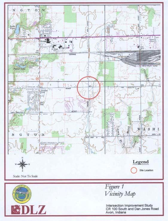
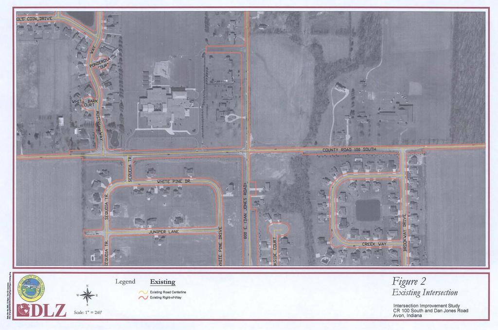
4 SECTION I: BACKGROUND INFORMATION PURPOSE OF STUDY The Hendricks Intersection Improvement Study is sponsored by the Town of Avon, Indiana. This report compares the benefits and costs of two intersection improvement alternatives with the benefits and costs of retaining the existing intersection without any improvements. The two improvement alternatives that were evaluated are a reconstructed traffic signal alternative and a modern roundabout alternative. PROJECT AREA The project is located within the Town of Avon in eastern Hendricks County, Indiana (Figure 1). The Town of Avon was incorporated in November of 1995 and has experienced rapid population growth over the past 10 years. A major cause of this growth has been the expansion of the Indianapolis metropolitan area, which has brought significant residential and commercial growth to Avon. The resulting traffic demands have caused extensive delay and congestion on roads like Dan Jones Rd. and C.R. 100 S., which were designed as rural roads. Both Dan Jones Rd. and C.R. 100 S. are important links within the Town of Avon and both are designated as Urban Minor Arterials within the Avon Thoroughfare Plan. Dan Jones Rd. is a primary north/south route through Avon, with a bridge over the east/west CSX rail line approximately 3500 feet north of the study intersection. Dan Jones Rd. is a two-lane roadway with one travel lane in each direction, 2-foot gravel shoulders and open drainage in the project vicinity. An entrance to the CSX Transportation Avon rail yard is also located on Dan Jones Rd., immediately south of the railroad overpass. C.R. 100 S. is an east/west road that serves as an alternate route to the congested U.S. 36 (Rockville Road) for traffic commuting to and from Indianapolis. C.R. 100 S. is a two-lane roadway with one travel lane in each direction, 2-foot gravel shoulders and open drainage in the project vicinity. There are no sidewalks along either road. The intersection of the two roads is currently controlled by a traffic signal, with no auxiliary turn lanes on any approach. Land use in the project area is a mixture of residential and agricultural. The northeast corner of the intersection is being used as cropland, a residential development exists on the southwest corner, and the parcels on the northwest and southeast corners are currently vacant. Pine Creek Elementary school is just northwest of the intersection. There are two school entrance drives on C.R. 100 S., approximately 375 feet and 940 feet west of Dan Jones Rd. There is also one school entrance drive on Dan Jones Rd., approximately 790 feet north of C.R. 100 S. Clark s Creek flows generally north/south through the project area and crosses under C.R. 100 S. approximately 440 feet east of the Dan Jones Rd. intersection. The C.R. 100 S. bridge over Clark s Creek (Hendricks County Bridge 241) was constructed in It is a concrete box beam bridge with a span of 24 feet and a width of 36 feet. Intersection Improvement Study 1 November
5 EXISTING AND PROJECTED TRAFFIC Existing (year 2003) traffic counts for the intersection of C.R. 100 S. and Dan Jones Rd. were provided by the Town of Avon. The data included morning and afternoon peak hour traffic volumes for each individual turning movement (e.g., through movement, left turn, right turn) at the intersection. The Morning peak hour is from 7:00 to 8:00 a.m., and the afternoon peak hour is from 5:00 to 6:00 p.m. Projected Year 2025 morning and afternoon peak hour traffic volumes were developed for the intersection. These projections were based on information obtained from the Avon Thoroughfare Plan, the Indianapolis Metropolitan Planning Organization, and a recent traffic impact study for the Wellington residential development, which is proposed to be located south of C.R. 100 S. and east of Dan Jones Rd peak hour volume forecasts were used from the Wellington traffic impact study peak hour volume forecasts were then developed based on an assumed annual traffic volume growth rate of 0.5 percent from 2007 to Unadjusted output from the Indianapolis Metropolitan Planning Organization travel demand model showed an annual growth rate of 0.32 percent for average daily traffic volumes between 2006 and Table 1 shows the existing and forecast AM and PM peak hour turning movement volumes for the intersection. Table 1: Existing and Projected Intersection Traffic Volumes AM Peak Hour Eastbound Westbound Northbound Southbound Total (7-8 a.m.) L T R L T R L T R L T R 2003 Existing Forecast Forecast PM Peak Hour Eastbound Westbound Northbound Southbound Total (5-6 p.m.) L T R L T R L T R L T R 2003 Existing Forecast Forecast existing counts collected by Traffic Engineering, Inc. on February 19, Forecast from transportation impact study for Crossman Communities Wellington Development, Edwards & Kelcey, July Forecast based on assumed 0.5% annual growth in traffic from 2007 to The Synchro 5 software package was used to determine the Highway Capacity Levels of Service (LOS) for the intersection during the morning and afternoon peak hours using the methods of the Transportation Research Board Highway Capacity Manual, 2000 Edition. The LOS is a quantitative measure that describes the quality of operating conditions within the traffic stream and the perception of motorists. The LOS of an intersection is based on the total delay experienced by vehicles waiting to travel through the intersection. The LOS is based on a scale of A to F, with A being the best situation. A study of this intersection conducted in 2000 indicated that it operated at an LOS B during both the morning and afternoon peak hours. Existing signal timing data could not be obtained from the Town in Intersection Improvement Study 2 November
6 order to verify this LOS. However, significant queuing was observed at the intersection on various occasions during the Summer of 2003, which indicates that the current LOS may actually be lower than B. A peak hour LOS D is typically considered the minimum acceptable operating condition at an intersection Table 2 describes the specific LOS criteria for signalized intersections. Detailed Synchro software output is provided in Appendix A. Table 2. Level of Service Criteria For Signalized Intersections LOS Average Delay (Seconds/Vehicle) Description A < 10 Most vehicles do not stop at all B > 10 and < 20 More vehicles stop than for LOS A C > 20 and < 35 The number of vehicles stopping is significant, although many pass through without stopping D > 35 and < 55 Many vehicles stop. Individual cycle failures are noticeable E > 55 and < 80 Considered being the limit of acceptable delay. Individual cycle failures are frequent F > 80 Unacceptable delay Source: Transportation Research Board, Highway Capacity Manual, 2000 Intersection Improvement Study 3 November
7 SECTION II: ALTERNATIVES This section describes the three alternatives considered as part of this study and presents the results of the analysis performed for these alternatives. A comparative matrix has also been included at the end of this section to highlight the major differences among the alternatives. NO-BUILD ALTERNATIVE The No Build Alternative is intended to represent baseline conditions against which the benefits and impacts of the other alternatives can be compared. The No Build Alternative includes no improvements to the existing intersection. However, traffic volumes are anticipated to increase in the project area between now and 2025 as identified in Section I. The No Build Alternative is the existing signal-controlled intersection with year 2025 traffic volumes. Right-of-Way No additional ROW would be required for the No Build Alternative. Traffic Operations Traffic operations for the No Build Alternative were analyzed using the year 2025 peak hour traffic volumes from Table 1. With optimized signal timing but no geometric improvements, the No Build Alternative would provide an AM peak hour LOS of F. In addition, northbound, eastbound and southbound traffic volumes would exceed the capacity of those approaches by a significant amount. This means that vehicle queues and delays would continue to grow over the peak hour. During the PM peak hour, this alternative would also have an LOS of F, with volumes greatly exceeding capacity on all approaches. Appendix A includes the Synchro output data files for this traffic signal analysis. Cost There is no direct construction cost associated with the No Build Alternative, as the No Build Alternative does not include improvements to the intersection. However, the cost attributable to lost time due to delays and other indirect costs are substantial and will increase as conditions worsen. The annual operating cost of the no build alternative was estimated to be $1,690. This would include costs for periodic routine maintenance for the traffic signal, signs and pavement markings, as well as trouble calls for malfunctioning signal equipment. Operational costs also include the cost of electricity for the traffic signal. A breakdown of these costs is included in Appendix C. The annual operating costs for the no build alternative traffic signal do not include the cost for replacement of the traffic signal hardware, which would be necessary approximately 15 years after their initial installation. Additional Auto Capacity This alternative does not have additional auto capacity because it is already predicted to operate at LOS F. Intersection Improvement Study 4 November
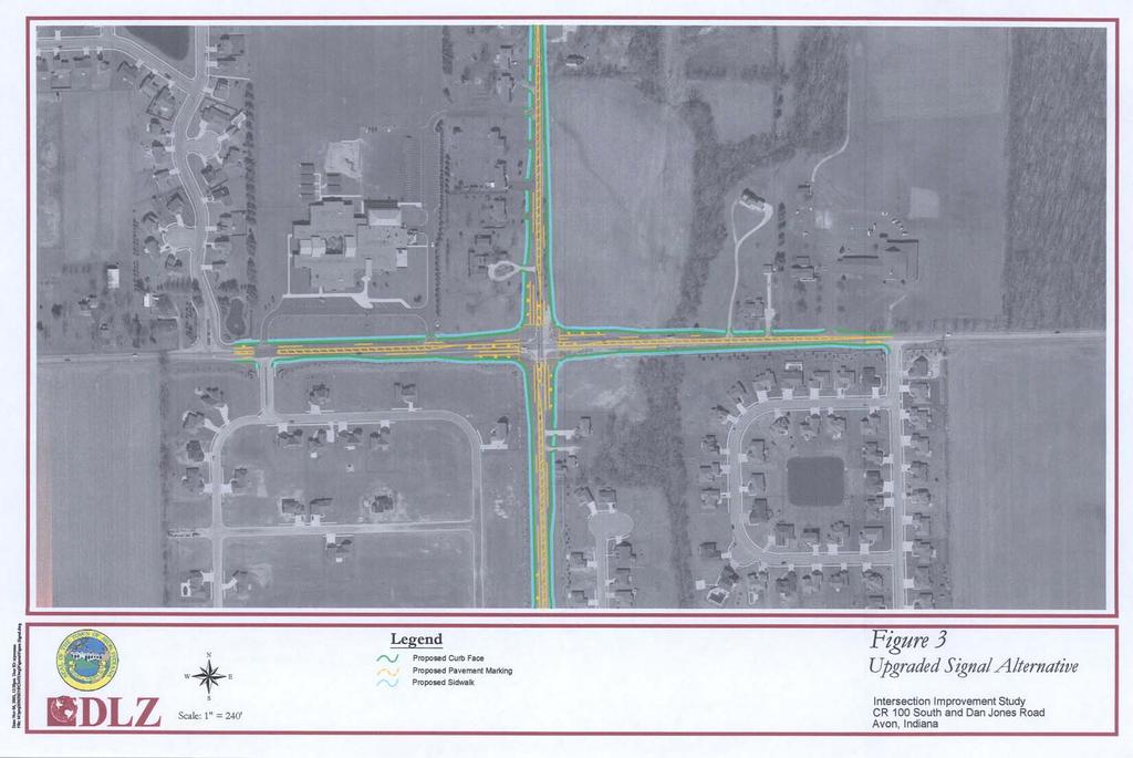
8 Accommodation of Driveway Access The existing driveway configuration would be maintained. All driveways are reasonably accommodated under the No Build Alternative. Bicycles and Pedestrians The existing intersection has no separate bicycle or pedestrian accommodations. Pedestrians would continue to use the roadway shoulders or grass right-of-way. Cyclists would continue to use the roadway travel lanes. Pedestrian and bicycle traffic is currently low, but safety could become more of a concern as residential development continues in the vicinity and as traffic congestion increases. Safety The No Build Alternative would not provide any safety improvements for the project area. Intersection crashes are likely to increase and safety is likely to decrease as traffic volumes and congestion at the intersection increase. Aesthetics The No Build Alternative would not have any scenic impacts, but it would also not provide new opportunities for aesthetic enhancements. RECONSTRUCTED TRAFFIC SIGNAL ALTERNATIVE The Synchro traffic modeling software was used to determine the required geometric and traffic operational characteristics of a reconstructed traffic signal alternative that would accommodate the year 2025 peak hour volumes with an acceptable peak hour LOS. Geometry To accommodate the projected 2025 volumes with acceptable peak hour LOS would require reconstructing the intersection to provide two through lanes plus left and right turn lanes on all approaches. Figure 3 shows the configuration of this reconstructed traffic signal alternative. This alternative was developed based on a design speed of 45 mph (posted speed is 40 mph) on both roads. The design vehicle was a WB-62 truck (18-wheel Interstate tractor trailer), and it was assumed that about two percent of vehicles would be trucks. It was assumed that the reconstructed roadway would have a curb and gutter drainage system, as called for in the typical urban arterial section in the Avon Thoroughfare Plan. This would minimize ROW acquisition and impacts associated with roadside ditches. Due to the extent of roadway widening necessary, this alternative would require the replacement or widening of the existing C.R. 100 S. bridge over Clark s Creek. In addition, the existing sanitary lift station on the northeast corner of the intersection would need to be relocated to accommodate the roadway widening. Auxiliary turn lane lengths at the reconstructed intersection were determined using the procedures of Section (02) of the Indiana Department of Transportation Design Manual. Auxiliary through lane lengths were determined using the procedures of Section of the Indiana Department of Transportation Design Manual. When widening a two-lane road to accommodate additional through lanes at an intersection, long transition distances are typically required both upstream and downstream of the intersection. These transition distances are required (1) to ensure safe and efficient merging of traffic into a single lane downstream of the intersection and (2) to encourage full use of both through lanes by traffic. Intersection Improvement Study 5 November
9 The usage of additional through lanes that are only provided for short distances at intersections is typically very low, resulting in the loss of much of the intersection capacity. Many drivers are reluctant to use short auxiliary through lanes because they know they will have to immediately merge back into the primary travel lane and will be perceived as cutting in the queue. Right-of-Way ROW would need to be acquired in order to reconstruct the traffic signal. ROW is required for the expanded intersection including turn lanes and lane tapers. A total of approximately 124,600 square feet (2.86 acres) of permanent ROW would need to be acquired to construct this alternative. One home in the southeast quadrant would need to be acquired for this alternative. In addition, the existing sanitary lift station on the northeast corner would require relocation. The existing earth berm on the southwest corner is likely to be impacted significantly as it runs along C.R. 100 S. The ROW requirements would need to be refined during project design. Traffic Operations Using the year 2025 peak hour traffic volumes from Table 1, traffic operations for the intersection were analyzed. With optimized signal timing, the reconstructed traffic signal alternative would provide an AM peak hour LOS of B with an average of 16.7 seconds of delay per vehicle. During the PM peak hour, this alternative would have LOS B with an average of 19.5 seconds of delay per vehicle. Appendix A includes the Synchro output data files for the traffic signal analysis. Cost The cost of the reconstructed traffic signal alternative is estimated to be approximately $3.40 million (year 2003 dollars). This would include design and construction of all road improvements shown in Figure 3, replacement of the C.R. 100 S. bridge over Clark s Creek, relocation of the sanitary lift station, adding a traffic signal and lighting, ROW acquisition, drainage improvements, landscaping, and sidewalk. Actual costs could change as the project is designed. A more detailed breakdown of this cost estimate is included in Appendix C. The annual operating cost of the reconstructed traffic signal was estimated to be $2,290. This would include costs for periodic routine maintenance for the traffic signals, signs and pavement markings, as well as trouble calls for malfunctioning signal equipment. Operational costs also include the cost of electricity for the traffic signals and lighting. A breakdown of these costs is included in Appendix C. The annual operating costs for the reconstructed traffic signal do not include the cost for replacement of the traffic signal hardware, which would be necessary after approximately 15 years. Additional Auto Capacity The reserve capacity of this alternative was calculated at 27 percent. This means that peak hour traffic volumes at the intersection could increase by approximately 27 percent beyond the 2025 AM peak hour traffic projections in Table 1 before the intersection would reach LOS E or approach volumes would exceed capacity. Accommodation of Driveway Access All driveways near the intersection would be reasonably accommodated by this alternative. Impacted drives would be reconstructed to meet INDOT standards, but no drives would Intersection Improvement Study 6 November
10 require relocation. If a new driveway were constructed to access Dan Jones Rd. from the parcel on the northwest corner of the intersection, this driveway would need to allow right-in, right-out access only because of its proximity to the intersection Bicyclists and Pedestrians New sidewalks along C.R. 100 S. and Dan Jones Rd. would be incorporated into the reconstructed traffic signal alternative (Figure 3). Pedestrian crosswalks and curb ramps would be provided at the intersection. The traffic signal would include pedestrian signal indications and pushbuttons. Bicycles would be accommodated in the vehicle traffic lanes. Safety This alternative would improve safety in the project area relative to what would be experienced without improvements at the intersection. However, crashes would likely still increase as traffic volumes at the intersection continue to increase. Aesthetics The traffic signal alternative would result in scenic impacts to the corridor as a result of widening the intersection with additional asphalt surface. Installation of sidewalk, curb and gutter, decorative lighting, and decorative mast arm signal poles would reflect the growing suburban character of the vicinity. Relocation of the existing sanitary lift station would also provide an aesthetic enhancement. MODERN ROUNDABOUT ALTERNATIVE An analysis of the intersection was performed using the roundabout modeling software RODEL for the year 2025 peak hour volumes to determine the required geometric characteristics for a modern roundabout. This information was used to prepare a conceptual roundabout design for the intersection. This concept balances a number of important factors including traffic operations, safety, ROW acquisition, and cost. Geometry Modern roundabout geometry is influenced by a variety of factors related to traffic operations and safety considerations. Roundabout geometry is used to control the speed at which motorists can enter and exit an intersection. There are two speed regimes considered when designing a roundabout: (1) speeds during peak hours when traffic volumes are highest and motorists stay within designated lanes, and (2) speeds during off-peak hours when the occasional motorist ignores lane markings and negotiates the roundabout at the highest possible rate of speed. After detailed analysis and design work, the modern roundabout proposed for the C.R. 100 S./Dan Jones Rd. intersection was developed. This roundabout is shown in Figure 4, and relevant geometric parameters are summarized in Table 3. The proposed design (Figure 4) includes a roundabout with two-lane entries on both Dan Jones Rd. approaches and the eastbound C.R. 100 S. approach, and a two-lane entry with a right turn bypass lane on the westbound C.R. 100 S. approach. The roundabout was located to the greatest extent practical to minimize ROW impacts, to avoid impacting the berm in the southwest quadrant of the intersection, and to avoid the C.R. 100 S. bridge over Clark s Creek. Preliminary coordination was undertaken regarding the roundabout s location with staff from the Town of Avon to address these constraints. Construction of the roundabout Intersection Improvement Study 7 November
11 would require relocation of the existing sanitary lift station on the northeast corner of the intersection. Table 3. Roundabout Geometry Component Southbound Eastbound Northbound Westbound Entry Width (curb face to curb face)* 26.3 ft 26.3 ft 26.3 ft 26.3 ft Number of Entry Lanes Flare Length 395 ft 395 ft 330 ft 165 ft Inscribed Circle Diameter (ICD) 197 ft 197 ft 197 ft 197 ft Entry Radius 82 ft 82 ft 82 ft 82 ft Entry Angle Half Width 12 ft 12 ft 12 ft 12 ft Number of Exit Lanes *Entry widths include travel lanes and gutters (i.e., they are measured curb face to curb face). All legs of the roundabout include two entering and two exiting lanes. Each leg drops one lane downstream of the roundabout exits to tie into the existing road, which has one lane in each direction (Figure 4). The taper used for these lane drops is appropriate for the speeds at which vehicles will be exiting the roundabout (approx mph). The entry and exit lanes will be divided by a splitter (deflector) island. Splitter islands serve many purposes as they provide shelter for pedestrians, assist in controlling speeds, separate approaching and exiting traffic, guide traffic into the roundabout at the correct angle, and help deflect out-ofcontrol vehicles so that they do not enter the roundabout at a right angle to circulating traffic. Splitter islands are also used to accommodate signs. As in the Reconstructed Signal Alternative, the design vehicle used for the roundabout was a WB-60 (18-wheel tractor trailer). This vehicle can be accommodated on all turning movements at the roundabout. A truck apron about 15 feet wide will be required in the central island to accommodate left turns by this vehicle (Figure 4). It was assumed that all four legs of the roundabout would have a curb and gutter drainage system, as called for in the Thoroughfare Plan. All of the curbs used for the roundabout should be non-mountable except around the central island. The central island curb should be mountable to accommodate large trucks (WB-62) making left turns, but it should be high enough to discourage passenger vehicles (e.g., sport utility vehicles) from driving over it. This assures that motorists will not drive over curbs in an attempt to increase the speed at which they negotiate the intersection. In addition, the non-mountable curb on the splitter islands would help deflect out-of-control vehicles so that they do not enter the roundabout at a right angle to circulating traffic. This lessens the possibility of serious crashes. Right-of-Way In order to construct the modern roundabout alternative, ROW would need to be acquired from properties near the intersection. ROW is required not only for the roundabout, but to construct the approach and exit lanes and tapers. Attempts were made during the concept development to minimize ROW impacts to the greatest extent possible without impacting the operation or safety of the roundabout. A total of approximately 58,800 square feet (1.35 Intersection Improvement Study 8 November
12 acres) of ROW would need to be acquired to construct the roundabout. Most of the roundabout will be located in the northeast quadrant of the existing intersection (Figure 4). This alternative would also require ROW acquisition in the other quadrants as well. It is possible that some of these ROW impacts could be reduced during the design phase if this alternative is selected for construction. No structures would be impacted for the construction of the modern roundabout. However, the existing sanitary lift station on the northeast corner would require relocation. Traffic Operations The RODEL analysis showed that the modern roundabout would provide LOS A in year 2025 for the AM peak hour, with an average delay per vehicle of 8.2 seconds. The year 2025 PM peak period is estimated to have an average delay per vehicle of approximately 7.3 seconds, which is also LOS A. This analysis was developed for the 50 percent confidence level for capacity (i.e., the capacity that is most likely to occur at the intersection). The roundabout alternative was also tested at the 85 percent confidence level (i.e., a pessimistic capacity), and this test showed that the roundabout would still provide acceptable traffic operations for this scenario in 2025 (LOS B with average delay of 14.2 seconds for the PM peak hour and LOS B with average delay of 17.1 seconds in the AM peak hour). RODEL output summary sheets are included in Appendix B. As a type of unsignalized intersection, the LOS criteria used for modern roundabouts are similar to those used for signalized intersections, except slightly more strict. Table 2 shows the LOS thresholds for all types of unsignalized intersections. Cost The estimated cost of the modern roundabout alternative is approximately $2.20 (year 2003 dollars). This would include design and construction of all road improvements shown in Figure 4, ROW acquisition, lighting, drainage improvements, landscaping, and sidewalks. All costs have been estimated conservatively. The actual cost of this alternative may change once a more detailed investigation is performed during the design phase, especially with regard to the vertical curve to the north of the intersection. A more detailed cost breakdown is included in Appendix C. The annual operating costs of the modern roundabout was estimated to be $2,340. These include costs for periodic maintenance (e.g., pavement markings, mowing, and signage) and the cost of electricity for lighting. A breakdown of these costs is also included in Appendix C. Additional Auto Capacity Additional analysis was performed to determine how much excess capacity the proposed roundabout would have. Construction of the modern roundabout would provide about 18 percent reserve auto capacity at the intersection. This means that traffic volumes at the intersection could increase by approximately 18 percent beyond year 2025 AM peak hour volumes before the intersection would reach LOS E. The future addition of right turn bypass lanes on the eastbound and southbound approaches, if needed, would provide the roundabout with about 27 percent reserve capacity beyond the 2025 AM peak hour volumes. Although these bypass lanes would have additional cost and ROW impacts, they could be accommodated by the proposed design if they are ever needed. Intersection Improvement Study 9 November
13 Accommodation of Driveway Access The modern roundabout alternative would reasonably accommodate all driveways. Although this alternative reasonably accommodates existing driveways, it does result in minor changes to residential driveways. If a new driveway were constructed to access Dan Jones Rd. from the parcel on the northwest corner of the intersection, this driveway would need to allow right-in, right-out access only because of its proximity to the intersection. Those wishing to travel north would make a U-turn around the roundabout. Full-access drives could be allowed at all other locations. Bicyclists and Pedestrians New sidewalks along C.R. 100 S. and Dan Jones Rd. would be incorporated into the modern roundabout alternative (Figure 4). It is recommended that bicycles should not circulate within a roundabout. Instead, they should use pedestrian crossings at the roundabout. As long as bicyclists avoid circulating inside the roundabout, they would be safely accommodated by this alternative. Modern roundabout intersections accommodate pedestrians safely. However, it should be noted that in parts of the U.S., some visually impaired pedestrians have stated that they are concerned about their ability to safely cross at modern roundabout intersections with heavy traffic volumes and relatively slow speeds. Therefore, some blind pedestrians may have difficulties crossing independently at modern roundabout intersections. Safety Properly designed modern roundabouts are very safe, and crashes would likely be reduced relative to what would occur without improvements to the intersection or with the traffic signal alternative. Due to their low circulating speeds, deflection at entry, and yield-controlled entrances, modern roundabouts are substantially safer than intersections controlled by traffic signals, traffic circles, and stop signs. Studies from around the world have found that modern roundabouts typically reduce crashes by 40 to 60 percent compared to stop signs and traffic signals. They also typically reduce injury crashes by 35 to 80 percent and almost completely eliminate incapacitating injury and fatal crashes. A comprehensive recent U.S. study (Insurance Institute for Highway Safety 2000) is consistent with these results. Aesthetics The modern roundabout alternative would provide opportunities for aesthetic enhancement. These opportunities would come from the green space in the splitter islands and the central island. A conceptual rendering of the modern roundabout alternative is shown in Figure 5. The drawing shows how this alternative could be landscaped to improve the aesthetics of the intersection. Roundabouts are often used as gateway improvements for communities. In these instances, the central island of the roundabout can contain a variety of features to enhance the roadway. Future Considerations The roundabout alternative has been designed so that future widening of C.R. 100 S. or Dan Jones Rd. could be accommodated without changes to the intersection. While the approaches and exits would need to be altered to tie into the roundabout, changes would not be needed inside the splitter islands. If and when these roads are ever widened, care should be taken to assure that the road designs do not negatively affect the roundabout s traffic operations or safety. This would entail an analysis and design by persons knowledgeable Intersection Improvement Study 10 November
14 about roundabouts. This is especially important relative to speed control and capacity on the approaches. In addition to these considerations, if traffic volumes increase beyond those expected or capacities are lower than those predicted, right turn bypass lanes could be added on the eastbound and southbound approaches to provide improved traffic operations. Although these bypass lanes would have additional cost and ROW impacts, they could be accommodated by the proposed design if they are ever needed. Intersection Improvement Study 11 November
15 SECTION III COMPARISON OF ALTERNATIVES In order to compare the alternatives, several criteria were considered. All of the criteria are directly related to benefits and impacts of the alternatives and are quantified where possible. Table 4 includes a summary of the results of this comparison. Right-of-Way ROW will be required for both of the build alternatives (i.e., the reconstructed traffic signal alternative and the modern roundabout alternative). Approximately 2.86 acres of ROW are needed for the reconstructed signal alternative, and 1.35 acres are needed for the modern roundabout. The reconstructed traffic signal alternative would also require acquisition of a home in the southeast quadrant of the intersection. Both alternatives would require relocation of the existing sanitary lift station on the northeast corner of the intersection. It is anticipated that the signal alternative would have a significant impact on the existing earth berm on the southwest corner of the intersection but the roundabout alternative would have only a minor impact on this berm. Traffic Operations The traffic operations of the two build alternatives for the year 2025 peak hour volumes are both acceptable (LOS D or better). However, the LOS of the modern roundabout (LOS A) is better than the reconstructed traffic signal alternative (LOS B), and it has a lower average vehicle delay. Even with pessimistic assumptions of driver behavior at the roundabout, its traffic operation is still better than the traffic signal. Cost The reconstructed traffic signal alternative would cost about $1.2 more to construct than the roundabout alternative in year 2003 dollars ($3.40 million vs. $2.20 million). This difference is mainly due to the length of new road that needs to be constructed for the two alternatives. The reconstructed traffic signal alternative requires longer taper lengths for the additional intersection approach lanes and thus does not tie back into the existing road as quickly as the roundabout alternative. The reconstructed traffic signal alternative therefore requires more new roadway than the roundabout alternative. Because of this, the reconstructed traffic signal alternative would also require that the C.R. 100 S. bridge over Clark s Creek be widened. This difference can be seen in Figures 3 and 4. These planning level cost estimates will need to be further refined and adjusted during the design phase of the project. In addition to construction costs, annual operational cost of the alternatives were estimated. These costs were estimated to be approximately the same for both alternatives ($2,290 for the signal alternative vs. $2,340 for the roundabout alternative)..landscape maintenance and lighting costs would likely be somewhat higher for the roundabout, but these additional costs would be more than offset by the savings in traffic signal maintenance and electricity costs. In addition, the traffic signal hardware would require replacement within approximately 15 years after initial construction. This cost is not included in the annual maintenance cost. Additional Auto Capacity The reconstructed traffic signal alternative provides about 27 percent reserve auto capacity at the intersection, while the modern roundabout provides about 18 percent reserve auto capacity. This means that the traffic signal would have a greater safety buffer for handling traffic beyond the 2025 projections than the roundabout configuration currently proposed. With the addition of right turn bypass lanes for the eastbound and southbound approaches, Intersection Improvement Study 12 November
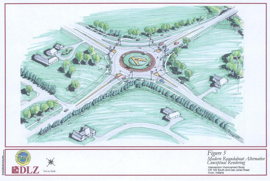
16 the roundabout could also accommodate approximately 27 percent more traffic than the 2025 forecast. This would require additional ROW and construction cost, but would not require significant reconstruction of the roundabout. Accommodation of Driveway Access Both the modern roundabout and traffic signal accommodate all existing driveways around the intersection (Figures 3 and 4). No drives would require relocation under either alternative. Impacted driveway approaches would be reconstructed to meet INDOT standards. Any new drive onto Dan Jones Rd. from the vacant parcel on the northwest corner would need to be right-in, right-out under the either the alternative, but U-turns can be accomplished easily with the roundabout. Pedestrians and Bicyclists The modern roundabout alternative would accommodate pedestrian crossings more safely than the traffic signal alternative. Studies have found that pedestrian-related crashes are reduced by 30 to 40 percent (relative to other types of intersection control) and are much less serious at modern roundabouts. This is due to lower travel speeds and the fact that pedestrians need only cross one direction of traffic at a time, using splitter islands as a refuge. However, it should be noted that in parts of the U.S., some blind pedestrians have stated that they are concerned about their ability to safely cross at modern roundabout intersections with heavy traffic volumes and relatively slow speeds. Therefore, some visually impaired pedestrians may have difficulties crossing independently at modern roundabout intersections. The two build alternatives would have similar operations for bicycles as long as they avoid circulating within the roundabout. Safety The roundabout would result in about half the injury crashes that would be experienced with a traffic signal. Properly designed modern roundabouts are substantially safer than traffic signals due to their low circulating speeds, reduced number of conflict points, and deflection at entry. Generally, converting from a four-leg signalized intersection to a four-leg modern roundabout will reduce the number of conflict points from 32 (traffic signal) to eight (modern roundabout). Converting to a modern roundabout will also reduce the speed of vehicles entering the intersection. This will reduce the potential for high speed crashes and injury crashes at the intersection. Studies have clearly demonstrated that properly designed modern roundabouts typically reduce total crashes by 40 to 60 percent compared to stop signs and traffic signals. They also typically reduce injury crashes by 35 to 80 percent and almost completely eliminate incapacitating injury and fatal crashes (Insurance Institute for Highway Safety, 2000). Based on this information, the modern roundabout alternative will have the best safety performance out of the three alternatives. Aesthetics The modern roundabout alternative provides a better opportunity for aesthetic enhancements, as landscaping and other amenities can be placed within the central island and splitter islands where they do not interfere with required lines of sight. The exact locations where landscaping is allowable would be determined during the design phase of the project. Intersection Improvement Study 13 November
17 Table 4. Alternative Evaluation Matrix (for year 2025) Evaluation Criteria Comments No Build Reconstructed Traffic Signal Modern Roundabout Amount of new ROW and 2.86 Acres 1.35 Acres Right-of-Way/Relocations required relocations required to construct None 1 home and sanitary lift station sanitary lift station the alternative. Future Traffic Operations (2025) Planning-Level Construction Cost Estimate Operational Costs Additional Auto Capacity Accommodation of Driveway Access Bicyclists and Pedestrians Safety Aesthetics Average delay per vehicle and LOS for AM and PM peak hours for the year Includes cost for design, construction, construction inspection, and ROW acquisition. All costs are in year 2003 dollars. Approximate cost of ongoing operations including electricity (lighting), signal adjustment, bulbs/other equipment, mowing, pavement markings, etc. Amount (%) that year 2025 peak hour auto traffic could increase before the intersection would reach LOS E. Assumes a proportional increase of all entering volumes simultaneously. Rating of how well the proposed intersection will accommodate existing driveway access. Rating of the mobility, safety, and impacts on bicyclists and pedestrians of the proposed intersections. Based on recent U.S. studies. Potential impacts to the scenic qualities near the intersection and opportunities for aesthetic enhancements. Demand Exceeds Capacity LOS = F AM Delay = 16.7 sec / LOS = B PM Delay = 19.5 sec / LOS = B AM Delay = 8.2 sec / LOS = A PM Delay = 7.3 sec / LOS = A Daily savings of >20 vehicle-hours of delay by 2025 compared to reconstructed traffic signal. $0 $3.40 Million $2.20 Million Approximately $1,690 per year Approximately $2,290 per year Approximately $2,340 per year No change to driveways. No changes to pedestrian or bicycle facilities. n/a 27% Slight increase in crashes relative to existing condition as congestion and volumes increase. No impacts to existing scenic qualities. Moderate opportunity for aesthetic enhancement. All driveways reasonably accommodated. Possible minor impacts to some new driveways. Pedestrians and bicyclists safely accommodated. Lower crash rate than no build due to signal, lane and lighting improvements. Significantly higher crash rate and severity than roundabout. Moderate scenic impacts from increased pavement area. Limited opportunities for aesthetic enhancements in remaining ROW. 18% with initial configuration. 27% with added bypass lanes. All driveways reasonably accommodated. Possible minor impacts to some new driveways. Pedestrians safely accommodated; Bikes safely accommodated as long as they do not use circulating roadway. Minor concerns related to visually impaired pedestrians. Up to 60% fewer total crashes, 80% fewer injury crashes, and 90% fewer fatalities than reconstructed signal intersection. Minor scenic impacts. Several aesthetic opportunities will result from the construction: addition of green space and the opportunity for increased landscaping. Intersection Improvement Study 14 November 7, 2003
18 SECTION IV: RECOMMENDATION Upon reviewing the impacts and benefits of the three alternatives considered, DLZ recommends the modern roundabout alternative as the best long-term solution at this location. This recommendation is based on the following key distinctions: The roundabout would provide better traffic operation, with less than half of the peak hour intersection delay of the reconstructed traffic signal. The roundabout would provide a safer intersection, with up to 60% fewer crashes and up to 80% fewer injury crashes than the reconstructed traffic signal. The roundabout would cost approximately $1.2 million less to construct than the reconstructed traffic signal. The roundabout would require less than half of the new ROW that the reconstructed traffic signal would require and would not require purchase of a home. The roundabout alternative would have lower impacts to scenic qualities and would provide more opportunities for aesthetic enhancements than the reconstructed traffic signal alternative. If the roundabout alternative is advanced into the design phase, a few important issues will need to be evaluated. First, proposed landscaping treatments should be developed in a way that does not interfere with required sight distances. Second, driveway access details will need to be worked out with property owners. Finally, vertical stopping sight distances on the intersection approaches will need to be verified to assure they are adequate. Intersection Improvement Study 15 November 7, 2003
19 SECTION V: REFERENCES American Association of State Highway and Transportation Officials A Policy on Geometric Design of Highways and Streets. Washington, D.C. Edwards & Kelcey. July Wellington Traffic Impact Study. Prepared for Crossman Communities. Insurance Institute for Highway Safety Crash Reductions Following Installation of Roundabouts in the United States. Arlington, VA. The Schneider Corporation. July 14, 1999 (revision). Avon Thoroughfare Plan. Transportation Research Board Highway Capacity Manual. Washington, D.C. Federal Highway Administration. Washington, D.C. No Date. Your community deserves a lot less Intersection Improvement Study 16 November 7, 2003
20 Appendix A - Synchro Outputs for Year 2025 Traffic Signal Alternative
21
22
23
24
25 Appendix B RODEL Outputs
26 RODEL Output for Year 2025 AM Peak Hour ******************************************************************************** * * * 18:8: AVON INDIANA 2 LANER 1 BYPASS 50p AM PEAK 7539 * * * ******************************************************************************** * * * * E m * TIME PERIOD min 90 * * L' m * TIME SLICE min 15 * * V m * RESULT PERIOD min * * RAD m * TIME COST pnd/hr 1.00 * * PHI d * FLOW PERIOD min * * DIA m * RULE left/right RIGHT * * G. SEP * CONFID. LEVEL % 50 * * * * ******************************************************************************** * NAME *PCU * FLOWS (1st exit 2nd etc..u) *FLOF*CAPF* FLOW RATIO *FLO TIME* * * * * * * * * *SB DJONE*1.05* *1.00*1.00* * * *EB CR100*1.05* *1.00*1.00* * * *NB DJONE*1.05* *1.00*1.00* * * *WBCR100 *1.05* *1.00*1.00* * * * * * * * * * * * * * * * * * * * * * * * * * * ******************************************************************************** * * * * FLOW v * GLOBAL DELAYS * * CAPACITY v * * * DELAY Lane1 s * VEH HRS 7.5 * * DELAY Lane2 s * * * DELAY Lane3 s * AVE DEL 8.2 secs * * DELAY Lane4 s * * * MAX LANE Q v * * * * * ********************************************************************************
27 RODEL Output for Year 2025 PM Peak Hour ******************************************************************************** * * * 18:8: AVON INDIANA 2 LANER 1 BYPASS 50p PM PEAK 7540 * * * ******************************************************************************** * * * * E m * TIME PERIOD min 90 * * L' m * TIME SLICE min 15 * * V m * RESULT PERIOD min * * RAD m * TIME COST pnd/hr 1.00 * * PHI d * FLOW PERIOD min * * DIA m * RULE left/right RIGHT * * G. SEP * CONFID. LEVEL % 50 * * * * ******************************************************************************** * NAME *PCU * FLOWS (1st exit 2nd etc..u) *FLOF*CAPF* FLOW RATIO *FLO TIME* * * * * * * * * *SB DJONE*1.05* *1.00*1.00* * * *EB CR100*1.05* *1.00*1.00* * * *NB DJONE*1.05* *1.00*1.00* * * *WBCR100 *1.05* *1.00*1.00* * * * * * * * * * * * * * * * * * * * * * * * * * * ******************************************************************************** * * * * FLOW v * GLOBAL DELAYS * * CAPACITY v * * * DELAY Lane1 s * VEH HRS 8.0 * * DELAY Lane2 s * * * DELAY Lane3 s * AVE DEL 7.3 secs * * DELAY Lane4 s * * * MAX LANE Q v * * * * * ********************************************************************************
28 Appendix C Estimate of Probable Design, Construction and Operation Costs
29 Intersection Improvement Study Summary of Estimated Construction Costs Cost Item Reconstructed Signal Roundabout Roadway Improvements $ 1,168,200 $ 779,600 Sidewalk & Curb Ramp $ 116,700 $ 92,000 Traffic Signal $ 75,000 $ - Traffic Signs, Marking & Lighting $ 36,600 $ 52,000 Sodding & Landscaping $ 25,800 $ 46,600 Drainage $ 218,200 $ 137,800 Relocate Sanitary Lift Station $ 150,000 $ 150,000 Replace Bridge over Clark's Creek $ 282,000 $ - Subtotal $ 2,072,500 $ 1,258,000 Contingency (15%) $ 310,900 $ 188,700 Total Construction Cost $ 2,383,400 $ 1,446,700 Construction Inspection $ 357,500 $ 217,000 Right-of-Way $ 397,700 $ 289,300 Design $ 259,900 $ 246,300 Total Project Cost $ 3,398,500 $ 2,199,300
30 Intersection Improvement Study Summary of Estimated Routine Annual Costs Cost Item No Build Reconstructed Signal Roundabout Electricity Signal 1 $ 740 $ 240 $ - Lighting 2 $ - $ 340 $ 440 Maintenance Signal 3 $ 890 $ 890 $ - Road & Signs 4 $ 60 $ 100 $ 100 Landscaping 4 $ - $ 720 $ 1,800 Total Annual Cost $ 1,690 $ 2,290 $ 2,340 1 Based on electricity at $0.63 per watt per year, the rate paid by the City of Indianapolis. 2 Based on watt lights for signal or watt lights for roundabout. Annual electric rates were estimated using rates paid by the City of Indianapolis. 3 Based on current signal maintenance rate of $74 per month. 4 Costs estimated by DLZ. Reconstructed Traffic Signal Wattage Calculation (Assumes all signal heads are LED) Item Number Wattage per Item Total Wattage 3-section head section head pedestrian head cabinet Total 385 Existing Trafffic Signal Wattage Calculation (Assumes all signal heads are incandescent) Item Number Wattage per Item Total Wattage 3-section head cabinet Total 1180
31
32
33
34
35
133 rd Street and 132 nd /Hemlock Street 132 nd Street and Foster Street MINI ROUNDABOUTS. Overland Park, Kansas
 133 rd Street and 132 nd /Hemlock Street 132 nd Street and Foster Street MINI ROUNDABOUTS Overland Park, Kansas September 1, 2017 TABLE OF CONTENTS 1. INTRODUCTION... 1 2. LITERATURE REVIEW... 1 3. CONCEPT
Figure 1: Vicinity Map of the Study Area
 ARIZONA TEXAS NEW MEXICO OKLAHOMA May 5, 2016 Mr. Anthony Beach, P.E. BSP Engineers 4800 Lakewood Drive, Suite 4 Waco, Texas 76710 Re: Intersection and Access Analysis along Business 190 in Copperas Cove
5858 N COLLEGE, LLC N College Avenue Traffic Impact Study
 5858 N COLLEGE, LLC nue Traffic Impact Study August 22, 2016 Contents Traffic Impact Study Page Preparer Qualifications... 1 Introduction... 2 Existing Roadway Conditions... 5 Existing Traffic Conditions...
INDUSTRIAL BUILDING 3009 HAWTHORNE ROAD CITY OF OTTAWA TRANSPORTATION OVERVIEW REVISED. Prepared for: Canada Inc.
 INDUSTRIAL BUILDING 3009 HAWTHORNE ROAD CITY OF OTTAWA TRANSPORTATION OVERVIEW REVISED Prepared for: 7849648 Canada Inc. Octiober 1, 2015 114-598 Overview_2.doc D. J. Halpenny & Associates Ltd. Consulting
METHODOLOGY. Signalized Intersection Average Control Delay (sec/veh)
") Chapter 5 Traffic Analysis 5.1 SUMMARY US /West 6 th Street assumes a unique role in the Lawrence Douglas County transportation system. This principal arterial street currently conveys commuter traffic
Chapter 5 Traffic Analysis 5.1 SUMMARY US /West 6 th Street assumes a unique role in the Lawrence Douglas County transportation system. This principal arterial street currently conveys commuter traffic
ALLEY 24 TRAFFIC STUDY
 ALLEY 24 TRAFFIC STUDY in City of Frostburg, Maryland January 2013 3566 Teays Valley Road Hurricane, WV Office: (304) 397-5508 www.denniscorporation.com Alley 24 Traffic Study January 2013 Frostburg, Maryland
Public Information Meeting. Orange Camp Road. Dr. Martin Luther King Jr. Beltway to I-4. Presented by: Volusia County August 2, 2018
 Public Information Meeting Orange Camp Road Dr. Martin Luther King Jr. Beltway to I-4 Presented by: Volusia County August 2, 2018 1 Project Goals To improve the operations and safety for Orange Camp Road
INDUSTRIAL BUILDING 1660 COMSTOCK ROAD CITY OF OTTAWA TRANSPORTATION OVERVIEW. Prepared for:
 INDUSTRIAL BUILDING 1660 COMSTOCK ROAD CITY OF OTTAWA TRANSPORTATION OVERVIEW Prepared for: Simluc Contractors Limited 2550 Blackwell Street, Ottawa K1B 5R1 October 18, 2013 113-584 Overview_1.doc D. J.
Traffic Impact Analysis Chatham County Grocery Chatham County, NC
 Chatham County Grocery Chatham County, NC TABLE OF CONTENTS 1. INTRODUCTION... 1 1.1. Location and Study Area... 1 1.2. Proposed Land Use and Access... 2 1.3. Adjacent Land Uses... 2 1.4. Existing ways...
Project Report. South Kirkwood Road Traffic Study. Meadows Place, TX October 9, 2015
 Meadows Place, TX October 9, 2015 Contents 1 Introduction... 1 2 Data Collection... 1 3 Existing Roadway Network... 2 4 Traffic Volume Development... 2 5 Warrant Analysis... 3 6 Traffic Control Alternative
ROUNDABOUTS/TRAFFIC CIRCLES
 GENERAL 1. Description This standard identifies minimum requirements that shall be met for Roundabouts and Neighborhood Traffic Circles in the design and construction of elements for Arlington County Horizontal
TRANSPORTATION ANALYSIS REPORT US Route 6 Huron, Erie County, Ohio
 TRANSPORTATION ANALYSIS REPORT US Route 6 Huron, Erie County, Ohio December 12, 2012 Prepared for: The City of Huron 417 Main Huron, OH 44839 Providing Practical Experience Technical Excellence and Client
Traffic Impact Study WestBranch Residential Development Davidson, NC March 2016
 Traffic Impact Study WestBranch Residential Development Davidson, NC March 216 TRAFFIC IMPACT STUDY FOR THE WestBranch Residential Development LOCATED IN DAVIDSON, NC Prepared For: Lennar Carolinas, LLC
Glenn Avenue Corridor Traffic Operational Evaluation
 Glenn Avenue Corridor Traffic Operational Evaluation PREPARED FOR: THE CITY OF AUBURN PREPARED BY: DECEMBER 2007 Glenn Avenue Corridor Study--Auburn, Alabama TABLE OF CONTENTS Introduction... 1 Background
Intersection Traffic Control Feasibility Study
 Intersection Traffic Control Feasibility Study CSAH 9 at CSAH 60 (185th Avenue) Prepared For: Dakota County Transportation Department Western Service Center 14955 Galaxie Avenue, 3rd Floor Apple Valley,
ROUNDABOUTS. Improving Safety and Efficiency. SR83 & Smithville Western Rd. Joel Montgomery, PE Director of Administration
 ROUNDABOUTS Improving Safety and Efficiency SR83 & Smithville Western Rd. Joel Montgomery, PE Director of Administration The Ohio Department of Transportation District 3 906 North Clark Ave. Ashland, OH
HENDERSON DEVELOPMENT 213, 217, 221, 221 ½, 223 HENDERSON AVENUE and 65 TEMPLETON STREET OTTAWA, ONTARIO TRANSPORTATION OVERVIEW.
 HENDERSON DEVELOPMENT 213, 217, 221, 221 ½, 223 HENDERSON AVENUE and 65 TEMPLETON STREET OTTAWA, ONTARIO TRANSPORTATION OVERVIEW Prepared for: 2294170 Ontario Inc. February 2, 2017 117-652 Report_1.doc
JONESBORO HIGHWAY 63 HIGHWAY 18 CONNECTOR STUDY
 JONESBORO HIGHWAY 63 HIGHWAY 18 CONNECTOR STUDY Craighead County May 2007 JONESBORO HIGHWAY 63 HIGHWAY 18 CONNECTOR STUDY Craighead County May 2007 Prepared by Planning and Research Division Arkansas State
Driveway Design Criteria
 Design Manual Chapter 5 - Roadway Design 5L - Access Management 5L-4 Driveway Design Criteria A. General For efficient and safe operations, access drives and minor public street intersections can be improved
Route 28 (South Orleans Road)/Route 39 (Harwich Road)/Quanset Road Intersection
/Route 39 (Harwich Road)/Quanset Road Intersection") TRAFFIC FEASIBILITY STUDY Route 28 (South Orleans Road)/Route 39 (Harwich Road)/Quanset Road Intersection Orleans, Massachusetts Prepared for: Town of Orleans Prepared by: Fay, Spofford & Thorndike, LLC
TRAFFIC FEASIBILITY STUDY Route 28 (South Orleans Road)/Route 39 (Harwich Road)/Quanset Road Intersection Orleans, Massachusetts Prepared for: Town of Orleans Prepared by: Fay, Spofford & Thorndike, LLC
Evaluation of M-99 (Broad Street) Road Diet and Intersection Operational Investigation
 Road Diet and Intersection Operational Investigation") Evaluation of M-99 (Broad Street) Road Diet and Intersection Operational Investigation City of Hillsdale, Hillsdale County, Michigan June 16, 2016 Final Report Prepared for City of Hillsdale 97 North Broad
Evaluation of M-99 (Broad Street) Road Diet and Intersection Operational Investigation City of Hillsdale, Hillsdale County, Michigan June 16, 2016 Final Report Prepared for City of Hillsdale 97 North Broad
Donahue Drive Corridor Traffic Operational Evaluation
 Donahue Drive Corridor Traffic Operational Evaluation PREPARED FOR: THE CITY OF AUBURN PREPARED BY: JANUARY 2007 Donahue Drive Corridor Study--Auburn, Alabama TABLE OF CONTENTS Introduction... 1 Background
Access Management in the Vicinity of Intersections
 Access Management in the Vicinity of Intersections FHWA-SA-10-002 Technical Summary Photo: Ralph Bentley (used with permission) 0 Access Management is: The design, implementation and management of entry
Chapter 4 Traffic Analysis
 Chapter 4 Traffic Analysis PURPOSE The traffic analysis component of the K-68 Corridor Management Plan incorporates information on the existing transportation network, such as traffic volumes and intersection
Traffic Circulation Study for Neighborhood Southwest of Mockingbird Lane and Airline Road, Highland Park, Texas
 ARIZONA TEXAS NEW MEXICO OKLAHOMA February 13, 2015 Mr. Meran Dadgostar P.E., R.S. Town of Highland Park 4700 Drexel Dr. Highland Park, Texas 75205 Re: Traffic Circulation Study for Neighborhood Southwest
MEETING FACILITY 2901 GIBFORD DRIVE CITY OF OTTAWA TRANSPORTATION BRIEF. Prepared for: Holiday Inn Express 2881 Gibford Drive Ottawa, ON K1V 2L9
 MEETING FACILITY 2901 GIBFORD DRIVE CITY OF OTTAWA TRANSPORTATION BRIEF Prepared for: Holiday Inn Express 2881 Gibford Drive Ottawa, ON K1V 2L9 December 18, 2012 112-566 Brief_1.doc D. J. Halpenny & Associates
OFFICE/RETAIL DEVELOPMENT 1625 BANK STREET OTTAWA, ONTARIO TRANSPORTATION BRIEF. Prepared for: Canada Inc.
 OFFICE/RETAIL DEVELOPMENT 1625 BANK STREET OTTAWA, ONTARIO TRANSPORTATION BRIEF Prepared for: 9402209 Canada Inc. December 15, 2015 115-625 Report_2.doc D. J. Halpenny & Associates Ltd. Consulting Transportation
Update to DOTD Roundabout Design Policy
 Update to DOTD Roundabout Design Policy Roundabout In Louisiana Louisiana has 18 roundabouts in operation and 53 proposed History EDSM s or Engineering Directives and Standards set DOTD policies, procedures,
Northwest Corridor Project Interchange Modification, Interchange Justification and System Analysis Report Reassessment (Phase I)
") Northwest Corridor Project Interchange Modification, Interchange Justification and System Analysis Report Reassessment (Phase I) Introduction The Georgia Department of Transportation (GDOT) prepared a
Northwest Corridor Project Interchange Modification, Interchange Justification and System Analysis Report Reassessment (Phase I) Introduction The Georgia Department of Transportation (GDOT) prepared a
Summary: Mercer County Princeton Avenue & Spruce Street Study January 2009
 Summary: Several recent studies have assessed potential development and redevelopment opportunities in the Mercer Crossing area of Trenton, Ewing, and Lawrence. This Princeton Avenue and Spruce Street
Highway 111 Corridor Study
 Highway 111 Corridor Study June, 2009 LINCOLN CO. HWY 111 CORRIDOR STUDY Draft Study Tea, South Dakota Prepared for City of Tea Sioux Falls Metropolitan Planning Organization Prepared by HDR Engineering,
Small Area Study U.S. Route 220 and VA Route 615 Intersection. Bath County, Virginia
 Small Area Study U.S. Route 220 and VA Route 615 Intersection Bath County, Virginia Prepared by the Central Shenandoah Planning District Commission Final Report February 2018 Table of Contents 1. INTRODUCTION...
Access Location, Spacing, Turn Lanes, and Medians
 Design Manual Chapter 5 - Roadway Design 5L - Access Management 5L-3 Access Location, Spacing, Turn Lanes, and Medians This section addresses access location, spacing, turn lane and median needs, including
Roundabout Feasibility Memorandum
 Roundabout Feasibility Memorandum To From Gwen Pipkin Bill Howell Date June 18, 2013 Subject Roundabout Feasibility Study SR 29 PD&E Study From Oil Well Road to SR 82 Collier County, FL FPID 417540-1-22-01
DEPARTMENT OF ENVIRONMENTAL SERVICES. North Harrison Street (Lee Highway to Little Falls Road) Comparative Analysis. Prepared for:
 Comparative Analysis. Prepared for:") DEPARTMENT OF ENVIRONMENTAL SERVICES North Harrison Street (Lee Highway to Little Falls Road) Comparative Analysis Prepared for: Arlington County Department of Environmental Services 2100 Clarendon Boulevard,
DEPARTMENT OF ENVIRONMENTAL SERVICES North Harrison Street (Lee Highway to Little Falls Road) Comparative Analysis Prepared for: Arlington County Department of Environmental Services 2100 Clarendon Boulevard,
Walmart (Store # ) 60 th Street North and Marion Road Sioux Falls, South Dakota
 60 th Street North and Marion Road Sioux Falls, South Dakota") Walmart (Store #4865-00) 60 th Street North and Marion Road Sioux Falls, South Dakota Prepared for: Wal-Mart Stores, Inc. Bentonville, Arkansas Prepared by: Kimley-Horn and Associates, Inc. ã2013 Kimley-Horn
Walmart (Store #4865-00) 60 th Street North and Marion Road Sioux Falls, South Dakota Prepared for: Wal-Mart Stores, Inc. Bentonville, Arkansas Prepared by: Kimley-Horn and Associates, Inc. ã2013 Kimley-Horn
Date: September 7, Project #: Re: Spaulding Youth Center Northfield, NH Property. Traffic Impact Study
 To: Ms. Susan C. Ryan Spaulding Youth Center 72 Spaulding Road Northfield, NH 03276 Date: September 7, 2017 Project #: 52455.00 From: Robin Bousa Director of Transportation Systems Re: Spaulding Youth
URBAN QUARRY HEADQUARTERS 2717 STEVENAGE DRIVE CITY OF OTTAWA TRANSPORTATION OVERVIEW. Prepared for: Urban Quarry 4123 Belgreen Drive, Ottawa K1G 3N2
 URBAN QUARRY HEADQUARTERS 2717 STEVENAGE DRIVE CITY OF OTTAWA TRANSPORTATION OVERVIEW Prepared for: Urban Quarry 4123 Belgreen Drive, Ottawa K1G 3N2 February 27, 2014 113-584 Overview_1.doc D. J. Halpenny
DUNBOW ROAD FUNCTIONAL PLANNING
 DUNBOW ROAD FUNCTIONAL PLANNING Final Report August 3, 216 #31, 316 5th Avenue NE Calgary, AB T2A 6K4 Phone: 43.273.91 Fax: 43.273.344 wattconsultinggroup.com Dunbow Road Functional Planning Final Report
Intersection Improvement: Sturgeon Road, Silver Avenue and Murray Park Road Roundabout. Welcome. Public Information Session
 Intersection Improvement: 1 Welcome WHY IS AN INTERSECTION IMPROVEMENT NEEDED? 2 Traffic volumes for Sturgeon Road, Silver Avenue and Murray Park Road exceed the capacity of the existing 4-way stop controlled
Roundabouts are good for business
 Roundabouts are good for business What is a roundabout Rules 0f Roundabouts 1. Slow down when approaching a roundabout 2. Yield to vehicles in the roundabout 3. When clear, proceed right into the roundabout
M-58 HIGHWAY ACCESS MANAGEMENT STUDY Mullen Road to Bel-Ray Boulevard. Prepared for CITY OF BELTON. May 2016
 M-58 HIGHWAY ACCESS MANAGEMENT STUDY Prepared for CITY OF BELTON By May 2016 Introduction Missouri State Highway 58 (M-58 Highway) is a major commercial corridor in the City of Belton. As development has
BLOSSOM AT PICKENS SIGNALIZED INTERSECTION IMPROVEMENT STUDY
 BLOSSOM AT PICKENS SIGNALIZED INTERSECTION IMPROVEMENT STUDY Class Project Report for ECIV 542 Traffic Engineering Submitted by Omor Sharif Muchun Song Narges Kaveshgar Quyen Pham Chih-Yao Lin Submission
Defining Purpose and Need
 Advanced Design Flexibility Pilot Workshop Session 4 Jack Broz, PE, HR Green May 5-6, 2010 Defining Purpose and Need In your agency s project development process, when do design engineers typically get
MEDICAL/OFFICE BUILDING 1637 BANK STREET OTTAWA, ONTARIO TRANSPORTATION OVERVIEW. Prepared for:
 MEDICAL/OFFICE BUILDING 1637 BANK STREET OTTAWA, ONTARIO TRANSPORTATION OVERVIEW Prepared for: 2434984 Ontario Inc. 13-5510 Canotek Road Ottawa, Ontario K1J 9J5 June 4, 2015 115-613 Report_2.doc D. J.
TRAFFIC IMPACT ANALYSIS
 TRAFFIC IMPACT ANALYSIS FOR THE CHAMPAIGN UNIT#4 SCHOOL DISTRICT PROPOSED HIGH SCHOOL (SPALDING PARK SITE) IN THE CITY OF CHAMPAIGN Final Report Champaign Urbana Urbanized Area Transportation Study 6/24/2014
Complete Street Analysis of a Road Diet: Orange Grove Boulevard, Pasadena, CA
 Complete Street Analysis of a Road Diet: Orange Grove Boulevard, Pasadena, CA Aaron Elias, Bill Cisco Abstract As part of evaluating the feasibility of a road diet on Orange Grove Boulevard in Pasadena,
Modern Roundabouts: a guide for application
 Modern Roundabouts: a guide for application Kentucky Community Transportation Innovation Academy 2005 The contents of this booklet reflect the views of the authors who are responsible for the facts and
Comments EXECUTIVE SUMMARY
 Comments 1. Under any Alternatives, MCDOT should provide better at-grade pedestrian crossing of Georgia Avenue and Forest Glen Road, including improved crosswalks with wider medians and adequate signal
TRAFFIC ASSESSMENT River Edge Colorado
 TRAFFIC ASSESSMENT River Edge Colorado Submitted by: Fehr & Peers 621 17th Street, Ste. 231 Denver, CO 8293 (33) 296-43 December, 21 App. M-2 Traffic Assessment River Edge Colorado December 21 TABLE OF
Traffic Study of Fuller Street, Cady Street, West Street and West Avenue. Final Report
 Traffic Study of Fuller Street, Cady Street, West Street and West Avenue Final Report July 2005 Prepared for: Town of Ludlow Prepared by: Pioneer Valley Planning Commission 26 Central Street West Springfield,
PRELIMINARY DRAFT WADDLE ROAD / I-99 INTERCHANGE PROJECT ALTERNATIVE ANALYSIS FINAL TRAFFIC SUMMARY REPORT
 PRELIMINARY DRAFT WADDLE ROAD / I-99 INTERCHANGE PROJECT ALTERNATIVE ANALYSIS FINAL TRAFFIC SUMMARY REPORT Prepared by: In Association with: November 2013 EXECUTIVE SUMMARY Patton Township, in partnership
QUICKIE C STORE AND GAS BAR 1780 HERON ROAD OTTAWA, ONTARIO TRANSPORTATION BRIEF. Prepared for:
 QUICKIE C STORE AND GAS BAR 1780 HERON ROAD OTTAWA, ONTARIO TRANSPORTATION BRIEF Prepared for: Quickie Convenience Stores Larny Holdings Ltd. c/o PBC Group April 15, 2015 115-615 Report_1.doc D. J. Halpenny
Roundabouts. By: Nezamuddin, Valparaiso University. February 19, 2015
 Roundabouts By: Nezamuddin, Valparaiso University February 19, 2015 Outline 1. Background on Roundabouts 2. Silhavy Rd. Corridor Improvement Project in Valparaiso, IN 3. 5-points Roundabout in Valparaiso,
Transportation Corridor Studies: Summary of Recommendations
 Transportation Corridor Studies: Summary of Recommendations Route 4 Corridor Study: Route 10 Corridor Study: Route 44 Corridor Study: Route 175 Corridor Study: Route 5/15 Corridor Study: Rentschler Field
MEMORANDUM. Charlotte Fleetwood, Transportation Planner
 MEMORANDUM Date: Updated August 22, 2017 To: Organization: Charlotte Fleetwood, Transportation Planner Boston Transportation Department From: Jason DeGray, P.E., PTOE, Regional Director of Engineering
COMMERCIAL DEVELOPMENT 2015 ROBERTSON ROAD OTTAWA, ONTARIO TRANSPORTATION BRIEF. Prepared for:
 COMMERCIAL DEVELOPMENT 2015 ROBERTSON ROAD OTTAWA, ONTARIO TRANSPORTATION BRIEF Prepared for: First Bay Properties Inc. 311 Richmond Road, Suite 203 Ottawa, ON K1Z 6X3 August 8, 2017 117-663 Brief_1.doc
Proposed Action, Purpose and Need Technical Memorandum
 Proposed Action, Purpose and Need Technical Memorandum MoPac (State Loop 1) Intersections, Austin District From North of Slaughter Lane to South of La Crosse Avenue CSJ: 3136-01-015 Travis County, Texas
Design Criteria. Design Criteria
 F Design Criteria Design Criteria Ministry of Transportation Ministère des Transports DESIGN CRITERIA Page: 1 of 13 WORK PROJECT NO. N/A GO Bloomington Station TYPE OF PROJECT LOCATION Bloomington Road
Access requests to County streets and roadways are processed through one of the following methods:
 13.1 GENERAL APPLICATION PROCESS Access requests to County streets and roadways are processed through one of the following methods: A. Planned Developments may set general locations for access points.
Waterford Lakes Small Area Study
 Waterford Lakes Small Area Study Existing Traffic Conditions PREPARED FOR: ORANGE COUNTY PUBLIC WORKS DEPARTMENT TRAFFIC ENGINEERING DIVISION ORLANDO, FLORIDA PREPARED WITH: INWOOD CONSULTING ENGINEERS
Chapter V Transportation Concept Alternatives
 Chapter V Transportation Concept Alternatives Three (3) fundamentally different approaches to meeting vehicular travel needs in the corridor were considered. One approach is to leave the road as it is
Traffic Impact Study Little Egypt Road Development Denver, North Carolina June 2017
 Traffic Impact Study Little Egypt Road Development Denver, North arolina June 2017 N. Little Egypt Road DQ\ QDQFLQJ VDOHV RU RWKHU SHUIRUPDQFH EDVHG FULWHULD Proposed Site Driveways Site Driveway 1 TRAFFI
Truck Climbing Lane Traffic Justification Report
 ROUTE 7 (HARRY BYRD HIGHWAY) WESTBOUND FROM WEST MARKET STREET TO ROUTE 9 (CHARLES TOWN PIKE) Truck Climbing Lane Traffic Justification Report Project No. 6007-053-133, P 101 Ι UPC No. 58599 Prepared by:
FRONT RANGE CROSSINGS TRAFFIC IMPACT STUDY
 FRONT RANGE CROSSINGS TRAFFIC IMPACT STUDY Prepared for: City of Thornton And Colorado Department of Transportation Prepared by: 11 Blake Street, Suite 2 Denver, Colorado 822 Contact: Brian Bern, PE, PTOE
Harrah s Station Square Casino
 Transportation Analysis Harrah s Station Square Casino Pittsburgh, Pennsylvania Submitted To: City of Pittsburgh and Pennsylvania Gaming Control Board Prepared By: DKS Associates GAI Consultants December
Dr. M.L. King, Jr. Street North Complete Streets Resurfacing Opportunities HOUSING, LAND USE, AND TRANSPORTATION COMMITTEE MARCH 22, 2018
 Dr. M.L. King, Jr. Street North Complete Streets Resurfacing Opportunities HOUSING, LAND USE, AND TRANSPORTATION COMMITTEE MARCH 22, 2018 What s Happening The City plans to mill and resurface Dr. M.L.
Traffic Impact Analysis Walton Acres at Riverwood Athletic Club Clayton, NC
 Traffic Impact Analysis Walton Acres at Riverwood Athletic Club Clayton, NC 1. TABLE OF CONTENTS INTRODUCTION...1 1.1. Site Location and Study Area...1 1.2. Proposed Land Use and Site Access...2 1.3.
Edgemont Village Traffic and Parking Technical Report January 2014
 Edgemont Village Traffic and Parking Technical Report January 2014 In the fall of 2013, the District of North Vancouver engaged consultants to assess existing intersection and parking conditions in Edgemont
TRAFFIC IMPACT ANALYSIS OF PROPOSED CHESTNUT HILL COLLEGE MASTER PLAN DEVELOPMENT
 TRAFFIC IMPACT ANALYSIS OF PROPOSED CHESTNUT HILL COLLEGE MASTER PLAN DEVELOPMENT Prepared by Orth-Rodgers & Associates, Inc. December 14, 2009 Updated November 9, 2010 230 South Broad Street Philadelphia
ROUTE 22 CORRIDOR STUDY: CORRIDOR MANAGEMENT PLAN APPENDIX A A-12
 ROUTE 22 CORRIDOR STUDY: CORRIDOR MANAGEMENT PLAN APPENDIX A A-12 3.0 HARLEM VALLEY TRANSPORTATION PLAN Incorporates transportation systems management and safety improvements. Location: Route 22 corridor
PINESTONE TRAFFIC IMPACT STUDY Travelers Rest, South Carolina
 PINESTONE TRAFFIC IMPACT STUDY Travelers Rest, South Carolina Prepared for Longbranch Development Prepared by January 13, 219 ii Table of Contents Subject Page Signature Page... i Table of Contents...
Corporate. Report COUNCIL DATE: May 25, 1998 NO: R1500 REGULAR COUNCIL. TO: Mayor & Council DATE: April 27, 1998
 R1500 : Traffic Safety at 25 Avenue and 128 Street Intersection Corporate NO: R1500 Report COUNCIL DATE: May 25, 1998 REGULAR COUNCIL TO: Mayor & Council DATE: April 27, 1998 FROM: General Manager, Engineering
1609 E. FRANKLIN STREET HOTEL TRAFFIC IMPACT STUDY EXECUTIVE SUMMARY
 1609 E. FRANKLIN STREET HOTEL TRAFFIC IMPACT STUDY EXECUTIVE SUMMARY Prepared for: The Town of Chapel Hill Public Works Department Traffic Engineering Division Prepared by: HNTB North Carolina, PC 343
TRAFFIC SIGNALS OR ROUNDABOUT AT THIS UNUSUAL INTERSECTION?
 TRAFFIC SIGNALS OR ROUNDABOUT AT THIS UNUSUAL INTERSECTION? Presenting Author Phil Weber, P.Eng. GHD Inc. (The Home of Ourston Engineering) 11 Allstate Parkway, Suite 310 Markham, ON L3R 9T8 Phone (905)
Subject: Solberg Avenue / I-229 Grade Separation: Traffic Analysis
 MEMORANDUM Transportation Bill Troe, AICP Jason Carbee, AICP 12120 Shamrock Plaza Suite 300 Omaha, NE 68154 (402) 334-8181 (402) 334-1984 (Fax) To: Project File Date: Subject: Solberg Avenue / I-229 Grade
Shockoe Bottom Preliminary Traffic and Parking Analysis
 Shockoe Bottom Preliminary Traffic and Parking Analysis Richmond, Virginia August 14, 2013 Prepared For City of Richmond Department of Public Works Prepared By 1001 Boulders Pkwy Suite 300, Richmond, VA
SELECTED ROADWAY CAPACITY ANALYSIS
 CHAPTERFOUR SELECTED ROADWAY CAPACITY ANALYSIS 4.1 SELECTED ROADWAY CAPACITY ANALYSIS Introduction Capacity analysis was performed on six selected roadways within the Dearborn County study area using the
Draft North Industrial Area-Wide Traffic Plan
 Summary of North Industrial and Hudson Bay Industrial Recommended Improvements Table 1. Summary of s Item Location 1 2 3 4 5 6 7 8 9 10 11 12 Millar Ave north of 51st St Super 8 Motel back lane 400 Block
Route 7 Corridor Study
 Route 7 Corridor Study Executive Summary Study Area The following report analyzes a segment of the Virginia State Route 7 corridor. The corridor study area, spanning over 5 miles in length, is a multi
University Hill Transportation Study Technical Memorandum Alternatives Modeling and Analysis May 2007
 Technical Memorandum May 2007 Syracuse Metropolitan Transportation Council Edwards and Kelcey with Wallace Roberts and Todd Alta Planning and Design CONTENTS SECTION ONE- INTRODUCTION...1 SECTION TWO-
ENHANCED PARKWAY STUDY: PHASE 2 CONTINUOUS FLOW INTERSECTIONS. Final Report
 Preparedby: ENHANCED PARKWAY STUDY: PHASE 2 CONTINUOUS FLOW INTERSECTIONS Final Report Prepared for Maricopa County Department of Transportation Prepared by TABLE OF CONTENTS Page EXECUTIVE SUMMARY ES-1
DRAFT. Corridor study. Honeysuckle Road. October Prepared for the City of Dothan, AL. Prepared by Gresham, Smith and Partners
 DRAFT Corridor study Honeysuckle Road October 2017 Prepared for the City of Dothan, AL Prepared by TABLE OF CONTENTS SECTION I... 1 STUDY SUMMARY... 1 INTRODUCTION... 1 CONCLUSIONS... 5 SECTION II... 7
Guidance. ATTACHMENT F: Draft Additional Pages for Bicycle Facility Design Toolkit Separated Bike Lanes: Two-Way to One-Way Transitions
 ATTACHMENT F: Draft Additional Pages for Bicycle Facility Design Toolkit Separated Bike Lanes: Two-Way to One-Way Transitions This treatment provides a transition from two-way separated bike lanes to one-way
THIS PAGE LEFT BLANK INTENTIONALLY
 GA SR 25 Spur at Canal Road Transportation Impact Analysis PREPARED FOR GLYNN COUNTY, GEORGIA 1725 Reynolds Street, Suite 300 Brunswick, Georgia 31520 PREPARED BY 217 Arrowhead Boulevard Suite 26 Jonesboro,
Roundabout Evaluations in Virginia: US 15/US 50 Gilberts Corner, VA SR 106/SR 634 Prince George County, VA
 Roundabout Evaluations in Virginia: US 15/US 50 Gilberts Corner, VA SR 106/SR 634 Prince George County, VA VDOT & FHWA Roundabout Workshop September 17, 2013 Chris Tiesler, PE Presentation Outline US 15/US
Date: April 7, 2015 To: Chris Hartzell, PE Dakota County, MN From: Jacob Bongard, PE Bolton & Menk, Inc. Subject: Traffic Considerations Memorandum
 M E M O R A N D U M Date: April 7, 2015 To: Chris Hartzell, PE Dakota County, MN From: Jacob Bongard, PE Bolton & Menk, Inc. Subject: Traffic Considerations Memorandum I. Introduction The objective of
Blair/Williamson Intersection Expressed Needs
 Blair/Williamson Intersection Expressed Needs NORTH Blair Street is a barrier for pedestrians and bicycles Relocate Capitol City Trail crossing from Blair Street and John Nolen Drive intersection to Williamson
INTERSECTION SAFETY STUDY State Route 57 / Seville Road
 INTERSECTION SAFETY STUDY State Route 57 / Seville Road City of Wadsworth, Medina County, Ohio Prepared For: City of Wadsworth Engineering Department 120 Maple Street Wadsworth, OH 44281 Prepared By: GPD
Active Transportation Facility Glossary
 Active Transportation Facility Glossary This document defines different active transportation facilities and suggests appropriate corridor types. Click on a facility type to jump to its definition. Bike
BETHEL ROAD AND SEDGWICK ROAD CORRIDOR STUDY
 DRAFT PLAN City Council Meeting August 14, 2017 STUDY AREA Sedgwick Corridor State Route 160, principal arterial with Class 3 access management designation, commuter and freight route, connection to SR
TRAFFIC STUDY GUIDELINES Clarksville Street Department
 TRAFFIC STUDY GUIDELINES Clarksville Street Department 9/1/2009 Introduction Traffic studies are used to help the city determine potential impacts to the operation of the surrounding roadway network. Two
Appendix C. TRAFFIC CALMING PROGRAM TOOLBOX
 Appendix C. TRAFFIC CALMING PROGRAM TOOLBOX PHASE I...2 Do Not Enter Sign...3 One-Way Sign...4 Turn Prohibition...5 Pavement Markings...6 Speed Monitoring Trailer...7 Neighborhood Speed Watch...8 Police
Recommended Roadway Plan Section 2 - Land Development and Roadway Access
 Recommended Roadway Plan Section 2 - Land Development and Roadway Access SECTION 2 Land Development and Roadway Access 2.1 Land Use and Access Management The Federal Highway Administration (FHWA) defines
Capital Region Council of Governments
 March 23, 2018 Capital Region Council of Governments PROJECT CONCEPT REPORT Realignment of Swamp and Northfield Road s approaches to Route 44 (Boston Turnpike) Town of Coventry SUMMARY: The Town of Coventry
Highway 49, Highway 351 and Highway 91 Improvements Feasibility Study Craighead County
 Highway 49, Highway 351 and Highway 91 Improvements Feasibility Study Craighead County Executive Summary March 2015 Highway 49, Highway 351 and Highway 91 Improvements Feasibility Study Craighead County
NEW YORK CENTRAL PARK SUBDIVISION BLAIS STREET/ST-PIERRE STREET EMBRUN, ONTARIO TRAFFIC IMPACT STUDY. Prepared for:
 NEW YORK CENTRAL PARK SUBDIVISION BLAIS STREET/ST-PIERRE STREET EMBRUN, ONTARIO TRAFFIC IMPACT STUDY Prepared for: Solidex Holdings Limited & Investissement Maurice Lemieux Investments Attn: Mr. Anthony
FINAL DESIGN TRAFFIC TECHNICAL MEMORANDUM
 FINAL DESIGN TRAFFIC TECHNICAL MEMORANDUM July 2014 FINAL (SR 43) Project Development and Environment Study From State Road 60 (Adamo Drive) to I-4 (SR 400) Hillsborough County, Florida Work Program Item
9 Leeming Drive Redevelopment Ottawa, ON Transportation Brief. Prepared By: Stantec Consulting Ltd.
 9 Leeming Drive Redevelopment Ottawa, ON Transportation Brief Prepared By: Stantec Consulting Ltd. TIA GUIDELINES CHECKLIST Report Context Municipal Address Comment: Section 1.1 Location relative to major
FINAL Albertville Business Park AUAR Update Traffic Study
 FINAL Albertville Business Park AUAR Update Traffic Study Prepared for City of Albertville, MN July 20, 2017 SRF No. 10060.00 Table of Contents Introduction... 1 Existing Conditions... 1 Data Collection...