Lake Okeechobee Aquatic Plant Management Interagency Task Force Meeting Proceedings
|
|
|
- Linette Simmons
- 5 years ago
- Views:
Transcription
1 Lake Okeechobee Aquatic Plant Management Interagency Task Force Meeting Proceedings The following individuals attended the Lake Okeechobee Aquatic Plant Management Interagency Task Force meeting on 16 November 2016 at the SFWMD Okeechobee Service Center; Okeechobee, FL. U.S. Army Corps of Engineers (USACE) David Lattuca Erica Skolte (Phone) Florida Fish and Wildlife Conservation Commission (FWC) Susanna Toledo Alex Onisko Andrea Dominguez Brent Bachelder Bill Caton (Phone) Don Fox Steve Gornak South Florida Water Management District (SFWMD) Mike Bodle Libby Pigman Steve Smith (Phone) Other Attendees Kurt Ramsey, Applied Aquatic Management Keith Mangus, Applied Aquatic Management Paul Gray, Audubon Florida Linda Defee, Aquatic Vegetation Control Inc. Jason Cull, Lee County Hyacinth Control District Marla Hamilton, U.S. Fish and Wildlife Service (Phone) Lyn Gettys, University of Florida Call to Order David Lattuca called the meeting to order at 10:00 A.M. Roll Call was taken. He reminded the group that the Task Force meeting is available through the AT&T Teleconference Services. The meeting is recorded and the recordings are saved digitally. Meeting proceedings will be disseminated to the Task Force distribution list and uploaded to the Task Force website: David Lattuca reviewed the Task Force meeting proceedings from 9/14/2016. No comments were announced.
2 Public Comment Period Paul Gray mentioned to the group that there has been Melaleuca quinquenervia sightings in the area of the Northwest Marsh, Lake Okeechobee. Mike Bodle informed Paul Gray that the SFWMD receives funding for Melaleuca control for Lake Okeechobee. Mike Bodle advises that anyone who has locations/coordinates of Melaleuca, pass along the information to Ellen Allen (SFWMD). Mike Bodle mentioned that he has been in contact with Ashley Tripp (Belle Glade) in regards to prescribe burning on Lake Okeechobee in the vicinity of the Southern Islands. David Lattuca informed the group that the Lake Okeechobee Fire Management Technical Sub-committee had a meeting on October 3 rd, at the FWC Field Office in Okeechobee. A summary of that meeting can be found by contacting Brent Bachelder (FWC). FWC Status Report Susanna Toledo reported that 4322 acres of floating plants (Eichhornia crassipes & Pistia stratiotes) were treated on Lake Okeechobee since the last Task Force meeting on 9/14/2016. This included a 2000 acre aerial treatment. Oxycaryum cubense, Luziola subintegra, Hymenachne amplexicaulis & Nymphoides cristata were also treated. Currently, FWC is utilizing Applied Aquatic Management, Aquatic Vegetation Control, and Lake and Wetland Management. AMM and AVC report to Susanna Toledo. Weekly Schedule of Operations are created by FWC, and then shared with USACE. USACE then shares the Schedule of Operations on the USACE District website and the Task Force Website Libby Maxwell (SFWMD) mentioned that there could be a good story for a press release in regards to the management of invasive species on Lake Okeechobee. David Lattuca said he will work with USACE s Corporate Communication Office (CCO) Erica Skolte and her partners with the SFWMD and FWC in creating a story for a news release, which will highlight the Task Force.
3 Aerial Survey Report of Floating Vegetation An aerial survey was conducted prior to the interagency meeting on 10/4/2016 & 11/1/2016. Lake Okeechobee Interagency Flight Date October 04, 2016 Lake Elevation (Feet-NGVD29) Summary of Estimates Area of Lake Average % SFWMD AAM FWC1 USACE 1. Torrey & Kreamer % Ritta % East Wall - Coot Bay % West Wall - Whidden % Fisheating Bay % Harney - Indian Prair % Indian P. - Kissimme % King's Bar % Kissimmee - Taylor C % Taylor Cr. - Chance % TOTALS % Participants: SFWMD, Mike Bodle FWC1, Susanna Toledo AAM, Kurt Ramsey USACE, David Lattuca
4 Lake Okeechobee Interagency Flight Date November 01, 2016 Lake Elevation (Feet-NGVD29) Summary of Estimates Area of Lake Average % SFWMD AAM FWC1 FWC2 USACE 1. Torrey & Kreamer % Ritta % East Wall - Coot Bay % West Wall - Whidden % Fisheating Bay % Harney - Indian Prairie % Indian P. - Kissimmee % King's Bar % Kissimmee - Taylor Cr % Taylor Cr. - Chancey % TOTALS % Participants: SFWMD, Mike Bodle FWC1, Susanna Toledo FWC2, Alex Onisko AAM, Kurt Ramsey USACE, David Lattuca
5 USACE David Lattuca informed the group that the Removal of Aquatic Growth (RAG) Cooperative Agreement DACW H-0020 between USACE and FWC is working well. David Lattuca has been pleased with Susanna Toledo s and Alex Onisko s management of invasive species on Lake Okeechobee. David Lattuca shared with the group that he has been satisfied with Applied Aquatic Management (AAM), Aquatic Vegetation Control (AVC), & Lake and Wetland Management applicators effort on Lake Okeechobee. Susanna Toledo mentioned that the applicators have been very proactive at seeking out and sharing locations of additional invasive species while out treating invasive floating plants. USACE continues working with USDA-ARS to conduct releases of Megamelus scutellaris, a biocontrol agent for Water Hyacinth. Dr. Minteer has a new position with the University of Florida, which will continue work on the biological control of invasive weeds. Her new is c.minteerkillian@ufl.edu. USDA-ARS will continue to rear and release Megamelus. A monthly release schedule has been set for Lake Okeechobee. David Lattuca presented to the Task Force the Invasive Species Management (ISM) Branch, Removal of Aquatic Growth (RAG) Project FY16 Annual Report (Attachment #1). The report was created in order to summarize the RAG Project for Lake Okeechobee and the Okeechobee Waterway during FY6 (October 1 st, 2015 September 30 th, 2016). The project tracking was for Water Hyacinth, Water Lettuce, and Tussocks treated throughout Lake Okeechobee, Caloosahatchee River, and Lake Hicpochee. The data was derived from FWC s PMARS system. The USACE annual report may differ from FWC s project tracking. David Lattuca urged the Task Force to help invite new members and assist with scientific presentations, so that all managers will be able to benefit the overall ecological health of Lake Okeechobee. The Task Force discussed improving and performing maintenance at the 28 Kiosks surrounding Lake Okeechobee. It was agreed that many of the Kiosks need maintenance, to include covers to protect the notices from the weather. FWC Brent Bachelder spoke briefly on the Cowbone Marsh Restoration Project. Cowbone Marsh is an approximately 2,500 acre relatively ovoid freshwater marsh system that is located between open flow way portions of Fisheating Creek in central Glades County and is contained within the 40- mile long 18,272-acre Fisheating Creek Wildlife Management Area (WMA). The Marsh transects Fisheating Creek 8 miles upstream of the Creek s mouth at the western shore of Lake Okeechobee. The Marsh is located approximately 6 miles east of US27 and 6 miles west of SR78 near Lakeport. The Marsh is approximately three times wider than the Fisheating Creek flow way corridor, and is about 3 miles in length. It is bordered by a cypress slough system upstream, and an open grassy alluvial system characterized by oxbows downstream. Brent Bachelder suggested that the group become familiar with the history of Cowbone Marsh and the possible effects that restoration might have on the Lake Okeechobee Task Force as it pertains to aquatic plant management. Currently the Cowbone Restoration is in litigation. Brent Bachelder wanted more information on the Glades County Moore Haven Canal Project. Libby Pigman (SFWMD) passed along a project report that included maps and technical drawings to the Task Force. Currently the contractor is on site, working on the project. The Moore Haven Canal is closed from Moore Haven Rim Canal to the Monkey Box. Further questions can be forwarded to Rod Braun (SFWMD) or Paul Carlisle (Glades County).
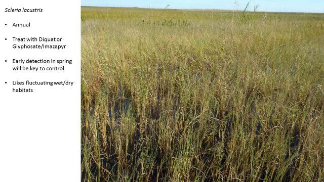
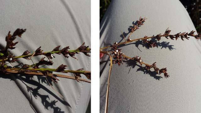
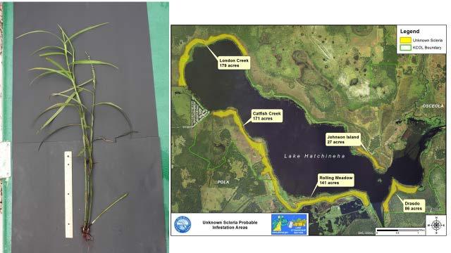
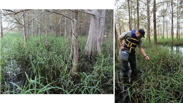
6 FWC is accepting Aquatic Habitat Restoration/Enhancement Subsection (AHRE) funding applications. AHRE Subsection is responsible for managing, enhancing, and preserving aquatic habitat in Florida for the long-term well-being of fish and aquatic wildlife and the benefit of the people of Florida. The deadline for the application is December 15 th, Questions about the application can be forwarded to Brent Bachelder. Brent Bachelder gave a Snail Kite (Rostrhamus sociabilis) update. From the October 31 st Okeechobee Snail Kite update, of the 41 nests that were active at the end of September, 13 are still active and 14 were successful. There have also been 23 new nests discovered since the hurricane. One new nest is between S-129 and Indian Prairie Canal and the rest are in the Moonshine Bay treatment areas. There are currently 23 active nests on Lake Okeechobee since the beginning of November. Brent Bachelder and Tyler Beck presented on Snail Kite nesting on Lake Okeechobee at the Snail Kite Coordinating Committee meeting on 10/13/2016. The presentation outlined that there was a unique nesting event on Lake Okeechobee where there was treated cattails. Moonshine Bay went from Eleocharis to cattail between 1972 and During May 2015, the cattail was treated in the Moonshine Marsh area. Then the treated cattail was burned with prescribed fire. These areas are 90% open water now (2016), willow clumps were not sprayed. Kite nests started getting heavy in July through September nest in willows mostly. Tyler gave SNKI nesting numbers as of the meeting but nesting continued. Most recent numbers (as of Nov 1) are 160 successful nests out of 230 total nests on Okeechobee. Of those, the Moonshine Bay area had 89 successful nests of 111 total nests. 23 nests are still active (all but 1 in Moonshine Bay). Brent Bachelder will be presenting on Lake Okeechobee Snail Kite nesting at the Greater Everglades Ecosystem Restoration meeting in April at Coral Springs, FL. Brent Bachelder spoke about the completed Spring 2016 emergent aerial treatments. FWC was able to aerially treat 2742 acres of Cattail (Typha sp.), 112 acres of Phragmites, and 225 acres of Torpedograss (Panicum repens), from Moonshine Bay up to and along the Kissimmee River. FWC utilized the herbicide Clearcast (Imazamox) at 32oz/acre to treat cattail. This was applied in order to reduce non-target damage. The herbicide was slow acting, but was successful in controlling the cattail. FWC utilized the herbicides Glyphosate and Imazapyr mix to control the Phragmites. FWC also used the Imazapyr/Glyphosate mix to control the Torpedo Grass. Brent Bachelder spoke on behalf of the Lake Okeechobee Fire Management Technical Sub- Committee. A DRAFT Lake Okeechobee Rx Burn Units map was shared with the Task Force (Attachment #2). The potential upcoming burn units are connected along with the previously treated Spring 2016 Herbicide Treatments. The proposed prescribed burns will take place when the wind and weather conditions permit. Additional proposed prescribed burns are also planned for the Southern Islands of Lake Okeechobee. The Fire Management Team had questions in regards to USACE fire disking operations. David Lattuca will coordinate disking operations with the Questions can be forwarded to Brent Bachelder. Alex Onisko presented on Scleria lacustris and Scleria microcarpa (Attachment #3). The lacustris species was recently discovered and treated in the Western Marsh of Lake Okeechobee. The microcarpa species was recently discovered in Lake Hatchineha (Attachment #4). Alex Onisko gave a presentation on how to properly identify Scleria and differentiate between the two species. Further questions can be forwarded to Alex Onisko. Susanna Toledo informed the Task Force that Lee County Hyacinth Control District (LCHCD) offered to help FWC manage invasive species in Lake Hicpochee. LCHCD will utilize both herbicide applications and use their mini-harvester. FWC and LCHCD will work together, in order to formulate a plan to manage the invasive species in Lake Hicpochee.
7 SFWMD Mike Bodle discussed the SFWMD s Ground Services Contracts, which have expired. All of the contracts were re-bided. The four firms have expanded to eight firms, with newly executed full contracts. There are three firms that can provide full aquatic plant management services. These contracts are available for interagency piggy-backing. The SFWMD has removed their aquatic plant management field applicator services. Mike Bodle also performed a bid release for grass carp, if anyone is interested in a bid price. New/Old Business Lake Okeechobee Watershed Project - Planning efforts are underway for the Lake Okeechobee Watershed (LOW) project, which aims to: Improve the quality, quantity, timing and distribution of water entering Lake Okeechobee Provide for better management of lake water levels Reduce high-volume discharges to the Caloosahatchee and St. Lucie estuaries downstream of the lake Improve system wide operational flexibility One of the next steps for implementation is to identify opportunities to restore the quantity, quality, and timing and distribution of flows into Lake Okeechobee. The LOW Project preliminary project area, where placement of features will be considered, covers a large portion of the Lake Okeechobee Watershed north of the lake. Okeechobee-Watershed-Project/ Lake Okeechobee RECOVER performance measures - RECOVER (REstoration COordination & VERification) is a multi-agency team of scientists, modelers, planners and resource specialists who organize and apply scientific and technical information in ways that are essential in supporting the objectives of the Comprehensive Everglades Restoration Plan (CERP). The RECOVER team conducts scientific and technical evaluations and assessments for improving CERP s ability to restore, preserve and protect the south Florida ecosystem while providing for the region's other water-related needs. RECOVER applies a system-wide perspective to the planning and implementation of the CERP and communicates and coordinates the results of these evaluations and assessments to managers, decision makers and the public. *** The next interagency flight is scheduled for the first Tuesday of every month. ***The next interagency meeting will be scheduled in the near future Adjournment David Lattuca adjourned the Task Force meeting at 11:00 A.M.
8 United States Army Corps of Engineers 525 Ridgelawn Rd. Clewiston, FL Tel Fax Attachment #1. RAG FY16 Annual Report ANNUAL REPORT FY 2016 Invasive Species Management (ISM) Branch, Lake Okeechobee and the Okeechobee Waterway (OWW), Removal of Aquatic Growth Project (RAG)
9 TABLE OF CONTENTS Contents Removal of Aquatic Growth Project (RAG) 1 RAG Cooperative Agreement between USACE and FFWCC. 2 End of FY16 RAG Project Tracking 3 Lake Okeechobee Water Levels 6 Task Force 7 Eligible Areas & Priority List 9 Contact Information 12 Agency Information 12
10 Removal of Aquatic Growth Project (RAG) PREFACE The U.S. Army Corps of Engineers, Jacksonville District Commander is committed to achieving successful execution of the Removal of Aquatic Growth Project to maintain navigation in eligible Federal navigation projects in the District. The District Commander has the ultimate responsibility for this project and is responsible for ensuring that products and actions of the district staff achieve desired results. BACKGROUND AND SCOPE OF THE PROBLEM The Removal of Aquatic Growth (RAG) Project was authorized by the Rivers and Harbors Act of 1899 to deal with navigation problems caused by the non-native water hyacinth plants that were introduced into Florida and Louisiana. The project has been expanded over the years to include other species (water lettuce, alligatorweed, hydrilla and melaleuca) and other states (Alabama, Mississippi and Texas). The Jacksonville District Invasive Species Management Branch utilizes Integrated Pest Management (IPM) to manage invasive species. IPM is the coordinated use of the most appropriate strategy to prevent or reduce unacceptable levels of invasive species and their damage by the most economical means, and with the least possible hazard to people, property and the environment. The District has a maintenance control program wherein the exotic floating plants are maintained at the lowest possible levels by IPM. This approach has reduced many of the adverse environmental effects caused by excessive vegetation. The beneficial effects of the maintenance control approach include: (1) reduction in the total amount of herbicide required to control a given area, (2) reduction in the amounts of decaying aquatic vegetation, (3) reduction in the need for extensive aerial application, (4) reestablishment of native species in controlled areas, and (5) relatively stable labor costs. If maintenance control is not achieved, the waterways will again experience severe problems. Due to the biological nature of the problem it is difficult to predict the exact problem acreage without control. In the absence of control the unrestricted use of the water bodies would be lost due to localized navigational and flow blockage. FY16 ANNUAL REPORT This report was designed to summarize the Removal of Aquatic Growth Project for Lake Okeechobee and the Okeechobee Waterway during FY16 (October 01, 2015 September 30, 2016). David Lattuca Biologist, Invasive Species Management Branch October 3, 2016 Page 1
11 RAG Cooperative Agreement between USACE and FFWCC. Page 2
12 End of FY16 RAG Project Tracking BOAT APPLICATORS TOTAL CHEMICAL COST $826, CREW AMOUNT PAID $900, TOTAL COST $1,727, TOTAL ACRES COST / ACRE $ HELICOPTER TOTAL CHEMICAL COST $119, CREW AMOUNT PAID $145, TOTAL COST $265, TOTAL ACRES 3500 COST / ACRE $75.88 TUSSOCK TOTAL CHEMICAL COST $3, CREW AMOUNT PAID $15, TOTAL COST $19, TOTAL ACRE 89 COST / ACRE $ FY16 TOTAL CHEMICAL COST $949, CREW AMOUNT PAID $1,062, TOTAL COST $2,012, TOTAL ACRE COST / ACRE $ Page 3
13 Adju vant Total Adjuvant Cost Amo unt Accuracy $14, Cohere $8, DLZ $ Foambuster $14.85 Induce $44, MSO $4, Concentrate Polycontrol II 1 $26.60 Quest $ Sunwet 30 $ Total $73, Herb icide Total Herbicide FWC Provided Amo unt Cost Cost Weedar $3, Shredder Amine $1, Tribune $95, Reward $64, Habitat 9 $ Roundup $7, Custom Rodeo $ Schooner $296, Clipper $13, $127, Galleon $238, $25, Total $723, $153, PROJECT TRACKING Plants treated are only for water hyacinth, water lettuce, and tussocks. Data was forwarded to USACE from FFWCC PMARS System Data was used from FFWCC Waterbodies: Lake Okeechobee, Caloosahatchee River, and Lake Hicpochee Herbicide Amount is recorded in Gallons or Pounds USACE Annual Report Tracking may differ from FFWCC s Project Tracking Page 4
14 ACRES TREATED BY MONTHS FROM FY10 THROUGH FY16 FY10 FY11 FY12 FY13 FY14 FY15 FY16 OCT NOV DEC JAN FEB MAR APR MAY JUN JUL AUG SEP FY 10 FY 11 FY 12 FY 13 FY 14 FY 15 FY16 Total Acres Page 5

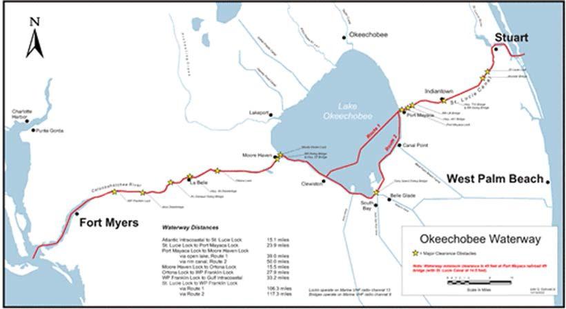
15 Lake Okeechobee Water Levels FY16 SAJ WATER MANAGEMENT GRAPHICAL PLOT Data are collected through automated process and interagency data exchange. Data are provisional and subject to change. The Lake Okeechobee is a 451,000 acre lake and the Okeechobee Waterway is a 154 mile long waterway which extends from the Atlantic Ocean at Stuart, to the Gulf of Mexico at Ft. Meyers. The waterway runs through Lake Okeechobee and consists of the Caloosahatchee River to the West of the lake and the St. Lucie Canal east of the lake. Page 6
16 Task Force OKEECHOBEE AQUATIC PLANT MANAGEMENT INTERAGENCY TASK FORCE THE CORPS OF ENGINEERS SHALL CHAIR, AND ACTIVELY SOLICIT PARTICIPATION IN THE LAKE OKEECHOBEE AQUATIC PLANT MANAGEMENT INTERAGENCY TASK FORCE. THE TASK FORCE MEMBERS WILL REPRESENT STATE OF FLORIDA AGENCIES (INCLUDING THE SOUTH FLORIDA WATER MANAGEMENT DISTRICT), STATE UNIVERSITIES, THE CORPS OF ENGINEERS, AND OTHER FEDERAL AGENCIES. THE TASK FORCE WILL SERVE IN AN ADVISORY CAPACITY, PROVIDING MULTI-DISCIPLINARY TECHNICAL AND SCIENTIFIC DATA FROM WHICH THE CORPS AQUATIC PLANT MANAGEMENT STRATEGY, METHODOLOGY, AND RESEARCH PLANNING AND OPERATIONAL EFFORTS WILL EVOLVE. THE FOCUS OF THE AQUATIC PLANT EFFORT WILL BE TO BENEFIT THE OVERALL ECOLOGICAL HEALTH OF LAKE OKEECHOBEE. Record Year for Acres Treated for Floating Plants on Lake Okeechobee 6 Task Force Meetings (Ranging from attendees) Weekly Schedule of Operation Updates Posted Treatment Notices to Task Force Kiosks. 12 I/A Flights with ongoing data collection/ GoPro footage Revised FloridaInvasives.org/Okeechobee and SAJ Websites Continued work with USDA-ARS Bio-Control releases Applicator and USACE safety (No Accidents Occurred) Continued collaboration with the Lake Okeechobee Fire Management Technical Sub-Committee Task Force participated with CISMA s (Cooperative Invasive Species Management Area) and FISP (Florida Invasive Species Partnership. Continued use of the Lake Okeechobee Project Proposal Form Added meeting venue at Lee County Hyacinth Control District (LCHCD) Ongoing Snail Kite Coordination between Agencies Work in partnership with Stakeholders regarding Fishing Tournaments Page 7
17 OPERATING TASK FORCE KIOSK LOCATIONS FOR LAKE OKEECHOBEE BOAT RAMPS 1. Clewiston Park 2. Clewiston Rim Canal 3. John Stretch Park 4. South Bay Access Area 5. Slim s Marina, Torry Island 6. J. Mark Marina, Torry Island 7. Torry Island Public Access Area 8. Paul Rardin Park 9. Pahokee Marina 10. Canal Point Access Area 11. Old Sportsman s Access Area 12. Caloosahatchee River Access Area 13. Alvin Ward Access Area 14. Uncle Joe s Marina 15. Okeechobee Park 16. Scott Driver Access Area 17. Okee Tantie Marina 18. Okee Tantie Airboat Ramp 19. Buckhead Ridge Marina 20. Indian Prairie Canal 21. Bear Beach Access Area (2) 22. Harney Pond Canal (5) 23. Fisheating Creek 24. Taylor Creek 25. Henry Creek 26. Nubbin Slough 27. S-135 Access Area 28. Port Mayaca Page 8
18 Eligible Areas & Priority List LAKE OKEECHOBEE REMOVAL OF AQUATIC GROWTH LIST OF ELIGIBLE AREAS 1. The following areas are eligible for aquatic plant control efforts. a. St. Lucie Canal from the St. Lucie Lock to the Port Mayaca Lock. b. Industrial Canal, including associated finger canals and boat basins, from the S-310 Lock at Clewiston (Hurricane Gate 2) to the Highway 27 Bridge. c. Caloosahatchee River (C-43) from Moore Haven to Franklin Lock. This includes Lake Hicpochee and all associated canal systems to the first structure. d. Lake Okeechobee: All areas within the confines of the Herbert Hoover Dike and associated tributaries as follows: 1) Rim Canal to its NW terminus west of State Road 78 Bridge. 2) Fisheating Creek, from its confluence with the Lake near Lakeport, Florida, to the eastern edge of Cowbone Marsh. 3) Harney Pond Canal to Structure S-71. 4) Indian Prairie Canal to Structure S-72. 5) Kissimmee River to Structures S-84 and S-65E. 6) Taylor Creek from S-193 Lock (Hurricane Gate 6) to S-192. This includes associated residential canals, LD-4 canal, Eagle Bay, and Lemkin Creek. 2. Eligibility under this contract ceases at the following structures on the Herbert Hoover Dike: a. Hurricane Gate 5 Canal Point. b. Hurricane Gate 4 and S-2 at Belle Glade / South Bay. c. Hurricane Gate 3 and S-3 at Lake Harbor. d. S-236. e. S-4. f. S-131 and the Lakeport Lock. g. S-129. h. S-127 and the Buckhead Ridge Lock. i. S-133 (Okeechobee). j. S-191 (Nubbin Slough). k. Henry Creek Lock. l. S-135 and the Chancy Bay Lock. Page 9


19 Page 10
20 AQUATIC PLANT CONTROL PRIORITY LIST 1. All aquatic plant material that poses an eminent threat to the navigation and / or flood control features of Lake Okeechobee, the Okeechobee Waterway and / or tributaries. This includes floating plant species, submersed vegetation (both rooted and free floating), emergent plants and tussock materials. 2. Floating vegetation (water hyacinth and water lettuce) including that in manmade canals that are connected to Lake Okeechobee, the Okeechobee Waterway and / or tributary streams. 3. New isolated hydrilla infestations in previously un-infested areas of Lake Okeechobee, the Okeechobee Waterway and tributaries. 4. Public access points such as boat ramps and boat trails to benefit the general public. Trails should not exceed 30 feet in width. This includes treatment of hydrilla and minor plants to provide access to existing open areas. 5. Creation of open areas in hydrilla to ensure the integrity of flood control and navigation structures and to provide enhanced fish and wildlife habitats. 6. Large-scale hydrilla control efforts in Lake Okeechobee, the Okeechobee Waterway and / or tributary streams. 7. Other hydrilla and / or minor plant treatments.

21 Contact Information DAVID LATTUCA BIOLOGIST Tel Agency Information United States Army Corps of Engineers 525 Ridgelawn Rd. Clewiston, FL Tel Fax

22 Attachment #2. DRAFT Lake Okeechobee Rx Burn Units


23 Attachment #3. Scleria lacustris Presentation

24
25


26
27


28

29 Attachment #4. FWC Weed Alert
30
Lake Okeechobee Aquatic Plant Management Interagency Task Force Meeting Proceedings
 Lake Okeechobee Aquatic Plant Management Interagency Task Force Meeting Proceedings The following individuals attended the Lake Okeechobee Aquatic Plant Management Interagency Task Force meeting on Wednesday,
Istokpoga Newswire Article Index
 Newswire Article Index Issue Year Month Page Article Name Author 38 2008 November 1-2 NEEPP - Northern Everglades & Estuaries Protection Program Bert Galloway, President FOI 38 2008 November 2-3 What s
Okeechobee Waterway Speed Restrictions
 Okeechobee Waterway Speed Restrictions Rulemaking Authority 327.46 FS. Law Implemented 327.46 FS. History New 9-18-88, Amended 12-7-89, Formerly 16N-24.010, Amended 10-1- 96, Formerly 62N-24.010, Amended
Staying in Tune with South Florida s Water Cycle for Scientists, Managers, and Policy Makers in 5 Minutes per Week
 Staying in Tune with South Florida s Water Cycle for Scientists, Managers, and Policy Makers in 5 Minutes per Week Robert Sobczak (Big Cypress Nat l Pres), Todd Hopkins (FWS), Kevin Kotun (Everglades National
Impacts of Freshwater Releases from Lake Okeechobee on Sanibel Island and the Coastal Waters of Lee County
 Photo by Sanibel Captiva Conservation Foundation The freshwater plume extends out of Redfish Pass into the Gulf of Mexico on July 10, 2013. The freshwater plume is clearly visible in the Gulf of Mexico
HERBERT HOOVER DIKE REHABILITATION PROJECT
 HERBERT HOOVER DIKE REHABILITATION PROJECT Update to the Broward County Water Advisory Board 19 September 2013 Ingrid Bon, PE Project Manager Forward Initial Levees Along Lake Okeechobee Authorized by
US Sugar Land Purchase, River of Grass Project, SugarHill Sector Plan, Amendment 1
 US Sugar Land Purchase, River of Grass Project, SugarHill Sector Plan, Amendment 1 Rivers Coalition September 24, 2014 Upper Chain of Lakes Lake Kissimmee Kissimmee River Caloosahatchee Estuary Lake Okeechobee
Collaborative. City of Stuart. September 7, Mark Perry, Executive Director Oceanographic Society. Upper Chain of Lakes
 Lake Okeechobee Collaborative Upper Chain of Lakes Lake Kissimmee Indian River Lagoon City of Stuart September 7, 2016 Kissimmee River Caloosahatchee Estuary Lake Okeechobee St. Lucie Estuary Everglades
The Istokpoga Newswire
 February 2009 The Newswire Friends of Lake Association, Inc. USACE Projects Update At the present time the U.S. Army Corps of Engineers (ACE) are working on two projects that involve Lake. One is on the
CENTRAL PROJECT: PLANNING EVERGLADES CENTRAL EVERGLADES RESTORING THE HEART OF THE EVERGLADES
 CENTRAL EVERGLADES PLANNING PROJECT: PRESENTED BY Gina Paduano Ralph, Ph.D. U.S. Army Corps of Engineers Jacksonville District Guy Carpenter Florida Fish and Wildlife Conservation Commission APRIL 2014
Caloosahatchee River Citizen s Association
 Caloosahatchee River Citizen s Association www.caloosahatchee.org Autumn 2002 Caloosahatchee Regional Park Plan Revised! Public Participation Pays off! Last fall the Lee County Parks & Recreation Department
Plan 6 Project. Stop the destructive discharges to the Northern Estuaries and Restore the River of Grass. Upper Chain of Lakes.
 Upper Chain of Lakes Plan 6 Project Lake Kissimmee Kissimmee River Indian River Lagoon Stop the destructive discharges to the Northern Estuaries and Restore the River of Grass Caloosahatchee Estuary Lake
Kerr Lake Vegetation Survey. October November Report submitted by NC State University. Background
 Kerr Lake Vegetation Survey October November 2012 Report submitted by NC State University Background Hydrilla (Hydrilla verticillata) is a non-native invasive submersed aquatic plant. This plant was first
Conserving the Forests, Lakes and Streams of Northeast Michigan
 4241 Old US 27 South, Suite 2, Gaylord, Michigan 49735 (989) 448-2293 www.huronpines.org info@huronpines.org Prioritized Restoration Projects in the AuSable River Watershed Summer 2015 Update from Huron
Kissimmee River Channelization
 Environmental Restoration ti Update Phil Flood, South Florida Water Management District Presentation Overview Kissimmee River Restoration Everglades Stormwater Treatment Areas Comprehensive Everglades
Indian River Lagoon: Lessons, Challenges and Opportunities
 Indian River Lagoon: Lessons, Challenges and Opportunities Upper Chain of Lakes Lake Kissimmee Kissimmee River Indian River Lagoon Caloosahatchee Estuary Lake Okeechobee St. Lucie Estuary Mark Perry, Executive
4344 GEORGE BOULEVARD, SEBRING, FL
 To: CC: Lake Istokpoga Management Committee members and alternates: Gary Albin, Bill Dwinell, Paul Gray, Rick Ingler, Flint Johns, Gary Lamperelli, Paul Phypers Jr., Jeanette Porter, Dick Reaney, Jim Reed,
The Blue Heron Slough Conservation Bank
 1 The Blue Heron Slough Conservation Bank CONSERVATION BANKING July 19-23, 2010 CASE STUDY SERIES The Blue Heron Slough Conservation Bank (Washington) I. OVERVIEW & BACKGROUND: Location: Snohomish River
LAKE JESUP VEGETATION MAPPING: AN INTER-AGENCY COLLABORATION. Lakshmi Sankaran, GISP Public Works Department, Seminole County
 LAKE JESUP VEGETATION MAPPING: AN INTER-AGENCY COLLABORATION Lakshmi Sankaran, GISP Public Works Department, Seminole County LAKE JESUP Area - 12 sq miles Shoreline - 53 miles Watershed - 136 sq miles
years, as liquid water and vapor, and I know Lake Okeechobee very
 V E R Y EAR LY Y HI H STO R Y HI FRIENDS. MY NAME IS WAYNE DROP. I KNOW, YOU MAY THINK IT S RAIN DROP, BUT NO, IT S WAYNE. I HAPPEN TO BE A WATER DROP WHO LIKES to tell stories, particularly about my favorite
Table 1. Physical Characteristics of Your Lake.
 The lake assessments are created in partnership with Hillsborough County and the Florida Center for Community Design and Research LAKE ASSESSMENT DOCUMENT White Trout Lake /8/98 Watershed: Sweetwater Creek
Invasive Aquatic Vegetation
 Sam Rayburn Reservoir B. A. Steinhagen Lake Invasive Aquatic Vegetation April 2012 Sam Rayburn Reservoir What s In A Name? Sam Rayburn Dam and Reservoir MaGee Bend Reservoir Sam Rayburn Powerhouse Town
2013 FEDERAL STORM RESPONSE
 2013 FEDERAL STORM Presented to the Florida Shore & Beach Association Sep 26, 2013 Presented by: COL Alan Dodd Commander, Jacksonville District September 2013 THE COLLABORATION 2 THE PROGRAM 3 THE STORMS
SR 693 (Pasadena Avenue) Corridor Study from Shore Drive South to 66 th Street
 Corridor Study from Shore Drive South to 66 th Street") Welcome and Introduction Sign-in and comment sheets Restrooms and exits Meeting agenda and timeline Meeting goals / expectations Provide input to guide study recommendations Actively participate throughout
Welcome and Introduction Sign-in and comment sheets Restrooms and exits Meeting agenda and timeline Meeting goals / expectations Provide input to guide study recommendations Actively participate throughout
Florida s Freshwater Fisheries. Mike S. Allen Mark W. Rogers Galen Kaufman. Chris M. Horton
 Evaluating Effects of Climate Change on Florida s Freshwater Fisheries Mike S. Allen Mark W. Rogers Galen Kaufman Chris M. Horton Methods Two parts: 1. Literature review to evaluate nationwide implications
Newswire. Friends of. Istokpoga
 Friends of Newswire Istokpoga Are the Lake Okeechobee Projects Going to Help Lake Istokpoga? By Bill Dwinell There are two Lake Okeechobee projects that could potentially help Lake Istokpoga, the Lake
Public Notice. Corps File No. LRE Date: March 19, 2017 Expires: March 18, 2022
 US Army Corps of Engineers Detroit District Public Notice Corps File No. LRE-2016-00006-100 Date: March 19, 2017 Expires: March 18, 2022 PUBLIC NOTICE ANNOUNCING REGIONAL CONDITIONS AND WATER QUALITY CERTIFICATIONS
Historical and planned changes in the south Florida ecosystem 1
 FA127 Historical and planned changes in the south Florida ecosystem 1 Alex Score and Charles Jacoby 2 The core of the south Florida ecosystem is a unique watershed, the Kissimmee Okeechobee Everglades
A Brief History of Lake Okeechobee Ecosystem Responses To Water Level Management
 A Brief History of Lake Okeechobee Ecosystem Responses To Water Level Management By: Paul N. Gray, Ph.D. Audubon Florida April 2017 Water management crises in and around Lake Okeechobee in 2016 brought
INDIANA REGIONAL GENERAL CONDITIONS FOR THE STATE OF INDIANA
 INDIANA REGIONAL GENERAL CONDITIONS FOR THE STATE OF INDIANA These regional conditions are in addition to but do not supersede the requirements in the Federal Register (Volume 82 No. 4 of January 6, 2017).
County of Orange Resources and Development Management Department Harbors, Beaches and Parks. Strategic Plan. HBP Strategic Plan Workshop 1.
 County of Orange Resources and Development Management Department Harbors, Beaches and Parks Strategic Plan HBP Strategic Plan Workshop 1 v18 PRESENTATION OUTLINE Harbors, Beaches & Parks (HBP) History
The Istokpoga Newswire
 November 2008 The Istokpoga Newswire Friends of Istokpoga Lake Association, Inc. Northern Everglades & Estuaries Protection Program How Will This Program Help Lake Istokpoga? By Bert Galloway, President
PROJECT OVERVIEW PROJECT AREA. FAHCE Fish Habitat Restoration Plan EIR
 PROJECT OVERVIEW PROJECT AREA FISH AND AQUATIC HABITAT COLLABORATIVE EFFORT (FAHCE) Fish Habitat Restoration Plan Project Area PROJECT OVERVIEW DOCUMENTS A Settlement Agreement Regarding Water Rights of
 Time of Change We Are Growing We Are An Attractive Place To Live We Are Age Diverse + Living Longer 50000 40000 30000 20000 10000 0 2010 Census Job Density Housing Sheds Transit Sheds The Project FUNDING
APPENDIX G: INTERSECTION NEEDS AT OKEECHOBEE BOULEVARD
 APPENDIX G: INTERSECTION NEEDS AT OKEECHOBEE BOULEVARD INTERSECTION NEEDS AT SR 7 and OKEECHOBEE BOULEVARD SR 7 Extension Project Development and Environment (PD&E) Study From Okeechobee Boulevard (SR
COMMUNITY WATERSHED PROJECT
 SABINE RED RIVER COMMUNITY WATERSHED PROJECT A Watershed Approach to Aquatic Resources Do you have a stake in the water, the wildlife, the use of the land? Help us do for fish what was done for ducks*.
Estimated on-the-ground start and end dates: 1 June October 2018
 A. Applicant Information Name of Organization: U.S. Army Corps of Engineers, Carlyle Lake 801 Lake Road, Carlyle, IL 62231 Contact Information: Robert Wilkins, Operations Manager, (618) 594-2484, Robert.Wilkins@usace.army.mil
FINAL Caples Lake Fisheries Management Plan. Version 4.0
 FINAL Caples Lake Fisheries Management Plan Version 4.0 August 15, 2008 Purpose The Caples Lake Fisheries Management Plan (Plan) outlines the stocking plan to reestablish a sport fishery in Caples Lake
Name of Applicant Phone Number # Mailing Address. City State Zip
 VIRGINIA DEPARTMENT OF GAME AND INLAND FISHERIES EXOTIC SPECIES APPLICATION/PERMIT TO IMPORT CERTIFIED TRIPLOID GRASS CARP FOR AQUATIC VEGETATION CONTROL IN PRIVATE PONDS (Under Authority of 4 VAC 15-30-40
Don t forget your Conference Code and Attendee ID! Missed the teleconference prompt on WebEx?
 CISMA Call Log-In Don t forget your Conference Code and Attendee ID! Missed the teleconference prompt on WebEx? You have 2 options to bring it back to the screen: 1. Click on the Audio tab and click on
Figure 1 Location Map
 Figure 1 Location Map Project Features Map Modified Water Deliveries to Everglades National Park and C-111 Projects (f) w 0:: o_ Bis::ayne Bay Flori~ Bay Figure 2. C-111 and MWD Project Features "'"' SlOHTINGS
located Let s go fishing Hydrilla
 Our Lake of the Month for November is Lake August (set your GPS to 27.2750-81.4136). The elevation of Lake August is 102.5. Lake August is a 52 acre dredge hole lake (man-made from a former wetland; see
Public Access and Recreational Use Policy Making for Chandler Slough Management Area
 Public Access and Recreational Use Policy Making for Chandler Slough Management Area Part of the Kissimmee River Public Use Area Florida Natural Resources Leadership Institute Class VII, Session 8 October
St. Johns River Water Supply Impact Study (WSIS)
") St. Johns River Water Supply Impact Study (WSIS) Michael G. Cullum, P.E. Chief, Bureau of Engineering & Hydro Science St. Johns River Water Management District The Water Supply Impact study is the most
St. Johns River Water Supply Impact Study (WSIS) Michael G. Cullum, P.E. Chief, Bureau of Engineering & Hydro Science St. Johns River Water Management District The Water Supply Impact study is the most
Aquatic Plant Management and Importance to Sport Fisheries
 Aquatic Plant Management and Importance to Sport Fisheries Presentation to Michigan Inland Lakes Convention May 2014 Mike Maceina Professor Emeritus School of Fisheries, Aquaculture, and Aquatic Sciences
CUSTOMER ADVISORY COMMITTEE
 CUSTOMER ADVISORY COMMITTEE January 25, 2017 TITLE VI This meeting, project, or study is being conducted without regard to race, color, national origin, age, sex, religion, disability or family status.
FLORIDA BAY: AN ECOSYSTEM ON THE BRINK
 E V E R G L A D E S R E S T O R A T I O N F A C T S H E E T FLORIDA BAY: AN ECOSYSTEM ON THE BRINK Background T he Florida Bay estuary is located at the southern edge of the Everglades ecosystem at the
Undeveloped Zoning Inventory February 2004
 Undeveloped Zoning Inventory February 2004 Prepared by Planning Department Undeveloped Zoning Inventory February 2004 Project Description: The Undeveloped Zoning Inventory (the Inventory) is a periodic
Lake Wales Ridge Prescribed Fire Strike Team Florida Fish and Wildlife Conservation Commission Agreement #05046 Final Report June 2007
 Lake Wales Ridge Prescribed Fire Strike Team Florida Fish and Wildlife Conservation Agreement #05046 Final Report June 2007 Background Lake Wales Ridge associated habitats support a suite of wildlife species
Python Management in South Florida
 Python Management in South Florida ECISMA Summit - July 25 th 26 th, 2017 Evan Freeman, Interagency Python Management Coordinator Florida Fish and Wildlife Conservation Commission Michael Kirkland, Scientist
SP-472 AUGUST Feral Hog Population Growth, Density and Harvest in Texas
 SP-472 AUGUST 2012 Feral Hog Population Growth, Density and Harvest in Texas Photo courtesy Jared Timmons, Texas AgriLife Extension Service Feral hogs (Sus scrofa) are non-native, highly adaptable, and
Restoration Project at Trout Run Nature Preserve
 Restoration Project at Trout Run Nature Preserve Report Prepared By Eli DePaulis, 12/30/17 Trout Run Nature Preserve is a 21.4-acre spring-fed wetland and upland ecosystem in Upper Allen Township, Cumberland
January 4, Addresses water quality within the Council program.
 Phil Rockefeller Chair Washington Tom Karier Washington Henry Lorenzen Oregon Bill Bradbury Oregon W. Bill Booth Vice Chair Idaho James Yost Idaho Pat Smith Montana Jennifer Anders Montana January 4, 2016
Gulf States Marine Fisheries Commission. Dave Donaldson Assistant Director
 Gulf States Marine Fisheries Commission Dave Donaldson Assistant Director Interjurisdictional Fisheries Program The purpose of the IJF Program: Promote and encourage state activities in support of management
Lake Taneycomo Fisheries Management. Shane Bush : Fisheries Management Biologist
 Lake Taneycomo Fisheries Management Shane Bush : Fisheries Management Biologist Lake Taneycomo Empire District Electric Company Impoundment Completed in 1913 2,8 acres 22 miles long Lake Taneycomo Table
Everything a Lake Should Be
 Everything a Lake Should Be It's not what we do that sets us apart. It's how and why we do it so well. RESPONSIBLE LAKE MANAGEMENT Since 1977, Aquatic Systems has been solving difficult waterway management
Wild Virginia and Heartwood first raised this issue at the May 19, 2014 public meeting.
 June 13, 2014 Karen Stevens Pat Sheridan, District Ranger Warm Springs Ranger District 422 Forestry Road Hot Springs, VA 24445 karenlstevens@fs.fed.us psheridan@fs.fed.us re: Lower Cowpasture Restoration
Conservation and Restoration Florida s Coastal Marshes: An Overview of MESS. Jeff Beal, Kent Smith, Erin McDevitt, Maria Merrill
 Conservation and Restoration Florida s Coastal Marshes: An Overview of MESS Jeff Beal, Kent Smith, Erin McDevitt, Maria Merrill FWC s MESS: -Marine/Estuarine Subsection -within Aquatic Habitat Conservation
Lake Texoma Advisory Committee
 Lake Texoma Authorized by Flood Control Act of 1938 Construction of dam completed in 1944 89,000 surface acres Largest lake in capacity in the Tulsa District Operated by the U.S. Army Corps of Engineers
SR 826/PALMETTO EXPRESSWAY EXPRESS LANES PD&E STUDY From US 1/SR 5/Dixie Highway to SR 836/Dolphin Expressway FPID No.: ETDM No.
 SR 826/PALMETTO EXPRESSWAY EXPRESS LANES PD&E STUDY From US 1/SR 5/Dixie Highway to SR 836/Dolphin Expressway FPID No.: 432639-1-22-02 ETDM No.: 14308 Newsletter 3 - March 2019 Incluye versión en español
FACT SHEET MCGREGOR LAKE RESTORATION HABITAT PROJECT POOL 10, UPPER MISSISSIPPI RIVER, WISCONSIN ENVIRONMENTAL MANAGEMENT PROGRAM
 FACT SHEET MCGREGOR LAKE RESTORATION HABITAT PROJECT POOL 10, UPPER MISSISSIPPI RIVER, WISCONSIN ENVIRONMENTAL MANAGEMENT PROGRAM LOCATION McGregor Lake is located within a mid-river island in Pool 10
ATTACHMENT F. Minnesota Department of Natural Resources. Marsh Lake Ecosystem Restoration Project
 ATTACHMENT F Minnesota Department of Natural Resources Marsh Lake Ecosystem Restoration Project Mussel Rescue and Translocation Plan for Pomme de Terre River Restoration (Prepared June, 2016) Attachment
ST. LOUIS SECTION PROJECT OF THE YEAR AWARD
 ST. LOUIS SECTION PROJECT OF THE YEAR AWARD Originality and Innovation The St. Louis Harbor Project is located in the Upper Mississippi River between the entrance to the Chain of Rocks Canal at River
Albeni Falls Dam Downstream Water Temperature Study Interim Results
 Albeni Falls Dam Downstream Water Temperature Study Interim Results Amy Reese, Chief Water Management Section Seattle District June 24, 2014 US Army Corps of Engineers What we hope to cover today Albeni
Post Hurricane-Irma ecological assessments
 Post Hurricane-Irma ecological assessments Nicholas G. Aumen US Geological Survey On behalf of many scientists April 25, 2018 Caveats and comments The Science Coordination Group sponsored a meeting on
2008 Florida Alligator Hunting Survey Report
 2008 Florida Alligator Hunting Survey Report The Alligator Management Program of the Florida Fish and Wildlife Conservation Commission surveyed alligator hunters that were permitted in 2008 to gather information
next trip? Bulrush and fishing areas Discussion of mitigation of ruined areas Better trip agenda (stick to times) or smaller sections/trip
 or smaller sections/trip") Overview Lake Istokpoga Advisory Committee Meeting 4 Bert J. Harris Jr. Agricultural Center, Conference Room 3 4509 George Blvd; Sebring, Florida 33875 December 13, 2018 Summary On Thursday, December 13,
Overview Lake Istokpoga Advisory Committee Meeting 4 Bert J. Harris Jr. Agricultural Center, Conference Room 3 4509 George Blvd; Sebring, Florida 33875 December 13, 2018 Summary On Thursday, December 13,
Marine Debris from Land to Sea: Holistic Characterization, Reduction and Education Efforts in New Hampshire
 Marine Debris from Land to Sea: Holistic Characterization, Reduction and Education Efforts in New Hampshire ABSTRACT Over time, the focus of marine debris research and work has shifted away from simply
Long Term Success and Future Approach of the Captiva and Sanibel Islands Beach Renourishment Program
 2017 National Conference on Beach Preservation Technology February 8-10, 2017; Stuart, Florida Long Term Success and Future Approach of the Captiva and Sanibel Islands Beach Renourishment Program Thomas
South Florida Algal Bloom Sampling Results July
 South Florida Algal Bloom Sampling Results July Sample Date Samples Collected By Samples Analyzed By Sampling Location (Latitude and Longitude) Depth (Meters) Algae ID (Type of Blue Green Algae) Microcystin
Ministry of Forests, Lands, and Natural Resource Operations OVERVIEW OF ANGLING MANAGEMENT PLANS FOR THE SKEENA WATERSHED
 Ministry of Forests, Lands, and Natural Resource Operations OVERVIEW OF ANGLING MANAGEMENT PLANS FOR THE SKEENA WATERSHED November 19, 2013 1.0 Intent of this Document This overview provides background
Annual Report for Fiscal Year and Future Plans for the Tillamook Bay Watershed Council
 Annual Report for Fiscal Year 2012-2013 and Future Plans for the Tillamook Bay Watershed Council A report prepared for the Tillamook County Board of Commissioners August 2013 Table of Contents: Recently
Florida Seagrass Integrated Mapping and Monitoring Program
 Florida Seagrass Integrated Mapping and Monitoring Program - 2004 The following document is composed of excerpts taken from the 2011 publication, Seagrass Integrated Mapping and Monitoring for the State
Kentucky Lock Project Update Inland Waterways Users Board
 Kentucky Lock Project Update Inland Waterways Users Board Mr. Don Getty Project Manager Nashville District Great Lakes and Ohio River Division 1 March 2018 The views, opinions and findings contained in
Water Resources Report RKLD Annual Meeting July 30, 2016
 Water Resources Report RKLD Annual Meeting 2016 July 30, 2016 Topics Hydrology Report Indianford Dam trash rack cleanout performance Experimental Project update Review of PAS project Twin floods- 1 to
Searsville Dam Removal
 Searsville Dam Removal A unique opportunity for all Presented by the Beyond Searsville Dam Coalition San Francisquito Creek flows into the San Francisco Bay near the Palo Alto Airport and Golf Course seen
CORPS FACTS. Harbor Dredging U.S. ARMY CORPS OF ENGINEERS BUILDING STRONG
 CORPS FACTS Harbor Dredging U.S. ARMY CORPS OF ENGINEERS BUILDING STRONG Disaster Response Sedimentation in the channel is caused by the normal cycle of silt movement, erosion from high water or heavy
Eastern Brook Trout Joint Venture Annual Report The Nature Conservancy 2013
 Eastern Brook Trout Joint Venture Annual Report The Nature Conservancy 2013 2013 Annual Performance Report Enhancing Connectivity in the Ash-Black Rock Sub-basin of the West Branch Narraguagus River. Project
Wood Storks & Wetlands. UCF Jan. 26, 2010 Jason Lauritsen Asst. Director Corkscrew Swamp Sanctuary
 Wood Storks & Wetlands UCF Jan. 26, 2010 Jason Lauritsen Asst. Director Corkscrew Swamp Sanctuary Stork Overview 1984 on Endangered Species List South Carolina, Georgia, Alabama & Florida Mature at 3-4
Wisconsin 511 Traveler Information Annual Usage Summary January 3, Wisconsin 511 Phone Usage ( )
") Wisconsin 511 Traveler Information 211 Annual Usage Summary January 3, 212 Overall to-date Summary 36 months of operation 1,16,63 total calls the 1 Million mark was passed on December 3, 212 3,627,527
Wisconsin 511 Traveler Information 211 Annual Usage Summary January 3, 212 Overall to-date Summary 36 months of operation 1,16,63 total calls the 1 Million mark was passed on December 3, 212 3,627,527
STRUCTURE S-65 PURPOSE SPILLWAY OPERATION
 STRUCTURE S-65 This structure is a reinforced concrete, gated spillway with discharge controlled by three cable operated, vertical lift gates, and a reinforced concrete lock structure with two pairs of
The Berggren Plan Nebraska s Plan to Improve Pheasant Hunting. John Laux, NGPC RWBJV Informational Seminar February 2, 2017
 The Berggren Plan Nebraska s Plan to Improve Pheasant Hunting John Laux, NGPC RWBJV Informational Seminar February 2, 2017 Long-Term Pheasant Decline in Nebraska Changes in Agricultural Land-Use *Source:
Chateaugay Lakes Milfoil Control Program
 Chateaugay Lakes Milfoil Control Program Summary of Activities and Findings for June August 29 Prepared By: Daniel L. Kelting Executive Director Adirondack Watershed Institute Paul Smith's College P.O.
Colorado West Slope Mule Deer Strategy Public Engagement Report
 Colorado West Slope Mule Deer Strategy Public Engagement Report S U M M A R Y P R E S E N T A T I O N T O C O L O R A D O P A R K S A N D W I L D L I F E C O M M I S S I O N P R E S E N T E D BY T H E
Understanding Today s Environmental Issues and the Oregon Stewardship Guidelines. David Phipps GCSAA NW Field Staff
 Understanding Today s Environmental Issues and the Oregon Stewardship Guidelines David Phipps GCSAA NW Field Staff My Roots Northwest Landscape Industries 1986-1990 The Oregon Golf Club 1990-2000 Stone
Section 2: Biodiversity at Risk
 Section 2: Biodiversity at Risk Preview Classroom Catalyst Objectives Biodiversity at Risk Current Extinctions Species Prone to Extinction How Do Humans Cause Extinctions? Habitat Destruction and Fragmentation
TOWN OF DENNIS 10 YR COMPREHENSIVE DREDGE PERMIT SEPTEMBER 10, 2013
 TOWN OF DENNIS 10 YR COMPREHENSIVE DREDGE PERMIT SEPTEMBER 10, 2013 WHAT IS IT? ALL NECESSARY PERMITS FOR DREDGING FOR PORTIONS OF BASS RIVER, SWAN POND RIVER, SESUIT HARBOR AND CHASE GARDEN CREEK ONE
Oregon Department of Fish & Wildlife Nearshore Marine Resource Management Strategy Public Meeting Notes: Roseburg, 4/1/05
 Oregon Department of Fish & Wildlife Nearshore Marine Resource Management Strategy Public Meeting Notes: Roseburg, 4/1/05 Meeting notes are summarized to capture the thoughts and opinions of individual
Overview Open Space and Recreation
 Overview Open Space and Recreation Open Space Plan (2004) Environmental Priority Areas Town Character Priority Areas Recreational Facilities maintained by the Town RSU 21 Recreational Facilities in Kennebunk
Eastern Brook Trout Joint Venture Completed Project Report Form
 Eastern Brook Trout Joint Venture Completed Project Report Form Project Title: Assessing the Efficacy of Remediating Episodic Low ph (and High Aluminum) Concentrations in Headwater Brook Trout Streams
Earth WEEK The Maumee Matters. Save Maumee Grassroots Organization. April 18 through April presents
 Save Maumee Grassroots Organization presents The Maumee Matters Earth WEEK 2014 April 18 through April 26 2014 because one day is just not long enough Everything Water:The Maumee Matters Earth Week 2014
Aquatic Invasive Species Initiatives in Texas. Luci Cook-Hildreth Texas Parks and Wildlife Dept.
 Aquatic Invasive Species Initiatives in Texas Luci Cook-Hildreth Texas Parks and Wildlife Dept. Aquatic Invasive Species in Texas Aquaculture Aquarium Releases Riparian Invasive Species Zebra Mussels Aquatic
STATUS REPORT FOR THE SUBMERGED REEF BALL TM ARTIFICIAL REEF SUBMERGED BREAKWATER BEACH STABILIZATION PROJECT FOR THE GRAND CAYMAN MARRIOTT HOTEL
 August 23 STATUS REPORT FOR THE SUBMERGED REEF BALL TM ARTIFICIAL REEF SUBMERGED BREAKWATER BEACH STABILIZATION PROJECT FOR THE GRAND CAYMAN MARRIOTT HOTEL performed by Lee E. Harris, Ph.D., P.E. Consulting
11426 Moorage Way P.O. Box 368 LaConner, WA Phone: Fax:
 Skagit River System Cooperative 11426 Moorage Way P.O. Box 368 LaConner, WA 98257-368 Phone: 36-466-7228 Fax: 36-466-447 www.skagitcoop.org BULL TROUT USE OF SWINOMISH RESERVATION WATERS Eric Beamer, Rich
PLAQUEMINES PARISH BARRIER ISLAND RESTORATION & SUSTAINABILITY. MVD/Gulf Coast Regional Dredging Meeting November 5, 2013
 PLAQUEMINES PARISH BARRIER ISLAND RESTORATION & SUSTAINABILITY MVD/Gulf Coast Regional Dredging Meeting November 5, 2013 OVERVIEW 1. Barrier Island Restoration Projects in Plaquemines Parish 2. Plaquemines
DALE HOLLOW LAKE TROOPER ISLAND IMPROVEMENT PROJECT Proposal for Reservoir Fisheries Habitat Partnership (RFHP)
") DALE HOLLOW LAKE TROOPER ISLAND IMPROVEMENT PROJECT Proposal for Reservoir Fisheries Habitat Partnership (RFHP) A. Applicant Information: US Army Corps of Engineers, Dale Hollow Lake POC: Gregg Nivens
DALE HOLLOW LAKE TROOPER ISLAND IMPROVEMENT PROJECT Proposal for Reservoir Fisheries Habitat Partnership (RFHP) A. Applicant Information: US Army Corps of Engineers, Dale Hollow Lake POC: Gregg Nivens
East Central Florida Region Matt Culver, Brevard County James Gray, Indian River County Jim Oppenbourn, St. Lucie County Kathy Fitzpatrick, Martin
 James Gray, Indian River County January 14, 2015 East Central Florida Region Matt Culver, Brevard County James Gray, Indian River County Jim Oppenbourn, St. Lucie County Kathy Fitzpatrick, Martin County
STUDY PERFORMANCE REPORT
 STUDY PERFORMANCE REPORT State: Michigan Study No.: 427 Project No.: F-81-R-1 Title: Measurement of sportfishing harvest in lakes Michigan, Huron, Erie, and Superior Period Covered: October 1, 1999 to
Response of a Newly Created Marsh-Wetland Affected by Tidal Forcing, Upland Discharge, and Groundwater Interaction
 Response of a Newly Created Marsh-Wetland Affected by Tidal Forcing, Upland Discharge, and Groundwater Interaction Mouth of Columbia River, Cape Disappointment State Park, Washington 12 Hans R. Moritz
Mutton Snapper Public Workshops February Florida Fish and Wildlife Conservation Commission Division of Marine Fisheries Management
 Mutton Snapper Public Workshops February 2016 Florida Fish and Wildlife Conservation Commission Division of Marine Fisheries Management Workshop Ground Rules All points of view are valid Behave with courtesy