Big Picture: 2. Setback:
|
|
|
- Marvin Fitzgerald
- 5 years ago
- Views:
Transcription
1 Hi Scott, Unfortunately, I will likely not be able to attend the Wednesday evening Planning Commission meeting. I m taking care of my 10 month old grandson (who doesn t do well with new faces and whose bedtime routine coincides with the meeting s schedule) for the week and my husband is chairing a volunteer board meeting Wednesday night. Please consider my input below. Is there any way my information can be forwarded to members of the Planning Commission? If submitted to them in written form on the night of the meeting, they will not be aware of my input prior to any decision making at the meeting. Having lived next to Island Park for 30+ years and potentially being greatly impacted by the specifics of the proposed zoning change, I think it important to have Planning Commission members aware of my input. Thank you very much for your help. Thank you, Scott, and the Planning Department for giving consideration to input of nearby residents regarding specifics of P Zoning. We very much appreciate your continuing work. Here is my further comment after reviewing the online packet for Wednesday s Planning Commission meeting: 1. Big Picture: My contention remains that we can build excellent schools and respect integrity of residential character at the same time with careful planning. Let s continue to work for an outcome that will do both! This is particularly important in a community such as Mercer Island where residents value our residential character and that character is integral to our comprehensive plan s the spirit and language. 2. Setback: a. As of Tuesday morning, setbacks for most impacted homes in the Lakes are not stated. I hope substantial increases are made to setbacks for Lakeridge neighbors as well as neighbors of other schools. The proposed height limits have increased greatly, the setbacks should as well. b. Setbacks could be implemented at the Island Park site to place the highest portions of the rebuilt structures further away from the northern boundary the only boundary from which homes can currently view the school. To the degree possible, this could help mitigate excessive height and mass, and resultant potential loss of light. Brad Fowler (also of SE 52 nd Pl) noted in his letter following the last Planning Commission meeting that there is a large piece of land at the SW quadrant of the Island Park property surrounded by treed border. I believe (you ll want to confirm) that these tall trees on the west perimeter are on IP property and if left in place could provide buffer to the houses in the Lansdowne Lane loop. Island Crest Park on the south. Brad noted this SW corner of lower field is wet ground not great for play field use in many seasons of the year, and would be a low impact screened location (if existing trees remain in place) for taller structures out of view of surrounding properties and below grade level of Island Crest Way. Focusing building on this lower southwest area would create least impact for homes to the north and provide a lovely wooded view from classrooms. - In order to mitigate height/mass and blocking light, this placement could be implemented with a 150 (or greater) setback from north bordering ROW (50 ROW setback = 200 from property line of the residents to the north to building) in conjunction with other setbacks on the west, south and east perimeters that would place the building and particularly tallest sections in the SW corner. Preferred choice.
2 - Alternatively, a 100 setback from north ROW with a 1.5 multiplier for height above 30 would likewise accomplish this. - Setbacks may need to be even greater to deal with shadow cast by tall buildings in the north-south lineup of any tall buildings in relation to the neighbors to the north. c. Regarding leaving a 45 setback for up to 2/3 of the area behind my home (about 65 of my 95 south perimeter line) in the updated proposal found online: In the process the multiplier for buildings taller than 30 was removed. Without that multiplier, the result: Depending on how tall the building is, one or the other formula will bring us closer/farther. In the case of the tallest building, we will be closer. Current & prior proposal allow: For easterly 350 : - 53 building, 45 setback from ROW = 95 setback* ( ROW) (Latest proposal) - 53 building, 30 setback + 1.5X 23 = 115 setback ( ROW (23). (Prior proposal) West of that: (For 1/3 of our south perimeter property line and for neighbors to the west) - 53 building, 30 setback from ROW ( ROW = 80 setback)* - *No multiplier for buildings taller than 30 in latest proposal. - In any case, these setback are inadequate to mitigate heights and shadows. (2b) is a better solution. d. Conversely to (2b) above, Dean Mack told me that the future Island Park rebuild will be in the location of the recently installed north side portable. This is immediately south of my home and on the only perimeter of IP from which homes currently view the school. 3. Height: a. 53 remains very tall; schools could be very large buildings. This mass/scale, likely of institutional proportions, remains out of character within our residential communities. Can we not do 2 stories and/or a gym without having to go up 53? b. I continue to believe helium balloons on 53 cords placed at setbacks (corners and where homes are impacted or where buildings would be sited, if known) would be tremendously helpful to the Planning Commission, the Planning Department and the residents in visualizing what the proposed setback and height limits mean. 4. Landscape: I continue to be concerned about screening, as was my neighbor, Brad Fowler, in his letter after the last Planning Commission meeting. a. We are talking about a whole new scale of height/mass in residential areas, so we need to think about screening in a whole new and more meaningful way. (Actually the heights/setbacks are the real problem, the resultant screening challenges are the unintended consequence.) It s very important to do this right. b. If I understand correctly.. I believe full screening is required for adjacent property owners and partial screening is required when part of the setback is ROW. Both will likely have marginal effect when screening such tall buildings. Furthermore, there is a substantial difference in those full/partial definitions. In our case we cannot see the ROW because the road dips
3 down, but the portable/school property is clearly visible from foundation up (because it is uphill from us). I believe partial screening is defined as: 1 tree (of unknown height/width) every 20 (but can be clustered instead, so wider gaps possible) at pedestrian level (not sure what that means, particularly when screening a building up to 53?) after 3 years of growth and not sure if it is required to be an evergreen? I can t see how this will mitigate the impact of a 53 building. Please consider a higher level of screening. As Brad requested in his letter, full screening would be appropriate. Full and partial screening likely need redefinition to provide expanded/more meaningful screening for buildings of this potential height/mass/scale. c. Special screening consideration is given to parking lots/driveways adjacent to the Lakes. Those should also apply to Island Park. d. Impacted neighbors should have approval rights regarding buffering landscape to verify light is not being blocked and screening is effective. 5. Shadows: Because of the north/south orientation of the Island Park property in relation to the neighbors to the north, special attention needs to be paid to impact on light/shadows and code needs to provide sufficient setbacks. 6. Portables: When the portable was placed south of our home last summer, it was subject to Design Commission review. The proposal indicates that will no longer be the case (Administrative Review instead), but doesn t show that as a change. Last summer s project left something to be desired from a management standpoint (see variance description of impact to vegetation/neighbors vs outcome). I believe inclusion of Design Commission review can only be a positive. 7. Site Visit: I know it is difficult to envision these heights/masses and their relationship to residential character. I again BEG Planning Commission members and City Planners to visit our home for a real life visual. View Island Park from our back deck or any south facing window of our home toward the portable. That portable is 10 from ROW (by variance to MISD) and high. Envision to a further setback (to approved code change + assuming not another variance) and add 38 additional height or for a total of 3+ times higher than current portable. Balloon floats on the lower field in the SW corner area and along the west perimeter could also provide helpful visualization on the difference that could make. Having added the balloon float to the visual will help to easier envision how the zoning changes would translate to practical application. My neighbors are aware that folks may drop by my backyard when we are not home, so they won t be concerned. These changes could forever change residential character. Working under the presumption that with creative thinking and thoughtful planning the goals of creating great schools and preserving residential character can happen together, might bring some surprisingly satisfactory results to all involved. Thank you very much for your consideration and your continued work on this project. Kathy Erickson 8731 SE 52 nd PL Home: , Cell:
4 From: To: Cc: Subject: Date: Attachments: Anne Carden Scott Greenberg MISD Residential rezone Tuesday, April 15, :00:05 PM MI PC MTG docx Dear Scott, I am writing to let you know that Jim and I are in full agreement with Kathy Erickson s letter that was sent to you today (attached here.) The City is currently working on a Re-zone of all school properties. Since we live directly across from Island Park School, the placement and size of the new structure will directly impact our property, as the newest Island Park portable has already done. As you know, that portable was placed such that it required a variance of the setback requirements to do so. (just last summer). Jim and I were involved with the community input phase of that project and were frankly disappointed in the way it was handled by the city. Now the School District/City plans to change the zoning for all schools. My understanding is that their plans call for the new building to be built as far north on the lot as possible and also be as tall as 47 or more. This plan would have a huge impact on our property. Our neighbors Kathy Erickson and Brad Fowler, as well as Jim and I have been following this issue, attending the meetings, writing letters and sharing info with a fairly large contingent of folks from Lakeridge and IMS. It is very time -consuming to stay updated on what is happening behind the scenes and all are very busy. It is a daunting process I would be so grateful if you could make note of our continued concerns regarding the details of this rezone. Thanks so much! Sincerely, Anne Carden anne.carden@comcast.net
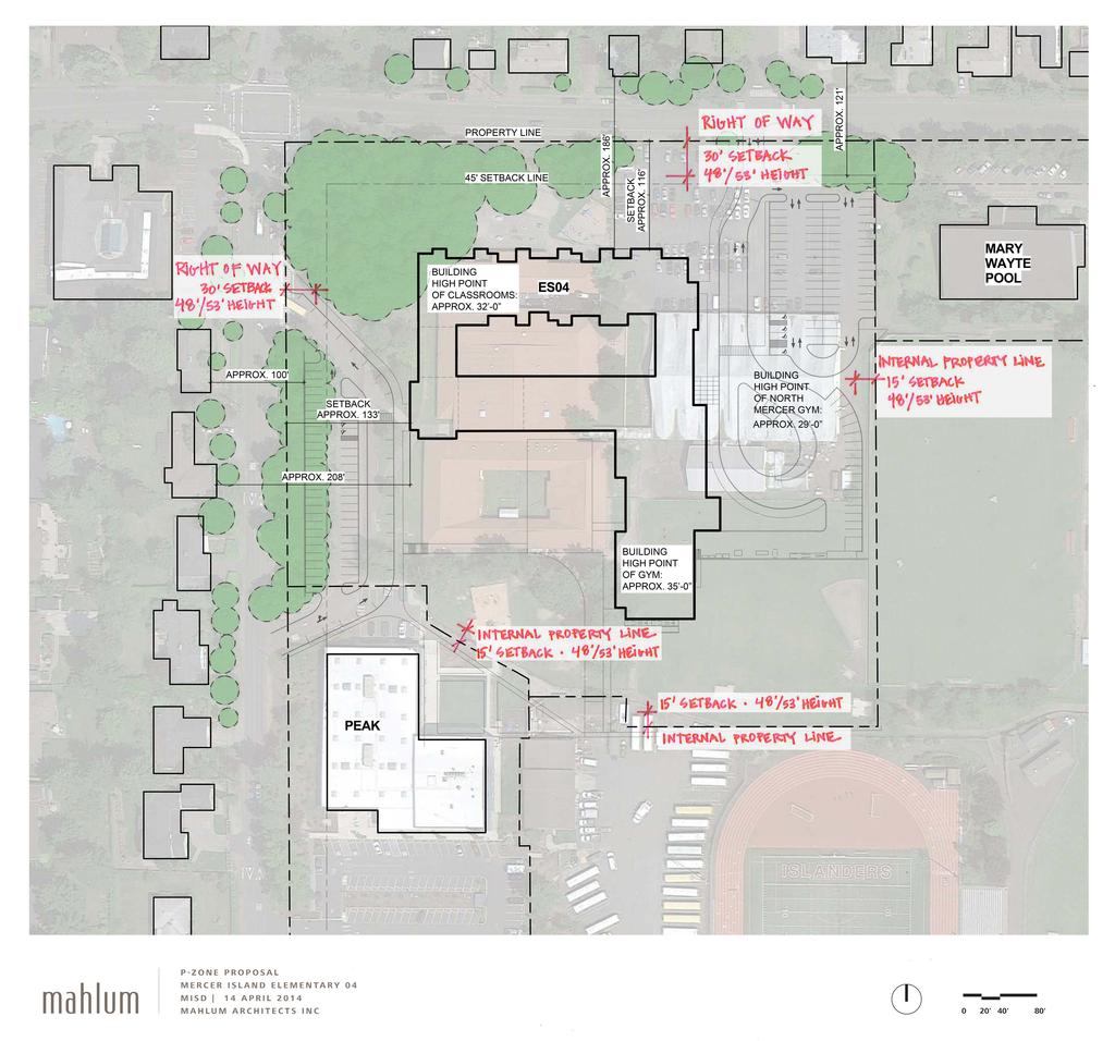
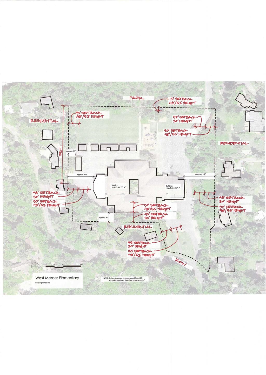
5 From: To: Cc: Subject: Date: Attachments: Brandy Fox Scott Greenberg Dean Mack 4/16/17 Planning Commission - Supplemental Information from MISD Wednesday, April 16, :35:33 PM Shadow Studies.pdf MIHS Zoning.pdf Elem 4 Zoning.pdf Island Park.pdf West Mercer.pdf Islander Middle School.pdf Lakeridge_Revised.pdf Scott, For this evenings Planning Commission meeting, we offer the following additional information: Site Specific Conditions Lakeridge: 200' setback along school's west property line with the four properties located at: 8121 and 8125 SE 79th Street, and 7870 and st Place SE. 48 /53 height allowed at 200 setback. 135 setback along school's west property line with parcel # /53' height allowed at 135' setback. Island Park: 45' setback for the easternmost 350' of the north property line, 30' height allowed at 45', added 2-1/2' (setback) : 1' (height) for a maximum height of 53' at 102-1/2' setback. Remainder of north property line adjacent to ROW, 30' setback at 48'/53'. Google Earth Graphics: The site specific setbacks and building heights have been drafted onto each plan. These are included for all six sites: Lakeridge, Island Park, West Mercer, New Elementary No. 4, Islander Middle School, and Mercer Island High School. Sun and Shadow study for structures on Mercer Island. Although I do not intend to use these graphics for my presentation, it would be helpful if the Google Earth Graphics and the Sun/Shadow study were available on the computer/projector in the event members of the Commission have questions. We ll see you tonight. Brandy Fox CPM Construction Planning & Management PO Box Seattle, Washington CPMSeattle.com
6


7 Sun and Shadow study for structures on Mercer Island, WA For 30 Structures For 40 Structures For 50 Structures shadows cast on the summer solstice at 10am shadows cast on the summer solstice at 10am shadows cast on the summer solstice at 10am 30 ft. tall 30 ft. tall Approx. 6 ft. 40 ft. tall 40 ft. tall Approx. 9 ft. 50 ft. tall 50 ft. tall Approx. 13 ft. Approx. 18 ft. Approx. 24 ft. Approx. 30 ft. shadows cast on the fall & spring equinox at 10am shadows cast on the fall & spring equinox at 10am shadows cast on the fall & spring equinox at 10am 30 ft. tall 30 ft. tall Approx. 15 ft. 40 ft. tall 40 ft. tall Approx. 26 ft. 50 ft. tall 50 ft. tall Approx. 37 ft. Approx. 29 ft. Approx. 40 ft. Approx. 50 ft. shadows cast on the winter solstice at 10am shadows cast on the winter solstice at 10am shadows cast on the winter solstice at 10am 30 ft. tall 30 ft. tall Approx. 85 ft. 40 ft. tall 40 ft. tall Approx. 121 ft. 50 ft. tall 50 ft. tall Approx. 157 ft. Approx. 62 ft. Approx. 84 ft. Approx. 104 ft.
8

9

10

11
12
13


14

15


16


17

18

19

20


21

22
Compliance with Section 18-52(4) City of Thornton Development Code
 City of Thornton Development Code") May 25, 2016 Jay Ruchti City of Thornton City Development Department 9500 Civic Center Drive Thornton, CO 80229 RE: Golf Safety Netting TOPGOLF Entertainment Complex (Southeast Corner of East 136 th Avenue
May 25, 2016 Jay Ruchti City of Thornton City Development Department 9500 Civic Center Drive Thornton, CO 80229 RE: Golf Safety Netting TOPGOLF Entertainment Complex (Southeast Corner of East 136 th Avenue
Arapahoe Square Zoning + Design Standards & Guidelines Task Force Meeting 9 January 27, 2016
 Arapahoe Square Zoning + Design Standards & Guidelines Task Force Meeting 9 January 27, 2016 Agenda 3:00 Opening/Welcome 3:15 Touch Base on Schedule and Milestones Moving Forward 3:20 Review the Overall
STAFF REPORT TO THE PLANNING COMMISSION December 12,2016. Schuler Shoes PUD Concept and Development Stage Plan And Rezoning
 STAFF REPORT TO THE PLANNING COMMISSION December 12,2016 PUD Concept and Development Stage Plan And Rezoning Applicant: Owner: Requested Action: Location: Zoning: Edward Farr Architects Brad Neuerburg
SITE AND BUILDING INFORMATION
 Page 1 Mr. Maneesh Poddar YORK Developments 303 Richmond St, Suite 201 London, ON N6B 2H8 Re: Preliminary Pedestrian Wind Assessment London, Ontario RWDI Reference Number: 1701848 Email: maneesh.poddar@yorkdev.ca
RE: Natomas Landing (P99-091)
") August 2, 2008 David Hung, Associate Planner Current Planning Division Development Services Department 300 Richards Boulevard, 3rd Floor Sacramento, CA 95811 RE: Natomas Landing (P99-091) Dear Mr. Hung:
August 2, 2008 David Hung, Associate Planner Current Planning Division Development Services Department 300 Richards Boulevard, 3rd Floor Sacramento, CA 95811 RE: Natomas Landing (P99-091) Dear Mr. Hung:
City of Seattle Edward B. Murray, Mayor
 City of Seattle Edward B. Murray, Mayor Department of Transportation Scott Kubly, Director Eastlake Community Council 117 E Louisa St. #1 Seattle, WA 98102-3278 January 28, 2016 RE: Roosevelt to Downtown
Wyldewood Estates. Pre-Application Public Engagement Summary of Issues and Responses
 Wyldewood Estates Pre-Application Public Engagement Summary of Issues and Responses March 2016 Executive Summary Morguard Residential Properties has been thoughtfully planning the redevelopment of Wyldewood
Highland Park Glengarry Court. Landscape design and Fencing rules
 Highland Park Glengarry Court Landscape design and Fencing rules Introduction Glengarry Court is to be developed as a comprehensive precinct with its own identity within Highland Park. This includes the
Vision: Traditional hamlet with an attractive business/pedestrian friendly main street connected to adjacent walkable neighborhoods
 N D. Focus Area II Vision: Traditional hamlet with an attractive business/pedestrian friendly main street connected to adjacent walkable neighborhoods Transit Road Focus Area II is located in the Hamlet
Dear Ms. Maw: Qualitative Pedestrian Level Wind Assessment St-Charles Market, 135 Barrette Street, Ottawa GWE File No.
 December 11, 2015 Jenna Maw LineBox Studio Inc. 126 York Street, Suite 502 Ottawa, Ontario K1N 5T2 Dear Ms. Maw: Re: Qualitative Pedestrian Level Wind Assessment St-Charles Market, 135 Barrette Street,
Town of Kiawah Island Board of Zoning Appeals
 Town of Kiawah Island Board of Zoning Appeals March 19, 2018 Town of Kiawah Island Municipal Center 4475 Betsy Kerrison Parkway Kiawah Island, SC 29455 CASE# BZA-12-17-00233 Applicant/Property Owner(s):
Donald Ballanti, Certified Consulting Meteorologist, Wind Impact Evaluation for the Menlo Park Facebook Campus Project, August 26, 2011.
 3.4 WIND Introduction This section describes wind conditions in the Project area and at the Project site. This section provides a general discussion of the relationship between building design and wind
APPENDIX 11 WIND EFFECTS ASSESSMENT
 APPENDIX 11 WIND EFFECTS ASSESSMENT Summerset Villages (Lower Hutt) Ltd District Plan Change Request Prepared by Urban Perspectives Ltd 17 September 2014 341 49 342 Opus Research Report 14-529D84.00 Wind
SITE AND BUILDING INFORMATION. March 28, 2018
 March 28, 2018 Mr. Carlos Ramirez Project Manager YORK Developments 303 Richmond St, Suite 201 London, ON N6B 2H8 carlos.ramirez@yorkdev.ca Re: Preliminary Pedestrian Wind Study 131 King Street - London,
GIS Based Data Collection / Network Planning On a City Scale. Healthy Communities Active Transportation Workshop, Cleveland, Ohio May 10, 2011
 The Purpose of GIS Based Network Planning GIS Based Data Collection / Network Planning Healthy Communities Active Transportation Conference Tuesday, May 10, 2011 10:00 AM Norman Cox, LLA, ASLA. Ann Arbor,
MARLWOOD GOLF & COUNTRY CLUB WASAGA BEACH, ONTARIO
 MARLWOOD GOLF & COUNTRY CLUB WASAGA BEACH, ONTARIO Prepared for: Marlwood Golf & Country Club 445 Golf Course Road Wasaga Beach, Ontario L0L 2P0 Prepared by: MBTW Golf Design 255 Wicksteed Avenue Unit
City of Wilsonville 5 th Street to Kinsman Road Extension Project
 City of Wilsonville 5 th Street to Kinsman Road Walking Tour & Neighborhood Workshop Summary Report Public Outreach Overview On July 18 th, 2017, the City of Wilsonville hosted a neighborhood walking tour
10A. DATE: October 5, Pedestrian and Bicycle Advisory Committee. Kevin Colin, Deputy Planning Manager Curt Bates, City Engineer
 10A DATE: October 5, 2016 TO: PREPARED BY: SUBJECT: Pedestrian and Bicycle Advisory Committee Kevin Colin, Deputy Planning Manager Curt Bates, City Engineer Discussion and Provide Comments, Associated
OPEN HOUSE WELCOME Bronte Village Growth Area Review
 OPEN HOUSE WELCOME Bronte Village Growth Area Review Bronte Village is a growth area. Learn more! Introduction Bronte Village is a growth area. What is that? Bronte Village is one of six growth areas identified
To: Planning Commission Date: September 19, 2012 From: By: Subject:
 To: Planning Commission Date: September 19, 2012 From: By: Subject: City of Woodinville, WA Report to the planning commission 17301 133 rd Avenue NE, Woodinville, WA 98072 www.ci.woodinville.wa.us Richard
City of Birmingham Draft Multi-modal Transportation Plan
 City of Birmingham Draft Multi-modal Transportation Plan City Commission Public Hearing Monday, November 25, 2013 7:30 pm Norman Cox, PLA, ASLA The Greenway Collaborative, Inc. Ann Arbor, Michigan The
CITY OF SAINT JOHN TRAFFIC CALMING POLICY
 CITY OF SAINT JOHN TRAFFIC CALMING POLICY VERSION: 1.0 April 10, 2012 Pedestrians, Cyclists and Motorists Sharing Street Spaces CONTENTS INTRODUCTION... 3 POLICY GOAL... 3 POLICY OBJECTIVES... 3 GUIDING
STATE OF VERMONT ENVIRONMENTAL COURT } } } } } Decision and Order
 STATE OF VERMONT ENVIRONMENTAL COURT In re: Appeal of Ted S. Gladstone and Kathleen Hoisington Docket No. 190-10-99 Vtec Decision and Order Appellants appealed from a decision of the Planning Commission
C C C
 C-012-001 Thank you for your support for the creation of new public space and nonmotorized access between downtown and the waterfront through the Overlook Walk, the East-West Connections, and the Promenade.
GIS Based Non-Motorized Transportation Planning APA Ohio Statewide Planning Conference. GIS Assisted Non-Motorized Transportation Planning
 The Purpose of GIS Assisted Network GIS Assisted Non-Motorized Transportation 2011 APA Ohio Statewide Conference Friday, 10:45 AM to Noon Focus on near-term projects wwwgreenwaycollabcom The purpose of
Community Meeting: Proposed Development 4520 Penn Ave. Notes January 30, :30-8:30pm
 Community Meeting: Proposed Development 4520 Penn Ave. Notes January 30, 2017 6:30-8:30pm Attendance: 17 community members Welcome and Introductions- Christina Howell Christina introduced herself as the
PARK(ING) DAY 2018 GUIDELINES
 DAY 2018 GUIDELINES") PARK(ING) DAY 2018 GUIDELINES PARK(ING) Day happens once a year, on the third Friday in September. This year the event takes place on Friday September 21. It is an opportunity for people to temporarily
PARK(ING) DAY 2018 GUIDELINES PARK(ING) Day happens once a year, on the third Friday in September. This year the event takes place on Friday September 21. It is an opportunity for people to temporarily
12/13/2018 VIA
 12/13/2018 VIA EMAIL Daniel Abbes, Assistant Planner City of Sacramento community Development Department 300 Richards Blvd., 3 rd Floor Sacramento, CA 95811 RE: Bruceville Apartments (P18-073) Dear Mr.
Management of Multi-Lane Highways in Jordan (Case Study)
") Management of Multi-Lane Highways in Jordan (Case Study) Basim Jrew 1), Nidal Hussein 2) and Rami Al-Kouz 3) 1) Isra University, Jordan. E-Mail: basim.jrew@iu.edu.jo 2) Isra University, Jordan. E-Mail:
Management of Multi-Lane Highways in Jordan (Case Study) Basim Jrew 1), Nidal Hussein 2) and Rami Al-Kouz 3) 1) Isra University, Jordan. E-Mail: basim.jrew@iu.edu.jo 2) Isra University, Jordan. E-Mail:
Building a Liveable Ottawa 2031 Backgrounder 5: Barrhaven/Riverside South/Leitrim
 Building a Liveable Ottawa 2031 Backgrounder 5: Barrhaven/Riverside South/Leitrim Wards 3 and 22 Official Plan Transportation Master Plan Cycling Plan Pedestrian Plan October 2013 ottawa.ca/liveableottawa
TENW Transportation Engineering NorthWest
 TENW Transportation Engineering NorthWest MEMORANDUM DATE: May 16, 2018 PRELIMINARY DRAFT TO: FROM: SUBJECT: Angelie Stahlnecker City of Fircrest Jeff Schramm TENW Response to Comments from City of Tacoma
TENW Transportation Engineering NorthWest
 DRAFT FOR CLIENT REVIEW ONLY TENW Transportation Engineering NorthWest MEMORANDUM DATE: August 22, 2017 TO: FROM: SUBJECT: Patrick Yamashita City of Mercer Island Chris Forster, P.E. TENW Trip Generation
David Hung, Associate Planner City of Sacramento Community Development Department 300 Richards Boulevard, 3 rd Floor Sacramento, CA
 June 13, 2016 VIA EMAIL David Hung, Associate Planner City of Sacramento Community Development Department 300 Richards Boulevard, 3 rd Floor Sacramento, CA 959811 RE: Fire Station 14 (DR16-128) Dear Mr.
THIS PAGE INTENTIONALLY BLANK
 THIS PAGE INTENTIONALLY BLANK Readers Guidance: This chapter provides responses to all comments submitted on the Draft Supplemental EIR of November 2011. All comments have been numbered and a corresponding
Abstract. Background. protected/permissive operation. Source: Google Streetview, Fairview/Orchard intersection
 ITE 2015 Western District Annual Meeting Ada County Highway District s Flashing Yellow Arrow Initiative Primary Author: Tim Curns, PE Ada County Highway District Traffic Engineer Author: Andrew Cibor,
BAINBRIDGE ISLAND AQUATICS FEASIBILITY STUDY 01/17/2019
 BAINBRIDGE ISLAND AQUATICS FEASIBILITY STUDY Outline Public Outreach Jurisdiction Requirements Site Analysis Site Design Plans Pricing Operational Study Slide 2 of 47 Outline PUBLIC OUTREACH Primary Users
SHANDON ADVISORY COUNCIL P. O. Box 92 Shandon, California Subject: Comments to PC on March 10, 2011, Hearing item 4
 SHANDON ADVISORY COUNCIL P. O. Box 92 Shandon, California 93461 shandoncouncil@yahoo.com Commissioners San Luis Obispo County Planning Commission 976 Osos St. San Luis Obispo, CA 93408 Via Electronic Mail
RZC Appendix 8A Marymoor Subarea Street Requirements
 RZC Appendix 8A Marymoor Subarea Street Requirements For additional design details for Marymoor Subarea infrastructure, refer to the 2017 Marymoor Subarea Infrastructure Planning Report. STREET REQUIREMENTS
Module 3 Developing Timing Plans for Efficient Intersection Operations During Moderate Traffic Volume Conditions
 Module 3 Developing Timing Plans for Efficient Intersection Operations During Moderate Traffic Volume Conditions CONTENTS (MODULE 3) Introduction...1 Purpose...1 Goals and Learning Outcomes...1 Organization
Executive Summary Route 30 Corridor Master Plan
 Route Corridor Master Plan Project Overview The Route Corridor Master Plan is a coordinated multimodal transportation and land use plan for the entire stretch of Route through East Whiteland Township,
August 3, Bay Trail Connection With The Community
 Ms. Lina Velasco, Senior Planner City of Richmond Planning Division P.O. Box 4046 Richmond, CA 94804 Dear Ms. Velasco: August 3, 2009 73 Belvedere Ave. Richmond, CA 94801 Phone/Fax: 510-235-2835 Email:tracbaytrail@earthlink.net
Garden City State Street Corridor Existing Conditions October 2012
 Garden City State Street Corridor Existing Conditions October 2012 Prepared by Garden City Development Services Leon Letson, Missy Harris & Jenah Thornborrow 6015 Glenwood Street Garden City, Idaho 83714
Bramshaw traffic calming proposal
 - 1 - Bramshaw traffic calming proposal Initial options appraisal report July 2017 - 2-1. Project background Hampshire Country Council has commissioned Test Valley Borough Council to carry out an option
Vicinity Map. Proposed Roosevelt Street Sidewalk Project OVERLAND ROAD TO CASSIA STREET W ROSE HILL ST W ALBION ST S OWYHEE ST W CASSIA ST
 Vicinity Map W ROSE HILL ST Cassia Park W CAMAS ST LEGEND W ALBION ST S ROOSEVELT ST W CASSIA ST Sacred Heart W KOOTENAI ST Monroe Elementary S OWYHEE ST South Junior High S SHOSHONE ST Project area Bus
Neighborhood Design. City Council Update June 4, 2018
 Neighborhood Design City Council Update June 4, 2018 Stakeholder Committee Stakeholder Meetings (7 meetings) Planning Commission Update City Council Update Stakeholder Committee Review / Revisions Council
City of Sammamish. Welcome. Issaquah-Fall City Road Improvements Project Phase I Design: 242nd Avenue SE to Klahanie Drive SE
 Welcome Welcome to the third community meeting for the Issaquah-Fall City Road Improvements Project. AGENDA 6:00 p.m. Welcome and sign-in 6:10 p.m. Presentation 6:50 p.m. Open house Learn about the roadway
Appendix 7. Wind and Comfort Impact Analysis
 Appendix 7 Wind and Comfort Impact Analysis Donald Ballanti Consulting Meteorologist 1424 Scott Street El Cerrito, CA 94530 (510) 234-6087 Abe Leider Rincon Consultants 449 15th Street, Suite 303 Oakland,
Community Meeting February 27, 2007 Dorchester Avenue Transportation & Streetscape Improvements Action Plan February 27, 2007
 Community Meeting Tonight s Agenda 6:00 Introductions South Boston/Dot Ave Improvement Study Background 6:15 Consultant Introductions Review of Scope and Schedule Review of Proposed Corridor Wide Guidelines
MAG Town of Cave Creek Bike Study Task 6 Executive Summary and Regional Significance Report
 Page 1 MAG Town of Cave Creek Bike Study Task 6 Executive Summary and Regional Significance Report August 1, 2012 MAG Project #481 Page 2 Task 6 Executive Summary and Regional Significance Report Introduction
Comments EXECUTIVE SUMMARY
 Comments 1. Under any Alternatives, MCDOT should provide better at-grade pedestrian crossing of Georgia Avenue and Forest Glen Road, including improved crosswalks with wider medians and adequate signal
Town of Mooresville, North Carolina Neighborhood Traffic Calming and Control Device Policy
 Town of Mooresville, North Carolina Neighborhood Traffic Calming and Control Device Policy Adopted January 6, 2014 Town of Mooresville Development Services Department TOWN OF MOORESVILLE NEIGHBORHOOD TRAFFIC
San Tomas Expressway
 Implementation Plan San Tomas Expressway Roads and Airports Department August 19, 2003 Implementation Plan San Tomas Expressway County of Santa Clara Roads and Airports Department 101 Skyport Drive San
Fleur Drive Reconstruction
 Fleur Drive Reconstruction October 29, 2018 1 Agenda: Fleur Drive Reconstruction Project Scope & Cost Overview Fleur Drive Cross Section Elements - Travel Lane Widths - Sidewalk Widths - Parkway Widths
RE: Minor Betterments Projects near William Walker Elementary
 Washington County Department of Land Use and Transportation Operations & Maintenance Division Attn: Minor Betterments Program Coordinator 1400 SW Walnut Street, MS 51 Hillsboro, OR 97123 lutops@co.washington.or.us
2011 SEA-KING DISTRICT II 3A GIRLS SWIMMING AND DIVING CHAMPIONSHIPS November 4 th and 5 th, 2011
 2011 SEA-KING DISTRICT II 3A GIRLS SWIMMING AND DIVING CHAMPIONSHIPS November 4 th and 5 th, 2011 SITES: Swimming: Mary Wayte Pool, 8815 SE 40 th, Mercer Island, WA (206) 296-4370 Diving: Juanita High
Downtown Davidson Pedestrian and Bicycle Safety Plan
 Downtown Davidson Pedestrian and Bicycle Safety Plan Enhancement Funds Application Submitted by the Town of Davidson June 2002 Downtown Davidson Pedestrian and Bicycle Safety Plan Project Description At
June 11, RE: Comments on the ENF for The Boston Garden project, MEPA # Dear Mr. Sullivan:
 June 11, 2013 Secretary Richard K. Sullivan, Jr. Executive Office of Energy and Environmental Affairs (EEA) Attn: Deirdre Buckley 100 Cambridge Street, Suite 900 Boston MA 02114 RE: Comments on the ENF
ALLEY 24 TRAFFIC STUDY
 ALLEY 24 TRAFFIC STUDY in City of Frostburg, Maryland January 2013 3566 Teays Valley Road Hurricane, WV Office: (304) 397-5508 www.denniscorporation.com Alley 24 Traffic Study January 2013 Frostburg, Maryland
Subject: Wind Impact Evaluation for the Facebook Campus Project, Menlo Park
 Donald Ballanti Certified Consulting Meteorologist 1424 Scott Street El Cerrito, CA 94530 (510) 234-6087 Fax: (510) 234-6087 Justin Murphy, AICP Community Development Department City of Menlo Park 701
Plainfield Gateway. Plainfield Context
 Plainfield Gateway The western arm of The Campus, much like the Thomas Street Placita eastern arm, must connect residents and workers from the western side of the neighborhood to The Campus and the activity
Hale iwa Improvement District Project
 Hale iwa Improvement District Project Hale iwa, North Shore, O ahu October 10, 2017 Public Informational Meeting Environmental Impact Statement Preparation Notice Waialua Elementary School 67-020 Waialua
Village of Plainfield Design and Operational Guidelines for Outdoor Uses within the Public Right-of-Way
 Village of Plainfield Design and Operational Guidelines for Outdoor Uses within the Public Right-of-Way Table of Contents 1. Applicability... 2 Purpose: The Village of Plainfield wishes to allow outdoor
FONTAINE AVENUE STUDY Final Report
 FONTAINE AVENUE STUDY Final Report March 28, 2005 FONTAINE AVENUE STUDY City of Charlottesville March 28, 2005 Renaissance Planning Group Kenneth Schwartz, FAIA, AICP Director of Design Leigh Wilkerson,
RECOMMENDED MOTION: I MOVE TO PASS SECOND READING AND ADOPT ORDINANCE 556, TO REMOVE NE 173RD STREET FROM THE DESIGNATED PEDESTRIAN-ORIENTED STREETS.
 CITY OF WOODINVILLE, WA REPORT TO THE CITY COUNCIL 17301 133rd Avenue NE, Woodinville, WA 98072 wvvw.ci.woodinville.wa.us To: Honorable City Council Date: 02/05/2013 From: Richard A. Leahy, City Manager
CITY OF ANN ARBOR TRAFFIC CALMING PROGRAM PROCESS OVERVIEW. Petitioner defines the project area limits and gathers petition signatures.
 CITY OF ANN ARBOR TRAFFIC CALMING PROGRAM PROCESS OVERVIEW Step 1: Petition Petitioner defines the project area limits and gathers petition signatures. 50% of addresses within the project area must sign
ACTION TRANSMITTAL No
 Transportation Advisory Board of the Metropolitan Council of the Twin Cities DATE: August 25, 2016 TO: FROM: ACTION TRANSMITTAL No. 2016-47 Technical Advisory Committee TAC Funding and Programming Committee
PROPOSED BICYCLE AND PEDESTRIAN FACILITY Vicinity of Route 123/I-495 Interchange Tysons, Fairfax County, Virginia
 PROPOSED BICYCLE AND PEDESTRIAN FACILITY Vicinity of Route 123/I-495 Interchange Tysons, Fairfax County, Virginia PRELIMINARY ENGINEERING REPORT Prepared for: Prepared by: July 2017 Table of Contents 1
As a resident of Plainfield Township, I have a few questions and concerns regarding the proposed Kuttshill development. They are listed below.
 Carly, Your email went into my spam. I will forward it onto the PC members later this morning. In regard to your questions I have answered them in blue below: As a resident of Plainfield Township, I have
5 CIRCULATION AND STREET DESIGN
 5 CIRCULATION AND STREET DESIGN This chapter describes circulation and streetscape improvements proposed for the Northwest Chico Specific Plan Area. It includes detailed design specifications for existing
Arch 463 ECS Fall Midterm I. 30 Multiple Choice Questions
 1 Arch 463 ECS Fall 2018 Name Midterm I 30 Multiple Choice Questions 1. Since 1901 the warming climate has most affected A. northern polar regions B. northern temperate regions C. equatorial regions equally
SEWARD MERIDIAN PARKWAY IMPROVEMENTS, PHASE II Palmer-Wasilla Highway to Seldon Road Project Number Z / EVENT NOTES
 SUBJECT: SEWARD MERIDIAN PARKWAY IMPROVEMENTS, PHASE II Palmer-Wasilla Highway to Seldon Road Project Number Z512210000/0001417 EVENT NOTES Seward Meridian, Phase II PROJECT NUMBER: Z512210000/0001417
CITY OF NAPLES STAFF REPORT
 Meeting of 8/9/17 Variance Petition 17-V5 CITY OF NAPLES STAFF REPORT To: Planning Advisory Board From: Planning Department Subject: Variance Petition 18-V2 Petitioner: Ian & Catherine Delaney Agent: Jeff
CITY OF ST. AUGUSTINE, FLORIDA. Lincolnville Community Redevelopment Area Steering Committee May 1, 2017
 CITY OF ST. AUGUSTINE, FLORIDA Lincolnville Community Redevelopment Area Steering Committee The Lincolnville Community Redevelopment Steering Committee met in formal session at 7:00 P.M., Monday,, at the
NEIGHBORHOOD TRAFFIC CALMING POLICY
 NEIGHBORHOOD TRAFFIC CALMING POLICY I. PURPOSE The City of Kent continually strives to strengthen and protect its neighborhoods by improving the quality of life in residential areas. Traffic conditions
PRINCE GEORGE S PLAZA METRO AREA PEDESTRIAN PLAN
 PRINCE GEORGE S PLAZA METRO AREA PEDESTRIAN PLAN May 28, 2008 Agenda Welcome and introductions Project overview and issue identification Planning context and strengths Design challenges and initial recommendations
11/3/2017 VIA . RE: River Oaks Phase 2 (P17-051)
") 11/3/2017 VIA EMAIL Ethan Meltzer, Assistant Planner City of Sacramento Community Development Department 300 Richards Blvd., 3 rd Floor Sacramento, CA 98811 RE: River Oaks Phase 2 (P17-051) Dear Mr. Meltzer:
11/3/2017 VIA EMAIL Ethan Meltzer, Assistant Planner City of Sacramento Community Development Department 300 Richards Blvd., 3 rd Floor Sacramento, CA 98811 RE: River Oaks Phase 2 (P17-051) Dear Mr. Meltzer:
Comments The Plan for Port Whitby
 Comments The Plan for Port Whitby April 24th, 2013 Community Meeting #2 Summary Report Prepared by GLPi April 29th, 2013 1 Introduction The purpose of the Port Whitby Secondary Plan Update, Community Improvement
o n - m o t o r i z e d transportation is an overlooked element that can greatly enhance the overall quality of life for the community s residents.
 N o n - m o t o r i z e d transportation is an overlooked element that can greatly enhance the overall quality of life for the community s residents. 84 Transportation CHAPTER 11 INTRODUCTION Transportation
City of Tacoma Transportation Commission MINUTES
 City of Tacoma Transportation Commission MINUTES Justin Leighton, Co-Chair Jane Ann Moore, Co-Chair Gary Hofmann Michael Hutchinson Judi Hyman Yoshi Kumara Jacki Skaught Andrew Strobel John Thurlow Kristina
Appendix 12 Parking on footways and verges
 Appendix 12 Parking on footways and verges Legal position Parking on footways and verges whether wholly or partly is banned throughout London, unless signs are placed to allow parking. The ban requires
Ann Arbor Downtown Street Plan
 1 Ann Arbor Downtown Street Plan Public Workshop #1 We know that. 2 Public right-of-way (streets, sidewalks, and alleys) make up 30% of the total District area of downtown. Streets need to provide mobility
Transportation Policy Manual
 March 4, 2013 EXHIBIT 2 Metropolitan Transportation Planning Organization for the Gainesville Urbanized Area A Comprehensive Guide to Adopted Metropolitan Transportation Planning Organization for the
Proposed Amendment to the City-Wide Trails Plan
 Proposed Amendment to the City-Wide Trails Plan Planning and Zoning Commission June 23, 2015 Comprehensive Plan 2010 Sustainable Community Recommendations 2 Goal: Walking and Cycling are Encouraged throughout
summary of issues and opportunities
 1 summary of issues and opportunities EXECUTIVE SUMMARY CHAPTER 2: HISTORY - 3: LAND USE This first chapter is an overview of lessons learned from analysis of the existing conditions on El Camino as well
Town of Orangetown Neighborhood Traffic Calming Program
 Town of Orangetown Neighborhood Traffic Calming Program Table of Contents I Introduction a. Purpose b. Key to successful projects c. What is Traffic Calming? II III IV V VI VII Definitions Street Classification
DOWNTOWN TENINO. Goal: Get more People in Downtown. A Pamphlet of Concepts for
 A Pamphlet of Concepts for DOWNTOWN TENINO The Tenino Planning Commission believes that the highest potential for economic development and business development in the City of Tenino (in the short-term)
LOOP 360 IMPROVEMENT STUDY
 LOOP 360 IMPROVEMENT STUDY Overview and Preliminary Analysis August 2015 1 STUDY PROCESS 2 Study Background Loop 360 serves a wide range of users, including residents, businesses, bicyclists, and commuters
11/28/2016 VIA
 11/28/2016 VIA EMAIL Ethan Meltzer, Assistant Planner City of Sacramento Community Development Department 300 Richards Blvd., 3 rd Floor Sacramento, Ca 95811 RE: Natomas Corporate Center Commercial Building
APPLICATION NUMBER A REQUEST FOR
 APPLICATION NUMBER 5270 A REQUEST FOR FRONT YARD SETBACK AND SIDE YARD SETBACK VARIANCES TO ALLOW THE CONSTRUCTION OF A 6 SOLID WOODEN FENCE ON THE FRONT PROPERTY LINE (LOT 1 OF CLOISTER SUBDIVISION) AND
Somerville Community Path Feasibility Study
 Somerville Community Path Feasibility Study Prepared for: City of Somerville, Massachusetts Strategic Planning and Community Development July 14, 2006 Prepared by: VOLLMER Table of Contents Section 1.0
4.7 Landscape Provisions.
 4.7. A. Intent. Landscaping of required Yards and required Bufferyards is an essential element of the design of a site with respect to promoting the public health, safety, comfort, convenience and general
Plant City Walk-Bike Plan
 Plant City Walk-Bike Plan Plant City Commute Mode Share 2.2% 1.4% 2.9% Drove alone 10.2% Carpooled Public transportation (0.1%) Walked Used a Bike (0.4%) 82.9% Taxicab, motorcycle, or other means Worked
Non-required Fences Update
 Non-required Fences Update Quality of Life & Environment Committee January 11, 2016 Presented by the Department of Sustainable Development and Construction Purpose Follow up on the May 26, 2015, August
REPORT DP Development Approval & Planning Policy Department
 To: From: Mayor and Members of Council Development Approval & Planning Policy Department Meeting: 2012-05-15 Subject: Informational History on the Planning of Trails within the Chateaux of Caledon/Brookfield
Woodward Hill Elementary School School Safety and Operation Review
 Address: 6082-142 nd Street Surrey, BC, V3X 1C1 Site Visit: March 7, 2011 Principal Anne Mackie Report Date: November 25, 2011 Phone: (604) 594-2408 Email: Mackie_A@sd36.bc.ca The following report is one
COUNTY OF SONOMA PERMIT AND RESOURCE MANAGEMENT DEPARTMENT 2550 Ventura Avenue, Santa Rosa, CA (707) FAX (707)
 FAX (707)") COUNTY OF SONOMA PERMIT AND RESOURCE MANAGEMENT DEPARTMENT 2550 Ventura Avenue, Santa Rosa, CA 95403 (707) 565-1900 FAX (707) 565-1103 DATE: February 17, 2012 TO: Board of Supervisors FROM: Blake Hillegas,
COUNTY OF SONOMA PERMIT AND RESOURCE MANAGEMENT DEPARTMENT 2550 Ventura Avenue, Santa Rosa, CA 95403 (707) 565-1900 FAX (707) 565-1103 DATE: February 17, 2012 TO: Board of Supervisors FROM: Blake Hillegas,
Blue Ribbon Commission Report Recommendations on Pedestrian and Bicycle Infrastructure Improvements
 Recommendations on Pedestrian and Bicycle Infrastructure Improvements July 2017 Plan Development: Our committee consisted of seven individuals appointed by the Mayor and Village Board. Those members included:
2200 FIFTH STREET CONTINUED PRELIMINARY DESIGN REVIEW
 D E S I G N R E V I E W C O M M I T T E E S t a f f R e p o r t CONTINUED PRELIMINARY DESIGN REVIEW For Committee Discussion/ Majority Recommendation MARCH 16, 2017 Design Review #DRCP2016-0006 of the
For sale 20 ACRE PASTURE/HOME SITE
 For sale 20 ACRE PASTURE/HOME SITE Indiantown, fl 3500 SW CORPORATE PKWY, SUITE 202 PALM CITY, FL 34990 772 287-4690 - 772 287-9643 (Fax) PROPERTY INFORMATION LOCATION: SW Fox Brown Road Indiantown, FL
CITY OF CHARDON PLANNING COMMISSION Meeting Minutes May 16, Jim Gillette, Law Director Steve Yaney, Planning and Zoning Administrator
 CITY OF CHARDON PLANNING COMMISSION Meeting Minutes May 16, 2016 Members Present: Andrew Blackley, Vice-Chairman Chris Grau Al Hunziker Kenneth Miller, Chairman Dan Meleski James Pruce Mary Jo Stark Members