Highland Park High School Campus Traffic and Parking Study
|
|
|
- Horatio Hutchinson
- 5 years ago
- Views:
Transcription


 223-4804 601 W. Randolph St.")
1 Highland Park High School Campus Traffic and Parking Study February 24, 2015 Eriksson Engineering Associates, Ltd. Prepared for: Township High School District 113 Eriksson Engineering Associates, Ltd. 145 Commerce Drive, Suite A Grayslake, IL (847) W. Randolph St., Suite 500 Chicago, IL (312)
2 1- INTRODUCTION Eriksson Engineering Associates (EEA) was retained by Township High School District 13 (District 113) to evaluate the existing and future transportation system at its Highland Park High School campus in Highland Park, Illinois. The school is a public high school serving the Cities of Highland Park and Highwood and the Town of Fort Sheridan. During the school year, there were 2,127 students on campus. For the school year, attendance dropped 2.4% to 2,076 students. Transportation at the school is provided by multi-modal system with a combination of roadways, intersections, and parking lots for vehicular traffic along with school buses, public transit, pedestrian walkways, and bike paths. District 113 developed a Long Range Facility Master Plan for Deerfield and Highland Park High Schools with the goal to create facilities that foster educational excellence while respecting the District's taxpayers." By 2012, District 113 developed a five year Capital Development Plan for Highland Park and Deerfield High Schools. The plan called for building improvements to security, HVAC, water, class rooms, fire protection, windows, and other infrastructure improvements. Each school will expand their physical education facilities with an additional gymnasium and a pool. The improvement program adds additional program and classroom space for existing students and staff. The purpose of this study was to observe and identify the transportation system serving the campus and to evaluate the need for improvements. This report summarizes the school s transportation network and operating conditions to assist the design team in addressing existing or potential problems. Public Process The development of this report included significant input from the public on both the existing transportation problems and future concerns. Meetings, focus groups, and public hearings were held to accept input from many stake holders. Additional information was provided by letters, s, and phone conversations. Many of the stake holders in the process are identified below: Students Parents School Staff School Visitors Neighbors School Districts 112 and 113 Highland Park Public Officials Highland Park Staff (Police, Public Works, and Planning) The Community PACE and Metra The results of this report are based on the input of the stakeholders and their comments. 1
3 Study Parameters The proposed high school plan was presented to the City of Highland Park for their review. Concurrence by the City staff, the Plan Commission, and the City Council was received in the spring of The majority of the plan was approved except the location of the replacement parking. Further study was requested on traffic safety and flow. District 113 agreed to work with the City and the Community of Highland Park on further improving traffic safety. The parameters of the study were defined as follows: Boundaries of Study Area: Bloom Street to the north, Sheridan Road to the east, Elm Place to the south, and Green Bay Road to the west. (Linden Avenue was later added at the request of a resident) The Traffic Safety Study must include, without limitation, review and recommendations concerning: (i) the installation of painting, signage, and other improvements to existing and potential new crosswalks located within the rights-of-way abutting the Property; (ii) the installation of new sidewalks within the rights-of-way abutting the Property; (iii) the imposition of one-way vehicular traffic restrictions on the Vine Avenue right-of-way; (iv) the imposition of vehicular speed limit restrictions on the rights-of-way abutting the Property; (v) the imposition of turning restrictions for vehicles entering or exiting the various parking lots on the Property; and (vi) the development of a comprehensive vehicular parking plan for the Property (including internal circulation). (vii) The study shall include a traffic and pedestrian management plan that addresses congestion and staging during peak hours. Methodology Eriksson Engineering staff visited the school campus during the morning and afternoon peak periods to gather relevant information regarding the existing conditions and the surrounding roadway system. Manual counts were conducted at the entrances to the campus and nearby intersections to identify the current volume of pedestrians, bikes, buses, and vehicular traffic during the school and commuter peakhours. Capacity analyses were conducted to quantify the existing operating conditions. EEA worked with District 113 and the Perkins+Will (the architect) design team to review a number of proposed options in developing the preferred plan. Particular focus was given to addressing current or anticipated deficiencies resulting from the changes. Based upon the above work tasks, EEA prepared this report documenting our field observations and review of the preferred plan. The results of this study have been presented to the community, refined, and developed into an overall traffic and parking management plan. 2
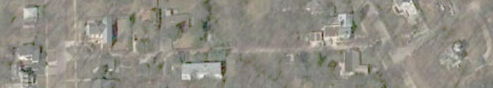
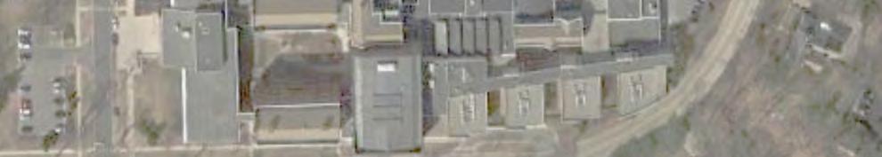
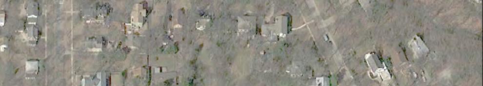
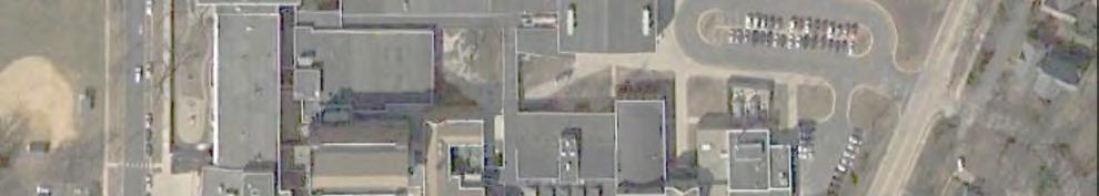
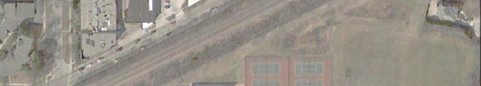
4 2 - EXISTING TRANSPORTATION NETWORK The existing transportation infrastructure serving the campus is provided by a combination of roadways, pedestrian walkways, bike paths, public transportation routes, and parking lots. Site Location and Area Land-Use Highland Park High School is located at 433 Vine Avenue between St Johns Avenue and the Robert McClory Bike Path. The main campus and school building is located north of Vine Avenue. Athletic fields and a visitor parking lot are located south of Vine Avenue. Land-uses around the campus are primarily single-family residential dwelling units to the north and east. Multi-family residents are located to the south. The Union Pacific North rail line (raised) and the bike trail are located along the west property line. The campus is located just north of Downtown Highland Park. Figure 1 shows the school location and area roadways immediately around the campus. Roadway Characteristics The following roadways are under the jurisdiction of the City of Highland Park except for Sheridan Road: Green Bay Road is a regional arterial roadway running through the North Shore suburbs along the Union Pacific Railroad North Line railroad tracks. At Vine Avenue and 1 st Street, Green Bay Road is signalized with crosswalks and pedestrian signals. The traffic signals for Green Bay Road, Vine Avenue, and 1 st Street operate as one signal. Southbound Green Bay Road has two approach lanes with a shared thru/left-turn lane and shared thru/right-turn lane. Northbound Green Bay Road has one thru lane at 1 st Street and at Vine Avenue. The posted speed limit is 30 miles per hour. St. Johns Avenue is a north-south residential collector road running south from Highwood past the campus, thru the Downtown to Ravinia Park. In front of the school, it has one travel lane in each direction. At Vine Avenue, St. Johns Avenue has an all-way stop controlled intersection. The posted speed limit is 25 miles per hour. In the Fall of 2014, a school speed zone was established on St John Avenue north of Vine Avenue. Vine Avenue is an east-west road running between Lake Michigan and the Exmoor Country Club. It is a residential collector street between St. Johns Avenue and Sheridan Road. It has one travel lane in each direction. Along the north side of the road, in front of the school building, a short-term parking/loading zone is provided. U-turns in front of the school are prohibited. The posted speed limit is 25 miles per hour. 1 st Street is a commercial street leading into Downtown Highland Park. It is signalized at its intersection with Green Bay Road and Vine Avenue. Parking is permitted on both sides of the street. The posted speed limit is 30 miles per hour. Woodpath Lane is a cul-de-sac residential street with nine homes under stop sign control opposite of the school bus drive on St. Johns Avenue. The speed limit is not posted. Bloom Street is an east-west two-lane street that extends from Oak Street to Green Bay Road. It has an overpass across the Union Pacific North Line railroad tracks. 3

5
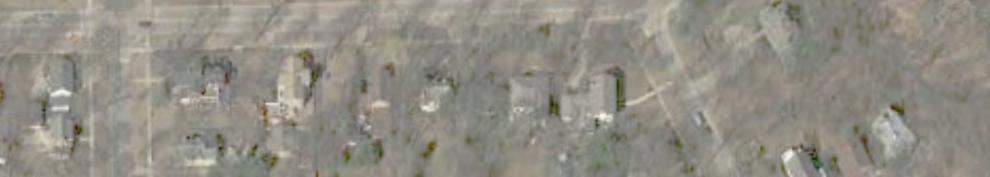
6 Sheridan Road is a north-south two lane arterial roadway with a 30 mile per hour (mph) speed limit and a School Speed Zone (20 mph). It is under the jurisdiction of the Illinois Department of Transportation but maintained by the City of Highland Park. South of Elm Place, the speed limit drops to 25 mph as it enters the Downtown district. No on-street parking is permitted north of Elm Place in front of the schools. South of Elm Place, there are marked on-street spaces. Elm Place is an east-west two lane road. It is one-way westbound between Linden Avenue and Sheridan Road. It has a combination of angled and parallel street parking on both sides. Maple Avenue is an east-west two-lane residential road extending east from St. Johns Avenue crossing Sheridan Road toward the lake. Public Transportation Public transportation at Highland Park High School is provided by a PACE bus route and a nearby Metra train station. PACE Route 472 runs along St. Johns Drive between Downtown Highland Park and the Metra Station past the school to Highwood and Ft. Sheridan. It has scheduled stops at the school on the northwest and southeast corners of Vine Avenue indicated by signs. Students were observed using the PACE buses but the number of students was very low. The bus stops consist of a sign on a post in the parkway. Students exit/enter the bus by walking over the grass parkway. Consideration should be given to construct a hard surface walkway and waiting area to better serve the students especially in the winter with snow on the ground. The Downtown Highland Park Metra train station on the Union Pacific North line is a 15 minute walk south of the school. Metra users have the option of walking or using the PACE bus to travel to the campus. School Bus Transportation Students can use the PACE bus route or District 113 school buses to travel to and from the campus. PACE Route 472 follows St. Johns Avenue with stops on the northwest (southbound) and southeast (northbound) corners of the Vine Avenue intersection. During the morning arrival period, five school buses arrive at 7:00 AM for the early bird routes and nine buses arrive at 7:50 AM for the regular start of school. In the afternoon, seven buses transport the students after dismissal at 3:15 PM. Additionally, two activity buses leave at 5:15 PM. Busses arrive via St. Johns or Vine Avenues to the bus only loading area opposite Woodpath Lane (see Figure 2). The loading area also has staff parking (51 spaces) so there an overlap in bus and staff traffic but it did not create any conflicts. The loading zone is approximately 460 feet in length which can accommodate up to 11 full size buses. The existing loading area and geometrics work well. Pedestrian and Bike Routes Pedestrian access is provided by sidewalks along the various streets around the campus and cross-walks at the major intersections. No sidewalk exists on the west side of St. Johns Avenue between Maple Avenue and the North student Lot access. Green Bay Road, Vine Avenue, and St. Johns Avenue are considered on-street bike routes near the Highland Park High School campus. The Robert McClory Bike Path is located along the west side of the campus. Figure 3 illustrates the existing pedestrian walks, bike routes, and crosswalk locations. 5


7
8
9 Student Loading Three loading areas are designated on-campus for student drop-off or pick-up and three informal loading areas are also being used. They are: North Student Lot (marked) West Staff Lot (marked) North side of Vine Avenue (marked) Vine Visitor Lot (informal) At the Vine Avenue/St. Johns intersection (informal) Vine Avenue East of St. Johns Avenue (informal) One location is on the north side of the building, in the student parking lot, east of the new gymnasium and north of the main building. Counts showed approximately 140 vehicles in the morning and 75 in the early afternoon using the loading zone. Parents enter the student parking lot, travel counter clockwise within the lot, drop-off/pick-up their student and continue counter clockwise to the student exit. Morning and afternoon observations showed the loading area working well. A second area is designated along the west side of the building, south of the athletic entrance with an entrance from Vine Avenue. This loading area is a mixture of curb loading (400 feet or 16 vehicles) and 17 spaces of diagonal parking spaces signed for a loading zone only. A truck dock is also located in this area. When a semi-truck is using the dock, it blocks the northbound direction but deliveries are scheduled to prevent conflicts. Observations during school hours indicate that this loading zone is used by 100 to 125 vehicles, has sufficient curb area, and works well. However, when traffic attempts to exit back onto Vine Avenue, it backs up and interferes with the loading activities. This will be discussed in more detail later in the report. A third drop-off area is located on the north side of Vine Avenue (westbound) in front of the school with 18 marked parking spaces that can be used by visitors outside of the peak arrival and dismissal periods. U-turns are prohibited from the westbound direction to eastbound Vine Avenue by signage. Only a couple of vehicles were observed making an illegal u-turn. Cars were observed parking across the marked crosswalk leading to the visitor lot. There are three unofficial loading zones near the school in the visitor lot, east of Vine Avenue, and on the approaches to the Vine and St. Johns intersection. Parents that do not want to travel westbound on Vine Avenue and go thru the Green Bay Road traffic signal, will pull into the visitor lot and drop-off their student in the lot and then exit back on eastbound Vine Street. Because the existing parking lot configuration is a single bay of parking, this activity (40-60 vehicles) requires the vehicles to back-up in order to turn around creating an unsafe condition. Another unofficial loading area used by parents to drop-off/pick-up their students while stopped at one of the Vine/St. Johns intersection stop signs and on Vine Avenue to the east. This activity needs to be discouraged since it creates delays and pedestrian/vehicular conflicts. Figure 4 shows the student loading flow paths. Student loading in front of existing neighbor s houses and driveways is a major complaint of the neighbors and contributes to congestion around the campus. 8
10
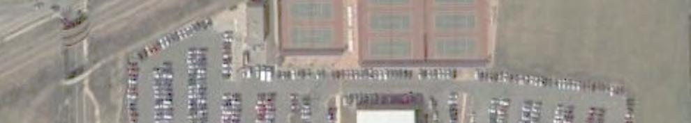
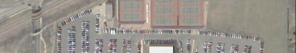
11 Parking Prior to the construction program, on-campus parking was provided in two staff lots, a student lot, and two visitor lots. Additional on-street parking for visitors was provided on the north side of Vine Avenue along the building s main entrance (See Figure 5). Overall, there are 613 spaces provided on the campus and 18 additional spaces along Vine Avenue. Table 1 summarizes the number of spaces by area and usage. Table 1 Highland Park High School Parking Supply and Usage Prior to 2014 Construction Vehicles Parked Lot Accessible Student Staff Visitor Total (8/27/2013) Student Staff/Bus Staff (1) Subtotal (94%) Visitor (Athletic) Visitor (Vine Lot) Visitor (Vine On-Street) Total (87%) (1) Includes spaces for school vans and drivers education vehicles Parking permits are issued to staff and students. After the morning arrival period, 537 parked vehicles were counted, without visitors, on campus. Please note that as the weather changes and more students obtain driver s licenses during the school year, the parking demand will increase. However, based on these counts Highland Park High School has sufficient parking for its day to day needs. Special events often require more parking than the campus supplies. For the school year, during the construction of the gymnasium and natatorium, the on-campus parking supply was reduced by 164 (-27%) spaces. Temporary remote parking lots were developed in conjunctions with the City of Highland to accommodate student parking at the St. Johns Metra lot, the 2 nd Street Public Lot, on-street parking on the east side of 1 st Street, and in the Moraine Park parking lot. These locations provided 86 additional parking spaces. The overall parking demand for the school dropped from 551 to 432 parked vehicles from the previous school year. The parking demand decrease corresponds to the increase in parent drop-off activity (50-75 vehicles). In the parent focus group discussion, parents expressed their concerns about remote parking locations and preference to take their kids to school rather than use remote parking. Part of this drop can also be attributed to not over selling the smaller student parking lot to avoid stranding students with parking permits. Table 2 summarizes the parking inventory and demand. 10
12 Table 2 Highland Park High School Parking Supply and Usage 2014 During Construction Vehicles Lot Accessible Student Staff Visitor Total Parked (9/2014) Student (37 staff) Staff/Bus Staff Visitor (Athletic) Visitor (Vine Lot) No Parking Permitted Fire Lane - Visitor (Vine On-Street) Remote Parking Lots St Johns Lot nd Street Lot Moraine Park st Avenue On-Street Subtotal (Student and Staff) (84%) Total 16 (-2) 240 (-41) 237 (-35) 42 (-18) 535 (-96) 432 (81%) 11

13
14 Data Collection Manual traffic counts of vehicles, pedestrians, and bicycles were conducted on a weekday during the morning (7:00 to 9:00 AM) and afternoon/evening (2:00 to 6:00 PM) peak periods around the campus to coincide with school arrival/dismissal periods and the peak hours of the surrounding street system. Counts were completed at: St. Johns Avenue/Vine Avenue St. Johns Avenue/Student Parking Lot St. Johns Avenue/Bus Loop and Woodpath Lane Vine Avenue/Green Bay Road 1 st Street/Green Bay Road Vine Avenue/Staff Parking Lot Vine Avenue/Visitor Parking Lot Elm Place and St. Johns Avenue Maple Avenue/St. Johns Counts were conducted at the beginning of the and the school years. The counts for the only covered the school peak-hours and did not include the evening commuter peakhour since they are not likely to change. Copies of the counts can be found in the Technical Appendix. Peak-Hours of Activity Three periods of peak activity were observed and indicated by the traffic counts. During the morning period, (7:00-9:00 PM), there was a combined peak of school related and commuter traffic from 7:00 to 8:00 AM. During the afternoon/early evening counts, (2:00 to 6:00 PM), there were two peaks periods. The first peak coincides with the school dismissal period and lasted from 3:00-4:00 PM. The evening commuter traffic period lasted from 4:30 to 5:30 PM. The results of the vehicular, pedestrian and bike counts are shown in Figures 6 and 7 for school year and Figures 8 and 9 for the school year. 13
15
16
17
18
19 Existing Intersection Capacity Analyses Intersection capacity analyses were conducted with the proposed and nearby developments included. Tables 3 shows the future level of service and delay results for the total traffic conditions. Overall, each intersection works well for each peak-hour based on the capacity analyses. The North Lot driveway has geometric deficiencies as previously described which results in more congestion than indicated by the analyses. The traffic signal at Green Bay Road and Vine Avenue/1 st Street overall works at an acceptable level of service C or D during the peaks. In the morning and afternoon school peaks, westbound Vine Avenue frequently blocks the west entrance the west entrance to the school. Southbound right-turn traffic exiting the school can t turn right and stacks in the entrance. This queue also encourages parent traffic top pull into the visitor lot to drop-off/pick-up their students and turn back east to avoid the back up. Table 3 Intersection Level of Service Intersection AM School/ Commuter Peak PM School Peak PM Commuter Peak 7:00-8:00 AM 3:00-4:00 PM 4:30-5:30 PM St. Johns Avenue at: North Student Lot Drive 3 LOS- A LOS- A LOS- A Bus Loop and Woodpath Lane 3 LOS- A LOS- A LOS- A Vine Avenue at: Vine Avenue 2 LOS- B LOS- A LOS- A Visitors Lot 2 LOS- A LOS- A LOS- A Staff/Student Drive 2 LOS- B LOS- A LOS- A Green Bay Road 1 LOS- C LOS- D LOS- D Green Bay Road at 1st Street 1 LOS- C LOS- D LOS- D 1- Traffic Signal 2- All-Way-Stop 3- Two-Way Stop 19
20 3 CAMPUS TRAVEL CHARACTERISTICS This chapter describes how students travel to the campus Campus Site Traffic Volumes The traffic counts from the 2013 were compared to the 2014 traffic data to determine the amount of traffic going to and from the campus. Please note that the number of school and PACE buses did not change. Table 4 shows the traffic counts in and out of the school driveways, the Vine Avenue loading area, and the remote parking lots (2014 only). Table 4 Comparison of AM Peak-Hour Traffic Volumes Going To and From Highland Park High School 2013 Hourly Volumes 2014 Hourly Volumes Percent Access In Out Total In Out Total Change North Lot % Bus Lot % Vine Drive % Vine Loading % Visitor Lot % Remote Lots (4) Total % Student Population 2,127 2,076-2% Drive and Drop % Drive and Park % Overall, while the student population dropped (-2%), the total traffic volumes increased (+8%). Traffic at the bus lot did drop with a staff member there to keep out parent traffic. Student vehicles driving to the campus (including the remote lots) went up slightly. As shown, there was major growth in parent pick-up and drop-off traffic (+9%) at the Visitor Lot, the North Student Lot, and the Vine Loading area. The Vine West Drive did not see a major change in traffic volumes. Student Travel Modes Using the 2013 and 2014 data on vehicular, pedestrian, and biking volumes along with daily school bus usage data, an estimate was made on the number of students using different travel modes which is summarized in Table 5. 20
21 Table and 2014 Student Mode of Transportation Travel Mode National Average Number of Students % Number of Students % Change Walk/Bike (1) 7.5% % % +16% School Bus 25.9% % % +38% Drive and Park Parent Drop-off and Pick-Up 62.1% % % -21% % % -5% Metra/PACE 4.5% 10 (2) <1% 10 <1% - Total 100% 2, % 2, % (1) Including students who park in the neighborhood or are dropped off near the school and walked. (2) Students usage of Metra/PACE does occur but is minimal As shown above, the number of students walking/biking and using the bus has increased from the previous school year. The number of students driving and parking has decreased 21%, even with the provision of remote parking locations. The number of students who were dropped off had decreased slightly from the year before (39% to 37%). However, as noted in the previous section, more parent vehicles were driven to the campus. Exact numbers are not available for the school staff but based on the parking counts, more than 90% of the staff drive and park at the school campus. Anecdotal evidence shows that staff also uses Metra and PACE. 21
22 4 - BUILDING PROGRAM School District 113 began developing a Long Range Facility Master Plan for Deerfield and Highland Park High Schools in May, The goal was "to create facilities that foster educational excellence while respecting the District's taxpayers." By 2012, School District 113 developed a five year Capital Development Plan for Highland Park and Deerfield High Schools. The plan called for building improvements to security, HVAC, water, class rooms, fire protection, windows, and other infrastructure improvements. Each school will expand their physical education facilities with an additional gymnasium and a pool. The building program at Highland Park High School will add additional program space and classroom for existing students and staff. Traffic volumes and parking demand at Highland Park High School will not increase as a result of these additions or improvements. Figure 10 illustrates the proposed site plan presented in the spring of The major changes to the campus site circulation and parking with the proposed plan are: 1. The parking lots are modified to accommodate an additional gymnasium and pool. 2. The north soccer field is moved to the west to create replacement student parking. 3. The Vine Street parking lot is increased to offset parking lost in other portions of the campus. The plan as shown was substantially approved by the City of Highlands Park with the exception of the expanded visitor lot at the southwest corner of Vine and St. John Avenue. Table 6 shows the parking supply before, during construction, and proposed at the campus. Table 6 Highland Park High School Parking Supply 2014 Lot 2013 Construction Proposed Accessible Student Staff Visitor (Off Street) Visitor (On-Street) Student (Remote) Total


23
24 5 PARKING The original intent of the campus improvement was not to change the total parking supply of 631 spaces on the campus. The staff parking in the bus lot did not change. With the removal of the on-street visitor parking along Vine Avenue, 18 spaces were lost at the campus. With the proposed gymnasium and pool buildings, the student and staff lots would have a net reduction of 86 spaces (50 spaces in the student lot and 36 spaces in the staff lot). These reductions are offset by an increase of 86 spaces in the Vine Street Visitor lot. During the Plan Commission review process, city staff suggested additional parking but the District 113 did not concur. One of the outcomes of the focus groups was the existing student parking in the neighborhood where local residents rent them spaces. This activity further reinforces the need for more parking on the campus. Based on the review of the existing parking conditions, there is a need for additional parking on the campus. With the demand for parking in the neighborhood, the overselling of parking spaces, and juniors requesting but not receiving permits. The additional parking needed would be in the range of 70 to 100 spaces assuming no changes in the travel behavior of students and staff. Increases in carpooling, school bus usage, walking, and biking will mitigate part of this additional need. Parking Alternatives A number of parking alternatives were developed for the campus by the District 113 staff, advisory committee, and project team resulting in more than 150 possible combinations and impacts. A number of alternatives were quickly eliminated because they did not provide enough parking or provided more than 631 spaces. The remaining alternatives were then vetted on their impact on traffic, the neighbors, cost, athletic fields, and student loading operations. Based on the analyses two changes were proposed. One was to expand the Athletic Lot to 239 spaces and to reduce the Vine Street Lot to 115 spaces. The north student lot still provides the majority of the student parking, 232 spaces, with 56 spaces to be located in the existing athletic lot, south of the pool building. Approximately 70 staff will be relocated in the expanded Vine Street lot due to the relocation of student spaces. Table 7 summarizes the revised parking totals by area and classification. Table 7 Proposed Parking Supply and Usage Lot Accessible Student Staff Visitor Total Student Staff/Bus Athletic Vine Lot Total Please note that the Vine Lot will be for staff and visitor parking. No students will be allowed to park in the lot. Staff traffic volumes mostly occur before or after the peak student traffic periods. 24
25 Structured Parking Structured parking generally costs between $15,000 and $20,000 per parking space. A 130 space parking garage would cost $1,950,000 to $2,600,000. While a garage could be developed in the northwest portion of the campus, budgetary concerns eliminated this option early in the site planning process. Permanent Remote Parking The temporary remote parking plan for Highland Park High School was implemented the school year at four locations. The anticipated benefits of remote parking were a reduction in traffic around the school and less parking needed on the campus. However, traffic to and from the campus increased by 8%. Remote parking did not provide the anticipated reduction in congestion around the high school campus. In fact, it increased congestion. This is consistent with the feedback from two of the focus groups prior to its implementation. Surface Parking at the Tennis Courts or Athletic Fields Creating additional parking on-campus north of Vine Avenue will add more traffic to the two high school driveways on Vine Avenue and St. Johns Avenue maintaining the existing congestion at those drives. Parking lots will require the relocation of athletic facilities and activities at an additional cost. 25
26 5 VINE AVENUE ONE-WAY This chapter discusses the impact of making Vine Avenue one-way eastbound or westbound near the high school to improve overall vehicular traffic flow and safety. Making Vine Avenue one-way in front of the Highland Park High School would improve traffic in front of the school but will shift the congestion from one location to another and have safety implications at the signalized intersection, increased pedestrian conflicts, and additional train and vehicular conflicts. Previous Study In 2006, CivilTech Engineering reviewed the possibility of making Vine Avenue one-way during the arrival and dismissal periods to simplify and improve traffic flow. They concluded: While this change would benefit the intersection of Vine/Green Bay and First Street, the impact would be negative on other nearby intersections, particularly at Green Bay and Elm Place, which is signalized, and First Street and Elm Place and Green Bay and Bloom, which are not signalized intersections. Furthermore, loading and unloading passengers into a traffic lane presents a safety problem and is not recommended. Vine One-Way Westbound One concept was to make Vine Avenue one-way westbound from Green Bay Road to St. Johns Avenue along the south side of the school. Student loading will still occur, as it does today, on the north side of Vine Avenue. Traffic at the visitor parking lot would be left-in and -out only. The West Vine school drive would then be right-in and out only. At Green Bay Road, Vine Avenue could use the existing two lanes, a left-turn lane and a shared thru/right-turn lane to create more capacity at the traffic signal. The potential benefits of the configuration are: Increased capacity for westbound Vine Avenue at the Green Bay Road traffic signal with two lanes versus one lane. Simplified flows in and out of the school driveways. Elimination of the eastbound left-turn blockage at the west drive. Keep student loading along the school frontage. One-way designation would only occur during school hours (6:00 AM to 4:00 PM) The traffic signal at Green Bay/Vine/1st would have to be rebuilt with special signal heads and signage to support the one-way restrictions ($2-300,000). For example, the traffic signal would have no left, thru, or right-arrows to be used on school days for traffic heading east on Vine Avenue. Restricting the northbound right, eastbound through, and southbound left-turn movements is further complicated by each of those movements since they share a lane with other traffic movements. For example the eastbound approach lane also serves right and left-turn movements. Due to the curves in Green Bay Road advance warning would be needed. EEA reassigned the existing (2013) Vine Avenue and school traffic volumes based on Vine Avenue being one-way westbound. Most high school traffic comes from the south and west. Most of the traffic that was eastbound on Vine Avenue would go eastbound on Elm Place then north on St. Johns Avenue to westbound Vine Avenue. There would be minimal usage of Bloom since drivers would have to go north and then go south (roughly 1.5 miles vs 0.15 miles) to get back to the school. Figure 11 shows the total one-way west bound traffic volumes. 26


27
28 The change to a one-way road results in a drop in the morning peak-hour in traffic volume at the Green Bay signalized intersection with a corresponding traffic increase at Elm Place and St Johns (See Table 8). Table 8 Change in AM Peak Traffic Volumes Vine One-way Westbound Intersection Vine Existing Westbound % Change Hourly Volume Green Bay/Vine Avenue 1,467 1,035-30% Elm Place/St. John Avenue 776 1, % St. John Avenue/Vine Avenue % The Vine Street lot access and the West Vine Access will operate better under a one-way system as would as the intersection of Green Bay Road at Vine Avenue/1 st Street. However, the AWSC intersections on St Johns Avenue and Elm Place will see more congestion. With the additional eastbound traffic on Elm Place, the west leg will operate at LOS F and back-up across the railroad tracks. Table 9 Vine Avenue Westbound Intersection Level of Service and Delay Intersection Existing Vine One- Way Westbound 7:00-8:00 AM 7:00-8:00 AM Green Bay/Vine Avenue LOS- C 29.6 LOS- B Elm Place/St. John Avenue LOS- B 13.4 LOS- E 37.2 St. John Avenue/Vine Avenue LOS- B 10.5 LOS- C
29 Based on this analysis, there will be several negative impacts with Vine as a one-way street westbound: 1. Increased traffic on St. Johns Avenue and Elm Place. 2. More congestion on the east side of the campus. 3. From 7:00 to 8:00 AM, there are at least five trains crossing the railroad tracks on Elm Place impacting the traffic flow to the school. If each cycle of the gate closure is approximately three minutes long, 15 minutes or 25% of the roadway capacity is lost. 4. Additional school traffic at an at-grade rail crossing is not as safe as a grade separated crossing. 5. There will be more traffic (256 vehicles in the morning) traveling past Indian Trail Elementary School s access drives thereby creating more conflicts. 6. Changes at the Green Bay/1 st /Vine traffic signal will require it to be rebuilt. 7. Creates traffic safety concerns due to driver confusion when a traffic signal permits restricts certain movements for several hours during the school day and not on other days. 8. Additional westbound traffic will use the loading zone along Vine Avenue in front of the school causing more back-ups into the Vine/St. Johns intersection. Vine One-Way Eastbound The second concept is to make Vine Avenue one-way eastbound from Green Bay Road to St. Johns Avenue. Student loading would have to occur on the south side of Vine Avenue. Traffic at the visitor parking lot would be right-in and right-out only. The West Vine school drive would then be left-in and out only. At Green Bay Road, Vine Avenue westbound would not be used. The potential benefits of the configuration are: Increased capacity for eastbound Vine Avenue at the Green Bay Road traffic signal. Simplified flows in and out of the school driveways. Elimination of the eastbound left-turn blockage at the west drive. One-way designation would only occur during school hours (6:00 AM to 4:00 PM) EEA reassigned the existing (2013) Vine Avenue and school traffic volumes based on Vine Avenue as one-way westbound. Most high school traffic comes from the south and west of the high school. Most of the traffic that was westbound on Vine Avenue would go eastbound on Vine Avenue to south on St. Johns Avenue to westbound on Elm Place. There would be minimal usage of Bloom since drivers would have to go north and then go south (roughly 1.5 miles vs.15 miles) back to the school. The traffic volumes are not shown but the results are very similar to the westbound only Vine Avenue alternative. Traffic would increase along St Johns Avenue and decrease at the traffic signal. 29
30 Vine Avenue one-way eastbound will have several negative impacts: 1. Increased traffic on St. Johns Avenue. 2. More congestion on the east side of the campus. 3. From 7:00 to 8:00 AM, there are at least five trains crossing the railroad tracks on Elm Place impacting the traffic flow to the school. If each cycle of the gate closure is approximately three minutes, 25% of the roadway capacity is lost. 4. Additional traffic at the at-grade rail crossing is not as safe as a grade separated crossing. 5. More traffic will travel past Indian Trail Elementary School s access drives creating more conflicts. 6. Changes at the Green Bay/1st/Vine traffic signal would be required but not as extensive as the westbound alternative. 7. Dropping off students on the south side would add approximately 150 to 200 more students crossing Vine Avenue. Ideally, they would cross at a designated crossing. Experience at other high schools indicates that crossings at multiple locations will occur. 8. A sidewalk along the curb would be required with accessible ramps at the west end to accommodate the grade changes. Impact on Emergency Services Preliminary discussions with the City of Highland Park Police and Fire Departments indicated that a oneway system would negatively impact response to calls at the high school and northeast portion of the City by restricting one of the few grade separated crossing of the train tracks in the City of Highland Park. Also, the addition of several hundred cars at the Elm Place crossing could slow emergency response to the Indian Trail and Elm Place schools during peak travel times. Turn Restrictions and One-Way Traffic Flow on Campus Additional alternatives were analyzed with various turn restrictions at the Athletic and Student Lot entrances or making traffic flow through the campus one-way northbound (entering on Vine and exiting on St. Johns) to improve overall traffic flow. However, similar to making Vine Street one-way, school traffic was diverted to alternate routes and causing more congestion/safety issues at other locations. For example, the southbound traffic turning right into the student lot in the morning is 203 vehicles per hour. Under the one-way through the campus scenario, these volumes would be diverted to the southbound left-turn on Green Bay Road or the St. Johns/Vine intersection and increasing the congestions at each intersection. Another example is restricting left-turns into the Athletic Lot would reroute traffic to Elm Place and the St. Johns/Vine intersection and increase congestion there. Summary Based on the above review, making Vine Avenue one-way in front of the Highland Park High School would improve traffic in front of the school but will shift the congestion from one location to another and have safety implications at the signalized intersection, increased pedestrian conflicts, and additional train and vehicular conflicts. Other alternatives resulting in turn restrictions will have similar impacts. 30
31 6 - STUDENT LOADING As previously mentioned, there are three marked and two informal loading areas around the campus. They are: North Student Lot (marked) West Staff Lot (marked) North side of Vine Avenue (marked) Vine Visitor Lot (informal) At the Vine Avenue/St. Johns intersection and to the east (informal) In the newly constructed north student lot, the loading area has been increased. The west and south side of the lot now provides loading zones by the gym entrance (west) and the north building entrance (south). When combined, the two loading areas provide capacity for 17 vehicles (340 feet). The loading zone works well today. Access into and out of the lot will be addressed later in this report. The west staff lot has a loading zone by the athletic entrance and the library entrance. Entering and exiting the loading area is congested due to back-ups from Vine and the Green Bay Road traffic signal. Prior to the school years, the loading area along the north side of Vine Avenue (450 feet long) provided 18 visitor spaces. These spaces have been removed for a designated fire lane. In the current configuration, school staff has been monitoring the loading which has improved its operations. However, back-ups are continuing to interfere with the Vine Avenue and St. John Avenue intersection. Parents are have been using Vine Avenue east of St. Johns as an over flow loading area. Based on the prior review, making Vine Avenue one-way in front of the Highland Park High School would improve traffic in front of the school but will shift the congestion from one location to another and have safety implications at the signalized intersection, increased pedestrian conflicts, and additional train and vehicular conflicts. An option is to create another loading area(s) to reduce activity in front of the school and neighbor residences. Alternate locations would also be used to eliminate or minimize the traffic congestion and safety concerns. Several new loading options were considered at other locations. On-street loading areas were considered along the south side of Vine Avenue and the west side of St. Johns Avenue. Due to the road curvature and terrain, St. Johns Avenue will not be a safe area for a loading zone. Dropping off students on the south side of Vine Street would add approximately 150 to 200 more students crossing Vine Avenue. Southbound traffic could back-up into the St Johns/Vine intersection. Ideally, they would cross at a designated crossing. Experience at other high schools indicates that crossings at multiple locations will occur. These options are not safe. Additional on-campus loading was improved by reconfiguring the athletic lot to add additional parking and provided more queuing space for the exiting traffic. Additional spaces is provided for 15 vehicle which allows parents to drop-off their student and then get out of the loading zone while waiting to turn onto Vine Street. This will minimize any inbound backups that block Vine Street. Figure 12 illustrates the proposed lot configuration. 31

32
33 South of Vine Avenue, the redesign of the visitor lot replaces off-street parking spaces lost to the north and creates a one-way circulation pattern within the lot for parents dropping-off or picking-up their students. These parking spaces will designated for staff parking, which have arrive before or depart after the peak student travel times. Access would be on Vine Avenue (right-in only) and right-out access onto St. Johns Avenue before or after school. Other times of the day, the Vine Avenue access could remain as full access for visitor traffic. A school staff member currently monitors the access drive and will continue to do so in the future. School traffic eastbound on Vine Avenue would turn right-in the lot, travel counter clockwise, drop-off/pick-up their student and then exit on St Johns Avenue and avoid the Vine Avenue intersection. Figure 13 illustrates the lot layout. Student loading will occur on the north side of the lot and west of the access drive. There are approximately 14 parking spaces that will be reserved for visitors with parking prohibited during arrival and dismissal which was similar to the original operation of the Vine Avenue on-street visitor parking spaces. Students will exit the vehicle and be directed to the existing crosswalk on Vine Avenue. A fence or other barrier will be located between the parking lot and the Vine Avenue to direct students to the crosswalk. During the afternoon dismissal, parent traffic will be able to queue in the drive aisle of the lot. The expanded lot will provide additional off-street loading capacity and give eastbound Vine Avenue traffic an alternate loading location to the athletic lot. As previously mentioned, if the athletic loading area backs up to Vine Avenue, parents can be directed by a staff member to continue onto the Vine Avenue lot and not block traffic. In the past, U-turns have been a problem in the past when impatient parents cannot go into the athletic lot so they went past and turned around to drop-off their student. Signage has been posted prohibiting U-turns which remain in place. Summary The three marked loading zones currently cannot handle the total volume of drop-off traffic at Highland Park High School. As a result, parents are using the Vine Avenue visitor lot and the Vine/St. Johns intersection to drop off students. Neighbors have noted that parents are also using their driveways as loading areas. Additional loading zone capacity in the Athletic and Vine Street Lots will move congestion off the public street system. 33

34
35 7 - INTERSECTION ANALYSES North Student Lot Driveway The entry to the North Student Lot from St. Johns Avenue has one inbound lane and two outbound lanes (right and left) under stop sign control. St. Johns Avenue has one lane in each direction without turn lanes. Capacity analyses indicated that this entrance should work better than what has been observed in the field. The driveway has a very tight turning radius on the southwest corner (2-3 feet) for right-turns in and 10 foot radius on the southeast corner for right-turns out. Also, the drive is not perpendicular to St. Johns Drive and has a curved approach. As a result, vehicles turning in and out of the driveway have overlapping turning paths that slow or stop the flow of traffic. This causes traffic back-ups for left turning traffic into and out of the parking lot. The driveway should be improved to accommodate the turning paths without overlap with a wider width and turning radi. This will improve vehicle safety and intersection capacity. This intersection does not meet the minimum warrants for an All Way Stop Controlled (AWSC) intersection or a traffic signal. A traffic warrant is the minimum requirement needed to install a stop sign or traffic signal based on various criteria such as traffic volumes, crash reduction, and pedestrian protection. The minimum traffic or pedestrian volumes are not met for a traffic signal or an AWSC intersection. Putting stop signs on northbound and southbound St. Johns Avenue, which are only needed for 30 minutes in the morning and in the afternoon, will cause more traffic delays throughout the day. Also, with school in session for part of the year, drivers will be inclined to roll through the stop and cause other safety problems. The same problems will occur at a traffic signal that is only needed for short periods of time. School staff is now stationed at this intersection during morning peak times to help direct traffic which improves the flow. In lieu of full time traffic control, a school staff member has been directing traffic at the intersection starting in the Fall of 2014 and has improved the traffic flow. Vine Avenue and the Athletic Lot Drive This driveway at Vine Avenue will not be modified and will retain its one inbound and two (right and left) outbound lanes. With the redesign of the parking, the lot will have 37 more spaces and reroute the exiting traffic thru the lot to the exit. The benefit of this design is preventing exiting traffic from blocking the loading area and queuing onto Vine Avenue. A school staff member has been directing traffic at the intersection starting in the Fall of 2014 and has improved the traffic flow. Vine Avenue Access The existing driveway on Vine Avenue will serve the expanded staff and visitor lot. During peak arrival and dismissal time, the drive will be right-turn in only (eastbound) with no left-turns or right-out permitted. It will be enforced by the staff member currently at the drive this school year. Drivers will turn right into the driveway and circulate counter-clockwise through the lot. A designated location for drop-off is located in the northwest section of the lot. A fence will direct students to the existing crossing location to the high school. Since the drive will be right-turn only, traffic will move freely. With a loading zone and parking lot south of Vine Avenue, a right-turn in only could be developed to allow eastbound traffic to enter. Exiting traffic would use a new access point on St. Johns Avenue and avoid the AWSC intersection. 35
36 Students will use the Vine Avenue crosswalk west of the lot entrance. With the revised traffic pattern, the volume of morning traffic will drop by 73 vehicles per hour. This will improve vehicle delays by 10% with the reduction in volume and even more with the reduce drop-off congestion. The right-out only will slightly increase traffic southbound on St Johns Avenue. Revised traffic volumes are shown in Figure 14. Vine Avenue and St. Johns Avenue Parents have been observed dropping-off/picking-up their students while stopped at one of the Vine/St. Johns intersection stop signs. The student then goes thru the parkway to the sidewalk. This activity needs to be discouraged since it creates delays and pedestrian/vehicular conflicts. Signage, police enforcement, and reminders to the parents have been provided during the beginning of the 2014 school year which has reduced this activity. This intersection does not meet the warrants for a traffic signal which require a minimum of 500 to 1,000 vehicles per hour on one of the two streets. Neither street comes close to these volume levels. Neighborhood Driveway Usage Communication and periodic police enforcement is needed to discourage parents from pulling into neighbors driveways to get their students. Improvements to the loading procedures, including the Vine Avenue lot, would minimize this activity. Vine Avenue and Sheridan Road The intersection of Vine Avenue with Sheridan Road is located about 700 feet east of St. Johns Avenue. Both roads have one lane in each direction. Stop signs are located on the Vine Avenue approaches with crosswalks on all four legs. Sheridan Road has a 30 mph speed limit. A crossing guard is located at this intersection for students at Indian Trails Elementary and Elm Place Middle schools. Some delays are created at the intersection when the crossing guard stops traffic for crossings. When school traffic is congested, backups along Vine Avenue can impact Sheridan Road. However, with the proposed improvements around the high school, theses impacts should be minimized. Vine Avenue at Green Bay Road and 1 st Street Overall, both intersections operate with a good level of service. In the morning and afternoon school peaks, westbound Vine Avenue periodically backs up from the traffic signal and blocks the west entrance to the school. Southbound right-turn traffic exiting the school can t turn right and stacks in the entrance. Additional green time for the Vine Avenue would help reduce this queue during the peak school hours without significantly impacting Green Bay Road traffic. It is recommended that the green time be increased from 35 to 45 seconds. Capacity analyses in the appendix show the revised timings. The City of Highland Park long range plan is to create two separate traffic signals serving Vine Avenue and 1 st Street individually instead of one large signalized intersection on Green Bay Avenue. The benefit of the improvement is shorter clearance times (yellow and all-red) creating more green time for traffic. No time frame has been developed for this improvement. Proposed Dunkin Donuts A Dunkin Donuts with a drive-thru window and other retail spaces has received approval at the southeast corner of Green Bay Road and Park Avenue. That site is currently occupied by a Mobil gas station. At the request of the community, EEA obtained a copy of the traffic study to determine the potential impact on traffic conditions near the high school. 36
37 The proposed Dunkin Donuts store is located about one quarter mile south of Vine Avenue on Green Bay Road. It is replacing an existing Mobil gas station. A traffic study by Gewalt-Hamilton Associates, dated May 12, 2014, shows a net increase in traffic of 5 to 10 vehicles per hour on Green Bay Road to the north. This net increase accounts for the existing traffic at the Mobil gas station and that the majority of the Dunkin Donuts traffic is by-pass traffic. Bypass traffic is existing vehicles that will stop at the Dunkin Donuts on their way to work, the train, or school. As a result the growth in new traffic is minimal. Traffic from the proposed Dunkin Donuts store will not have an impact on the high school traffic flows. Linden Avenue Linden Avenue is a north-south collector road between Lake Michigan and Downtown Highland Park. It is used as an approach route to the high school for the neighborhoods to the southeast. The alternative route is to take Sheridan Road/St. Johns Avenue through the Downtown area which is impacted by the train crossings. Since Linden Avenue is a designated collector road, it is not unreasonable for school traffic to use it to avoid traffic congestion in the downtown area. In fact, three schools have traffic using Linden Avenue; Highland Park High School, Elm Place School, and Indian Trail School. Please note that the North Shore School District 112 is considering changes to their Indian Trail and Elm Place schools that may lessen the traffic volumes on Linden Avenue. Specific traffic issues were not mentioned in a resident s letter so EEA suggests that the Police Department monitor the travel speeds to verify if Linden Avenue warrants additional speed control. North Shore School District 112 North Shore School District is currently going through a long-term analysis of their district including consolidating some of their facilities. Some of the scenarios involve the Indian Trail and Elm Place school campuses. There are opportunities for the two districts to work together to improve the traffic conditions where the schools traffic over lap. This opportunity will take several years to review and implement. 37

38
Traffic Circulation & Pedestrian Safety Study
 Lyons Township High School North Campus La Grange, Illinois Parking Lot Vaughan Building N Main Building Prepared for: Prepared by: July 23, 2015 Contents List of Figures, iii 1. Introduction...1 2. Existing
Arlington Public Schools Thomas Jefferson Site Evaluation Transportation Networks. Thomas Jefferson Working Group Meeting #6 November 10, 2014
 Arlington Public Schools Thomas Jefferson Site Evaluation Transportation Networks Thomas Jefferson Working Group Meeting #6 November 10, 2014 2 3 INTRODUCTION 4 Goal of our work: Identify and assess multi-modal
Traffic Study North Shore School District 112
 Traffic Study North Shore School District 112 Proposed Expansion of Northwood Junior High School Prepared By: May 1, 2015 1. Introduction Kenig, Lindgren, O Hara, Aboona, Inc. (KLOA, Inc.) has been retained
Hidden Oaks Elementary School
 Hidden Oaks Elementary School SCHOOL ROUTE PLAN For HIDDEN OAKS ELEMENTARY SCHOOL LOCATION 13 ORANGE COUNTY Prepared for: ORANGE COUNTY SCHOOL ASSESSMENT PROGRAM ORANGE COUNTY PUBLIC WORKS Traffic Engineering
Corporate. Report COUNCIL DATE: May 25, 1998 NO: R1500 REGULAR COUNCIL. TO: Mayor & Council DATE: April 27, 1998
 R1500 : Traffic Safety at 25 Avenue and 128 Street Intersection Corporate NO: R1500 Report COUNCIL DATE: May 25, 1998 REGULAR COUNCIL TO: Mayor & Council DATE: April 27, 1998 FROM: General Manager, Engineering
Lake Whitney Elementary School
 Lake Whitney Elementary School SCHOOL ROUTE PLAN For LAKE WHITNEY ELEMENTARY SCHOOL LOCATION 18 ORANGE COUNTY Prepared for: ORANGE COUNTY SCHOOL ASSESSMENT PROGRAM ORANGE COUNTY PUBLIC WORKS Traffic Engineering
Drag and drop pic and stretch/crop to the limits of the blue rectangle (delete this text box) Maxey Elementary School
 Maxey Elementary School") Drag and drop pic and stretch/crop to the limits of the blue rectangle (delete this text box) Maxey Elementary School SCHOOL ROUTE PLAN For MAXEY ELEMENTARY SCHOOL LOCATION 33 ORANGE COUNTY Prepared for:
Drag and drop pic and stretch/crop to the limits of the blue rectangle (delete this text box) Maxey Elementary School SCHOOL ROUTE PLAN For MAXEY ELEMENTARY SCHOOL LOCATION 33 ORANGE COUNTY Prepared for:
Traffic Circulation Study for Neighborhood Southwest of Mockingbird Lane and Airline Road, Highland Park, Texas
 ARIZONA TEXAS NEW MEXICO OKLAHOMA February 13, 2015 Mr. Meran Dadgostar P.E., R.S. Town of Highland Park 4700 Drexel Dr. Highland Park, Texas 75205 Re: Traffic Circulation Study for Neighborhood Southwest
Memorandum. Sunday, July 13, Saturday, July 19, 2014
 Memorandum To: David Lowin, Brooklyn Bridge Park Corporation From: Daniel Schack, AICP, PTP Date: Re: Brooklyn Bridge Park Pier 5/6 Loop Road Traffic Study Project No: 14-01-2407 At the request of Brooklyn
Windy Ridge Elementary School
 Windy Ridge Elementary School SCHOOL ROUTE PLAN For WINDY RIDGE ELEMENTARY SCHOOL LOCATION 54 ORANGE COUNTY Prepared for: ORANGE COUNTY SCHOOL ASSESSMENT PROGRAM ORANGE COUNTY PUBLIC WORKS Traffic Engineering
Meadow Woods Elementary School
 Drag and drop pic and stretch/crop to the limits of the blue rectangle (delete this text box) Meadow Woods Elementary School Drag and drop pic and stretch/crop to the limits of the blue rectangle (delete
Shockoe Bottom Preliminary Traffic and Parking Analysis
 Shockoe Bottom Preliminary Traffic and Parking Analysis Richmond, Virginia August 14, 2013 Prepared For City of Richmond Department of Public Works Prepared By 1001 Boulders Pkwy Suite 300, Richmond, VA
Transportation Impact Study for Abington Terrace
 Transportation Impact Study for Abington Terrace Abington Township, Montgomery County, PA Sandy A. Koza, P.E., PTOE PA PE License Number PE059911 Prepared by McMahon Associates, Inc. 425 Commerce Drive,
Magnolia Place. Traffic Impact Analysis. Prepared for: City of San Mateo. Prepared by: Hexagon Transportation Consultants, Inc.
 Magnolia Place Traffic Impact Analysis Prepared for: City of San Mateo Prepared by: Hexagon Transportation Consultants, Inc. Updated January 4, 2010 Table of Contents 1. Introduction...1 2. Existing Conditions...6
Orange Center Elementary School
 Drag and drop pic and stretch/crop to the limits of the blue rectangle (delete this text box) Orange Center Elementary School Drag and drop pic and stretch/crop to the limits of the blue rectangle (delete
TRAFFIC IMPACT ANALYSIS
 TRAFFIC IMPACT ANALYSIS FOR THE CHAMPAIGN UNIT#4 SCHOOL DISTRICT PROPOSED HIGH SCHOOL (SPALDING PARK SITE) IN THE CITY OF CHAMPAIGN Final Report Champaign Urbana Urbanized Area Transportation Study 6/24/2014
Harrah s Station Square Casino
 Transportation Analysis Harrah s Station Square Casino Pittsburgh, Pennsylvania Submitted To: City of Pittsburgh and Pennsylvania Gaming Control Board Prepared By: DKS Associates GAI Consultants December
ALLEY 24 TRAFFIC STUDY
 ALLEY 24 TRAFFIC STUDY in City of Frostburg, Maryland January 2013 3566 Teays Valley Road Hurricane, WV Office: (304) 397-5508 www.denniscorporation.com Alley 24 Traffic Study January 2013 Frostburg, Maryland
Appendix C. NORTH METRO STATION AREA TRAFFIC IMPACT STATEMENT 88th Avenue Station
 Appendix C NORTH METRO STATION AREA TRAFFIC IMPACT STATEMENT 88th Avenue Station Prepared for: Regional Transportation Department and URS Corporation as part of the North Metro EIS David Evans and Associates,
4. ENVIRONMENTAL IMPACT ANALYSIS 9. TRANSPORTATION AND TRAFFIC
 4. ENVIRONMENTAL IMPACT ANALYSIS 9. TRANSPORTATION AND TRAFFIC 4.9.1 INTRODUCTION The following section addresses the Proposed Project s impact on transportation and traffic based on the Traffic Study
VIVA RETIREMENT COMMUNITIES OAKVILLE TRAFFIC IMPACT STUDY
 VIVA RETIREMENT COMMUNITIES OAKVILLE TRAFFIC IMPACT STUDY VIVA RETIREMENT COMMUNITIES OAKVILLE TRAFFIC IMPACT STUDY DECEMBER 2012 READ, VOORHEES & ASSOCIATES TORONTO, ONTARIO Read, Voorhees & Associates
9 Leeming Drive Redevelopment Ottawa, ON Transportation Brief. Prepared By: Stantec Consulting Ltd.
 9 Leeming Drive Redevelopment Ottawa, ON Transportation Brief Prepared By: Stantec Consulting Ltd. TIA GUIDELINES CHECKLIST Report Context Municipal Address Comment: Section 1.1 Location relative to major
METHODOLOGY. Signalized Intersection Average Control Delay (sec/veh)
") Chapter 5 Traffic Analysis 5.1 SUMMARY US /West 6 th Street assumes a unique role in the Lawrence Douglas County transportation system. This principal arterial street currently conveys commuter traffic
Chapter 5 Traffic Analysis 5.1 SUMMARY US /West 6 th Street assumes a unique role in the Lawrence Douglas County transportation system. This principal arterial street currently conveys commuter traffic
CITY OF LOS ANGELES INTER-DEPARTMENTAL MEMORANDUM
 CITY OF LOS ANGELES INTER-DEPARTMENTAL MEMORANDUM Date: April 1, 219 To: Honorable City Council c/o City Clerk, Room 395, City Hall Attention: Honorable Mike Bonin, Chair, Transportation Committee From:
Draft North Industrial Area-Wide Traffic Plan
 Summary of North Industrial and Hudson Bay Industrial Recommended Improvements Table 1. Summary of s Item Location 1 2 3 4 5 6 7 8 9 10 11 12 Millar Ave north of 51st St Super 8 Motel back lane 400 Block
Traffic Impact Analysis Chatham County Grocery Chatham County, NC
 Chatham County Grocery Chatham County, NC TABLE OF CONTENTS 1. INTRODUCTION... 1 1.1. Location and Study Area... 1 1.2. Proposed Land Use and Access... 2 1.3. Adjacent Land Uses... 2 1.4. Existing ways...
Display Boards Including Five Refined Design Concepts
 APPENDIX D Workshop Session 3 Sign-in sheets Agenda Booklet Display Boards Including Five Refined Design Concepts PowerPoint Presentation Questions Recorded Discussion of Preference Exercise AGENDA
City of Wayzata Comprehensive Plan 2030 Transportation Chapter: Appendix A
 A1. Functional Classification Table A-1 illustrates the Metropolitan Council s detailed criteria established for the functional classification of roadways within the Twin Cities Metropolitan Area. Table
TRAFFIC IMPACT STUDY And A TRAFFIC SIGNAL WARRANT ANALYSIS FOR A SENIOR LIVING AND APARTMENT DEVELOPMENT
 TRAFFIC IMPACT STUDY And A TRAFFIC SIGNAL WARRANT ANALYSIS FOR A SENIOR LIVING AND APARTMENT DEVELOPMENT DEERFIELD TOWNSHIP, WARREN COUNTY, OHIO Nantucket Circle and Montgomery Road () Prepared for: ODLE
WEST AVENUE AND NEW ROAD TRAFFIC STUDY PART III WEST AVENUE CLOSURE ALTERNATIVES ANALYSIS
 WEST AVENUE AND NEW ROAD TRAFFIC STUDY PART III WEST AVENUE CLOSURE ALTERNATIVES ANALYSIS CITY OF LINWOOD ATLANTIC COUNTY, NEW JERSEY March 30, 2006 PREPARED FOR: City of Linwood 400 Poplar Avenue Linwood,
HENDERSON DEVELOPMENT 213, 217, 221, 221 ½, 223 HENDERSON AVENUE and 65 TEMPLETON STREET OTTAWA, ONTARIO TRANSPORTATION OVERVIEW.
 HENDERSON DEVELOPMENT 213, 217, 221, 221 ½, 223 HENDERSON AVENUE and 65 TEMPLETON STREET OTTAWA, ONTARIO TRANSPORTATION OVERVIEW Prepared for: 2294170 Ontario Inc. February 2, 2017 117-652 Report_1.doc
TRAFFIC MANAGEMENT PLAN
 292 84 140440 TRAFFIC MANAGEMENT PLAN The purpose of the Traffic Management Plan (TMP) is to have established procedures for traffic flow and circulation around the elementary school related to student
133 rd Street and 132 nd /Hemlock Street 132 nd Street and Foster Street MINI ROUNDABOUTS. Overland Park, Kansas
 133 rd Street and 132 nd /Hemlock Street 132 nd Street and Foster Street MINI ROUNDABOUTS Overland Park, Kansas September 1, 2017 TABLE OF CONTENTS 1. INTRODUCTION... 1 2. LITERATURE REVIEW... 1 3. CONCEPT
Vallecito Elementary School. Travel Plan
 Vallecito Elementary School Travel Plan TABLE OF CONTENTS 1. PURPOSE... 1 1.1. SR2S PLANNING, IMPLEMENTATION AND MONITORING... 1 1.2. MARIN COUNTY MEASURE A... 1 2. VALLECITO ELEMENTARY SCHOOL PROFILE...
Mission Bay Loop (MBL) Public Meeting
 Public Meeting") Mission Bay Loop (MBL) Public Meeting La Scuola Internazionale di San Francisco, November 18, 2014 Frequently Asked Questions 1. When would construction have to start before the SFMTA loses TIGER funds?
Mission Bay Loop (MBL) Public Meeting La Scuola Internazionale di San Francisco, November 18, 2014 Frequently Asked Questions 1. When would construction have to start before the SFMTA loses TIGER funds?
122 Avenue: 107 Street to Fort Road
 : 107 Street to Fort Road November 24, 2015 4:30 8:00 p.m. Meeting Purpose Summarize project work completed to date Share results of public input from Phase 1 Share the draft concept plan and proposed
Traffic Impact Study WestBranch Residential Development Davidson, NC March 2016
 Traffic Impact Study WestBranch Residential Development Davidson, NC March 216 TRAFFIC IMPACT STUDY FOR THE WestBranch Residential Development LOCATED IN DAVIDSON, NC Prepared For: Lennar Carolinas, LLC
TRAFFIC CALMING GUIDE FOR TORONTO CITY OF TORONTO TRANSPORTATION SERVICES DIVISION
 TRAFFIC CALMING GUIDE FOR TORONTO CITY OF TORONTO TRANSPORTATION SERVICES DIVISION CITY OF TORONTO TRANSPORTATION SERVICES DIVISION 2016 TRAFFIC CALMING GUIDE FOR TORONTO TABLE OF CONTENTS Introduction
Michael A. Werthmann, PE, PTOE Principal
 9575 West Higgins Road, Suite 400 Rosemont, Illinois 60018 p: 847-518-9990 f: 847-518-9987 MEMORANDUM TO: FROM: Brian Lorenc GHB-630, LLC Michael A. Werthmann, E, TOE rincipal Luay R. Aboona, E rincipal
Access Location, Spacing, Turn Lanes, and Medians
 Design Manual Chapter 5 - Roadway Design 5L - Access Management 5L-3 Access Location, Spacing, Turn Lanes, and Medians This section addresses access location, spacing, turn lane and median needs, including
Traffic Impact Memorandum. May 22, 2018
 BISHOP PROFESSIONAL DEVELOPMENT BUILDING Proposed Land-use Change & Parking Modification 3601 SW 31st Street Topeka, Kansas 66614 CFS Project No. 185077 Traffic Impact Memorandum May 22, 2018 Prepared
Highway 111 Corridor Study
 Highway 111 Corridor Study June, 2009 LINCOLN CO. HWY 111 CORRIDOR STUDY Draft Study Tea, South Dakota Prepared for City of Tea Sioux Falls Metropolitan Planning Organization Prepared by HDR Engineering,
TRAFFIC ACTION PLAN. Laurie Meadows Neighborhood CITY OF SAN MATEO
 TRAFFIC ACTION PLAN Laurie Meadows Neighborhood CITY OF SAN MATEO Draft January 2017 Table of Contents Introduction... 2 The Traffic Forum Process... 5 Neighborhood Traffic Issues... 7 Neighborhood Recommendations
EXHIBIT R1. Neighborhood Cul-de-Sac Implementation
 Neighborhood Cul-de-Sac Implementation The traffic study conducted for the Talaria project analyzed the amount of project traffic expected to use local, residential streets immediately north of the project
HALFF TRAFFIC MANAGEMENT PLAN. Richardson ISD Northwood Hills Elementary School Dallas, Texas. /? /4O/2o16
 30279 161966 TRAFFIC MANAGEMENT PLAN Richardson ISD Northwood Hills Elementary School August 30 2016 Exhibit 976B Planned Development District No. 976 Z156-311(OTH) Approved City Plan Commission October
Transportation Impacts: Toronto York Spadina Subway Extension
 STAFF REPORT ACTION REQUIRED Transportation Impacts: Toronto York Spadina Subway Extension Date: June 6, 2011 To: From: Wards: Reference Number: North York Community Council Director, Transportation Services
Clay Street Bridge Replacement Project
 Clay Street Bridge Replacement Project Frequently Asked Questions (FAQs) The project is located in downtown Placerville on Clay Street between US Highway 50 and Main Street and Cedar Ravine Road. The proposed
City of Elizabeth City Neighborhood Traffic Calming Policy and Guidelines
 City of Elizabeth City Neighborhood Traffic Calming Policy and Guidelines I. Purpose: The City of Elizabeth City is committed to ensure the overall safety and livability of residential neighborhoods. One
Improving Cyclist Safety at the Dundas Street West and Sterling Road Intersection
 STAFF REPORT ACTION REQUIRED Improving Cyclist Safety at the Dundas Street West and Sterling Road Intersection Date: August 17, 2012 To: From: Wards: Reference Number: Public Works and Infrastructure Committee
EUCLID AVENUE PARKING STUDY CITY OF SYRACUSE, ONONDAGA COUNTY, NEW YORK
 EUCLID AVENUE PARKING STUDY CITY OF SYRACUSE, ONONDAGA COUNTY, NEW YORK CITY OF SYRACUSE DEPARTMENT OF PUBLIC WORKS 1200 CANAL STREET EXTENSION SYRACUSE, NEW YORK 13210 DRAFT REPORT DATE: November 13,
Reference number /VP. Lafayette Downtown Congestion Study - Additional Traffic Analysis
 To James Hinkamp and Tony Coe, City of Lafayette Date January 19, 2017 Copies Reference number 243381/VP From Michael Iswalt and Vanessa Peers File reference 4-05 Subject Lafayette Downtown Congestion
Caltrans Sloat Boulevard Pedestrian Safety Project Response to Community Questions, Comments & Concerns
 Caltrans Sloat Boulevard Pedestrian Safety Project Response to Community Questions, Comments & Concerns Revised: May 10, 2016 The California Department of Transportation (Caltrans) is planning various
o n - m o t o r i z e d transportation is an overlooked element that can greatly enhance the overall quality of life for the community s residents.
 N o n - m o t o r i z e d transportation is an overlooked element that can greatly enhance the overall quality of life for the community s residents. 84 Transportation CHAPTER 11 INTRODUCTION Transportation
AGENDA REPORT. Issue: Discussion of potential improvements on Barnwell Road at Niblick Drive
 AGENDA REPORT To: From: By: Honorable Mayor and City Council Members Warren Hutmacher, City Manager Tom Black, Public Works Director Date: March 23, 2016 Agenda: March 28, 2016 WORK SESSION AGENDA: Barnwell
TRAFFIC ACTION PLAN. North Central Neighborhood CITY OF SAN MATEO
 TRAFFIC ACTION PLAN North Central Neighborhood CITY OF SAN MATEO Draft February 2017 Table of Contents Introduction... 1 The Traffic Forum Process... 4 Neighborhood Traffic Issues... 6 Neighborhood Recommendations
LTAC: Katie Mencarini, Central & Hampton Roads streets and a fifteen minute debrief to discuss the findings. Participants walked along Mill Road
 Walkabout Summary On June 3, 2013, five participants met at Glen Allen Elementary School in Glen Allen, Virginia to take a closer look at the walking and biking network around the school. In addition to
SECTION 1 - TRAFFIC PLANNING
 SECTION 1 - TRAFFIC PLANNING 1.1 TRAFFIC OPERATIONS 1.1.1 Roadway Functional Classification The Multnomah County Comprehensive Framework Plan s Policy 34: Trafficways and the Functional Classification
Peer Review of Highlands Neighborhood Traffic and Pedestrian Safety Plan
 FINAL REPORT March 14, 2017 Prepared for: Ada County Highway District Prepared by: SIX MILE ENGINEERING, PA Executive Summary The (Highlands Safety Plan) developed by the Ada County Highway District (ACHD)
Summary: Mercer County Princeton Avenue & Spruce Street Study January 2009
 Summary: Several recent studies have assessed potential development and redevelopment opportunities in the Mercer Crossing area of Trenton, Ewing, and Lawrence. This Princeton Avenue and Spruce Street
1609 E. FRANKLIN STREET HOTEL TRAFFIC IMPACT STUDY EXECUTIVE SUMMARY
 1609 E. FRANKLIN STREET HOTEL TRAFFIC IMPACT STUDY EXECUTIVE SUMMARY Prepared for: The Town of Chapel Hill Public Works Department Traffic Engineering Division Prepared by: HNTB North Carolina, PC 343
South Albion-Bolton Community Plan North Hill Supermarket Transportation Study Part B: Evaluation of Alternatives
 Community Plan North Hill Supermarket Transportation Study Part B: Evaluation of Alternatives Prepared for: The Town of Caledon August 9 Transportation Solutions Ltd. 43 Forest Road Cambridge, ON N1S 3B4
TRANSPORTATION ANALYSIS REPORT US Route 6 Huron, Erie County, Ohio
 TRANSPORTATION ANALYSIS REPORT US Route 6 Huron, Erie County, Ohio December 12, 2012 Prepared for: The City of Huron 417 Main Huron, OH 44839 Providing Practical Experience Technical Excellence and Client
Date: September 7, Project #: Re: Spaulding Youth Center Northfield, NH Property. Traffic Impact Study
 To: Ms. Susan C. Ryan Spaulding Youth Center 72 Spaulding Road Northfield, NH 03276 Date: September 7, 2017 Project #: 52455.00 From: Robin Bousa Director of Transportation Systems Re: Spaulding Youth
DOWNTOWN TUPELO MAIN STREET: ROAD DIET STUDY
 DOWNTOWN TUPELO MAIN STREET: ROAD DIET STUDY Since mid-2009, RPM Transportation Consultants (RPM) has worked with the Downtown Tupelo Main Street Association to evaluate traffic conditions and potential
Chapter 2: Standards for Access, Non-Motorized, and Transit
 Standards for Access, Non-Motorized, and Transit Chapter 2: Standards for Access, Non-Motorized, and Transit The Washtenaw County Access Management Plan was developed based on the analysis of existing
Blair/Williamson Intersection Expressed Needs
 Blair/Williamson Intersection Expressed Needs NORTH Blair Street is a barrier for pedestrians and bicycles Relocate Capitol City Trail crossing from Blair Street and John Nolen Drive intersection to Williamson
Gateway Transportation Study
 Gateway Transportation Study Amherst, Massachusetts SUBMITTED TO University of Massachusetts Amherst Town of Amherst SUBMITTED BY Vanasse Hangen Brustlin, Inc. Watertown, Massachusetts March 213 Back of
TRAFFIC MANAGEMENT PLAN
 April 19, 018 PK# 415-17.387 TRAFFIC MANAGEMENT PLAN Project: In Dallas, Texas Prepared for: City of Dallas On behalf of: Dallas Independent School District Prepared by: Hunter W. Lemley, P.E. 7557 Rambler
TOWN OF CHAPEL HILL POLICY AND PROCEDURES FOR TRAFFIC CALMING MEASURES
 TOWN OF CHAPEL HILL POLICY AND PROCEDURES FOR TRAFFIC CALMING MEASURES (Adopted by the Town Council on June 30, 2004) (Revised December 6, 2010) (Revised February 8, 2016) POLICY AND PROCEDURES FOR TRAFFIC
Traffic Impact Study. Westlake Elementary School Westlake, Ohio. TMS Engineers, Inc. June 5, 2017
 TMS Engineers, Inc. Traffic Impact Study Westlake Elementary School Westlake, Ohio June 5, 2017 Prepared for: Westlake City Schools - Board of Education 27200 Hilliard Boulevard Westlake, OH 44145 TRAFFIC
Appendix D Revised Transportation Impact Analysis. Heffron Transportation, Inc. May 2008
 Appendix D Revised Transportation Impact Analysis Heffron Transportation, Inc. May 2008 TECHNICAL MEMORANDUM Project: Subject: Denny Middle School and Chief Sealth High School Redevelopment Date: May
CITY OF OTTAWA ROADWAY MODIFICATION APPROVAL UNDER DELEGATED AUTHORITY
 RMA-2015-ATM-038 CITY OF OTTAWA ROADWAY MODIFICATION APPROVAL UNDER DELEGATED AUTHORITY DATE: April 22, 2015 SUBJECT Approval of Roadway Modifications Recommended through an Area Traffic Management Study
CITY OF WEST LAKE HILLS. Forest View Neighborhood Traffic Calming Study
 CITY OF WEST LAKE HILLS 901 South Mopac Expressway Building V, Suite 220 Austin, Texas 78746 Texas P.E. Firm Registration No. F-929 Klotz Associates Final Report Submittal: March 20, 2015 Revised Final
Access Management Regulations and Standards
 Access Management Regulations and Standards January 2014 Efficient highway operation Reasonable property access Concept of Access Management The way to manage access to land development while preserving
Forest Hills Improvement Initiative
 Forest Hills Improvement Initiative Transportation Action Plan Short Term Recommendations ONLY Final Draft as of April 30, 2008 For Community Review and Feedback Prepared for: The City of Boston Boston
Durrance Elementary School
 Durrance Elementary School SCHOOL ROUTE PLAN For DURRANCE ELEMENTARY SCHOOL LOCATION 9 ORANGE COUNTY Prepared for: ORANGE COUNTY SCHOOL ASSESSMENT PROGRAM ORANGE COUNTY PUBLIC WORKS Traffic Engineering
THIS PAGE LEFT BLANK INTENTIONALLY
 GA SR 25 Spur at Canal Road Transportation Impact Analysis PREPARED FOR GLYNN COUNTY, GEORGIA 1725 Reynolds Street, Suite 300 Brunswick, Georgia 31520 PREPARED BY 217 Arrowhead Boulevard Suite 26 Jonesboro,
Intersection Traffic Control Feasibility Study
 Intersection Traffic Control Feasibility Study CSAH 9 at CSAH 60 (185th Avenue) Prepared For: Dakota County Transportation Department Western Service Center 14955 Galaxie Avenue, 3rd Floor Apple Valley,
CHAPTER 3. Transportation and Circulation
 CHAPTER 3 Transportation and Circulation 3.0 TRANSPORTATION AND CIRCULATION This chapter evaluates traffic circulation, transit, parking, pedestrian, bicycle, and rail operational conditions in the Project
Co-ordinator Transportation Committee. Director, Mobility Services and Corporate Fleet Services Environment and Transportation Department
 28 REGIONAL MUNICIPALITY OF OTTAWA-CARLETON MUNICIPALITÉ RÉGIONALE D OTTAWA-CARLETON REPORT RAPPORT Our File/N/Réf. Your File/V/Réf. 25 23-97-R016 DATE 15 April 1997 TO/DEST. FROM/EXP. SUBJECT/OBJET Co-ordinator
North Shore Transportation Improvement Strategy
 North Shore Transportation Improvement Strategy Preliminary, Near-term Recommendation 2016 April Transportation Improvement Strategy (TIS) Comprehensive and Analytical A multi-modal transportation strategy
INTRODUCTION THOROUGHFARE SYSTEM CLASSIFICATIONS
 INTRODUCTION The thoroughfare plan will assist public officials in the development of a specialized system for efficient and safe movement of vehicular traffic while minimizing potential conflicts with
Walkabout Summary Report
 Walkabout Summary Report Introduction On September 3, 2014, stakeholders at Bessie Weller Elementary School (Bessie Weller ES) in Staunton, Virginia met to examine the walking and bicycling network around
July 5, Arthur R. Ware, Jr. Elementary School 2017 Safe Routes to School Walkabout Report
 July 5, 2017 Arthur R. Ware, Jr. Elementary School 2017 Safe Routes to School Walkabout Report 1 Walkabout Report Introduction On April 28, 2017, City, School, and SAWMPO staff met to conduct a Safe Routes
Capital Region Council of Governments
 March 23, 2018 Capital Region Council of Governments PROJECT CONCEPT REPORT Realignment of Swamp and Northfield Road s approaches to Route 44 (Boston Turnpike) Town of Coventry SUMMARY: The Town of Coventry
WELCOME Public Information Centre
 WELCOME Public Information Centre Fernforest Drive Brampton Soccer Centre Community Room #2 Tuesday January 19, 2016 6:30 p.m.to 9:00 p.m. Please sign in Neighbourhood Traffic Calming Guide Background
Public Information Centre
 WELCOME Public Information Centre Father Tobin Road Lougheed Middle School - Library Wednesday November 7, 2012 7:00 p.m.to 9:00 p.m. Please sign in Neighbourhood Traffic Calming Guide Background The City
SCHOOL ROUTE PLAN. For HUNTER S CREEK ELEMENTARY SCHOOL LOCATION 14 ORANGE COUNTY. Prepared for:
 SCHOOL ROUTE PLAN For HUNTER S CREEK ELEMENTARY SCHOOL LOCATION 14 ORANGE COUNTY Prepared for: ORANGE COUNTY SCHOOL ASSESSMENT PROGRAM ORANGE COUNTY PUBLIC WORKS Traffic Engineering Division 42 South John
SCHOOL TRAFFIC ASSESSMENT
 PK# 2415-17.387 Z178-150 TRAFFIC IMPACT ANLAYSIS: SCHOOL TRAFFIC ASSESSMENT Project: In Dallas, Texas Prepared for: City of Dallas On behalf of: Dallas Independent School District Prepared by: Hunter W.
WELCOME. Stakeholder Involvement Group Meeting #2 Round Lake Public Works October 24, 2018
 WELCOME Stakeholder Involvement Group Meeting #2 Round Lake Public Works October 24, 2018 MEETING AGENDA 1. Welcome and Introductions 2. Study Progress Update 3. Problem Statement 4. Technical Analysis
Traffic Calming Policy
 Article I. Purpose and Goal. The purpose of this policy is to establish criteria and procedures the City will use to evaluate requests for, and if appropriate, implement traffic calming measures. Neighborhood
102 Avenue Corridor Review
 February 26, 2015 102 Avenue Corridor Review Transportation Association of Canada Road Safety Engineering Award Submission for the City of Edmonton Introduction Transportation Association of Canada Road
University of Victoria Campus Cycling Plan Terms of Reference. 1.0 Project Description
 University of Victoria Campus Cycling Plan Terms of Reference 1.0 Project Description The Campus Cycling Plan, a first for the University, will provide a comprehensive and coordinated approach to support
Traffic Analysis and Design Report. NW Bethany Boulevard. NW Bronson Road to NW West Union Road. Washington County, Oregon
 Traffic Analysis and Design Report NW Bethany Boulevard NW Bronson Road to NW West Union Road Washington County, Oregon May 2011 Table of Contents Table of Contents Section 1 Executive Summary... 2 Section
Focused Traffic Analysis for the 200 Nellen Avenue Project
 March 13, 2017 Mr. Phil Boyle Town of Corte Madera 300 Tamalpais Drive Corte Madera, CA 94976-0159 Focused Traffic Analysis for the 200 Nellen Avenue Project Dear Mr. Boyle; W-Trans has completed a focused
Chapter 4 Traffic Analysis
 Chapter 4 Traffic Analysis PURPOSE The traffic analysis component of the K-68 Corridor Management Plan incorporates information on the existing transportation network, such as traffic volumes and intersection
Mission Street Medical Office Development
 reet Medical Office Development Traffic Impact Analysis Prepared for: Palo Alto Medical Foundation February 23, 2012 Hexagon Office: 7888 Wren Avenue, Suite B121 Gilroy, CA 95020 Hexagon Job Number: 11RD11
10.0 CURB EXTENSIONS GUIDELINE
 10.0 CURB EXTENSIONS GUIDELINE Road Engineering Design Guidelines Version 1.0 March 2017 City of Toronto, Transportation Services City of Toronto Page 0 Background In early 2014, Transportation Services
Multi-Modal Traffic Analysis. Parisi and Associates
 Mill Valley to Corte Madera Bicycle and Pedestrian Corridor Study Appendix D: Multi-Modal Traffic Analysis Prepared by Parisi and Associates August 2009 Appendix D - Multi-Modal Traffic Analysis Table
TRAFFIC MANAGEMENT PLAN
 May 4, 018 PK# 415-17.387 Z 178-150 TRAFFIC MANAGEMENT PLAN Project: In Dallas, Texas Prepared for: City of Dallas On behalf of: Dallas Independent School District Prepared by: Hunter W. Lemley, P.E. 7557