|
|
|
- Flora Rose
- 5 years ago
- Views:
Transcription
1
2
3
4
5
6
7
8
9
10
11
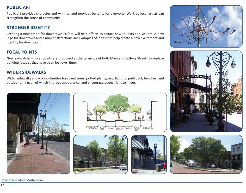
12
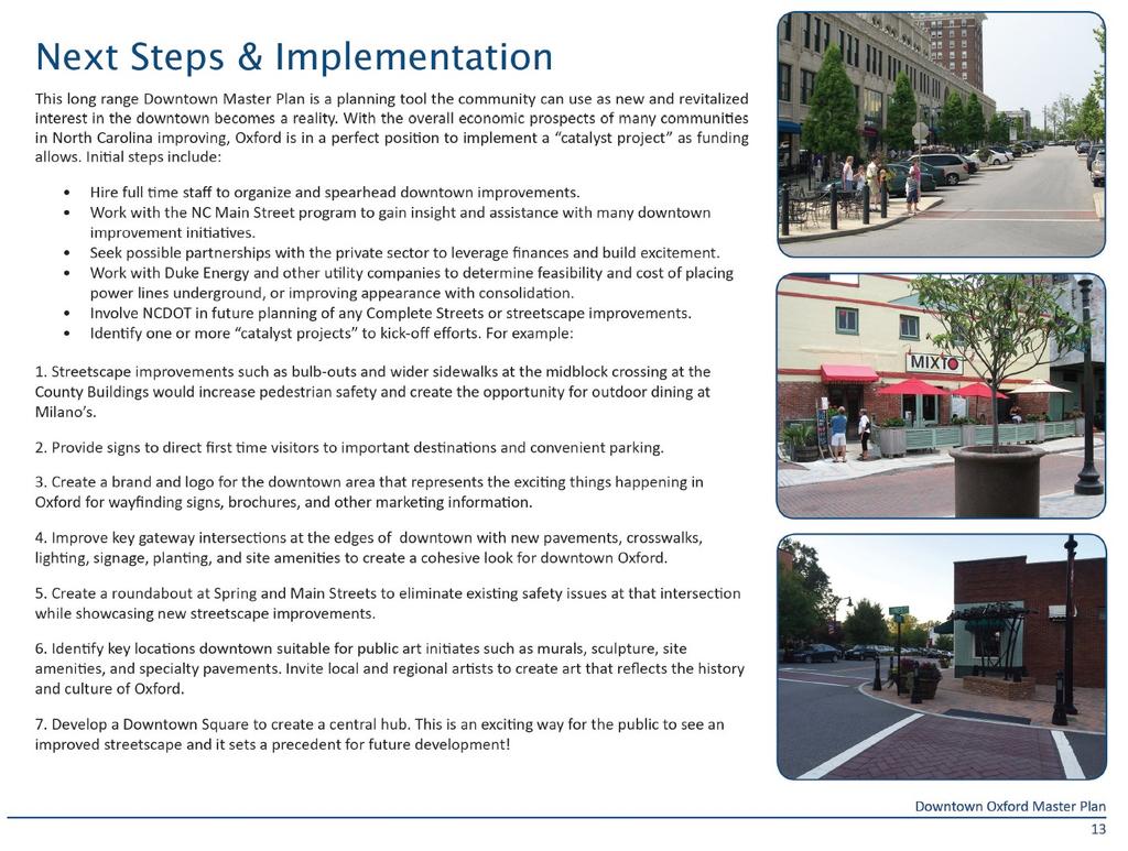
13
14
15
16
17 Phasing and Cost Estimate of Downtown Oxford Master Plan Prepared By:
18 Phasing and Cost Estimate of Downtown Oxford Master Plan Purpose of the Study The primary objective of this study is to identify priority projects and associated budgets for the City s use in planning and pursuit of funding sources. With the Downtown Oxford Master Plan (dated March 2016) as a guide, the consultant team developed a list of projects that would have the most impact toward improving the function, safety, and aesthetics of Downtown Oxford. Prioritization of projects will be further refined with stakeholder input at the June 20th public involvement session and based upon the findings of this study. The prioritizations reflect those improvements that would have the biggest, immediate impacts to the quality of the downtown environment. This study should be viewed as the initial phase of a larger, more detailed Master Plan for Downtown Oxford. Using the data gathered from utility coordination and downtown improvement investigation, this report aims to capture the goals and overall vision for the future of Downtown Oxford. Project Phasing Kimley-Horn processed the existing conditions of the Downtown Oxford Master Plan area to help formulate a figure (See Figure 1) of potential phasing of projects. Estimates of cost to implement these improvements were developed using recent data from similar projects in the market and contingency funds. It is important for the community to understand that the concepts shown in the plan are subject to change based on many factors, including funding, market conditions, and land availability. These estimates are very broad in scope and developed in the absence of detailed surveys or engineering plans but intended to serve as a budget development tool and for funding discussions. Budget Estimates Budget estimates for the priority project list were developed to establish a highlevel order of magnitude cost for implementing selected projects. A summary of costs is provided within this document and represents total estimated values for construction using knowledge derived from a combination of recent market data for similar work and NCDOT pricing guidelines for public projects. A detailed backup for each project was developed with estimates for the major line items of work typically associated with each project. The summary of estimates within this document represent consolidated values derived from those detailed estimates. The primary component of the budget estimates includes the following: Estimate of total construction cost per project (includes basic streetscape amenities such as benches, trach receptacles, tree grates, bike racks Breakdown of estimates for each project into costs for basic construction and the burial of overhead utilities A 20% contingency applied to construction costs Soft costs typically associated with design, engineering, and site investigations such as surveys and geotechnical reports A lump sum line item for a comprehensive wayfinding package also is included as well as an allowance for a focal point within the Main Street and Hillsboro St area as mentioned in more detail in the Downtown Master Plan. The wayfinding signage was recommended to be expanded outside of the Master Plan Downtown limits near I-85 gateways and other gateway approaches to help guide locals and visitors to points of interest within and around the downtown area. New signing graphics and logo for downtown marketing purposes would be part of this allowance as well. It should be noted that these estimates are not based upon design plans, field surveys, or engineering calculations. Instead, they are intended to serve only as a planning tool for future efforts to allocate or seek funding. Detailed site surveys, utility locating services, geotechnical services, and engineering plans will be required to develop more accurate estimates of cost once the City moves forward with section or sections of this plan. At that time, the costs can continue to be refined. Water-sewer infrastructure improvements will need to be coordinated closely with these streetscape projects. Cost for total replacement of water-sewer was not included in these estimates since these water-sewer infrastructure improvements are being funded through grants and loans. The cost summary indicates a potential budget of approximately $24.5 million to accomplish all the identified projects in today s market. Roughly $5.3 million of that total, was allocated to relocate utilities underground if that option was chosen. Inflation was not included and would need to be reviewed by the City in the future. 15

19 Phasing and Cost Estimate of Downtown Oxford Master Plan Figure 1 16
20 Phasing and Cost Estimate of Downtown Oxford Master Plan Overhead Utilities in the Downtown Area One improvement that is being proposed in the Downtown Oxford Master Plan is to reduce the visual clutter created by the many overhead utilities and wooded poles located in and around the sidewalks, buildings, and downtown area streets. In doing so, the recommendation is to bury overhead utilities wherever streetscape work is implemented to create a safer and more visually pleasing downtown. Existing Utilities Downtown As part of this study, the Consultant compiled existing mapping of overhead and underground utility facilities in the study area and walked sections of Downtown to evaluate the existing utility infrastructure. In addition, as part of the cost estimating of the Master Plan, costs for undergrounding all utilities were estimated for each section of the Master Plan and included in a matrix. Some of the main utilities that exist within the corridor include power, fiber, telephone, gas, water, and sewer. Challenges with Relocating and/or Undergrounding Overhead Utilities The Consultant noted some of the challenges with undergrounding utilities within streets such as Main Street, Williamsboro Street, Bank Street, and College Street. Some of the challenges with undergrounding overhead utilities include the following: Existing overhead building awnings will force the utility duct bank to be constructed in the roadway or parking area instead of the preferred sidewalk due to the heavy equipment used with this type of construction and the vertical clearance needed by this equipment Individual overhead services feed to businesses and residential properties along the corridor. They will need to be converted to underground. These conversions can be expensive depending on the age of the building and service. Bringing these services up to current code also is a challenge. Coordination with the City building inspections department will be needed during design and construction. If overhead service is to remain but is being upgraded, horizontal clearances with existing structures/buildings will need to be reviewed by Duke Energy to ensure current code is being met (i.e. Banks Street) Large underground transformer vaults will be needed along the corridor if undergrounding utilities. These vaults are large and expensive. Ample room is needed for their installation. Sometimes existing basements, underground storage tanks, coal chutes, skylight window wells, and/or limited right-of-way can create issues when finding areas to locate these utility vaults. Longer construction time is required when undergrounding utilities within a downtown area. This extra time will need to be added to the total construction time and will have to be done concurrently with the Downtown improvements. All of this can be added impact to businesses if not coordinated appropriately. Constant utility coordination will be needed during design and construction when undergrounding utilities. This will need to be accounted for in the design and construction cost of the improvements. City should also ensure that before any streetscape improvements are made the City updates and/or creates ordinances on the following items: Window Displays, Outdoor Seating, Loading Zones and Handicap Parking, Business Signage Corridor Options and Graphics The Consultant created graphics depicting what options the City has when improving the utilities in downtown. The options include the followings: 1) Underground All Utilities This option consists of burying all overhead utilities in a duct bank (mostly to one side of the street) with secondary conduit runs on both sides of the street. This would include service conversions, underground vaults, manholes, and removal of poles. With Option 1, we would recommend the following section areas: I1, H2, I2, B1, W1, I3, M1, CS1, G4, C1, OUMC1, LJ1, and RBT1 2) Consolidate Overhead Utilities to One Side of the Street This option includes placing all overhead lines to one side of street on new taller poles and burying/converting as many services as possible and overhead crossings of the street. This option would clean up but not eliminate the overhead utilities in the area. The cost typically runs half to two-thirds of the cost of Option 1; however, there would still be a significant amount of trenching and impacts to businesses to implement this option. With Option 2 we would recommend the following section areas: G1, H1, W2, G2, W3, S1, S2, G3, EM1, S3, GS1 17

21 Phasing and Cost Estimate of Downtown Oxford Master Plan 3) Leave Utilities As-Is This option consists of retaining the overhead utilities. With this option, only slight adjustments along the corridor will be required with the streetscape improvements, such as adjusting manholes, guy wires, and meter boxes. Simple adjustments to existing utilities typically cost around 10% of the total construction cost of the streetscape project. We would recommend Option 3 in the outer areas of the downtown where utilities are less cluttered or if the funding becomes limited. The following figures illustrate Options 1, 2, and 3 overlaid on a photo of the corridor. The following streets were depicted graphically: Main Street, Hillsboro Street, Bank Street, and College Street. Hillsboro Street Existing Banks Street Existing Hillsboro Street Option 1 Underground All Utilities e Banks Street Option 1 Underground All Utilities Hillsboro Street Option 2 Consolidate Utilities to One Side of the Street 18


22 Phasing and Cost Estimate of Downtown Oxford Master Plan College Street Existing Main Street Existing College Street Option 1 Underground All Utilities Main Street Option 1 Underground All Utilities College Street Option 2 Consolidate Utilities to One Side of the Street Main Street Option 2 Consolidate Utilities to One Side of the Street 19
23 Phasing and Cost Estimate of Downtown Oxford Master Plan Downtown Oxford Streetscape Master Plan July 11, 2017 ID Priority ESTIM. COST W/ OPTION 1 ESTIM. COST W/ OPTION 2 ESTIM. COST W/ OPTION 3 OPTION 2 REC. SIDE Master Plan Page Reference G1 2 $539, $511, $473, South 5, 8 G2 2 $493, $472, $444, South 5, 8 G3 1 $528, $507, $479, South 5, 8 G4 2 $459, $438, $410, East 5, 8 I1 2 $527, $506, $478, South 5, 8 I2 1 $861, $832, $793, South 4, 5, 8, 9 LOCATION G1 - Gateway at Hillsboro St, McClanahan St, and Lewis St G2 - Gateway at Williamsboro St, Lanier St, and Belle St G3 - Gateway at Martin Luther King Ave and W. Spring St G4 - Gateway at McClanahan St and College St I1 - Hillsboro St and MLK Ave, Broad St Intersection I2 - Hillsboro St and College St, Main St Intersections I2 1 $300, $300, $300, N/A 4, 5, 8, 9, 12 I2-Focal Point I3 2 $470, $452, $428, South 5, 8 RBT1 1 $761, $698, $615, South 5, 8, 9 H1 2 $1,695, $1,515, $1,280, South 5, 8 H2 2 $1,083, $983, $851, South 4, 5, 8 W1 1 $718, $660, $583, South 4, 5, 8, 9 W2 2 $592, $540, $472, South 5, 8 W3 3 $750, $678, $584, South 5, 8 I3 - Hillsboro St and Gilliam St, New College St Intersection RBT1 - Roundabout at Main St and Spring St H1 - Hillsboro St, McClanahan St to Broad St H2 - Hillsboro St, Broad St to College St W1 - Williamsboro St, Main St to Gilliam St W2 - Williamsboro St, Gilliam St to Lanier St W3 - Williamsboro St, Lanier St to Railroad Ave DESCRIPTION OF WORK Sidewalk, New Crosswalks/Curb Ramps, New Signal poles Sidewalk, New Crosswalks/Curb Ramps, New Signal poles Sidewalk, New Crosswalks/Curb Ramps, New Signal poles Sidewalk, New Crosswalks/Curb Ramps, New Signal poles New Curb, New Crosswalks, New Signal poles, New Curb Ramps New Curb, New Crosswalks, New Signal poles, New Curb Ramps Allowance for focal point design and construction New Curb, New Crosswalks, New Signal poles, New Curb Ramps Sidewalk, New Curb Ramps, New Splitter Islands Sidewalk, Bulb-Outs Sidewalk, Bulb-Outs Sidewalk, Bulb-Outs Sidewalk, Bulb-Outs Sidewalk, Bulb-Outs PROJECT PURPOSE Gateway Entrance from the West Gateway Entrance from the East Gateway Entrance from the South Gateway Entrance from the North Full Intersection Improvements Provide Downtown Square for Town Events See Master Plan for placement Full Intersection Improvements Proposed Roundabout Location Traffic Calming Traffic Calming Provide Courthouse Plaza for Town Events Traffic Calming Traffic Calming 20
24 Phasing and Cost Estimate of Downtown Oxford Master Plan ID Priority ESTIM. COST W/ OPTION 1 ESTIM. COST W/ OPTION 2 ESTIM. COST W/ OPTION 3 OPTION 2 REC. SIDE Master Plan Page Reference EM1 3 $1,886, $1,736, $1,598, South 5, 8 LJ1 3 $511, $474, $439, South 5, 8 *OUMC1 3 $260, N/A $217, N/A 5, 8 S1 2 $1,496, $1,353, $1,220, South 5, 8 S2 2 $1,646, $1,466, $1,231, S3 3 $775, $741, $709, East(S) & West(N) East(N) & West(S) CS1 1 $1,147, $1,054, $933, East 4, 5, 8 *B1 1 $376, N/A $241, N/A 4, 5, 8, 9 M1 1 $1,061, $953, $812, West 4, 5, 8 GS1 2 $1,091, $983, $842, East 5, 8 *C1 2 $644, N/A $519, N/A 4, 5, 8, 9 1 $300, $300, $300, N/A 5, 8, 11 5, 8 5, 8 LOCATION EM1 - E. McClanahan St, College St to Lanier St LJ1 - Little John St, Main St to Gilliam St OUMC1 - Oxford United Methodist Church S1 - W. Spring St and E. Spring St S2 - Orange St, Broad St, and MLK Ave S3 - Lanier St and Belle St CS1 - College St, McClanahan St to Hillsboro St B1 - Bank St near Hillsboro St M1 - Main St, Williamsboro St to Spring St GS1 - Gilliam St, Williamsboro St to Spring St C1 - Between Little John St and Williamsboro St Wayfinding Signage Allowance 1 $500, $500, $500, N/A 5, 8 DMS Signage $21,469, $19,932, $17,751, Subtotal Construction (Per Utility Option) DESCRIPTION OF WORK Sidewalk, New Signal, New Curb Ramps, Bulb-Outs Sidewalk Remove Parking, Landscape, Sidewalk Sidewalk Sidewalk Sidewalk Sidewalk, Bulb-Outs Remove Parking, New Curb, Landscape, Sidewalk Sidewalk, Bulb-Outs Sidewalk Remove Parking, New Curb, Landscape, Sidewalk, Develop new signing graphics and logo for downtown marketing and branding purposes 4 DMS signs strategically located on Gateway Approaches PROJECT PURPOSE Full Intersection Improvements, Traffic Calming Sidewalk North side only 10' Sidewalk Sidewalk on both sides Improve Pedestrian Connectivity Improve Pedestrian Connectivity Traffic Calming Provide Festival Space for Town Events Traffic Calming Connect Housing to Shopping Create Greenspace for People Provide signing for downtown navigation Provide messages for downtown activity $3,220, $2,989, $2,662, % Soft Costs (Design/Survey/Site Testing) $24,689, $22,921, $20,413, GRAND TOTAL (Per Utility Option) * These projects include the removal of parking per the Master Plan Phase 1. Recommend further review for future parking removal to ensure new improvements compensate for lost parking. 21
Option W: N. Washington Street Project
 Option W: N. Washington Street Project Location: one block of North Washington Street, between West Broad Street and Park Avenue Description: upgrades to existing lighting new brick sidewalk to replace
Tonight is for you. Learn everything you can. Share all your ideas.
 Strathcona Neighbourhood Renewal Draft Concept Design Tonight is for you. Learn everything you can. Share all your ideas. What is Neighbourhood Renewal? Creating a design with you for your neighbourhood.
Knox Street Complete Streets Project
 Knox Street Complete Streets Project Meeting Purpose Get community feedback on two conceptual street design options Meeting Agenda Presentation (20 minutes) Project background and schedule Summary of preferences
City of Darlington Beautification Report
 City of Darlington Beautification Report Approved by the City of Darlington Beautification Board February 2016 The New Downtown Darlington has seen many changes during the past decade with the rehabilitation
A CHANGING CITY. of Edmonton, it is essential that it reflects the long-term vision of the City.
 A CHANGING CITY By the year 2040, Edmonton will be home to more than 1 million people. To accommodate growth and support a healthy and compact city, we need a new approach to development/redevelopment
Henderson Ave. Complete Streets Project
 Henderson Ave. Complete Streets Project Meeting Purpose To finalize conceptual components of project prior to proceeding with preliminary engineering www.dallascompletestreets.wordpress.com MeetingAgenda
Executive Summary Route 30 Corridor Master Plan
 Route Corridor Master Plan Project Overview The Route Corridor Master Plan is a coordinated multimodal transportation and land use plan for the entire stretch of Route through East Whiteland Township,
MARTIN LUTHER KING JR. WAY
 OCTOBER 2011 40 Vision and Goals The Martin Luther King, Jr. Way Illustrative Master Plan that follows has been developed through a process of community involvement. It expresses a long term vision for
MAG Town of Cave Creek Bike Study Task 6 Executive Summary and Regional Significance Report
 Page 1 MAG Town of Cave Creek Bike Study Task 6 Executive Summary and Regional Significance Report August 1, 2012 MAG Project #481 Page 2 Task 6 Executive Summary and Regional Significance Report Introduction
CITY OF PORTSMOUTH PLANNING DEPARTMENT
 CITY OF PORTSMOUTH PLANNING DEPARTMENT MEMORANDUM TO: JOHN P. BOHENKO, CITY MANAGER FROM: JULIET T.H. WALKER, PLANNING DIRECTOR SUBJECT: BICYCLE / PEDESTRIAN PLAN PROGRESS UPDATE DATE: 3/13/2018 Background
CONNECTIVITY PLAN. Adopted December 5, 2017 City of Virginia Beach
 CONNECTIVITY PLAN Adopted December 5, 2017 City of Virginia Beach CONTENTS 1.0 Background & Purpose... 2 2.0 Existing Inventory & Analysis... 3 ViBe District Existing Walking Conditions... 4 3.0 ViBe District
Lincoln Highway Streetscape Plan Concept Plan
 Lincoln Highway Streetscape Plan Concept Plan November 14, 2014 Introduction This report provides a summary of conceptual transportation, land use, and design recommendations in the Lincoln Highway Streetscape
Brooklyn Boulevard (County Road 152) Reconstruction Project Phase I. OPEN HOUSE June 20, 2017
 Reconstruction Project Phase I. OPEN HOUSE June 20, 2017") Brooklyn Boulevard (County Road 152) Reconstruction Project Phase I OPEN HOUSE June 20, 2017 Brooklyn Boulevard (County Road 152) Phase I Project Partners Project Lead Other Project Partners include Brooklyn
Brooklyn Boulevard (County Road 152) Reconstruction Project Phase I OPEN HOUSE June 20, 2017 Brooklyn Boulevard (County Road 152) Phase I Project Partners Project Lead Other Project Partners include Brooklyn
STONY PLAIN ROAD STREETSCAPE
 Jasper Place Revitalization Strategy: Vision The people involved in the Jasper Place Revitalization Strategy envision: Goal 1: Feeling safe in our community Create a community where feeling safe is common--where
Make Lincoln Highway an economically vibrant corridor that is safe, efficient, and beautiful for local residents and visitors.
 Lincoln Highway Streetscape Plan Stakeholder Workshop #2 Handout Contents Introduction and Project Vision Planning Principles Specific Recommendations including a Proposed Typical Roadway Section Renderings
4 GENERIC COST ESTIMATING TOOL
 4 GENERIC COST ESTIMATING TOOL Table 4-1 presents a generic cost estimating tools that can serve as a conceptual planning tool for local jurisdictions to estimate the costs of pedestrian improvements.
Blackfalds Downtown. Architectural Guidelines: Streetscape
 Blackfalds Downtown Architectural Guidelines: Streetscape Streetscape INTRODUCTION A variety of street furniture has been chosen for locations within the Town of Blackfalds Downtown and highway commercial
Fulton Market Streetscape
 Fulton Market Streetscape Ogden Avenue to Halsted Street Public Meeting Recommended Improvements December 10th, 2014 Meeting Purpose and Goals Present Existing Conditions Community Input and Charrette
Chapter 4: Funding and Implementation
 Chapter 4: Funding and Implementation 83 84 Cost Estimating Cost estimating is an iterative process. When a project is in the conceptual stage, preliminary cost estimates are also provided conceptually,
Memo. Ocean Avenue Corridor Design Project Public Workshop #2 Summary
 Ocean Avenue Corridor Design Project Public Workshop #2 Summary The second public workshop for the Ocean Avenue Corridor Design Project was held on Wednesday, May 14, 2014 from, 6 to 8 pm at Lick Wilmerding
FOCUS AREA 1 - Alberta Avenue Pocket Park 3 (121 Ave and 92 St)
") FOCUS AREA 1 - Alberta Avenue Pocket Park 3 (121 Ave and 92 St) New benches Plant evergreen trees Widen existing sidewalk from 1.5m to 1.8m Marked crosswalk 1.8m wide sidewalk Add pedestrian oriented lights
FOCUS AREA 1 - Alberta Avenue Pocket Park 3 (121 Ave and 92 St) New benches Plant evergreen trees Widen existing sidewalk from 1.5m to 1.8m Marked crosswalk 1.8m wide sidewalk Add pedestrian oriented lights
14 TH STREET TRANSPORTATION & STREETSCAPE DESIGN STUDY PLAN B PLAN B TRANSPORTATION & STREETSCAPE RECOMMENDATIONS
 14 TH STREET TRANSPORTATION & STREETSCAPE DESIGN STUDY PLAN B PLAN B TRANSPORTATION & STREETSCAPE RECOMMENDATIONS 141 Symbols Recommendations - Southern End of 14th Street Study Area Streetscape Each icon
Miami Health District
 Miami Health District Streetscapes, Gateways, and Signage Basis of Design Report Study Miami Partnership Meeting July 21, 2008 Gannett Fleming EDAW The Corradino Group Sponsored by the Miami Partnership:
CLOSED. Highlights of the Final Concept Design:
 The final Concept Design is the result of many months of listening, learning, creating, balancing, and understanding different needs and viewpoints, as well as incorporating technical requirements and
Ocean Park Boulevard Green Street Project Community Workshop
 Ocean Park Boulevard Green Street Project Community Workshop 2.2.10 Project Objectives Community Priority: reclaim OPB for public open space. Build upon LUCE principles; neighborhood enhancement, connectivity,
integrated action plan
 public presentation. june 24, 2009. city of portsmouth, nh islington corridor integrated action plan richardson & associates, landscape architects evan haynes, public arts consultant Islington Street Corridor
S T A T I O N A R E A P L A N
 The Circulation and Access Plan describes vehicle, pedestrian, and transit improvements recommended within the Concept Plan. In order to create and sustain a vibrant business district that provides pedestrian-friendly
DRAFT. A fifth objective, other considerations, has been added to capture considerations not captured by the four primary objectives.
 TECHNICAL MEMORANDUM Albany - Washington Avenue Traffic Calming Evaluation Matrix of Conceptual Alternatives Date: May 17, 2017 Project #: 17356 To: Aleida Andrino-Chavez From: Laurence Lewis, Sara Muse,
Pennsylvania Avenue (CR 484) Design Alternatives Study
 Design Alternatives Study") MEMORANDUM Pennsylvania Avenue (CR 484) Design Alternatives Study Prepared for: APRIL 2016 Prepared By TABLE OF CONTENTS Project Background... 2 Previous Concept... 2 Existing Conditions... 4 New Alternatives...
MEMORANDUM Pennsylvania Avenue (CR 484) Design Alternatives Study Prepared for: APRIL 2016 Prepared By TABLE OF CONTENTS Project Background... 2 Previous Concept... 2 Existing Conditions... 4 New Alternatives...
Preliminary Design of Wayzata Boulevard Improvements(CSAH 112)
") Project Area Map 6 COUNTY 112 COUNTY Preliminary Design of Wayzata Boulevard Improvements(CSAH 112) Public Open House Open House To Do List: Sign in Visit with Hennepin County staff and design team Learn
Project Area Map 6 COUNTY 112 COUNTY Preliminary Design of Wayzata Boulevard Improvements(CSAH 112) Public Open House Open House To Do List: Sign in Visit with Hennepin County staff and design team Learn
Commerce Street Complete Street Project from Good Latimer Expressway to Exposition Avenue
 Commerce Street Complete Street Project from Good Latimer Expressway to Exposition Avenue T A N Y A B R O O K S A S S I S T A N T D I R E C T O R M O B I L I T Y P L A N N I N G M O B I L I T Y A N D S
Southview Blvd & 3 rd Avenue Improvement Project. Public Open House December 4, to 7pm
 Southview Blvd & 3 rd Avenue Improvement Project Public Open House December 4, 2014 5 to 7pm Southview Blvd & 3 rd Avenue Public Information Meeting Agenda Presentation 5:30 to 6:15 pm Purpose of Project
PUBLIC REALM MASTER PLAN
 WESTSHORE BUSINESS DISTRICT PUBLIC REALM MASTER PLAN MASTER PLAN COMMITTEE MEETING MARCH 20, 2013 WESTSHORE BUSINESS DISTRCT PUBLIC REALM MASTER PLAN MACRO-SCALE CONCEPT: A PUBLIC REALM FRAMEWORK DEFINED
Safe Streets. City of Lake Forest Park. March 21, 2017
 Safe Streets City of Lake Forest Park March 21, 2017 1 01 WELCOME 2 Agenda WELCOME WHAT IS THIS PROJECT? CONTEXT DRAFT CITYWIDE PROJECTS EXERCISE INTRODUCTION 3 02 WHAT IS THIS PROJECT? 4 WHAT IS THIS
DRAFT. Table of Contents. Background
 Douglas County Table of Contents Existing Infrastructure 86 Funding 89 Policy and Program Recommendations 90 Infrastructure Recommendations 92 Conclusion 95 Background Home to 4,500 residents and Baker
Broad Street Bicycle Boulevard Design Guidelines
 Broad Street Bicycle Boulevard Design Guidelines Building from the strategies introduced in the 2013 Bicycle Transportation Plan and community input received thus far, City Transportation Staff have identified
Paoli Road Improvement Feasibility Study
 Paoli Road Improvement Feasibility Study & Public Participation Project March 24, 2015 Prepared for: Tredyffrin Township Prepared by: McMahon Associates, Inc. with Town Planning Partnership, LLC Glackin
Observations and Ideas: Toomer s Corner Streetscape Improvements
 Observations and Ideas: Toomer s Corner Streetscape Improvements AUBURN DOWNTOWN MASTER PLAN planning downtown s future August 26, 2013 Observations: Vertical Clutter at Corners 6 3 7 5 9 2 8 4 1 Excess
Complete Streets. Designing Streets for Everyone. Sarnia
 Complete Streets Designing Streets for Everyone Sarnia Complete Streets ~ Sarnia ~ 2018 Introduction Our City is made up of a network of streets that we use to go for a walk, cycle to work, drive to the
MEMO. Executive Summary
 MEMO TO: Steve Wheeler FROM: Scott Vanden Bos, Elaine Howard RE: Hood River Heights Urban Renewal Area Public Input Live and Online DATE: November 30, 2017 Executive Summary Following the conclusion of
WELCOME. Purpose of the Open House. Update you on the project. Present a draft recommended plan. Receive your input
 WELCOME Purpose of the Open House The Town of Smiths Falls has initiated the Beckwith Street Redevelopment Plan that includes the preparation of a streetscape functional design for the renewal of Beckwith
Community Meeting February 27, 2007 Dorchester Avenue Transportation & Streetscape Improvements Action Plan February 27, 2007
 Community Meeting Tonight s Agenda 6:00 Introductions South Boston/Dot Ave Improvement Study Background 6:15 Consultant Introductions Review of Scope and Schedule Review of Proposed Corridor Wide Guidelines
Oakland Pedestrian Master Plan Oakland Pedestrian Plan Draft Recommendations Chapter Outline
 EISEN LETUNIC T R A N S P O R T A T I O N, ENVIRO N M E N TA L A N D URBAN PLANNIN G MEMORANDUM To Oakland Pedestrian Plan Technical Advisory Committee & Pedestrian Advisory Group From Victoria Eisen Date
AGENDA ITEM G-2 Public Works
 AGENDA ITEM G-2 Public Works STAFF REPORT City Council Meeting Date: 12/6/2016 Staff Report Number: 16-214-CC Regular Business: Approve the Oak Grove University Crane Bike Improvement Concept Plan, authorize
University of Victoria Campus Cycling Plan Terms of Reference. 1.0 Project Description
 University of Victoria Campus Cycling Plan Terms of Reference 1.0 Project Description The Campus Cycling Plan, a first for the University, will provide a comprehensive and coordinated approach to support
PEDESTRIAN CIRCULATION & STREETSCAPE DESIGN
 CHAPTER 4 Chapter 4 Pedestrian Circulation & Trails PEDESTRIAN CIRCULATION & STREETSCAPE DESIGN In recent years, the City has constructed new sidewalks and enhanced existing ones in the downtown with brick
Bridgewater Complete Streets Prioritization Plan and Pedestrian Safety Assessment
 Bridgewater Complete Streets Prioritization Plan and Pedestrian Safety Assessment Presented by Luciano Rabito Manager of Complete Streets Presented to Bridgewater, MA Wednesday, April 26, 2017 6:30 P.M.
STREETSCAPE CONCEPT PLAN
 03 STREETSCAPE CONCEPT PLAN Zone 1 This zone includes the gateway into both the downtown and the Village at Harlem. The gateway features are shown closer to the Harlem intersection to make them more prominent.
Bicycle and Pedestrian Advisory Committee (BPAC) November 21, 2013
 November 21, 2013") Bicycle and Pedestrian Advisory Committee (BPAC) November 21, 2013 OVERALL LAND USE CONCEPT Overall Broadway Valdez District: 95.5 acres (35.1 acres right-of ways + 60.4 acres developable land) Plan Subareas:
Bicycle and Pedestrian Advisory Committee (BPAC) November 21, 2013 OVERALL LAND USE CONCEPT Overall Broadway Valdez District: 95.5 acres (35.1 acres right-of ways + 60.4 acres developable land) Plan Subareas:
2014/2015 BIKE ROUTE PLAN 83 AVENUE PROTECTED BIKE LANE
 About the Project 2014/2015 BIKE ROUTE PLAN The City of Edmonton is planning a major bike route on the south side of Edmonton. This bike route is one part of a plan to provide citizens with transportation
Town of Ashland. Downtown Planning Initiative 2 nd Community Workshop. March 29, Presented by:
 Town of Ashland Downtown Planning Initiative 2 nd Community Workshop Presented by: March 29, 2018 Agenda Tonight Review project & goals Recap 1st workshop (September 18, 2017) Present design alternatives
Functional, Preliminary Design and Detailed Design
 Functional, Preliminary Design and Detailed Design Main Street (Echo Drive to the Rideau River), Lees Avenue (Main Street to Chestnut Street), and Rideau River Drive (Main Street to 130m south of Main
5. Automobile Circulation, Wayfinding and Signage
 5. Automobile Circulation, Wayfinding and Signage Policy: The City Center should have a balanced, safe, and interconnected circulation system that provides expanded travel opportunities for transit, pedestrian,
Good Neighbor Plan Initiative Update. Transportation & Trinity River Project Committee 9 September 2013 Dallas Love Field Phase One Final Report
 Good Neighbor Plan Initiative Update Transportation & Trinity River Project Committee 9 September 213 Dallas Love Field Phase One Final Report PURPOSE As briefed to the Transportation and Environmental
Citizen Advisory Group Meeting #8 May 5, Welcome. Today s meeting will focus on: Land Use & Transportation CHARLOTTEPLANNING.
 Citizen Advisory Group Meeting #8 May 5, 2010 Welcome. Today s meeting will focus on: Land Use & Transportation CHARLOTTEPLANNING.ORG Meeting Agenda Handouts: o Meeting Agenda o Summary of East Seventh
Community Task Force November 15, 2017
 Community Task Force November 15, 2017 Welcome and Introductions Project Partners Regional Transportation District (RTD) Colorado Department of Transportation (CDOT) Denver Regional Council of Governments
El Centro Mobility Hub
 The El Centro drive shed comprises a major portion of the El Centro downtown area, which is well served by bus routes. The proposals intend to promote use of public transit through improvements and enhancements
CLOSED. The draft concept design has been broken down into 5 categories for the purpose of this survey:
 Old Strathcona s neighbourhood renewal process is now at the draft concept design phase. Over the last several months, the city has been gathering local knowledge and resident input that has been used
Governance and Priorities Committee Report For the July 2, 2015 Meeting
 CITY OF VICTORIA For the July 2, 2015 Meeting To: Governance and Priorities Committee Date: From: Subject: Brad Dellebuur, A/Assistant Director, Transportation and Parking Services Executive Summary The
About the study. North Milwaukee Ave. Key goals of this study are to: Achieve Vision Zero* by. Harmonize the space and improve walkability
 About the study Key goals of this study are to: North Milwaukee Avenue is a local and regional street for multiple modes of transportation. It is officially zoned and functions as a pedestrian street southeast
Enhancing Downtown
 Enhancing Downtown 2014-2015 Process Masterplan reviewed TIF scope, fund availability, and timing Conceptual cost estimate stage things may change with full engineering Sequencing Coordination with businesses
Elm Street Business District: Streetscape and Signage Plan
 Winnetka Preliminary Streetscape & Signage Village Council Presentation 1 Elm Street Business District: Streetscape and Signage Plan VILLAGE OF WINNETKA DOWNTOWN MASTER PLAN VILLAGE COUNCIL PRESENTATION
HARRISON STREET/OAKLAND AVENUE COMMUNITY TRANSPORTATION PLAN
 HARRISON STREET/OAKLAND AVENUE Community Workshop #4: Draft Plan Review December 3, 2009 D E S I G N, C O M M U N I T Y & E N V I R O N M E N T INTRODUCTIONS Key Project Staff: Alisa Shen, Project Manager,
CITY MANUALS AND STANDARDS REVIEW
 GEORGETOWN SIDEWALK MASTER PLAN CITY MANUALS AND STANDARDS REVIEW RESOURCES AND STANDARDS As part of the Master Plan process, a review and evaluation of current City documents and policies relevant to
WHITE STREET/ ENGLISH PLAZA STREETSCAPE IMPROVEMENT PROJECT
 WHITE STREET/ ENGLISH PLAZA STREETSCAPE IMPROVEMENT PROJECT 1 Project Goals 1 Improved Safety: Lighting, Multi-Modal Circulation, Emergency Access, Tripping Hazards; Stormwater 4 Environmental Performance:
MERRIMACK TOWN CENTER PEDESTRIAN AND TRAIL MASTER PLAN
 MERRIMACK TOWN CENTER PEDESTRIAN AND TRAIL MASTER PLAN NOVEMBER 12, 2009 PREPARED BY: NASHUA REGIONAL PLANNING COMMISSION Cover art designed at www.wordle.net/create. This design is based upon the words
THE ALAMEDA CONCEPT DESIGN COMMUNITY MEETING 3. A Plan for The Beautiful Way JANUARY 28, 2010
 CONCEPT DESIGN COMMUNITY MEETING 3 JANUARY 28, 2010 AGENDA INTRODUCTION COMMUNITY INPUT ROADWAY STUDIES STREETSCAPE DESIGN STATIONS DISCUSSION SUMMARY AND DISCUSSION NEXT STEPS CLOSE INTRODUCTION SCHEDULE
City of Birmingham Draft Multi-modal Transportation Plan
 City of Birmingham Draft Multi-modal Transportation Plan City Commission Public Hearing Monday, November 25, 2013 7:30 pm Norman Cox, PLA, ASLA The Greenway Collaborative, Inc. Ann Arbor, Michigan The
PEDESTRIAN ACTION PLAN
 ATTACHMENT 2 CITY OF SANTA MONICA PEDESTRIAN ACTION PLAN CITY OF SANTA MONICA PEDESTRIAN ACTION PLAN This page intentionally left blank EXECUTIVE SUMMARY CHAPTER 1 EXECUTIVE SUMMARY Setting the Stage
Safe Routes to School Action Plan Aberdeen, Idaho
 Background Aberdeen, Idaho is a largely agricultural community of nearly 2,000 people and is located in the southeast portion of the state on the western edge of American Falls Reservoir. The community
UDC Street Cross Sections
 UDC Street Cross Sections Local Street - Downtown Local Street Mountable Curb Local Street Vertical Curb Alley Major Arterial Minor Arterial Residential Lane Residential Collector Residential Collector
Proposed. City of Grand Junction Complete Streets Policy. Exhibit 10
 Proposed City of Grand Junction Complete Streets Policy Exhibit 10 1 City of Grand Junction Complete Streets Policy Vision: The Complete Streets Vision is to develop a safe, efficient, and reliable travel
Sacramento Grid 2.0. The Downtown Transportation Study
 Sacramento Grid 2.0 The Downtown Transportation Study April 20, 2016 The Grid 4.25 square miles Street grid defined at birth of City Lettered and numbered streets spaced every 400 ft East-west alleys halfway
TRAVEL PLAN: CENTRAL EUROPEAN UNIVERSITY CAMPUS REDEVELOPMENT PROJECT TRAVEL PLAN. Central European University Campus Redevelopment Project.
 TRAVEL PLAN Central European University Campus Redevelopment Project Page 1 Table of Contents Introduction... 3 Background... 7 Building Users... 7 Transportation in Community Consultation... 7 Summary
TRAFFIC CALMING TOOLBOX. For the residents of the City of Decatur, Georgia
 TRAFFIC CALMING TOOLBOX For the residents of the City of Decatur, Georgia 2 City of Decatur Traffic Calming Toolbox Public Works Department 2635 Talley Street Decatur, GA 30030 404.377.5571 3 Welcome to
GRTC Bus Rapid Transit: Semi-Final Design Phase Public Meetings: October 26 & 27, 2015
 GRTC Bus Rapid Transit: Semi-Final Design Phase Public Meetings: October 26 & 27, 2015 Welcome! Meeting Agenda Project update presentation Up to 15 minutes for Pulse Q&A about project design. (Please reserve
PROPOSED BICYCLE AND PEDESTRIAN FACILITY Vicinity of Route 123/I-495 Interchange Tysons, Fairfax County, Virginia
 PROPOSED BICYCLE AND PEDESTRIAN FACILITY Vicinity of Route 123/I-495 Interchange Tysons, Fairfax County, Virginia PRELIMINARY ENGINEERING REPORT Prepared for: Prepared by: July 2017 Table of Contents 1
Welcome. Thank you for your interest in the Lewis & Clark Viaduct Concept Study
 Welcome Thank you for your interest in the Lewis & Clark Viaduct Concept Study Please use the arrows in the upper left hand corner to navigate through the presentation. Use the envelope icon to ask a question
Ocean Park Boulevard Streetscape Improvement Project Alternatives & Trade Offs
 City Council Study Session January 27, 2009 Ocean Park Boulevard Streetscape Improvement Project Alternatives & Trade Offs Scope of Work Purpose of Tonight s Meeting Review work to date and direct staff
DEPARTMENT OF ENVIRONMENTAL SERVICES. North Harrison Street (Lee Highway to Little Falls Road) Comparative Analysis. Prepared for:
 Comparative Analysis. Prepared for:") DEPARTMENT OF ENVIRONMENTAL SERVICES North Harrison Street (Lee Highway to Little Falls Road) Comparative Analysis Prepared for: Arlington County Department of Environmental Services 2100 Clarendon Boulevard,
DEPARTMENT OF ENVIRONMENTAL SERVICES North Harrison Street (Lee Highway to Little Falls Road) Comparative Analysis Prepared for: Arlington County Department of Environmental Services 2100 Clarendon Boulevard,
2014/2015 BIKE ROUTE PLAN 83 AVENUE PROTECTED BIKE LANE
 About the Project The City of Edmonton is planning a major bike route on the southside of Edmonton. The Strathcona Bike Route will connect the communities of Strathcona, Garneau and the University area,
PRINCE GEORGE S PLAZA METRO AREA PEDESTRIAN PLAN
 PRINCE GEORGE S PLAZA METRO AREA PEDESTRIAN PLAN May 28, 2008 Agenda Welcome and introductions Project overview and issue identification Planning context and strengths Design challenges and initial recommendations
Omaha s Complete Streets Policy
 Omaha s Complete Streets Policy (Adopted August 2015) VISION To create great places and enhance our quality of life, the City of Omaha will provide safe, accessible streets for all users. Complete Streets
Building Great Neighbourhoods BELLEVUE AND VIRGINIA PARK
 Building Great Neighbourhoods BELLEVUE AND VIRGINIA PARK This is Meeting 2 Unfortunately, some residents in Bellevue and Virginia Park received the wrong information for this public open house (Meeting
Summary: Mercer County Princeton Avenue & Spruce Street Study January 2009
 Summary: Several recent studies have assessed potential development and redevelopment opportunities in the Mercer Crossing area of Trenton, Ewing, and Lawrence. This Princeton Avenue and Spruce Street
6.4 RECOMMENDED IMPROVEMENTS
 6.4 RECOMMENDED IMPROVEMENTS 6.4.1 Williston Road Recommendations While all alternatives would be an improvement over existing conditions, Alternative 3B is recommended over the others because it provides
Meade Street Bridge Design Alternative Study
 Meade Street Bridge Design Alternative Study Preferred Alternative Presentation Stakeholder Meeting #3 June 23, 2011 Presented by: Dan Biggs, RLA Meeting Agenda Purpose: 1. Review Meeting #2 Feedback 2.
Pine Hills Road Pedestrian/Bicycle Safety Study Board of County Commissioners Work Session
 Pine Hills Road Pedestrian/Bicycle Safety Study Board of County Commissioners Work Session February 20, 2018 Meeting Agenda Study Overview Existing Conditions Access Management Potential Gateway Features
PROJECT OBJECTIVES. Improve vehicle capacity for the intersection. Improve pedestrian and bicycle access
 COMMUNITY MEETING Project Update March 15, 2010 Purcellville, Virginia OVERVIEW Project need / objectives Project recap Design elements Proposed improvements Summary of project benefits / next steps PROJECT
s a n f r a n c i s c o
 s a n f r a n c i s c o BETTER STREETS PLAN Policies and Guidelines for the Pedestrian Realm F I N A L D R A F T R E L E A S E P A C K E T J U L Y 2 0 1 0 i n s i d e : L E T T E R F R O M M A Y O R G
Technical Working Group November 15, 2017
 Technical Working Group November 15, 2017 Welcome and Introductions Project Partners Regional Transportation District (RTD) Colorado Department of Transportation (CDOT) Denver Regional Council of Governments
Agenda. Overview PRINCE GEORGE S PLAZA METRO AREA PEDESTRIAN PLAN
 PRINCE GEORGE S PLAZA METRO AREA PEDESTRIAN PLAN May 28, 2008 Agenda Welcome and introductions Project overview and issue identification Planning context and strengths Design challenges and initial recommendations
Open House Summary INTRODUCTION COMMUNITY COMMENTS
 Open House Summary INTRODUCTION On October 1, 2013, the City of Sonora held a Community Open House to share the draft Vision Sonora Plan with the community and seek input on the components of the draft
FOLSOM-HOWARD STREETSCAPE OVERVIEW
 FOLSOM-HOWARD STREETSCAPE OVERVIEW SoMa residents should have the same kinds of amenities that other neighborhoods have. The Folsom- Howard Streetscape Project will make SoMa more livable by making it
NEWMARKET UPHAM S CORNER
 SOUTH STATION Planning Initiative NEWMARKET UPHAM S CORNER COLUMBIA ROAD (P) FOUR CORNERS/GENEVA Working Advisory Group (WAG) Meeting #5 TALBOT AVENUE MORTON STREET BLUE HILL AVE/CUMMINS HWY (P) RIVER
Building Great Neighbourhoods LANSDOWNE
 Building Great Neighbourhoods LANSDOWNE We are here today to Explain how the City is investing in improving your neighbourhood and how your neighbourhood will be improved to meet current City standards.
CITY OF COCOA BEACH 2025 COMPREHENSIVE PLAN. Section VIII Mobility Element Goals, Objectives, and Policies
 CITY OF COCOA BEACH 2025 COMPREHENSIVE PLAN Section VIII Mobility Element Goals, Objectives, and Policies Adopted August 6, 2015 by Ordinance No. 1591 VIII MOBILITY ELEMENT Table of Contents Page Number
Chapter 3: Multi-Modal Circulation and Streetscapes
 CHAPTER 3: MULTI-MODAL CIRCULATION AND STREETSCAPES Chapter 3: Multi-Modal Circulation and Streetscapes Overview Streetscape improvements have already been completed for Depot Street between Main Avenue
Ocean Park Boulevard Green Street Project Alternatives & Trade Offs
 Planning Commission March 4, 2009 Ocean Park Boulevard Green Street Project Alternatives & Trade Offs Purpose of Tonight s Meeting Review concept plans and options Provide input on alternatives and trade-offs
UNIVERSITY AVENUE CORRIDOR REDESIGN. January 8, 2017 PUBLIC OPEN HOUSE
 January 8, 2017 PUBLIC OPEN HOUSE COLLABORATIVE COMMUNITY-BASED DESIGN IS THE FOUNDATION TO A SUCCESSFUL PROJECT AGENDA FOR TONIGHT 1 INTRODUCTIONS 2 WHY ARE WE HERE PROJECT NEED 3 SCHEDULE & GOALS 4 OPEN