PEDESTRIAN / BICYCLE SAFETY REVIEW
|
|
|
- Christian Lee
- 5 years ago
- Views:
Transcription


1 PEDESTRIAN / BICYCLE SAFETY REVIEW SR 50 / Clearlake Road from Dixon Boulevard to Michigan Avenue Prepared for: Space Coast Transportation Planning Organization 2725 Judge Fran Jamieson Way Bldg. B / Room 05 / MS #82 Melbourne, FL Prepared by: Kittelson & Associates, Inc. 225 E. Robinson Street, Suite 450 Orlando, FL kittelson.com February 206

2 Pedestrian/Bicycle Safety Action Plan Pedestrian/Bicycle Safety Review Report for SR 50/Clearlake Road from Dixon Boulevard to Michigan Avenue Section Number: Mile Post: Brevard County Prepared for: Space Coast Transportation Planning Organization 2725 Judge Fran Jamieson Way, Building B, Room 05 Melbourne, FL Prepared by: Kittelson & Associates, Inc. 225 E Robinson St., Suite 450 Orlando, FL, 3280 February 206
3 Project Title: SR 50/Clearlake Road Pedestrian/Bicycle Safety Review Field Review Dates: September st and 2 nd, 205 (daytime/nighttime reviews and follow up meeting) Participants: Ryan Cunningham Kittelson & Associates, Inc. Team Leader Laura Carter Space Coast Transportation Planning Organization Georganna Gillette Space Coast Transportation Planning Organization Steven Bostel Space Coast Transportation Planning Organization Joan Carter Florida Department of Transportation, District 5 Kevin Marquez Florida Department of Transportation, District 5 Conroy Jacobs Brevard County Devin Swanson Brevard County Ed Wegerif City of Cocoa Officer Bob Wehner Cocoa Police Department Joe Chagnon Space Coast Area Transit Michael Eagle Kittelson & Associates, Inc. Project Characteristics: Field Review Type: Pedestrian, Bicycle, Existing Road Adjacent Land Use: Urban, Commercial, Institutional, Residential Posted Speed Limit: 45 miles per hour (mph) along the length of the study corridor Opposite Flow Separation: Center Two Way Left Turn Lane (TWLTL) Service Function: Urban Minor Arterial Terrain: Flat Climatic Conditions: Sunny, Hot

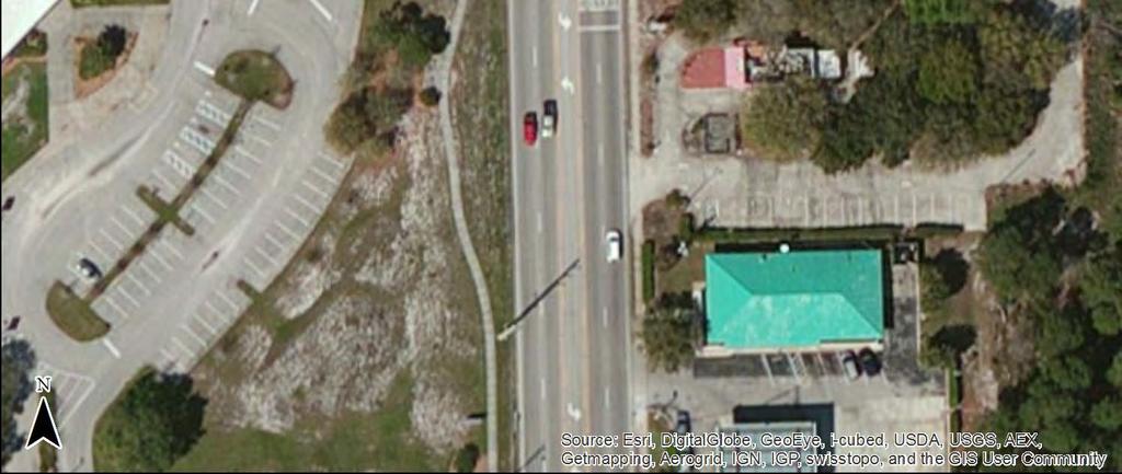
, a.04 mile corridor in central Brevard County was identified as one of these high crash locations.")
4 END PROJECT BEGIN PROJECT Source: Google Maps 205 Figure SR 50/Clearlake Road Study Corridor Background In late 204, the Florida Department of Transportation (FDOT) released its Pedestrian and Bicycle Focused Initiative for 205 and identified Brevard County as a Top 5 High Priority County. The goal of the Pedestrian/Bicycle Safety Action Plan is to generate a list of suggested improvements at high crash locations to address the growing need for improved pedestrian/bicycle safety in Brevard County. SR 50/Clearlake Road from Dixon Boulevard to Michigan Avenue (Figure ), a.04 mile corridor in central Brevard County was identified as one of these high crash locations. In order to suggest improvements along this high crash corridor, the crash history was evaluated and a field review was conducted. This pedestrian/bicycle safety review was commissioned by the Space Coast Transportation Planning Organization (SCTPO) to develop maintenance type, near term, and long term suggestions to improve pedestrian and bicyclist safety within the study limits. The pedestrian/bicycle safety review process involves multi disciplinary representatives from various stakeholders, potentially including representatives from transportation planning, traffic operations, roadway design, safety, and law enforcement. Pedestrian/bicycle safety reviews are conducted to identify potential safety issues and provide improvement suggestions in a team collaborative environment. This safety review is limited in scope and should not be construed as a comprehensive safety study; nor is it a formal Road Safety Audit. It is intended to identify potential operational and safety improvements related to pedestrians and bicyclists to be considered by SCTPO staff and partner agencies (i.e. FDOT District Five (D5), Brevard County, City of Cocoa, SCAT, local law enforcement). Some 2
5 improvements presented in this report may be implemented as maintenance type activities while other suggested safety improvements may be considered for future study. Each suggestion identified in this study is classified into one of three categories: Maintenance issues identified for maintenance may be addressed by public agency staff on a short timeframe and at a relatively low cost. Near Term Improvement (within 3 to 5 years) activities that may be incorporated into an upcoming construction project in the area, including 3R milling and resurfacing projects. Long Term Improvement (5+ years) activities that may be incorporated into upcoming construction projects and may need to be programmed for funding as separate projects. The issues and suggested improvements reflect the consensus of the pedestrian/bicycle safety review team and not necessarily that of the SCTPO. The field review was conducted on Tuesday September st, 205. The team met in the morning at the Cocoa Agriculture Center to discuss the study corridor and crash history. After lunch, the study team drove the entire corridor, south to north then north to south, to gain an understanding of the facility characteristics from a driver s perspective. The team was divided up to walk the length of sidewalk along both sides of the roadway. The team reassembled in the evening, after sunset, to make observations in nighttime conditions. A follow up debrief meeting was held at the Cocoa Agriculture Center the following morning (September 2 nd ) to discuss the corridor s issues and potential improvements identified by the team. Study corridor characteristics are reviewed below: Dixon Boulevard to Michigan Avenue.04 miles; The posted speed along the study corridor is 45 mph; SR 50 is a five lane facility with a center two way left turn lane; No bicycle lanes present along the length of the study corridor; Type F curb along the length of the study corridor; Continuous sidewalks on the east and west side of the roadway; Intermittent highway lighting is provided on both sides of SR 50 throughout the study limits; Three (3) signalized intersections at Dixon Boulevard, Rosetine Street, and Michigan Avenue: o Dixon Boulevard: One northbound left turn lane operating under protected permitted phasing; One southbound left turn lane operating under protected permitted phasing; One eastbound left turn lane operating under protected permitted phasing; One westbound left turn lane operating under protected permitted phasing; Old version of special emphasis crosswalks on all four legs; Standard School Crossing Assembly (S and W6 7P) located at the crosswalk on the north and south legs; School sign (S ) located at the crosswalk on the east and west legs; All crosswalks include pedestrian actuated signals with push buttons and countdown timers; Continuous sidewalks in all directions; Overhead street lighting is present at the intersection. o Rosetine Street/Tate Street: One northbound left turn lane operating under protected phasing; 3
6 One southbound left turn lane operating under protected phasing; Old version of special emphasis crosswalks on the north, east, and west legs; Standard School Crossing Assembly (S and W6 7P) located at the crosswalk on the north and west legs; All crosswalks include pedestrian actuated signals with push buttons and countdown timers; Continuous sidewalks along both sides of SR 50 (north and south legs), and sidewalks along the north side Rosetine Street/Tate Street (east and west legs); Overhead street lighting is present at the intersection. o Michigan Avenue: One northbound left turn lane operating under protected phasing; One southbound left turn lane operating under protected phasing; One eastbound left turn lane and one eastbound shared through/left turn lane operating under split phasing; One westbound left turn lane operating under split phasing; Special emphasis crosswalk markings on all four legs of the intersection; Standard School Crossing Assembly (S and W6 7P) located at the crosswalk on the south leg; School sign (S ) located at the crosswalk on the west leg; All crosswalks include pedestrian actuated signals with push buttons and countdown timers; Continuous sidewalks along both sides of south leg (SR 50); continuous sidewalk on the west side of north leg (SR 50); continuous sidewalks along the south side of east and west legs (Michigan Ave); Overhead street lighting is present at the intersection. The Brevard County Central Area Adult Education Center (BCCAAEC) is located on the west side of SR 50, approximately 0.5 miles north of Dixon Boulevard: o Clearlake Middle School used to occupy this location and closed in 203; o The students transitioned to Cocoa High School; and o 20 MPH When Flashing overhead school zone signage (FTP 3 06) is located on both the north and south approaches; however, the flashing beacons are no longer active. The unsignalized intersection at SR 50 and Clearlake Court, in the vicinity of the BCCAAEC, has a crosswalk with the old special emphasis markings on the uncontrolled, south leg: o Standard School Crossing Assemblies (S and W6 7P) are located along the northbound and southbound approaches of SR 50. Cocoa High School is located approximately 0.75 miles to the west of SR 50 (along Rosetine Street/Tiger Trail: o School hours: 8:40 AM 3:30 PM; o Early Release on Wednesdays at 2:5 PM; and o 5 MPH school zone from 8:5 8:45 AM and 3:00 3:30 PM signage (FTP and FTP 30 06). Cambridge Elementary School is approximately 0.25 miles to the east of SR 50 off Tate Street: o School hours: 7:30 AM 3:00 PM ; o Early Release on Wednesdays at :30 PM; and o 5 MPH school zone from 7:00 8:00 AM and 2:25 2:55 PM signage (FTP and FTP 30 06). Eastern Florida State College is located on the west side of SR 50, approximately 0.25 miles south of Michigan Avenue: 4
7 o A southbound bus pullout is provided adjacent to the southbound lanes along SR 50 (approximately 600 feet in length). Residential areas (single family homes, apartments, etc.) are present within the immediate vicinity of the study corridor. Crash History ( ) Six (6) years of available pedestrian and bicycle related crash data, 2009 to 204, were utilized for the SR 50 crash analysis. Crash data was obtained from two sources:. The FDOT Crash Analysis Reporting System (CARS) database from 2009 to 203 and 2. The Signal Four Analytics database, maintained by University of Florida from 2009 to 204. The 204 CARS data was not yet FDOT certified at the time this study was initiated, thus the reason for six years of crash data instead of the traditional five. The 204 FDOT CARS data was approved in Summer 205. The additional crashes from the Signal Four database supplemented the CARS data along SR 50. Collision diagrams were created along the corridor to summarize the pedestrian/bicycle related crash history. The collision diagrams are included in Appendix A. Thirty one (3) pedestrian or bicycle related crashes were reported over the six year study period, 42 percent of which involved pedestrians (3 crashes) and 58 percent of which involved bicyclists (8 crashes). Of the 3 pedestrian and bicycle crashes, there were two (2) fatal crashes (0 percent) and 24 injury crashes (8 percent). Of the 24 injury crashes, 4 were bicycle and 0 were pedestrian related. The two (2) fatal pedestrian crashes (both during dark non lighted conditions) are summarized below (summarized from south to north): Crash Number o On December 2, 203 at 8:0 PM, a crash involving a pedestrian and two vehicles occurred near the intersection of SR 50 and Melrose Street under dark non lighted conditions. The pedestrian was attempting to cross SR 50 from east to west at a non signalized intersection with no marked pedestrian crossing. Two vehicles were travelling north on SR 50 in the inside lane at approximately 45 miles per hour and collided with the pedestrian. The first vehicle struck the pedestrian, knocking him to the ground. The second vehicle that was behind the first vehicle drove over the pedestrian. The pedestrian suffered fatal injuries due to impact of the crash. There was no suspected alcohol or drug use by either of the drivers. The deceased pedestrian s toxicology reports revealed a blood alcohol content (BAC) of 0.2. Crash Number o On April 3, 204 at 0:05 PM a crash involving a pedestrian and a vehicle occurred south of Rosetine Street under dark non lighted conditions. Two pedestrians were attempting to cross SR 50 from west to east at an unmarked mid block crossing. The vehicle was travelling north on SR 50 in the outside lane at approximately 45 miles per hour and collided with one of the pedestrians. The deceased pedestrian s toxicology reports indicated a BAC of 0.22 and also tested positive for drug use. The reported crashes are displayed by different measures of time (such as year, month, day, and hour) in Figure 2 to Figure 5. 5
 along the corridor has")


 crash occurred at dusk. Two (2) crashes involved alcohol and one crash involved both alcohol and drugs.")
8 Figure 2 Figure 3 Figure 4 Figure 5 Overall, the number of pedestrian and bicycle crashes per year varied between two (2) crashes and seven (7) crashes. Over the six year time period, crashes have remained steady or slightly increased while the Average Annual Daily Traffic (AADT) along the corridor has decreased. Eighteen (8) crashes (58 percent) occurred between the months of December and March. All pedestrian and bicycle crashes occurred on weekdays, with no reported crashes on Saturday or Sunday. The corridor s two (2) fatal crashes occurred in the evening between 8:00 PM 0:00 PM. The reported crashes are displayed by lighting condition and by alcohol or drug involvement in Figure 6 and Figure 7. Approximately 65 percent of crashes (20) occurred under normal daylight conditions, and 32 percent under dark conditions (six crashes with street lights, four under dark non lighted conditions. One () crash occurred at dusk. Two (2) crashes involved alcohol and one crash involved both alcohol and drugs. Of the two (2) alcohol related crashes, one involved a bicycle (injury crash) and one involved a pedestrian (fatal crash). The crash involving alcohol and drugs was a pedestrian crash resulting in one fatality. 6
9 Figure 6 Figure 7 A few other crash statistics worthy to note: 8 bicycle crashes: Ten (0) crashes involved bicycles traveling against the flow of traffic on the sidewalk and were struck by a vehicle leaving the side street; Nine (9) of the bicycle crashes involved bicyclists 2 years old or younger; and In 0 of the 8 bicycle crashes, the bicycle had the right of way. 3 pedestrian crashes Six (6) of the 3 pedestrian crashes involved pedestrians 2 years old or younger; and In two (2) of 3 pedestrian crashes, the pedestrian had the right of way; and Thirteen (3) of 3 crashes occurred at signalized intersections, while the remaining 8 crashes occurred at unsignalized intersections or mid block locations. The locations of reported crashes are shown in the collision diagrams (see Appendix A) and are summarized as follows: Signalized Intersections Thirteen (3) crashes occurred at signalized intersections. o Dixon Boulevard One () pedestrian crash Pedestrian was walking westbound in north leg s crosswalk and struck by a right turning vehicle. The pedestrian had the right of way in the incident. No injuries or fatalities were reported. o Rosetine Street/Tate Street Three (3) pedestrian crashes One () pedestrian crash occurred outside of a marked crosswalk to the south of Rosetine Street. The pedestrian attempted to cross SR 50 from the west and was struck in the outside northbound lane. The pedestrian was under the influence at the time of the incident. The crash resulted in a fatality. One () pedestrian was walking southbound in the east crosswalk on Tate Street at night and was struck by a westbound right turning vehicle. The incident resulted in an injury and the pedestrian involved was 9 years old. One () pedestrian crash occurred mid block just north of Rosetine Street when a pedestrian attempted to cross SR 50 from the east side 7
10 o at night. The pedestrian was struck in the southbound left turn lane. This incident resulted in an injury. Three (3) bicyclist crashes Two (2) crashes involved a bicyclist riding southbound along the sidewalk, against the flow of traffic. The bicyclists were struck by westbound right turning vehicles along Tate Street. Both incidents resulted in injury and involved bicyclists 2 years old or younger. One () crash involved a westbound vehicle, just west of the SR 50 along Rosetine Street. A bicyclist was riding northbound across Rosetine Street and was struck by the westbound vehicle, resulting in an injury. Michigan Avenue Three (3) pedestrian crashes One () crash involved a northbound pedestrian attempting to cross Michigan Avenue in the crosswalk on the east side of the intersection. The pedestrian was struck by a southbound vehicle attempting a leftturn onto Michigan Avenue. The vehicle had the right of way at the time of the collision. The incident occurred at night and resulted in one injury. The pedestrian involved was 20 years old. One () crash involved an eastbound pedestrian crossing in the crosswalk on the south leg and was struck by an eastbound vehicle attempting to make a right turn onto SR 50. The pedestrian had the right of way at the time of the incident. The crash occurred at night and resulted in one injury. Pedestrian was jogging southbound across the east leg of Michigan Avenue and was struck by a westbound vehicle. The police report does not indicate whether or not the pedestrian was jogging within the crosswalk. Incident resulted in injury. Three (3) bicyclist crashes One () crash occurred when a bicyclist was traveling southbound in the northbound travel lanes of SR 50 and was struck by a westbound vehicle attempting a right turn onto SR 50. The crash resulted in injury. One () crash involved a bicyclist traveling northbound. The bicyclist ran into a westbound vehicle making a right turn onto SR 50 struck the vehicle on the driver side door. The crash occurred at night and resulted in one injury. Bicyclist was riding northbound along SR 50 s east sidewalk and was struck by a right turning vehicle exiting a gas station parking lot. Incident resulted in injury and occurred at night. The bicyclist was 4 years old. Segments The remaining eighteen (8) crashes occurred at unsignalized intersections or at mid block locations. Mid block locations with more than one () crash or that involved a pedestrian or bicyclist under the age of 2 are further detailed below (locations shown from south to north): o Clearlake Middle School area (South of Clearlake Court to Loring Street) Four (4) bicycle crashes 8
11 o o Two (2) bicycle crashes where the bicycle was riding southbound against the flow of traffic on the east sidewalk along SR 50. The bicycle was struck by a vehicle leaving the side street. One of these crashes resulted in injury and involved a 3 year old bicyclist. One () bicycle crash involved a bicyclist traveling southbound on the western sidewalk along SR 50 and was struck by a mirror of southbound vehicle. This crash occurred at night and resulted in one injury. One () bicycle crash occurred just south of Clearlake Court and involved a northbound bicyclist traveling on the eastern sidewalk along SR 50. The bicyclist left the sidewalk and traveled into the northbound travel lanes of SR 50 and was struck by a vehicle. This incident resulted in one injury and involved a 3 year old bicyclist. Two (2) pedestrian crashes One () pedestrian crash occurred just north of Loring Street and involved a pedestrian attempting to cross SR 50. The pedestrian s direction of travel is unknown and the vehicle fled the scene. The incident resulted in one injury. The pedestrian involved was 4 years old. One () pedestrian crash occurred in the area of Clearlake Middle School (exact location is unknown) and involved a pedestrian attempting to cross SR 50 from the east side of the road and was struck by a southbound vehicle in the inside lane. The crash resulted in one injury. The pedestrian involved was 2 years old. Near Highland Court Two (2) pedestrian crashes One () pedestrian crash occurred just north of Highland Court and involved a pedestrian attempting to cross SR 50 mid block from the west side of the roadway in a motorized wheel chair. The pedestrian was struck by southbound vehicles in the inside lane. This crash resulted in an injury. One pedestrian crash involved a four year old attempting to board a bus at the bus stop just south of Highland Court. The bus driver did not see the boy and closed the door and drug the child approximately three feet along the side of the bus. The incident resulted in an injury. Mid block near Licht Street One () pedestrian crash The pedestrian darted out from the center median turn lane of SR 50 (eastbound) just south of Licht Street. A northbound vehicle struck the pedestrian in the outside lane. The crash occurred under wet roadway surface conditions and resulted in one injury. The pedestrian was four years old. One () bicycle crash The bicyclist attempted to cross SR 50 from the east side of the roadway just north of Ruth Street. A southbound vehicle struck the bicyclist in the inside lane. 9
12 o o o The incident resulted in one injury. Clearlake Village Apartment Complex (54 Clearlake Road) Two (2) bicycle crashes Both crashes occurred when bicyclist was travelling against the flow of traffic on east sidewalk along SR 50 and struck by vehicle exiting the apartment complex. No injuries or fatalities were reported in these incidents. One crash involved a 3 year old bicyclist and one involved an 8 year old bicyclist. University Lane One () bicycle crash The bicyclist attempted to cross SR 50 from the west side of the roadway near University Lane. A southbound vehicle struck the bicyclist with its right front bumper. The exact lane where the collision occurred is unknown. The bicyclist was 4 years old and was not injured as a result of the incident. Speedway Gas Station, just north of University Lane Three (3) bicycle crashes All three crashes occurred when bicyclists were travelling southbound against the flow of traffic on SR 50 s east sidewalk and struck by a right turning vehicle exiting one of the driveways. One crash occurred at night and all three crashes resulted in one injury each. One crash involved a 20 year old bicyclist. 0
13 PEDESTRIAN/BICYCLE FIELD REVIEW FINDINGS Transit Related Improvements Space Coast Area Transit (SCAT) recently completed the Bus Stop Americans with Disabilities Act (ADA) Assessment Report for every transit stop within their network. The Clearlake Road study corridor has seven transit stops reviewed as part of this assessment. The recommendations from the ADA report are summarized below: Highland Court Southbound Pave a level 5 x2 slab between the curb and sidewalk to complete a 5 x8 boarding and alighting (B&A) area; and Consider relocating the bus stop approximately 600 south based upon the suggestion included in Issue #5 (SCAT ADA study recommended relocation 550' south). Highland Court Northbound Pave a level 5 x3 slab between the curb and sidewalk to complete a 5 x8 B&A area; Locate the pole with the bus schedule adjacent to the pavement so it is accessible; and Consider relocating the bus stop approximately 600 south based upon the suggestion included in Issue #5 (SCAT ADA study recommended relocation 480 south). Minnie Street Southbound Pave a level 5 x3 slab between the curb and sidewalk to complete a 5 x8 B&A area; Locate the pole with the bus schedule adjacent to the pavement so it is accessible; Add detectable warnings to the nearby curb ramps; and Stripe a crosswalk at the nearby intersection. Melrose Street Northbound Pave a level 5 x3 slab between the curb and sidewalk to complete a 5 x8 B&A area; Move the bench so that it is flush with the edge of the sidewalk and outside of the B&A area; and; Stripe a crosswalk at the nearby intersection. Eastern Florida State College Northbound Pave a level 5 x2 slab between the curb and sidewalk and a 5 x slab behind the sidewalk to complete a 5 x8 B&A area; Move the bench so that it is flush with the edge of the sidewalk and outside of the B&A area; Add detectable warnings to the nearby curb ramp; and Consider relocating the bus stop 80 south based upon the suggestion included as part of Issue #20 (SCAT ADA study recommended relocation of the northbound stop 900' south).
14 Michigan Avenue Southbound Move the stop 50' north; Pave a level 5 x8 for the B&A area and connect to the existing sidewalk; and Move the bench so that it is flush with the edge of the sidewalk and outside of the B&A area. Michigan Avenue Northbound Move the stop 50' north; and Pave a level 5 x2 slab between the curb and sidewalk and a 5 x slab behind the sidewalk to complete a 5 x8 B&A area. The detailed ADA bus stop sheets from the assessment report are located in Appendix B. 2

.")
15 Location: Corridor Wide Issue #: Corridor Lighting Figure 8 Figure 9 Description of Issue: The crash statistics showed 35 percent of the pedestrian/bicycle crashes, including both fatal pedestrian crashes, occurred during non daylight conditions. Intermittent corridor lighting is provided along SR 50 s west side only between Dixon Avenue and the Brevard County Central Area Adult Education Center (BCCAAEC), and between Rosetine Street to Michigan Avenue. Corridor lighting is not provided between BCCAAEC and Rosetine Street (Brevard County jurisdiction). During the nighttime field review, the study team observed inconsistent lighting levels along the corridor, making it difficult to see pedestrians or bicyclists along the corridor at night, especially those wearing dark clothing. Figure 8 and Figure 9 illustrate the lighting conditions the field review team observed. Ambient lighting from businesses on the corners contributed to the lighting conditions at the signalized intersections. Suggestions for Improvement: The following are considerations for lighting along the corridor: Consider upgrading the lighting at the signalized intersections to meet the requirements of section in Volume of the FDOT PPM. This may require the existing lighting to be replaced. Consider conducting field measurements of existing lighting levels in the areas along the corridor with existing lighting to evaluate lighting uniformity levels and add lighting where necessary. Consider conducting a lighting justification study along unlit portions of the corridor to determine if additional lighting is justified. Currently there are no projects programmed in the FDOT 5 year Work Program along the study limits of SR 50. 3
.")

 are marked with the old standard")

16 Location: Corridor Wide Issue #2: Crosswalk Markings Figure 0 Figure Figure 2 Figure 3 Description of Issue: Marked crosswalks are not included along any of the minor street approaches at the unsignalized intersections throughout the corridor (see Figure 0 and Figure ). This was observed along the east and west sides of the study corridor. Inclusion of standard crosswalks at the unsignalized intersections and major driveways may give better indication to drivers that pedestrians may be present. Crosswalk markings at some signalized intersections are beginning to wear (illustrated in Figure 2). The crosswalks at the signalized intersections south of Michigan Avenue (Dixon Boulevard and Rosetine/Tate Street) are marked with the old standard emphasis markings (shown in Figure 3). Suggestions for Improvement: Consider marking all minor street approaches at unsignalized intersections along the corridor. Standard crosswalk markings as shown on sheet 9 of the FDOT Design Standard Index 7346 should be used for the unsignalized crossings. Special emphasis markings as shown on sheet 9 of Design Index 7346 should be used for the signalized crossings at Dixon Boulevard and Rosetine/Tate Street. 4


17 Location: Corridor Wide Issue #3: Detectable Warning Surfaces Figure 4 Figure 5 Figure 6 Figure 7 Description of Issue: The detectable warning surfaces appear to be nailed down into the concrete. As a result, many of the surfaces have been displaced from the curb ramps at both signalized and unsignalized intersection locations. These displacements and absences of the detectable warning surfaces are shown in Figure 4 through Figure 7. The pedestrian facilities at the intersection of SR 50 at Michigan Avenue were upgraded in 202. Crosswalks were added to the north and east legs of the intersection. As part of the pedestrian facilities improvements, new detectable warning surfaces were installed. An example of an installed detectable warning surface at the Michigan Avenue intersection is shown in Figure 8. 5

18 Figure 8 Suggestions for Improvement: Consider replacing/installing detectable warning surfaces per FDOT standard index 304 at both the signalized and unsignalized crossings south of the Michigan Avenue intersection. 6

19 Location: Corridor Wide Issue #4: Two Way Left Turn Lane Figure 9 Description of Issue: A 2 foot center two way left turn lane (TWLTL) is provided along the length of SR 50. The center twoway left turn lane is an area of conflict between pedestrians/bicyclist and vehicles as pedestrians and bicyclists were observed using the center TWLTL as a refuge to cross SR 50 (Figure 9). This creates issues when drivers utilize the center TWLTL. Suggestions for Improvement: Consider conducting a study to evaluate opportunities to install raised medians providing pedestrian refuge at select locations along the corridor. A raised center median would provide a safer refuge for pedestrians than the existing center TWLTL. The raised medians could be implemented in phases: Near term Select locations with a raised median in the TWLTL Long term Convert the road to a 4 lane divided cross section 7

20 Location: Corridor Wide Issue #5: Driveway Density Figure 20 Description of Issue: In some cases, businesses have multiple driveways facilitated by the TWLTL (Figure 20). The high driveway density increases exposure of sidewalk users to conflicts with turning vehicles. Suggestions for Improvement: Consider opportunities to consolidate driveways to reduce the number of vehicle pedestrian/bicycle interactions along the corridor. The City and County should review its land use and zoning requirements and consider cross access requirements for the future redevelopment of adjacent properties within the same block. 8


. Section 8.4.")
21 Location: Corridor Wide Issue #6: Bicycle Lanes Figure 2 Figure 22 Figure 23 Figure 24 Description of Issue: Over half of the bicycle crashes involved bicyclist riding along the sidewalk and against the flow of traffic. Most bicyclists observed in the field were riding along the sidewalks. Examples of the observed bicycle activity are illustrated in Figure 2 and Figure 22. No bicycle lanes are provided along the length of the corridor as shown in Figure 23 and Figure 24. No paved shoulders are provided as curb and gutter is present along the length of the corridor. Bicyclists may not feel safe or comfortable riding in the travel lanes as the posted speed is 45 mph. Suggestions for Improvement: The existing cross section includes two 2 foot northbound and southbound travel lanes and one 2 foot center TWLTL (60 total feet of pavement). Section 8.4. of the FDOT Plans Preparation Manual (PPM) states that travel lanes shall be feet with 7 foot buffered bike lanes along divided roadways 45 mph in or within one mile of an urban area. Based upon the existing pavement, there is not adequate width to accommodate buffered bike lanes in addition to the four foot travel lanes and center TWLTL without adjusting the existing curb line. 9
22 The following options were discussed by the safety review team: Four Lane Undivided Road remove the 2 foot median and establish four.5 foot lanes with 7 foot buffered bike lanes. Lane Elimination reduce the cross section to a two lane, divided road with buffered bike lanes and wider sidewalks. Bus Bike Lane repurpose the outside lane to be a dedicated bus bike lane. Road Widening widen the road to provide four lanes divided by a raised median with buffered bike lanes. Each of these options discussed has its pros and cons when considering safety and operations. There are many trip attractors along the SR 50 corridor and removing the center TWLTL will likely increase leftturn and rear end crashes for vehicles along SR 50. In 204, the AADT along SR 50 to the south of Michigan Avenue was 20,000 and the corridor has seen a historical high AADT of 26,500. Based upon the Federal Highway Administration s (FHWA) Road Diet Informational Guide, it is suggested that roadways with an ADT of 20,000 or less may be good candidates for a Road Diet and should be evaluated for feasibility. Feasibility is also less likely from an operational perspective if the peak hour peak directional volume is greater than 875 vehicles. The peak hour peak directional volume along SR 50 would exceed this threshold, which also suggests that reduced arterial LOS is expected during the peak hour. A PD&E study is under way along SR 50 to the north of Michigan Avenue proposing widening to a four lane divided facility with a 22 center median and buffered bike lanes. Cross section continuity with the section to the north should be considered and first three options discussed by the group will not provide corridor continuity nor maintain driver expectancy along the SR 50 corridor to the north and south of Michigan Avenue. In order to provide buffered bike lanes and adequate median widths, a study should be considered to evaluate the feasibility of widening the road to provide enhanced access management, upgraded pedestrian/bicycle facilities, and corridor continuity with the SR 50 project to the north of Michigan Avenue. 20


23 Issue #7: Pedestrian and Bicyclist Education Location: Corridor Wide Figure 25 Figure 26 Figure 27 Figure 28 Description of Issue: The field review team observed several instances where pedestrians chose to cross SR 50 at an unmarked and unsignalized location. As shown in Figure 25 and Figure 26 the pedestrians were observed crossing the south leg of the intersection of SR 50 and Dixon Boulevard less than 50 feet south of the marked signalized crosswalk location. In other instances, pedestrians were not as close to a signalized crosswalk and were observed crossing SR 50 and utilizing the center TWLTL as a pedestrian refuge (Figure 27 and Figure 28). During the nighttime review, the field review team observed bicyclists traveling without the use of helmets, lights, or reflectors. In some spots where corridor or intersection lighting is limited, it was difficult to see the bicyclists. Suggestions for Improvement: Consider opportunities to educate both pedestrians and bicyclists. A pedestrian and bicycle outreach program could be created to educate pedestrians and bicyclists about utilizing marked crosswalks, signalized crossings, legal crossing locations, helmets, etc. The safety review team discussed a potential 2
24 opportunity to use Space Coast Area Transit s (SCAT) Cocoa bus transfer station. Bicycle reflectors could be passed out and installed at the transfer station. Flyers could also be passed out to encourage good pedestrian and bicycle safety practices. 22

.")
25 Issue #8: Sidewalk/Landscape Maintenance Location: Corridor Wide Figure 29 Figure 30 Description of Issue: There were instances where dirt from the adjacent landscaping had washed out onto the sidewalk, completely covering the concrete surface. This was observed on the east sidewalk on the northeast corner of the intersection of SR 50 and Dixon Boulevard. The material washed away from the slope in front of Walgreens. This also occurred on the east sidewalk on the northeast corner of the intersection of SR 50 and Clearlake Court (illustrated in Figure 29). A palm tree was observed encroaching over the sidewalk on the east side of SR 50 near the car wash. The wooden retaining wall in front of the used car dealership on the northeast corner of the intersection of SR 50 and Melrose Street is falling apart and encroaching onto the sidewalk (shown in Figure 30). Suggestions for Improvement: Consider cleaning the sidewalk surfaces, trimming trees, and working with the FDOT and/or local business owners to replace/upgrade the landscaping slopes and retaining wall so that the sidewalk will remain free of debris. Coordination with FDOT is suggested to determine if the landscaping slopes and wooden walls are within the FDOT right of way. If the landscaping is within the FDOT right of way, coordination between FDOT and local business owners should occur to better maintain landscaping. 23


26 Location: Dixon Boulevard Intersection Issue #9: Crosswalk Alignment Curb Ramp Drainage Inlet Figure 3 Figure 32 Description of Issue: The crosswalk on the west leg does not connect to the pedestrian ramp on the northwest corner. Instead, the crosswalk connects to the drainage inlet on the northwest corner. This issue is shown in Figure 3 and Figure 32. Suggestions for Improvement: Consider moving the eastbound stop bar back and restripe the crosswalk on the west leg so that the crosswalk directs pedestrians/bicyclists to the appropriate curb ramps. 24
27 Issue #0: Pedestrian Clearance Time Location: Dixon Boulevard Intersection Description of Issue: The pedestrian clearance time is not adequate based upon the current Manual on Uniform Traffic Control Devices (MUTCD) guidance crossing the north, east, and south legs. According to the Brevard County signal timings for this intersection, 8 seconds of pedestrian clearance time is provided for all four crossings. These pedestrian clearance times were verified by the field review team. Using the recommended walking speed of 3.5 feet per second as included in paragraph 7 of section 4E.06 of the MUTCD, a pedestrian clearance interval needs to be 8.6 seconds to accommodate a pedestrian walking across the 65 feet crossing on the east and south legs. A pedestrian clearance interval of 20 seconds is necessary to accommodate the 70 foot crossing distance on the north leg. Suggestions for Improvement: Consider altering the signal timings at the intersection to provide adequate pedestrian clearance times for the north, east, and south legs. According to the Brevard County signal timings, the maximum split time for the eastbound and westbound is 30 seconds. The combination of the pedestrian walk interval, suggested pedestrian clearance interval, yellow, and all red phases would exceed 30 seconds. Increasing the pedestrian clearance time for the crossings associated with the north and south legs will require an increase in the eastbound and westbound splits when the pedestrian phase is called. The pedestrian clearance interval for the east leg should not require an increase in the overall split as the sum of the existing walk interval, suggested pedestrian clearance interval, yellow, and all red phases will not exceed the 50 second split provided for the northbound phase. 25

.")


28 Issue #: Overhead School Zone Structures Location: School Zone Area in front of BCCAAEC Figure 33 Figure 34 Figure 35 Figure 36 Description of Issue: The poles associated with the overhead signage/beacon for the School Zone and End of School Zone just south of Loring Street are both located within the sidewalk (Figure 33 and Figure 34). The pole on the east side of SR 50 at the southernmost limits of the School Zone is also located within the sidewalk, limiting the effective sidewalk width at those locations. The overhead School Zone signs and flashing beacon assembly previously served Clearlake Middle School. However, the school was closed in 203 and replaced by the Brevard County Central Area Adult 26
29 Education Center (BCCAAEC). The overhead School Zone signage and flashing beacon assembly are still hanging on the span wire, as illustrated in Figure 35 and Figure 36, but are not longer active. The presence of the inactive school zone may deliver an inconsistent expectation to pedestrians and motorists in the area. Suggestions for Improvement: Consider removing the poles and the associated School Zone signage, beacons, and pavement markings to increase effective sidewalk widths and improve pedestrian and driver expectancy within the area. The County is planning on removing the span wire and inactive beacons; however, the further coordination with the County and FDOT will be needed to remove the poles. 27

. Figure 38 illustrates the lighting conditions at the crosswalk under night conditions.")
30 Location: Clearlake Court Intersection Issue #2: Mid Block Crosswalk Figure 37 Figure 38 Description of Issue: A mid block crosswalk is present at the entrance to the BCCAAEC, on the south side of the Clearlake Court intersection. The crosswalk is no longer attended by a crossing guard and would no longer be considered a school crossing once the school zone signs and pavement markings are removed. Pedestrian crossing activity was observed in the vicinity during the field review (Figure 37). Figure 38 illustrates the lighting conditions at the crosswalk under night conditions. The fate of the mid block crosswalk will need to be determined as part of the school zone removal (refer to Issue #: Overhead School Zone Structures). Suggestions for Improvement: The team discussed allowing the mid block crosswalk to remain to serve the existing crossing demand, but the following safety enhancements should be considered: Conduct a mid block crossing study per Section 3.8 of the FDOT Traffic Engineering Manual (TEM) to evaluate if the crosswalk is still warranted based upon existing demands. Provide an active warning device, such as Rapid Rectangular Flashing Beacons (RRFB), at the crosswalk. RRFBs may also be used on the advance crosswalk signs per FHWA s interim approval memorandum. In roadway warning lights activated by the RRFB may be considered as well. Standards and guidance from section 4N.02 in the MUTCD should be reviewed when considering in roadway lights. Provide a median refuge island for pedestrians in the TWLTL. Install lighting on the crosswalk s west and east sides. Restripe the crosswalk with Special Emphasis Crosswalk markings consistent with sheet 0 of the FDOT Design Index

 on the northeast corner of the")

31 Location: Clearlake Court Intersection Issue #3: Sight Distance Figure 39 Figure 40 Figure 4 Description of Issue: The existing landscaping (trees and bushes) on the northeast corner of the intersection blocks the available sight distance for vehicles attempting a westbound left turn (Figure 39 and Figure 40). Vehicles 29
32 have to pull past the stop bar to look north to see past the landscaping. One related bicycle crash occurred at this location involving a westbound vehicle and a bicycle riding southbound along the east sidewalk (against the direction of traffic). Vehicles parked perpendicular to SR 50 in the parking area associated with the business on the southeast corner of the intersection block the available sight distance for westbound vehicles attempting a left turn or right turn onto SR 50. This is illustrated in Figure 4. Vehicles parking at the business were parked in the northernmost parking spaces and obstructed the view of drivers at the stop bar. Suggestions for Improvement: Trim the bushes and trees back within the existing FDOT right of way so that adequate sight distance is provided for westbound vehicles along Clearlake Court. Coordination with property owners should occur to trim or remove any landscaping outside of the existing FDOT right of way. Coordinate with the business to consider restricting or removing parking spaces on the northern end of the property to accommodate intersection sight distance. 30


33 Location: Highland Court Intersection Issue #4: Sight Distance Figure 42 Figure 43 Description of Issue: The fence lines along SR 50 from Loring Street to Paradise Lane are directly adjacent to the sidewalk as shown in Figure 42. In most cases the fences are transparent enough that sight distance is not an issue. However, the fence on the southeast corner of the Highland Court intersection is not transparent and inhibits the available sight distance for westbound vehicles looking south and can be seen in Figure 43. Suggestions for Improvement: Consider conducting a sight distance evaluation at the intersection to determine the available sight distance at the intersection. Also, determine if the fence is on private property or within the FDOT rightof way. If adequate sight distance is not provided, coordinate with the appropriate owner (FDOT or the land owner) to consider replacement, relocation, or removal of the fence. Sight distance could be improved with transparent fence materials. 3
. Pedestrian crossings were observed at this location associated with the transit stops.")

34 Location: Highland Court Intersection Issue #5: Bus Stop Locations Figure 44 Figure 45 Description of Issue: Bus stops are located near the northeast and southwest corners of the Highland Court intersection (shown in Figure 44 and Figure 45, respectively). Pedestrian crossings were observed at this location associated with the transit stops. Pedestrians look for vehicle gaps to make their crossing and use the TWLTL as a refuge. However, the vertical curve of the roadway at this location limits sight distance for pedestrians crossing the street. Two pedestrians were hit near Highland Court and two near Loring Street (immediately to the south). All four pedestrian crossing crashes occurred during the day, involved southbound vehicles, and resulted in injury. Suggestions for Improvement: Consider relocating the bus stops at Highland Court approximately 600 feet south near Clearlake Court. This would improve pedestrian safety by putting the bus stops near a marked crosswalk and at a place with improved sight distance (further removed from the vertical curve). This suggestion is consistent with the SCAT ADA assessment but relocates the bus stops 00 to 200 feet further south than the existing report to take advantage of the existing mid block crosswalk. 32


35 Issue #6: Loose Wiring Location: Mid Block between Furnari Street and Rosetine Street Figure 46 Figure 47 Description of Issue: Loose wiring associated with the pole on the northeast corner of the intersection of SR 50 at Furnari Street is rolled up on the ground adjacent to the sidewalk and man hole, posing a trip hazard to pedestrians at the intersection. This tripping hazard is illustrated in Figure 47. Suggestions for Improvement: Coordinate with the utility provider to remove the trip hazard. 33

36 Issue #7: Driveway Cross Slopes Location: Mid Block between Furnari Street to Rosetine Street Figure 48 Figure 49 Description of Issue: Level paths (i.e. cross slopes less than two percent) are not provided across the driveways along the west side of SR 50. The field review team measured driveways along this segment and most exceeded the maximum two percent cross slope per ADA requirements. Examples of driveways measured in the field are shown in Figure 48 and Figure 49. Suggestions for Improvement: Consider rebuilding the driveways to provide a level path during the roadway s next 3R project. It appears these improvements can be done without negatively impacting parking or site circulation on the subject parcels. 34


37 Location: Rosetine Street/Tate Street Intersection Issue #8: Crosswalk Figure 50 Figure 5 Description of Issue: No crosswalk is provided along the south leg of the intersection as shown in Figure 50 and Figure 5. A fatal crash occurred on the intersection s south side when a pedestrian crossing the street at night was struck by a northbound vehicle. There is a drainage inlet on the southeast and southwest corners of the intersection. No sidewalks are provided along the south sides of the Rosetine Street/Tate Street. The crosswalk on the north leg of the intersection is a designated school crosswalk and the existing markings do not meet the standard for school crosswalks as provided in the FDOT Design Index Cocoa High School is located to the west of SR 50 along Rosetine Street and Cambridge Elementary School is located to the east of SR 50 along Tate Street. Suggestions for Improvement: Consider moving the northbound stop bar back from the intersection to accommodate a crosswalk on the south leg of the intersection. The crosswalk could be angled to minimize impacts to the drainage inlets on the southeast and southwest corners of the intersection. If crosswalk is installed, provide the appropriate pedestrian facilities such as pedestrian signal heads with countdown times, push buttons, signage, etc. Should a crosswalk be installed on the south leg, consider installing sidewalks along the south side of Rosetine/Tate Street to provide better pedestrian connectivity. Restripe the north crosswalk (school crossing) in accordance with FDOT Design Indices 7344 and


38 Issue #9: Intersection Lighting Location: Rosetine Street/Tate Street Intersection Figure 52 Figure 53 Description of Issue: Intersection lighting is provided on the northwest corner of the intersection. Figure 52 and Figure 53 show the intersection lighting conditions at night. Three of the six pedestrian and bicycle related crashes occurred at night and all three crashes resulted in at least one injury and one involved a fatality. Suggestions for Improvement: Consider upgrading the lighting at the intersection to meet the requirements of section in Volume of the FDOT PPM. This may require the existing lighting to be replaced. 36


39 Location: South of the Eastern Florida State College (EFSC) Main Entrance Issue #20: Mid Block Crosswalk Figure 54 Figure 55 Description of Issue: An intersection study was conducted by FDOT in September 204 at the intersection of SR 50 at EFSC. There is high pedestrian activity due to interactions between the residential land uses on the east side of SR 50, the college, and a major transit stop. A recommendation from the study was to install a marked mid block crosswalk with a refuge island approximately 70 south of the main entrance to the EFSC. Figure 54 and Figure 55 illustrate SR 50 in the vicinity of the proposed crosswalk location. It was also recommended the transit stop on the north side of the Longwood Apartments be relocated to the proposed crosswalk location to encourage transit riders to utilize the crosswalk. A draft concept of the proposed crosswalk is included in Appendix C. Suggestions for Improvement: Coordinate with FDOT to determine the progress of this project. FDOT has mentioned that there are potential issues with the proposed location due to queue spillback from the northbound left turn movement at the entrance to the college. The field review team noted some pedestrians crossing in the vicinity of this location and a marked crosswalk in this area may facilitate safer opportunities to cross for pedestrians, bicyclists, and transit users. The team identified an alternative location approximately 400 feet south of the college entrance, just south of the Clearlake Village residential driveway. This location would minimize impacts to left turn queues by removing the proposed crosswalk from active left turn lanes (northbound and southbound). To accommodate this location, the existing southbound bus stop and shelter should be relocated 80 feet to the south, the northbound bus stop should be relocated 400 feet to the south, and a sidewalk connection from the relocated southbound bus stop into the campus should be provided. The City of Cocoa mentioned the potential development of the vacant parcel on the east side of the campus entrance and potential signalization of the intersection in the future. This location would also allow the mid block crossing to remain if the main entrance to the campus were signalized in the future, as it would be more than 300 feet from adjacent crosswalks to the north or south. The potential mid block location and bus stop relocation is illustrated in Figure

40 Figure 56 38


41 Location: Michigan Avenue Intersection Issue #2: Intersection Lighting Figure 57 Figure 58 Description of Issue: The intersection was recently upgraded from span wire to mast arms in addition to pedestrian facility upgrades. There was a light pole on the southwest corner of the intersection before the upgrades were made. Upon installation of the mast arm on the southwest corner, the light on that corner is blocked by the mast arm. Figure 57 and Figure 58 illustrate the location of the light pole and mast arm during daylight and nighttime conditions, respectively. Suggestions for Improvement: Consider upgrading the lighting at the intersection to meet the requirements of section in Volume of the FDOT PPM. This may require the existing lighting to be replaced. 39
42 Issue #22: Pedestrian Countdown Signal Heads Location: Michigan Avenue Intersection Description of Issue: The field review observed the countdown pedestrian signals on the northeast corner of the intersection are not functioning properly. The walk indication is properly illuminated; however, the countdown numbers did not illuminate when crossing northbound on the east leg and when crossing eastbound along the north leg. Suggestions for Improvement: Dispatch a signal technician to review if all pedestrian countdown signals are working properly. 40
43 Issue #23: Pedestrian Push Button Signage Location: Michigan Avenue Intersection Description of Issue: The field review observed a missing screw for the push button signage on the southwest corner of the intersection. Suggestions for Improvement: Replace the bottom screw on the push button signage on the southwest corner. 4
44 Issue #24: Pedestrian Signal Timing/Phasing Location: Michigan Avenue Intersection Description of Issue: The walk phase associated with crossing the east and west legs of Michigan Avenue coincide with the SR 50 northbound/southbound phases. The pedestrian clearance interval terminates before the end of the northbound/southbound phases and the walk phase will not reactivate even if there is sufficient green time remaining on the northbound/southbound phase to allow for another pedestrian phase. As a result, pedestrians arriving after the start of green for the northbound/southbound phases experienced unnecessary delay. The maximum split time for the northbound/southbound phases is 60 seconds with 20 seconds of pedestrian clearance time needed. Suggestions for Improvement: Consider options to improve the response of walk phases during the northbound and southbound phases. Options to consider include: Reprogram the pedestrian phase times to take the full northbound/southbound phase; or Allow the Walk phase to activate after the start of green and extend the northbound/southbound phase to accommodate the pedestrian clearance time, if needed. 42
45 Summary of Suggestions This pedestrian/bicycle safety review considers operational and safety related issues for pedestrians and bicyclists on SR 50/Clearlake Road from Dixon Boulevard to Michigan Avenue. This study was commissioned by the SCTPO to develop suggestions to improve the safety of pedestrians and bicyclists within the study limits. Each suggestion identified in this study is classified into one of three categories: Maintenance issues identified for maintenance may be addressed by public agency staff on a short timeframe and at a relatively low cost. Near Term Improvement (within 3 to 5 years) activities that may be incorporated into an upcoming construction project in the area, including 3R milling and resurfacing projects. Long Term Improvement (5+ years) activities that may be incorporated into upcoming construction projects and may need to be programmed for funding as separate projects. A table containing the transit related improvements is provided on the next page. The tables following the transit table summarize the corridor suggestions by priority (maintenance, near term, or long term) of this study. 43
46 Location Issue Number Issue Suggestion TRANSIT RELATED Highland Court Intersection Highland Court Southbound Highland Court Northbound Minnie Street Southbound Melrose Street Northbound 5 Bus Stop N/A N/A N/A N/A Bus Stop Bus Stop Bus Stop Bus Stop Consider relocating the bus stops at Highland Court approximately 600 feet south near Clearlake Court. This would improve pedestrian safety by putting the bus stops near a marked crosswalk and at a place with improved sight distance (further removed from the vertical curve). This suggestion is consistent with the SCAT ADA assessment but relocates the bus stops 00 to 200 feet further south than the existing report to take advantage of the existing mid block crosswalk. Pave a level 5'x2' slab between the curb and sidewalk to complete a 5'x8' boarding and alighting (B&A) area; and Consider relocating the bus stop south based upon the recommendation included in Issue #5 (ADA study recommended relocation 550' south). Pave a level 5 x3 slab between the curb and sidewalk to complete a 5 x8 B&A area; Locate the pole with the bus schedule adjacent to the pavement so it is accessible; and Consider relocating the bus stop south based upon the recommendation included in Issue #5 (ADA study recommended relocation 480' south). Pave a level 5 x3 slab between the curb and sidewalk to complete a 5 x8 B&A area; Locate the pole with the bus schedule adjacent to the pavement so it is accessible; Add detectable warnings to the nearby curb ramps; and Stripe a crosswalk at the nearby intersection. Pave a level 5 x3 slab between the curb and sidewalk to complete a 5 x8 B&A area; Move the bench so that it is flush with the edge of the sidewalk and outside of the B&A area; and; Stripe a crosswalk at the nearby intersection. Eastern Florida State College Northbound N/A Bus Stop Pave a level 5 x2 slab between the curb and sidewalk and a 5 x slab behind the sidewalk to complete a 5 x8 B&A area; Move the bench so that it is flush with the edge of the sidewalk and outside of the B&A area; and Add detectable warnings to the nearby curb ramps; and Consider relocating the bus stop south based upon the recommendation included as part of Issue #20 (ADA study recommended relocation of the northbound stop 900' south). Michigan Avenue Southbound N/A Bus Stop Move the stop 50' north; Pave a level 5 x8 for the B&A area and connect to the existing sidewalk; and Move the bench so that it is flush with the edge of the sidewalk and outside of the B&A area. Michigan Avenue Northbound N/A Bus Stop Move the stop 50' north; and Pave a level 5 x2 slab between the curb and sidewalk and a 5 x slab behind the sidewalk to complete a 5 x8 B&A area. 44
47 Location Issue Number Issue Suggestion MAINTENANCE Corridor Wide 2 Crosswalk Markings Consider marking all minor street approaches at unsignalized intersections along the corridor. Standard crosswalk markings as shown on sheet 9 of the FDOT Design Standard Index 7346 should be used for the unsignalized crossings. Special emphasis markings as shown on sheet 9 of Design Index 7346 should be used for the signalized crossings at Dixon Boulevard and Rosetine/Tate Street. Corridor Wide 3 Detectable Warning Consider replacing/installing detectable warning surfaces per FDOT standard index 304 at both the signalized and unsignalized Surfaces crossings south of the Michigan Avenue intersection. Corridor Wide 8 Consider cleaning the sidewalk surfaces, trimming trees, and working with the FDOT and/or local business owners to replace/upgrade the landscaping slopes and retaining wall so that the sidewalk will remain free of debris. Coordination with FDOT Sidewalk/Landscaping is recommended to determine if the landscaping slopes and wooden walls are within the FDOT right of way. If the landscaping is Maintenance within the FDOT right of way, coordination between FDOT and local business owners should occur to better maintain landscaping. Dixon Boulevard Consider moving the eastbound stop bar back and restripe the crosswalk on the west leg so that the crosswalk directs 9 Crosswalk Alignment Intersection pedestrians/bicyclists to the appropriate curb ramps. Dixon Boulevard Intersection Clearlake Court Intersection Highland Court Intersection Mid Block between Furnari Street and Fay Street Michigan Avenue Intersection Michigan Avenue Intersection 0 Pedestrian Clearance Times 3 Sight Distance 4 Sight Distance Consider altering the signal timings at the intersection to provide adequate pedestrian clearance times for the north, east, and south legs. Using the recommended walking speed of 3.5 feet per second as included in paragraph 7 of section 4E.06 of the MUTCD, a pedestrian clearance interval needs to be 8.6 seconds to accommodate a pedestrian walking across the 65 feet crossing on the east and south legs. A pedestrian clearance interval of 20 seconds is necessary to accommodate the 70 foot crossing distance on the north leg. Trim the bushes and trees back within the existing FDOT right of way so that adequate sight distance is provided for westbound vehicles along Clearlake Court. Coordination with property owners should occur to trim or remove any landscaping outside of the existing FDOT right of way. Coordinate with the business to consider restricting or removing parking spaces on the northern end of the property to accommodate intersection sight distance. Consider conducting a sight distance evaluation at the intersection to determine the available sight distance at the intersection. Also, determine if the fence is on private property or within the FDOT right of way. If adequate sight distance is not provided, coordinate with the appropriate owner (FDOT or the land owner) to consider replacement, relocation, or removal of the fence. Sight distance could be improved with transparent fence materials. 6 Loose Wiring Coordinate with the utility provider to remove the trip hazard Pedestrian Countdown Dispatch a signal technician to review if all pedestrian countdown signals are working properly. Signal Heads Pedestrian Push Button Replace the bottom screw on the push button signage on the southwest corner. Signage 45
48 Location Issue Number Issue Suggestion NEAR TERM PRIORITY Corridor Wide Corridor Lighting Consider upgrading the lighting at the signalized intersections along the corridor to meet the requirements of section in Volume of the FDOT PPM. This may require the existing lighting to be replaced. Consider conducting a study to evaluate opportunities to install raised medians providing pedestrian refuge at select locations Corridor Wide 4 Near term Select locations with a raised median Two Way Left Turn along the corridor. A raised center median provides a safer refuge for pedestrians than the existing center TWLTL. The raised Lane medians could be implemented in phases: A PD&E study is under way along SR 50 to the north of Michigan Avenue that is proposing widening to a four lane divided facility with a 22 center median and buffered bike lanes. Cross section continuity with the section to the north should be considered. In Corridor Wide 6 Bicycle Lanes order to provide buffered bike lanes and adequate median widths, a study should be considered that evaluates the feasibility of widening the road to provide access management, upgraded pedestrian/bicycle facilities, and corridor continuity with the SR 50 project to the north of Michigan Avenue. Corridor Wide 7 School Zone Area Clearlake Court Intersection Pedestrian and Bicyclist Education Overhead School Zone Structures 2 Mid Block Crosswalk Consider opportunities to educate both pedestrians and bicyclists. A pedestrian and bicycle outreach program could be created to educate pedestrians and bicyclists about utilizing marked crosswalks, signalized crossings, legal crossing locations, helmets, etc. The safety review team discussed a potential opportunity to use Space Coast Area Transit s (SCAT) Cocoa bus transfer station. Bicycle reflectors could be passed out and installed at the transfer station. Flyers could also be passed out to encourage good pedestrian and bicycle safety practices. Consider removing the poles and the associated School Zone signage, beacons, and pavement markings to increase effective sidewalk widths and improve pedestrian and driver expectancy within the area. The County is planning on removing the span wire and inactive beacons; however, the further coordination with the County and FDOT will be needed to remove the poles. The team discussed allowing the mid block crosswalk to remain to serve the existing crossing demand, but the following safety enhancements should be considered: Conduct a mid block crossing study per Section 3.8 of the FDOT Traffic Engineering Manual (TEM) to evaluate if the crosswalk is still warranted based upon existing demands. Provide an active warning device, such as RRFB, at the crosswalk. RRFBs may also be used on the advance crosswalk signs per FHWA s interim approval memorandum. In roadway warning lights activated by the RRFB may be considered as well. Standards and guidance from section 4N.02 in the MUTCD should be reviewed when considering in roadway lights. Provide a median refuge island for pedestrians in the TWLTL. Install lighting on the crosswalk s west and east sides. Restripe the crosswalk with Special Emphasis Crosswalk markings consistent with sheet 0 of the FDOT Design Index
49 Location Issue Number Issue Suggestion NEAR TERM PRIORITY Rosetine Street/Tate Street Intersection Rosetine Street/Tate Street Intersection South of the Eastern Florida State College Main Entrance Michigan Avenue Intersection Michigan Avenue Intersection 8 Crosswalk 9 Intersection Lighting 20 Mid Block Crosswalk 2 Intersection Lighting 24 Pedestrian Signal Timing/Phasing Consider moving the northbound stop bar back from the intersection to accommodate a crosswalk on the south leg of the intersection. The crosswalk could be angled to minimize impacts to the drainage inlets on the southeast and southwest corners of the intersection. If crosswalk is installed, provide the appropriate pedestrian facilities such as pedestrian signal heads with countdown times, push buttons, signage, etc. Should a crosswalk be installed on the south leg, consider installing sidewalks along the south side of Rosetine/Tate Street to provide better pedestrian connectivity. Restripe the north crosswalk (school crossing) in accordance with FDOT Design Indices 7344 and Consider upgrading the lighting at the intersection to meet the requirements of section in Volume of the FDOT PPM. This may require the existing lighting to be replaced. Coordinate with FDOT to determine the progress of this project. FDOT has mentioned that there are potential issues with the proposed location due to queue spillback from the northbound left turn movement at the entrance to the college. Refer to Issue #20 in the text for another potential crosswalk location. Consider relocating the northbound bus stop 400' south and the southbound bus stop and shelter 80' south. Consider upgrading the lighting at the intersection to meet the requirements of section in Volume of the FDOT PPM. This may require the existing lighting to be replaced. Consider options to improve the response of Walk phases during the northbound/southbound phases. Options to consider are to reprogram the pedestrian phase times to take the full northbound/southbound phase or allow the Walk phase to activate after the start of green and extend the northbound/southbound phase to accommodate the recommended pedestrian clearance time, if needed. 47
50 Location Issue Number Issue Suggestion LONG TERM PRIORITY Corridor Wide Corridor Lighting Corridor Wide 4 Two Way Left Turn Lane Corridor Wide 5 Driveway Density Mid Block between Furnari Street and Fay Street 7 Driveway Cross Slopes Consider conducting field measurements of existing lighting levels in the areas along the corridor with existing lighting to evaluate any lighting uniformity level problems that may exist and add lighting where necessary. Consider conducting a lighting justification study to determine if additional lighting is justified along the length of the study limits. Consider conducting a study to evaluate opportunities to install raised medians providing pedestrian refuge at select locations along the corridor. A raised center median provides a safer refuge for pedestrians than the existing center TWLTL. The raised medians could be implemented in phases: Long term Convert to a 4 lane divided roadway Consider opportunities to consolidate driveways to reduce the number of vehicle pedestrian/bicycle interactions along the corridor. The City and County should review its land use and zoning requirements and consider cross access requirements for the future redevelopment of adjacent properties within the same block. Consider rebuilding the driveways to provide a level path during the roadway s next 3R project. It appears these improvements can be done without negatively impacting parking or site circulation on the subject parcels. 48
51 Appendix A Collision Diagrams


52 Pedestrian/Bicycle Safety Action Program SR 50 Crash Type Pedestrian Crash Bicycle Crash Dixon Blvd SR 50 Ped/Bike Field Review Collision Diagram ( ) Dixon Boulevard and SR 50 Intersection Figure


 Car Wash Driveway to Loring")
53 Pedestrian/Bicycle Safety Action Program Loring St Bicyclist struck by mirror. Brevard County Central Area Adult Learning Center Clearlake Ct SR 50 SR 50 Ped/Bike Field Review Collision Diagram ( ) Car Wash Driveway to Loring Street Figure 2


54 Pedestrian/Bicycle Safety Action Program SR 50 Paradise Ln Pinecrest Ct Highland Ct SR 50 Ped/Bike Field Review Collision Diagram ( ) North of Loring Street to Paradise Lane Figure 3


55 Pedestrian/Bicycle Safety Action Program Fay St SR 50 Melrose St Minnie St Furnari St Rosa St SR 50 Ped/Bike Field Review Collision Diagram ( ) North of Paradise Lane to Fay Street Figure 4


56 Pedestrian/Bicycle Safety Action Program Eastern Florida State College SR 50 Rosetine St 2 2 Tate St Mac Arthur St Ruth St Licht St SR 50 Ped/Bike Field Review Collision Diagram ( ) North of Fay Street to Rosetine Street/Tate Street Figure 5


57 Pedestrian/Bicycle Safety Action Program Clearlake Village Eastern Florida State College SR 50 2 SR 50 Ped/Bike Field Review Collision Diagram ( ) North of Rosetine Street to Longwood Apartments Driveway Figure 6


 University Lane and SR 50")
58 Pedestrian/Bicycle Safety Action Program University Ln Eastern Florida State College SR 50 College Pines Apartments SR 50 Ped/Bike Field Review Collision Diagram ( ) University Lane and SR 50 Intersection Figure 7


59 Pedestrian/Bicycle Safety Action Program Michigan Ave Florida Solar Energy Center SR Speedway Gas Station SR 50 Ped/Bike Field Review Collision Diagram ( ) Michigan Avenue and SR 50 Intersection Figure 8
60 Appendix B SCAT ADA Assessment Bus Stop Sheets
 Bus Location: In a travel-thru lane Releation to Intersection: At street, on")

: 0. Cross Slope (%): 0.")

: Accessible Connection: Trip Generators: Retail Recommendations: Move the stop 550' south.")
61 Location: CLEARLAKE RD & HIGHLAND CT Quick Fix: No ADA Compliant: No Quick Fix Items: Non-Compliant Features: Boarding and alighting area not compliant Direction: ID: 550 Southbound Stop Location: On the sidewalk (adjacent to the street with a raised curb) Bus Location: In a travel-thru lane Releation to Intersection: At street, on far side of intersection Hazards None Average Ridership per Run: 0 Scoring: Rank: 258 Accessibility: 3 Safety 7 Operational: 4 Cost: 5 Rideship: 0 Total: 9 Total Cost: $2,800 Curb Type/Height: Type F-6 Signage: Standard bus stop sign post Sign Mounted Correctly: Yes Amenities: None Bench Accessible: N/A Bench Obstruction: N/A Trashcan Accessible: Trashcan Obstruction: Schedule Accessible: Is there a B&A area: Yes Max Clear Space: What prevents a B&A area: Is the B&A 5'x8': B&A Materials: Partially Paved Is the B&A Safe: Yes B&A Condition: Surface not firm, stable, or slip r Running Slope (%): 0. Cross Slope (%): 0.9 B&A Obstructions: No obstruction B&A Barriers: No barriers Sidewalk Connection: Yes /4" Change in Elevation: No Sidewalk Width (feet): 5 Marked Crosswalk: No Protected Crosswalk: Yes Detectable Warning: Yes Detectable Warning Condition: Fair Northbound Southbound Supplemental Photo Detectable Full Width: Yes 24" Detectable Warning: Yes Curb Ramp: Yes Smooth Transition at Curb Ramp: Yes Curb Ramp Slope: Yes Curb Ramp Surface: Yes Shelter: No Shelter Condition: Wheelchair Into: Distance from Curb (inches): Accessible Connection: Trip Generators: Retail Recommendations: Move the stop 550' south. Pave a level 5 x2 slab between the curb and sidewalk to complete a 5 x8 B&A area. Eastbound Westbound Page 258 DRAFT 2/26/4
 Bus Location: In a travel-thru lane Releation to Intersection: At street, on")

:.2 Cross Slope (%): 0.")


62 Location: CLEARLAKE RD & HIGHLAND CT Quick Fix: No ADA Compliant: No Quick Fix Items: Non-Compliant Features: Boarding and alighting area not compliant, Schedule not accessible Direction: ID: 588 Northbound Stop Location: On the sidewalk (adjacent to the street with a raised curb) Bus Location: In a travel-thru lane Releation to Intersection: At street, on nearside of intersection Hazards None Average Ridership per Run: 2 Scoring: Rank: 73 Accessibility: 5 Safety 7 Operational: 2 Cost: 5 Rideship: 4 Total: 23 Total Cost: $2,900 Curb Type/Height: Type F-6 Signage: Standard bus stop sign post Sign Mounted Correctly: Yes Amenities: Bus Schedule Bench Accessible: N/A Bench Obstruction: N/A Trashcan Accessible: Trashcan Obstruction: Schedule Accessible: No Is there a B&A area: Yes Max Clear Space: What prevents a B&A area: Is the B&A 5'x8': B&A Materials: Partially Paved Is the B&A Safe: Yes B&A Condition: Surface not firm, stable, or slip r Running Slope (%):.2 Cross Slope (%): 0.6 B&A Obstructions: No obstruction B&A Barriers: No barriers Sidewalk Connection: Yes /4" Change in Elevation: No Sidewalk Width (feet): 5 Marked Crosswalk: No Protected Crosswalk: Yes Detectable Warning: Yes Detectable Warning Condition: Good Northbound Southbound Supplemental Photo Detectable Full Width: Yes 24" Detectable Warning: Yes Curb Ramp: Yes Smooth Transition at Curb Ramp: Yes Curb Ramp Slope: Yes Curb Ramp Surface: Yes Shelter: No Shelter Condition: Wheelchair Into: Distance from Curb (inches): Accessible Connection: Trip Generators: Office/Commercial, Residential, Retail Recommendations: Move the stop 480' south. Pave a level 5 x3 slab between the curb and sidewalk to complete a 5 x8 B&A area. Make sure the pole with the bus schedule is located adjacent to the pavement so it is accessible. Eastbound Westbound Page 77 DRAFT 2/26/4
 Bus Location: In a travel-thru lane Releation to Intersection: At")
 Bench Accessible: No Bench Obstruction: No Trashcan Accessible:")
: 0.3 Cross Slope (%): 0.")


63 Location: CLEARLAKE RD & MELROSE ST Quick Fix: Yes ADA Compliant: No Quick Fix Items: Relocate Bench Non-Compliant Features: Bench not accessible, Boarding and alighting area not compliant Direction: ID: 549 Northbound Stop Location: On the sidewalk (adjacent to the street with a raised curb) Bus Location: In a travel-thru lane Releation to Intersection: At street, on nearside of intersection Hazards None Average Ridership per Run: 2 Scoring: Rank: 88 Accessibility: 4 Safety 7 Operational: 2 Cost: 5 Rideship: 4 Total: 22 Total Cost: $2,600 Curb Type/Height: Type F-6 Signage: Standard bus stop sign post Sign Mounted Correctly: Yes Amenities: Bench (3rd Party) Bench Accessible: No Bench Obstruction: No Trashcan Accessible: Trashcan Obstruction: Schedule Accessible: Is there a B&A area: Yes Max Clear Space: What prevents a B&A area: Is the B&A 5'x8': B&A Materials: Partially Paved Is the B&A Safe: Yes B&A Condition: Surface not firm, stable, or slip r Running Slope (%): 0.3 Cross Slope (%): 0.3 B&A Obstructions: No obstruction B&A Barriers: No barriers Sidewalk Connection: Yes /4" Change in Elevation: No Sidewalk Width (feet): 5 Marked Crosswalk: No Protected Crosswalk: Yes Detectable Warning: Yes Detectable Warning Condition: Fair Northbound Southbound Supplemental Photo Detectable Full Width: Yes 24" Detectable Warning: Yes Curb Ramp: Yes Smooth Transition at Curb Ramp: Yes Curb Ramp Slope: Yes Curb Ramp Surface: Yes Shelter: No Shelter Condition: Wheelchair Into: Distance from Curb (inches): Accessible Connection: Trip Generators: Medical/Rehab, Residential, Retail Recommendations: Pave a level 5 x3 slab between the curb and sidewalk to complete a 5 x8 B&A area. Move the bench so that it is flush with the edge of the sidewalk and outside of the B&A area. Stripe a crosswalk at the nearby intersection. Eastbound Westbound Page 89 DRAFT 2/26/4


: 0.2 Cross Slope (%): 0.")


64 Location: Quick Fix: No Quick Fix Items: CLEARLAKE RD & MINNIE ST Non-Compliant Features: Average Ridership per Run: 2 Scoring: Rank: 2 ADA Compliant: No Direction: ID: 570 Boarding and alighting area not compliant, Schedule not accessible, Detectable Warnings Southbound Accessibility: 3 Safety 7 Operational: 2 Cost: 5 Rideship: 4 Total: 2 Total Cost: $2,800 Stop Location: On the sidewalk (adjacent to the street with a raised curb) Bus Location: In a travel-thru lane Releation to Intersection: At street, on nearside of intersection Hazards None Curb Type/Height: Type F-6 Signage: Standard bus stop sign post Sign Mounted Correctly: Yes Amenities: Bus Schedule Bench Accessible: N/A Bench Obstruction: N/A Trashcan Accessible: Trashcan Obstruction: Schedule Accessible: No Is there a B&A area: Yes Max Clear Space: What prevents a B&A area: Is the B&A 5'x8': B&A Materials: Partially Paved Is the B&A Safe: Yes B&A Condition: Surface not firm, stable, or slip r Running Slope (%): 0.2 Cross Slope (%): 0.6 B&A Obstructions: No obstruction B&A Barriers: No barriers Sidewalk Connection: Yes /4" Change in Elevation: No Sidewalk Width (feet): 5 Marked Crosswalk: No Protected Crosswalk: Yes Detectable Warning: Yes Detectable Warning Condition: Fair Northbound Southbound Supplemental Photo Detectable Full Width: Yes 24" Detectable Warning: Yes Curb Ramp: Yes Smooth Transition at Curb Ramp: Yes Curb Ramp Slope: Yes Curb Ramp Surface: Yes Shelter: No Shelter Condition: Wheelchair Into: Distance from Curb (inches): Accessible Connection: Trip Generators: Retail Recommendations: Pave a level 5 x3 slab between the curb and sidewalk to complete a 5 x8 B&A area. Make sure the pole with the bus schedule is located adjacent to the pavement so it is accessible. Add new detectable warnings to the nearby curb ramps. Stripe a crosswalk at the nearby intersection. Eastbound Westbound Page 22 DRAFT 2/26/4

, Bus Schedule Bench Accessible: No Bench Obstruction: No Trashcan Accessible: Trashcan Obstruction:")
: 0.3 Cross Slope (%): 0.")


65 Location: Quick Fix: Yes CLEARLAKE RD & BCC Quick Fix Items: Relocate Bench Non-Compliant Features: Average Ridership per Run: Scoring: Rank: 786 ADA Compliant: No Direction: Bench not accessible, Boarding and alighting area not compliant, Detectable Warnings ID: 25 Northbound Accessibility: 4 Safety 6 Operational: 4 Cost: -20 Rideship: 0 Total: -6 Total Cost: $7,900 Stop Location: On the sidewalk (adjacent to the street with a raised curb) Bus Location: In a travel-thru lane Releation to Intersection: At street, on far side of intersection Hazards None Curb Type/Height: Type F-6 Signage: Standard bus stop sign post Sign Mounted Correctly: Yes Amenities: Bench (3rd Party), Bus Schedule Bench Accessible: No Bench Obstruction: No Trashcan Accessible: Trashcan Obstruction: Schedule Accessible: Yes Is there a B&A area: Yes Max Clear Space: What prevents a B&A area: Is the B&A 5'x8': B&A Materials: Partially Paved Is the B&A Safe: Yes B&A Condition: Surface not firm, stable, or slip r Running Slope (%): 0.3 Cross Slope (%): 0.3 B&A Obstructions: No obstruction B&A Barriers: No barriers Sidewalk Connection: Yes /4" Change in Elevation: No Sidewalk Width (feet): 5 Marked Crosswalk: No Protected Crosswalk: Yes Detectable Warning: No Detectable Warning Condition: Northbound Southbound Supplemental Photo Detectable Full Width: 24" Detectable Warning: Curb Ramp: Yes Smooth Transition at Curb Ramp: Yes Curb Ramp Slope: Yes Curb Ramp Surface: Yes Shelter: No Shelter Condition: Wheelchair Into: Distance from Curb (inches): Accessible Connection: Trip Generators: Medical/Rehab, Office/Commercial, Residential, Retail Recommendations: Move the bus stop ~900' south. Pave a level 5 x2 slab between the curb and sidewalk and a level 5 x slab behind the sidewalk to complete a 5 x8 B&A area. Move the bench so that it is flush with the edge of the sidewalk and outside of the B&A area. Add detectable warnings to the nearby curb ramps. Eastbound Westbound Page 786 DRAFT 2/26/4
 Bus Location: In a travel-thru lane Releation to Intersection: At")
 Bench Accessible: No Bench Obstruction: No Trashcan Accessible:")
: 0.2 Cross Slope (%): 0.")


66 Location: CLEARLAKE RD & MICHIGAN AVE Quick Fix: Yes ADA Compliant: No Quick Fix Items: Relocate Bench Non-Compliant Features: Bench not accessible, Boarding and alighting area not compliant Direction: ID: 576 Southbound Stop Location: On the sidewalk (adjacent to the street with a raised curb) Bus Location: In a travel-thru lane Releation to Intersection: At street, on far side of intersection Hazards None Average Ridership per Run: Scoring: Rank: 3 Accessibility: 8 Safety 9 Operational: 5 Cost: -5 Rideship: 0 Total: 7 Total Cost: $4,00 Curb Type/Height: Type F-6 Signage: Standard bus stop sign post Sign Mounted Correctly: Yes Amenities: Bench (3rd Party) Bench Accessible: No Bench Obstruction: No Trashcan Accessible: Trashcan Obstruction: Schedule Accessible: Is there a B&A area: Yes Max Clear Space: What prevents a B&A area: Is the B&A 5'x8': B&A Materials: Partially Paved Is the B&A Safe: Yes B&A Condition: Surface not firm, stable, or slip r Running Slope (%): 0.2 Cross Slope (%): 0.6 B&A Obstructions: No obstruction B&A Barriers: No barriers Sidewalk Connection: Yes /4" Change in Elevation: No Sidewalk Width (feet): 5 Marked Crosswalk: Yes Protected Crosswalk: Yes Detectable Warning: Yes Detectable Warning Condition: Excellent Northbound Southbound Supplemental Photo Detectable Full Width: Yes 24" Detectable Warning: Yes Curb Ramp: Yes Smooth Transition at Curb Ramp: Yes Curb Ramp Slope: Yes Curb Ramp Surface: Yes Shelter: No Shelter Condition: Wheelchair Into: Distance from Curb (inches): Accessible Connection: Trip Generators: Office/Commercial, Residential, School/Day Care Recommendations: Move the stop 50' north. Pave a level 5 x8 slab for the B&A area and connect to the existing sidewalk. Move the bench and schedule so they are flush with the edge of the sidewalk and outside of the B&A area. Eastbound Westbound Page 3 DRAFT 2/26/4
 Bus Location: In a travel-thru lane Releation to Intersection: At street, on nearside of")

: 0.3 Cross Slope (%): 0.")


67 Location: CLEARLAKE RD & MICHIGAN AVE Quick Fix: No ADA Compliant: No Quick Fix Items: Non-Compliant Features: Boarding and alighting area not compliant Direction: ID: 580 Northbound Stop Location: On the sidewalk (adjacent to the street with a raised curb) Bus Location: In a travel-thru lane Releation to Intersection: At street, on nearside of intersection Hazards None Average Ridership per Run: 2 Scoring: Rank: 82 Accessibility: 7 Safety 9 Operational: 3 Cost: 0 Rideship: 4 Total: 23 Total Cost: $3,400 Curb Type/Height: Type F-6 Signage: Standard bus stop sign post Sign Mounted Correctly: Yes Amenities: None Bench Accessible: N/A Bench Obstruction: N/A Trashcan Accessible: Trashcan Obstruction: Schedule Accessible: Is there a B&A area: Yes Max Clear Space: What prevents a B&A area: Is the B&A 5'x8': B&A Materials: Partially Paved Is the B&A Safe: Yes B&A Condition: Surface not firm, stable, or slip r Running Slope (%): 0.3 Cross Slope (%): 0.5 B&A Obstructions: No obstruction B&A Barriers: No barriers Sidewalk Connection: Yes /4" Change in Elevation: No Sidewalk Width (feet): 5 Marked Crosswalk: Yes Protected Crosswalk: Yes Detectable Warning: Yes Detectable Warning Condition: Excellent Northbound Southbound Supplemental Photo Detectable Full Width: Yes 24" Detectable Warning: Yes Curb Ramp: Yes Smooth Transition at Curb Ramp: Yes Curb Ramp Slope: Yes Curb Ramp Surface: Yes Shelter: No Shelter Condition: Wheelchair Into: Distance from Curb (inches): Accessible Connection: Trip Generators: Office/Commercial, Residential, Retail, School/Day Care Recommendations: Move the stop 30' north. Pave a level 5 x2 slab between the curb and sidewalk and a level 5 x slab behind the sidewalk to complete a 5 x8 B&A area. Eastbound Westbound Page 83 DRAFT 2/26/4
PEDESTRIAN / BICYCLE SAFETY REVIEW
 PEDESTRIAN / BICYCLE SAFETY REVIEW Palm Bay Road from Babcock Street to Lipscomb Street Prepared for: Space Coast Transportation Planning Organization 2725 Judge Fran Jamieson Way Bldg. B / Room 05 / MS
SR/CR A1A PEDESTRIAN SAFETY & MOBILITY STUDY
 SR/CR AA PEDESTRIAN SAFETY & MOBILITY STUDY PEDESTRIAN / BICYCLE SAFETY REVIEW Focus Area H / 9th Street S to 3th Street N Prepared for: River to Sea Transportation Planning Organization 2570 West International
ROAD SAFETY AUDIT. Wickham Road from Sarno Road to Parkway Drive
 ROAD SAFETY AUDIT Wickham Road from Sarno Road to Parkway Drive Prepared for: Space Coast Transportation Planning Organization 75 Judge Fran Jamieson Way Bldg. B / Room 05 / MS #8 Melbourne, FL 3940 Prepared
Emerson Drive/Minton Road/Palm Bay Road from Jupiter Boulevard to Culver Drive
 ROAD SAFETY AUDIT Emerson Drive/Minton Road/Palm Bay Road from Jupiter Boulevard to Culver Drive Prepared for: Space Coast Transportation Planning Organization 75 Judge Fran Jamieson Way Bldg. B / Room
Orange Center Elementary School
 Drag and drop pic and stretch/crop to the limits of the blue rectangle (delete this text box) Orange Center Elementary School Drag and drop pic and stretch/crop to the limits of the blue rectangle (delete
FLORIDA DEPARTMENT OF TRANSPORTATION DISTRICT 7 DISTRICT WIDE BICYCLE/PEDESTRIAN ACCESS TO TRANSIT SAFETY ASSESSMENT AND IMPROVEMENT PLAN
 FLORIDA DEPARTMENT OF TRANSPORTATION DISTRICT 7 DISTRICT WIDE BICYCLE/PEDESTRIAN ACCESS TO TRANSIT SAFETY ASSESSMENT AND IMPROVEMENT PLAN TRANSIT SAFETY ASSESSMENT SR 55/US 19 AT 80 TH AVE N DRAFT JUNE
ROAD SAFETY AUDIT. SR A1A from US 192 to Eau Gallie Boulevard
 ROAD SAFETY AUDIT SR AA from US 92 to Eau Gallie Boulevard Prepared for: Space Coast Transportation Planning Organization 2725 Judge Fran Jamieson Way Bldg. B / Room 05 / MS #82 Melbourne, FL 32940 Prepared
SR/CR A1A PEDESTRIAN SAFETY & MOBILITY STUDY
 SR/CR A1A PEDESTRIAN SAFETY & MOBILITY STUDY PEDESTRIAN / BICYCLE SAFETY REVIEW Focus Area E / Sandcastle Drive to Holland Road (Ormond Beach/Ormond-by-the-Sea) Prepared for: River to Sea Transportation
APPENDIX A: Complete Streets Checklist DRAFT NOVEMBER 2016
 APPENDIX A: Complete Streets Checklist DRAFT NOVEMBER 2016 Complete Streets Checklist MetroPlan Orlando s Complete Streets Checklist is an internal planning tool for staff to further implementation of
M-58 HIGHWAY ACCESS MANAGEMENT STUDY Mullen Road to Bel-Ray Boulevard. Prepared for CITY OF BELTON. May 2016
 M-58 HIGHWAY ACCESS MANAGEMENT STUDY Prepared for CITY OF BELTON By May 2016 Introduction Missouri State Highway 58 (M-58 Highway) is a major commercial corridor in the City of Belton. As development has
Ottawa Beach Road Study
 Ottawa Beach Road Study Prepared For: Park Township September 30, 2014 Project No. G140303 OTTAWA BEACH ROAD STUDY PREPARED FOR: PARK TOWNSHIP SEPTEMBER 30, 2014 PROJECT NO. G140303 TABLE OF CONTENTS 1.0
Meadow Woods Elementary School
 Drag and drop pic and stretch/crop to the limits of the blue rectangle (delete this text box) Meadow Woods Elementary School Drag and drop pic and stretch/crop to the limits of the blue rectangle (delete
Pedestrian Road Safety Audit
 Pedestrian Road Safety Audit Middlebrook Road From Father Hurley Boulevard to Waring Station Road December 2017 Montgomery County Department of Transportation Table of Contents 1. Introduction... 1 1.1
SR/CR A1A PEDESTRIAN SAFETY & MOBILITY STUDY RIVER TO SEA TRANSPORTATION PLANNING ORGANIZATION
 SR/CR A1A PEDESTRIAN SAFETY & MOBILITY STUDY RIVER TO SEA TRANSPORTATION PLANNING ORGANIZATION 2016 Florida Section ITE Annual Summer Meeting June 24, 2016 Today s Presenters Lois Bollenback Executive
City of Albert Lea Policy and Procedure Manual 4.10 ALBERT LEA CROSSWALK POLICY
 4.10 ALBERT LEA CROSSWALK POLICY PURPOSE: Pedestrian crosswalks are an integral part of our transportation infrastructure. To be effective and promote safety, marked crosswalks must be installed after
PEDESTRIAN SAFETY STUDY
 PEDESTRIAN SAFETY STUDY SR 699 (BLIND PASS RD/GULF BLVD) FROM 93 RD AVENUE TO PINELLAS BAYWAY PINELLAS COUNTY SECTION NO.: 15100 MILEPOST: 0.111 3.569 STUDY LIMITS Prepared For: Florida Department of Transportation
Multi-Modal Traffic Analysis. Parisi and Associates
 Mill Valley to Corte Madera Bicycle and Pedestrian Corridor Study Appendix D: Multi-Modal Traffic Analysis Prepared by Parisi and Associates August 2009 Appendix D - Multi-Modal Traffic Analysis Table
Road Diets FDOT Process
 Florida Department of TRANSPORTATION Road Diets FDOT Process Humberto Castillero, PE, PTOE Roadway Design Office Purpose of Guide Develop a statewide lane elimination review process Balance state & local
Appendix A: Crosswalk Policy
 Appendix A: Crosswalk Policy Appendix A: Crosswalk Policy Introduction This citywide Crosswalk Policy is aimed at improving pedestrian safety and enhancing pedestrian mobility by providing a framework
SR/CR A1A PEDESTRIAN SAFETY & MOBILITY STUDY
 SR/CR A1A PEDESTRIAN SAFETY & MOBILITY STUDY PEDESTRIAN / BICYCLE SAFETY REVIEW Focus Area B / Park Avenue to Ribault Avenue (Daytona Beach Shores/Daytona Beach Prepared for: River to Sea Transportation
AGENDA ITEM 6 D THOMASVILLE ROAD (HERMITAGE BOULEVARD TO LIVE OAK PLANTATION ROAD) ROADWAY SAFETY AUDIT
 ROADWAY SAFETY AUDIT") May 15, 2018 AGENDA ITEM 6 D THOMASVILLE ROAD (HERMITAGE BOULEVARD TO LIVE OAK PLANTATION ROAD) ROADWAY SAFETY AUDIT TYPE OF ITEM: Discussion STATEMENT OF ISSUE The Florida Department of Transportation
May 15, 2018 AGENDA ITEM 6 D THOMASVILLE ROAD (HERMITAGE BOULEVARD TO LIVE OAK PLANTATION ROAD) ROADWAY SAFETY AUDIT TYPE OF ITEM: Discussion STATEMENT OF ISSUE The Florida Department of Transportation
NJDOT Complete Streets Checklist
 Background The New Jersey Department of Transportation s Complete Streets Policy promotes a comprehensive, integrated, connected multi-modal network by providing connections to bicycling and walking trip
Draft North Industrial Area-Wide Traffic Plan
 Summary of North Industrial and Hudson Bay Industrial Recommended Improvements Table 1. Summary of s Item Location 1 2 3 4 5 6 7 8 9 10 11 12 Millar Ave north of 51st St Super 8 Motel back lane 400 Block
PAT Meeting #2 Future Alternatives Meeting Agenda
 PAT Meeting #2 Future Alternatives Meeting Agenda Future Build Alternatives Discussion August 18, 2017 Viera Gov't Center, Atlantic Room, Building C, 3rd Floor 9:00 AM 11:00 AM 1. Schedule Update 2. Issues/Opportunities
Chapter 2: Standards for Access, Non-Motorized, and Transit
 Standards for Access, Non-Motorized, and Transit Chapter 2: Standards for Access, Non-Motorized, and Transit The Washtenaw County Access Management Plan was developed based on the analysis of existing
APPENDIX G: INTERSECTION NEEDS AT OKEECHOBEE BOULEVARD
 APPENDIX G: INTERSECTION NEEDS AT OKEECHOBEE BOULEVARD INTERSECTION NEEDS AT SR 7 and OKEECHOBEE BOULEVARD SR 7 Extension Project Development and Environment (PD&E) Study From Okeechobee Boulevard (SR
Access Management in the Vicinity of Intersections
 Access Management in the Vicinity of Intersections FHWA-SA-10-002 Technical Summary Photo: Ralph Bentley (used with permission) 0 Access Management is: The design, implementation and management of entry
Hidden Oaks Elementary School
 Hidden Oaks Elementary School SCHOOL ROUTE PLAN For HIDDEN OAKS ELEMENTARY SCHOOL LOCATION 13 ORANGE COUNTY Prepared for: ORANGE COUNTY SCHOOL ASSESSMENT PROGRAM ORANGE COUNTY PUBLIC WORKS Traffic Engineering
CURBSIDE ACTIVITY DESIGN
 5 CURBSIDE ACTIVITY DESIGN This chapter provides design guidance for separated bike lanes adjacent to curbside activities including parking, loading and bus stops. Typical configurations are presented
DEPARTMENT OF ENVIRONMENTAL SERVICES. North Harrison Street (Lee Highway to Little Falls Road) Comparative Analysis. Prepared for:
 Comparative Analysis. Prepared for:") DEPARTMENT OF ENVIRONMENTAL SERVICES North Harrison Street (Lee Highway to Little Falls Road) Comparative Analysis Prepared for: Arlington County Department of Environmental Services 2100 Clarendon Boulevard,
DEPARTMENT OF ENVIRONMENTAL SERVICES North Harrison Street (Lee Highway to Little Falls Road) Comparative Analysis Prepared for: Arlington County Department of Environmental Services 2100 Clarendon Boulevard,
Active Transportation Facility Glossary
 Active Transportation Facility Glossary This document defines different active transportation facilities and suggests appropriate corridor types. Click on a facility type to jump to its definition. Bike
Off-road Trails. Guidance
 Off-road Trails Off-road trails are shared use paths located on an independent alignment that provide two-way travel for people walking, bicycling, and other non-motorized users. Trails specifically along
KIETZKE LANE SAFETY MANAGEMENT PLAN FINAL REPORT August, 2013 Submitted By: Parsons. Submitted to:
 KIETZKE LANE SAFETY MANAGEMENT PLAN FINAL REPORT August, 2013 Submitted By: Parsons Submitted to: KIETZKE LANE SAFETY MANAGEMENT PLAN EXECUTIVE SUMMARY The Nevada Department of Transportation (NDOT) has
MEMORANDUM. Charlotte Fleetwood, Transportation Planner
 MEMORANDUM Date: Updated August 22, 2017 To: Organization: Charlotte Fleetwood, Transportation Planner Boston Transportation Department From: Jason DeGray, P.E., PTOE, Regional Director of Engineering
Windy Ridge Elementary School
 Windy Ridge Elementary School SCHOOL ROUTE PLAN For WINDY RIDGE ELEMENTARY SCHOOL LOCATION 54 ORANGE COUNTY Prepared for: ORANGE COUNTY SCHOOL ASSESSMENT PROGRAM ORANGE COUNTY PUBLIC WORKS Traffic Engineering
PEDESTRIAN SAFETY IMPROVEMENT EVALUATION GUIDELINE FOR UNCONTROLLED CROSSINGS
 PEDESTRIAN SAFETY IMPROVEMENT EVALUATION GUIDELINE FOR UNCONTROLLED CROSSINGS Traffic Safety Engineering Division Updated: April 2018 EXECUTIVE SUMMARY NDOT Traffic Safety Engineering Division developed
C/CAG. Sunnybrae Elementary School Walking and Bicycling Audit. San Mateo-Foster City School District JUNE 2013
 Sunnybrae Elementary School Walking and Bicycling Audit JUNE 2013 San Mateo-Foster City School District C/CAG City/County Association of Governments of San Mateo County SUNNYBRAE ELEMENTARY SCHOOL WALKING
Dr. M.L. King, Jr. Street North Complete Streets Resurfacing Opportunities HOUSING, LAND USE, AND TRANSPORTATION COMMITTEE MARCH 22, 2018
 Dr. M.L. King, Jr. Street North Complete Streets Resurfacing Opportunities HOUSING, LAND USE, AND TRANSPORTATION COMMITTEE MARCH 22, 2018 What s Happening The City plans to mill and resurface Dr. M.L.
Appendix T CCMP TRAIL TRAFFIC & TRANSPORTATION DESIGN STANDARD
 Appendix T CCMP 3.3.4 TRAIL TRAFFIC & TRANSPORTATION DESIGN STANDARD 3.3.4 Trail Traffic and Transportation Design Multi-use trails have certain design standards, which vary depending on the agency that
5. RUNNINGWAY GUIDELINES
 5. RUNNINGWAY GUIDELINES These guidelines should be considered collectively when making runningway decisions. A runningway is the linear component of the transit system that forms the right-of-way reserved
Safety Benefits of Raised Medians and Pedestrian Refuge Areas. FHWA Safety Program.
 Safety Benefits of Raised Medians and Pedestrian Refuge Areas FHWA Safety Program http://safety.fhwa.dot.gov There s a signal up the block, but looking left there s a gap in traffi c. Looking right there
Transportation Planning Division
 Transportation Planning Division Presentation Outline Study Tasks Recap of Previous Meetings Data Collected Focus Areas within Study Limits Design Principles Tool Box Recommended Concepts Schedule Moving
Military Road Safety Improvements
 Military Road Safety Improvements 26 th Road North to 31 st Street North SUMMARY OF DATA REVIEW AND PRELIMINARY RECOMMENDATIONS Prepared for: Department of Environmental Services Traffic Engineering and
City of Seattle Edward B. Murray, Mayor
 City of Seattle Edward B. Murray, Mayor Department of Transportation Scott Kubly, Director Eastlake Community Council 117 E Louisa St. #1 Seattle, WA 98102-3278 January 28, 2016 RE: Roosevelt to Downtown
Washington St. Corridor Study
 FIGURE 7.17 Bridge Alternatives - Cross Sections 86 Discarded Alternative: Short-Term Bridge Repair Short-term repairs and west bridge span replacement were considered during analysis. Short-term repairs
SR 907 (Alton Road) between Barry Street and 41 st Street
 between Barry Street and 41 st Street") TWO 20 Pedestrian Safety Study SR 907 (Alton Road) between Barry Street and 41 st Street Miami Beach, Miami-Dade County DRAFT Florida Department of Transportation District VI June 2014 TWO 20 Pedestrian
TWO 20 Pedestrian Safety Study SR 907 (Alton Road) between Barry Street and 41 st Street Miami Beach, Miami-Dade County DRAFT Florida Department of Transportation District VI June 2014 TWO 20 Pedestrian
Final Sidewalk Feasibility Study
 Garfield Drive From Anastasia Drive to Elizabeth Place City of South Daytona July 23, 2009 Final Sidewalk Feasibility Study Prepared for: Prepared by: Final Sidewalk Feasibility Study Garfield Drive 2
Lake Whitney Elementary School
 Lake Whitney Elementary School SCHOOL ROUTE PLAN For LAKE WHITNEY ELEMENTARY SCHOOL LOCATION 18 ORANGE COUNTY Prepared for: ORANGE COUNTY SCHOOL ASSESSMENT PROGRAM ORANGE COUNTY PUBLIC WORKS Traffic Engineering
Corporate. Report COUNCIL DATE: May 25, 1998 NO: R1500 REGULAR COUNCIL. TO: Mayor & Council DATE: April 27, 1998
 R1500 : Traffic Safety at 25 Avenue and 128 Street Intersection Corporate NO: R1500 Report COUNCIL DATE: May 25, 1998 REGULAR COUNCIL TO: Mayor & Council DATE: April 27, 1998 FROM: General Manager, Engineering
Chapter 5: Crossing the Street
 Chapter 5: Crossing the Street Whether walking or bicycling, a student s journey to school will more than likely require crossing one or more streets. Per the Safe Routes to School Guide, maintained by
UNCONTROLLED PEDESTRIAN CROSSING GUIDELINES
 City and County of Denver UNCONTROLLED PEDESTRIAN CROSSING GUIDELINES Prepared for: Prepared by: Adopted September 2016 This page is intentionally left blank. Contents for Denver Uncontrolled Pedestrian
ALLEY 24 TRAFFIC STUDY
 ALLEY 24 TRAFFIC STUDY in City of Frostburg, Maryland January 2013 3566 Teays Valley Road Hurricane, WV Office: (304) 397-5508 www.denniscorporation.com Alley 24 Traffic Study January 2013 Frostburg, Maryland
Pedestrian Hybrid Beacon Guide Recommendations and Case Study. FHWA Safety Program.
 Pedestrian Hybrid Beacon Guide ecommendations and Case Study FHWA Safety Program http://safety.fhwa.dot.gov A pedestrian hybrid beacon (PHB) is a traffic control device similar to a European pedestrian
Improving Cyclist Safety at the Dundas Street West and Sterling Road Intersection
 STAFF REPORT ACTION REQUIRED Improving Cyclist Safety at the Dundas Street West and Sterling Road Intersection Date: August 17, 2012 To: From: Wards: Reference Number: Public Works and Infrastructure Committee
REGIONAL BICYCLE AND PEDESTRIAN DESIGN GUIDELINES
 REGIONAL BICYCLE AND PEDESTRIAN DESIGN GUIDELINES November 16, 2011 Deb Humphreys North Central Texas Council of Governments Bicycle and Pedestrian Advisory Committee Snapshot of the Guide 1. Introduction
Pedestrian & Bicycle Safety Innovations & Applications
 Pedestrian & Bicycle Safety Innovations & Applications County Engineers Association of Maryland Spring, 2017 Conference May 25, 2017 George Branyan Pedestrian Program Coordinator District Department of
Duwamish Way-finding and CTR Report
 V. North Tukwila When the North Tukwila Manufacturing and Industrial Center was designated in 1992 as part of the region s land use and transportation plan, the plan called for the area to set a light-rail
Designing for Pedestrian Safety in Washington, DC
 Designing for Pedestrian Safety in Washington, DC February 25, 2014 George Branyan Pedestrian Program Coordinator District Department of Transportation DC Journey to work mode split: 2012 Means of Transportation
MEMORANDUM. Date: 9/13/2016. Citywide Crosswalk Policy
 MEMORANDUM Date: 9/13/2016 Re: Citywide Crosswalk Policy Foreword Through the s Circulation Element and Complete Streets Policy, it is the City s goal to promote walking trips and provide safe facilities
Hennepin County Pedestrian Plan Public Comment Report
 Hennepin County Pedestrian Plan Public Comment Report On May 31, 2013, the draft Hennepin County Pedestrian Plan was released for a 45-day public comment period ending July 15, 2013. The county received
SCHOOL ROUTE PLAN. For HUNTER S CREEK ELEMENTARY SCHOOL LOCATION 14 ORANGE COUNTY. Prepared for:
 SCHOOL ROUTE PLAN For HUNTER S CREEK ELEMENTARY SCHOOL LOCATION 14 ORANGE COUNTY Prepared for: ORANGE COUNTY SCHOOL ASSESSMENT PROGRAM ORANGE COUNTY PUBLIC WORKS Traffic Engineering Division 42 South John
DRAFT. Corridor study. Honeysuckle Road. October Prepared for the City of Dothan, AL. Prepared by Gresham, Smith and Partners
 DRAFT Corridor study Honeysuckle Road October 2017 Prepared for the City of Dothan, AL Prepared by TABLE OF CONTENTS SECTION I... 1 STUDY SUMMARY... 1 INTRODUCTION... 1 CONCLUSIONS... 5 SECTION II... 7
LANE ELIMINATION PROJECTS
 PRESENTATION OUTLINE Lane Elimination Considerations Districts 4 & 7 Draft Lane Elimination Processes FDOT Lane Elimination Guidelines Example Projects D4 Case Study: SR A1A (Ft. Lauderdale) D7 Case Study:
TRAFFIC IMPACT ANALYSIS
 TRAFFIC IMPACT ANALYSIS FOR THE CHAMPAIGN UNIT#4 SCHOOL DISTRICT PROPOSED HIGH SCHOOL (SPALDING PARK SITE) IN THE CITY OF CHAMPAIGN Final Report Champaign Urbana Urbanized Area Transportation Study 6/24/2014
Chapter 3.3 Horizon Elementary School. Volusia County MPO. June 2009
 Chapter 3.3 Horizon Elementary School Port Orange, FL Volusia County MPO June 2009 Volusia County MPO School Bicycle and Pedestrian Review Study, Phase 3C School Summary Horizon Elementary School is located
TRAFFIC CONTROL DEVICES ON EDGEWATER BOULEVARD AT PORT ROYAL AVENUE (NORTH)
") Attachment 2 DATE: August 6, 2012 TO: VIA: FROM: SUBJECT: Mayor and Members of the City Council James C. Hardy, City Manager Ramon Towne, Director of Public Works Leah Edwards, Assistant Engineer TRAFFIC
Attachment 2 DATE: August 6, 2012 TO: VIA: FROM: SUBJECT: Mayor and Members of the City Council James C. Hardy, City Manager Ramon Towne, Director of Public Works Leah Edwards, Assistant Engineer TRAFFIC
Summary: Mercer County Princeton Avenue & Spruce Street Study January 2009
 Summary: Several recent studies have assessed potential development and redevelopment opportunities in the Mercer Crossing area of Trenton, Ewing, and Lawrence. This Princeton Avenue and Spruce Street
Typical Cross Section: DOWNTOWN (Observer Highway - 8th Street)
") Typical Cross Section: DOWNTOWN (Observer Highway - 8th Street) DRAFT SEPTEMBER 23, 14 1 Washington Street Typical Block Downtown Typical Block: DOWNTOWN (Observer Highway - 8th Street) New crosswalks
Typical Cross Section: DOWNTOWN (Observer Highway - 8th Street) DRAFT SEPTEMBER 23, 14 1 Washington Street Typical Block Downtown Typical Block: DOWNTOWN (Observer Highway - 8th Street) New crosswalks
Everyone is a Pedestrian
 Everyone is a Pedestrian Improving Pedestrian Safety in Texas Transportation and Trinity River Project Committee 26 May 2015 Everyone is a Pedestrian Federal Highway Administration [ FHWA ] Programs to
MUTCD Part 6G: Type of Temporary Traffic Control Zone Activities
 MUTCD Part 6G: Type of Temporary Traffic Control Zone Activities 6G.01 Typical Applications Each temporary traffic control (TTC) zone is different. Many variables, such as location of work, highway type,
CHAPTER 16 PEDESTRIAN FACILITIES DESIGN AND TECHNICAL CRITERIA TABLE OF CONTENTS
 CHAPTER 16 PEDESTRIAN FACILITIES DESIGN AND TECHNICAL CRITERIA TABLE OF CONTENTS Section Title Page 16.1 General... 16-1 16.1.1 AASHTO Reference... 16-1 16.1.2 ADA Requirements... 16-1 16.2 Sidewalks...
ROAD SAFETY AUDIT. Blue Hill Avenue (Route 28) and Warren Street High Crash Locations City of Boston. November 1, 2016
 and Warren Street High Crash Locations City of Boston. November 1, 2016") ROAD SAFETY AUDIT Blue Hill Avenue (Route 28) and Warren Street High Crash Locations City of Boston November 1, 2016 Prepared For: MassDOT Highway Division Prepared By: BETA Group, Inc. Table of Contents
ROAD SAFETY AUDIT Blue Hill Avenue (Route 28) and Warren Street High Crash Locations City of Boston November 1, 2016 Prepared For: MassDOT Highway Division Prepared By: BETA Group, Inc. Table of Contents
4. ENVIRONMENTAL IMPACT ANALYSIS 9. TRANSPORTATION AND TRAFFIC
 4. ENVIRONMENTAL IMPACT ANALYSIS 9. TRANSPORTATION AND TRAFFIC 4.9.1 INTRODUCTION The following section addresses the Proposed Project s impact on transportation and traffic based on the Traffic Study
July 5, Arthur R. Ware, Jr. Elementary School 2017 Safe Routes to School Walkabout Report
 July 5, 2017 Arthur R. Ware, Jr. Elementary School 2017 Safe Routes to School Walkabout Report 1 Walkabout Report Introduction On April 28, 2017, City, School, and SAWMPO staff met to conduct a Safe Routes
Overview. Illinois Bike Summit IDOT Complete Streets Policy Presentation. What is a Complete Street? And why build them? And why build them?
 Overview Illinois Bike Summit IDOT Complete Streets Policy Presentation Aren Kriks, P.E. District One Bicycle Coordinator and Bureau of Programming Project Engineer History of Complete Streets IDOT Policy
180 Grand Avenue, Suite x117 Dowling Associates, Inc.
 180 Grand Avenue, Suite 250 510.839.1742 x117 Oakland, CA 94612 510.839.0871 fax www.dowlinginc.com mbowman@dowlinginc.com Dowling Associates, Inc. Date: Memorandum To: CC: From: Ms. Leah Greenblat City
Drag and drop pic and stretch/crop to the limits of the blue rectangle (delete this text box) Maxey Elementary School
 Maxey Elementary School") Drag and drop pic and stretch/crop to the limits of the blue rectangle (delete this text box) Maxey Elementary School SCHOOL ROUTE PLAN For MAXEY ELEMENTARY SCHOOL LOCATION 33 ORANGE COUNTY Prepared for:
Drag and drop pic and stretch/crop to the limits of the blue rectangle (delete this text box) Maxey Elementary School SCHOOL ROUTE PLAN For MAXEY ELEMENTARY SCHOOL LOCATION 33 ORANGE COUNTY Prepared for:
Chapter 3.9 Timbercrest Elementary School. Volusia County MPO. November 2008
 Chapter 3.9 Timbercrest Elementary School Deltona, FL Volusia County MPO November 2008 Volusia County MPO School Bicycle and Pedestrian Review Study, Phase 3B School Summary Timbercrest Elementary School
CTDOT Pedestrian and Bicycle Safety Initiatives
 CTDOT Pedestrian and Bicycle Safety Initiatives 2017 Northeast Transportation Safety Conference Mark F. Carlino, P.E. Traffic Engineering Division Chief Bureau of Engineering and Construction Connecticut
What Is a Complete Street?
 Session 5 Charleen Zimmer, AICP, Zan Associates May 5-7, 2010 What Is a Complete Street? May 2010 5-1 Not a Complete Street More of a Complete Street May 2010 5-2 Benefits of Complete Streets Safety for
TRANSPORTATION ANALYSIS REPORT US Route 6 Huron, Erie County, Ohio
 TRANSPORTATION ANALYSIS REPORT US Route 6 Huron, Erie County, Ohio December 12, 2012 Prepared for: The City of Huron 417 Main Huron, OH 44839 Providing Practical Experience Technical Excellence and Client
Complete Street Analysis of a Road Diet: Orange Grove Boulevard, Pasadena, CA
 Complete Street Analysis of a Road Diet: Orange Grove Boulevard, Pasadena, CA Aaron Elias, Bill Cisco Abstract As part of evaluating the feasibility of a road diet on Orange Grove Boulevard in Pasadena,
Crosswalk Policy Revisions & Pedestrian & Bicycle Connection Plans. Presentation to Sanibel City Council July 16, 2013
 Crosswalk Policy Revisions & Pedestrian & Bicycle Connection Plans Presentation to Sanibel City Council July 16, 2013 Outline Crosswalk Policy Revisions Minimum Standards Goals and Objectives Pedestrian
PEDESTRIAN SAFETY ASSESSMENT SR 934/NORMANDY DRIVE AND 71 Street
 PEDESTRIAN SAFETY ASSESSMENT SR 934/NORMANDY DRIVE AND 71 Street PRESENTED BY MISLEIDYS LEON TRAFFIC SAFETY PROGRAM ENGINEER FLORIDA DEPARTMENT OF TRANSPORTATION (FDOT) BACKGROUND In response to citizen
1609 E. FRANKLIN STREET HOTEL TRAFFIC IMPACT STUDY EXECUTIVE SUMMARY
 1609 E. FRANKLIN STREET HOTEL TRAFFIC IMPACT STUDY EXECUTIVE SUMMARY Prepared for: The Town of Chapel Hill Public Works Department Traffic Engineering Division Prepared by: HNTB North Carolina, PC 343
Access Location, Spacing, Turn Lanes, and Medians
 Design Manual Chapter 5 - Roadway Design 5L - Access Management 5L-3 Access Location, Spacing, Turn Lanes, and Medians This section addresses access location, spacing, turn lane and median needs, including
IMPLEMENTATION WORKBOOK
 Lawrence Township Bicycle and Pedestrian Planning Assistance Study IMPLEMENTATION WORKBOOK Final Action Plan - Part 2 April 2009 Prepared For: The Township of Lawrence and the New Jersey Department of
Safety Emphasis Areas & Safety Project Development Florida Department of Transportation District Seven Tampa Bay
 Safety Emphasis Areas & Safety Project Development Florida Department of Transportation District Seven Tampa Bay Stephen L. Benson, AICP, CNU-A FDOT District Seven Safety Office Presentation Overview Safety
Project Goal and Description. Why Broadway? Broadway SFMTA.COM/BROADWAY. The goal of the Broadway Safety Improvement
 PROJECT OVERVIEW Project Goal and Description The goal of the Broadway Safety Improvement d St Van Ness Ave Project is to improve safety and comfort for all who Franklin St Hyde St Octavia St Gough St
Pedestrian Safety Guide for Transit Agencies
 Pedestrian Safety Guide for Transit Agencies FDOT/FTPA/CUTR Professional Development Workshop June 15, 2010 1 Purpose Presentation Overview Bus Stop Location and Design Process/Partnership 2 Purpose Every
COMMUNITY MEETING AGENDA
 COMMUNITY MEETING AGENDA Welcome and Introductions SAFE Presentation Project Presentation Priorities Feedback Next Steps Q&A Santa Cruz Avenue Corridor Study 1 Santa Cruz Avenue Corridor Study Community
Fundamentals of Traffic Control Devices
 Fundamentals of Traffic Control Devices Traffic Engineering & Operations October 8, 2014 Raj Ponnaluri, Angela Wilhelm, and Christopher Lewis Agenda Agenda Signs Pavement Markings Signals Traffic Operations
Date: April 4, Project #: Re: A Street/Binford Street Traffic/Intersection Assessment
 To: Peter Cavanaugh General Electric From: David Bohn, PE Ryan White, PE Date: April 4, 217 Project #: 13421. Re: / Traffic/Intersection Assessment Consistent with the Cooperation Agreement between the
Evaluation of M-99 (Broad Street) Road Diet and Intersection Operational Investigation
 Road Diet and Intersection Operational Investigation") Evaluation of M-99 (Broad Street) Road Diet and Intersection Operational Investigation City of Hillsdale, Hillsdale County, Michigan June 16, 2016 Final Report Prepared for City of Hillsdale 97 North Broad
Evaluation of M-99 (Broad Street) Road Diet and Intersection Operational Investigation City of Hillsdale, Hillsdale County, Michigan June 16, 2016 Final Report Prepared for City of Hillsdale 97 North Broad
Item No. 14 Town of Atherton
 Item No. 14 Town of Atherton CITY COUNCIL STAFF REPORT CONSENT AGENDA TO: THROUGH: FROM: HONORABLE MAYOR AND CITY COUNCIL GEORGE RODERICKS, CITY MANAGER MICHAEL KASHIWAGI, COMMUNITY SERVICES DIRECTOR MARTY
STANLEY STREET December 19, 2017
 STANLEY STREET December 19, 2017 Welcome Mike Wiza, Mayor Scott Beduhn, Director of Public Works Agenda 1. Introduction 2. Existing Roadway Conditions 3. Current Alternative Improvements 4. Summary of
Public Works Committee Meeting Richard E. Mastrangelo Council Chamber November 20, 2017
 Public Works Committee Meeting Richard E. Mastrangelo Council Chamber November 20, 2017 Purpose of Meeting Why are we here? Project Recap/Updates Project Limits/Segments Road Diet Concept Lessons Learned
INDOT Complete Streets Guideline & Policy
 INDOT Complete Streets Guideline & Policy INTRODUCTION The Complete Streets guidelines build upon multiple efforts and promote a multimodal transportation system that is integrated and sustains land use
District 4 Road Safety Audit Report
 District 4 Road Safety Audit Report SR-704 (Okeechobee Boulevard) AT Florida Avenue / Rosemary Avenue Section: 93 280 000 Mile Post: 8.881 Section: 93 280 001 Mile Post: 0.522 Task Work Order No. 19 Contract
Caltrans Sloat Boulevard Pedestrian Safety Project Response to Community Questions, Comments & Concerns
 Caltrans Sloat Boulevard Pedestrian Safety Project Response to Community Questions, Comments & Concerns Revised: May 10, 2016 The California Department of Transportation (Caltrans) is planning various