Primary Contact. Organization Information. Application Pedestrian Facilities (Sidewalks, Streetscaping, and ADA)
|
|
|
- Mercy Casey
- 5 years ago
- Views:
Transcription
1 Application Pedestrian Facilities (Sidewalks, Streetscaping, and ADA) St. Paul Sidewalk Gap Infill Project Regional Solicitation - Bicycle and Pedestrian Facilities Status: Submitted Date: Submitted 07/05/2016 9:47 AM Primary Contact Name:* Title: Department: Address: Allan James Czaia Salutation First Name Middle Name Last Name Technician Supervisor City of St. Paul, Public Works al.czaia@ci.stpaul.mn.us 25 West 4th Street 800 City Hall Annex * St. Paul Minnesota City State/Province Postal Code/Zip Phone:* Phone Ext. Fax: What Grant Programs are you most interested in? Regional Solicitation - Bicycle and Pedestrian Facilities Organization Information Name: ST PAUL, CITY OF Jurisdictional Agency (if different):
2 Organization Type: City Organization Website: Address: DEPT OF PUBLIC WORKS-CITY HALL ANNEX 25 W 4TH ST #1500 * County: ST PAUL Minnesota City State/Province Postal Code/Zip Ramsey Phone:* Fax: PeopleSoft Vendor Number A22 Ext. Project Information Project Name Primary County where the Project is Located St. Paul Sidewalk Gap Infill Project Ramsey Jurisdictional Agency (If Different than the Applicant):
3 Brief Project Description (Limit 2,800 characters; approximately 400 words) The City of St. Paul proposes the construction of new pedestrian facilities to fill a critical gap in its sidewalk network and increase safety for pedestrian travelers in the Payne-Phalen area of St. Paul. The improvements will extend along Cypress St. between Case Ave. and Maryland Ave. East, Frank St. between York Ave. and Cook Ave., and Duluth St. between Case Ave. and Magnolia Ave. East. The majority of the east/west streets in the neighborhood already have sidewalks but is lacking the critical north/south sidewalks for pedestrians to get to the Phalen Lake Hmong Elementary School, the Duluth/Case Rec Center, and the Phalen Boulevard Regional Pathways. The funding will be used to construct nearly 1.4 miles of new sidewalk. the project includes construction of a five foot wide sidewalk, upgrade the PED ramps on the corners as needed to the new 2010 ADA standards, remove and replace trees as needed, and construct retaining walls for slope elevation concerns where necessary. All improvements will be accessible to people with disabilities. The area is mainly single family residential housing with apartment buildings scattered throughout. Include location, road name/functional class, type of improvement, etc. TIP Description Guidance (will be used in TIP if the project is selected for funding) New sidewalk constrution on Cypress from Case to Maryland and Frank from York to Cook and Duluth from Case to Magnolia Project Length (Miles) 1.4 Project Funding Are you applying for funds from another source(s) to implement this project? No If yes, please identify the source(s) Federal Amount $780, Match Amount $300, Minimum of 20% of project total Project Total $1,080, Match Percentage 27.78%
4 Minimum of 20% Compute the match percentage by dividing the match amount by the project total Source of Match Funds City of St. Paul A minimum of 20% of the total project cost must come from non-federal sources; additional match funds over the 20% minimum can come from other federal sources Preferred Program Year Select one: 2021 For TDM projects, select 2018 or For Roadway, Transit, or Trail/Pedestrian projects, select 2020 or Additional Program Years: 2019 Select all years that are feasible if funding in an earlier year becomes available. Project Information County, City, or Lead Agency City of St. Paul Zip Code where Majority of Work is Being Performed (Approximate) Begin Construction Date 05/01/2021 (Approximate) End Construction Date 11/15/2021 Name of Trail/Ped Facility: Sidewalk Infill on Cypress St., Frank St. and Duluth St. (i.e., CEDAR LAKE TRAIL) TERMINI:(Termini listed must be within 0.3 miles of any work) From: (Intersection or Address) To: (Intersection or Address) Case Ave, and York Ave. and Case Ave. Maryland Ave, and Cook Ave. and Magnolia Ave. DO NOT INCLUDE LEGAL DESCRIPTION; INCLUDE NAME OF ROADWAY IF MAJORITY OF FACILITY RUNS ADJACENT TO A SINGLE CORRIDOR Or At: Primary Types of Work Sidewalks, pedestrian ramps, curb reconstruction Examples: GRADE, AGG BASE, BIT BASE, BIT SURF, SIDEWALK, SIGNALS, LIGHTING, GUARDRAIL, BIKE PATH, PED RAMPS, BRIDGE, PARK AND RIDE, ETC. BRIDGE/CULVERT PROJECTS (IF APPLICABLE) Old Bridge/Culvert No.: New Bridge/Culvert No.: Structure is Over/Under (Bridge or culvert name): none none none Specific Roadway Elements CONSTRUCTION PROJECT ELEMENTS/COST ESTIMATES Cost Mobilization (approx. 5% of total cost) $0.00
5 Removals (approx. 5% of total cost) $0.00 Roadway (grading, borrow, etc.) $0.00 Roadway (aggregates and paving) $0.00 Subgrade Correction (muck) $0.00 Storm Sewer $0.00 Ponds $0.00 Concrete Items (curb & gutter, sidewalks, median barriers) $0.00 Traffic Control $0.00 Striping $0.00 Signing $0.00 Lighting $0.00 Turf - Erosion & Landscaping $0.00 Bridge $0.00 Retaining Walls $0.00 Noise Wall (do not include in cost effectiveness measure) $0.00 Traffic Signals $0.00 Wetland Mitigation $0.00 Other Natural and Cultural Resource Protection $0.00 RR Crossing $0.00 Roadway Contingencies $0.00 Other Roadway Elements $0.00 Totals $0.00 Specific Bicycle and Pedestrian Elements CONSTRUCTION PROJECT ELEMENTS/COST ESTIMATES Cost Path/Trail Construction $0.00 Sidewalk Construction $700, On-Street Bicycle Facility Construction $0.00 Right-of-Way $0.00 Pedestrian Curb Ramps (ADA) $300, Crossing Aids (e.g., Audible Pedestrian Signals, HAWK) $0.00 Pedestrian-scale Lighting $0.00 Streetscaping $0.00 Wayfinding $0.00
6 Bicycle and Pedestrian Contingencies $80, Other Bicycle and Pedestrian Elements $0.00 Totals $1,080, Specific Transit and TDM Elements CONSTRUCTION PROJECT ELEMENTS/COST ESTIMATES Cost Fixed Guideway Elements $0.00 Stations, Stops, and Terminals $0.00 Support Facilities $0.00 Transit Systems (e.g. communications, signals, controls, fare collection, etc.) $0.00 Vehicles $0.00 Contingencies $0.00 Right-of-Way $0.00 Other Transit and TDM Elements $0.00 Totals $0.00 Transit Operating Costs Number of Platform hours 0 Cost Per Platform hour (full loaded Cost) $0.00 Substotal $0.00 Other Costs - Administration, Overhead,etc. $0.00 Totals Total Cost $1,080, Construction Cost Total $1,080, Transit Operating Cost Total $0.00 Requirements - All Projects All Projects 1.The project must be consistent with the goals and policies in these adopted regional plans: Thrive MSP 2040 (2014), the 2040 Transportation Policy Plan, the 2040 Regional Parks Policy Plan (2015), and the 2040 Water Resources Policy Plan (2015).
7 2.The project must be consistent with the 2040 Transportation Policy Plan. Reference the 2040 Transportation Plan objectives and strategies that relate to the project. List the goals, objectives, strategies, and associated pages: Phalen Lake Hmong Elementary School, Duluth/Case Rec Center, Bruce Vento Trail system. To help connect these facilities in the Payne/Phalen neighborhood. pages ,3.29,3.30,7.21,7.23,7.24 (Limit 2500 characters; approximately 750 words) 3.The project or the transportation problem/need that the project addresses must be in a local planning or programming document. Reference the name of the appropriate comprehensive plan, regional/statewide plan, capital improvement program, corridor study document [studies on trunk highway must be approved by the Minnesota Department of Transportation and the Metropolitan Council], or other official plan or program of the applicant agency [includes Safe Routes to School Plans] that the project is included in and/or a transportation problem/need that the project addresses. City of St. Paul Comprehensive Plan List the applicable documents and pages: Transportation Plan - Adopted 2009 pages - 14,17,19,20 (Limit 2500 characters; approximately 750 words) 4.The project must exclude costs for studies, preliminary engineering, design, or construction engineering. Right-of-way costs are only eligible as part of bicycle/pedestrian projects, transit stations/stops, transit terminals, park-and-ride facilities, or pool-and-ride lots. Noise barriers, drainage projects, fences, landscaping, etc., are not eligible for funding as a standalone project, but can be included as part of the larger submitted project, which is otherwise eligible. 5.Applicants that are not cities or counties in the seven-county metro area with populations over 5,000 must contact the MnDOT Metro State Aid Office prior to submitting their application to determine if a public agency sponsor is required. 6.Applicants must not submit an application for the same project in more than one funding sub-category. 7.The requested funding amount must be more than or equal to the minimum award and less than or equal to the maximum award. The cost of preparing a project for funding authorization can be substantial. For that reason, minimum federal amounts apply. Other federal funds may be combined with the requested funds for projects exceeding the maximum award, but the source(s) must be identified in the application. Funding amounts by application category are listed below. Multiuse Trails and Bicycle Facilities: $250,000 to $5,500,000 Pedestrian Facilities (Sidewalks, Streetscaping, and ADA): $250,000 to $1,000,000 Safe Routes to School: $150,000 to $1,000,000 8.The project must comply with the Americans with Disabilities Act. 9.The project must be accessible and open to the general public.
8 10.The owner/operator of the facility must operate and maintain the project for the useful life of the improvement. 11.The project must represent a permanent improvement with independent utility. The term independent utility means the project provides benefits described in the application by itself and does not depend on any construction elements of the project being funded from other sources outside the regional solicitation, excluding the required non-federal match. Projects that include traffic management or transit operating funds as part of a construction project are exempt from this policy. 12.The project must not be a temporary construction project. A temporary construction project is defined as work that must be replaced within five years and is ineligible for funding. The project must also not be staged construction where the project will be replaced as part of future stages. Staged construction is eligible for funding as long as future stages build on, rather than replace, previous work. 13.The project applicant must send written notification regarding the proposed project to all affected state and local units of government prior to submitting the application. Requirements - Bicycle and Pedestrian Facilities Projects 1.All projects must relate to surface transportation. As an example, for multiuse trail and bicycle facilities, surface transportation is defined as primarily serving a commuting purpose and/or that connect two destination points. A facility may serve both a transportation purpose and a recreational purpose; a facility that connects people to recreational destinations may be considered to have a transportation purpose. Multiuse Trails on Active Railroad Right-of-Way: 2.All multiuse trail projects that are located within right-of-way occupied by an active railroad must attach an agreement with the railroad that this right-of-way will be used for trail purposes. Check the box to indicate that the project meets this requirement. Safe Routes to School projects only: 3.All projects must be located within a two-mile radius of the associated primary, middle, or high school site. Check the box to indicate that the project meets this requirement. 4.All schools benefitting from the SRTS program must conduct after-implementation surveys. These include the student travel tally form and the parent survey available on the National Center for SRTS website. The school(s) must submit the after-evaluation data to the National Center for SRTS within a year of the project completion date. Additional guidance regarding evaluation can be found at the MnDOT SRTS website. Check the box to indicate that the applicant understands this requirement and will submit data to the National Center for SRTS within one year of project completion. Requirements - Bicycle and Pedestrian Facilities Projects Measure A: Project Location Relative to Jobs and Post-Secondary Education Existing Employment: 29439
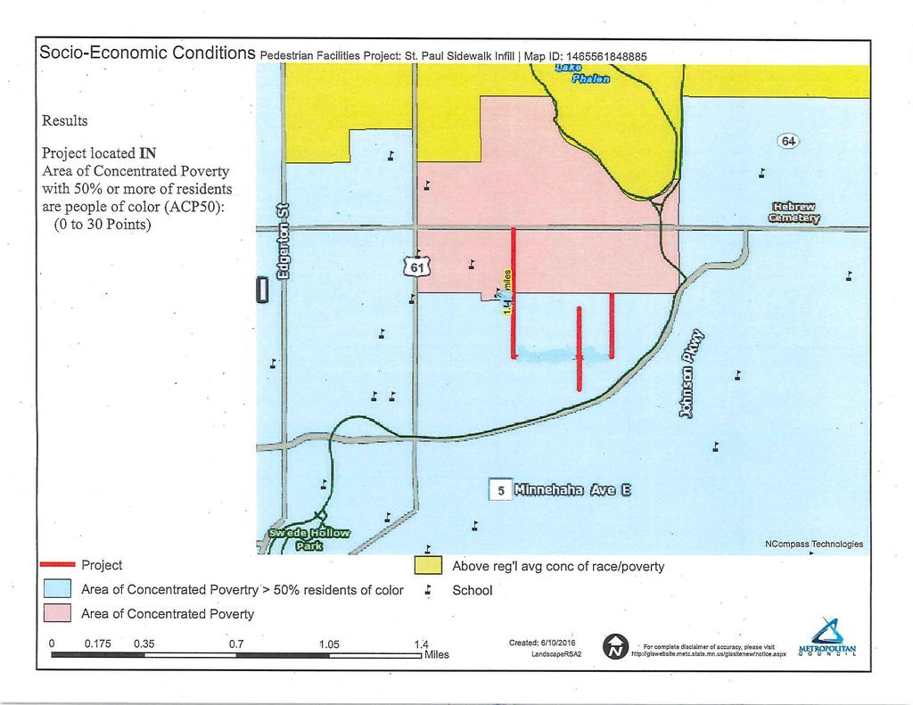
9 Existing Post-Secondary Enrollment: Upload Map _MAP REGION ECON.pdf Measure A: Usage Existing Population Within One-Half Mile Upload Map _MAP POP SUM.pdf Measure A: Project Location and Impact to Disadvantaged Populations Select one: Project located in Area of Concentrated Poverty with 50% or more of residents are people of color (ACP50): Yes Project located in Area of Concentrated Poverty: Projects census tracts are above the regional average for population in poverty or population of color: Project located in a census tract that is below the regional average for population in poverty or populations of color or includes children, people with disabilities, or the elderly:
10 This areas lack of north/south connector sidewalks creates problems for pedestrians traveling through the neighborhood to their destinations. Pedestrians will need to take routes out of their way to stay on city walks or have to start walking in the street. Destinations like Phalen Lakes Hmong School, the Duluth/Case Rec Center, and the Bruce Vento Regional Trail are more difficult to get to due to the missing sidewalks. Getting to the MTC transit on Maryland Avenue is also a concern. Response (Limit 2,800 characters; approximately 400 words) The properties affected by the new construction will lose some mature trees to accommodate the new walk. Some properties will have small retaining walls installed to solve slope issues. Those properties will also have to shovel the walks in the winter. Many of the PED ramps are over twenty years old and need to be updated to the newer ADA standards. This improvement will help people with disabilities traveling throughout the neighborhood. The response should address the benefits, impacts, and mitigation for the populations affected by the project. Upload Map _MAP SOCIO-ECON.pdf Measure B: Affordable Housing City/Township Segment Length in Miles (Population) Saint Paul Total Project Length Total Project Length (Total Population) 1.4 Affordable Housing Scoring - To Be Completed By Metropolitan Council Staff
11 City/Township Segment Length (Miles) Total Length (Miles) Score Segment Length/Total Length Housing Score Multiplied by Segment percent Affordable Housing Scoring - To Be Completed By Metropolitan Council Staff Total Project Length (Miles) 1.4 Total Housing Score 0 Measure A: Gaps, Barriers and Continuity/Connections Response (Limit 2,800 characters; approximately 400 words): The direct connections to the Bruce Vento Trail in this area are at Wells St., Earl St., Frank St., the parking lot of Duluth/Case Rec Center, and Magnolia Ave. The majority of this neighborhood has to rely on accessing the trail mainly using Frank St. and Duluth St. These connectors are fragmented. Sidewalk infill on Frank Street and Duluth Street will reduce the risks associated with the need of traveling on the streets. There is no direct connection to the MTC transit on Cypress Street. People with disabilities will have safer pathways due to the infill of the sidewalk gaps and also with the improved updated PED ramps. Measure B: Project Improvements
12 Total crashes inclusive of boundary streets for all years is is 1,613 crashes. 54 of the 1,613 were pedestrian related. Response (Limit 2,800 characters; approximately 400 words) Total crashes inclusive of boundary streets for (most recent 3 years is) of the 410 were pedestrian related. This information is for the area in question and not for any particular intersections. No other information is available. Measure A: Multimodal Elements and Connections Response (Limit 2,800 characters; approximately 400 words) There are no transit or bicycle elements as part of this application. Nearest transit routes are on Arcade Street and Maryland Avenue. The Bruce Vento Regional Trail runs along south and east side of this neighborhood. The sidewalk infill helps connect the pedestrian travelers on the north/south connections. This will help them get to the transit routes on Maryland Ave. as well as connecting to the Bruce Vento trail. Transit Projects Not Requiring Construction If the applicant is completing a transit or TDM application that is operations only, check the box and do not complete the remainder of the form. These projects will receive full points for the Risk Assessment. Park-and-Ride and other transit construction projects require completion of the Risk Assessment below. Check Here if Your Transit Project Does Not Require Construction Measure A: Risk Assessment 1)Project Scope (5 Percent of Points) Meetings or contacts with stakeholders have occurred
13 Stakeholders have been identified Yes 40% Stakeholders have not been identified or contacted 0% 2)Layout or Preliminary Plan (5 Percent of Points) Layout or Preliminary Plan completed Layout or Preliminary Plan started Yes 50% Layout or Preliminary Plan has not been started 0% Anticipated date or date of completion 12/31/2018 3)Environmental Documentation (5 Percent of Points) EIS EA PM Document Status: Document approved (include copy of signed cover sheet) Document submitted to State Aid for review 75% date submitted Document in progress; environmental impacts identified; review request letters sent 50% Document not started Yes 0% Anticipated date or date of completion/approval 12/31/2018 4)Review of Section 106 Historic Resources (10 Percent of Points) No known historic properties eligible for or listed in the National Register of Historic Places are located in the project area, and project is not located on an identified historic bridge Yes Historic/archeological review under way; determination of no historic properties affected or no adverse effect anticipated 80% Historic/archaeological review under way; determination of adverse effect anticipated 40% Unsure if there are any historic/archaeological resources in the project area
14 0% Anticipated date or date of completion of historic/archeological review: Project is located on an identified historic bridge 5)Review of Section 4f/6f Resources (10 Percent of Points) 4(f) Does the project impacts any public parks, public wildlife refuges, public golf courses, wild & scenic rivers or public private historic properties? 6(f) Does the project impact any public parks, public wildlife refuges, public golf courses, wild & scenic rivers or historic property that was purchased or improved with federal funds? No Section 4f/6f resources located in the project area Yes No impact to 4f property. The project is an independent bikeway/walkway project covered by the bikeway/walkway Negative Declaration statement; letter of support received Section 4f resources present within the project area, but no known adverse effects 80% Project impacts to Section 4f/6f resources likely coordination/documentation has begun 50% Project impacts to Section 4f/6f resources likely coordination/documentation has not begun 30% Unsure if there are any impacts to Section 4f/6f resources in the project area 0% 6)Right-of-Way (15 Percent of Points) Right-of-way, permanent or temporary easements not required Yes Right-of-way, permanent or temporary easements has/have been acquired Right-of-way, permanent or temporary easements required, offers made 75% Right-of-way, permanent or temporary easements required, appraisals made 50% Right-of-way, permanent or temporary easements required, parcels identified 25%
15 Right-of-way, permanent or temporary easements required, parcels not identified 0% Right-of-way, permanent or temporary easements identification has not been completed 0% Anticipated date or date of acquisition 7)Railroad Involvement (25 Percent of Points) No railroad involvement on project Yes Railroad Right-of-Way Agreement is executed (include signature page) Railroad Right-of-Way Agreement required; Agreement has been initiated 60% Railroad Right-of-Way Agreement required; negotiations have begun 40% Railroad Right-of-Way Agreement required; negotiations not begun 0% Anticipated date or date of executed Agreement 8)Interchange Approval (15 Percent of Points)* *Please contact Karen Scheffing at MnDOT or ) to determine if your project needs to go through the Metropolitan Council/MnDOT Highway Interchange Request Committee. Project does not involve construction of a new/expanded interchange or new interchange ramps Yes Interchange project has been approved by the Metropolitan Council/MnDOT Highway Interchange Request Committee Interchange project has not been approved by the Metropolitan Council/MnDOT Highway Interchange Request Committee 0% 9)Construction Documents/Plan (10 Percent of Points) Construction plans completed/approved (include signed title sheet) Construction plans submitted to State Aid for review 75% Construction plans in progress; at least 30% completion
16 50% Construction plans have not been started Yes 0% Anticipated date or date of completion 12/31/ )Letting Anticipated Letting Date 12/30/2020 Measure A: Cost Effectiveness Total Project Cost (entered in Project Cost Form): $1,080, Enter Amount of the Noise Walls: $0.00 Total Project Cost subtract the amount of the noise walls: $1,080, Points Awarded in Previous Criteria Cost Effectiveness $0.00 Other Attachments File Name Description File Size St. Paul Map Infill.pdf The attached map helps highlight the Bruce Vento Trail, the Duluth Playground, and the Phalen Lake Hmong 40 KB School. Also included is the nearest MTC Transit lines.
17
18
19
20
Primary Contact. Organization Information. Application Multiuse Trails and Bicycle Facilities Lake Waconia Regional Trail
 Application 04786-2016 Multiuse Trails and Bicycle Facilities 05088 - Lake Waconia Regional Trail Regional Solicitation - Bicycle and Pedestrian Facilities Status: Submitted Date: Submitted 07/15/2016
Primary Contact. Organization Information. Application Multiuse Trails and Bicycle Facilities
 Application 04786-2016 Multiuse Trails and Bicycle Facilities 05294 - W 36th St Pedestrian and Bicycle Connection Regional Solicitation - Bicycle and Pedestrian Facilities Status: Submitted Date: Submitted
Primary Contact. Organization Information. Application Multiuse Trails and Bicycle Facilities Fish Hatchery Trail Reconstruction
 Application 04786-2016 Multiuse Trails and Bicycle Facilities 05260 - Fish Hatchery Trail Reconstruction Regional Solicitation - Bicycle and Pedestrian Facilities Status: Submitted Date: Submitted 07/15/2016
Primary Contact. Organization Information. Application Safe Routes to School Infrastructure
 Application 04788-2016 Safe Routes to School Infrastructure 05195 - Norwood Young America US212 Safety Improvement Project Regional Solicitation - Bicycle and Pedestrian Facilities Status: Submitted Date:
Primary Contact. Organization Information. Application Multiuse Trails and Bicycle Facilities CSAH 5/Stonebridge Trail Connection
 Application 04786-2016 Multiuse Trails and Bicycle Facilities 05269 - CSAH 5/Stonebridge Trail Connection Regional Solicitation - Bicycle and Pedestrian Facilities Status: Submitted Date: Submitted 07/15/2016
Primary Contact. Organization Information. Application Multiuse Trails and Bicycle Facilities
 Application 04786-2016 Multiuse Trails and Bicycle Facilities 05419 - West St. Paul Oakdale and Marie Bicycle and Pedestrian Improvements Regional Solicitation - Bicycle and Pedestrian Facilities Status:
Primary Contact. Organization Information. Application Multiuse Trails and Bicycle Facilities
 Application 135-218 Multiuse Trails and Bicycle Facilities 1142 - Robert Piram Regional Trail Grade Separation at Barge Channel Rd Regional Solicitation - Bicycle and Pedestrian Facilities Status: Submitted
Primary Contact. Organization Information. Application Safe Routes to School Infrastructure Expo Area Schools SRTS-2016 Appln
 Application 04788-2016 Safe Routes to School Infrastructure 05429 - Expo Area Schools SRTS-2016 Appln Regional Solicitation - Bicycle and Pedestrian Facilities Status: Submitted Date: Submitted 07/15/2016
Chapter 5 Future Transportation
 Chapter 5 Future Transportation The Future Land Use Plan identifies the desired land use designations. The land uses desired for Crozet depend, in large part, on the success of the transportation system,
Brooklyn Boulevard (County Road 152) Reconstruction Project Phase I. OPEN HOUSE June 20, 2017
 Reconstruction Project Phase I. OPEN HOUSE June 20, 2017") Brooklyn Boulevard (County Road 152) Reconstruction Project Phase I OPEN HOUSE June 20, 2017 Brooklyn Boulevard (County Road 152) Phase I Project Partners Project Lead Other Project Partners include Brooklyn
Brooklyn Boulevard (County Road 152) Reconstruction Project Phase I OPEN HOUSE June 20, 2017 Brooklyn Boulevard (County Road 152) Phase I Project Partners Project Lead Other Project Partners include Brooklyn
City of Moorhead Committee of the Whole Meeting
 City of Moorhead Committee of the Whole Meeting Corridor Study Limits Center Avenue (Red River to 8th Street) TH 10 (Red River to TH 336) TH 75 (20th Ave S to Main Avenue) 2 Study Need: Project Overview
West Dimond Blvd Upgrade Jodhpur Street to Sand Lake Road
 West Dimond Blvd Jodhpur St to Sand Lake CSS Transportation Project Summary Municipality of Anchorage Project # 05 005 Project Manager: John Smith, P.E. (MOA PM&E) Project Administrator: Julie Makela,
Living Streets Policy
 Living Streets Policy Introduction Living streets balance the needs of motorists, bicyclists, pedestrians and transit riders in ways that promote safety and convenience, enhance community identity, create
New Measure A Expenditure Categories DEFINITIONS OF ELIGIBLE EXPENDITURES Adopted March 8, 2007
 New Measure A Expenditure Categories DEFINITIONS OF ELIGIBLE EXPENDITURES Adopted March 8, 2007 City Street and County Road Maintenance Program The preservation and keeping of public street and road rights-of-way
NJDOT Complete Streets Checklist
 Background The New Jersey Department of Transportation s Complete Streets Policy promotes a comprehensive, integrated, connected multi-modal network by providing connections to bicycling and walking trip
5. RUNNINGWAY GUIDELINES
 5. RUNNINGWAY GUIDELINES These guidelines should be considered collectively when making runningway decisions. A runningway is the linear component of the transit system that forms the right-of-way reserved
City of Madison, East Johnson Street North Baldwin Street to First Street Local Street Dane County
 City of Madison, East Johnson Street North Baldwin Street to First Street Local Street Dane County Public Involvement Meeting Thursday, November 10, 2016 5:30 to 7 P.M. Festival Foods 810 E. Washington
APPENDIX A: Complete Streets Checklist DRAFT NOVEMBER 2016
 APPENDIX A: Complete Streets Checklist DRAFT NOVEMBER 2016 Complete Streets Checklist MetroPlan Orlando s Complete Streets Checklist is an internal planning tool for staff to further implementation of
3.9 Recreational Trails and Natural Areas
 3.9 Recreational Trails and Natural Areas 3.9.1 Introduction Parks and other recreational facilities such as trails, bicycle routes, and open space are important community resources. This section discusses
POLICY ADVISORY COMMITTEE
 September 27, 2018 POLICY ADVISORY COMMITTEE ENVIRONMENTAL ANALYSIS PHASE Agenda 1. Welcome and introductions. 2. Overview of project activities and process. 3. Public engagement update. 4. Community Advisory
TRANSPORTATION COMMISSION Agenda Staff Report
 TRANSPORTATION COMMISSION Agenda Staff Report Agenda Item No. 5.a DATE: JULY 31, 2014 TO: FROM: SUBJECT: TRANSPORTATION COMMISSION COMMUNITY DEVELOPMENT DEPARTMENT - PLANNING DRAFT OLYMPIC CORRIDOR PREFERRED
CHAPTER 16 PEDESTRIAN FACILITIES DESIGN AND TECHNICAL CRITERIA TABLE OF CONTENTS
 CHAPTER 16 PEDESTRIAN FACILITIES DESIGN AND TECHNICAL CRITERIA TABLE OF CONTENTS Section Title Page 16.1 General... 16-1 16.1.1 AASHTO Reference... 16-1 16.1.2 ADA Requirements... 16-1 16.2 Sidewalks...
Clackamas County Comprehensive Plan
 ROADWAYS The County s road system permits the movement of goods and people between communities and regions, using any of a variety of modes of travel. Roads provide access to virtually all property. They
Reams Road RCA Study. Board of County Commissioners Public Hearing
 Reams Road RCA Study Board of County Commissioners Public Hearing April 24, 2018 Presentation Overview Study Overview Existing Conditions Development of Alternatives Preferred Alternative Public Involvement
Bicycle and Pedestrian Chapter TPP Update Overview. TAB September 20, 2017
 Bicycle and Pedestrian Chapter TPP Update Overview TAB September 20, 2017 Bicycling & Walking in the Twin Cities Where are we now? The Bike-Pedestrian system Current trends New developments Where are we
St. Francis Drive through the City of Santa Fe Corridor Study
 VII. ENGINEERING AND ENVIRONMENTAL EVALUATION TRAIL CONNECTIVITY In the southern portion of the Corridor there is a lack of a sidewalk, trail or bicycle facility within the right-ofway. However, the City
DRAFT. Table of Contents. Background
 Douglas County Table of Contents Existing Infrastructure 86 Funding 89 Policy and Program Recommendations 90 Infrastructure Recommendations 92 Conclusion 95 Background Home to 4,500 residents and Baker
City of Madison, East Johnson Street North Baldwin Street to First Street Local Street Dane County
 City of Madison, East Johnson Street North Baldwin Street to First Street Local Street Dane County Public Involvement Meeting Thursday, April 28, 2016 6 to 8 P.M. Lapham Elementary School 1045 E. Dayton
CITY OF KASSON TRANSPORTATION ALTERNATIVES KASSON SAFE ROUTES TO SCHOOL
 ve ha 8t G B A Mantorville Ave N 240th Ave 16th St NE 11th Ave NE K-M HIGH SCHOOL SUNRISE TRAIL TO MANTORVILLE MNTH 57 SUNSET TRAIL TO MANTORVILLE NE PARK 16TH ST NE TRAIL K-M ELEMENTARY SCHOOL K-M MIDDLE
A Matter of Fairness: ROCOG s Environmental Justice Protocol. What is Mobility Limitation?
 No Person Left Behind What is Mobility Limitation? What is the Access Limitation? Environmental Justice population should be provided adequate mobility & access to meet their needs; Identify acceptable
Solana Beach Comprehensive Active Transportation Strategy (CATS)
") Solana Beach Comprehensive Active Transportation Strategy (CATS) 3.0 Goals & Policies The Solana Beach CATS goals and objectives outlined below were largely drawn from the Solana Beach Circulation Element
Solana Beach Comprehensive Active Transportation Strategy (CATS) 3.0 Goals & Policies The Solana Beach CATS goals and objectives outlined below were largely drawn from the Solana Beach Circulation Element
Poor pavement condition Substandard Intersections. / Substandard bike/pedestrian/transit accommodations. Driveway access Environmental concerns
 Public Informational Meeting University Avenue (Allen Boulevard Segoe Road) March 23, 2011 City of Madison City of Middleton Village of Shorewood Hills Dane County Existing Roadway Conditions Poor pavement
SR-203 Sidewalks and Town-Wide Mobility Improvements. Town Council Presentation September 7, 2016
 SR-203 Sidewalks and Town-Wide Mobility Improvements Town Council Presentation September 7, 2016 SR-203 Sidewalks and Town- Wide Mobility Improvements SR-203 Sidewalks and Appurtenances Town-Wide Mobility
TRANSPORTATION & MOBILITY
 TRANSPORTATION & MOBILITY ROADWAY SYSTEM There are approximately 40 miles of roadways in Manitou Springs. For planning purposes, roadways are typically assigned a functional classification which defines
AMATS Complete Streets Policy
 AMATS Complete Streets Policy Table of Contents: Section 1. Definition of Complete Streets Section 2. Principles of Complete Streets Section 3. Complete Streets Policy Section 4. Consistency Section 5.
PRESS RELEASE San Joaquin Council of Governments
 PRESS RELEASE San Joaquin Council of Governments For Immediate Release February 23, 2018 Contact: Nicole Gorham, 235-0582 gorham@sjcog.org SJCOG Board Awards $19.63 Million in Measure K Bicycle, Pedestrian,
Street Paving and Sidewalk Policy
 City Commission Policy 600 Street Paving and Sidewalk Policy DEPARTMENT: Public Works DATE ADOPTED: June 7, 1995 DATE OF LAST REVISION: December 10, 2014 Policy No. 600.01 AUTHORITY: PASS City of Tallahassee-Leon
Preliminary Engineering Study
 Preliminary Engineering Study Open House # 2 June 6, 2018 PREPARED FOR: PREPARED BY: Agenda Background and status of preliminary engineering study County Road 26 design summary County Road 63 design summary
ACTION TRANSMITTAL No
 Transportation Advisory Board of the Metropolitan Council of the Twin Cities ACTION TRANSMITTAL No. 2014-63 DATE: September 5, 2014 TO: Funding & Programming Committee PREPARED BY: Joe Barbeau, Senior
Chapter 13 ORANGE COVE
 Chapter 13 ORANGE COVE This chapter describes the current status and future plans for biking and walking in the City of Orange Cove. RELATIONSHIP TO CITY PLANS AND POLICIES The Orange Cove General Plan
CITY OF BLOOMINGTON COMPLETE STREETS POLICY
 CITY OF BLOOMINGTON COMPLETE STREETS POLICY POLICY OBJECTIVE: The City of Bloomington will enhance safety, mobility, accessibility and convenience for transportation network users of all ages and abilities,
VDOT I-66 Inside the Beltway Eastbound Widening Environmental Assessment. Staff Recommendations
 VDOT I-66 Inside the Beltway Eastbound Widening Environmental Assessment Staff Recommendations Department of Environmental Services Transportation January 28, 2017 Timeline of Transform66 June 2012: I-66
General Plan Circulation Element Update Scoping Meeting April 16, 2014 Santa Ana Senior Center, 424 W. 3rd Street, Santa Ana, CA 92701
 General Plan Circulation Element Update Scoping Meeting April 16, 2014 Santa Ana Senior Center, 424 W. 3rd Street, Santa Ana, CA 92701 Meeting Agenda 1. Purpose of Scoping Meeting 2. Project Overview 3.
Overview. Illinois Bike Summit IDOT Complete Streets Policy Presentation. What is a Complete Street? And why build them? And why build them?
 Overview Illinois Bike Summit IDOT Complete Streets Policy Presentation Aren Kriks, P.E. District One Bicycle Coordinator and Bureau of Programming Project Engineer History of Complete Streets IDOT Policy
4APNOIPF Vh, YII PTC CITY COUNCIL AGENDA REPORT. Honorable Mayor and City Council Members. 8K TH 63 River Crossing Bridge Replacement Project
 City of RE 4APNOIPF Vh, X` W\ YII PTC ING, CITY COUNCIL AGENDA REPORT Council Meeting Date: September 26, 2016 To: From: Agenda Item: Honorable Mayor and City Council Members Ron Rosenthal, Engineering
CITY OF COCOA BEACH 2025 COMPREHENSIVE PLAN. Section VIII Mobility Element Goals, Objectives, and Policies
 CITY OF COCOA BEACH 2025 COMPREHENSIVE PLAN Section VIII Mobility Element Goals, Objectives, and Policies Adopted August 6, 2015 by Ordinance No. 1591 VIII MOBILITY ELEMENT Table of Contents Page Number
Gordon Proctor Director Policy on Accommodating Bicycle and Pedestrian Travel on ODOT Owned or Maintained Facilities
 Approved: Policy: 20-004(P) Responsible Office: Planning Gordon Proctor Director Policy on Accommodating Bicycle and Pedestrian Travel on ODOT Owned or Maintained Facilities I. POLICY STATEMENT: This policy
6.0 PEDESTRIAN AND BICYCLE FACILITIES 6.1 INTRODUCTION 6.2 BICYCLE DEMAND AND SUITABILITY Bicycle Demand
 6.0 PEDESTRIAN AND BICYCLE FACILITIES 6.1 INTRODUCTION Bicycle and pedestrian travel along and in the vicinity of the corridor is part of the vision of Somerset and Hunterdon counties and the integrated
Agenda. Overview PRINCE GEORGE S PLAZA METRO AREA PEDESTRIAN PLAN
 PRINCE GEORGE S PLAZA METRO AREA PEDESTRIAN PLAN May 28, 2008 Agenda Welcome and introductions Project overview and issue identification Planning context and strengths Design challenges and initial recommendations
CONNECTIVITY PLAN. Adopted December 5, 2017 City of Virginia Beach
 CONNECTIVITY PLAN Adopted December 5, 2017 City of Virginia Beach CONTENTS 1.0 Background & Purpose... 2 2.0 Existing Inventory & Analysis... 3 ViBe District Existing Walking Conditions... 4 3.0 ViBe District
Chapter 9: Pedestrians and Bicyclists
 Chapter 9: Pedestrians and Bicyclists Walking and bicycling are essential modes of transportation. These modes allow people to travel without contributing to congestion and air pollution, to access other
Non-Motorized Transportation 7-1
 Non-Motorized Transportation 7-1 Transportation facilities no longer mean just accommodating a vehicle powered by a combustion engine. Pedestrian and non-motorized facilities are important modes of travel
AMENDING MOTION: Mobility Plan - Pedestrians and Disadvantaged Communities
 I MOVE that the Council: AMENDING MOTION: Mobility Plan - Pedestrians and Disadvantaged Communities 1. INSTRUCT the Department of City Planning to amend the proposed Mobility Plan to include the following;
Chapter 14 PARLIER RELATIONSHIP TO CITY PLANS AND POLICIES. Recommendations to Improve Pedestrian Safety in the City of Parlier (2014)
") Chapter 14 PARLIER This chapter describes the current status and future plans for biking and walking in the City of Parlier. RELATIONSHIP TO CITY PLANS AND POLICIES The Parlier General Plan is the primary
Chapter 14 PARLIER This chapter describes the current status and future plans for biking and walking in the City of Parlier. RELATIONSHIP TO CITY PLANS AND POLICIES The Parlier General Plan is the primary
RZC Appendix 8A Marymoor Subarea Street Requirements
 RZC Appendix 8A Marymoor Subarea Street Requirements For additional design details for Marymoor Subarea infrastructure, refer to the 2017 Marymoor Subarea Infrastructure Planning Report. STREET REQUIREMENTS
Philip Schaffner Minnesota Department of Transportation October 22, 2013
 Philip Schaffner Minnesota Department of Transportation October 22, 2013 Going beyond performance measures & targets MnDOT has been using performance-based planning and programming for 10 years, but CIMS
Improvements Infrastructure Gap Assessment and Improvements Street Striping
 Infrastructure Project Proposal The federal-aid Safe Routes to School program funds infrastructure/engineering projects that fall into two categories: Design (available only to School Development Authority
ADA TRANSITION PLAN 2013
 ADA TRANSITION PLAN 2013 TABLE OF CONTENTS Contents Introduction 1 Purpose 2 Identified Obstacles to the Public Right of Way 3 Criteria for Determining Impediments at Village Facilities 4 Removing Barriers
MAG Town of Cave Creek Bike Study Task 6 Executive Summary and Regional Significance Report
 Page 1 MAG Town of Cave Creek Bike Study Task 6 Executive Summary and Regional Significance Report August 1, 2012 MAG Project #481 Page 2 Task 6 Executive Summary and Regional Significance Report Introduction
ADOT Statewide Bicycle and Pedestrian Program Summary of Phase IV Activities APPENDIX B PEDESTRIAN DEMAND INDEX
 ADOT Statewide Bicycle and Pedestrian Program Summary of Activities APPENDIX B PEDESTRIAN DEMAND INDEX May 24, 2009 Pedestrian Demand Index for State Highway Facilities Revised: May 29, 2007 Introduction
This page intentionally left blank.
 This page intentionally left blank. COMMUNITY Glenpool Community Overview Glenpool Glenpool is a city of nearly 12,000 residents located in Tulsa County southwest of Tulsa and Jenks. The city is growing
RESOLUTION NO ?? A RESOLUTION OF THE CITY OF NEPTUNE BEACH ADOPTING A COMPLETE STREETS POLICY
 RESOLUTION NO. 2018-?? A RESOLUTION OF THE CITY OF NEPTUNE BEACH ADOPTING A COMPLETE STREETS POLICY WHEREAS, safe, convenient, and accessible transportation for all users is a priority of the City of Neptune
Americans with Disabilities Act Transition Plan for Public Right-of-Way Improvements
 Americans with Disabilities Act Transition Plan for Public Right-of-Way Improvements Prepared by: Public Works Department Engineering Division October 2015 Table of Contents Section I Introduction.. 3
Lee s Summit Road Improvement Study Public Open House June 7, 2007 Summary of Comment Card Responses
 Lee s Summit Road Improvement Study Public Open House June 7, 2007 Summary of Comment Card Responses Introduction At the Lee s Summit Road Improvement Study Public Open House held Thursday, June 7, 2007
Giles Run Connector Road
 Giles Run Connector Road Laurel Hill Adaptive Reuse Area to Laurel Crest Drive South County Federation Meeting June 14, 2016 History Connector road included in the Laurel Hill Comprehensive Plan amendment
Perryville TOD and Greenway Plan
 Perryville TOD and Greenway Plan Greenway Glossary Pathway: A bicycle and pedestrian path separated from motorized vehicular traffic by an open space, barrier or curb. Multi-use paths may be within the
TRANSPORTATION TRAINING TOPICS. April 6, 2010
 TRANSPORTATION TRAINING TOPICS April 6, 2010 Roles of Transportation Providers Context and Policy Makers Division of Transportation and Traffic Other City Operations Other Transportation Operators CMA
4. ENVIRONMENTAL IMPACT ANALYSIS 9. TRANSPORTATION AND TRAFFIC
 4. ENVIRONMENTAL IMPACT ANALYSIS 9. TRANSPORTATION AND TRAFFIC 4.9.1 INTRODUCTION The following section addresses the Proposed Project s impact on transportation and traffic based on the Traffic Study
PROPOSED BICYCLE AND PEDESTRIAN FACILITY Vicinity of Route 123/I-495 Interchange Tysons, Fairfax County, Virginia
 PROPOSED BICYCLE AND PEDESTRIAN FACILITY Vicinity of Route 123/I-495 Interchange Tysons, Fairfax County, Virginia PRELIMINARY ENGINEERING REPORT Prepared for: Prepared by: July 2017 Table of Contents 1
STATE AID FOR LOCAL TRANSPORTATION Rev. July 2010 De MINIMIS WRITE-UP FOR PM For parks, recreation areas, wildlife or waterfowl refuges Page 1 of 3
 SECTION 4(f) STATE AID FOR LOCAL TRANSPORTATION Rev. July 2010 For parks, recreation areas, wildlife or waterfowl refuges Page 1 of 3 The Safe, Accountable, Flexible, Efficient Transportation Equity Act:
Project Status Update
 Project Status Update : Novato Boulevard, 4th & 3rd Streets, Sir Francis Drake Boulevard (3), and Miller Avenue Major roads projects target the most heavily traveled roads in Marin County for repairs,
Morristown, NJ Complete Streets Policy
 Morristown, NJ Complete Streets Policy Introduction A Complete Street is defined as a means to provide safe access for all users by designing and operating a comprehensive, integrated, connected multi-modal
REGIONAL BICYCLE AND PEDESTRIAN DESIGN GUIDELINES
 REGIONAL BICYCLE AND PEDESTRIAN DESIGN GUIDELINES November 16, 2011 Deb Humphreys North Central Texas Council of Governments Bicycle and Pedestrian Advisory Committee Snapshot of the Guide 1. Introduction
ACTIVE TRANSPORTATION/NONMOTORIZED TRANSPORTATION
 ACTIVE TRANSPORTATION/NONMOTORIZED TRANSPORTATION BACKGROUND Active transportation, also known as nonmotorized transportation, is increasingly recognized as an important consideration when planning and
Bus Rapid Transit Plans
 Twin Cities Region Bus Rapid Transit Plans ULI Minnesota Workshop Connecting Bus Rapid Transit to the Community December 15, 2009 John Levin Director of Service Development Metro Transit Metropolitan Area
Chapter 4: Funding and Implementation
 Chapter 4: Funding and Implementation 83 84 Cost Estimating Cost estimating is an iterative process. When a project is in the conceptual stage, preliminary cost estimates are also provided conceptually,
Carbondale to Murphysboro Bike Route JACKSON COUNTY
 Carbondale to Murphysboro Bike Route JACKSON COUNTY March, 2017 PREPARED BY: Southern Illinois Metropolitan Organization Table of Contents Introduction... 1 A. Project Purpose and Study Area... 1 B. Previous
ACTIVE TRANSPORTATION
 ACTIVE TRANSPORTATION Mobility 2040 Supported Goals Improve the availability of transportation options for people and goods. Support travel efficiency measures and system enhancements targeted at congestion
S A F E R O U T E S T O S C H O O L H E R M A N TOW N S C H O O L S A N D P R O C TO R S C H O O L S P L A N A P P R OVA L S
 S A F E R O U T E S T O S C H O O L H E R M A N TOW N S C H O O L S A N D P R O C TO R S C H O O L S P L A N A P P R OVA L S WHAT IS SAFE ROUTES TO SCHOOL? In 1969, nearly 50% of children walked or rode
PRINCE GEORGE S PLAZA METRO AREA PEDESTRIAN PLAN
 PRINCE GEORGE S PLAZA METRO AREA PEDESTRIAN PLAN May 28, 2008 Agenda Welcome and introductions Project overview and issue identification Planning context and strengths Design challenges and initial recommendations
APPENDIX G: INTERSECTION NEEDS AT OKEECHOBEE BOULEVARD
 APPENDIX G: INTERSECTION NEEDS AT OKEECHOBEE BOULEVARD INTERSECTION NEEDS AT SR 7 and OKEECHOBEE BOULEVARD SR 7 Extension Project Development and Environment (PD&E) Study From Okeechobee Boulevard (SR
Building Great Neighbourhoods BELLEVUE AND VIRGINIA PARK
 Building Great Neighbourhoods BELLEVUE AND VIRGINIA PARK This is Meeting 2 Unfortunately, some residents in Bellevue and Virginia Park received the wrong information for this public open house (Meeting
Pine Hills Road Pedestrian/Bicycle Safety Study Board of County Commissioners Work Session
 Pine Hills Road Pedestrian/Bicycle Safety Study Board of County Commissioners Work Session February 20, 2018 Meeting Agenda Study Overview Existing Conditions Access Management Potential Gateway Features
NM-POLICY 1: Improve service levels, participation, and options for non-motorized transportation modes throughout the County.
 Transportation PRINCE WILLIAM COUNTY 2008 COMPREHENSIVE PLAN NON-MOTORIZED PLAN CONTENTS Goals, Policies, and Action Strategies Table 4 (Bike Facility Classifications and Descriptions) Table 5 (Bike Facility
ORDINANCE NO
 1 Sponsored by: Councilmembers Stan Flemming, Connie Ladenburg, and Rick Talbert 2 Requested by: Executive/Public Works and Utilities - Transportation Services 3 4 5 6 7 10 11 ORDINANCE NO. 2014-445 12
PEDESTRIAN ACTION PLAN
 ATTACHMENT 2 CITY OF SANTA MONICA PEDESTRIAN ACTION PLAN CITY OF SANTA MONICA PEDESTRIAN ACTION PLAN This page intentionally left blank EXECUTIVE SUMMARY CHAPTER 1 EXECUTIVE SUMMARY Setting the Stage
City of Birmingham Draft Multi-modal Transportation Plan
 City of Birmingham Draft Multi-modal Transportation Plan City Commission Public Hearing Monday, November 25, 2013 7:30 pm Norman Cox, PLA, ASLA The Greenway Collaborative, Inc. Ann Arbor, Michigan The
Welcome to the Open House
 Leslie Street Between 19 th Avenue and Stouffville Road Addendum to Class Environmental Assessment Study Welcome to the Open House Please sign in at the front desk. March 28, 2017 Richmond Green Sports
Item No. 14 Town of Atherton
 Item No. 14 Town of Atherton CITY COUNCIL STAFF REPORT CONSENT AGENDA TO: THROUGH: FROM: HONORABLE MAYOR AND CITY COUNCIL GEORGE RODERICKS, CITY MANAGER MICHAEL KASHIWAGI, COMMUNITY SERVICES DIRECTOR MARTY
APPROVE A RESOLUTION ADOPTING A COMPLETE STREETS POLICY
 STAFF REPORT MEETING DATE: September 13, 2016 TO: FROM: City Council Bob Brown, Community Development Director Russ Thompson, Public Works Director Patrick Filipelli, Management Analyst 922 Machin Avenue
Bicycle-Pedestrian Master Plan: Chapters 3 and 4 Distribution
 Bicycle-Pedestrian Master Plan: Chapters 3 and 4 Distribution Finksburg Planning and Citizens Council March 22, 2018 Overview Progress Citizen Outreach Vision Chapter 3 - Existing Conditions Chapter 4
Phone: Fax: Project Reference No. (to be filled out by MassHighway):
:") Massachusetts Highway Department District 3 Project Need Form (PNF) This form is intended to provide preliminary information about the proposed project. It is not expected that all information that is
Massachusetts Highway Department District 3 Project Need Form (PNF) This form is intended to provide preliminary information about the proposed project. It is not expected that all information that is
SD Highway 50 in Yankton (4 TH Street) Reconstruction Project NH 0050(99)381 PCN By Josh Larson McLaury Engineering Inc.
 Reconstruction Project NH 0050(99)381 PCN By Josh Larson McLaury Engineering Inc.") SD Highway 50 in Yankton (4 TH Street) Reconstruction Project NH 0050(99)381 PCN 6926 By Josh Larson McLaury Engineering Inc. Project Limits SD 50 from Broadway to Burleigh and from Marne Creek to Archery
SD Highway 50 in Yankton (4 TH Street) Reconstruction Project NH 0050(99)381 PCN 6926 By Josh Larson McLaury Engineering Inc. Project Limits SD 50 from Broadway to Burleigh and from Marne Creek to Archery
Proposed. City of Grand Junction Complete Streets Policy. Exhibit 10
 Proposed City of Grand Junction Complete Streets Policy Exhibit 10 1 City of Grand Junction Complete Streets Policy Vision: The Complete Streets Vision is to develop a safe, efficient, and reliable travel
ACTION TRANSMITTAL No
 Transportation Advisory Board of the Metropolitan Council of the Twin Cities DATE: March 12, 2015 TO: ACTION TRANSMITTAL No. 2015-20 TAC Funding and Programming Committee PREPARED BY: Joe Barbeau, Senior
I-290 Phase I Study Area OAK PARK AVE AUSTIN BLVD. Reconstruction Area (9 miles) Oak Park RIDGELAND AVE CENTRAL AVE HARLEM AVE. Cicero.
 Oak Park RIDGELAND AVE CENTRAL AVE HARLEM AVE. Cicero.") RIDGELAND AVE OAK PARK AVE AUSTIN BLVD UP-RR BRC-RR ASHLAND AVE Study Area Map I-290 Phase I Study Area 294 UP RR Metra UP-W Illinois Prairie Path 38 Berkeley WOLF RD Hillside MANNHEIM RD Bellwood 290
RIDGELAND AVE OAK PARK AVE AUSTIN BLVD UP-RR BRC-RR ASHLAND AVE Study Area Map I-290 Phase I Study Area 294 UP RR Metra UP-W Illinois Prairie Path 38 Berkeley WOLF RD Hillside MANNHEIM RD Bellwood 290
Tonight is for you. Learn everything you can. Share all your ideas.
 Strathcona Neighbourhood Renewal Draft Concept Design Tonight is for you. Learn everything you can. Share all your ideas. What is Neighbourhood Renewal? Creating a design with you for your neighbourhood.
City of Wayzata Comprehensive Plan 2030 Transportation Chapter: Appendix A
 A1. Functional Classification Table A-1 illustrates the Metropolitan Council s detailed criteria established for the functional classification of roadways within the Twin Cities Metropolitan Area. Table
Appendix 3 Roadway and Bike/Ped Design Standards
 Appendix 3 Roadway and Bike/Ped Design Standards OTO Transportation Plan 2040 4/20/2017 Page A3-1 Adopted Standards The adopted OTO Design Standards and Major Thoroughfare Plan are contained herein.
HYATTSVILLE TRANSPORTATION PLAN. City Council Update March 19, 2018
 HYATTSVILLE TRANSPORTATION PLAN City Council Update March 19, 2018 AGENDA PROJECT GOALS DATA COLLECTION WHAT WE LEARNED NEXT STEPS PROJECT GOALS Identify bicycle and pedestrian needs of the city Evaluate