MARKET STREET STUDY TECHNICAL REPORT
|
|
|
- Annabella Cameron
- 5 years ago
- Views:
Transcription


1 MARKET STREET STUDY TECHNICAL REPORT BICYCLE LANES BETWEEN EIGHTH and OCTAVIA STREETS This technical report is one of over a dozen reports prepared to support the Market Street Study. The purpose of the technical reports was to identify key issues and evaluate potential solutions. The techincal reports were developed in consultation with the Market Street Study Technical Working Group, which consisted of representatives from the San Francisco Department of Parking and Traffic, Municipal Railway, Planning Department, and Redevelopment Agency. Supplemental assessments may be required prior to the implementation of some specific recommendations contain in the Market Street Study Action Plan.

2 Market Street Study Bicycle Lanes between Eighth and Octavia Streets Technical Report INTRODUCTION The San Francisco County Transportation Authority (Authority) commissioned this study to provide traffic engineering, planning, and related technical analysis focused on multi-modal solutions for Market Street. The intent of the technical work is to enable policymakers to agree upon a recommended set of improvements for Market Street bicycle improvements. This study is intended to generate a sufficient level of confidence in scope and cost to support development of a funding strategy for the recommended improvements. This Technical Memorandum presents a conceptual cost estimate for the physical construction requirements associated with the development of six-foot wide bicycle lanes on Market Street. Project Setting Market Street has the highest volumes of bicycle traffic in the city. A bike count done in July 2002 showed that some sections of the street see bike volumes of over 200 cyclists per hour during the peak periods. The reasons for this are many. It is flat, and it connects the flattest routes in the City. It connects most of the City s existing bicycle lane network, including Upper Market, Polk, the Duboce Bikeway, 8 th, 7 th, Grove, Valencia, 11 th and the Embarcadero. It connects Downtown to the neighborhoods with the highest bicycle usage: the Mission, Castro, Haight, Hayes Valley, and Western Addition. Unlike adjacent streets, it is not important for through automobile traffic and lacks auto-oriented uses like parking garages, parking lots, auto repair shops or driveways. However, Market Street also supports many other transportation modes. It is also the most important transit street in the city, hosting both bus lines and the historic streetcar. Autos use the street to cross from the north-of-market grid to the south-of-market grid. For all these reasons, community and bicycle advocacy groups have long wanted a bicycle lane on Market Street. Ironically, for many of the same reasons, many others feel that a bicycle lane doesn t belong on Market Street. Right-of-way is decidedly limited, especially in the Financial District, and particularly in the curb lane adjacent to transit boarding islands. Significant capital investment has been made to make Market Street the transit street that it is, and to give it the appearance that is has. MUNI in general discourages the placement of bicycle facilities on transit streets because of the increased likelihood of bicycle/bus conflicts. Autos will continue to use Market Street for the connectivity it provides. The only street access that many commercial operations have is on Market Street, necessitating the presence of freight traffic. The following sections illustrate lane configurations, sidewalk widths, and current operational space for bicyclists at two specific locations, one west of Van Ness where sidewalks are narrower, and one east of Van Ness where sidewalks widen. Page 1 of 20

3 PROJECT BACKGROUND The bicycle improvement recommendations of this study should be considered in the context of several related and overlapping planning efforts. Each of these related and overlapping projects will influence Market Street in the short-, medium- and long-term. The most relevant plans and their significance are discussed below. Market Street Study This study was initiated by the San Francisco County Transportation Authority in May, The results of the study presented in this Draft Technical Memorandum will be integrated into the large multi-modal study to be completed in The multi-modal study will address transit operation, vehicular circulation, bicycle circulation, and pedestrian safety improvements. San Francisco Bicycle Plan Update The San Francisco Department of Parking and Traffic Bicycle Program is responsible for completion of the Update to the San Francisco Bicycle Plan. Two important aspects of the Plan Update are the Priority Projects and the Supplemental Design Guidelines, both of which influence any bicycle-related improvements on Market Street. The Priority Projects in the Plan Update represent the highest priority implementation projects for the five-year planning cycle following plan adoption. Market Street was identified by the public and through the planning process as one of these Priority Projects. The Supplemental Design Guidelines represent an effort by the Department of Parking and Traffic Bicycle Program to incorporate recent nationwide and international innovations in bicycle facility engineering into the City s design standards. Numerous design concepts currently being reviewed for adoption by the Bicycle Plan Update Technical Advisory Committee are recommended for implementation on Market Street. These bicycle facilities are discussed in greater detail below under Design Standards in this Draft Technical Memorandum. Page 2 of 20
4 All bicycle standards identified in this report must be cross-referenced with the Bicycle Plan Update Supplemental Design Guidelines to determine the current status of each standard. All are currently in draft form and may be modified through the Department of Parking and Traffic staff review process and through ISCOTT approval. Central Freeway/Octavia Boulevard Project As of the writing of this Draft Technical Memorandum, implementation of the new freeway touch-down at Market Street is in the final stages of engineering design by Caltrans and the Department of Parking and Traffic. Fine-tuning and design adjustments to lane configurations, signal timing, sidewalk and bike path configuration are currently under discussion between various stakeholders as of the writing of this Draft Technical Memorandum. Current issues not yet resolved that will influence implementation of the recommendation of this Technical Memorandum include: Bicycle lane configuration at east bound Market Street and the freeway touch down ramp. Integration of the proposed McCoppin bicycle pathway and the proposed sidewalk/crosswalk design from south of Market to Octavia Boulevard The Market and Octavia Neighborhood Plan The Market and Octavia Neighborhood Plan area encompasses the western half of the project area covered in this Draft Technical Memorandum, from Octavia to Van Ness. Chapter 5 of the neighborhood plan emphasizes Balancing Transportation Choices, and specifically addresses improving the area s bicycle network. The plan recommends bicycle lanes on Market Street from Octavia Boulevard east to 8 th Street. DESIGN STANDARDS Market Street is a complex environment requiring innovative engineering solutions to provide for bicycle circulation improvements and to ensure that impacts to other modes are minimized. This study recommends that a variety of design solution should be employed along Market from 8 th to Octavia. The following section provides a brief discussion of some of the recommended design solutions. For each treatment, this section provides the term or name of the treatment, the general intended benefit, and examples of where and how the treatment has been used in the Unites State and elsewhere. Bicycle Lanes Generally speaking, a bicycle lane is an on-street facility for bicycles demarcated by a solid white stripe of 4 inches or greater width, legally established for bicycle circulation in the same direction as vehicle travel. Typically, the bicycle lane is located on the right hand side of the roadway adjacent to the curb or located between the rightmost travel lane and curbside parking. The California Vehicle Code (CVC) establishes the legal framework for operation of a bicycle on roadways in general, and specifically within a bicycle lane. Section establishes that when a bicycle lane has been established on a roadway any person operating a bicycle upon the roadway at a speed less than the normal speed of traffic moving in the same direction at that time shall ride within the bicycle lane, except that the person may move out of the lane under any of the following situations: overtaking and passing another bicycle, vehicle, or pedestrian within the lane or about to enter the lane if the overtaking and passing cannot be done safely within the lane. when preparing for a left turn at an intersection or into a private road or driveway. when reasonably necessary to leave the bicycle lane to avoid debris or other hazardous conditions. when approaching a place where a right turn is authorized Page 3 of 20
5 Bicycle lane widths and striping patterns are governed by Caltrans Chapter 1000 Bikeway Planning and Design and AASHTO Guide for the Development of Bicycle Facilities. Both documents provide for bicycle lane widths, location of bicycle lanes with respect to curb and parking lanes, guidelines for intersection treatments, and guidelines for lane stripe widths and dashing at intervals. In California, on-street one way striped bicycle lanes are referred to as Class II bicycle facilities under Caltrans Chapter The decision to implement continuous bicycle lanes is addressed as follows in Caltrans Chapter 1000: The decision to develop bikeways should be made with the knowledge that bikeways are not the solution to all bicyclerelated problems The development of well conceived bikeways can have a positive effect on bicyclist and motorist behavior. Conversely, poorly conceived bikeways can be counterproductive to education and enforcement programs. With this admonition in mind, implementation of a continuous bicycle lane along Market Street is carefully considered in this project. Bicycle lane widths and travel lane widths are addressed in the San Francisco Bicycle Plan Supplemental Design Guidelines. Bicycle Lanes with Buffers Bicycle lanes that are separated or buffered from adjacent travel lanes are not frequently used in the United States but have been used in some European cities. A buffer can consist of a striped zone indicating that neither bicycles nor vehicles should not operate in this area, or a physical barrier such as an elevated curb or landscaped zone. As with a standard bicycle lane, a bicycle lane with buffer is a one-way facility. There are no existing guidelines for buffers established in the United States, but technical issues that require consideration, particularly for physical buffers, include location of the buffer in relationship to parked vehicles, location of gaps in the buffer to allow for lane changes and entry and exit by bicyclists, and appropriate initiation/discontinuation of buffers in relationship to intersections and driveways. Use of additional striping or paint as a buffer would require annual maintenance and potentially annual replacement depending on location and level of impact associated with crossing or turning vehicle traffic. If an elevated buffer is advocated in place of a striped or painted buffer, greater maintenance requirements should be acknowledged. Street sweeping using standard street equipment will not be possible, and additional route for the smaller scale sidewalk and pathway sweepers would be required. Existing pathway sweeping routes are mapped and maintained by the San Francisco Department of Parking and Traffic Bicycle Program and the Department of Public Works. Colored Bicycle Lanes Colored bicycle lanes are used in Portland, Oregon, and in various European cities to increase visibility of the bicycle lane and to increase compliance with the intended facility use. Colored bicycle lanes for potential high conflict areas are the predominant use in the United States. Colored bicycle lanes are being analyzed in the San Francisco Bicycle Plan Update. Bike Box (Streaming Bicycle Box) The bicycle box establishes a striped stop zone for bicyclists between the pedestrian crosswalk and the vehicle stop bar at a signalized intersection. The bicycle box can achieve a variety of goals for bicycle circulation. The foremost use of the bicycle box is to provide space for bicyclists forward of the vehicle queue in order to allow bicyclists to move through the intersection or make a turning movement (left or right) prior to motor vehicles moving through the intersection. This provides bicyclists with a jump or early start enabling the bicyclists to clear the intersection safely ahead of motor vehicles. The bicycle box can also provide stopping space for Page 4 of 20
6 bicyclists ahead of the motor vehicle queue, enabling the bicyclists to jump ahead, clear the intersection ahead of vehicles and gain quicker access to a bicycle lane segment downstream. Bike Signals A bicycle signal is a signal head installed specifically for bicycle traffic control and separate from a signal head for vehicles. Bicycle signals are used where bicycles can be granted an independent phase, allowing them to pass through an intersection either before or after a specific motor vehicle phase. Bicycle signals can also be used where high volume dedicated bikeways intersect with a roadway bicycle signal heads are used in many cities throughout the United States and Europe. Modified Right-Turn Treatments Bicyclists frequently experience difficulty negotiating dedicated right turn lanes. Bicycles are generally operated in a curbside bicycle lane or right side bicycle lane adjacent to parked vehicles. When attempting to negotiate and intersection with dedicated right turn lanes, bicyclists are often overtaken or cut off by right turning vehicles that do not yield to the bicyclists. This situation is compounded when bicycle lanes end in advance of the intersection and when bicyclists do not assume proper lane placement to make themselves visible to approaching motorists. Various striping techniques have been employed to better communicate to bicyclists and motorists where bicyclists should be in relationship to the right turn lane(s) when attempting to continue through the intersection. Where right-of-way is constrained, overlapping lanes are required, indicating that bicyclist should use the right hand zone of the furthest right through lane. PROJECT ASSUMPTIONS The starting point for analysis in this project is the assumption that a continuous bicycle facility should be developed in each direction between Octavia Boulevard and 8 th Street. In order to focus on bicycle improvements, the following five overriding assumptions were agreed upon by the Authority, project consulting team, and the Market Street Study Technical Advisory Committee. MUNI streetcar lane is fixed. Any changes to MUNI streetcar rails are to be avoided in the context of the bicycle improvements from 8 th to Octavia. Minimize parking removal. Existing on-street parking along Market Street from Octavia to 8 th is limited and is highly valued by local merchants. The assumption of this study is that parking removal should be minimized wherever possible while still providing a functional bicycle facility. Honor streetscape s pedestrian realm. Modifications to existing curb placement, sidewalk configuration, crosswalk configuration and sidewalk width should be avoided when considering bicycle improvements. Bicycle improvements should not be designed that will compromise pedestrian safety or circulation. Six-foot wide bicycle lane considered. Six-foot bicycle lanes are considered in this study due to the high volumes of bicyclists on Market Street and the frequent platooning of bicyclists that occurs during peak traffic hours. This additional width provides greater space for bicyclists grouped at intersections and riding two or more abreast midblock. In some areas, two-foot wide buffer considered. Buffers between the bicycle lane and vehicle travel lanes provide additional room for operator error or unexpected movements by both bicyclists and motorists. Buffers in this case will be striped, not physical barriers to vehicle circulation. Safe bicycle operations outweighs end-to-end exclusively striped bicycle lane. Adhering to the other assumptions of this study, it is important to emphasize that innovative or non-standard bicycle facilities may better increase visibility and awareness of bicyclists than standard striped bicycle lanes Page 5 of 20
7 Finally, it is important to emphasize that the analysis and proposed solutions presented in this Draft Technical Memorandum are focused on short- to medium-term improvements that can be readily implemented under existing funding availability and current conditions. For longer-term concepts and ideas, please see the conclusion of this memorandum. PROPOSED DESIGN The following textual descriptions of the proposed bicycle improvements for Market Street from Octavia to 8 th correspond directly with the graphic presentation prepared for this study, which are attached. Each of the text bullets below describes the proposed facilities that are shown in the overlay aerials. For each westbound block segment a letter with prefix w for westbound is shown on the aerial overlay. Block locations are numbered beginning in the east at 8 th Street and continuing west to Octavia Boulevard. For each eastbound block segment a letter with prefix e for eastbound is shown on the aerial overlay. Block locations are numbered beginning in the east at Octavia Boulevard and continuing east to8 th Street. WESTBOUND SEGMENTS The following section of the report briefly details each westbound segment (by block) from east to west. The following is described for each block: Description of recommended bicycle facility Work required to implement recommended bicycle facility Benefits of recommended bicycle facility Negative impacts of recommended bicycle facility (to transit operations, vehicular circulation or other) Proposed mitigation measures for negative impacts associated with the recommended bicycle facility These descriptions should be used in conjunction with a review of the annotated aerial overlays graphically presenting the recommended design. W1. HYDE TO LARKIN COST $17,000 For additional detail on the specific cost items associated with this segment, see page 19 of this Technical Memorandum RECOMMENDED BICYCLE FACILITY In advance of MUNI boarding island, install bicycle lane with buffer. Existing section, excluding F-Line track lane, is Near MUNI boarding island and at Larkin intersection, install bicycle box and streaming bicycle lane. Existing section between boarding island and curb is 16-6 to WORK REQUIRED FOR IMPLEMENTATION Stripe bicycle lane and install signage. Page 6 of 20
8 BENEFITS Provides exclusive bicycle facility. Enables bicyclists to advance to Larkin intersection via exclusive lane. Provides bicycle box. NEGATIVE IMPACTS May require more diligence of those MUNI drivers turning right onto Hayes Street, to yield to bicyclists in bicycle streaming lane. PROPOSED MITIGATION MEASURES Consider narrowing crosswalk located between triangular island and Market Street by moving eastern limit line up to five feet to the west. This would enable storage of 40-foot bus without blocking streaming bicycle lane. Provide additional driver training to MUNI drivers. W2. LARKIN TO POLK COST $6,000 For additional detail on the specific cost items associated with this segment, see page 19 of this Technical Memorandum RECOMMENDED BICYCLE FACILITY Install bicycle lane with buffer. Existing section, excluding F-Line track lane, consists of a 10-0 inside travel lane and a 12-0 outside travel lane. WORK REQUIRED FOR IMPLEMENTATION Remove outside travel lane, stripe bicycle lane, and install signage. BENEFITS Provides exclusive bicycle facility in order to provide clearly demarcated areas for bicyclists and motor vehicles, potentially reducing conflicts between bicyclists and other vehicles thereby potentially increasing safety for the large numbers of bicyclists using Market Street NEGATIVE IMPACTS Removes outside travel lane. There are currently two westbound travel lanes between Larkin and Polk and bicycle lane installation would require removing the outside travel lane. There is one upstream travel lane (east of Larkin) and the two travel lanes west of Polk transition to one lane before the Van Ness intersection. Current westbound weekday p.m. peak hour traffic volumes on this segment are just under 700 vehicles per hour. Upon travel lane reduction, the westbound approach s queuing capacity would decrease from 700 to 350 feet. Based on a queuing probability analysis, during the peak hour about 80 percent of the vehicular queues would exceed 350 feet. PROPOSED MITIGATION MEASURES Review traffic signal timing at the Market/Polk intersection to reduce or alleviate westbound traffic queuing. Page 7 of 20
9 W3. POLK TO VAN NESS COST $4,000 For additional detail on the specific cost items associated with this segment, see page 19 of this Technical Memorandum RECOMMENDED BICYCLE FACILITY In advance of MUNI boarding island, install bicycle lane with buffer. Existing section, excluding F-Line track lane, consists of a 10-0 inside travel lane and a 12-0 outside travel lane. Near MUNI boarding island and at Larkin intersection, retain existing bicycle lane. Existing section between boarding island and curb consists of an 11-2 inside travel lane and a 6-0 bicycle lane. WORK REQUIRED FOR IMPLEMENTATION Remove outside travel lane, stripe bicycle lane, and install signage. BENEFITS Provides exclusive bicycle facility. NEGATIVE IMPACTS Removes outside travel lane just west of Fell Street. There are currently two lanes on Market, east of Polk, serving this segment, as well as turns from southbound Fell Street. During the weekday p.m. peak hour, over 700 vehicles per hour approach Van Ness. Both lanes upstream of the MUNI boarding island are used for vehicular queuing. Upon travel lane reduction, the westbound approach s queuing capacity would decrease from 703 to 480 feet. Based on a queuing probability analysis, during the peak hour about 30 percent of the vehicular queues would exceed 480 feet. PROPOSED MITIGATION MEASURES Review traffic signal timing at the Market/Van Ness intersection to reduce or alleviate westbound traffic queuing. W4. VAN NESS TO FRANKLIN COST $5,000 For additional detail on the specific cost items associated with this segment, see page 19 of this Technical Memorandum RECOMMENDED BICYCLE FACILITY Install bicycle lane with buffer. Existing section to east and excluding F-Line track lane, consists of a 10-6 inside travel lane and an 11-0 outside travel lane. Existing section to the west consists of a 10-8 inside travel lane and a 19-1 outside lane shared for travel and commercial vehicle parking. WORK REQUIRED FOR IMPLEMENTATION Remove outside travel lane, except for commercial parking, stripe bicycle lane and install signage. Page 8 of 20
10 BENEFITS Provides exclusive bicycle facility. NEGATIVE IMPACTS Removes outside travel lane. There is currently one westbound travel lane east of Van Ness and two westbound lanes west of Franklin. Current westbound weekday p.m. peak hour traffic volumes on this segment are about 850 vehicles per hour, including 250 vehicles which turn onto westbound Market from southbound Van Ness. Upon travel lane reduction, the westbound approach s queuing capacity would decrease from 560 to 280 feet. Based on a queuing probability analysis, during the peak hour almost 100 percent of the vehicular queues would exceed 280 feet. PROPOSED MITIGATION MEASURES Review traffic signal timing at the Market/Franklin/Page/12 th intersection. If unable to reduce single-lane vehicle queuing, consider two alternatives: 1) Remove commercial parking zone and convert to bicycle lane, or 2) install shared lane use arrows. W5. FRANKLIN TO GOUGH COST $3,500 For additional detail on the specific cost items associated with this segment, see page 19 of this Technical Memorandum RECOMMENDED BICYCLE FACILITY Between Franking and Rose, install bicycle lane with buffer. Existing section, excluding F-Line track lane, consists of a 10-0 inside travel lane and a 13-0 outside travel lane. Between Rose and Gough, retain existing bicycle lane. Existing section between MUNI boarding island and curb consists of a 10-2 travel lane and a 6-0 bicycle lane. WORK REQUIRED FOR IMPLEMENTATION Remove outside travel lane between Franklin and Rose, stripe bicycle lane and install signage. BENEFITS Provides exclusive bicycle facility. NEGATIVE IMPACTS Removes outside travel lane between Franklin and Rose. There are currently two travel lanes on westbound Market between Franklin and Rose, as well as two lanes just east of Franklin. However, the lanes transition to one travel lane between Rose and Gough. Both lanes in this short segment are used for vehicular queuing during peak periods. Upon travel lane reduction, the westbound approach s queuing capacity would decrease from 570 to 400 feet. Based on a queuing probability analysis, during the peak hour almost 40 percent of the vehicular queues would exceed 400 feet. Page 9 of 20
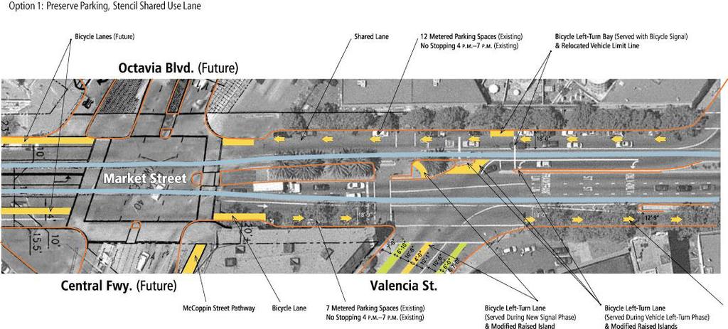
11 PROPOSED MITIGATION MEASURES Review traffic signal timing at the Market/Gough/Haight intersection to reduce westbound vehicle queuing across the Franklin/Page/12th intersection. W6. GOUGH TO OCTAVIA COST $100,000 For additional detail on the specific cost items associated with this segment, see page 19 of this Technical Memorandum RECOMMENDED BICYCLE FACILITY Install shared lane use arrows. Existing section, excluding F-Line track lane, consists of an 18-0 lane shared for travel and metered vehicle parking. Install bicycle left-turn lane (in advance of vehicle left-turn lane) from westbound Market Street onto Valencia Street. Install bicycle left-turn bay (against Market s northern curb) and bicycle traffic signal to serve bicycles traveling to Valencia Street. WORK REQUIRED FOR IMPLEMENTATION Delineate shared lane use arrows and install signage. For bicycle left-turn lane, remove portion of raised island west of proposed lane and portion of two-foot wide channelized vehicular island. Relocate limit line for westbound vehicles. For bicycle left-turn bay, delineate bay with striping and signage. Note that bay will not remove any existing parking as it would be adjacent to an abandoned curb cut. Install bicycle signal. BENEFITS Provides continuous bicycle facility. Facilitates bicycle left-turns to Valencia two different ways: via an exclusive bicycle left-turn lane served during the vehicular left-turn traffic signal phase; and with a left-turn storage bay served with a bicycle signal that overlaps with the pedestrian crossing signal for Market Street. NEGATIVE IMPACTS None. PROPOSED MITIGATION MEASURES None. Page 10 of 20
12 EASTBOUND SEGMENTS The following section of the report details each eastbound segment (by block) from west to east. The following is described for each block: Description of recommended bicycle facility Work required to implement recommended bicycle facility Benefits of recommended bicycle facility Negative impacts of recommended bicycle facility (to transit operations, vehicular circulation or other) Proposed mitigation measures for negative impacts associated with the recommended bicycle facility E1. CENTRAL FREEWAY TO GOUGH COST $3,200 For additional detail on the specific cost items associated with this segment, see page 19 of this Technical Memorandum RECOMMENDED BICYCLE FACILITY Install shared lane use arrows. Existing section, excluding F-Line track lane, is between 18-0 and 18-9, except near the MUNI boarding island and curb where the section is 12-0 wide. To facilitate bicycle left-turns from northbound Valencia Street onto westbound Market Street, install actuated bicycle left-turn lane. WORK REQUIRED FOR IMPLEMENTATION Delineate shared lane use arrows and install signage. For bicycle left-turn lane from Valencia Street, remove portion of raised island between crosswalk refuge and palm tree. Bicycle left-turn should be at least 5-0 wide with raised channelization to the west of the island. Assuming a two-foot wide island, a total of three feet would need to be removed from the remaining lanes (e.g., reduce Valencia s bicycle lanes to five feet each and the southbound vehicle travel lane from 10-8 to 10-6 ). Install actuated bicycle signal. BENEFITS Provides continuous bicycle facility. Facilitates bicycle left-turns from northbound Valencia Street onto westbound Market Street. NEGATIVE IMPACTS Bicycle left-turn signal would require new signal phase at Market/Valencia intersection. Depending upon future signal operations at Market/Octavia/Central Freeway, the bicycle phase may or may not affect traffic operations. PROPOSED MITIGATION MEASURES Mitigation measures may be required to accommodate the proposed bicycle left-turn signal, depending upon the results of further technical analysis conducted as a part of the Octavia Boulevard and Central Freeway projects. Page 11 of 20
13 E2. GOUGH TO 12TH COST $1,800 For additional detail on the specific cost items associated with this segment, see page 19 of this Technical Memorandum RECOMMENDED BICYCLE FACILITY Install shared lane use arrows. Existing section, excluding F-Line track lane, is between 18-9 and WORK REQUIRED FOR IMPLEMENTATION Delineate shared lane use arrows and install signage. BENEFITS Provides continuous bicycle facility. NEGATIVE IMPACTS None. PROPOSED MITIGATION MEASURES None. E3. 12TH TO 11 TH COST $1,900 For additional detail on the specific cost items associated with this segment, see page 19 of this Technical Memorandum RECOMMENDED BICYCLE FACILITY Between 12 th and Van Ness, retain existing bicycle lane. Existing section between MUNI boarding island and curb consists of a 11-9 travel lane and a 6-0 bicycle lane. Between Van Ness and 11 th, install bicycle lane with buffer. Existing section, excluding F-Line track lane, consists of an 11-0 inside travel lane and a 12-0 outside travel lane. WORK REQUIRED FOR IMPLEMENTATION Remove outside travel lane between South Van Ness and 11th, stripe bicycle lane and install signage. BENEFITS Provides exclusive bicycle facility. NEGATIVE IMPACTS Removes outside travel lane between South Van Ness and 11 th. There are currently two travel lanes between South Van Ness and 10 th and bicycle lane installation would require removing the outside travel lane. There is Page 12 of 20
14 one upstream travel lane (west of South Van Ness) and the two through travel lanes east of South Van Ness transition to a through lane and a right-turn lane at 10 th. Current eastbound weekday p.m. peak hour traffic volumes on this segment are about 770 vehicles per hour, with 200 of these vehicles turning right onto 10 th. Upon travel lane reduction, the eastbound approach s queuing capacity would decrease from 1,020 to 620 feet. Based on a queuing probability analysis, during the peak hour less than 10 percent of the vehicular queues would exceed 620 feet. PROPOSED MITIGATION MEASURES Review traffic signal timing at the Market/10th intersection to reduce eastbound vehicle queuing approaching the South Van Ness intersection. E4. 11TH TO 10TH COST $2,300 For additional detail on the specific cost items associated with this segment, see page 19 of this Technical Memorandum RECOMMENDED BICYCLE FACILITY Install bicycle lane with buffer, transitioning across existing right-turn lane into a shared bicycle/vehicle lane. Existing section, excluding F-Line track lane, consists of a 10-6 inside travel lane and a 12-0 right-turn lane. WORK REQUIRED FOR IMPLEMENTATION Remove portion of outside travel lane, retaining right-turn lane, stripe bicycle lane, shared lane use arrows, and install signage. BENEFITS Provides continuous bicycle facility. Provides delineated bicycle zone through vehicular right-turn lane. NEGATIVE IMPACTS Removes portion of outside travel lane. See 12 th to 11 th discussion above. PROPOSED MITIGATION MEASURES See 12 th to 11 th discussion above. E5. 10TH TO 9 TH COST $3,100 For additional detail on the specific cost items associated with this segment, see page 19 of this Technical Memorandum Page 13 of 20
15 RECOMMENDED BICYCLE FACILITY Install bicycle lane and buffer west of MUNI boarding island. Existing section, excluding F-Line track lane, consists of a 22-0 travel lane. Install bicycle lane on east side of block. Existing section between boarding island and curb consists of a 16-6 travel lane. WORK REQUIRED FOR IMPLEMENTATION Stripe bicycle lane and install signage. BENEFITS Provides exclusive bicycle facility. NEGATIVE IMPACTS None. PROPOSED MITIGATION MEASURES None. E6. 9TH TO 8TH COST $4,600 For additional detail on the specific cost items associated with this segment, see page 19 of this Technical Memorandum RECOMMENDED BICYCLE FACILITY Install bicycle lane with buffer, transitioning across existing right-turn lane into a shared bicycle/vehicle lane. Existing section, excluding F-Line track lane, consists of a 22-0 travel lane (with the curb often used for permitted loading and unloading) on the west side of the block and a 10-0 inside travel lane and a 11-6 right-turn lane on the east side of the block. A MUNI boarding island is located adjacent to the 10-0 travel lane. WORK REQUIRED FOR IMPLEMENTATION Stripe bicycle lane, shared lane use arrows, and install signage. BENEFITS Provides continuous bicycle facility. Provides delineated bicycle zone through vehicular right-turn lane. NEGATIVE IMPACTS Displaces loading/unloading zone adjacent to curb. This space is currently used by taxis, shuttle buses, and other vehicles for loading and unloading patrons in front of the Ramada Inn. Removes portion of outside travel lane. This improvement, however, would not reduce the travel lane s capacity. PROPOSED MITIGATION MEASURES Page 14 of 20

16 A new loading and unloading zone could be created in this segment by widening the curb by approximately three feet. Such widening would enable a 12-0 travel lane, a 6-0 bicycle lane, and a 7-0 loading/unloading zone. Additional detail is provided below under the next two bullet points. Additional Detail: The existing sidewalk at this location has a total width from building façade to outside curb face of The existing tree well grates and surrounding brickwork are located 5-6 from the existing curb. Midblock, this zone between the existing curb and tree row is not frequently used by pedestrian and is frequently used by delivery trucks illegally mounting the curb and parking over on the sidewalk. The de facto pedestrian realm is between the building facades and the tree row, a 20-0 zone. Approximately 4-0 can be gained by moving the curb adjacent to the existing brick edging surrounding the tree well grate, shown in the photo below. Additional Detail: There are few utilities located between 9 th and 8 th on the eastbound side, and drainage appears straightforward, providing for a low-cost curb moving project. The following sections illustrate this concept: Page 15 of 20

17 This same concept could be implemented on west bound Market Street between 8 th and 9th and on both sides of the street between 9 th and 10 th. PLANNING-LEVEL COST ESTIMATE The planning level cost estimate on page 19 presents the costs associated with the short and medium term improvements outline above and presented in the graphic presentation of the recommended design. Due to the minimal civil engineering work and limited physical modifications to Market Street proposed, the costs are predominantly associated with re-striping, new striping and stenciling, and intersection signal phase studies and engineering. The estimated cost associated with the recommendations presented in this paper is approximately $225,000. This figure does not include the optional costs associated with new parking bays that would require extensive curb moving, sidewalk reconstruction, re-striping and new signage. The costs associated with optional parking bays are Page 16 of 20
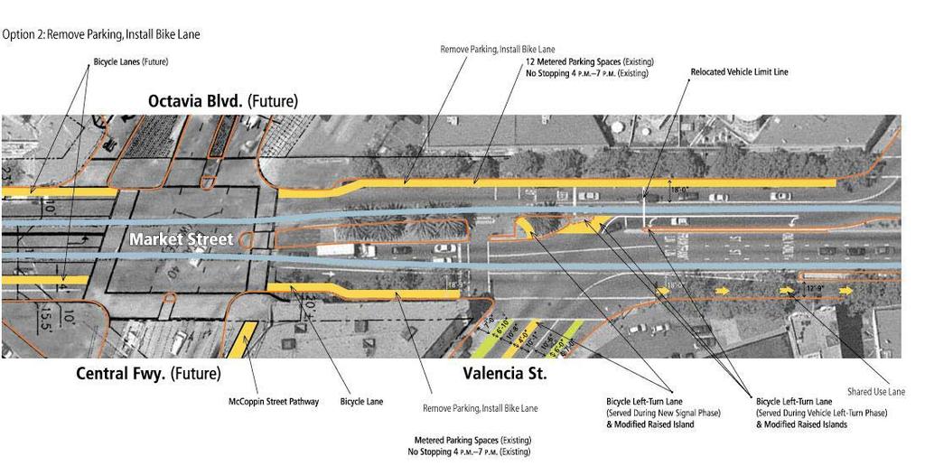
18 approximately $450,000 per 300 lineal feet of curb moving, utility reconstruction, and sidewalk reconstruction. This option, depending on the number of blocks addressed, would substantially add to the project cost. Unit costs for the planning level cost estimate come from a variety of public agency sources in the Bay Area, with most of the figures derived directly from recent project estimates and documentation completed by the San Francisco Department of Parking and Traffic and San Francisco Department of Public Works. Other agency data used comes from Alameda County and Contra Costa County. LONGER-TERM IMPROVEMENTS Assuming that bicycle volumes will continue to increase and that mode-share split for bicycles continues to increase in San Francisco, it may be ultimately desirable to further formalize bicycle traffic on Market Street. If Market Street bicycle mode-share increases are accompanied by a decrease in one or more other modes of transportation, specifically private automobile traffic on Market Street, then implementation of a continuous bicycle lane may have minimal impacts. The continuous bicycle lane is desirable to accommodate larger platoons of bicyclists and to prioritize movement of large numbers of bicyclists through the complex intersections along Market Street. In order for a continuous bicycle lane to function effectively in prioritizing bicycle movement through intersections, other signal and intersection modification would be necessary as well. Generally speaking, the primary difference between the proposal set forth in this Technical Memorandum and this longer-term concept, is additional parking removal. Removal of the following parking spaces would be required to do this: Westbound: 12 spaces between Gough and Octavia; Westbound: 7 spaces between Central Freeway and Valencia, 8 spaces between Gough and Brady, and 15 spaces (including 6 for motorcycles) between Brady and 12 th. Some of this parking loss could be offset by conversion of 12 th Street to angled parking and other local parking configuration changes to maximize usage of available curb space and right-of-way. Page 17 of 20
19 This page intentionally left blank Page 18 of 20

20 Market Street Study: Bicycle Solutions for Octavia to 8th Remove Lane Marking Install Lane Stripe Install Bike Lane Install Bike Lane/Buffer Signing Pavement Markers Shared Lane Arrows Island Reconstruction Bicycle Signal Curb Relocation Paving $1.90/LF $1.90/LF $1.90/LF $10/LF $300/Sign $6.50/Marker $150/Arrow $500/SF $10,000/Intersection $1500/LF $3/SF SEGMENT Segment LF Cost LF Cost LF Cost LF Cost No. Cost No. Cost No. Cost EA Cost No. Cost LF Cost SF Cost SUBTOTALS Westbound Market Hyde to Larkin 30 $ $ 2, $ 2, $ $ $ 10, $ $16,958 Larkin to Polk 380 $ $ $ 3, $ $ $5,864 Polk to Van Ness 320 $ $ $ 2, $ $ $4,017 Van Ness to Franklin 600 $ 1, $ $ 3, $ $4,968 Franklin to Gough 60 $ $ $ $ 1, $ $ $ $3,452 Gough to Octavia 60 $ $ 1, $ 1, $ 30, $ 10, $ 60, $ $103,264 Eastbound Market Central Freeway to Gough 40 $ $ 2, $ 1, $3,226 Gough to 12th 12 $ 1, $1,800 12th to 11th 100 $ $ 1, $ $ $ $1,947 11th to 10th 180 $ $ $ $ $ $2,274 10th to 9th 380 $ $ 1, $ $3,122 9th to 8th 300 $ $ 3, $ $ $4,553 OPTIONAL ITEM: 9th to 8th Parking Bay (Cost not included in total) 300 $ $ $ 1, $ 450, $452,940 Unit Subtotals $ 1, $ 6, $ 19, $ 6, $ $ 6, $ 30, $ 20, $ 60, $ 1, Design Cost (15% Project Cost) $23,316 Project Contingency Cost (25% Project Cost) $38,861 Traffic Management Cost (5% Project Cost) $7,772 $155,442 PROJECT COST $ 225,391 Unit Costs 4" White or Yellow Remove $ 1.90 LF 4" Solid White Install $ 1.90 LF 6" Solid White Install (Bike Lanes) $ 1.90 LF Install 2 Stripe Buffer (Two 8" lines with hatch) $ LF Pavement Markers $ 6.50 PER Install Shared Use Arrow: $ PER Curb Relocation (Market Street 6"x12" Granite) $ 1, PER Sign (standard size, existing pole mount): $ PER Island Reconstruction $ SF Bicycle Signal $ 10, PER INTERSECTION Loop Detector $ 1, PER Asphalt Paving $ 3.00 SF Sidewalk Reconstruction $ 6.00 SF Drainage Utilities $ 10, PER NOTE ON UNIT COST SOURCES: Unit costs for the planning level cost estimate come from a variety of public agency sources in the Bay Area, with most figures derived directly from recent project estimates and documentation completed by the San Francisco Department of Parking and Traffic and San Francisco Department of Public Works. Other agency data used comes from Alameda County and Contra Costa County.
21 SEGMENT 1
22 SEGMENT 2
23 SEGMENT 3
24 SEGMENT 4
25 SEGMENT 5
26 SEGMENT 5 OPTION 2
27 SEGMENT 6
28 SEGMENT 6
APPENDIX A: Complete Streets Checklist DRAFT NOVEMBER 2016
 APPENDIX A: Complete Streets Checklist DRAFT NOVEMBER 2016 Complete Streets Checklist MetroPlan Orlando s Complete Streets Checklist is an internal planning tool for staff to further implementation of
Active Transportation Facility Glossary
 Active Transportation Facility Glossary This document defines different active transportation facilities and suggests appropriate corridor types. Click on a facility type to jump to its definition. Bike
CURBSIDE ACTIVITY DESIGN
 5 CURBSIDE ACTIVITY DESIGN This chapter provides design guidance for separated bike lanes adjacent to curbside activities including parking, loading and bus stops. Typical configurations are presented
Cycle Track Design Best Practices Cycle Track Sections
 Design Best Practices Sections It is along street segments where the separation and protection methods of cycle tracks offer more comfort than conventional bicycle lanes, and are more attractive to a wide
CITY OF OTTAWA ROADWAY MODIFICATION APPROVAL UNDER DELEGATED AUTHORITY
 RMA-2015-ATM-038 CITY OF OTTAWA ROADWAY MODIFICATION APPROVAL UNDER DELEGATED AUTHORITY DATE: April 22, 2015 SUBJECT Approval of Roadway Modifications Recommended through an Area Traffic Management Study
Station 1: Street & Sidewalk Upgrades
 Station 1: Street & Sidewalk Upgrades Existing no left turn; Potential left turn arrow, see Circulation Study boards for more information Thru-lane guidance Improved lead-in green bike lane 17TH ST CASTRO
NJDOT Complete Streets Checklist
 Background The New Jersey Department of Transportation s Complete Streets Policy promotes a comprehensive, integrated, connected multi-modal network by providing connections to bicycling and walking trip
Appendix C. TRAFFIC CALMING PROGRAM TOOLBOX
 Appendix C. TRAFFIC CALMING PROGRAM TOOLBOX PHASE I...2 Do Not Enter Sign...3 One-Way Sign...4 Turn Prohibition...5 Pavement Markings...6 Speed Monitoring Trailer...7 Neighborhood Speed Watch...8 Police
REGIONAL BICYCLE AND PEDESTRIAN DESIGN GUIDELINES
 REGIONAL BICYCLE AND PEDESTRIAN DESIGN GUIDELINES November 16, 2011 Deb Humphreys North Central Texas Council of Governments Bicycle and Pedestrian Advisory Committee Snapshot of the Guide 1. Introduction
Off-road Trails. Guidance
 Off-road Trails Off-road trails are shared use paths located on an independent alignment that provide two-way travel for people walking, bicycling, and other non-motorized users. Trails specifically along
Central Freeway and Octavia Circulation Study
 Central Freeway and Octavia Circulation Study Final Report Plans and Programs Committee San Francisco County Transportation Authority September 18, 2012 Presentation Outline Background and Study Purpose
Broad Street Bicycle Boulevard Design Guidelines
 Broad Street Bicycle Boulevard Design Guidelines Building from the strategies introduced in the 2013 Bicycle Transportation Plan and community input received thus far, City Transportation Staff have identified
Coquitlam Cross-town Bike Route Improving Bicycle Facilities in a Mature Suburban Environment
 Coquitlam Cross-town Bike Route Improving Bicycle Facilities in a Mature Suburban Environment Sarah Rocchi, Vice-President, Projects, Opus International Consultants (Main Presenter) Catherine Mohoruk,
A Survey of Planning, Design, and Education for Bikeways and Bus Routes on Urban Streets
 A Survey of Planning, Design, and Education for Bikeways and Bus Routes on Urban Streets, Community & Economic Development Agency, Transportation Services Division (510) 238-3983 bikeped@oaklandnet.com
Project Goal and Description. Why Broadway? Broadway SFMTA.COM/BROADWAY. The goal of the Broadway Safety Improvement
 PROJECT OVERVIEW Project Goal and Description The goal of the Broadway Safety Improvement d St Van Ness Ave Project is to improve safety and comfort for all who Franklin St Hyde St Octavia St Gough St
Clybourn Ave. Protected Bike Lane Study Halsted St. to Division St.
 Clybourn Ave. Protected Bike Lane Study Halsted St. to Division St. Nathan Roseberry, Senior Engineer Pam Broviak, Project Manager July 24, 2014 Agenda Project Goals Existing Roadway Conditions Traffic
Chapter 2: Standards for Access, Non-Motorized, and Transit
 Standards for Access, Non-Motorized, and Transit Chapter 2: Standards for Access, Non-Motorized, and Transit The Washtenaw County Access Management Plan was developed based on the analysis of existing
SAN FRANCISCO MUNICIPAL TRANSPORTATION AGENCY
 THIS PRINT COVERS CALENDAR ITEM NO. : 12 DIVISION: Sustainable Streets BRIEF DESCRIPTION: SAN FRANCISCO MUNICIPAL TRANSPORTATION AGENCY Approving various bicycle improvements and traffic modifications
2.0 LANE WIDTHS GUIDELINE
 2.0 LANE WIDTHS GUIDELINE Road Engineering Design Guidelines Version 2.0.1 May 2018 City of Toronto, Transportation Services City of Toronto Page 0 Background In early 2014, Transportation Services initiated
Corpus Christi Metropolitan Transportation Plan Fiscal Year Introduction:
 Introduction: The Safe, Accountable, Flexible, Efficient Transportation Equity Act: A Legacy for Users (SAFETEA-LU) has continued the efforts started through the Intermodal Surface Transportation Efficiency
C C C
 C-012-001 Thank you for your support for the creation of new public space and nonmotorized access between downtown and the waterfront through the Overlook Walk, the East-West Connections, and the Promenade.
MARKET STREET STUDY TECHNICAL REPORT PEDESTRIAN CIRCULATION
 MARKET STREET STUDY TECHNICAL REPORT PEDESTRIAN CIRCULATION This technical report is one of over a dozen reports prepared to support the Market Street Study. The purpose of the technical reports was to
Agenda. Overview PRINCE GEORGE S PLAZA METRO AREA PEDESTRIAN PLAN
 PRINCE GEORGE S PLAZA METRO AREA PEDESTRIAN PLAN May 28, 2008 Agenda Welcome and introductions Project overview and issue identification Planning context and strengths Design challenges and initial recommendations
SAN FRANCISCO MUNICIPAL TRANSPORTATION AGENCY
 THIS PRINT COVERS CALENDAR ITEM NO: 10.2 DIVISION: Sustainable Streets BRIEF DESCRIPTION: SAN FRANCISCO MUNICIPAL TRANSPORTATION AGENCY Approving various routine parking and traffic modifications. SUMMARY:
Better Market Street. Engineering, Maintenance & Safety Committee (EMSC) February 28, 2018
 February 28, 2018") Better Market Street Engineering, Maintenance & Safety Committee (EMSC) February 28, 2018 1 Market Street Market Street - San Francisco by rulenumberone2 2 Market Street is the... City s busiest pedestrian
Better Market Street Engineering, Maintenance & Safety Committee (EMSC) February 28, 2018 1 Market Street Market Street - San Francisco by rulenumberone2 2 Market Street is the... City s busiest pedestrian
Draft North Industrial Area-Wide Traffic Plan
 Summary of North Industrial and Hudson Bay Industrial Recommended Improvements Table 1. Summary of s Item Location 1 2 3 4 5 6 7 8 9 10 11 12 Millar Ave north of 51st St Super 8 Motel back lane 400 Block
Upper Market Street Bike Lane Project
 Upper Market Street Bike Lane Project 17th Street to Octavia Boulevard 6 30 2010 SAN FRANCISCO, CALIFORNIA Agenda San Francisco & Sustainable Transportation Project Goals Outreach & Coordination Project
5. RUNNINGWAY GUIDELINES
 5. RUNNINGWAY GUIDELINES These guidelines should be considered collectively when making runningway decisions. A runningway is the linear component of the transit system that forms the right-of-way reserved
102 Avenue Corridor Review
 February 26, 2015 102 Avenue Corridor Review Transportation Association of Canada Road Safety Engineering Award Submission for the City of Edmonton Introduction Transportation Association of Canada Road
Appendix T CCMP TRAIL TRAFFIC & TRANSPORTATION DESIGN STANDARD
 Appendix T CCMP 3.3.4 TRAIL TRAFFIC & TRANSPORTATION DESIGN STANDARD 3.3.4 Trail Traffic and Transportation Design Multi-use trails have certain design standards, which vary depending on the agency that
Memorandum. Sunday, July 13, Saturday, July 19, 2014
 Memorandum To: David Lowin, Brooklyn Bridge Park Corporation From: Daniel Schack, AICP, PTP Date: Re: Brooklyn Bridge Park Pier 5/6 Loop Road Traffic Study Project No: 14-01-2407 At the request of Brooklyn
On Road Bikeways Part 1: Bicycle Lane Design
 On Road Bikeways Part 1: Bicycle Lane Design Presentation by: Nick Jackson Bill Schultheiss, P.E. September 04, 2012 FOLLOW THE CONVERSATION ON TWITTER Toole Design Group is live tweeting this webinar
SAN FRANCISCO MUNICIPAL TRANSPORTATION AGENCY
 THIS PRINT COVERS CALENDAR ITEM NO. : 10.2 DIVISION: Sustainable Streets BRIEF DESCRIPTION: SAN FRANCISCO MUNICIPAL TRANSPORTATION AGENCY Adopting Conceptual Proposal for Streetscape Improvements to Broadway,
Guidance. ATTACHMENT F: Draft Additional Pages for Bicycle Facility Design Toolkit Separated Bike Lanes: Two-Way to One-Way Transitions
 ATTACHMENT F: Draft Additional Pages for Bicycle Facility Design Toolkit Separated Bike Lanes: Two-Way to One-Way Transitions This treatment provides a transition from two-way separated bike lanes to one-way
Complete Street Analysis of a Road Diet: Orange Grove Boulevard, Pasadena, CA
 Complete Street Analysis of a Road Diet: Orange Grove Boulevard, Pasadena, CA Aaron Elias, Bill Cisco Abstract As part of evaluating the feasibility of a road diet on Orange Grove Boulevard in Pasadena,
Item No. 14 Town of Atherton
 Item No. 14 Town of Atherton CITY COUNCIL STAFF REPORT CONSENT AGENDA TO: THROUGH: FROM: HONORABLE MAYOR AND CITY COUNCIL GEORGE RODERICKS, CITY MANAGER MICHAEL KASHIWAGI, COMMUNITY SERVICES DIRECTOR MARTY
EUCLID AVENUE PARKING STUDY CITY OF SYRACUSE, ONONDAGA COUNTY, NEW YORK
 EUCLID AVENUE PARKING STUDY CITY OF SYRACUSE, ONONDAGA COUNTY, NEW YORK CITY OF SYRACUSE DEPARTMENT OF PUBLIC WORKS 1200 CANAL STREET EXTENSION SYRACUSE, NEW YORK 13210 DRAFT REPORT DATE: November 13,
SAN FRANCISCO MUNICIPAL TRANSPORTATION AGENCY
 THIS PRINT COVERS CALENDAR ITEM NO. : SAN FRANCISCO MUNICIPAL TRANSPORTATION AGENCY DIVISION: Sustainable Streets Transportation Engineering BRIEF DESCRIPTION: Requesting that the San Francisco Municipal
Addendum to Mitigated Negative Declaration
 Addendum Date: Case No.: 2014.1499E Project Title: (MDSP) - Mission Valencia Green Gateway Streetscape Project Original: 2008.1075, MDSP Mitigated Negative Declaration Project Sponsor: Charlie Ream, San
Public Information Centre
 WELCOME Public Information Centre Father Tobin Road Lougheed Middle School - Library Wednesday November 7, 2012 7:00 p.m.to 9:00 p.m. Please sign in Neighbourhood Traffic Calming Guide Background The City
Simulation Analysis of Intersection Treatments for Cycle Tracks
 Abstract Simulation Analysis of Intersection Treatments for Cycle Tracks The increased use of cycle tracks also known as protected bike lanes has led to investigations of how to accommodate them at intersections.
Appendix 3 Roadway and Bike/Ped Design Standards
 Appendix 3 Roadway and Bike/Ped Design Standards OTO Transportation Plan 2040 4/20/2017 Page A3-1 Adopted Standards The adopted OTO Design Standards and Major Thoroughfare Plan are contained herein.
SAN FRANCISCO MUNICIPAL TRANSPORTATION AGENCY
 THIS PRINT COVERS CALENDAR ITEM NO. : 11 DIVISION: Sustainable Streets BRIEF DESCRIPTION: SAN FRANCISCO MUNICIPAL TRANSPORTATION AGENCY Approving traffic modifications on Twin Peaks Boulevard between Christmas
12/4/2016 VIA . RE: Grocery Outlet Del Paso (DR16-328)
") 12/4/2016 VIA EMAIL Ethan Meltzer, Assistant Planner City of Sacramento Community Development Department 300 Richards Blvd, 3 rd Floor Sacramento, CA 95811 RE: Grocery Outlet Del Paso (DR16-328) Dear Mr.
12/4/2016 VIA EMAIL Ethan Meltzer, Assistant Planner City of Sacramento Community Development Department 300 Richards Blvd, 3 rd Floor Sacramento, CA 95811 RE: Grocery Outlet Del Paso (DR16-328) Dear Mr.
Mission-Geneva Transportation Study Community Workshop 2 July 8, 2006
 Community Workshop 2 July 8, 2006 Small Group Workbook 1 Basic Improvements on Mission Street Streetscape. Pedestrian-scale lighting; landscaping; community art on utility boxes; more (possibly unique)
Protected Bike Lanes in San Francisco Mike Sallaberry SFMTA NACTO Workshop - Chicago IL
 Protected Bike Lanes in San Francisco Mike Sallaberry SFMTA 10 14 2011 NACTO Workshop - Chicago IL San Francisco 2 nd Highest Density in the U.S. 47 square miles Mild Climate Market Population ~810,000
Roadways. Roadways III.
 Introduction 97 Roadway Design Principles 98 Safe Speeds 99 Optimizing of Street Space 00 Minimum Lane Widths in the City of Boston 02 Design Features that Reduce Operating Speeds 05 Travel Lanes Transit
Omaha s Complete Streets Policy
 Omaha s Complete Streets Policy (Adopted August 2015) VISION To create great places and enhance our quality of life, the City of Omaha will provide safe, accessible streets for all users. Complete Streets
5/31/2016 VIA . Arwen Wacht City of Sacramento Community Development Department 300 Richards Blvd., 3 rd Floor Sacramento, CA 95811
 5/31/2016 VIA EMAIL Arwen Wacht City of Sacramento Community Development Department 300 Richards Blvd., 3 rd Floor Sacramento, CA 95811 RE: El Pollo Loco (P16-028) Dear Ms. Wacht: WALKSacramento has reviewed
PRINCE GEORGE S PLAZA METRO AREA PEDESTRIAN PLAN
 PRINCE GEORGE S PLAZA METRO AREA PEDESTRIAN PLAN May 28, 2008 Agenda Welcome and introductions Project overview and issue identification Planning context and strengths Design challenges and initial recommendations
Multi-Modal Traffic Analysis. Parisi and Associates
 Mill Valley to Corte Madera Bicycle and Pedestrian Corridor Study Appendix D: Multi-Modal Traffic Analysis Prepared by Parisi and Associates August 2009 Appendix D - Multi-Modal Traffic Analysis Table
BD RESOLUTION NO RESOLUTION ADOPTING THE VISION ZERO RAMP INTERSECTION STUDY PHASE 1
 BD00 RESOLUTION NO. - RESOLUTION ADOPTING THE VISION ZERO RAMP INTERSECTION STUDY PHASE [NTIP PLANNING] FINAL REPORT WHEREAS, The Vision Zero Ramp Intersection Study Phase was recommended by Commissioner
Bicycle Facilities Planning
 Bicycle Facilities Planning Overview Types of Cyclists Purpose for Riding Types of Facilities Bike Lanes Bicycle Boulevards Cycle Tracks Intersections Signals Signing and Marking Discussion Types of Bicyclists
Exhibit 1 PLANNING COMMISSION AGENDA ITEM
 Exhibit 1 PLANNING COMMISSION AGENDA ITEM Project Name: Grand Junction Circulation Plan Grand Junction Complete Streets Policy Applicant: City of Grand Junction Representative: David Thornton Address:
SAN FRANCISCO MUNICIPAL TRANSPORTATION AGENCY
 THIS PRINT COVERS CALENDAR ITEM NO.: 10.3 DIVISION: Sustainable Streets BRIEF DESCRIPTION: SAN FRANCISCO MUNICIPAL TRANSPORTATION AGENCY Approving various traffic and parking modifications on Bay Street
Outreach Approach RENEW SF served as the primary liaison with the North Beach community; the Chinatown. Executive Summary
 Executive Summary Executive Summary The Columbus Avenue Neighborhood Transportation Study s objective is to identify changes to transportation infrastructure and policies that could enhance the livability
Complete Streets. Designing Streets for Everyone. Sarnia
 Complete Streets Designing Streets for Everyone Sarnia Complete Streets ~ Sarnia ~ 2018 Introduction Our City is made up of a network of streets that we use to go for a walk, cycle to work, drive to the
Los Altos Hills Town Council - June 18, 2015 Palo Alto City Council June 22, AGENDA ITEM #2.B Presentation
 Los Altos Hills Town Council - June 18, 2015 Palo Alto City Council June 22, 2015 AGENDA ITEM #2.B Presentation Previous Presentations Los Altos Hills Town Council in May 2014 and February 2015 Palo Alto
Duwamish Way-finding and CTR Report
 V. North Tukwila When the North Tukwila Manufacturing and Industrial Center was designated in 1992 as part of the region s land use and transportation plan, the plan called for the area to set a light-rail
NM-POLICY 1: Improve service levels, participation, and options for non-motorized transportation modes throughout the County.
 Transportation PRINCE WILLIAM COUNTY 2008 COMPREHENSIVE PLAN NON-MOTORIZED PLAN CONTENTS Goals, Policies, and Action Strategies Table 4 (Bike Facility Classifications and Descriptions) Table 5 (Bike Facility
CITY OF LOS ANGELES INTER-DEPARTMENTAL MEMORANDUM
 CITY OF LOS ANGELES INTER-DEPARTMENTAL MEMORANDUM Date: April 1, 219 To: Honorable City Council c/o City Clerk, Room 395, City Hall Attention: Honorable Mike Bonin, Chair, Transportation Committee From:
San Francisco County Transportation Authority Proposition K Sales Tax Program Allocation Request Form
 FY of Allocation Action: 2006/07 Project Name: Implementing Agency: Market Street Bike Lane, Octavia Boulevard to 17th Street Department of Parking and Traffic Category: Subcategory: EXPENDITURE PLAN INFORMATION
Caltrans Sloat Boulevard Pedestrian Safety Project Response to Community Questions, Comments & Concerns
 Caltrans Sloat Boulevard Pedestrian Safety Project Response to Community Questions, Comments & Concerns Revised: May 10, 2016 The California Department of Transportation (Caltrans) is planning various
C/CAG. Sunnybrae Elementary School Walking and Bicycling Audit. San Mateo-Foster City School District JUNE 2013
 Sunnybrae Elementary School Walking and Bicycling Audit JUNE 2013 San Mateo-Foster City School District C/CAG City/County Association of Governments of San Mateo County SUNNYBRAE ELEMENTARY SCHOOL WALKING
Broad Street Bicycle Boulevard City Council Study Session Summary
 Broad Street Bicycle Boulevard City Council Study Session Summary Overview: On August 15 th, 2017, a City Council Study Session was held to invite community input and request City Council guidance on a
Appendix A: Crosswalk Policy
 Appendix A: Crosswalk Policy Appendix A: Crosswalk Policy Introduction This citywide Crosswalk Policy is aimed at improving pedestrian safety and enhancing pedestrian mobility by providing a framework
Data Analysis February to March Identified safety needs from reported collisions and existing travel patterns.
 Welcome! Thank you for participating in today s Valencia Bikeway Improvements workshop. Data Analysis February to March Identified safety needs from reported collisions and existing travel patterns. Initial
Solana Beach Comprehensive Active Transportation Strategy (CATS)
") Solana Beach Comprehensive Active Transportation Strategy (CATS) 3.0 Goals & Policies The Solana Beach CATS goals and objectives outlined below were largely drawn from the Solana Beach Circulation Element
Solana Beach Comprehensive Active Transportation Strategy (CATS) 3.0 Goals & Policies The Solana Beach CATS goals and objectives outlined below were largely drawn from the Solana Beach Circulation Element
Richmond-Adelaide Cycle Tracks
 Public Drop-In Event Richmond-Adelaide Cycle Tracks June 25, 2018 12:00 p.m. 3:00 p.m. 4:30 p.m. 7:30 p.m. Metro Hall, Rotunda 55 John Street 1 Purpose of Event In Scope Communicate an update about the
10.0 CURB EXTENSIONS GUIDELINE
 10.0 CURB EXTENSIONS GUIDELINE Road Engineering Design Guidelines Version 1.0 March 2017 City of Toronto, Transportation Services City of Toronto Page 0 Background In early 2014, Transportation Services
Lessons Learned from Cycle Tracks (Class IV Bikeways) Design Practice
 Design Practice") Lessons Learned from Cycle Tracks (Class IV Bikeways) Design Practice By: Min Zhou, P.E., Principal/Vice President KOA Corporation 1 What is a Cycle Track (Class IV) TYPICAL BIKEWAY CLASSIFICATION CLASS
Lessons Learned from Cycle Tracks (Class IV Bikeways) Design Practice By: Min Zhou, P.E., Principal/Vice President KOA Corporation 1 What is a Cycle Track (Class IV) TYPICAL BIKEWAY CLASSIFICATION CLASS
San Jose Transportation Policy
 San Jose Transportation Policy Protected Intersections in LOS Policies to Support Smart Growth Presented by: Manuel Pineda City of San Jose Department of Transportation Bay Area Map San Francisco Oakland
Welcome! San Jose Avenue Open House August 25, 2015
 Welcome! San Jose Avenue Open House August 25, 2015 Vision Zero The City and County of San Francisco adopted Vision Zero San Francisco Vision Zero High Injury Network as a policy in 2014, committing an
4. ENVIRONMENTAL IMPACT ANALYSIS 9. TRANSPORTATION AND TRAFFIC
 4. ENVIRONMENTAL IMPACT ANALYSIS 9. TRANSPORTATION AND TRAFFIC 4.9.1 INTRODUCTION The following section addresses the Proposed Project s impact on transportation and traffic based on the Traffic Study
Non-Motorized Transportation 7-1
 Non-Motorized Transportation 7-1 Transportation facilities no longer mean just accommodating a vehicle powered by a combustion engine. Pedestrian and non-motorized facilities are important modes of travel
Bicycle Boulevards and Neighborhood Greenways
 Bicycle Boulevards and Neighborhood Greenways Traffic Safety is Improving for Everyone 90 80 70 60 50 40 30 20 10 0 PORTLAND: TOTAL TRAFFIC FATALITIES 1986-2008 1986 1987 1988 1989 1990 1991 1992 1993
Environment and Public Works Committee Presentation
 Mixed Use Centers Complete Streets Guidelines Project Environment and Public Works Committee Presentation December 10, 2008 Project Objectives: Conduct an inter-departmental and agency process to study
INTERSECTION DESIGN TREATMENTS
 Designing for Bicyclist Safety INTERSECTION DESIGN TREATMENTS LEARNING OUTCOMES Understand intersection design options and features Select appropriate design feature for a bikeway in a given context C1
Implementing Complete Streets in Ottawa. Project Delivery Process and Tools Complete Streets Forum 2015 October 1, 2015
 Implementing Complete Streets in Ottawa October 1, 2015 The Essentials Complete Streets Implementation Framework will become part of the routine delivery of City transportation projects Approach uses every
Color your stress away
 Color your stress away Learn about the Bicycle Master Plan s comfortable, low-stress bicycling network in Montgomery County. Unwind as you color the bicycling scenes. Check out montgomeryplanning.org/bikeplan
6/22/2018 VIA . Darcy Goulart, Planning Manager City of Rancho Cordova Planning Department 2729 Prospect Park Drive Rancho Cordova, CA 95670
 6/22/2018 VIA EMAIL Darcy Goulart, Planning Manager City of Rancho Cordova Planning Department 2729 Prospect Park Drive Rancho Cordova, CA 95670 RE: Quick Quack Car Wash (DD9801) Dear Ms. Goulart: WALKSacramento
Blair/Williamson Intersection Expressed Needs
 Blair/Williamson Intersection Expressed Needs NORTH Blair Street is a barrier for pedestrians and bicycles Relocate Capitol City Trail crossing from Blair Street and John Nolen Drive intersection to Williamson
G AT E WAY PLAN. Community BRIEFING KIT GATEWAY BIKE
 G AT E WAY PLAN GATEWAY BIKE Community BRIEFING KIT PLAN August 2016 TABLE OF CONTENTS INTRODUCTION... 1 THE BENEFITS OF A BIKEABLE COMMUNITY... 2 ECONOMY...2 SAFETY...3 HEALTH...3 HOUSEHOLD SPENDING...3
Chapter 3 DESIGN SPECIFICATIONS
 Brampton PathWays Planning and Design Guidelines 27 Chapter 3 DESIGN SPECIFICATIONS 3.1 CLASS 1 MULTI-USE PATH Off-road multi-use trails are the backbone of the Brampton PathWays Network. They are typically
SAN FRANCISCO MUNICIPAL TRANSPORTATION AGENCY
 THIS PRINT COVERS CALENDAR ITEM NO. : 10.3 DIVISION: Sustainable Streets Division BRIEF DESCRIPTION: SAN FRANCISCO MUNICIPAL TRANSPORTATION AGENCY Approving traffic and parking modifications to install
East 12 th Street Bikeway Feasibility Study
 Final Report East 12 th Street Bikeway Feasibility Study Prepared for: City of Oakland Public Works Agency Submitted by: 180 Grand Avenue, Suite 250 Oakland, CA 94612 Phone: (510) 839-1742; Fax: (510)
SAN FRANCISCO MUNICIPAL TRANSPORTATION AGENCY
 THIS PRINT COVERS CALENDAR ITEM NO.: 10.2 DIVISION: Sustainable Streets BRIEF DESCRIPTION: SAN FRANCISCO MUNICIPAL TRANSPORTATION AGENCY Approving various routine parking and traffic modifications. SUMMARY:
Purpose: Financial Implications and Impact Statement: It is estimated that the cost to implement:
 Various Modifications Lower Jarvis Street and Lake Shore Boulevard East; Lower Jarvis Street, east side, between Lake Shore Boulevard East and The Esplanade - 45-77 Lower Jarvis Street; and Lower Jarvis
Forest Hills Improvement Initiative
 Forest Hills Improvement Initiative Transportation Action Plan Short Term Recommendations ONLY Final Draft as of April 30, 2008 For Community Review and Feedback Prepared for: The City of Boston Boston
David Hung, Associate Planner City of Sacramento Community Development Department 300 Richards Boulevard, 3 rd Floor Sacramento, CA
 June 13, 2016 VIA EMAIL David Hung, Associate Planner City of Sacramento Community Development Department 300 Richards Boulevard, 3 rd Floor Sacramento, CA 959811 RE: Fire Station 14 (DR16-128) Dear Mr.
MARTIN LUTHER KING JR. WAY
 OCTOBER 2011 40 Vision and Goals The Martin Luther King, Jr. Way Illustrative Master Plan that follows has been developed through a process of community involvement. It expresses a long term vision for
Polk Streetscape Project
 What is this project? The Polk Streetscape Project is an effort to improve safety for everyone traveling on Polk Street between Union and McAllister streets. Also included in this project are paving, sewer
Mission Bay Loop (MBL) Public Meeting
 Public Meeting") Mission Bay Loop (MBL) Public Meeting La Scuola Internazionale di San Francisco, November 18, 2014 Frequently Asked Questions 1. When would construction have to start before the SFMTA loses TIGER funds?
Mission Bay Loop (MBL) Public Meeting La Scuola Internazionale di San Francisco, November 18, 2014 Frequently Asked Questions 1. When would construction have to start before the SFMTA loses TIGER funds?
11/3/2014 VIA . WALKSacramento has reviewed the Stockton and T Mixed-Use project at 3675 T Street in the
 11/3/2014 VIA EMAIL Antonio Ablog Planning Department City of Sacramento 300 Richards Boulevard Sacramento, CA 95811 RE: Design Review for Stockton and T Mixed-Use (P14-042) Dear Mr. Ablog: WALKSacramento
HARRISON STREET/OAKLAND AVENUE COMMUNITY TRANSPORTATION PLAN
 HARRISON STREET/OAKLAND AVENUE Community Workshop #4: Draft Plan Review December 3, 2009 D E S I G N, C O M M U N I T Y & E N V I R O N M E N T INTRODUCTIONS Key Project Staff: Alisa Shen, Project Manager,
Northbound San Jose Avenue & I-280 Off-Ramp Road Diet Pilot Project
 Project Overview Fed by a two-lane Interstate-280 (I-280) off-ramp, high vehicular volumes and speeds are longstanding issues along San Jose Avenue. Residents in the surrounding neighborhoods have expressed
FEDERAL HIGHWAY ADMINISTRATION APPLICATION
 FEDERAL HIGHWAY ADMINISTRATION APPLICATION REQUEST FOR PERMISSION TO EXPERIMENT WITH A BICYCLE BOX INTERSECTION TREATMENT Submitted by: City of Columbus Department of Public Service Date: June 26, 2009
Access Management in the Vicinity of Intersections
 Access Management in the Vicinity of Intersections FHWA-SA-10-002 Technical Summary Photo: Ralph Bentley (used with permission) 0 Access Management is: The design, implementation and management of entry
FINAL REPORT DECEMBER 2011
 FINAL REPORT DECEMBER 2011 AKNOWLEDGEMENTS SFMTA Staff Erin Miller, Project Manager Timothy Papandreou Jerry Robbins Pamela Stone Mike Sallaberry Chris Dimeling Emily Drennen Suzanne Chen-Harding San
EXECUTIVE SUMMARY. Vision
 Vision Walking and bicycling in Salt Lake City will be safe, convenient, comfortable, and viable transportation options that connect people to places, foster recreational and economic development opportunities,