CITY OF SPRING HILL MAJOR THOROUGHFARE PLAN
|
|
|
- Richard McDowell
- 5 years ago
- Views:
Transcription


1 CITY OF SPRING HILL DRAFT STATEMENT OF QUALIFICATIONS FORM DT-0330, PART II JANUARY 2019 PREPARED BY VOLKERT, INC.

2 C H A P T E R 1. E X I S T I N G C O N D I T I O N S This chapter provides an overview of existing conditions within the City of Spring Hill study area. This information is the baseline data that enables City Staff, the Board of Mayor and Aldermen, the Planning Commission, City of Spring Hill Citizens, the development community, and other stakeholders to better understand the current function of the City s transportation system and to plan for its future growth. Existing land use, population, employment, and congestion levels have all been evaluated to assess opportunities for improvement to the transportation system for Spring Hill residents. The current transportation network will be analyzed to decide which future improvements can be recommended by determining those areas in need of improvement, deficient traffic conditions, or other inadequacies. S T U D Y A R E A City of Spring Hill, TN The study area for this Major Thoroughfare Plan includes the City Limits of Spring Hill, Tennessee. The City of Spring Hill is located in the southern portion of Williamson County and the northern portion of Maury County. Spring Hill is approximately 13 miles south of downtown Franklin and 12 miles north of downtown Columbia. A Study Area Map is shown as Figure 1.1 below. Spring Hill has an incorporated area of square miles inside the Spring Hill city limits. US Highway 31 (Columbia Pike/Main Street) is the primary north/south route within the City and State Route 396 (Saturn Parkway) is the primary east/west route into the city from I-65. The City also has a number of Arterial and Collector Streets, which are described in greater detail below, with the rest of the street network functioning as local access roads. EXISTING CONDITIONS REPORT 1
3 BUCKNER ROAD LEWISBURG PIKE CARTERS CREEK PIKE «247 «247 BEECHCROFT ROAD 31 MAIN STREET CAMPBELL STATION PARKWAY NEW PORT ROYAL ROAD DUPLEX ROAD PORT ROYAL ROAD BUCKNER LANE « WILLIAMSON COUNTY KEDRON ROAD LEWISBURG PIKE MAURY COUNTY MARSHALL COUNTY Legend Data Source: City of Spring Hill, TDOT Spring Hill Roads County Border Spring Hill City Limits Spring Hill Urban Growth Boundary Figure 1.1: Study Area - Spring Hill City Limits Spring Hill Major Thoroughfare Plan Hickman Lewis Dickson Maury Williamson Davidson Rutherford Bedford Wilson Marshall Lawrence Giles ± Miles Cannon Coffee

4 P O P U L A T I O N A N D E M P L O Y M E N T This section highlights current population and employment data obtained from the U.S. Census Bureau, Nashville Area MPO, and the City of Spring Hill. The base year for all population and employment data utilized for this Major Thoroughfare Plan is The year 2010 is used in order to more closely correlate any transportation improvements with the Nashville Area Metropolitan Planning Organization s Long Range Transportation Plan, which also utilizes 2010 as the base year for Campbell Station Parkway at Main Street planning purposes. However, in any instance wherein more up-to-date data is available, it is incorporated into both the Existing Conditions and Future Conditions Analyses and Reports included in this Plan. The data is configured by UGB, City, and Traffic Analysis Zone (TAZ). TAZs are geographic areas defined by roadways or other physical features and represent land uses and activity centers in each defined area, which help assess and predict existing and future traffic conditions and Levels of Service (LOS). Population Spring Hill, due to its location and high quality of life, has experienced rapid growth in the past couple of decades. The 2000 US Census certified a population of 7,715 persons within the City of Spring Hill and the 2010 US Census certified a population of 29,036 persons within the City of Spring Hill. The population of Spring Hill, last certified at 36,530 after a special census in 2015, was estimated at over 40,000 residents in A From the 2000 US Census to the 2017 estimate, the average yearly growth rate equates to nearly 25% per year. This equates to a growth of over 10,000 persons in only seven years, indicating that the growth of the Nashville Metropolitan Statistical Area (MSA) is impacting the City of Spring Hill. The following information focuses on the 2010 Base Year information and is drawn from the U.S. Census Bureau. It is also depicted in Figure 1. Indicative of the youthful make-up of the Town, the 2010 Median Age was The racial and ethnic make-up of the Town is reflective of Williamson County, with a majority of the population constituted by white persons (89.1%). Hispanics are the second highest racial category (5.6%), followed by African Americans (5.4%). In 2010, there were 9,861 households in Spring Hill, with 79.9% of those being Family Households. The EXISTING CONDITIONS REPORT 3

5 Average Family Size is 3.33 persons. The owner-occupied rate in the City is high at 82.3%. While the Homeowner Vacancy Rate is low at 3.3%. The Rental Vacancy rate is 11.7%. As seen from the U.S. Census Bureau and Special Censuses, the City of Spring Hill has experienced substantial population growth from 2000 to The City s population has quintupled from 2000 to 2017 as represented in the graph below. This level of growth puts additional strains on the City s existing transportation network and presents many challenges as the City continues to experience growth pressures. Population Growth Population Spring Hill Historic Population Growth Level of Service The increasing population and employment within the City of Spring Hill has a significant impact on commuting patterns, travel mode choice, daily traffic volumes, and levels of service on area roadways. Level of service (LOS) is a term used to represent different traffic conditions and is defined by the Highway Capacity Manual (HCM) as a quantitative stratification of a performance measure or measures that represent quality of service. LOS is used to describe how well traffic operates on a roadway segment, and is based on the capacity of a roadway and the actual traffic volume for the roadway. LOS utilizes a letter grading system to indicate how well a roadway operates with letters ranging from A to F A being excellent and F failing (see the image below). LOS C is generally acceptable for typical roadway function while some communities with larger traffic volumes consider LOS D satisfactory. EXISTING CONDITIONS REPORT 4


6 Following is a graphic depiction of the Level of Service Concept: The Highway Capacity Manual generally describes each LOS as follows: A B C D E F Free flow Reasonably free flow Stable flow Approaching unstable flow Unstable flow Forced or breakdown flow Evaluating existing population, employment, and commuting characteristics of the Spring Hill area reveals information about the demand for transportation throughout the study area and establishes the basis for future traffic flow projections. EXISTING CONDITIONS REPORT 5

7 L A N D U SE A N D Z O N I N G To determine the access and mobility needs of the City of Spring Hill, it is important to coordinate the City s land use and transportation plan. Future roadway extensions, new alignments, and the location and design of major intersections influence future development patterns across the City. Land use and zoning should be taken into consideration to ensure the efficient use of infrastructure such as roads, bridges, and municipal services match the land use travel patterns. North Main Street Existing Zoning Land use and growth patterns within the City of Spring Hill s UGB have played an integral role in the demand for and development of Spring Hill s transportation system. The Spring Hill RISING: 2040 Comprehensive Plan outlines future land uses with different character areas to provide general guidance for land use decisions to shape the development growth for the next twenty years. The Future Land Use Plan incorporated in the 2040 Comprehensive Plan provides guidance for how a property should develop to support the desired community character and development pattern. Figure 1.2 below is a map of the City s Existing Zoning. EXISTING CONDITIONS REPORT 6

8 31 65 BUCKNER ROAD «247 DUPLEX ROAD «247 BEECHCROFT ROAD MAIN STREET NEW PORT ROYAL ROAD BUCKNER LANE LEWISBURG PIKE 431 MAIN STREET «396 PORT ROYAL ROAD LEWISBURG PIKE 31 KEDRON ROAD 65 LEWISBURG PIKE Data Source: City of Spring Hill, TDOT Legend Roads Spring Hill City Limits AG B-1 B-2 B-3 B-4 F-1 M-1 M-2 PUD-Commer R-1 Figure 1.2: Current Zoning Spring Hill Major Thoroughfare Plan R-2 R-2 PUD R-4 R-5 R-6 G-CR G-F G-G0 G-R G-RMU KEDRON ROAD ± Miles

9 E X I S T I N G T R A N S P O R T A T I O N S Y S T E M An inventory of the roadways and other transportation facilities was conducted to determine the roadway s classification, number of lanes and lane widths, roadway width, and pedestrian and bicycle facility availability of the existing study area. This information was incorporated into the Nashville area MPO s travel demand model. The existing transportation facilities in the Spring Hill study area are each classified according to the amount of access and mobility the roadway provides, or how it functions. The Federal Highway Administration (FHWA) categorizes streets and highways into different functional classifications according to the character of service the roadway is intended to provide. According to the FHWA agencies should assign functional classifications based on how the roadway is operating during the current year only. The functional classification of a roadway can change as land access and traffic movement increases or decreases. The functional classification of existing facilities is significant because it specifies the desired amount of access control or locations where vehicles can enter or leave a roadway. When there is no access control, intersecting roads or driveways may connect to the main road at any point. Typically, local roads have no access control. With partial control of access, points of access to the main road are more limited. With full control of access, connections are only allowed at major crossroads, such as interchanges along an interstate. Full or partial control of access helps reduce traffic conflicts and allows traffic to move more freely. The schematic below shows how various street classifications relate to each other in terms of movement and access. As land access increases, traffic movement decreases on the lower classified roadways and vice versa as land access decreases, traffic movement increases along the higher classified roads. Functional Classification Schematic EXISTING CONDITIONS REPORT 8

10 The following is a brief description of the four primary functional classes of roadways within the study area. Interstates and Freeways Interstates and Freeways are the highest classification of roadways utilized for longdistance travel. Interstates and freeways are typically a divided highway of uninterrupted flow serving major traffic movements (high-speed, high volume) for exclusive use of traffic in each direction and full control of access. Interstates and freeways typically have two or more lanes in each direction. Interstate 65 and Saturn Parkway travel through the Spring Hill study area and function as interstates and freeways. Arterial A class of roads serving large traffic movements for moderate lengths of travel. Arterials emphasize a high level of mobility for through movement. While they may provide access to abutting land, their primary function is to serve traffic moving through the area; therefore arterials require a much higher level of access control than collectors or local streets. Columbia Pike, Buckner Road, Buckner Lane, Lewisburg Pike, Duplex Road, Kedron Road, and Reserve Boulevard are classified as Arterials within the study area. Signage for Columbia Pike Collector As the name suggests, collector roadways have the primary purpose of collecting traffic from local roadways and distributing it to its destination or to an arterial roadway. Collectors offer a compromise between mobility and access. Collector streets include New Port Royal Road, Port Royal Road, Wilkes Lane, Campbell Station Parkway, Miles Johnson Parkway, Wall Street, Commonwealth Drive, Town Center Boulevard, Ray Williams Drive, Mahlon Moore Road, Greens Mill Road, Rice Road, Denning Lane, and Derryberry Lane. Local Local streets are not considered major roadways, as their primary function is to provide direct access to land with little emphasis on the movement of through traffic so are, therefore, not classified. Any roadways not listed above as an Arterial or Collector is classified as a Local Street by this Plan. Figure 1.3 shows the functionally classified roadways, updated by the City in March 2018, within the City of Spring Hill study area. EXISTING CONDITIONS REPORT 9
11 31 BUCKNER ROAD CAMPBELL STATION PARKWAY NEW PORT ROYAL ROAD 65 «247 DUPLEX ROAD «247 DR. ROBERTSON ROAD BEECHCROFT ROAD MAIN STREET BUCKNER LANE MAIN STREET PORT ROYAL ROAD « KEDRON ROAD Legend Functional Classification INTERSTATE/HIGHWAY ARTERIAL COLLECTOR LOCAL Spring Hill City Limits Data Sources: City of Spring Hill, TDOT Figure 1.3: Existing Functional Classification Spring Hill Major Thoroughfare Plan 65 ± Miles

12 Current Annual Average Daily Traffic Volumes (AADT) The current Annual Average Daily Traffic (AADT) volumes for roadways within the study area were gathered from annual counts conducted by TDOT. There are multiple TDOT count stations located within the Spring Hill Study Area as shown on the map below. TDOT Map of Traffic Counts Stations EXISTING CONDITIONS REPORT 11
13 The table below includes the TDOT Traffic Count Stations within the City of Spring Hill study area with traffic ADT data from 2012 to Station # Location County SR 247 W of Maury 4,627 4,886 5,816 2,970 5,583 Spring Hill SR 6 SW of Maury 18,797 19,490 20,074 20,410 20,664 Spring Hill SR 6 NE of Maury 15,724 15,726 16,657 16,292 16,530 Spring Hill SR 247 E of Maury 9,652 10,024 11,176 11,511 9,252 Spring Hill Kedron Rd Maury 7,495 7,705 8,515 8,263 9,843 SE of Spring Hill SR 247 W of Williamson 6,652 6,338 6,503 6,703 8,486 I Kedron Rd Maury 5,000 5,192 5,700 6,027 7,018 Near Williamson Co Line I-65 S of Maury 26,450 30,977 31,499 35,246 39,674 Saturn Pkwy SR 396 Near Maury 23,554 25,083 25,832 24,940 25,571 Spring Hill I-65 S of SR Williamson 55,810 56,593 57,205 57,777 58, SR 396 W of Maury 28,268 30,186 29,296 30,176 29,913 I SR 396 Near Spring Hill Maury 21,687 23,466 22,575 23,291 22,821 Study Area TDOT Traffic Counts Stations from 2012 to 2016 Local ADT Counts in the study area were provided by the City of Spring Hill with count dates ranging from 2016 to Relevant TDOT and City of Spring Hill AADT counts are shown in Figure 1.4. EXISTING CONDITIONS REPORT 12
14 22, ,452 2,500 5,234 BUCKNER ROAD 2,900 8, ,936 «247 6,618 DUPLEX ROAD 7,428 «247 BEECHCROFT ROAD 20,664 TOWN CENTER PARKWAY 16,530 COMMONWEATLH DRIVE 9,657 1,949 4,000 5,583 8,486 5,000 MAIN STREET MILES JOHNSON PARKWAY 9,252 CAMPBELL STATION PARKWAY NEW PORT ROYAL ROAD 8,791 STEWART CAMPBELL POINTE BUCKNER LANE 6,039 58,354 9,566 MAIN STREET 7,018 13,473 4,521 RESERVE BOULEVARD 8,885 « ,821 12,115 25,571 13,874 PORT ROYAL ROAD 29,913 9,843 KEDRON ROAD 39, ,906 Data Sources: City of Spring Hill, TDOT Legend Spring Hill Roads Spring Hill City Limits City Traffic Count (Vehicles Per Day) TDOT Traffic History (Vehicles Per Day) Figure 1.4: Existing Traffic Counts Spring Hill Major Thoroughfare Plan ± Miles

15 Existing Transportation System Capacity In order to determine the Existing LOS, TDOT and City of Spring Hill traffic volumes were analyzed according to HCM methods using the Highway Capacity Software. The existing Levels of Service for the TDOT and City counts are displayed in Figure 5. Figure 1.5 reveals that existing roadway conditions result in a range of LOS A to LOS E. Port Royal Road EXISTING CONDITIONS REPORT 14
16 31 E E BUCKNER ROAD E 65 CAMPBELL STATION PARKWAY E NEW PORT ROYAL ROAD STEWART CAMPBELL POINTE E C E «247 DUPLEX ROAD E «247 BEECHCROFT ROAD TOWN CENTER PARKWAY A D MAIN STREET MILES JOHNSON PARKWAY COMMONWEATLH DRIVE D BUCKNER LANE MAIN STREET D RESERVE BOULEVARD « A D A E PORT ROYAL ROAD A Legend B 65 Spring Hill Roads KEDRON ROAD Spring Hill City Limits Level of Service A B C D E Data Sources: City of Spring Hill, TDOT Figure 1.5: Existing Levels of Service Spring Hill Major Thoroughfare Plan ± Miles

17 Travel Demand Model For the purposes of transportation planning, a travel demand model (TDM) is used to provide existing and future traffic volumes for a given year (2015 and 2040 in this case). The TDM utilizes population and employment data as its primary data inputs. The TDM is a tool developed by the Nashville Area Metropolitan Planning Organization (MPO) to model traffic volumes for a 7- county region in Middle Tennessee. The MPO also provides functional classifications for the various municipalities within its region. The City of Spring Hill is within Maury and Williamson Counties and falls within the MPO region. Maury and Williamson Counties are within the Nashville Area MPO The base existing functional classifications provided by the MPO for the City of Spring Hill are displayed in Figure 1.6. These MPO functional classifications are according to the Federal functional classification system under MAP-21. EXISTING CONDITIONS REPORT 16
18 31 LEWISBURG PIKE «247 DUPLEX ROAD «247 BEECHCROFT ROAD MAIN STREET BUCKNER ROAD NEW PORT ROYAL ROAD BUCKNER LANE MAIN STREET PORT ROYAL ROAD « Legend FUNCTIONAL CLASSIFICATION INTERSTATE FREEWAY ARTERIAL OTHER ARTERIAL COLLECTOR LOCAL Spring Hill City Limits Data Source: City of Spring Hill Figure 1.6: Nashville MPO Functional Classification Spring Hill Major Thoroughfare Plan KEDRON ROAD ± Miles

19 Existing Transportation Plans and Other City Growth Guidelines To get a complete understanding of Spring Hills s existing transportation system, it was necessary to review the City s previous Major Thoroughfare Plans, GIS data, the Spring Hill RISING: 2040 Comprehensive Plan, current development regulations, and recently approved documents. Access Management Plans have been developed for Highway 31 (Main Street/SR 6) and Port Royal Road which set forth goals and strategies for traffic management, operations, and safety. The City of Spring Hill s Subdivision Regulations: Right-of-Way Design and Access Management document is being reviewed and revised in This provides guidelines and procedures for all new construction, reconstruction, and reconfiguration of public rights-of-way. Traffic Impact Study Requirements were established by the City of Spring in April 2018 which states an applicant shall undertake a traffic impact study if a development will generate 100 new peak hour vehicle trips on the adjacent street. This is consistent with typical municipality standards. All of these documents and information will be reflected in future conditions analysis and recommendations. Port Royal Road Existing Pedestrian Facilities and Bicycle Facilities Existing pedestrian and bicycle facilities, such as sidewalks and paved trails, are currently limited throughout the City of Spring Hill. According to the 2015 Major Thoroughfare Plan, new developments are required to address and accommodate bicycle and pedestrian traffic. In October of 2015, the City adopted the Spring Hill Bicycle and Greenway Plan to provide recommendations and policies for future bike lanes, greenways, and multi-use pedestrian trails. EXISTING CONDITIONS REPORT 18

20 C O N C L U S I O N In order to prepare for future growth in the Spring Hill area, the condition of the existing transportation system has been analyzed to determine areas in need of improvement and assess potential impacts from features such as land use, population, employment, and the condition of transportation infrastructure. In the future conditions analysis, projected traffic volumes will be analyzed to complete the picture of the transportation systems needs. It is an in-depth understanding of the City s current and existing conditions that a more complete view of the needed improvements to Spring Hill s transportation network can be reached. EXISTING CONDITIONS REPORT 19

21 C H A P T E R 2. F U T U R E C O N D I T I O N S In order to identify the future transportation needs for the City of Spring Hill, it is necessary to analyze projected traffic volumes in comparison with the ability of the roadways to handle it. This analysis will not only indicate roads with potential congestion issues, it also helps identify corridors where additional facilities and connections could benefit the overall network. In order to accomplish this, 2040 traffic projections from the Nashville Area MPO travel demand model for the region are utilized. Buckner Lane is a major north-south route in Spring Hill, TN Projected population and employment data for 2040 is based on the information detailed in the Existing Conditions Chapter, projections established by the MPO, and supplemented by the growth identified by the City s future land use plan. This information is utilized along with planned roadway improvements within the study area to provide the Existing plus Committed (E+C) transportation network. The E+C transportation network utilizes the projected population and employment data and roadway improvement projects that are currently funded for construction and assigns projected traffic volumes to the various roadways in the City. This process is explained in more detail later in this chapter. Roadway segments that are projected to be congested in 2040 (LOS D or worse) are identified and highlighted. These areas within the network will be in need of improvement. Specific improvements to address the area s anticipated transportation deficiencies are discussed in the Recommendations chapter. FUTURE CONDITIONS REPORT 1

22 NASHVILLE AREA METROPOLITAN PLANNING ORGANIZATION (MPO) The Nashville Area Metropolitan Planning Organization (MPO) is a regional transportation planning organization that serves 7 counties within the Middle Tennessee region, including Maury and Williamson Counties and the City of Spring Hill. The MPO is responsible for the distribution and supervision of federal and state funding for transportation projects in the Nashville region. The MPO maintains a Regional Transportation Plan (RTP), a 25-year multimodal transportation vision that helps guide the investment of public funds in transportation projects to manage congestion and increase regional mobility options. On February 17, 2016, the MPO executive board adopted the 2040 Regional Transportation Plan, also known as Middle Tennessee Connected. The plan serves as the gateway City of Spring Hill Town Hall to federal transportation funds that are distributed through the U.S. DOT Federal Highway Administration (FHWA) and Federal Transit Administration (FTA) and represents the region's top priorities for state funding. This Plan, and particularly the Recommendations chapter, will be key to ensuring that the City of Spring Hill s priority projects are consistent with the goals and objectives of the MPO while identifying strategies to best prepare the City for anticipated growth. The MPO also maintains a Transportation Improvement Program (TIP), which consists of projects for which funding has already been allocated. The current TIP identifies projects that are programmed for the years 2017 through Projects included in the TIP are typically the most immediate projects to be completed and can include vehicular and multimodal improvements. There are currently four projects in the TIP for the City of Spring Hill. TIP Project # : SR 247 (Duplex Road) Widening. This project will widen Duplex Road from two to three lanes, improve vertical and horizontal alignment, add curb-and-gutter, add sidewalk on the south side of the project and a multi-use path on the north side of the project. The City has currently added temporary signals at four previously unsignalized intersections, which will become permanent signals as part of the widening project. This project is currently under construction with an expected completion date of FUTURE CONDITIONS REPORT 2

23 TIP Project # : Saturn Parkway (SR 396) Extension. This project will include the extension of Saturn Parkway (SR 396) from its existing terminus to Beechcroft Road (SR 247). A portion of SR 247 will be improved, and a structure, built to accommodate a future 5-lane, will be built over the existing railroad crossing. SR 247 from the new extension to Cleburne Road will be widened to 3-lanes. The intersection at Cleburne Road and SR 247 will be improved by Saturn Parkway including turn lanes. Additional intersection improvements will be made at SR 247 and Town Center Parkway and Stephen P. Yokich Parkway at US 31. The typical section will vary from a 2-lane arterial extending from Saturn Parkway, to a 3-lane curb-and-gutter section as it ties into Beechcroft Road (SR-247). This project is planned to begin construction in late summer/fall TIP Project # : Express Bus Service from Williamson County. This project will include express bus service from Spring Hill, Franklin, and Brentwood to Nashville and return. These improvement projects are shown on the map in Figure 2.1. These projects are the committed transportation improvements of the Existing plus Committed transportation network discussed later in this chapter. FUTURE CONDITIONS REPORT 3

24 Transit Operations TIP ID # New Road TIP ID # Road Widening TIP ID # Streetscaping TIP ID # Figure 2.1: MPO Transportation Improvement Plan Spring Hill Major Thoroughfare Plan ± NOT TO SCALE

25 FUTURE GROWTH Spring Hill is a growing community within the rapidly expanding Middle Tennessee region. It is a community that faces the challenges of controlling the high demands for urban growth and depends heavily on the regional transportation system to move people efficiently and safely. The City is situated in both Williamson and Maury Counties and relatively close to Davidson County approximately 30 miles south of Nashville. The area is experiencing unprecedented growth and development. Like many communities in the Middle Tennessee region, Spring Hill faces increasing development pressures that sometimes conflict with a strong desire to preserve, protect, and enhance its original small-town feel. The Major Thoroughfare Plan is a tool that aims to guide the community in managing its growth through the year This growth presents tremendous opportunity for the City of Spring Hill to make informed decisions on future development and manage its increasing size. To determine future access and mobility needs of the City of Spring Hill, it is important to coordinate the City s future land use and transportation plan. Future roadway extensions, new alignments, and the location and design of major intersections influence future development patterns across the City. Land use and zoning should be taken into consideration to ensure the efficient use of infrastructure such as roads, bridges, and municipal services match the land use travel patterns. Main Street near Campbell Station Parkway Future Land Use Land use and growth patterns within the City of Spring Hill s Urban Growth Boundary (UGB) have played an integral role in the demand for and development of Spring Hill s transportation system. The Spring Hill RISING: 2040 Comprehensive Plan outlines future land uses with different character areas to provide general guidance for land use decisions to shape the development growth for the next twenty years. The Future Land Use Plan for the City of Spring Hill is shown in Figure 2.2. FUTURE CONDITIONS REPORT 5
26 CAMPBELL STATION PARKWAY BUCKNER ROAD 65 LEWISBURG PIKE CARTERS CREEK PIKE «247 «247 BEECHCROFT ROAD 31 MAIN STREET MAIN STREET NEW PORT ROYAL ROAD RESERVE BOULEVARD DUPLEX ROAD PORT ROYAL ROAD BUCKNER LANE «396 KEDRON ROAD LEWISBURG PIKE 65 Data Sources: City of Spring Hill, TDOT Legend Roads 2015 Comprehensive Plan Future Land Use City Neighborhood Areas Community Commerce Areas Downtown/City Center Gateway Areas Industrial Areas Innovation Areas Mixed Use Neighborhood Areas Natural Areas Residential Neighborhood Areas Rural Neighborhood Areas Figure 2.2: Future Land Use Spring Hill Major Thoroughfare Plan ± Miles

27 Future Population A Special Census was conducted in 2018 and found that the official population of Spring Hill now stands at 40,436, a 10.7% increase from the 36,530 residents certified in Furthermore, a recent study conducted for the City s water demand projects the population to double by 2040 with a projected population of 81,287. This level of growth puts additional strains on the City s existing transportation network and presents many challenges as the City continues to experience growth pressures. Stewart Campbell Pointe FUTURE CONDITIONS REPORT 7

28 EXISTING PLUS COMMITTED (E+C) TRANSPORTATION NETWORK The Existing plus Committed (E+C) transportation network for the year 2040 was generated using the MPO travel demand model as a basis. The travel demand model used the projected socio-economic data for the year 2040 to produce trip forecasts and estimate traffic conditions in the study area for the year The E+C network analysis is based on the completion of the committed projects listed on pages 2-3 of this document in addition to the existing roadway network. The network shown in Figure 3 does not include any projects reflected in the Long Range Plan or future road or transportation improvements, only projects that are under construction or have funding for construction. Future improvements that are planned for and/or needed (but not funded through the MPO) will be discussed in the Recommendations chapter. The results of the E+C travel demand model analysis are presented in Figure 2.3, which shows the expected peak hour Level of Service (LOS) for the 2040 E+C network. As shown, traffic operations in the study area are expected to deteriorate through the planning horizon year of 2040, with traffic operations falling below acceptable levels on several segments of the area s major roadways. Poor peak hour LOS (LOS D, E, and F shown in the orange and red colors) can be expected on segments of Main Street, Duplex Road, Beechcroft Road, Lewisburg Pike. Also, it should be noted that Thompson s Station Road has a major impact on commtuing traffic within Spring Hill and experinces poor peak hour LOS. Beechcroft Road The worsening traffic operations would indicate a potential need for capacity-adding projects in the future for these roads. Specific improvements to address these deficiencies are discussed in detail in the Recommendations chapter. FUTURE CONDITIONS REPORT 8
29 LEWISBURG PIKE CAMPBELL STATION PARKWAY BUCKNER ROAD 65 CARTERS CREEK PIKE BEECHCROFT ROAD «247 « TOWN CENTER PARKWAY MAIN STREET MAIN STREET NEW PORT ROYAL ROAD RESERVE BOULEVARD DUPLEX ROAD PORT ROYAL ROAD BUCKNER LANE « KEDRON ROAD LEWISBURG PIKE Data Sources: City of Spring Hill, TDOT, Nashville MPO Legend Nashville MPO 2040 Traffic Model Level of Service C D E F Roads Spring Hill City Limits Urban Growth Boundary Figure 2.3: Nashville MPO 2040 Model Levels of Service Spring Hill Major Thoroughfare Plan ± Miles
30 Table 1 shows the length of road miles by LOS for the 2010 network and the E+C 2040 network. As shown the number of road miles operating at or below LOS D will increase dramatically. For example, in 2015, the MPO indicates there are 0.12 road miles operating at LOS F, and only miles operating at D or below. By 2040, however, there are 9.45 road miles operating at F and the amount of road miles operating a D or below grows to over 40 miles. These results show that traffic operations on the roadways within the study area are expected to begin to deteriorate unless additional roadway improvements are made. Table 1. LOS Comparison 2015 and 2040 (in miles) LOS Base Year 2015 E+C Year 2040 A 0 0 B 0 0 C D E F FUTURE CONDITIONS REPORT 10

31 C O N C L U S I O N Thorough analysis of the 2040 Existing plus Committed (E+C) transportation network reveals the need for future transportation improvements in the Spring Hill study area. Projected population and employment data along with planned roadway improvements from the Nashville Area MPO s Transportation Improvement Program make up the committed network and reveal future Levels of Service (LOS) on area roadways that are below an acceptable level. The increases in projected traffic are largely the result of a growing and vibrant community within the rapidly growing Nashville metropolitan region. The Spring Hill Study Area in 2040 will experience significant roadway congestion according to the MPO model. The roadways that currently operate at LOS C will become increasingly congested and move to LOS D or worse. These increases are significant and result in increased pressures and demands on the roadway network in the Spring Hill study area. Specific improvements to address the area s anticipated transportation deficiencies are discussed in the Recommendations chapter. FUTURE CONDITIONS REPORT 11
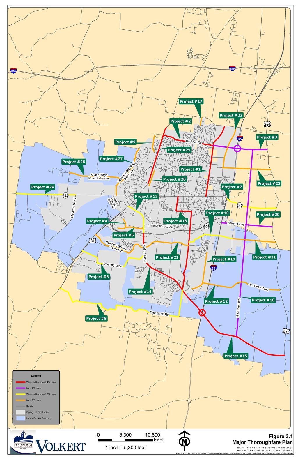
32 C H A P T E R 3. R E C O M M E N D E D P L A N The City of Spring Hill is a member of the Nashville Area Metropolitan Planning Organization (MPO) a regional transportation planning body made up of city and county governments within Davidson, Maury, Robertson, Rutherford, Sumner, Williamson, and Wilson Counties. The MPO is a federally mandated transportation planning organization that produces the region s Long Range Transportation Plan (RTP). The RTP is a plan for all regionally significant transportation-related projects, including roadway and multimodal projects that should be implemented within a 20 to 30-year time frame. The plan is based on several factors, including projected population and employment growth, funding availability, and project necessity (e.g., traffic congestion). In February 2016, the MPO s 2040 RTP was adopted by the MPO Executive Board, which is made up of elected officials from the MPO member jurisdictions discussed in the previous paragraph. In an effort to get recognition and funding of transportation projects within the City of Spring Hill, recommended roadway improvements must be identified. The purpose of this Major Thoroughfare Plan is to establish and identify those improvements. Just as important, this plan is intended to assist the City of Spring Hill in establishing its priority projects for the roadway network in an effort to respond to and prepare for the continuing growth and development in the community. The recommended roadway improvements were developed based on existing and projected traffic volumes, access to and from key origins and destinations, safety and circulation, and actual observed congestion. The improvements are ranked in three priority levels. High priority are ones that are existing needs and should be implemented as soon as funding becomes available. Medium priority are projects that are currently experiencing some congestion and/or need additional access and should be implemented once all high priority projects have been fulfilled. Low priority projects would be beneficial and provide improved circulation and traffic flow, but are not urgent based on congestion or existing access and connectivity. Table 3.1 lists the transportation projects that are proposed as part of this Major Thoroughfare Plan. Figure 3.1 illustrates those projects within the City of Spring Hill. Each individual project is detailed in the following pages. RECOMMENDED PLAN 1
33 TABLE 3.1 MTP PROJECT LIST Project Route Start End Improvement 1 Buckner Lane Duplex Road Thompson s Station Road 2 Buckner Road SR 6/US 31 Buckner Lane Buckner Road Extension Crossings Boulevard Crossings Circle South Buckner Lane Crossings Boulevard Crossings Circle South SR 106/US 431/ Lewisburg Pike Crossings Circle South Kedron Road 6 Denning Lane SR 6/US 31 Kedron Road 7 Duplex Road I Greensmill Road Heritage Bypass Jim Warren Road Jim Warren Road Extension Kedron Road Heritage Campus Port Royal Road Crafton Road 12 Joe Peay Road Rice Road 13 Kedron Road SR 6/US Kedron Road Saturn Parkway SR 106/US 431/ Lewisburg Pike SR 6/US 31 Campbell Station Parkway Crafton Road SR 106/US 431/ Lewisburg Pike SR 106/US 431/ Lewisburg Pike Saturn Parkway Port Royal Road Widen from 2 lanes to 4/5 lanes and realign Widen from 2 lanes to 4/5 lanes Extend as 4-6 lane road Extend as 2 lane road with turn lanes Extend as 2 lane road with turn lanes Widen to provide standard 2 lanes & correct alignment Widen from 2 lanes to 3 lanes & correct alignment Widen to provide standard 2 lanes & correct alignment Construct new 2 lane road Widen to provide standard 2 lanes with turn lanes Extend as 2 lane road Extend as 2 lane road with turn lanes Widen from 2 lanes to 3 lanes Widen from 2 lanes to 4 lanes with turn lanes Length (miles) Priority 2.72 High 1.91 Medium 2.00 High 0.32 Medium 0.97 Medium 2.80 Low 1.92 Medium 6.13 Low 0.61 Medium 1.74 Low 1.62 Low 2.96 Low 1.28 High 2.81 Medium RECOMMENDED PLAN 2
34 TABLE 3.1 MTP PROJECT LIST (CON T) Project Route Start End Improvement 15 Kedron Road N/S Connector New Port Royal Road Extension Port Royal Road 19 Rice Road Saturn Parkway Extension Southern Springs Connector Spring Station Connector Spring Station Drive Extension SR 247/ Beechcroft Road 25 SR 6/US Sugar Ridge Road Extension Town Center Parkway 28 Wall Street Port Royal Road Buckner Road Extension Northern Terminus Duplex Road Rice Road Terminus I-65 Port Royal Road Thompson s Station Road Spring Station Drive Carters Creek Pike Miles Johnson Parkway Sugar Ridge Road western terminus Duplex Road Southern Terminus SR 106/US 431/ Lewisburg Pike Kedron Road (E of I-65) Thompson s Station Road Kedron Road Worthington Lane SR 106/US 431/ Lewisburg Pike SR 6/US 31 Spring Station Drive SR 106/US 431/ Lewisburg Pike Cleburne Road Buckner Road Dr. Robinson Road Wilkes Lane Miles Johnson Parkway Widen from 2 lanes to 4 lanes & construct interchange Construct new 4 lane road Extend as 2 lane road Widen from 2 lanes to 4 lanes Length (miles) Priority 4.70 Low 6.95 Low 0.29 Medium 4.06 Medium New 2 lane road 1.60 Low Extend as 4 lane parkway with turn lanes Construct new 2 lane road, improve Royal Park/John Lunn Road Construct new 2 lane road Extend as 2 lane road with turn lanes Widen to provide standard 2 lanes with turn lanes Widen from 2 lanes to 4/5 lanes Extend as 2 lane road Extend as 2 lane road Extend as 2 lane road 1.80 Low 4.01 Medium 1.60 Low 1.76 Low 2.21 Medium 2.18 High 2.01 Low 2.02 Low 0.61 High RECOMMENDED PLAN 3
35

36 PROJECT 1: BUCKNER LANE Project Location Termini: From Duplex Road to Thompson s Station Road Length: 2.72 miles Improvement: Widen from 2 lanes to 4 lanes with turn lanes as needed and realign Functional Class: Arterial Priority: High Project Summary This improved 4-lane arterial would provide a more efficient north-south route on the northeast side of the City. Buckner Lane parallels I-65 and provides access to numerous residential neighborhoods and Summit High School and Spring Station Middle School. This route is a major connector between Duplex Road and Thompson s Station Road and will become more heavily traveled with the proposed I-65 interchange at Buckner Road. This improvement will include realigning to intersect Thompson s Station Road. Without improvements, Buckner Lane is projected to operate at LOS F in RECOMMENDED PLAN 5

37 PROJECT 2: BUCKNER ROAD Project Location Termini: From SR 6/US 31/Main Street to Buckner Lane Length: 1.91 miles Improvement: Widen from 2 lanes to 4 lanes with turn lanes as needed Functional Class: Arterial Priority: Medium Project Summary This improved 4-lane arterial would provide a more efficient east-west route on the north side of the City. Buckner Road provides access to numerous residential neighborhoods on both sides of the roadway and will serve as the primary east-west route to access the proposed I-65 interchange. Without improvements, Buckner Road is projected to operate at LOS E in RECOMMENDED PLAN 6

38 PROJECT 3: BUCKNER ROAD EXTENSION AND I-65 INTERCHANGE Project Location Termini: From Buckner Lane to SR 106/US 431/Lewisburg Pike Length: 2.00 miles Improvement: New 4-lane roadway with 6 lanes at interchange Functional Class: Arterial Priority: High Project Summary This proposed 4-lane arterial would provide an east-west connection from Buckner Lane to a major state route east of I-65. This project would also provide a new interstate access to I-65 via Diverging Diamond Interchange. The roadway would run through Gateway Land Use. This new roadway would provide much improved access to and from major routes on each side of I-65 and provide travel time benefits into and out of Spring Hill. RECOMMENDED PLAN 7

39 PROJECT 4: CROSSINGS BOULEVARD Project Location Termini: From Crossings Boulevard to Crossings Circle South Length: 0.32 miles Improvement: New 2-lane roadway with turn lanes Functional Class: Collector Priority: Medium Project Summary This proposed 2-lane collector would provide a north connection between The Crossings shopping center and the proposed Crossings Circle South. It would provide a practical connection for traffic without having to utilize SR 6/US 31/Main Street or Saturn Parkway. RECOMMENDED PLAN 8

40 PROJECT 5: CROSSINGS CIRCLE SOUTH Project Location Termini: From Crossings Circle South to Kedron Road Length: 0.97 miles Improvement: New 2- and 4-lane roadway with turn lanes as needed Functional Class: Collector Priority: Medium Project Summary This proposed collector would provide an east-west connection between The Crossings shopping center and Kedron Road. This new road would run parallel to Saturn Parkway. It would provide a practical connection for traffic without having to utilize SR 6/US 31/Main Street or Saturn Parkway. This road would be 2 lanes between the existing terminus of Crossings Circle South and the proposed Crossings Boulevard and 4 lanes to Kedron Road. RECOMMENDED PLAN 9

41 PROJECT 6: DENNING LANE Project Location Termini: From SR 6/US 31/Main Street to Kedron Road Length: 2.80 miles Improvement: Widen to provide standard 2 lanes and correct alignment Functional Class: Collector Priority: Low Project Summary This improved 2-lane collector would provide improved east-west connection on the south side of the City. It would also correct the horizontal alignment and sight distance issues that currently exist. This roadway primarily provides access to residential properties and undeveloped land. RECOMMENDED PLAN 10

42 PROJECT 7: DUPLEX ROAD Project Location Termini: From I-65 to SR 106/US 431/Lewisburg Pike Length: 1.92 miles Improvement: Widen from 2 lanes to 3 lanes and correct alignment Functional Class: Arterial Priority: Medium Project Summary This improved 3-lane arterial would provide improved east-west connection on the east side of I-65. It would also correct the horizontal and vertical alignment and sight distance issues that currently exist. This roadway primarily provides access to residential properties and undeveloped land. This segment of Duplex Road is expected to operate at LOS D in 2040 without improvements. RECOMMENDED PLAN 11

43 PROJECT 8: GREENSMILL ROAD Project Location Termini: From Kedron Road to SR 6/US 31 Length: 6.13 miles Improvement: Widen to provide standard 2-lanes and correct alignment Functional Class: Collector Priority: Low Project Summary This improved 2-lane collector would provide improved east-west connection on the south side of the City. It would also correct the horizontal alignment and sight distance issues that currently exist. This roadway primarily provides access to residential properties and undeveloped land. RECOMMENDED PLAN 12

44 PROJECT 9: HERITAGE BYPASS Project Location Termini: From Heritage Campus to Campbell Station Parkway Length: 0.61 miles Improvement: New 2-lane roadway Functional Class: Collector Priority: Medium Project Summary This proposed 2-lane collector would provide an alternative north-south connection between the Heritage Schools campus and SR 6/US 31/Main Street. The roadway would run through mostly undeveloped land and connect to Wilkes Lane. This roadway would run along the west side of SR 6/US 31/Main Street. RECOMMENDED PLAN 13

45 PROJECT 10: JIM WARREN ROAD Project Location Termini: From Port Royal Road to Crafton Road Length: 1.74 miles Improvement: Widen to provide standard 2 lanes with turn lanes and correct alignment Functional Class: Collector Priority: Low Project Summary This widened 2-lane collector would provide improved east-west access on the east side of the City, including crossing I-65. It would also improve the narrow lanes that currently exist. This roadway provides access to multiple residential properties and undeveloped areas. RECOMMENDED PLAN 14

46 PROJECT 11: JIM WARREN ROAD EXTENSION Project Location Termini: From Crafton Road to SR 106/US 431/Lewisburg Pike Length: 1.62 miles Improvement: New 2-lane roadway Functional Class: Collector Priority: Low Project Summary This proposed 2-lane collector would provide an east-west connection through the rural area that lies between Crafton Road and SR 106/US 431/Lewisburg Pike. The roadway would run through mostly undeveloped properties. It would provide a logical connection from the City to a major highway. RECOMMENDED PLAN 15

47 PROJECT 12: JOE PEAY ROAD Project Location Termini: From Rice Road to SR 106/US 431/Lewisburg Pike Length: 2.96 miles Improvement: New 2-lane roadway with turn lanes Functional Class: Collector Priority: Low Project Summary This proposed 2-lane collector would provide an east-west connection from SR 106/US 431/Lewisburg Pike to near the proposed extension of Rice Road. This new road would provide an improved and alternative connection across I-65 on the southeast side of the City. RECOMMENDED PLAN 16

48 PROJECT 13: KEDRON ROAD Project Location Termini: From SR 6/US 31/Main Street to Saturn Parkway Length: 1.28 miles Improvement: Widen from 2 lanes to 3 lanes Functional Class: Arterial Priority: High Project Summary This improved 3-lane arterial would provide improved access to the high-demand connection between Saturn Parkway and SR 6/US 31/Main Street. This roadway provides access to several local routes and residential properties. This segment of Kedron Road is expected to operate at LOS E in 2040 without improvements. RECOMMENDED PLAN 17

49 PROJECT 14: KEDRON ROAD Project Location Termini: From Saturn Parkway to Port Royal Road Length: 2.81 miles Improvement: Widen from 2 lanes to 4 lanes with turn lanes Functional Class: Arterial Priority: Medium Project Summary This improved 4-lane arterial would provide a more efficient north-south route on the south side of the City. This roadway traverses residential property and undeveloped areas. However, this route is a major connector between Saturn Parkway and Port Royal Road. Without improvements, Kedron Road is projected to operate at LOS E in RECOMMENDED PLAN 18

50 PROJECT 15: KEDRON ROAD Project Location Termini: From Port Royal Road to SR 106/US 431/Lewisburg Pike Length: 4.70 miles Improvement: Widen from 2 lanes to 4 lanes and construct interchange Functional Class: Arterial Priority: Low Project Summary This improved 4-lane collector would provide a more efficient north-south route on the southeast side of the City. This roadway traverses primarily undeveloped areas. However, this route would include an interchange at I-65 and would be a major connector between Port Royal Road and SR 106/US 431/Lewisburg Pike. With the interchange, this roadway would run through future Gateway Land Use. Without improvements, a segment of Port Royal Road is projected to operate at LOS E in RECOMMENDED PLAN 19

51 PROJECT 16: N/S CONNECTOR Project Location Termini: From Buckner Road Extension to Kedron Road (E. of I-65) Length: 6.95 miles Improvement: New 4-lane roadway Functional Class: Arterial Priority: Low Project Summary This proposed 4-lane arterial would provide a needed north-south connection through the rural area on the east side of I-65. The roadway would run through a multitude of existing and future residential land uses. This new roadway would help with connectivity once the Buckner Road extension and I-65 interchange is complete. RECOMMENDED PLAN 20

52 PROJECT 17: NEW PORT ROYAL ROAD EXTENSION Project Location Termini: From Northern Terminus to Thompson s Station Road Length: 0.29 miles Improvement: New 2-lane road Functional Class: Collector Priority: Medium Project Summary This proposed 2-lane collector would provide a practical connection between the residential area along New Port Royal Road and Thompson s Station Road. The roadway would run through mostly undeveloped land. This roadway would provide an additional and alternative north-south route on the north side of the City. RECOMMENDED PLAN 21

53 PROJECT 18: PORT ROYAL ROAD Project Location Termini: From Duplex Road to Kedron Road Length: 4.06 miles Improvement: Widen from 2 lanes to 4 lanes Functional Class: Arterial Priority: Medium Project Summary This improved 4-lane arterial would provide a more efficient north-south route on the southeast side of the City. This roadway traverses residential property and undeveloped areas south of Saturn Parkway and provides access to multiple commercial developments and residential properties north of Saturn Parkway. The improvement would also correct the horizontal alignment and sight distance issues that currently exist. This route is a major connector between Duplex Road and Kedron Road, and provides access to the new Port Royal Park. Without improvements, Port Royal Road is projected to operate at LOS F in RECOMMENDED PLAN 22

54 PROJECT 19: RICE ROAD Project Location Termini: From Terminus of Rice Road to Worthington Lane Length: 1.60 miles Improvement: New 2-lane roadway Functional Class: Collector Priority: Low Project Summary This new 2-lane collector would provide improved north-south access on the southeast side of the City. It would provide an alternative to traffic utilizing Port Royal Road. This roadway would traverse through mostly undeveloped property. RECOMMENDED PLAN 23

55 PROJECT 20: SATURN PARKWAY EXTENSION Project Location Termini: From I-65 to SR 106/US 431/Lewisburg Pike Length: 1.80 miles Improvement: New 4-lane parkway Functional Class: Arterial Priority: Low Project Summary This new arterial roadway would extend the existing Saturn Parkway to SR 106/US 431/Lewisburg Pike. This is a logical east-west connection that would only add to future east-west connections on the east side of I-65. This new roadway would traverse residential and undeveloped properties, as well as a couple of local roadways. RECOMMENDED PLAN 24

56 PROJECT 21: SOUTHERN SPRINGS CONNECTOR Project Location Termini: From Port Royal Road to SR 6/US 31/Main Street Length: 4.01 miles Improvement: New 2-lane road, and improve Royal Park/John Lunn Road Functional Class: Collector Priority: Medium Project Summary This proposed 2-lane collector would provide a practical east-west connection Port Royal Road and the new Southern Springs development. The roadway would run through mostly undeveloped land to connect residential neighborhoods. This roadway would provide an additional and alternative east-west route on the south side of the City. RECOMMENDED PLAN 25

57 PROJECT 22: SPRING STATION CONNECTOR Project Location Termini: From Thompson s Station Road to Spring Station Drive Length: 1.60 miles Improvement: New 2-lane roadway Functional Class: Collector Priority: Low Project Summary This proposed 2-lane collector would provide an alternative north-south connection between Summit High School and Spring Station Middle School and Thompson s Station Road. The roadway would run through mostly undeveloped land that is planned to be converted to a regional office and commercial development in the future. This roadway would run parallel to I-65 and would provide an additional and alternative north-south route on the northeast side of the City. RECOMMENDED PLAN 26

58 PROJECT 23: SPRING STATION DRIVE EXTENSION Project Location Termini: From Spring Station Drive to SR 106/US 431/Lewisburg Pike Length: 1.76 miles Improvement: New 2-lane roadway with turn lanes Functional Class: Collector Priority: Low Project Summary This proposed 2-lane collector would provide an east-west connection from Summit High School and Spring Station Middle School to SR 106/US 431/Lewisburg Pike. This new road would provide an improved and alternative connection across I-65 on the northeast side of the City. RECOMMENDED PLAN 27

59 PROJECT 24: SR 247/BEECHCROFT ROAD Project Location Termini: From Carters Creek Pike to Cleburne Road Length: 2.21 miles Improvement: Widen to provide standard 3 lanes Functional Class: Arterial Priority: Medium Project Summary This widened 3-lane arterial would provide improved east-west access on the west side of the City. It would also improve the narrow lanes that currently exist. This roadway provides access to multiple residential properties as well as access to I-840 via Carters Creek Pike. A portion of this segment of SR 247/Beechcroft Road is expected to operate at LOS E in 2040 without improvements. RECOMMENDED PLAN 28

60 PROJECT 25: SR 6/US 31/MAIN STREET Project Location Termini: From Miles Johnson Parkway to Buckner Road Length: 2.18 miles Improvement: Widen from 2 lanes to 4 lanes with turn lanes as needed Functional Class: Arterial Priority: High Project Summary This improved 4-lane arterial would provide a more efficient north-south route on the north side of the City. This roadway traverses multiple commercial and business developments and provides access to numerous residential neighborhoods. Without improvements, SR 6/US 31/Main Street is projected to operate at LOS F in RECOMMENDED PLAN 29

61 PROJECT 26: SUGAR RIDGE ROAD EXTENSION Project Location Termini: From Sugar Ridge Road eastern terminus to Dr. Robinson Road Length: 2.01 miles Improvement: New 2-lane roadway Functional Class: Collector Priority: Low Project Summary This proposed 2-lane collector would provide an improved and alternative east-west connection on the northwest side of the City. This new road would traverse mainly undeveloped land and some residential properties. The new extension would intersect Dr. Robinson Road across from Lakeview Road. RECOMMENDED PLAN 30

62 PROJECT 27: TOWN CENTER PARKWAY EXTENSION Project Location Termini: From Duplex Road to Wilkes Lane Length: 2.02 miles Improvement: New 2-lane roadway Functional Class: Collector Priority: Low Project Summary This new 2-lane collector would provide an additional north-south connection between Town Center Parkway near Kedron Parkway to Wilkes Lane and the commercial development near Campbell Station Parkway. This new roadway would likely go through several existing local roads and would parallel the railroad. RECOMMENDED PLAN 31

63 PROJECT 28: WALL STREET Project Location Termini: From Southern Terminus to Miles Johnson Parkway Length: 0.61 miles Improvement: New 2-lane roadway Functional Class: Collector Priority: High Project Summary This proposed 2-lane collector would provide a practical link between the commercial development along Belshire Way to Miles Johnson Parkway. The roadway would run through mostly undeveloped land. This roadway would provide a logical north-south connection on the north side of the City. RECOMMENDED PLAN 32
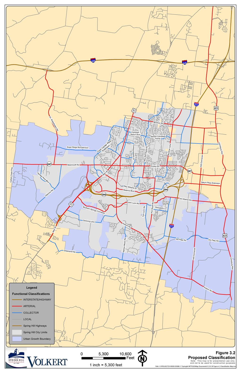
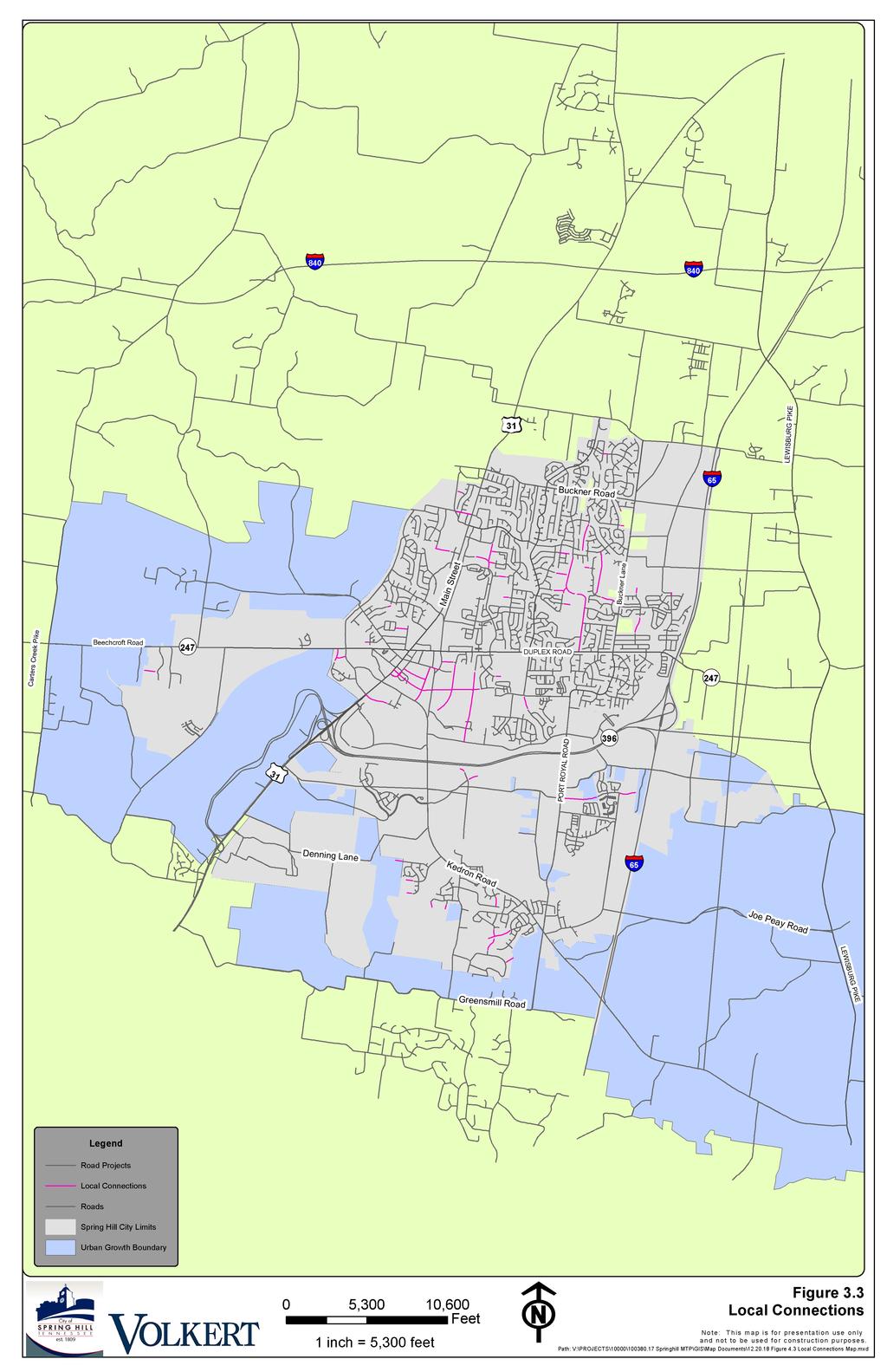
64 F U T U R E C L A S S I F I C A T I O N M AP As described in the Existing Conditions report, four primary functional classes of roadways are provided within the study area. Interstates and Freeways are the highest classification of roadways utilized for long-distance travel. Arterials are a class of roads serving large traffic movements for moderate lengths of travel. Collector roadways have the primary purpose of collecting traffic from local roadways and distributing it to its destination or to an arterial roadway. Figure 3.2 illustrates existing and proposed Roadway Functional Classifications within the City of Spring Hill. Local streets are not considered major thoroughfares, as their primary function is to provide direct access to land with little emphasis on the movement of through traffic so are, therefore, not classified. However, there are several local connections that are important to the connectivity and circulation for the City of Spring Hill. These connections are identified in Figure 3.3, which details these future local connections that are recommended as development occurs and funding becomes available. RECOMMENDED PLAN 33
65
66
Chapter 5 Future Transportation
 Chapter 5 Future Transportation The Future Land Use Plan identifies the desired land use designations. The land uses desired for Crozet depend, in large part, on the success of the transportation system,
City of Wayzata Comprehensive Plan 2030 Transportation Chapter: Appendix A
 A1. Functional Classification Table A-1 illustrates the Metropolitan Council s detailed criteria established for the functional classification of roadways within the Twin Cities Metropolitan Area. Table
City of Homewood Transportation Plan
 City of Homewood Transportation Plan Prepared for: City of Homewood, Alabama Prepared by: Skipper Consulting, Inc. May 2007 TABLE OF CONTENTS INTRODUCTION... 1 BACKGROUND INFORMATION... 1 EXISTING TRANSPORTATION
Goodlettsville Bicycle and Pedestrian Plan Executive Summary
 Goodlettsville Bicycle and Pedestrian Plan July 2010 In Cooperation with the Nashville Area Metropolitan Planning Executive Organization Summary Introduction Progressive and forward thinking communities
3.0 Future Conditions
 3.0 Future Conditions In order to be able to recommend appropriate improvements to the transportation system of the Town, it is important to first understand the nature and volume of traffic that is expected
TRAFFIC IMPACT STUDY COMPREHENSIVE UPDATE TOWN OF THOMPSON S STATION, TENNESSEE PREPARED FOR: THE TOWN OF THOMPSON S STATION
 TRAFFIC IMPACT STUDY COMPREHENSIVE UPDATE TOWN OF THOMPSON S STATION, TENNESSEE PREPARED FOR: THE TOWN OF THOMPSON S STATION Transportation Consultants, LLC 1101 17 TH AVENUE SOUTH NASHVILLE, TN 37212
o n - m o t o r i z e d transportation is an overlooked element that can greatly enhance the overall quality of life for the community s residents.
 N o n - m o t o r i z e d transportation is an overlooked element that can greatly enhance the overall quality of life for the community s residents. 84 Transportation CHAPTER 11 INTRODUCTION Transportation
Basalt Creek Transportation Refinement Plan Recommendations
 Basalt Creek Transportation Refinement Plan Recommendations Introduction The Basalt Creek transportation planning effort analyzed future transportation conditions and evaluated alternative strategies for
Highway 111 Corridor Study
 Highway 111 Corridor Study June, 2009 LINCOLN CO. HWY 111 CORRIDOR STUDY Draft Study Tea, South Dakota Prepared for City of Tea Sioux Falls Metropolitan Planning Organization Prepared by HDR Engineering,
JONESBORO HIGHWAY 63 HIGHWAY 18 CONNECTOR STUDY
 JONESBORO HIGHWAY 63 HIGHWAY 18 CONNECTOR STUDY Craighead County May 2007 JONESBORO HIGHWAY 63 HIGHWAY 18 CONNECTOR STUDY Craighead County May 2007 Prepared by Planning and Research Division Arkansas State
5.0 Roadway System Plan
 Southwest Boise Transportation Study Page 16 5.0 Roadway System Plan The Roadway System Plan outlines roadway improvements in the Initial Study Area. It forecasts future deficiencies on the arterial system,
4. ENVIRONMENTAL IMPACT ANALYSIS 9. TRANSPORTATION AND TRAFFIC
 4. ENVIRONMENTAL IMPACT ANALYSIS 9. TRANSPORTATION AND TRAFFIC 4.9.1 INTRODUCTION The following section addresses the Proposed Project s impact on transportation and traffic based on the Traffic Study
Route 7 Corridor Study
 Route 7 Corridor Study Executive Summary Study Area The following report analyzes a segment of the Virginia State Route 7 corridor. The corridor study area, spanning over 5 miles in length, is a multi
CITY OF COCOA BEACH 2025 COMPREHENSIVE PLAN. Section VIII Mobility Element Goals, Objectives, and Policies
 CITY OF COCOA BEACH 2025 COMPREHENSIVE PLAN Section VIII Mobility Element Goals, Objectives, and Policies Adopted August 6, 2015 by Ordinance No. 1591 VIII MOBILITY ELEMENT Table of Contents Page Number
Recommended Roadway Plan Section 2 - Land Development and Roadway Access
 Recommended Roadway Plan Section 2 - Land Development and Roadway Access SECTION 2 Land Development and Roadway Access 2.1 Land Use and Access Management The Federal Highway Administration (FHWA) defines
DRAFT BUENA VISTA 2020 TRANSPORTATION PLAN
 DRAFT BUENA VISTA 2020 TRANSPORTATION PLAN DEVELOPED BY THE TRANSPORTATION PLANNING DIVISION OF THE VIRGINIA DEPARTMENT OF TRANSPORTATION IN COOPERATION WITH THE U.S. DEPARTMENT OF TRANSPORTATION, FEDERAL
Circulation in Elk Grove includes: Motor vehicles, including cars and trucks
 Circulation, as it is used in this General Plan, refers to the many ways people and goods move from place to place in Elk Grove and the region. Circulation in Elk Grove includes: Motor vehicles, including
ADOT Statewide Bicycle and Pedestrian Program Summary of Phase IV Activities APPENDIX B PEDESTRIAN DEMAND INDEX
 ADOT Statewide Bicycle and Pedestrian Program Summary of Activities APPENDIX B PEDESTRIAN DEMAND INDEX May 24, 2009 Pedestrian Demand Index for State Highway Facilities Revised: May 29, 2007 Introduction
Clackamas County Comprehensive Plan
 ROADWAYS The County s road system permits the movement of goods and people between communities and regions, using any of a variety of modes of travel. Roads provide access to virtually all property. They
APPENDIX G: INTERSECTION NEEDS AT OKEECHOBEE BOULEVARD
 APPENDIX G: INTERSECTION NEEDS AT OKEECHOBEE BOULEVARD INTERSECTION NEEDS AT SR 7 and OKEECHOBEE BOULEVARD SR 7 Extension Project Development and Environment (PD&E) Study From Okeechobee Boulevard (SR
Classification Criteria
 SCHEDULE D TO RECOMMENDED OFFICIAL PLAN AMENDMENT NO. 40 SCHEDULE C-4 Road Criteria Criteria Traffic Service Objective Land Service/Access Typical Daily Traffic Volume Flow characteristics Travel Speed
Regional Transportation Needs Within Southeastern Wisconsin
 Regional Transportation Needs Within Southeastern Wisconsin #118274 May 24, 2006 1 Introduction The Southeastern Wisconsin Regional Planning Commission (SEWRPC) is the official areawide planning agency
Executive Summary Route 30 Corridor Master Plan
 Route Corridor Master Plan Project Overview The Route Corridor Master Plan is a coordinated multimodal transportation and land use plan for the entire stretch of Route through East Whiteland Township,
City of Memphis On-Street Parking Modification Guidelines
 City of Memphis Effective Date: December 1, 2013 Bicycle/Pedestrian Program 125 N. Main Street Memphis, TN 38103 (901) 576-6710 www.bikepedmemphis.com City of Memphis Executive Summary It is current practice
ACTIVE TRANSPORTATION
 ACTIVE TRANSPORTATION Mobility 2040 Supported Goals Improve the availability of transportation options for people and goods. Support travel efficiency measures and system enhancements targeted at congestion
Proposed Action, Purpose and Need Technical Memorandum
 Proposed Action, Purpose and Need Technical Memorandum MoPac (State Loop 1) Intersections, Austin District From North of Slaughter Lane to South of La Crosse Avenue CSJ: 3136-01-015 Travis County, Texas
M-58 HIGHWAY ACCESS MANAGEMENT STUDY Mullen Road to Bel-Ray Boulevard. Prepared for CITY OF BELTON. May 2016
 M-58 HIGHWAY ACCESS MANAGEMENT STUDY Prepared for CITY OF BELTON By May 2016 Introduction Missouri State Highway 58 (M-58 Highway) is a major commercial corridor in the City of Belton. As development has
Purpose and Need. Chapter Introduction. 2.2 Project Purpose and Need Project Purpose Project Need
 Chapter 2 Purpose and Need 2.1 Introduction The El Camino Real Bus Rapid Transit (BRT) Project (Project) would make transit and other transportation improvements along a 17.6-mile segment of the El Camino
Chapter 4 Traffic Analysis
 Chapter 4 Traffic Analysis PURPOSE The traffic analysis component of the K-68 Corridor Management Plan incorporates information on the existing transportation network, such as traffic volumes and intersection
Highway 49, Highway 351 and Highway 91 Improvements Feasibility Study Craighead County
 Highway 49, Highway 351 and Highway 91 Improvements Feasibility Study Craighead County Executive Summary March 2015 Highway 49, Highway 351 and Highway 91 Improvements Feasibility Study Craighead County
Provo City Transportation Master Plan
 Provo City Transportation Master Plan Provo, Utah Adopted: September, 011 UT09-1 1 West Mayflower Way, Ste. Lehi, Utah 80 p. 801/. www.halesengineering.com September, 011 EXECUTIVE SUMMARY Provo City is
University Hill Transportation Study Technical Memorandum Alternatives Modeling and Analysis May 2007
 Technical Memorandum May 2007 Syracuse Metropolitan Transportation Council Edwards and Kelcey with Wallace Roberts and Todd Alta Planning and Design CONTENTS SECTION ONE- INTRODUCTION...1 SECTION TWO-
METHODOLOGY. Signalized Intersection Average Control Delay (sec/veh)
") Chapter 5 Traffic Analysis 5.1 SUMMARY US /West 6 th Street assumes a unique role in the Lawrence Douglas County transportation system. This principal arterial street currently conveys commuter traffic
Chapter 5 Traffic Analysis 5.1 SUMMARY US /West 6 th Street assumes a unique role in the Lawrence Douglas County transportation system. This principal arterial street currently conveys commuter traffic
City of Gainesville Transportation/Roadway Needs PROJECT SUMMARY
 A1 Roadway Resurfacing $23,846,000 TYPE: Preservation of existing system Roadway resurfacing A2 Signal Replacement $6,000,000 TYPE: Preservation of existing system Replace traffic signals. B1 W 6th St
5 CIRCULATION AND STREET DESIGN
 5 CIRCULATION AND STREET DESIGN This chapter describes circulation and streetscape improvements proposed for the Northwest Chico Specific Plan Area. It includes detailed design specifications for existing
Solana Beach Comprehensive Active Transportation Strategy (CATS)
") Solana Beach Comprehensive Active Transportation Strategy (CATS) 3.0 Goals & Policies The Solana Beach CATS goals and objectives outlined below were largely drawn from the Solana Beach Circulation Element
Solana Beach Comprehensive Active Transportation Strategy (CATS) 3.0 Goals & Policies The Solana Beach CATS goals and objectives outlined below were largely drawn from the Solana Beach Circulation Element
STREET AND HIGHWAY PLAN
 STREET AND HIGHWAY PLAN Introduction The street and highway system in the Winston-Salem Urban Area consists of thousands of miles of traffic carrying facilities, ranging from short local residential streets
Appendix 3 Roadway and Bike/Ped Design Standards
 Appendix 3 Roadway and Bike/Ped Design Standards OTO Transportation Plan 2040 4/20/2017 Page A3-1 Adopted Standards The adopted OTO Design Standards and Major Thoroughfare Plan are contained herein.
Gordon Proctor Director Policy on Accommodating Bicycle and Pedestrian Travel on ODOT Owned or Maintained Facilities
 Approved: Policy: 20-004(P) Responsible Office: Planning Gordon Proctor Director Policy on Accommodating Bicycle and Pedestrian Travel on ODOT Owned or Maintained Facilities I. POLICY STATEMENT: This policy
CONNECTIVITY PLAN. Adopted December 5, 2017 City of Virginia Beach
 CONNECTIVITY PLAN Adopted December 5, 2017 City of Virginia Beach CONTENTS 1.0 Background & Purpose... 2 2.0 Existing Inventory & Analysis... 3 ViBe District Existing Walking Conditions... 4 3.0 ViBe District
Living Streets Policy
 Living Streets Policy Introduction Living streets balance the needs of motorists, bicyclists, pedestrians and transit riders in ways that promote safety and convenience, enhance community identity, create
Project Description Form 6V
 Project Description Form 6V Basic Project Information Submitting Jurisdiction/Agency: Prince William County Project Title: Route 15 Widening: Route 55 to south of RR tracks & Construct RR Overpass Project
TRASBURG RANSPORTATION
 TRASBURG RANSPORTATION LAN DEVELOPED BY THE TRANSPORTATION PLANNING DIVISION OF THE VIRGINIA DEPARTMENT OF TRANSPORTATION IN COOPERATION WITH THE U.S. DEPARTMENT OF TRANSPORTATION, FEDERAL HIGHWAY ADMINISTRATION
4. Action Plan & Projects
 4. Action Plan & Projects 45 46 ACTION PLAN AND PROJECTS The Action Plan organizes the list of transportation projects described in the Mobility Framework Plan section into short-term (0-5 years) and long-term
TRAFFIC IMPACT STUDY CRITERIA
 Chapter 6 - TRAFFIC IMPACT STUDY CRITERIA 6.1 GENERAL PROVISIONS 6.1.1. Purpose: The purpose of this document is to outline a standard format for preparing a traffic impact study in the City of Steamboat
INTRODUCTION THOROUGHFARE SYSTEM CLASSIFICATIONS
 INTRODUCTION The thoroughfare plan will assist public officials in the development of a specialized system for efficient and safe movement of vehicular traffic while minimizing potential conflicts with
Chapter 6 Transportation Plan
 Chapter 6 Transportation Plan Transportation Plan Introduction Chapter 6 Transportation Plan Transportation Plan Introduction This chapter describes the components of Arvada s transportation system, comprised
Figure 1: East West Connector Alignment Alternatives Concept Drawing
 Page 2 of 9 Figure 1: East West Connector Alignment Alternatives Concept Drawing The Montebello Drive extension will run north south and connect Wilsonville Road to the Boones Ferry Road to Brown Road
INTERMODAL TRANSPORTATION PLAN
 INTRODUCTION INTERMODAL TRANSPORTATION PLAN Effective intermodal transportation implies a public policy for actively decreasing the demand for automobile trips and consequently reducing automobile related
CHAPTER 4: IDENTIFICATION OF ROAD SYSTEM DEFICIENCIES: TRANSPORTATION PLANNING MODEL
 CHAPTER 4: IDENTIFICATION OF ROAD SYSTEM DEFICIENCIES: TRANSPORTATION PLANNING MODEL I. INTRODUCTION Transportation planning models are the primary tools used to predict future travel conditions. With
CITY OF BLOOMINGTON COMPLETE STREETS POLICY
 CITY OF BLOOMINGTON COMPLETE STREETS POLICY POLICY OBJECTIVE: The City of Bloomington will enhance safety, mobility, accessibility and convenience for transportation network users of all ages and abilities,
Waterford Lakes Small Area Study
 Waterford Lakes Small Area Study Existing Traffic Conditions PREPARED FOR: ORANGE COUNTY PUBLIC WORKS DEPARTMENT TRAFFIC ENGINEERING DIVISION ORLANDO, FLORIDA PREPARED WITH: INWOOD CONSULTING ENGINEERS
MOUNTAIN HOUSE SPECIFIC PLAN I 9.1 INTRODUCTION ASSUMPTIONS TRANSPORTATION FACILITIES TRANSPORTATION IMPROVEMENTS PHASING 9.
 CHAPTER NINE: TRANSPORTATION AND CIRCULATION 9.1 INTRODUCTION 9.1 9.2 ASSUMPTIONS 9.1 9.3 TRANSPORTATION FACILITIES 9.1 9.4 TRANSPORTATION IMPROVEMENTS PHASING 9.3 LIST OF FIGURES LIST OF TABLES Figure
Moving Towards Complete Streets MMLOS Applications
 Moving Towards Complete Streets MMLOS Applications Transportation Education Series May 18 th, 2012 It s not just for cars! Presentation Overview The Complete Streets Movement What is Multi-Modal Level
Goal 3: Foster an environment of partnerships and collaboration to connect our communities and regions to one another.
 Non-Motorized Transportation Plan (NMTP) Draft Vision, Goal and,, Tri-County Regional Planning Commission (TCRPC) Purpose The purpose of the Tri-County Regional Planning Commission (TCRPC) Non-Motorized
EXECUTIVE SUMMARY OF CALEDON TRANSPORTATION NEEDS STUDY
 EXECUTIVE SUMMARY OF CALEDON TRANSPORTATION NEEDS STUDY The Caledon Transportation Needs Study has been undertaken as a joint project by the Town of Caledon and the Region of Peel to determine the existing
TABLE OF CONTENTS TABLE OF CONTENTS... I APPENDICES... III LIST OF EXHIBITS... V LIST OF TABLES... VII LIST OF ABBREVIATED TERMS...
 TABLE OF CONTENTS TABLE OF CONTENTS... I APPENDICES... III LIST OF EXHIBITS... V LIST OF TABLES... VII LIST OF ABBREVIATED TERMS... IX 1 INTRODUCTION... 1 1.1 Project Overview... 1 1.2 Analysis Scenarios...
APPENDIXB. Traffic Operations Technical Memorandum
 APPENDIXB Traffic Operations Technical Memorandum Environmental Assessment - Lincoln County, SD 85 th Street: Sundowner Avenue to Louise Avenue November 2017 MEMORANDUM Transportation Jim Kollbaum, PE
Lee s Summit, Missouri Thoroughfare Master Plan
 Title Text Interstate Reg. 12 pt. Lee s Summit, Missouri Thoroughfare Master Plan April 2006 Lee s Summit, Missouri Thoroughfare Master Plan i Table of Contents Chapter 1 Introduction 1.1 Purpose of the
Chapter 2. Bellingham Bicycle Master Plan Chapter 2: Policies and Actions
 Chapter 2 Bellingham Bicycle Master Plan Chapter 2: Policies and Actions Chapter 2: Policies and Actions The Bicycle Master Plan provides a road map for making bicycling in Bellingham a viable transportation
East Burke Transportation, Safety and Capacity Improvements
 East Burke Transportation, Safety and Capacity Improvements The purpose of this project is to increase mobility and improve safety for pedestrians, cyclists, and motor vehicles along VT Route 114 in the
Staunton. Transportation Plan. Transportation Planning Division. Virginia Department of Transportation
 2020 Transportation Plan Developed for the Transportation Planning Division of the Virginia Department of Transportation in cooperation with the U.S. Department of Transportation, Federal Highway Administration
A COMPREHENSIVE APPROACH TO TRANSPORTATION AT SUNTRUST PARK AND THE BATTERY ATLANTA
 A COMPREHENSIVE APPROACH TO TRANSPORTATION AT SUNTRUST PARK AND THE BATTERY ATLANTA Overview The Atlanta Braves strategically selected the location for SunTrust Park to provide an environment rich in transportation
Spring Hill Bicycle and Greenway Plan
 Spring Hill Bicycle and Greenway Plan Adopted: October 19, 2015 Revised February 20, 2018 City of Spring Hill, Tennessee Prepared by Volkert, Inc. 1 Spring Hill Bicycle and Greenway Plan TABLE OF CONTENTS
Welcome. Background. Goals. Vision
 Welcome The formal Public Information Centre (PIC) for the Transportation Master Plan How We GO will be held in early 2017. At that time we will present the recommended transportation system for Niagara
2.0 Existing Conditions
 20 2.0 Existing Conditions 2.1 Land Use, Future Growth Patterns, Physical Barriers Geographic Overview Sutter County s land use pattern is characterized by extensive agricultural areas, significant natural
Transportation Assessment
 Transportation Assessment Midtown Open House February 10, 2018 Overview Midtown in Focus Overview & Purpose of Today Transportation Assessment overview Summary of Transportation work to date Review & Analysis
ARTINSVILLE ENRY OUNTY REA RANSPORTATION TUDY
 ARTINSVILLE ENRY OUNTY REA RANSPORTATION TUDY DEVELOPED BY THE TRANSPORTATION AND MOBILITY PLANNING DIVISION OF THE VIRGINIA DEPARTMENT OF TRANSPORTATION IN COOPERATION WITH THE U.S. DEPARTMENT OF TRANSPORTATION,
TRANSPORTATION & MOBILITY
 TRANSPORTATION & MOBILITY ROADWAY SYSTEM There are approximately 40 miles of roadways in Manitou Springs. For planning purposes, roadways are typically assigned a functional classification which defines
TOWN OF CHAPEL HILL POLICY AND PROCEDURES FOR TRAFFIC CALMING MEASURES
 TOWN OF CHAPEL HILL POLICY AND PROCEDURES FOR TRAFFIC CALMING MEASURES (Adopted by the Town Council on June 30, 2004) (Revised December 6, 2010) (Revised February 8, 2016) POLICY AND PROCEDURES FOR TRAFFIC
TRANSPORTATION NEEDS ASSESSMENT
 TRANSPORTATION NEEDS ASSESSMENT A travel demand analysis was carried out to determine the operational issues and the potential benefit that adding traffic capacity would have on the road network. All the
2040 MAJOR THOROUGHFARE PLAN
 2040 MAJOR THOROUGHFARE PLA City of Spring Hill, Tennessee ADOPTED MAY 26, 2015 Major Thoroughfare Plan Update City of Spring Hill Adopted May 26, 2015 This update has been prepared at the request of the
WELCOME TO OPEN HOUSE # 1 June 14, 2017
 Langstaff Road Weston Road to Highway 7 Class Environmental Assessment Study WELCOME TO OPEN HOUSE # 1 June 14, 2017 Please sign in and join our mailing list Purpose of Open House #1 & Study Area York
ARRENTON RANSPORTATION
 ARRENTON RANSPORTATION LAN DEVELOPED BY THE TRANSPORTATION PLANNING DIVISION OF THE VIRGINIA DEPARTMENT OF TRANSPORTATION IN COOPERATION WITH THE U.S. DEPARTMENT OF TRANSPORTATION, FEDERAL HIGHWAY ADMINISTRATION
TRAFFIC STUDY GUIDELINES Clarksville Street Department
 TRAFFIC STUDY GUIDELINES Clarksville Street Department 9/1/2009 Introduction Traffic studies are used to help the city determine potential impacts to the operation of the surrounding roadway network. Two
SECTION 1 - TRAFFIC PLANNING
 SECTION 1 - TRAFFIC PLANNING 1.1 TRAFFIC OPERATIONS 1.1.1 Roadway Functional Classification The Multnomah County Comprehensive Framework Plan s Policy 34: Trafficways and the Functional Classification
CITY OF ALPHARETTA DOWNTOWN MASTER PLAN TRAFFIC EVALUATION
 CITY OF ALPHARETTA DOWNTOWN MASTER PLAN TRAFFIC EVALUATION June 2015 CITY OF ALPHARETTA DOWNTOWN MASTER PLAN TRAFFIC EVALUATION Introduction The Alpharetta Downtown Master Plan was developed in the fall
Owl Canyon Corridor Project Overview and Summary
 Owl Canyon Corridor Project Overview and Summary December 22, 2008 The Owl Canyon corridor (generally the connection between the I-25 / Larimer County Road 70 interchange and the US 287 / Larimer County
3.9 Recreational Trails and Natural Areas
 3.9 Recreational Trails and Natural Areas 3.9.1 Introduction Parks and other recreational facilities such as trails, bicycle routes, and open space are important community resources. This section discusses
Tulsa Metropolitan Area LONG RANGE TRANSPORTATION PLAN
 Tulsa Metropolitan Area LONG RANGE TRANSPORTATION PLAN Indian Nations Council of Governments August 2005 CONTACTING INCOG In developing the Destination 2030 Long Range Transportation Plan, INCOG s Transportation
CITY OF LUCAS 2014 MASTER THOROUGHFARE PLAN
 INTRODUCTION CITY OF LUCAS 2014 MASTER THOROUGHFARE PLAN A thoroughfare system is intended to provide an effective means of moving vehicles within and through a city. The thoroughfare plan will assist
Third Street Bridge & Corridor Project
 Third Street Bridge & Corridor Project Preparation for the FY2018 budget to commence October 1, 2017, includes funding to address a project that has been considered since 1994. The Third Street bridge
Town of Orangetown Neighborhood Traffic Calming Program
 Town of Orangetown Neighborhood Traffic Calming Program Table of Contents I Introduction a. Purpose b. Key to successful projects c. What is Traffic Calming? II III IV V VI VII Definitions Street Classification
Subject: Solberg Avenue / I-229 Grade Separation: Traffic Analysis
 MEMORANDUM Transportation Bill Troe, AICP Jason Carbee, AICP 12120 Shamrock Plaza Suite 300 Omaha, NE 68154 (402) 334-8181 (402) 334-1984 (Fax) To: Project File Date: Subject: Solberg Avenue / I-229 Grade
T A B L E OF C O N T E N T S
 T A B L E OF C O N T E N T S PART III SUBDIVISION REGULATIONS OF THE DEPARTMENT OF PUBLIC WORKS, C & C D PAGE PAGE Responsibility for Development of Streets......... 29 Right-of-Way Widths...... 37 Purpose...........
TRAFFIC ACTION PLAN. North Central Neighborhood CITY OF SAN MATEO
 TRAFFIC ACTION PLAN North Central Neighborhood CITY OF SAN MATEO Draft February 2017 Table of Contents Introduction... 1 The Traffic Forum Process... 4 Neighborhood Traffic Issues... 6 Neighborhood Recommendations
This page intentionally left blank.
 This page intentionally left blank. COMMUNITY Coweta Community Overview Coweta Coweta, a residential community located in Wagoner County, is a suburb of Tulsa situated southeast of the metropolitan area
West Dimond Blvd Upgrade Jodhpur Street to Sand Lake Road
 West Dimond Blvd Jodhpur St to Sand Lake CSS Transportation Project Summary Municipality of Anchorage Project # 05 005 Project Manager: John Smith, P.E. (MOA PM&E) Project Administrator: Julie Makela,
Town of Brownsburg 2020 Thoroughfare Plan
 Town of Brownsburg 2020 Thoroughfare Plan November 23, 2009 ACKNOWLEDGEMENTS This statement is in appreciation for all those who participated in the preparation of the Town of Brownsburg Thoroughfare Plan.
MASTER THOROUGHFARE PLAN
 MASTER THOROUGHFARE PLAN Master Thoroughfare Plan Update November 2015 Prepared for Town of Northlake AVO 30659 11/11/2015 1201 North Bowser Road Richardson, Texas 75081 Firm Registration No. 312 MASTER
STUDY ADVISORY COMMITTEE. October 8, 2015
 STUDY ADVISORY COMMITTEE October 8, 2015 Study Purpose evaluate the long-term transportation strategies and investments needed to sustain the county s economic health and quality of life in the coming
HILLSIDE DISTRICT PLAN White Paper
 HILLSIDE DISTRICT PLAN White Paper ROADWAY CLASSIFICATION July 31, 2007 REPORT CONTENTS Overview p.1 Existing Context & Regulatory Framework p.1 Roadway Classification p.3 Street Typology Additions to
5. RUNNINGWAY GUIDELINES
 5. RUNNINGWAY GUIDELINES These guidelines should be considered collectively when making runningway decisions. A runningway is the linear component of the transit system that forms the right-of-way reserved
Corpus Christi Metropolitan Transportation Plan Fiscal Year Introduction:
 Introduction: The Safe, Accountable, Flexible, Efficient Transportation Equity Act: A Legacy for Users (SAFETEA-LU) has continued the efforts started through the Intermodal Surface Transportation Efficiency
US 41 COMPLETE STREETS CORRIDOR PLANNING STUDY from University Parkway to Whitfield Avenue
 41 US 41 COMPLETE STREETS CORRIDOR PLANNING STUDY from University Parkway to Whitfield Avenue EXECUTIVE SUMMARY DRAFT FEBRUARY 2019 Project Overview The US 41 Complete Streets Corridor Planning Study,
DRAFT. Corridor study. Honeysuckle Road. October Prepared for the City of Dothan, AL. Prepared by Gresham, Smith and Partners
 DRAFT Corridor study Honeysuckle Road October 2017 Prepared for the City of Dothan, AL Prepared by TABLE OF CONTENTS SECTION I... 1 STUDY SUMMARY... 1 INTRODUCTION... 1 CONCLUSIONS... 5 SECTION II... 7
Chapter 6: Transportation
 Chapter 6: Transportation I. INTRODUCTION The purpose of the Transportation Plan element of the Comprehensive Plan is to provide guidance to the City of North Mankato, as well as existing and future landowners
Town of Clarkstown Traffic Calming Program. Table of Contents
 Town of Clarkstown Traffic Calming Program Table of Contents I. INTRODUCTION a. Purpose & Intent b. Key to Successful Projects c. What is Traffic Calming? II. Definitions III. Street Classification IV.
This page intentionally left blank.
 This page intentionally left blank. COMMUNITY Glenpool Community Overview Glenpool Glenpool is a city of nearly 12,000 residents located in Tulsa County southwest of Tulsa and Jenks. The city is growing
Mobility and Congestion
 Technical Memorandum Mobility and Congestion Prepared for: Prepared by: September 25, 2013 1 Table of Contents 1. Introduction... 1 2. Congestion Forecasting Process... 1 2.1 Mobility and Congestion Terms...