Engineering Your Community Safe
|
|
|
- Joel Casey
- 5 years ago
- Views:
Transcription

1 Engineering Your Community Safe Andi Bill Transportation Information Center thanks its partners for their support and assistance

2 National Traffic Safety Goal Reasonable goal? Who s Involved? What can you do? How are we doing?
3

4 Wisconsin Fatal Crashes by Road System Source: Wisconsin DOT
5 How to reduce the driver s risk? Follow standards and good practices -- MUTCD, FDM, Best Practices, Road Safety Audit Keep your own eyes open for problems Train others to do the same 24/7/365 Investigate resident complaints Pay attention to crashes and crash data Be active in your Traffic Safety Commission Create a Local Road Safety Plan
6 Strategic Highway Safety Plan 3-year plan that articulates strategies for Wisconsin to address highway safety challenges Identifies: the foremost highway safety problems in the state opportunities and processes to address those problems determines the appropriate approaches and countermeasures Requires the coordination of: Local governments and state agencies The private sector, community organizations, and individual citizens Local implementation of this plan is a major priority.
7 Top 10 Issue Areas Reduce Driver Distraction/Improve Driver Alertness Reduce Alcohol & Drug-Impaired Driving Reduce the Incidence and Severity of Motorcycle Crashes Improve Driver Performance (Teens, Older, Competent) Improve Non Motorist Safety Improve Safety of Intersections Increase Occupant Protection Curb Aggressive Driving/ Reduce Speed-Related Crashes Reduce Lane Departure Crashes Improve Safety Culture, Safety Data, Safety Technology
8 Every county is required to have a TSC, however.. Traffic Safety Commission Wisconsin Statute Opportunity to create grassroots traffic safety initiatives that can directly impact what is happening on roadways. Vital component and stakeholder in the creation and implementation of the Strategic Highway Safety Plan. DOT/BOTS is committed to providing support and resources towards the effectiveness of the TSC s. 8
9 Primary Role of the TSC The review of crashes (fatal, serious injury, and even frequent crash areas) is a foundational component of the TSC. One of the purposes of having stakeholders from a multitude of disciplines around the table is for them all to weigh-in on the prior quarter s crash review from their individual area of expertise and/or personal knowledge. The review of crashes should include looking at local data trying to identify problem areas, or trends that can possibly be mitigated before they become a targeted area. This is can easily be done through Community Maps. 9
10 Traffic Safety Partners Who Are They? Community Stakeholders Medical, Health Services, Human Services, Community Programs Government Stakeholders Local / Regional / State / Federal
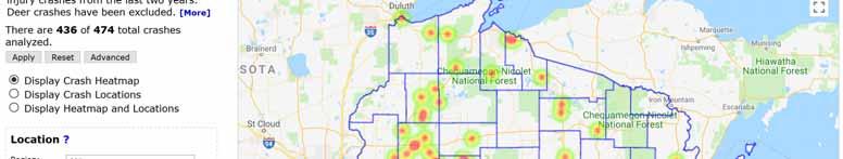
11 Traffic Safety Commission Guidelines

12 County Profiles


13
14 Where s the data??
15

16 Identify what you want here

17 Training Materials

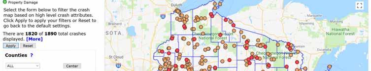
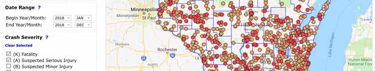
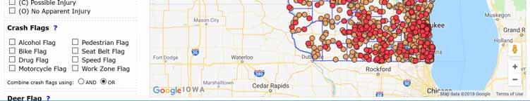
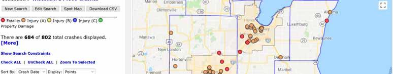
18 Public Search Interface: 2018 Fatality and Serious Injury Crashes.
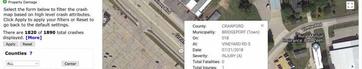
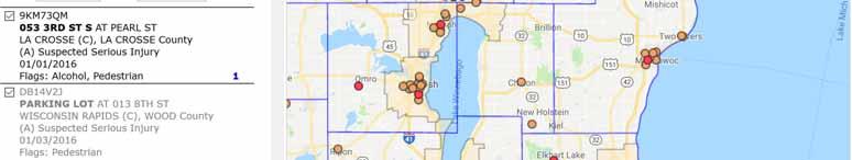
19 Search Interface: Satellite View.
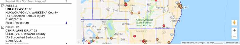
20 Advanced Interface: Eau Claire County Motorcycle Crashes, KABC Injury Levels, Last 5 Years. Crash Points (Left) vs. Density Plot (Right)
21 Advanced Interface: Route Based Search
22 Advanced Interface: Pedestrian crashes with MPA overlay.
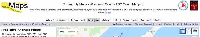
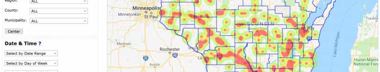
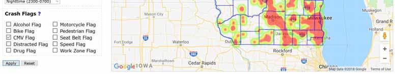
23 Analyze Interface: Statewide CMV Crashes for the Last 3 years, KAB Injury Levels
24 Area Jurisdiction Total (All Severities) Wisconsin-Statewide All Roads County Highway Columbia All Roads 7125 County Highway 1157 Intersections % % 209 3% 23 2% Speed/Aggressive % % % % Lane Departure % % % % Ped/Bike % 261 0% 49 1% 2 0% Impaired % % 344 5% 77 7% Distracted % % % % Unbelted % % % % Motorcycles % % 167 2% 50 4% Deer/Animal % % % % Large Trucks % % 489 7% 25 2% Older Drivers % % % 101 9% Teen Drivers % % % % Area Jurisdiction Severe (K&A Crashes) Wisconsin-Statewide All Roads County Highway 2819 Columbia County All Roads 228 County Highway 47 Intersections % % 64 28% 7 15% Speed/Aggressive % % 87 38% 26 55% Lane Departure % % % 36 77% Ped/Bike % 83 3% 8 4% 0 0% Impaired % % 57 25% 19 40% Distracted % % 63 28% 7 15% Unbelted % % 83 36% 16 34% Motorcycles % % 48 21% 13 28% Deer/Animal 365 2% 144 5% 10 4% 2 4% Large Trucks % 113 4% 23 10% 1 2% Older Drivers % % 34 15% 3 6% Teen Drivers % % 36 16% 10 21%

25 Why focus on roadway departure crashes Road Departure Resource FHWA Office of Safety Link to website 25
26 How can we reduce roadway departure crashes and crash severity? Keep the driver on the road improve signs, delineators, markings eliminate shoulder edge drop-offs rumble strips, geometric changes and other improvements educate drivers about the dangers of driving distractions
27 How can we reduce roadway departure crashes and crash severity? Reduce hazards for the driver who runs off the road remove or redesign fixed objects make objects breakaway protect with guard rail Where on the roadway should we focus these efforts? THE CLEAR ZONE
28 Clear Zone the total roadside border area, starting at the edge of the traveled way, available for safe use by errant vehicles. may consist of a shoulder, a recoverable slope, a non-recoverable slope, and/or a clear run-out area. Minimum width depends on traffic volume and speed and the roadside geometry. Clear zone is an unobstructed, relatively flat area beyond the edge of the pavement that allows a driver to stop safely or regain control of a vehicle that leaves the pavement Source:
29 29
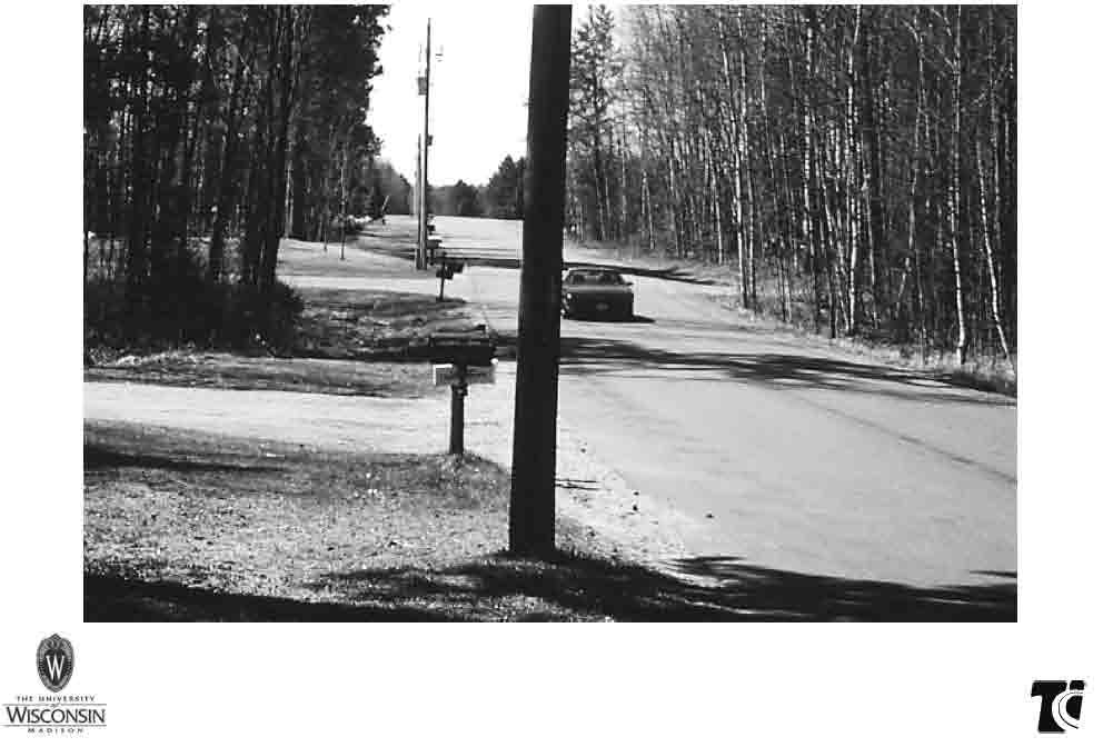
30
31 Clear Zone AASHTO - A Policy on Geometric Design of Highways and Streets(Green Book): For local roads and streets, a minimum clear zone of 7 to 10 feet is considered desirable on sections without curb. For collector streets without curbs, a 10-foot minimum clear zone is recommended. a clear zone of 10 ft. for low-speed rural collectors and rural local roads should be provided. Source : FHWA

 Vehicle trips per")
32 We will use the speed limit in our example (but speed limit does not necessarily equal design speed) Vehicle trips per day Pavement
33 Clear Zone Exercise 1: Based on the information presented in the previous slides, what would you recommend the clear zone be for the following road? Birch Ridge Road Town Road 22 Wide (2-11 ft. lanes ) Asphalt with 2 ft. gravel shoulders 800 vehicles per day (800 ADT) 55 mph speed limit


34 An additional clear zone consideration -- adjustment factor for the outside of curves
35 Clear Zone Exercise 2: Based on the information presented in the previous slides, what would you recommend the clear zone be for the following road? Red Pine Drive Town Road 22 Wide (2-11 ft. lanes ) Asphalt with 3 ft. gravel shoulders 400 vehicles per day (400 ADT) 45 mph speed limit 600 ft. radius curve

36 FHWA Clear Zones Resources 36


37 WHAT ARE POTENTIAL SAFETY ISSUES? Safety Issues: Narrow roadway Pavement markings Poor stopping sight distance Steep side slopes Gravel and stones on the roadway 2-37


38 WHAT ARE POTENTIAL SAFETY ISSUES? Safety Issues: Water on roadway No shoulder/edgeline 2-38


39 WHAT ARE POTENTIAL SAFETY ISSUES? Safety Issues: Trees in clear zone Limited sight distance Lack of signs and delineation 2-39


40 WHAT ARE POTENTIAL SAFETY ISSUES? Safety Issues: Bleeding pavement Lack of delineation 2-40


41 WHAT ARE POTENTIAL SAFETY ISSUES? Safety Issues: Fixed objects in clear zone Unrecoverable steep side slopes 2-41


42 WHAT ARE POTENTIAL SAFETY ISSUES? Safety Issue: Bridge structure is a fixed object 2-42


43 WHAT ARE POTENTIAL SAFETY ISSUES? Safety Issue: Pavement edge drop-off 2-43


44 Safety Issues: Faded pavement markings Concrete fixed object WHAT ARE POTENTIAL SAFETY ISSUES? 2-44


45 WHAT ARE POTENTIAL SAFETY ISSUES? Safety Issue: Deteriorated sign retroreflectivity 2-45


46 WHAT ARE POTENTIAL SAFETY ISSUES? Safety Issue: Fence blocks sidewalk path 2-46


47 Safety for All Road Users
48 TIC Resources One day training sessions around the state Road Maintenance Highway safety PASER and WISLR training Work zone traffic control Webinars on special topics from time to time PASER Manuals (Asphalt, Concrete, Gravel, Sealcoat over Gravel, Earth, Brick, Drainage) Work Zone and Flagger pocket guide books SAFER Manual, 23 fact sheets WISLR information links


49 TIC website epd.wisc.edu/tic
50 432 N. Lake Street Madison, Wisconsin Toll Free: (800) TIC TIC Website: Ben Jordan Andi Bill Steve Pudloski (608) (608) ) Transportation Information Center thanks its partners for their support and assistance
Engineering Countermeasures for Transportation Safety. Adam Larsen Safety Engineer Federal Highway Administration
 Engineering Countermeasures for Transportation Safety Adam Larsen Safety Engineer Federal Highway Administration 360-619-7751 Adam.Larsen@DOT.GOV Countermeasure Selection Resources Manual for Selecting
What Engineering Can Do for You! Low Cost Countermeasures for Transportation Safety
 What Engineering Can Do for You! Low Cost Countermeasures for Transportation Safety Adam Larsen Safety Engineer Federal Highway Administration 360-619-7751 Adam.Larsen@DOT.GOV Adam Larsen TTP Safety Engineer
Toward Zero Deaths. Regional SHSP Road Show Meeting. Virginia Strategic Highway Safety Plan. presented by
 Toward Zero Deaths Regional SHSP Road Show Meeting presented by Virginia Strategic Highway Safety Plan December 1, 2016 1 Welcome & Introductions Purpose of the Meeting Objectives & Key Outcomes Agenda»
Proven Safety Countermeasures. FHWA Office of Safety January 12, :00 p.m. to 2:00 p.m. Eastern Time
 Proven Safety Countermeasures FHWA Office of Safety January 12, 2012 1:00 p.m. to 2:00 p.m. Eastern Time Introduction and Background While States should still be considering the application of all of the
Geometric Design Tables
 Design Manual Chapter 5 - Roadway Design 5C - Geometric Design Criteria 5C-1 Geometric Design Tables A. General The following sections present two sets of design criteria tables - Preferred Roadway Elements
Lessons Learned from the Minnesota County Road Safety Plans. Richard Storm CH2M HILL
 Lessons Learned from the Minnesota County Road Safety Plans Richard Storm CH2M HILL May 21, 2014 Overview of the MN CRSP: Why Prepare Safety Plans for Local Systems? MAP-21: Requires states to address
Systemic Safety. Doug Bish Traffic Services Engineer Oregon Department of Transportation March 2016
 Systemic Safety Doug Bish Traffic Services Engineer Oregon Department of Transportation March 2016 Oregon averages 1700 fatal and serious injury crashes each year. Some of the more common crash types include:
Closing Plenary Session
 TRAFFIC SAFETY CONFERENCE Closing Plenary Session June 9, 2017 Las Colinas, TX Order of Report Out June 9, 2017 Las Colinas, TX Distracted Driving Prioritized Countermeasures Countermeasure 4a Systemically
FLORIDA STRATEGIC HIGHWAY SAFETY PLAN
 FLORIDA STRATEGIC HIGHWAY SAFETY PLAN 1 FLORIDA STRATEGIC HIGHWAY SAFETY PLAN Presenter: Joe Santos State Safety Engineer FDOT State Safety Office 2 Presentation 3/28/2017 3 FLORIDA STRATEGIC HIGHWAY SAFETY
How Might Connected Vehicles and Autonomous Vehicles Influence Geometric Design? October 10, 2017
 How Might Connected Vehicles and Autonomous Vehicles Influence Geometric Design? October 10, 2017 Overview Design Vehicle Design Driver Potential Geometric Impacts of Autonomous Vehicles Connected Vehicles
Road Side Design: When is a Barrier Required?
 Road Side Design: When is a Barrier Required? Jennifer Schmidt, Ph.D., P.E. University of Nebraska-Lincoln Department of Civil Engineering Guide Rail Safety Symposium Brampton, ON October 24, 2017 Research
Lane Departure. Key Facts
 Crash Certain types of vehicle crashes are more dangerous to drivers and other road users. The data show that crashes that involve lane departure and intersections are particularly perilous. Meanwhile,
DRIVING ZERO FATALITIES TO A REALITY ILLINOIS LOCAL SAFETY INITIATIVE
 DRIVING ZERO FATALITIES TO A REALITY ILLINOIS LOCAL SAFETY INITIATIVE Priscilla Tobias, PE State Safety Engineer Illinois Dept of Transportation Illinois Stats 102 Counties 145,000 Roadway Miles 900+ Fatalities
Road Safety Audit Course Participant Guidebook. August 22 & 23, Cleveland Avenue Columbus, Ohio
 Road Safety Audit Course Participant Guidebook August 22 & 23, 2017 Cleveland Avenue Columbus, Ohio 1 2 Table of Contents Executive Summary... 5 Cleveland Avenue City of Columbus... 6 Road Location Details...
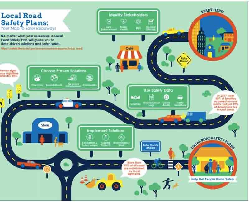
Local Road Safety Plans
 An Introduction to Local Road Safety Plans June 21, 2018 Today s Presenter Jerry Roche, P.E. Safety Analysis Program Manager FHWA Office of Safety Ames, IA 2 NACE Do-It-Yourself LRSP Pilot Six states,
INDEX. Geometric Design Guide for Canadian Roads INDEX
 Acceleration lane, see Lanes, Acceleration Access, 8.1 Access Management and Functional Classification 8.2 Access Management by Design Classification 8.3 Access Configuration 8.4 Building Set-Back Guidelines
Kentucky s Surface Transportation System
 Kentucky s Surface Transportation System ROAD AND BRIDGE CONDITIONS, TRAFFIC SAFETY, TRAVEL TRENDS, AND NEEDS MARCH 2018 PREPARED BY WWW.TRIPNET.ORG Founded in 1971, TRIP of Washington, DC, is a nonprofit
A Strategic Highway Safety Plan. a coordinated and informed approach to reducing highway fatalities and serious injuries on all public roads.
 Introduction A Strategic Highway Safety Plan is a coordinated and informed approach to reducing highway fatalities and serious injuries on all public roads. A Strategic Highway Safety Plan is Based on
Acknowledgements. Mr. David Nicol 3/23/2012. Daniel Camacho, P.E. Highway Engineer Federal Highway Administration Puerto Rico Division
 Daniel Camacho, P.E. Highway Engineer Federal Highway Administration Puerto Rico Division Acknowledgements Mr. David Nicol Director, FHWA Office of Safety FHWA Office of Safety http://safety.fhwa.dot.gov/provencountermeasures/
ENGINEERING AND PUBLIC WORKS. Transportation Improvements: Santa s Village Road (MR15) Public Meeting
 Public Meeting") ENGINEERING AND PUBLIC WORKS Transportation Improvements: Santa s Village Road (MR15) Public Meeting March 22, 2018 Agenda Welcome and Introductions Fred Jahn: Commissioner of Engineering and Public Works
ENGINEERING AND PUBLIC WORKS Transportation Improvements: Santa s Village Road (MR15) Public Meeting March 22, 2018 Agenda Welcome and Introductions Fred Jahn: Commissioner of Engineering and Public Works
KANSAS STRATEGIC HIGHWAY SAFETY PLAN
 KANSAS STRATEGIC HIGHWAY SAFETY PLAN 214 Annual Dashboard Report Preliminary Statewide Fatality Analysis The accident data herein, as of February 19, 215, reflect the reporting officer s observations and
Roadway Departure Focus State Initiative Roadside Safety Systems Inspection, Maintenance & Designers Mentoring Program
 Roadway Departure Focus State Initiative Roadside Safety Systems Inspection, Maintenance & Designers Mentoring Program Why worry about the roadside? 18,586 deaths per year in the USA Annual U.S. Fatalities
Where Did the Road Go? The Straight and Narrow about Curves
 Where Did the Road Go? The Straight and Narrow about Curves Renae Kuehl, SRF Consulting Group October 23, 2018 What is a County Roadway Safety Plan or CRSP?" CRSP Identifies priority location-specific
Driveway Design Criteria
 Design Manual Chapter 5 - Roadway Design 5L - Access Management 5L-4 Driveway Design Criteria A. General For efficient and safe operations, access drives and minor public street intersections can be improved
Clear Zone Conflicts in AASHTO Publications
 Clear Zone Conflicts in AASHTO Publications Dick Albin Washington State Department of Transportation Presented at the AASHTO Sub Committee on Design Meeting June 2007 Burlington, Vermont Clear Zone is
RURAL HIGHWAY SHOULDERS THAT ACCOMMODATE BICYCLE AND PEDESTRIAN USE (TxDOT Project ) June 7, Presented by: Karen Dixon, Ph.D., P.E.
 June 7, Presented by: Karen Dixon, Ph.D., P.E.") RURAL HIGHWAY SHOULDERS THAT ACCOMMODATE BICYCLE AND PEDESTRIAN USE (TxDOT Project 0-6840) June 7, 2016 Presented by: Karen Dixon, Ph.D., P.E., TTI Team: Kay Fitzpatrick, Raul Avelar, & Subasish Das Project
RURAL HIGHWAY SHOULDERS THAT ACCOMMODATE BICYCLE AND PEDESTRIAN USE (TxDOT Project 0-6840) June 7, 2016 Presented by: Karen Dixon, Ph.D., P.E., TTI Team: Kay Fitzpatrick, Raul Avelar, & Subasish Das Project
Institute of Transportation Engineers Safety Action Plan
 I Institute of Transportation Engineers Safety Action Plan 1. Introduction 2. Intersection Crashes 3. Keep Vehicles on the Road 4. Minimize Consequences When Vehicles Leave the Road 5. School Crossing
SECTION 14: LANDSCAPING AND BEAUTIFICATION
 SECTION 14: LANDSCAPING AND BEAUTIFICATION RULE 14.1 GENERAL PROVISIONS 14.1.1 The rules and guidelines contained in this section have been established to provide proper guidelines for the beautification
Safety Data Resources. Multi-Discipline Safety Planning Forum March 10 & 11, 2008 Gateway Center
 Safety Data Resources Multi-Discipline Safety Planning Forum March 10 & 11, 2008 Gateway Center Tom McDonald, PE Safety Circuit Rider Iowa LTAP Jack Latterell,, PE Safety Consultant FHWA Safety Engineer,
WYDOT DESIGN GUIDES. Guide for. NHS Arterial (Non-Interstate)
") WYDOT DESIGN GUIDES Guide for NHS Arterial (Non-Interstate) 2014 GUIDE FOR NATIONAL HIGHWAY SYSTEM (NHS) HIGHWAYS (NHS ARTERIALS, Non-Interstate) PRESERVATION REHABILITATION RECONSTRUCTION INTRODUCTION
WYDOT DESIGN GUIDES Guide for NHS Arterial (Non-Interstate) 2014 GUIDE FOR NATIONAL HIGHWAY SYSTEM (NHS) HIGHWAYS (NHS ARTERIALS, Non-Interstate) PRESERVATION REHABILITATION RECONSTRUCTION INTRODUCTION
SCHOOL CROSSING PROTECTION CRITERIA
 CITY OF MADISON TRAFFIC ENGINEERING SCHOOL CROSSING PROTECTION CRITERIA AUGUST 1990 Adopted as Policy on August 31, 1976, by Common Council by Amended Resolution #29,540 Amended on September 14, 1976,
SCHOOL CROSSING PROTECTION CRITERIA
 CITY OF MADISON TRAFFIC ENGINEERING SCHOOL CROSSING PROTECTION CRITERIA January 2016 Adopted as Policy on August 31, 1976, by Common Council by Amended Resolution #29,540 Amended on September 14, 1976,
WYDOT DESIGN GUIDES. Guide for. Non-NHS State Highways
 WYDOT DESIGN GUIDES Guide for Non-NHS State Highways 2014 GUIDE FOR Non-NATIONAL HIGHWAY SYSTEM (Non-NHS) STATE HIGHWAYS PRESERVATION REHABILITATION RECONSTRUCTION INTRODUCTION This Guide is directed to
TEXAS TRAFFIC SAFETY TASK FORCE. Jeff Moseley Texas Transportation Commission
 TEXAS TRAFFIC SAFETY TASK FORCE Jeff Moseley Texas Transportation Commission June 7, 2016 Fatalities and fatal crashes 2010 2015 4,000 3,500 3,417 3,407 3,536 3,533 3,000 3,061 3,067 2,782 2,803 3,037
GEOMETRIC DESIGN STANDARDS FOR NEW RESIDENTIAL SUBDIVISION STREETS TABLE 1A CG-6 CURB AND GUTTER SECTION
 TABLE 1A CG-6 CURB AND GUTTER SECTION HORIZONTAL AND VERTICAL CONTROLS CURB AND GUTTER ROADWAYS MAXIMUM 3:1 CUT OR FILL SLOPE CURVE DATA MIN. SIGHT DISTANCE PROJECTED TRAFFIC VOLUME (ADT) MIN. DESIGN SPEED
Chapter 4 On-Road Bikeways
 Chapter 4: 4-1.0 Introduction On-Road Bikeways This chapter provides guidelines to help select and design safe on-road bikeways. On-road bikeways include bicycle lanes, shared lanes, shoulders, and wide
STANLEY STREET December 19, 2017
 STANLEY STREET December 19, 2017 Welcome Mike Wiza, Mayor Scott Beduhn, Director of Public Works Agenda 1. Introduction 2. Existing Roadway Conditions 3. Current Alternative Improvements 4. Summary of
Pedestrian Safety: A Federal Perspective. Emmett McDevitt Transportation Safety Engineer September 28, 2010
 Pedestrian Safety: A Federal Perspective Emmett McDevitt Transportation Safety Engineer September 28, 2010 Pedestrian Fatalities by Year in US (1997-2009) 6,000 5,000 4,000 3,000 2,000 1,000 0 1997 1998
Welcome! Urban Work Zone Design. Training Course 0-1
 Welcome! Urban Work Zone Design Training Course 0-1 Instructor Instructor s Name Here 0-2 About This Course This material is based upon work supported by the Federal Highway Administration (FHWA) under
Roadside Safety Proven Countermeasures. Emmett McDevitt Transportation Safety Engineer Federal Highway Administration
 Roadside Safety Proven Countermeasures Emmett McDevitt Transportation Safety Engineer Federal Highway Administration Safety Statistics On average each year 43,000 + people die in traffic related crashes.
Shoulders. Chapter 4: chapter contents
 Chapter 4: Shoulders chapter contents Characteristics of Well-Maintained Shoulders 73 Optimal Timing/Conditions for Maintenance 73 Shoulder Maintenance Issues 74 Shoulder Maintenance Activities 75 Repairing
Off-road Trails. Guidance
 Off-road Trails Off-road trails are shared use paths located on an independent alignment that provide two-way travel for people walking, bicycling, and other non-motorized users. Trails specifically along
FHWA Resources for Pedestrian and Bicycle Professionals
 FHWA Resources for Pedestrian and Bicycle Professionals Charlie Zegeer, UNC Highway Safety Research Center/PBIC Libby Thomas, UNC Highway Safety Research Center Dan Nabors, Vanasse Hangen Brustlin (VHB)
Annual Progress Report from VDOT on the Effect of the Aging Population on State Agencies
 Annual Progress Report from VDOT on the Effect of the Aging Population on State Agencies HB 110 (2006 GA Session) Report to the Governor and General Assembly of Virginia Virginia Department of Transportation
Speed Management Action Plan
 Speed Management Action Plan National Selection Criteria Criteria Description Fatalities The number of fatalities resulting from speeding-related crashes. Percentage Compares total fatalities in each State
Now Let s Think Systemic
 Now Let s Think Systemic Remote Rural County Use of the Highway Safety Improvement Program TRINITY COUNTY DEPARTMENT OF TRANSPORTATION Richard Tippett Director MEET TRINITY COUNTY 3,208 square miles 13,786
Multimodal Design Guidance. October 23, 2018 ITE Fall Meeting
 Multimodal Design Guidance October 23, 2018 ITE Fall Meeting Introductions Jessica Wilson TDOT Multimodal Division Office of Multimodal Planning Program Supervisor Jessica.L.Wilson@tn.gov Ali Hangul TDOT
Designing for Pedestrians: An Engineering Symposium. Rutgers University March 21, 2013
 Designing for Pedestrians: An Engineering Symposium Rutgers University March 21, 2013 The Problem 2 Pedestrian Fatalities Pedestrian Fatalities by Year in US (1994-2010) 6000 5000 4000 3000 2000 1000 0
New Trends In Temporary Traffic Control (TTC) Spring Occupational Safety & Health Committee Conference Philadelphia, PA
 Spring Occupational Safety & Health Committee Conference Philadelphia, PA") New Trends In Temporary Traffic Control (TTC) Spring Occupational Safety & Health Committee Conference Philadelphia, PA Michael Kelly Work history - Fire service member of 30 years (retired at the rank
New Trends In Temporary Traffic Control (TTC) Spring Occupational Safety & Health Committee Conference Philadelphia, PA Michael Kelly Work history - Fire service member of 30 years (retired at the rank
Small Town & Rural Multimodal Networks
 Small Town & Rural Multimodal Networks Fred Young, PLA Andrea Clinkscales, AICP, PMP Alta Planning + Design Funding Partners Project Team Existing Design Guidance AASHTO Flexibility Guide 2004 AASHTO Bike
Access Management in the Vicinity of Intersections
 Access Management in the Vicinity of Intersections FHWA-SA-10-002 Technical Summary Photo: Ralph Bentley (used with permission) 0 Access Management is: The design, implementation and management of entry
Rebecca Szymkowski, P.E., PTOE Wisconsin Department of Transportation. ITE Midwestern District Annual Meeting June 30, 2015
 Rebecca Szymkowski, P.E., PTOE Wisconsin Department of Transportation ITE Midwestern District Annual Meeting June 30, 2015 Strategic Highway Safety Plan (SHSP) Roundabout Safety Analysis J-turn Experiences
Road Diets. Presented by: Cristine Gowland, P.E. LADOTD District 62 March 2, 2016
 Road Diets Presented by: Cristine Gowland, P.E. LADOTD District 62 March 2, 2016 FHWA s 9 Proven Safety Countermeasures 1. Safety Edge 2. Roundabouts 3. Corridor Access Management 4. Backplates with Retroreflective
11 CHECKLISTS Master Checklists All Stages CHECKLIST 1 FEASIBILITY STAGE AUDIT
 11 CHECKLISTS 11.1 Master Checklists All Stages CHECKLIST 1 FEASIBILITY STAGE AUDIT 1.1 General topics 1. Scope of project; function; traffic mix 2. Type and degree of access to property and developments
ROUNDABOUTS/TRAFFIC CIRCLES
 GENERAL 1. Description This standard identifies minimum requirements that shall be met for Roundabouts and Neighborhood Traffic Circles in the design and construction of elements for Arlington County Horizontal
TOWN OF PORTLAND, CONNECTICUT COMPLETE STREETS POLICY
 TOWN OF PORTLAND, CONNECTICUT COMPLETE STREETS POLICY I. VISION, GOALS & PRINCIPLES VISION To improve the streets of Portland making them safer and more accessible for all users including pedestrians,
Shared Use Path Design
 12B-2 Design Manual Chapter 12 - Sidewalks and Bicycle Facilities 12B - Bicycle Facilities Shared Use Path Design A. Accessible Shared Use Path Design 1. General: Applicable portions from the following
On Road Bikeways Part 1: Bicycle Lane Design
 On Road Bikeways Part 1: Bicycle Lane Design Presentation by: Nick Jackson Bill Schultheiss, P.E. September 04, 2012 FOLLOW THE CONVERSATION ON TWITTER Toole Design Group is live tweeting this webinar
CTDOT Pedestrian and Bicycle Safety Initiatives
 CTDOT Pedestrian and Bicycle Safety Initiatives 2017 Northeast Transportation Safety Conference Mark F. Carlino, P.E. Traffic Engineering Division Chief Bureau of Engineering and Construction Connecticut
KY s s RSA Evolution. Jo Anne Tingle, PE Kentucky Transportation Cabinet (KYTC) AASHTO TIG/FHWA RSA PEER Exchange Little Rock, AR - April 29, 2008
 AASHTO TIG/FHWA RSA PEER Exchange Little Rock, AR - April 29, 2008") KY s s RSA Evolution Jo Anne Tingle, PE Kentucky Transportation Cabinet (KYTC) AASHTO TIG/FHWA RSA PEER Exchange Little Rock, AR - April 29, 2008 Presentation Outline KY s s RSA History How we decided
KY s s RSA Evolution Jo Anne Tingle, PE Kentucky Transportation Cabinet (KYTC) AASHTO TIG/FHWA RSA PEER Exchange Little Rock, AR - April 29, 2008 Presentation Outline KY s s RSA History How we decided
REDUCING COLLISIONS AT HIGH CRASH LOCATIONS
 REDUCING COLLISIONS AT HIGH CRASH LOCATIONS Presented by Nazir Lalani P.E. Traffex Engineers Inc. N_lalani@hotmail.com ACCIDENTS AND SAFETY Why is safety important? Safety components Who is responsible?
PLACEMENT OF SIGNS RECOMMENDED PRACTICES SUB-SECTION
 Page 1 of 6 RECOMMENDED PRACTICES PART SECTION SUB-SECTION HIGHWAY SIGNS GENERAL General Proper positioning of signs is an important element in the overall control of traffic within a roadway network.
Alberta Infrastructure HIGHWAY GEOMETRIC DESIGN GUIDE AUGUST 1999
 Alberta Infrastructure HIGHWAY GEOMETRIC DESIGN GUIDE AUGUST 1999,1'(; A ACCELERATION Data on acceleration from stop D-29 Effects of grade D-35 Intersections D-97, D-99 Lanes D-97, F-5, F-7, F-15, F-21,
Road Safety Assessments. Lt. Bob McCurdy Williamson County Sheriff s s Office Marion, IL.
 Road Safety Assessments Lt. Bob McCurdy Williamson County Sheriff s s Office Marion, IL. Why Are We Here? 2005 US Traffic Fatalities = 43,443 1429 4329 1361 1616 1534 3504 1729 3543 Illinois Annual Fatallities
Part-time Shoulder Use Guide
 1 Part-time Shoulder Use Guide FHWA Guide AASHTO SCOD, Baltimore, MD June 2016 DOTs Face Increasing Challenges 2 Performance Based Practical Design 3 PBPD is a decision making approach that helps agencies
Keep Customers and Ourselves Safe. Mark Shelton, District Engineer. Tracker. Measures of Departmental Performance
 Keep Customers and Ourselves Safe Mark Shelton, District Engineer Tracker Measures of Departmental Performance Safety is a daily commitment for all MoDOT employees. From design and construction to operations
South Carolina Department of Transportation. Engineering Directive
 South Carolina Department of Transportation Engineering Directive Directive Number: ED-22 Effective: December 16, 2009 Subject: References: Purpose: This Directive Applies to: Considerations for Bicycle
References General Definitions
 Chapter 700 700.01 General 700.02 References 700.03 Definitions 700.04 Clear Zone 700.05 Hazards to Be Considered for Mitigation 700.06 Median Considerations 700.07 Other Features 700.08 Documentation
Crossing Islands and Raised Medians
 Countermeasure Strategies for Pedestrian Safety Crossing Islands and Raised Medians Demian Miller Tindale Oliver and Associates October 1, 2015 Today s Presentation Introduction and housekeeping Audio
Small Area Study U.S. Route 220 and VA Route 615 Intersection. Bath County, Virginia
 Small Area Study U.S. Route 220 and VA Route 615 Intersection Bath County, Virginia Prepared by the Central Shenandoah Planning District Commission Final Report February 2018 Table of Contents 1. INTRODUCTION...
October 2004 REVISIONS (2) SUPERELEVATION DEVELOPMENT 11.3(2)
 SUPERELEVATION DEVELOPMENT 11.3(2)") October 2004 REVISIONS (2) Chapter 11 HORIZONTAL ALIGNMENT SUPERELEVATION DEVELOPMENT 11.3(2) Chapter 12 VERTICAL ALIGNMENT VERTICAL CURVES PASSING SIGHT DISTANCE 12.5(2) VERTICAL CURVES STOPPING SIGHT
October 2004 REVISIONS (2) Chapter 11 HORIZONTAL ALIGNMENT SUPERELEVATION DEVELOPMENT 11.3(2) Chapter 12 VERTICAL ALIGNMENT VERTICAL CURVES PASSING SIGHT DISTANCE 12.5(2) VERTICAL CURVES STOPPING SIGHT
Work Zone Traffic Safety
 Work Zone Traffic Safety Summary The Hazard: death or serious injury from being struck by vehicles or equipment in work zones. Who is at risk: streets/highways, utilities and other public works department
Technical Memorandum SAFETY AND SECURITY. Prepared for: Prepared by:
 Technical Memorandum SAFETY AND SECURITY Prepared for: Prepared by: June 2013 TABLE OF CONTENTS 1. Introduction... 1 1.1 Background... 1 1.2 SAFETEA-LU... 1 1.3 MAP-21... 2 1.3.1 Highway Safety Improvement
Designing with the Railroad
 Designing with the Railroad 23 CFR 646.214 (b)(2) requires that crossings be evaluated when they are within limits or near terminus of Federally Funded project. Some rough numbers for planning: Active
Shenango Valley MPO. State Transportation Commission 2015 Twelve Year Program Development
 State Transportation Commission 2015 Twelve Year Program Development Regional results of the survey and public feedback from August thru November 2013 Shenango Valley MPO Version 01-2014 Mobility Concerns
Telling the Story of Safety
 Telling the Story of Safety Safety isn't expensive, its priceless. Road Safety Audits and Their Role In That Story Kirk Vinish Lummi Nation Planning Director Topics for Consideration 1. Facts relating
DOWNTOWN MIAMI PEDESTRIAN PRIORITY ZONE
 DOWNTOWN MIAMI PEDESTRIAN PRIORITY ZONE AUGUST 6, 2013 DOWNTOWN MIAMI BY THE NUMBERS more than 200,000 people live, work, and play here every day is home to more than 1,000 events each year hosts more
7 DESIGN CRITER RIA 7.1 Design Space Requirements
 7 DESIGN CRITERIA 7.1 Design Space Requirements The Nebraskaa Department of Roads (NDOR) provided examples of intersections where an approved guardrail end terminal and Approach Guardrail Transition (AGT)
(This page left intentionally blank)
") (This page left intentionally blank) 2011 Edition - Revision 1 Page 553 Section 5A.01 Function CHAPTER 5A. GENERAL 01 A low-volume road shall be defined for this Part of the Manual as follows: A. A low-volume
(This page left intentionally blank) 2011 Edition - Revision 1 Page 553 Section 5A.01 Function CHAPTER 5A. GENERAL 01 A low-volume road shall be defined for this Part of the Manual as follows: A. A low-volume
Table of Contents Kansas Highway Safety Improvement Program
 KANSAS Page 1 of 54 Table of Contents Table of Contents... 2 Disclaimer... 3 Executive Summary... 4 Introduction... 5 Program Structure... 5 Program Administration... 5 Program Methodology... 8 Project
Dr. Naveed Anwar Executive Director, AIT Consulting Affiliated Faculty, Structural Engineering Director, ACECOMS
 Dr. Naveed Anwar Executive Director, AIT Consulting Affiliated Faculty, Structural Engineering Director, ACECOMS Overview Highway Functions and Classifications Highway Design Components Design Control
THE FUTURE OF THE TxDOT ROADWAY DESIGN MANUAL
 THE FUTURE OF THE TXDOT ROADWAY DESIGN MANUAL Kenneth Mora, P.E. (Design Division) 10/10/2017 Table of contents 1 2 Reduction in FHWA design controlling criteria Innovative Intersection Guidance 3-7 8-42
VISION ZERO ACTION PLAN
 PALM BEACH Transportation Planning Agency VISION ZERO ACTION PLAN TPA Advisory Committee Meetings March 2019 PURPOSE Present the Data Analysis Key Findings and the Action Items from the Draft Action Plan
DEFINITIONS Activity Area - Advance Warning Area Advance Warning Sign Spacing Advisory Speed Approach Sight Distance Attended Work Space
 DEFINITIONS Activity Area - that part of a TTC zone activity area where the work actually takes place. It consists of the work space, traffic space and one or more buffer spaces. Advance Warning Area -
Reducing Fatalities and Serious Injuries on County Roads
 Reducing Fatalities and Serious Injuries on County Roads Brian C. Roberts, P.E. Executive Director National Association of County Engineers Washington, DC Housekeeping Please silence all mobile devices.
Keep Customers and Ourselves Safe. Mark Shelton, District Engineer. Tracker. Measures of Departmental Performance
 Keep Customers and Ourselves Safe Mark Shelton, District Engineer Tracker Measures of Departmental Performance Safety is a daily commitment for all MoDOT employees. From design and construction to operations
Chapter 5: Crossing the Street
 Chapter 5: Crossing the Street Whether walking or bicycling, a student s journey to school will more than likely require crossing one or more streets. Per the Safe Routes to School Guide, maintained by
Levels, and Road Uses
 Tahoe Unsurfaced Roads Workshop UC Cooperative Extension / SAF / TRPA / LWQCB / CGS / USFS Road Standards, Maintenance Levels, and Road Uses Gordon R. Keller, PE, GE Geotechnical Engineer grkeller@fs.fed.us
PEDESTRIAN ACCOMMODATIONS DPS 201 AT ROUNDABOUTS
 PEDESTRIAN ACCOMMODATIONS DPS 201 AT ROUNDABOUTS WHY THEY WORK FOR PEDESTRIANS IF DESIGNED CORRECTLY Separated sidewalks direct peds to crosswalks Splitter island Slow speed exit Truck apron Crosswalk
CHECKLIST 4: PRE-OPENING STAGE AUDIT
 CHECKLIST 4: PRE-OPENING STAGE AUDIT 4.1 General topics 4.1.1 Changes since previous audit; translation of design into practice General check: have any matters that have changed since a previous audit
NEIGHBORHOOD TRAFFIC CALMING POLICY
 NEIGHBORHOOD TRAFFIC CALMING POLICY I. PURPOSE The City of Kent continually strives to strengthen and protect its neighborhoods by improving the quality of life in residential areas. Traffic conditions
Walking Along the Road. Module 2
 Walking Along the Road Module 2 Learning Outcomes: 2-2 At the end of this module, you will be able to: Describe the operational and safety benefits of shoulders and sidewalks Select the appropriate design
HSIP Project Selection Criteria
 HSIP Project Selection Criteria The purpose of the Highway Safety Improvement Program (HSIP) is to reduce the number of fatal and injury crashes by targeting high crash locations and causes. Projects,
TRAFFIC CONTROL DEVICES FOR LOW VOLUME ROADS
 PART 5. TRAFFIC CONTROL DEVICES FOR LOW VOLUME ROADS TABLE OF CONTENTS Chapter 5A. GENERAL Page Section 5A.1 Function............................................................... 5A-1 5A.2 Application............................................................
This Chapter sets forth the minimum design, technical criteria and specifications to be used in the preparation of all roadway plans.
 4.1 GENERAL This Chapter sets forth the minimum design, technical criteria and specifications to be used in the preparation of all roadway plans. These Roadway Standards are for new construction and modification
Document Safer Roads Ottawa Program Workplan
 Document 2 2012 Safer Roads Ottawa Workplan The 2012 Safer Roads Ottawa (SROP) implementation plan includes: The production of a video to help launch the new SROP; The delivery of an annual year-long campaign-based
Appendix 3 Roadway and Bike/Ped Design Standards
 Appendix 3 Roadway and Bike/Ped Design Standards OTO Transportation Plan 2040 4/20/2017 Page A3-1 Adopted Standards The adopted OTO Design Standards and Major Thoroughfare Plan are contained herein.
INDOT Complete Streets Guideline & Policy
 INDOT Complete Streets Guideline & Policy INTRODUCTION The Complete Streets guidelines build upon multiple efforts and promote a multimodal transportation system that is integrated and sustains land use
Road Safety Facilities Implemented in Japan
 Road Safety Facilities Implemented in Japan 1 Road Safety Facilities 1.Guard Fence 2.Road Lighting 3.Other Road Safety Facilities 2 Road Safety Facilities 1.Guard Fence 2.Road Lighting 3.Other Road Safety
CHECKLIST 6: EXISTING ROADS: ROAD SAFETY AUDIT
 CHECKLIST 6: EXISTING ROADS: ROAD SAFETY AUDIT 6.1 Road alignment and cross-section 6.1.1 Visibility; sight distance Is sight distance adequate for the speed of traffic using the route? Is adequate sight