Base Information. 1. Project Title. SH 83 (Parker Road) Safety Improvements Bayou Gulch Rd. to El Paso County Northern Boarder (Highlighted red)
|
|
|
- Jade Cole
- 5 years ago
- Views:
Transcription
 Note: project includes environmental, design, right-of-way acquisition, utility relocations and")
1 Part 1 1. Project Title Base Information SH 83 Safety Improvements (Bayou Gulch Road to El Paso County) Note: project includes environmental, design, right-of-way acquisition, utility relocations and construction; however, we are only requesting federal funding for construction of to be identified top priority improvements within funding constraints. SH 83 (Parker Road) Safety Improvements Bayou Gulch Rd. to El Paso County Northern Boarder (Highlighted red) 2. Project Start/End points or Geographic Area Provide a map with submittal, as appropriate 3. Project Sponsor (entity that will construct/ complete and be financially responsible for the project) 4. Project Contact Person, Title, Phone Number, and Douglas County 5. Does this project touch CDOT Right-of-Way, involve a CDOT roadway, access RTD property, or request RTD involvement to operate service? Art Griffith, Capital Improvements Projects Manager, , AGriffit@douglas.co.us 4 Yes No If yes, provide applicable concurrence documentation with submittal
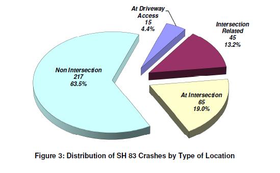
2 6. What planning document(s) identifies this project? Local plan: Other(s): Safety Assessment Report SH 83A MP El Paso/Douglas County Line North, Douglas County Department of Public Works (DiExSys, Jan. 2019) Douglas County 2030 Transportation Plan (Nov. 9, 2009), Widening pg. 47, Transit (Parker to Franktown) pg. 67, Bike pg. 70, Implementation pg SH83-86 Corridor Optimization Plan (Sept. 2004) 7. Identify the project s key elements. Provide link to document/s and referenced page number if possible, or provide documentation with submittal Rapid Transit Capacity (2040 FCRTP) Transit Other: Bicycle Facility (if possible) Pedestrian Facility Safety Improvements Roadway Capacity or Managed Lanes (2040 FCRTP) Roadway Operational Grade Separation Roadway Railway Bicycle Pedestrian Roadway Pavement Reconstruction/Rehab Bridge Replace/Reconstruct/Rehab Study Design Transportation Technology Components Other: Improvement priorities may include passing lanes, increase shoulder width, and intersections 8. Problem Statement What specific Metro Vision-related subregional problem/issue will the transportation project address? The SH 83 Safety Improvements (Bayou Gulch Road to El Paso County) project is targeted to address each of the Metro Vision themes of in manner consistent with the principles of thinking regionally and working collaboratively to address imperative needs in realizing the aspirational targets for the region. SH 83 is a unique transportation facility within the region and as a vital connection to adjoining destinations. As a regional arterial and also serving as a rural highway, it connects multiple communities, provides access to natural resources and agricultural areas of southeast Douglas County, and allows rural DRCOG region residents with timely access to health care, emergency services, schools, businesses, and the opportunities of the regional economy. This highway is also the only other significant route parallel to I-25, connecting Douglas and El Paso counties; and the two largest MPO s in Colorado. Maintaining a safe, efficient, and all-weather operation is critical to the resiliency of the region s transportation system and the health of its residents, to preserve a high quality of life. This project will construct identified high priority projects that will address safety and resiliency needs in the SH 83 corridor. Improvements will be identified through a corridor planning process being funded locally independent of this application. Douglas County has completed an initial assessment of the corridor to quantify the significant safety issues (prepared by DiExSys, January 2019 full report available upon request). Beginning in 2019, Douglas County will continue to fund additional analysis to identify specific improvements for safety and other measures of performance of this critical transportation facility within the limits of the construction budget. They have requested and obtained CDOT concurrence on the purpose and need for the project. 5
3 The safety analysis preliminarily identified multiple locations and strategies where constructed improvements would provide a high benefit to cost return on investment. It is anticipated that the Total Project Cost shown in Section A.1 below could provide significant performance enhancement for the corridor in safety and resiliency. The efficient and responsible investment of resources in addressing safety problems presents challenges within the limitations of available budgets and the aspirations captured by CDOT s Moving Towards Zero Deaths initiative. Going even further, it is Douglas County s objective to maximize crash reduction within the limitations of available budgets by making road safety improvements at locations where it provides the greatest crash reduction and meets or exceeds HSIP required cost-benefit thresholds. SH 83 is one of the top three most traveled north-south corridor in Douglas County. Travelers using the corridor navigate a facility that lacks safety features including passing lanes, many intersections without turn lanes, and inadequate or non-existent shoulders abutting non-recoverable slopes. The corridor also traverses some of the highest and windiest terrain in the southern front range and driving in winter weather events is challenged by blowing and drifting snow, lack of delineators or shoulder rumble strips, and none of the traveler aids including remote weather information stations (RWIS), cameras, or message signs that could make travel smarter. There are significant populations of elk and deer that cross the highway, especially at dusk or dawn to water in Cherry Creek or other smaller drainages that generally parallel the route. The Safety Analysis recently completed by Douglas County indicates that this corridor has a significant number of crashes every year and this number has grown from 54 in 2012 to 90 in Fatalities in this period were 11 people killed. Ten of those were in non-intersection locations which indicates the dangerous conditions of the roadway itself. This problem will be addressed through a mix of corridor wide and site-specific improvement identified through a corridor study and programmed within the requested construction budget. When considering safety improvements, the supplemental analysis will evaluate resiliency, system preservation, mobility, and other measures to identify short term investments appropriate for the budget of this request and longer-term investments that will require future funding. For example, our project team will evaluate/consider utilizing innovative long-term solutions such as Swedish 2+1 as a pilot project, as depicted later in this application. 9. Define the scope and specific elements of the project. The scope of improvements and specific elements are being identified in a planning phase. This phase will conclude with the selection of cost effective and valued engineering solutions for final design and implementation. The planning phase will determine which segments of SH83 will be improved to maximize available funding in the construction of these safety improvements. Strategies to be considered include passing lane sections, intersection improvements, turn lanes, and clear zone protections in spot locations where crashes are occurring. Corridor wide strategies including delineators, rumble strips, driver alerts and conflict warning systems. Replacement of guardrail with cable rail and other improvements to mitigate blowing and drifting snow may also be determined to have positive benefit cost ratios for improving safety. 10. What is the status of the proposed project? advance the Safety Assessment Report for US 83, El Paso-Douglas County Line North to the selelection of options available to continue the completion of the NEPA enviromental clearance document and preparing preliminary plans / final construction documents Advance the project to constrcution completion. 11. Would a smaller DRCOG-allocated funding amount than requested be acceptable, while maintaining the original intent of the project? Yes No 6
4 If yes, define smaller meaningful limits, size, service level, phases, or scopes, along with the cost for each. Though the analysis already completed by the applicant, the Total Project Cost was determined to be the minimum investment necessary to affect any meaningful performance improvement in this 23.8-mile-long corridor; however, the applicant would be willing to consider accepting $5.5M in lieu of $6.0M. A. Project Financial Information and Funding Request 1. Total Project Cost $12,000, Total amount of DRCOG Subregional Share Funding Request $6,000,000 50% of total project cost 3. Outside Funding Partners (other than DRCOG Subregional Share funds) List each funding partner and contribution amount. $$ Contribution Amount % of Contribution to Overall Total Project Cost Applicant Contribution 3,000,000 25% CDOT Funding Request 3,000,000 25% Total amount of funding provided by other funding partners (private, local, state, Regional, or federal) $ $ $ $ $6,000,000 Funding Breakdown (year by year)* *The proposed funding plan is not guaranteed if the project is selected for funding. While DRCOG will do everything it can to accommodate the applicants request, final funding will be assigned at DRCOG s discretion within fiscal constraint. Funding amounts must be provided in year of expenditure dollars using an inflation factor of 3% per year from FY 2020 FY 2021 FY 2022 FY 2023 Total Federal Funds $0 $0 $3,000,000 $3,000,000 $6,000,000 State Funds $0 $0 $3,000,000 $ 0 $3,000,000 Local Funds $0 $0 $3,000,000 $0 $3,000,000 Total Funding $0 $0 $9,000,000 $3,000,000 $12,000, Phase to be Initiated Choose from Design, ENV, Construction ROW, CON, Study, Service, Equip. Purchase, Other 5. By checking this box, the applicant s Chief Elected Official (Mayor or County Commission Chair) or City/County Manager for local governments or Agency Director or equivalent for others, has certified it allows this project request to be submitted for DRCOG-allocated funding and will follow all DRCOG policies and state and federal regulations when completing this project, if funded. 7
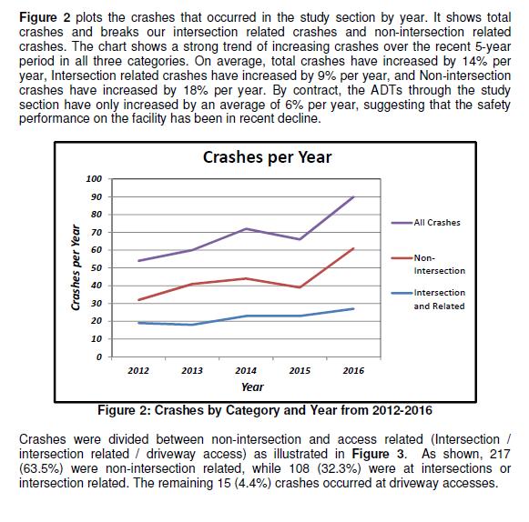
5 Part 2 Evaluation Criteria, Questions, and Scoring A. Subregional significance of proposed project WEIGHT 40% Provide qualitative and quantitative (derived from Part 3 of the application) responses to the following questions on the subregional significance of the proposed project. 1. Why is this project important to your subregion? SH 83 is one of the top three most north-south traveled corridors in Douglas County with 2018 Average Daily Traffic (ADT) exceeding 17, volumes are projected to range from 14,000 to 28,000 ADT throughout the corridor. On average, over the last five years total crashes have increased by 14% per year, intersection related crashes have increased by 9% per year, and non-intersection crashes have increased by 18% per year. Continued growth in the region is expected to increase traffic volumes and the current trend of increasing crashes. Improvement are needed to improve the safety of this heavily traveled corridor. Improvements on SH 83 will also provide a reliability and redundancy in the transportation system for commuters and residents within Douglas County and regionally to and from Arapahoe County, El Paso County, and Elbert County. Additionally, SH83 serves as a secondary alternative route to I-25 between the Denver Metro area and Colorado Springs. This redundancy will improve reliability for the workforce and users. These improvements will also resolve many safety issues found in the current planning 2. Does the proposed project cross and/or benefit multiple municipalities? If yes, which ones and how? SH 83 is the primary access route for several municipalities in Douglas County and serves as a secondary travel route between the Denver Metropolitan Area and municipalities in Douglas County, Elbert County, and El Paso County. SH83 benefits and crosses directly through Franktown, the Town of Parker, and the Town of Castle Rock s eastern boundary at Castle Oaks Drive. SH83 further benefits several municipalities by providing secondary access from southern Colorado and City of Colorado Springs to the City and County Denver, City of Centennial, City of Aurora, Town of Elizabeth through the junction of SH86, Town of Monument, by providing additional options and an alternative route to I-25. The SH83 project improves safety and significantly increases the reliability of the corridor for residents in these municipalities. It also provides a reliable local alternative to I-25 ensuring access for area residents during incidents on I-25. The project further benefits these municipalities by connecting these communities to open space and recreational trails along SH83. Improved shoulders can also provide bicyclists a safer connection to regional trails within the corridor. 3. Does the proposed project cross and/or benefit another subregion(s)? If yes, which ones and how? SH 83 provides significant benefits to the Douglas County, Arapahoe County, and City and County of Denver subregions. SH 83 additionally provides benefits to El Paso County and Elbert County as part of a larger transportation network. SH 83 serves as a major north-south corridor for the subregions of Douglas County and Arapahoe County, and is a secondary route to the City and County of Denver to the north and El Paso County to the south. SH 83 also serves as a primary collector for Elbert County to access the Denver Metro area. Frequent crashes create congestion and 8

6 unpredictable travel times in the subregions. The planned improvements will improve safety and provide a reliable route that supports the subregional transportation network. SH 83 also provides an alternative subregional route to I-25 for improved incident management within Douglas, Arapahoe, and El Paso County. All three subregions will greatly benefit by having SH 83 improved to better accommodate rerouted traffic and incidents on the I-25 corridor. 4. How will the proposed project address the specific transportation problem described in the Problem Statement (as submitted in Part 1, #8)? The SH 83 Safety Project is needed to address the significant safety issues on this 23.8 mile long corridor and to provide a more resilient regional network. Douglas County has already funded a preliminary safety assessment of the corridor to confirm the need and to identify a range of likely strategies to meet these safety needs. The assessment provided a quantitative analysis of crash data from 2012 through The following information related to safety is excerpted from the January 2019 report. SH 83 is classified as a Rural Principal Arterial throughout the study section. It is primarily a 2-lane undivided facility except near some of the more prominent intersections, where turn lanes and divided median have been provided, and through a short section from MP to 45.55, where additional outer lanes have been provided for Port-of-Entry processing. Table 1 summarizes the locations of the sections where SH 83 is not a 2-lane undivided highway. The travel lanes are 12 feet wide. Paved shoulders are typically 2 feet or less in width except in widened areas for guardrail and intersections. There do not appear to be either shoulder or centerline rumble strips anywhere within the study limits. The Average Annual Daily Traffic (AADT) varies considerably through the corridor and has been tallied in Table 2 below. The posted speed limit is 65 mph south of Franktown with one 50 mph (when flashing) school speed zone near MP 38. The speed limit north of Franktown is 55 mph. Both directions step down to 35 mph entering Franktown. For detailed information on speed zone signing see Table 3 in the report. 9

7 Table from Safety Assessment Report 10
8 11
9 12

10 The concept of level of service uses quantitative measures and qualitative description that characterize safety of a roadway segment in reference to its expected frequency and severity. The degree of deviation from the norm can be stratified to represent specific levels of safety. The various LOSS are thus defined: LOSS I - Indicates low potential for crash reduction LOSS II - Indicates low to moderate potential for crash reduction LOSS III - Indicates moderate to high potential for crash reduction LOSS IV - Indicates high potential for crash reduction The results of the safety assessment confirm that the corridor exhibits a significantly high frequency of crashes and that this number is trending higher at an increasing pace. The assessment also concludes that there is opportunity for significant potential crash reduction through modest investments. Potential investments were evaluated for benefit and cost within the assessment. Corridor segment and intersection options were selected in the table below to maximize the cost benefit ratios. 13
11 Segment Location MP MP MP MP MP MP MP MP MP MP Intersection Location Gillian Avenue Russellville Road (North) Park Drive Palmer Divide Road Russellville Road (South) Lake Gulch Road Russellville Road (North) Hwy 86 Improvement Convert to Swedish 2+1 Lane Section with Cable Barrier Widen to add TWLTL and 8' Shoulders with Rumble Strips Cable Rail - Spot Location (MP ) Cable Rail - Full Segment Cable Rail - Full Segment Cable Rail - Full Segment Cable Rail - Spot Location (MP ) *Centerline Rumble Strips (W/O Widening) Centerline Rumble Strips (ONLY) Centerline and Shoulder Rumble Strips (W/O Widening) Improvement Southbound Left Turn Lane Widening to 8' Shoulders 600' N and S of Intersection Southbound Left Turn Lane Conflict Warning System Conflict Warning System Conflict Warning System Conflict Warning System Fully Protected Left Turns, Northbound and Southbound Cost of Implementation Service Life Benefit $ 2,960,000 $ 10,419, $ 1,925,000 $ 6,949, B/C Category Select 4. Swedish Widening $ 125,000 $ 673, Cable x $ 850,000 $ 569, Cable x $ 900,000 $ 891, Cable x $ 592,000 $ 787, Cable x $ 180,000 $ 3,155, Cable x $ 6,600 $ 6, $ 11,000 $ 863, $ 25,800 $ 573, Cost of Implementation Service Life Benefit 1b. Rumble (Center) 1b. Rumble (Center) 1a. Rumble (Both) B/C Category Select $ 315,000 $ 2,305, Auxiliary x $ 170,000 $ 1,519, Auxiliary x $ 220,500 $ 855, Auxiliary x $ 20,000 $ 1,586, CWS x $ 20,000 $ 114, CWS x $ 20,000 $ 100, CWS x $ 20,000 $ 718, CWS x $ 5,000 $ 1,345, Signal Mod x x x x x x Segment Selection Cost: $7,575,400 Service Life Benefit: $24,888,396 B/C= 3.3 Intersection Selection Cost: $790,500 Service Life Benefit: $8,545,890 B/C= 10.8 Total Selection Cost: $8,365,900 Service Life Benefit: $33,434,286 B/C= 4. 14

12 One of the strategies considered in the evaluation is the Swedish 2+1 roadway as illustrated below. This innovative approach proves effective in providing crash reduction. SH 83 could be used as a pilot project for similar two-lane roadways through rolling terrain where safety needs are identified. Some of the crash characteristics in the segment analyzed are among those that have been shown to respond well to the introduction of the Swedish 2+1 cross section. This configuration consists of three traffic lanes, one for each direction of travel, plus a third lane, which alternately provides an additional lane for one direction of travel and then the other, with the opposing lanes of traffic are separated by cable rail. Observational before and after studies conducted in Sweden over the last 20 years or so showed that 75% crash reduction in fatalities and 50% reduction in injuries can be expected. In addition to reducing head-on and sideswipe-opposite crashes Swedish 2+1 Section with Barrier is also effective in reducing severity of the roadway departure crashes such as overturning and fixed object collisions. Since this segment of SH 83 exhibits a higher than expected frequency of crashes involving bodily injury, this may be an effective location to use the Swedish 2+1 configuration. While such an improvement is beyond the scope of the current request, it will be considered in the planning phase being continued by Douglas County in Such long-term solutions will be considered and identified as part of a program for short and long-term implementation. Both short and long-term improvements will also be evaluated for enhancing the reliability of SH 83 as part of a resilient transportation network. Manu of the considered safety improvements provide a reliability benefit as well including shoulder improvements. Additional short-term improvements that may provide reliability benefit include: Blowing and drifting snow mitigation Driver information systems including RWIS, speed indication signs ahead of sharp curves, and animal crossings Web accessible cameras for inclusion in CDOT s COTrip traveler information website Variable message signs coordinated with I-25 systems to alert drivers to alternate routes during incidents While this request is for an initial project that will provide immediate benefit with a moderate investment, Douglas County is leading the way to identify long-term, regionally-beneficial solutions by undertaking a more comprehensive planning phase prior to project identification, design, and this construction request. 15
13 5. One foundation of a sustainable and resilient economy is physical infrastructure and transportation. How will the completed project allow people and businesses to thrive and prosper? Enhancing the safety and reliability of this critical link in the regional transportation system will increase opportunities for people and business to share in a vibrant economy. In its current condition, the SH 83 corridor is unreliable at best and dangerous at times. Frequent crashes in a constrained corridor cause road closures without available detours. Weather events, car vs animal crashes, and limited opportunities to pass safely create risk and delay that inhibits business opportunities. For smaller communities like Franktown, SH 83 is both a main street for local business and a critical connection to regional commerce, health care, schools, and employment. The vast open space amenities available in this part of the region are a tremendous asset for attracting employers and provide a benefit to employees quality of life. An improved SH 83 provides safe and reliable access and allows for an increase in public health and recreation benefits. These improvements will positively impact the business sectors of Castle Rock, Parker, Franktown, Denver, Centennial, Arapahoe County, and their connectivity to the economic opportunities in El Paso County. 6. How will connectivity to different travel modes be improved by the proposed project? Safety and resiliency improvements on SH 83 will benefit multiple travel modes within the corridor and provide connectivity to the trails systems adjacent to the corridor. The planning phase will identify beneficial and costeffective safety improvements for the corridor that are likely to include construction of shoulders where none currently exist. Any shoulders will provide a more comfortable location for bicyclists to ride, and shoulders also provide space to pull over in emergency and other benefits. RTD s P route currently comes to just north of the project, which could benefit from improved first/last mile connectivity. 7. Describe funding and/or project partnerships (other subregions, regional agencies, municipalities, private, etc.) established in association with this project. Project funding will be a partnership from Federal Highway Administration (50%), Colorado Department of Transportation (25%) and Douglas County (25%) This pertains to construction only. Douglas County anticipates incurring additional cost during the design phase which are not part of this grant application request. B. DRCOG Board-approved Metro Vision TIP Focus Areas WEIGHT 30% Provide qualitative and quantitative (derived from Part 3 of the application) responses to the following questions on how the proposed project addresses the three DRCOG Board-approved Focus Areas (in bold). 1. Describe how the project will improve mobility infrastructure and services for vulnerable populations (including improved transportation access to health services). This project will improve safety for school children attending schools located on the roadway including Cherry Valley Elementary, Franktown Elementary, Trinity Lutheran School and Ponderosa High School on the north end. An improved SH 83 will also improve access to health care providers in the Parker and Denver Metro areas for residents of southeast Douglas County, and Elbert County. This corridor is the primary transportation artery for a significant geography and growing population. Alternative routes are few and far between when SH 83 is closed due to accident or weather event. 2. Describe how the project will increase reliability of existing multimodal transportation network. A reliable and safe SH 83 complements and supports the much larger investment of I-25 as part of a resilient transportation network. Inter-regional bus service such as Bustang service between El Paso County and the Denver Metro area rely on a functional connection. SH 83 provides the only realistic alternative should incidents 16

14 on I-25 force a closure. Emergency response for natural disasters and the large scale management of such events also depend on functioning parallel routes. Besides I-25, SH 83 is the only continous connection from the Denver Metro area to the Pikes Peak region. 3. Describe how the project will improve transportation safety and security. One of the main project goals is to improve user safety and regional reliability. This will occur through improved cross sections, safety devices, and roadside enhancements. The following graphic, Figure 7 from the safety study, shows the current crash rates on the corridor compared to the national average. This project will seek to improve, at the very least, the locations where the roadway sees LOSS-IV rates. 17
15 C. Consistency & Contributions to Transportation-focused Metro Vision Objectives WEIGHT 15% Provide qualitative and quantitative responses (derived from Part 3 of the application) to the following items on how the proposed project contributes to Transportation-focused Objectives (in bold) in the adopted Metro Vision plan. Refer to the expanded Metro Vision Objective by clicking on links. MV objective 2 Contain urban development in locations designated for urban growth and services. 1. Will this project help focus and facilitate future growth in locations where urban-level infrastructure already exists or areas where plans for infrastructure and service expansion are in place? Yes No This project is not a capacity increasing project. By providing a safer and more reliable connection to the existing urban area of Parker, an improved SH 83 serves to enhance its role as an area hub and attraction. MV objective 3 Increase housing and employment in urban centers. 2. Will this project help establish a network of clear and direct multimodal connections within and between urban centers, or other key destinations? Yes No A safer and more reliable SH 83 enhances the connections between the urban centers of Parker and the larger Denver Metro Area to the open spaces and agricultural areas of southeast Douglas County. It also provides a very direct connection to El Paso county and the urban area and economic hub of the Pikes Peak region east of I- 25. Without SH 83 this portion of the region is underserved with primiary routes for transportion. MV objective 4 Improve or expand the region s multimodal transportation system, services, and connections. 3. Will this project help increase mobility choices within and beyond your subregion for people, goods, or services? Yes No Increasing safety and dependability of the SH 83 corridor will improve the interconnections of the multimodal transportation system within and beyond the region for people and freight. SH 83 along with SH85 and I25 are the only north south entrances into the southern portion of the Denver Metro area. Maintaining these options in a safe and efficient manner will expand and improve the regions multimodal transportation system. In addition, the September SH83-86 Corridor Optimization Plan outlines a business plan that has been used to encourage integrated land use and transportation planning among state and regional agencies, local governments, and the development community. MV objective 6a Improve air quality and reduce greenhouse gas emissions. 4. Will this project help reduce ground-level ozone, greenhouse gas emissions, carbon monoxide, particulate matter, or other air pollutants? Yes No A more reliable SH 83 will reduce the congestion cause by frequent accidents and the resulting full or partial closures. Many segments of the corridor offer little room to bypass traffic around accidents. Detour routes are long and cause additional VMT. Improved operations of SH 83 could reduce congestion on I-25 during peak demand by providing transportation network choices. 18

16 MV objective 7b Connect people to natural resource or recreational areas. 5. Will this project help complete missing links in the regional trail and greenways network or improve other multimodal connections that increase accessibility to our region s open space assets? There are numerous open space and recreational areas located on this stretch of road including: Castlewood Canyon State Park Hidden Mesa Open Space Lincoln Mountain Open Space Colorado Front Range Trail Palmer Ranch Divide Trail Multiple Reservoirs Entrance to Black Forest Multiple Open Space Ranches Some of the largest open space resources in the area are accessed via SH 83. Safety improvements to the roadway will improve multimodal access to these resources. Yes No Bayou Gulch Open Space and Connector Trail: The connector that runs west under SH 83 to the Cherry Creek Regional Trail is open to pedestrians, equestrians, and bicyclists. The peripheral trail may be closed occasionally to accommodate equestrian events associated with the Colorado Horse Park. Horse jumps and pathways leading to the jumps are not open to the public as they are privately owned by the Colorado Horse Park. Hidden Mesa Open Space Trail (located 1-mile north of SH 86): Of the over 1300 accessible acres, approximately over 30,000 access the open space and approximately 21,000 users access the open space from SH83. There is currently no west bound turn left lane from northbound SH83. Douglas County s Hidden Mesa Open Space opened seven miles of trails and a trail head on June 10, This provides access to the Cherry Creek Trail which bisects the property. The trailhead is located one mile north of 19
.")

17 Franktown on the west side of SH 83 (Parker Road) for hikers, bicyclists, and horseback riders. Travel one mile north of Franktown on Parker Road (SH 83). It is on the west/left side with a large Hidden Mesa Open Space sign. Lincoln Mountain Open Space Of the over 876 accessible acres, approximately 13,000 users access the amenities from SH83. There is currently no west bound turn left lane from northbound SH83. 20

18 The 876-acre Lincoln Mountain Open Space is located along the upper reaches of West Cherry Creek with meadows and rolling grasslands that are backed up by forested rocky cliffs and the taller mesa of Lincoln Mountain portion of land operates as a working cattle and hay ranch. It has a high value wildlife habitat and contains riparian habitat for the federally threatened Preble s Meadow Jumping Mouse. Miles of trails are open to the public for hiking, horseback and mountain biking. MV objective 10 Increase access to amenities that support healthy, active choices. 6. Will this project expand opportunities for residents to lead healthy and active lifestyles? Yes No By enhancing the accessibility of the areas large open space resources, this project would also provide access to activities that support healthy and active lifestyles. Safety investments are likely to include shoulder improvements that could provide additional bicycling opportunities and access to additional trail systems including the Colorado Front Range Trail. The SH 83 corridor also traverses much of the county s agricultural land including access to hiking, equestrian, and other outdoor activities. MV objective 13 Improve access to opportunity. 7. Will this project help reduce critical health, education, income, and opportunity disparities by promoting reliable transportation connections to key destinations and other amenities? Yes No The SH 83 corridor traverses a portion of the county with almost 20% of the population over age 65 living in a rural portion of the DRCOG planning area. All the residents of these areas require reliable transportation facilities to access health care, emergency services, grocery and other retail, education, and the other opportunities provided in urban centers. Smaller communities like Franktown rely on the connection provided by SH 83 for services and freight deliveries. 21
19 MV objective 14 Improve the region s competitive position. 8. Will this project help support and contribute to the growth of the subregion s economic health and vitality? Describe, including supporting quantitative analysis Yes No Improving the safety and resiliency of SH 83 will positively impact the health and vitality of the subregion by providing: Stronger and safer connection between the communities within this segment of the corridor and those to the north and south to better connect these smaller economies into a larger, more vibrant whole. Better and safer access to the natural resource areas and amenities that are a significant asset for attracting business and jobs More reliable travel for area residents accessing the schools, businesses, and health care providers Providing an all weather alternative during incidents on I-25 which increases reliability for commuters, tourism, and freight mobility. D. Project Leveraging WEIGHT 15% 9. What percent of outside funding sources (non-drcog-allocated Subregional Share funding) does this project have? 50% 60%+ outside funding sources... High 30-59%... Medium 29% and below... Low 22
20 Part 3 A. Transit Use Project Data Worksheet Calculations and Estimates (Complete all subsections applicable to the project) 1. Current ridership weekday boardings 0 2. Population and Employment Year Population within 1 mile Employment within 1 mile Total Pop and Employ within 1 mile , , ,094 1,809 8,903 Transit Use Calculations 3. Enter estimated additional daily transit boardings after project is completed. (Using 50% growth above year of opening for 2040 value, unless justified) Provide supporting documentation as part of application submittal 4. Enter number of the additional transit boardings (from #3 above) that were previously using a different transit route. (Example: {#3 X 25%} or other percent, if justified) 5. Enter number of the new transit boardings (from #3 above) that were previously using other non-sov modes (walk, bicycle, HOV, etc.) (Example: {#3 X 25%} or other percent, if justified) Year of Opening 2040 Weekday Estimate = Number of SOV one-way trips reduced per day (#3 #4 #5) Enter the value of {#6 x 9 miles}. (= the VMT reduced per day) (Values other than the default 9 miles must be justified by sponsor; e.g., 15 miles for regional service or 6 miles for local service) = Number of pounds GHG emissions reduced (#7 x 0.95 lbs.) If values would be distinctly greater for weekends, describe the magnitude of difference: 10. If different values other than the suggested are used, please explain here: B. Bicycle Use 1. Current weekday bicyclists 3 2. Population and Employment Year Population within 1 mile Employment within 1 mile Total Pop and Employ within 1 mile ,475 8,547 19, ,702 14,622 27,324 23
21 Bicycle Use Calculations 3. Enter estimated additional weekday one-way bicycle trips on the facility after project is completed. 4. Enter number of the bicycle trips (in #3 above) that will be diverting from a different bicycling route. (Example: {#3 X 50%} or other percent, if justified) Year of Opening 2040 Weekday Estimate = Initial number of new bicycle trips from project (#3 #4) Enter number of the new trips produced (from #5 above) that are replacing an SOV trip. (Example: {#5 X 30%} (or other percent, if justified) = Number of SOV trips reduced per day (#5 - #6) Enter the value of {#7 x 2 miles}. (= the VMT reduced per day) (Values other than 2 miles must be justified by sponsor) = Number of pounds GHG emissions reduced (#8 x 0.95 lbs.) If values would be distinctly greater for weekends, describe the magnitude of difference: 11. If different values other than the suggested are used, please explain here: C. Pedestrian Use 1. Current weekday pedestrians (include users of all non-pedaled devices) 0 2. Population and Employment Year Population within 1 mile Employment within 1 mile Total Pop and Employ within 1 mile , , ,094 1,809 8,903 Pedestrian Use Calculations 3. Enter estimated additional weekday pedestrian one-way trips on the facility after project is completed 4. Enter number of the new pedestrian trips (in #3 above) that will be diverting from a different walking route (Example: {#3 X 50%} or other percent, if justified) Year of Opening 2040 Weekday Estimate = Number of new trips from project (#3 #4) Enter number of the new trips produced (from #5 above) that are replacing an SOV trip. (Example: {#5 X 30%} or other percent, if justified) = Number of SOV trips reduced per day (#5 - #6)
22 12. Enter the value of {#7 x.4 miles}. (= the VMT reduced per day) (Values other than.4 miles must be justified by sponsor) = Number of pounds GHG emissions reduced (#8 x 0.95 lbs.) If values would be distinctly greater for weekends, describe the magnitude of difference: 10. If different values other than the suggested are used, please explain here: D. Vulnerable Populations Vulnerable Populations Population within 1 mile Use Current Census Data 1. Persons over age Minority persons Low-Income households Linguistically-challenged persons households 5. Individuals with disabilities with 1 or more persons with a disability 6. Households without a motor vehicle 1 7. Children ages , Health service facilities served by project 6 E. Travel Delay (Operational and Congestion Reduction) Sponsor must use industry standard Highway Capacity Manual (HCM) based software programs and procedures as a basis to calculate estimated weekday travel delay benefits. DRCOG staff may be able to use the Regional Travel Model to develop estimates for certain types of large-scale projects. 1. Current ADT (average daily traffic volume) on applicable segments ADT estimate 0 3. Current weekday vehicle hours of delay (VHD) (before project) 0 Travel Delay Calculations Year of Opening 4. Enter calculated future weekday VHD (after project) 0 5. Enter value of {#3 - #4} = Reduced VHD 0 6. Enter value of {#5 X 1.4} = Reduced person hours of delay (Value higher than 1.4 due to high transit ridership must be justified by sponsor) 7. After project peak hour congested average travel time reduction per vehicle (includes persons, transit passengers, freight, and service equipment carried by vehicles). If applicable, denote unique travel time reduction for certain types of vehicles
23 8. If values would be distinctly different for weekend days or special events, describe the magnitude of difference. 9. If different values other than the suggested are used, please explain here: F. Traffic Crash Reduction 1. Provide the current number of crashes involving motor vehicles, bicyclists, and pedestrians (most recent 5-year period of data) Fatal crashes 11 Serious Injury crashes 0 Other Injury crashes 229 Property Damage Only crashes Estimated reduction in crashes applicable to the project scope (per the five-year period used above) Fatal crashes reduced Serious Injury crashes reduced Other Injury crashes reduced Property Damage Only crashes reduced TBD in future based on recommendations to be carried forward into construction Sponsor must use industry accepted crash reduction factors (CRF) or accident modification factor (AMF) practices (e.g., NCHRP Project 17-25, NCHRP Report 617, or DiExSys methodology). G. Facility Condition Sponsor must use a current industry-accepted pavement condition method or system and calculate the average condition across all sections of pavement being replaced or modified. Applicants will rate as: Excellent, Good, Fair, or Poor Roadway Pavement 1. Current roadway pavement condition Choose an item 2. Describe current pavement issues and how the project will address them. 3. Average Daily User Volume 0 Bicycle/Pedestrian/Other Facility 4. Current bicycle/pedestrian/other facility condition Choose an item 5. Describe current condition issues and how the project will address them. 6. Average Daily User Volume 0 H. Bridge Improvements 1. Current bridge structural condition from CDOT 26
24 2. Describe current condition issues and how the project will address them. 3. Other functional obsolescence issues to be addressed by project This will be determined in the planning phase prior to design and construction. There are multiple bridges on the corridor that are functionally obsolete with widths to narrow to accommodate appropriate shy distances or shoulders. 4. Average Daily User Volume over bridge 0 I. Other Beneficial Variables (identified and calculated by the sponsor) J. Disbenefits or Negative Impacts (identified and calculated by the sponsor) 1. Increase in VMT? If yes, describe scale of expected increase Yes No This project is not a capacity increasing project and is focused on safety and resiliency of the existing travel lanes. 2. Negative impact on vulnerable populations None 3. Other: 27
Town of Superior. Superior Trails Plan
 Part 1 Base Information 1. Project Title US 36 Bikeway Extension 2. Project Start/End points or Geographic Area Provide a map with submittal, as appropriate 3. Project Sponsor (entity that will construct/
Base Information. 1. Project Title County Line Road Shoulder Improvements. Start: County Line Road/17 th Avenue End: County Line Road/State Highway 66
 Part 1 Base Information 1. Project Title County Line Road Shoulder Improvements Start: County Line Road/17 th Avenue End: County Line Road/State Highway 66 2. Project Start/End points or Geographic Area
Base Information. 1. Project Title SH7/East Arapahoe Multi-Use Path and Transit Stop Improvements. 2. Project Start/End points or Geographic Area
 Part 1 Base Information 1. Project Title SH7/East Arapahoe Multi-Use Path and Transit Stop Improvements 2. Project Start/End points or Geographic Area 38 th /Marine streets to Cherryvale Road (See attached
APPLICATION OVERVIEW APPLICATION FORM OUTLINE
 APPLICATION OVERVIEW 2020 2023 Transportation Improvement Program (TIP) Boulder County Subregional Share Project Application Form The Subregional Share Call for Projects will open on January 2, 2019, with
Base Information. 1. Project Title Erie Parkway and WCR 7 Traffic Signal Project
 Part 1 Base Information 1. Project Title Erie Parkway and WCR 7 Traffic Signal Project 2. Project Start/End points or Geographic Area Provide a map with submittal, as appropriate 3. Project Sponsor (entity
Base Information. 4. Project Contact Person, Title, Phone Number, and
 Part 1 Base Information 1. Project Title 30th Street (SH7/Arapahoe Avenue Boulder Creek) Corridor Improvements 2. Project Start/End points or SH7/Arapahoe Avenue Boulder Creek Geographic Area Provide a
Base Information. 1 st and Main Street, Longmont. Following the US287 corridor to US36 in Broomfield. Boulder County
 Part 1 Base Information 1. Project Title US 287 Bus Rapid Transit Feasibility and Corridor Safety Study 2. Project Start/End points or Geographic Area Provide a map with submittal, as appropriate 3. Project
APPLICATION OVERVIEW APPLICATION FORM OUTLINE
 APPLICATION OVERVIEW 2020 2023 Transportation Improvement Program (TIP) Boulder County Subregional Share Project Application Form The Subregional Share Call for Projects will open on January 2, 2019, with
Colorado Boulevard to US-85. City of Thornton. Darrell Alston, Traffic Engineer, ,
 Part 1 Base Information 1. Project Title 104 th Avenue (SH-44) Widening Colorado Boulevard to US-85 2. Project Start/End points or Geographic Area Provide a map with submittal, as appropriate 3. Project
Fulton Street, from Montview Boulevard to 26 th Avenue, located in Northwest Aurora (see Attachment A and Attachment B).
.") Part 1 Base Information 1. Project Title Fulton Street Bicycle Boulevard and Pedestrian Enhancements (Phase 2) 2. Project Start/End points or Geographic Area Provide a map with submittal, as appropriate
Part 1 Base Information 1. Project Title Fulton Street Bicycle Boulevard and Pedestrian Enhancements (Phase 2) 2. Project Start/End points or Geographic Area Provide a map with submittal, as appropriate
Broadway from Belleview Ave to C-470. City of Littleton. Keith Reester, Director of Public Works, ,
 Part 1 Base Information 1. Project Title Broadway Corridor Plan 2. Project Start/End points or Geographic Area Provide a map with submittal, as appropriate 3. Project Sponsor (entity that will construct/
Base Information. 1. Project Title Parker/Quincy/Smoky Hill Intersection Improvements
 Part 1 Base Information 1. Project Title Parker/Quincy/Smoky Hill Intersection Improvements 2. Project Start/End points or Geographic Area Provide a map with submittal, as appropriate 3. Project Sponsor
City of Louisville, CO. Megan Davis, Deputy City Manager, ,
 Part 1 Base Information 1. Project Title South Boulder Road At-Grade Safety and Intersection Improvements 2. Project Start/End points or Geographic Area Provide a map with submittal, as appropriate 3.
City & County of Broomfield. Sarah Grant, Transportation Manager City & County of Broomfield
 Part 1 Base Information 1. Project Title Industrial Lane Bikeway Phase 2 2. Project Start/End points or Geographic Area Provide a map with submittal, as appropriate 3. Project Sponsor (entity that will
Base Information. Yes No If yes, provide applicable concurrence documentation with submittal
 Part 1 Base Information 1. Project Title SH-86/5th Street and Founders Pkwy/Ridge Road Operational Intersection Improvements 2. Project Start/End points or see attached project map (Appendix B) Geographic
From the W 48 th Avenue Intersection to the eastbound ramps for Interstate 70. City of Wheat Ridge
 Part 1 Base Information 1. Project Title Wadsworth Blvd Widening: 48 th Ave to I-70 2. Project Start/End points or Geographic Area Provide a map with submittal, as appropriate 3. Project Sponsor (entity
City & County of Broomfield (project applicant) Colorado Dept of Transportation R1 (project lead)
 Colorado Dept of Transportation R1 (project lead)") Part 1 Base Information 1. Project Title US 287 / 120th Ave. Multimodal and Safety Study 2. Project Start/End points or Geographic Area Provide a map with submittal, as appropriate 3. Project Sponsor (entity
Part 1 Base Information 1. Project Title US 287 / 120th Ave. Multimodal and Safety Study 2. Project Start/End points or Geographic Area Provide a map with submittal, as appropriate 3. Project Sponsor (entity
City of Boulder. Table Mesa park n Ride Multi Use Path and Access Improvements
 City of Boulder Table Mesa park n Ride Multi Use Path and Access Improvements 2020 2023 DRCOG Transportation Improvements Program (TIP) Subregional Share Project Application Form 0 Part 1 Base Information
Base Information. 1. Project Title Nine Mile Pedestrian and Bicycle Bridge 2. Project Start/End points or Geographic Area
 Part 1 Base Information 1. Project Title Nine Mile Pedestrian and Bicycle Bridge 2. Project Start/End points or Geographic Area Provide a map with submittal, as appropriate 3. Project Sponsor (entity that
Base Information. 1. Project Title
 Part 1 1. Project Title Base Information County Line Road Widening and Reconstruction Note: The project includes an updated Environmental Assessment (EA), final design, right-of-way acquisition, utility
Base Information. Washington Street to approximately 150 east of the railroad tracks (near the Old York Street connection)
") Part 1 Base Information 1. Project Title 120 th Avenue Improvements 2. Project Start/End points or Geographic Area Provide a map with submittal, as appropriate 3. Project Sponsor (entity that will construct/
Part 1 Base Information 1. Project Title 120 th Avenue Improvements 2. Project Start/End points or Geographic Area Provide a map with submittal, as appropriate 3. Project Sponsor (entity that will construct/
Base Information. Montview Blvd on the north and Dartmouth Avenue on the south. City of Aurora
 Part 1 Base Information 1. Project Title Havana Street Transit Improvements 2. Project Start/End points or Geographic Area Provide a map with submittal, as appropriate 3. Project Sponsor (entity that will
City of Boulder. 30th Street (SH7/Arapahoe Avenue Boulder Creek) Corridor Improvements
 Corridor Improvements") City of Boulder 30th Street (SH7/Arapahoe Avenue Boulder Creek) Corridor Improvements DRCOG 2020-2023 DRCOG Transportation Improvements Program [Company (TIP) Subregional name] Share Project Application
City of Boulder 30th Street (SH7/Arapahoe Avenue Boulder Creek) Corridor Improvements DRCOG 2020-2023 DRCOG Transportation Improvements Program [Company (TIP) Subregional name] Share Project Application
Base Information. 1. Project Title Spruce Mountain Road Bicycle and Pedestrian Improvements
 Part 1 Base Information 1. Project Title Spruce Mountain Road Bicycle and Pedestrian Improvements 2. Project Start/End points or Geographic Area Provide a map with submittal, as appropriate 3. Project
Appendix T 1: Additional Supporting Data
 Appendix T 1: Additional Supporting Data Project Delivery Delays with the implementation of the 2000 TIP became apparent early in the decade. In response to direction among policy officials, ARC began
4. ENVIRONMENTAL IMPACT ANALYSIS 9. TRANSPORTATION AND TRAFFIC
 4. ENVIRONMENTAL IMPACT ANALYSIS 9. TRANSPORTATION AND TRAFFIC 4.9.1 INTRODUCTION The following section addresses the Proposed Project s impact on transportation and traffic based on the Traffic Study
Base Information. 1. Project Title US36 Multimodal Improvements
 Part 1 Base Information 1. Project Title US36 Multimodal Improvements 2. Project Start/End points or Geographic Area 3. Project Sponsor (entity that will construct/ complete and be financially responsible
MCTC 2018 RTP SCS and Madera County RIFP Multi-Modal Project Eval Criteria GV13.xlsx
 MCTC 8 RTP SCS and Madera County RIFP Multi-Modal Project Eval Criteria GV.xlsx Madera County Transportation Commission Regional Transportation Plan / Sustainable Communities Strategy Multi-Modal Project
Transportation Master Plan Advisory Task Force
 Transportation Master Plan Advisory Task Force Network Alternatives & Phasing Strategy February 2016 BACKGROUND Table of Contents BACKGROUND Purpose & Introduction 2 Linking the TMP to Key Council Approved
, ; , Town of Lyons
 Part 1 Base Information 1. Project Title St. Vrain Regional Trail Extension 2. Project Start/End points or Geographic Area Provided: Map 3. Project Sponsor (entity that will construct/ complete and be
Regional Transportation Needs Within Southeastern Wisconsin
 Regional Transportation Needs Within Southeastern Wisconsin #118274 May 24, 2006 1 Introduction The Southeastern Wisconsin Regional Planning Commission (SEWRPC) is the official areawide planning agency
City of Wayzata Comprehensive Plan 2030 Transportation Chapter: Appendix A
 A1. Functional Classification Table A-1 illustrates the Metropolitan Council s detailed criteria established for the functional classification of roadways within the Twin Cities Metropolitan Area. Table
WELCOME TO OPEN HOUSE # 1 June 14, 2017
 Langstaff Road Weston Road to Highway 7 Class Environmental Assessment Study WELCOME TO OPEN HOUSE # 1 June 14, 2017 Please sign in and join our mailing list Purpose of Open House #1 & Study Area York
TRAFFIC IMPACT ANALYSIS
 TRAFFIC IMPACT ANALYSIS FOR THE CHAMPAIGN UNIT#4 SCHOOL DISTRICT PROPOSED HIGH SCHOOL (SPALDING PARK SITE) IN THE CITY OF CHAMPAIGN Final Report Champaign Urbana Urbanized Area Transportation Study 6/24/2014
3.0 Future Conditions
 3.0 Future Conditions In order to be able to recommend appropriate improvements to the transportation system of the Town, it is important to first understand the nature and volume of traffic that is expected
Living Streets Policy
 Living Streets Policy Introduction Living streets balance the needs of motorists, bicyclists, pedestrians and transit riders in ways that promote safety and convenience, enhance community identity, create
North Coast Corridor:
 North Coast Corridor: Connecting People, Transportation & Environment Legislative Hearing: 11.8.10 1 North Coast Corridor Region s Lifeline A Regional Strategy Mobility, Economy & Environment North Coast
Preliminary Review of the T-REX Southeast Corridor Highway and Light Rail Transit Project
 Preliminary Review of the T-REX Southeast Corridor Highway and Light Rail Transit Project DRCOG Congestion Mitigation Program White Paper 07-1 (February 16, 2007) On time and under budget! Festivities
Chapter 7. Transportation. Transportation Road Network Plan Transit Cyclists Pedestrians Multi-Use and Equestrian Trails
 Chapter 7 Transportation Transportation Road Network Plan Transit Cyclists Pedestrians Multi-Use and Equestrian Trails 7.1 TRANSPORTATION BACKGROUND The District of Maple Ridge faces a number of unique
Appendix A: Safety Assessment
 Appendix A: Safety Assessment Safety Assessment Appendix A A Statement of Philosophy The efficient and responsible investment of resources in addressing safety problems is a difficult task. Since crashes
Proposed. City of Grand Junction Complete Streets Policy. Exhibit 10
 Proposed City of Grand Junction Complete Streets Policy Exhibit 10 1 City of Grand Junction Complete Streets Policy Vision: The Complete Streets Vision is to develop a safe, efficient, and reliable travel
Base Information. 1. Project Title State Highway 7 Preliminary & Environmental Engineering
 Part 1 Base Information 1. Project Title State Highway 7 Preliminary & Environmental Engineering 2. Project Start/End points or Geographic Area Provide a map with submittal, as appropriate 3. Project Sponsor
ACTIVE TRANSPORTATION
 ACTIVE TRANSPORTATION Mobility 2040 Supported Goals Improve the availability of transportation options for people and goods. Support travel efficiency measures and system enhancements targeted at congestion
I-25 South Gap Project Monument to Castle Rock
 I-25 South Gap Project Monument to Castle Rock Project Overview Castle Rock Town Council April 3, 2018 by Chuck Attardo I-25 South: Monument to C-470 An Important Corridor to Colorado Links the state s
JONESBORO HIGHWAY 63 HIGHWAY 18 CONNECTOR STUDY
 JONESBORO HIGHWAY 63 HIGHWAY 18 CONNECTOR STUDY Craighead County May 2007 JONESBORO HIGHWAY 63 HIGHWAY 18 CONNECTOR STUDY Craighead County May 2007 Prepared by Planning and Research Division Arkansas State
Purpose and Need. Chapter Introduction. 2.2 Project Purpose and Need Project Purpose Project Need
 Chapter 2 Purpose and Need 2.1 Introduction The El Camino Real Bus Rapid Transit (BRT) Project (Project) would make transit and other transportation improvements along a 17.6-mile segment of the El Camino
Highway 49, Highway 351 and Highway 91 Improvements Feasibility Study Craighead County
 Highway 49, Highway 351 and Highway 91 Improvements Feasibility Study Craighead County Executive Summary March 2015 Highway 49, Highway 351 and Highway 91 Improvements Feasibility Study Craighead County
Public Consultation Centre
 Region of Waterloo Transportation Master Plan Update Public Consultation Centre See the Information Package on how to contact the Project Team and complete the Comment Sheet www.regionofwaterloo.ca/en/exploring-the-region/transportation-master-plan.aspx
2. Context. Existing framework. The context. The challenge. Transport Strategy
 Transport Strategy Providing quality connections Contents 1. Introduction 2. Context 3. Long-term direction 4. Three-year priorities 5. Strategy tree Wellington City Council July 2006 1. Introduction Wellington
Circulation in Elk Grove includes: Motor vehicles, including cars and trucks
 Circulation, as it is used in this General Plan, refers to the many ways people and goods move from place to place in Elk Grove and the region. Circulation in Elk Grove includes: Motor vehicles, including
El Paso County 2040 Major Transportation Corridors Plan
 El Paso County 2040 Major Transportation Corridors Plan Connect-our-County Online Transportation User Survey Preliminary Results June 24, 2010 Years of Residence 2. How many years have you LIVED HERE?
Clackamas County Comprehensive Plan
 ROADWAYS The County s road system permits the movement of goods and people between communities and regions, using any of a variety of modes of travel. Roads provide access to virtually all property. They
Complete Street Analysis of a Road Diet: Orange Grove Boulevard, Pasadena, CA
 Complete Street Analysis of a Road Diet: Orange Grove Boulevard, Pasadena, CA Aaron Elias, Bill Cisco Abstract As part of evaluating the feasibility of a road diet on Orange Grove Boulevard in Pasadena,
Exhibit 1 PLANNING COMMISSION AGENDA ITEM
 Exhibit 1 PLANNING COMMISSION AGENDA ITEM Project Name: Grand Junction Circulation Plan Grand Junction Complete Streets Policy Applicant: City of Grand Junction Representative: David Thornton Address:
METHODOLOGY. Signalized Intersection Average Control Delay (sec/veh)
") Chapter 5 Traffic Analysis 5.1 SUMMARY US /West 6 th Street assumes a unique role in the Lawrence Douglas County transportation system. This principal arterial street currently conveys commuter traffic
Chapter 5 Traffic Analysis 5.1 SUMMARY US /West 6 th Street assumes a unique role in the Lawrence Douglas County transportation system. This principal arterial street currently conveys commuter traffic
Attachment A: Columbus Area Metropolitan Transportation Plan Objectives, Performance Measures, and Targets
 OBJECTIVE: Reduce the percentage of commuters driving alone, and increase the percentage of commuters riding transit, ing Reducing single occupancy auto commutes and increasing commuters using alternative
Access Management Regulations and Standards
 Access Management Regulations and Standards Efficient highway operation Reasonable property access Concept of Access Management The way to manage access to land development while simultaneously preserving
Goal 3: Foster an environment of partnerships and collaboration to connect our communities and regions to one another.
 Non-Motorized Transportation Plan (NMTP) Draft Vision, Goal and,, Tri-County Regional Planning Commission (TCRPC) Purpose The purpose of the Tri-County Regional Planning Commission (TCRPC) Non-Motorized
ACTIVE TRANSPORTATION/NONMOTORIZED TRANSPORTATION
 ACTIVE TRANSPORTATION/NONMOTORIZED TRANSPORTATION BACKGROUND Active transportation, also known as nonmotorized transportation, is increasingly recognized as an important consideration when planning and
City of Hamilton s Transportation Master Plan (TMP) Public Consultation 3 December 2015
 Public Consultation 3 December 2015") City of Hamilton s Transportation Master Plan (TMP) Public Consultation 3 December 2015 McPhail Transportation Planning Services Ltd. AGENDA 6:00 7:00 pm Viewing Boards / Q & A with the Team 7:00 7:50
City of Hamilton s Transportation Master Plan (TMP) Public Consultation 3 December 2015 McPhail Transportation Planning Services Ltd. AGENDA 6:00 7:00 pm Viewing Boards / Q & A with the Team 7:00 7:50
City of Novi Non-Motorized Master Plan 2011 Executive Summary
 City of Novi Non-Motorized Master Plan 2011 Executive Summary Prepared by: February 28, 2011 Why Plan? Encouraging healthy, active lifestyles through pathway and sidewalk connectivity has been a focus
US287 Asset Inventory Fort Collins. Figure 5-1 Fort Collins Bridges and Traffic Signals
 Chapter 5: City of Fort Collins US287 through Fort Collins is known as College Avenue, runs for approximately 9.25 miles, and bisects the City north to south. Within the City, US287 is a principal arterial.
Basalt Creek Transportation Refinement Plan Recommendations
 Basalt Creek Transportation Refinement Plan Recommendations Introduction The Basalt Creek transportation planning effort analyzed future transportation conditions and evaluated alternative strategies for
APPENDIX G: INTERSECTION NEEDS AT OKEECHOBEE BOULEVARD
 APPENDIX G: INTERSECTION NEEDS AT OKEECHOBEE BOULEVARD INTERSECTION NEEDS AT SR 7 and OKEECHOBEE BOULEVARD SR 7 Extension Project Development and Environment (PD&E) Study From Okeechobee Boulevard (SR
City of Elizabeth City Neighborhood Traffic Calming Policy and Guidelines
 City of Elizabeth City Neighborhood Traffic Calming Policy and Guidelines I. Purpose: The City of Elizabeth City is committed to ensure the overall safety and livability of residential neighborhoods. One
Route 7 Corridor Study
 Route 7 Corridor Study Executive Summary Study Area The following report analyzes a segment of the Virginia State Route 7 corridor. The corridor study area, spanning over 5 miles in length, is a multi
Active Transportation Infrastructure Investment A Business Case
 Active Transportation Infrastructure Investment A Business Case In 2016, the Real Estate Foundation awarded the Capital Regional District a $50,000 grant for Shifting Gears: Land Use Change through Active
PEDESTRIAN ACTION PLAN
 ATTACHMENT 2 CITY OF SANTA MONICA PEDESTRIAN ACTION PLAN CITY OF SANTA MONICA PEDESTRIAN ACTION PLAN This page intentionally left blank EXECUTIVE SUMMARY CHAPTER 1 EXECUTIVE SUMMARY Setting the Stage
3.9 Recreational Trails and Natural Areas
 3.9 Recreational Trails and Natural Areas 3.9.1 Introduction Parks and other recreational facilities such as trails, bicycle routes, and open space are important community resources. This section discusses
We believe the following comments and suggestions can help the department meet those goals.
 The Honorable Secretary Anthony Foxx The Secretary of Transportation United States Department of Transportation 1200 New Jersey Avenue, SE Washington, DC 20590 August 30, 2013 Dear Secretary Foxx, Thank
2.2 TRANSIT VISION 2040 FROM VISION TO ACTION. Emphasize transit priority solutions STRATEGIC DIRECTION
 TRANSIT VISION 2040 FROM VISION TO ACTION TRANSIT VISION 2040 defines a future in which public transit maximizes its contribution to quality of life with benefits that support a vibrant and equitable society,
BUILDING THE CASE FOR TRAVEL OPTIONS IN WASHING TON COUNTY. Image: Steve Morgan. Image: Steve Morgan
 BUILDING THE CASE FOR TRAVEL OPTIONS IN WASHING TON COUNTY Image: Steve Morgan Image: Steve Morgan Image: TriMet Image: TriMet WHAT ARE TRAVEL OPTIONS PROGRAMS? Travel options programs encourage residents,
Project Description Form 6V
 Project Description Form 6V Basic Project Information Submitting Jurisdiction/Agency: Prince William County Project Title: Route 15 Widening: Route 55 to south of RR tracks & Construct RR Overpass Project
AMATS Complete Streets Policy
 AMATS Complete Streets Policy Table of Contents: Section 1. Definition of Complete Streets Section 2. Principles of Complete Streets Section 3. Complete Streets Policy Section 4. Consistency Section 5.
5.0 Roadway System Plan
 Southwest Boise Transportation Study Page 16 5.0 Roadway System Plan The Roadway System Plan outlines roadway improvements in the Initial Study Area. It forecasts future deficiencies on the arterial system,
Governor s Transportation Vision Panel
 Office of Governor Kate Brown Governor s Transportation Vision Panel JLA Public Involvement Project Overview The is a yearlong effort to develop a series of recommendations for the Governor that address
Typical Rush Hour Commute. PennyforTransportation.com
 Typical Rush Hour Commute In the News Overview of the Plan Collaborative plan with projects in every community Prioritizing connectivity and congestion relief Dedicated transportation-specific funding;
Access Location, Spacing, Turn Lanes, and Medians
 Design Manual Chapter 5 - Roadway Design 5L - Access Management 5L-3 Access Location, Spacing, Turn Lanes, and Medians This section addresses access location, spacing, turn lane and median needs, including
Develop a Multi-Modal Transportation Strategy (Theme 6)
") DEVELOP A MULTI-MODAL TRANSPORTATION STRATEGY (THEME 6) WHY IS THIS THEME ADDRESSED? Develop a Multi-Modal Transportation Strategy (Theme 6) Statement of Ideal Reduce resident and visitor reliance on single
DEVELOP A MULTI-MODAL TRANSPORTATION STRATEGY (THEME 6) WHY IS THIS THEME ADDRESSED? Develop a Multi-Modal Transportation Strategy (Theme 6) Statement of Ideal Reduce resident and visitor reliance on single
SPEED MANAGEMENT FOR VISION ZERO
 SPEED MANAGEMENT FOR VISION ZERO LUANN HAMILTON, DEPUTY COMMISSIONER FOR PROJECT DEVELOPMENT CHICAGO DEPARTMENT OF TRANSPORTATION NACTO DESIGNING CITIES 2017 Vision Zero Action Plan Speed management and
TOWN OF PORTLAND, CONNECTICUT COMPLETE STREETS POLICY
 TOWN OF PORTLAND, CONNECTICUT COMPLETE STREETS POLICY I. VISION, GOALS & PRINCIPLES VISION To improve the streets of Portland making them safer and more accessible for all users including pedestrians,
Chapter 5 Future Transportation
 Chapter 5 Future Transportation The Future Land Use Plan identifies the desired land use designations. The land uses desired for Crozet depend, in large part, on the success of the transportation system,
Multi Modal Transit Access Plan KIPDA ID # 239. Project Type: STUDY
 Multi Modal Transit Access Plan KIPDA ID # 239 Project Type: STUDY Description: In conjunction with the results from Project Gobility and the Transit LOS Analysis, TARC seeks to examine the possibilities
TRAFFIC IMPACT STUDY CRITERIA
 Chapter 6 - TRAFFIC IMPACT STUDY CRITERIA 6.1 GENERAL PROVISIONS 6.1.1. Purpose: The purpose of this document is to outline a standard format for preparing a traffic impact study in the City of Steamboat
TRANSPORTATION & MOBILITY
 TRANSPORTATION & MOBILITY ROADWAY SYSTEM There are approximately 40 miles of roadways in Manitou Springs. For planning purposes, roadways are typically assigned a functional classification which defines
Chapter 2. Bellingham Bicycle Master Plan Chapter 2: Policies and Actions
 Chapter 2 Bellingham Bicycle Master Plan Chapter 2: Policies and Actions Chapter 2: Policies and Actions The Bicycle Master Plan provides a road map for making bicycling in Bellingham a viable transportation
Operational Comparison of Transit Signal Priority Strategies
 Operational Comparison of Transit Signal Priority Strategies Revision Submitted on: November, 0 Author: Adriana Rodriguez, E.I Assistant Engineer Parsons Brinckerhoff 0 South Orange Avenue, Suite 00 Orlando,
TRANSPORTATION NEEDS ASSESSMENT
 TRANSPORTATION NEEDS ASSESSMENT A travel demand analysis was carried out to determine the operational issues and the potential benefit that adding traffic capacity would have on the road network. All the
ADOT Statewide Bicycle and Pedestrian Program Summary of Phase IV Activities APPENDIX B PEDESTRIAN DEMAND INDEX
 ADOT Statewide Bicycle and Pedestrian Program Summary of Activities APPENDIX B PEDESTRIAN DEMAND INDEX May 24, 2009 Pedestrian Demand Index for State Highway Facilities Revised: May 29, 2007 Introduction
Sixth Line Development - Transit Facilities Plan
 Memorandum Date: November 13, 2012 To: From: c.c. Subject: Rob Freeman (Freeman Planning) Kevin Phillips Sixth Line Development - Transit Facilities Plan 33016631 This memo was prepared to review the transit
TRANSPORTATION ANALYSIS REPORT US Route 6 Huron, Erie County, Ohio
 TRANSPORTATION ANALYSIS REPORT US Route 6 Huron, Erie County, Ohio December 12, 2012 Prepared for: The City of Huron 417 Main Huron, OH 44839 Providing Practical Experience Technical Excellence and Client
MUTCD Part 6G: Type of Temporary Traffic Control Zone Activities
 MUTCD Part 6G: Type of Temporary Traffic Control Zone Activities 6G.01 Typical Applications Each temporary traffic control (TTC) zone is different. Many variables, such as location of work, highway type,
Active Transportation Facility Glossary
 Active Transportation Facility Glossary This document defines different active transportation facilities and suggests appropriate corridor types. Click on a facility type to jump to its definition. Bike
CHAPTER 1 INTRODUCTION
 CHAPTER 1 INTRODUCTION Chapter Table of Contents THE 2017 HOUSTON BIKE PLAN 1-1 HOUSTON BIKEWAYS PROGRAM 1-2 HISTORY OF BICYCLE PLANNING IN HOUSTON 1-3 BICYCLE LEVEL OF COMFORT 1-3 EXISTING PLANS, PROGRAMS
City of Homewood Transportation Plan
 City of Homewood Transportation Plan Prepared for: City of Homewood, Alabama Prepared by: Skipper Consulting, Inc. May 2007 TABLE OF CONTENTS INTRODUCTION... 1 BACKGROUND INFORMATION... 1 EXISTING TRANSPORTATION
Appendix F: Detailed Modeling Results
 Appendix F: Detailed Modeling Results TransAction Technical Report (This page intentionally left blank) METHODOLOGY FOR CALCULATION OF PERFORMANCE MEASURES F-3 (This page intentionally left blank) Approved
Corpus Christi Metropolitan Transportation Plan Fiscal Year Introduction:
 Introduction: The Safe, Accountable, Flexible, Efficient Transportation Equity Act: A Legacy for Users (SAFETEA-LU) has continued the efforts started through the Intermodal Surface Transportation Efficiency
Executive Summary Route 30 Corridor Master Plan
 Route Corridor Master Plan Project Overview The Route Corridor Master Plan is a coordinated multimodal transportation and land use plan for the entire stretch of Route through East Whiteland Township,
M-58 HIGHWAY ACCESS MANAGEMENT STUDY Mullen Road to Bel-Ray Boulevard. Prepared for CITY OF BELTON. May 2016
 M-58 HIGHWAY ACCESS MANAGEMENT STUDY Prepared for CITY OF BELTON By May 2016 Introduction Missouri State Highway 58 (M-58 Highway) is a major commercial corridor in the City of Belton. As development has
CITY OF COCOA BEACH 2025 COMPREHENSIVE PLAN. Section VIII Mobility Element Goals, Objectives, and Policies
 CITY OF COCOA BEACH 2025 COMPREHENSIVE PLAN Section VIII Mobility Element Goals, Objectives, and Policies Adopted August 6, 2015 by Ordinance No. 1591 VIII MOBILITY ELEMENT Table of Contents Page Number