APPLICATION OVERVIEW APPLICATION FORM OUTLINE
|
|
|
- Ralf Hoover
- 5 years ago
- Views:
Transcription
1 APPLICATION OVERVIEW Transportation Improvement Program (TIP) Boulder County Subregional Share Project Application Form The Subregional Share Call for Projects will open on January 2, 2019, with applications due no later than 3 p.m. on February 27, 2018 to your subregional forum. To be eligible to submit, at least one person from your agency must have attended one of the mandatory TIP training workshops (held August 8 and August 16) or a supplemental training held on September 14. Projects requiring CDOT and/or RTD concurrence must provide their official response with the application submittal. The CDOT/RTD concurrence request is due to CDOT/RTD no later than January 7, with CDOT/RTD providing a response no later than February 8. The form can be found here. Any applications submitted by regional or similar agencies (TMA s), or municipalities crossing multiple subregions, must be submitted through the subregional forum based on where the majority of the project is located. Data to help the sponsor fill out the application, especially Part 3, can be found here. If any sponsor wishes to request additional data or calculations from DRCOG staff, please submit your request to tcottrell@drcog.org no later than February 6, The application must be affirmed by either the applicant s City or County Manager or Chief Elected Official (Mayor or County Commission Chair) for local governments, or agency director or equivalent for other applicants. Further details on project eligibility, evaluation criteria, and the selection process are defined in the Policy on Transportation Improvement Program (TIP) Preparation: Procedures for Preparing the TIP, which can be found online here. APPLICATION FORM OUTLINE The TIP Subregional Share application contains three parts: base project information (Part 1), evaluation questions (Part 2), and data calculation estimates (Part 3). DRCOG staff will review each forum s submitted applications for eligibility. Each forum will be responsible for making a comprehensive evaluation of all eligible applications and rank ordering their submittals to determine their recommended projects and waiting lists. Forum recommendations will be forwarded to DRCOG staff for a final recommendation to the TAC, RTC, and DRCOG Board. Part 1 Base Information Applicants will enter foundational information for their project/program/study (hereafter referred to as project) in Part 1, including a Problem Statement, project description, and concurrence documentation from CDOT and/or RTD, if applicable. Part 1 will not be scored. Part 2 Evaluation Criteria, Questions, and Scoring This part includes four sections (A D) for the applicant to provide qualitative and quantitative responses to use for scoring projects. The outcomes from Part 3 should guide the applicant s responses in Part 2. Scoring Methodology: Each section will be scored using a scale of High Medium Low, relative to other applications received. The four sections in Part 2 are weighted and scored as follows: 1
2 Section A. Subregional Significance of Proposed Projects... 40% High Medium Low The project will significantly address a clearly demonstrated major subregional problem and benefit people and businesses from multiple subregions. The project will either moderately address a major problem or significantly address a moderate level subregional problem. The project will address a minor subregional problem. Section B. Metro Vision TIP Focus Areas... 30% High Medium Low The project will significantly improve the safety and/or security, significantly increase the reliability of the transportation network, and benefit a large number and variety of users (including vulnerable populations*). The project will moderately improve the safety and/or security, moderately increase the reliability of the transportation network, and benefit a moderate number and variety of users (including vulnerable populations*). The project will minimally improve the safety and/or security, minimally increase the reliability of the transportation network, and benefit a limited number and variety of users (including vulnerable populations*). *Vulnerable populations include: Individuals with disabilities, persons over age 65, and low income, minority, or linguistically challenged persons. Section C. Consistency & Contributions to Transportation focused Metro Vision Objectives... 20% Metro Vision guides DRCOG s work and establishes shared expectations with our region s many and various planning partners. The plan outlines broad outcomes, objectives, and initiatives established by the DRCOG Board to make life better for the region s residents. The degree to which the outcomes, objectives, and initiatives identified in Metro Vision apply in individual communities will vary. Metro Vision has historically informed other DRCOG planning processes, such as the TIP. High The project will significantly address Metro Vision transportation related objectives and is determined to be in the top third of applications based on the magnitude of benefits. Medium Low The project will moderately address Metro Vision transportation related objectives and is determined to be in the middle third of applications based on the magnitude of benefits. The project will slightly or not at all address Metro Vision transportation related objectives and is determined to be in the bottom third of applications based on the magnitude of benefits. Section D. Leveraging of non Subregional Share funds ( overmatch )... 10% Scores are assigned based on the percent of outside funding sources (non Subregional Share). % of Outside Funding (non Subregional Share) High 60% and above Medium 30 59% Low 29% and below Part 3 Project Data Calculations and Estimates Based on the applicant s project elements, sponsors will complete the appropriate sections to estimate usage or benefit values. Part 3 is not scored, and the quantitative responses should be used to back up the applicant s qualitative narrative. 2
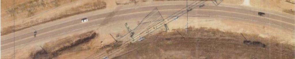
3 Part 1 Base Information 1. Project Title Marshall Road (SH 170) Underpass 2. Project Start/End points or Geographic Area Provide a map with submittal, as appropriate 3. Project Sponsor (entity that will construct/ complete and be financially responsible for the project) 4. Project Contact Person, Title, Phone Number, and US 36 Davidson Mesa Underpass to south of Marshall Road Town of Superior Alex Ariniello, Public Works Director, x111, alexa@superiorcolorado.gov 5. Does this project touch CDOT Right of Way, involve a CDOT roadway, access RTD property, or request RTD involvement to operate service? 6. What planning document(s) identifies this project? Yes No If yes, provide applicable concurrence documentation with submittal DRCOG 2040 Fiscally Constrained Regional Transportation Plan (2040 FCRTP) Local plan: 7. Identify the project s key elements. Other(s): Rapid Transit Capacity (2040 FCRTP) Transit Other: Transit Priority Lanes Bicycle Facility Pedestrian Facility Safety Improvements Roadway Capacity or Managed Lanes (2040 FCRTP) Roadway Operational Superior Trails Plan Provide link to document/s and referenced page number if possible, or provide documentation with submittal Grade Separation Roadway Railway Bicycle Pedestrian Roadway Pavement Reconstruction/Rehab Bridge Replace/Reconstruct/Rehab Study Design Other: 8. Problem Statement What specific Metro Vision related regional problem/issue will the transportation project address? The Marshall Road Underpass project will address regional multi use trail connections along the US 36 multi modal corridor. It will improve transportation safety and security by providing a grade separated trail crossing of a busy high speed highway. Marshall Road (SH 170) carries 6,000 vehicles per day at this crossing and the speed limit is 50 mph. The project thus directly relates to the DRCOG Metro Vision Theme of A Connected Multimodal Region with Outcomes The regional transportation system is well connected and serves all modes of travel. The transportation system is safe, reliable and well maintained. 3
4 9. Define the scope and specific elements of the project. This project would construct an underpass of Marshall Road to accommodate a 10 ft.-wide multi-use concrete trail connecting the US 36 Davidson Mesa underpass to Marshall Road. 10. What is the status of the proposed project? Conceptual Design 11. Would a smaller federal funding amount than requested be acceptable, while maintaining the original intent of the project? Yes No If yes, define smaller meaningful limits, size, service level, phases, or scopes, along with the cost for each. A. Project Financial Information and Funding Request 1. Total Project Cost $1,800, Total amount of DRCOG Subregional Share Funding Request (no greater than $20 million and not to exceed 50% of the total project cost) $1,440,000 80% of total project cost 3. Outside Funding Partners (other than DRCOG Regional Share funds) List each funding partner and contribution amount. $$ Contribution Amount % of Contribution to Overall Total Project Cost Town of Superior $360,000 20% Total amount of funding provided by other funding partners (private, local, state, Subregion, or federal) $360,00 20% Funding Breakdown (year by year)* *The proposed funding plan is not guaranteed if the project is selected for funding. While DRCOG will do everything it can to accommodate the applicants request, final funding will be assigned at DRCOG s discretion within fiscal constraint. Funding amounts must be provided in year of expenditure dollars using an inflation factor of 3% per year from FY 2020 FY 2021 FY 2022 FY 2023 Total Federal Funds (Regional) $0 $300,000 $1,140,000 $0 $1,440,000 Federal Funds (Subregional) $0 $0 $0 $0 $0 State Funds $0 $0 $0 $0 $0 Local Funds $0 $60,000 $300,000 $0 $360,000 4
5 Total Funding $0 $360,000 $1,440,000 $0 $1,800, Phase to be Initiated Choose from Design, ENV, ROW, CON, Study, Service, Equip. Purchase, Other Design CON 5. By checking this box, the applicant s Chief Elected Official (Mayor or County Commission Chair) or City/County Manager for local governments or Agency Director or equivalent for others, has certified it allows this project request to be submitted for DRCOG allocated funding and will follow all DRCOG policies and state and federal regulations when completing this project, if funded. 5
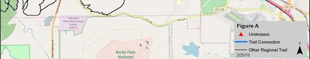
6 Part 2 Evaluation Criteria, Questions, and Scoring A. Regional significance of proposed project WEIGHT 40% Provide qualitative and quantitative (derived from Part 3 of the application) responses to the following questions on the regional significance of the proposed project. 1. Why is this project regionally important? As Figure A illustrates the Marshall Road Underpass is located at the junction of two regional multi use trails. The US 36 Bikeway is a concrete 12 ft. wide multi use trail connecting the City of Boulder and communities along the US 36 Corridor. Perpendicular to this is a developing multi use trail that runs northeast through Louisville and into Lafayette. Several grade separated underpasses have been built or are in planning to provide a safe route to access open space and recreational amenities. Southwest of Marshall Road is an extensive network of trails on Superior, Boulder and Boulder County Open Space lands extending to Eldorado Canyon State Park on the west and connecting to Jefferson County on the south. The Marshall Road underpass will connect these two trail networks with a safe crossing of a high speed highway. 2. Does the proposed project cross and/or benefit multiple municipalities? If yes, which ones and how? The Marshall Road underpass will provide a safe trail connection between the Louisville and Superior trail networks. These trail networks also connect to trail networks in Lafayette and Boulder, providing benefits to residents in those communities. 3. Does the proposed project cross and/or benefit another subregion(s)? If yes, which ones and how? City & County of Broomfield residents can use the US 36 Bikeway and the Marshall Road underpass to access the Superior and Boulder County trail networks southwest of the project. 4. How will the proposed project address the specific transportation problem described in the Problem Statement (as submitted in Part 1, #8)? Currently, users of the US 36 Davidson underpass must cross Marshall Road (SH 170) to access the Superior and Bolder County trail network located southwest of Marshall Road. Near this location, SH 170 is posted at 50 mph and the traffic volume is 6,000 vehicles per day presenting a potentially dangerous at grade crossing. The project will provide a safe grade separation of Marshall Road, eliminating the vehicle bicycle conflcits. 5. One foundation of a sustainable and resilient economy is physical infrastructure and transportation. How will the completed project allow people and businesses to thrive and prosper? The project will provide a safe pedestrian and bike connection for nearby residential, employment, retail and recreation areas facilitating trip making by alternative modes, which use less energy than vehicular modes. 6. How will connectivity to different travel modes be improved by the proposed project? The project will improve the safety of bicycle and pedestrian trail users. 7. Describe funding and/or project partnerships (other subregions, regional agencies, municipalities, private, etc.) established in association with this project. The attached letters of support from Boulder County and the City of Louisville indicate support of the project. Superior will be the lead agency but the local match will be split among these partners. 6
7 B. DRCOG Board approved Metro Vision TIP Focus Areas WEIGHT 30% Provide qualitative and quantitative (derived from Part 3 of the application) responses to the following questions on how the proposed project addresses the three DRCOG Board approved Focus Areas (in bold). 1. Describe how the project will improve mobility infrastructure and services for vulnerable populations (including improved transportation access to health services). Nearby vulnerable trail users will now have safer access to recreational opportunities. 2. Describe how the project will increase reliability of existing multimodal transportation network. Trail users will now be able to reliably cross Marshall Road without having to wait for an acceptable gap in a high volume, high speed traffic flow. 3. Describe how the project will improve transportation safety and security. The project will provide a gradeseparated underpass of Marshall Road eliminating vehicle/trail user crossing conflicts on this high speed highway. C. Consistency & Contributions to Transportation focused Metro Vision Objectives WEIGHT 20% Provide qualitative and quantitative responses (derived from Part 3 of the application) to the following items on how the proposed project contributes to Transportation focused Objectives (in bold) in the adopted Metro Vision plan. Refer to the expanded Metro Vision Objective by clicking on links. MV objective 2 Contain urban development in locations designated for urban growth and services. 1. Will this project help focus and facilitate future growth in locations where urban level infrastructure already exists or areas where plans for infrastructure and service expansion are in place? The trail will serve existing jurisdictions where infrastructure is in place. Yes No MV objective 3 Increase housing and employment in urban centers. 2. Will this project help establish a network of clear and direct multimodal connections within and between urban centers, or other key destinations? The project will provide multi use trail connections between Superior, Louisville and Boulder County trail networks. Yes No Improve or expand the region s multimodal transportation system, services, and MV objective 4 connections. 3. Will this project help increase mobility choices within and beyond the region for people, goods, or services? The project provides multi use trail connections between Superior, Yes Louisville and Boulder County trail networks thereby encouraging use of non motorized modes of transportation. No 7
8 MV objective 6a Improve air quality and reduce greenhouse gas emissions. 4. Will this project help reduce ground level ozone, greenhouse gas emissions, carbon monoxide, particulate matter, or other air pollutants? The project is expected to reduce greenhouse gas emissions by lbs. per day upon project opening; and lbs. per day in See Part 3 B & C for greenhouse gas emission reduction calculations. Yes No MV objective 7b Connect people to natural resource or recreational areas. 8. Will this project help complete missing links in the regional trail and greenways network or improve other multimodal connections that increase accessibility to our region s open space assets? As Figure A illustrates the Marshall Road Underpass is located at the junction of two regional multi use trails. The US 36 Bikeway is a concrete 12 ft. wide multi use trail connecting the City of Boulder and communities along the US 36 Corridor. Perpendicular to this is a developing multi use trail that runs northeast through Louisville and into Lafayette. Several grade separated underpasses exist or are in planning to provide a safe route to access open space and recreational amenities. Southwest of Marshall Road is an extensive network of trails on Superior, Boulder and Boulder County Open Space lands extending to Eldorado Canyon State Park on the west and connecting to Jefferson County on the south. The Marshall Road underpass will connect these two trail networks with a safe crossing of a high speed highway. Yes No MV objective 10 Increase access to amenities that support healthy, active choices. 5. Will this project expand opportunities for residents to lead healthy and active lifestyles? By providing a safe underpass that connects several trail networks residents of Louisville and Superior will now have access to many miles of safe multi use trails connecting to many recreational opportunities. Yes No MV objective 13 Improve access to opportunity. 6. Will this project help reduce critical health, education, income, and opportunity disparities by promoting reliable transportation connections to key destinations and other amenities? The project will provide a safe trail crossing of a busy highway. Yes No MV objective 14 Improve the region s competitive position. 7. Will this project help support and contribute to the growth of the region s economic health and vitality? By providing a safe underpass that connects several trail networks, residents of Louisville and Superior will now have access to many miles of safe multi use trails connecting to many recreational opportunities which will contribute to the region s attractiveness as a place to live and work. 8 Yes No
9 D. Project Leveraging WEIGHT 10% 8. What percent of outside funding sources (non DRCOG allocated Regional Share funding) does this project have? 20% 80%+ outside funding sources... High 60 79%... Medium 59% and below... Low Part 3 A. Transit Use Project Data Worksheet Calculations and Estimates (Complete all subsections applicable to the project) 1. Current ridership weekday boardings 2. Population and Employment Year Population within 1 mile Employment within 1 mile Total Pop and Employ within 1 mile Transit Use Calculations 3. Enter estimated additional daily transit boardings after project is completed. (Using 50% growth above year of opening for 2040 value, unless justified) Provide supporting documentation as part of application submittal 4. Enter number of the additional transit boardings (from #3 above) that were previously using a different transit route. (Example: {#3 X 25%} or other percent, if justified) 5. Enter number of the new transit boardings (from #3 above) that were previously using other non SOV modes (walk, bicycle, HOV, etc.) (Example: {#3 X 25%} or other percent, if justified) 6. = Number of SOV one way trips reduced per day (#3 #4 #5) 7. Enter the value of {#6 x 9 miles}. (= the VMT reduced per day) (Values other than the default 9 miles must be justified by sponsor; e.g., 15 miles for regional service or 6 miles for local service) 8. = Number of pounds GHG emissions reduced (#7 x 0.95 lbs.) Year of Opening 2040 Weekday Estimate 9. If values would be distinctly greater for weekends, describe the magnitude of difference: 10. If different values other than the suggested are used, please explain here: 9
10 B. Bicycle Use 1. Current weekday bicyclists 300 bicyclists 2. Population and Employment Year Population within 1 mile Employment within 1 mile Total Pop and Employ within 1 mile ,749 4,290 6, ,022 5,713 9,735 Bicycle Use Calculations 3. Enter estimated additional weekday one way bicycle trips on the facility after project is completed. 4. Enter number of the bicycle trips (in #3 above) that will be diverting from a different bicycling route. (Example: {#3 X 50%} or other percent, if justified) Year of Opening 2040 Weekday Estimate = Initial number of new bicycle trips from project (#3 #4) Enter number of the new trips produced (from #5 above) that are replacing an SOV trip. (Example: {#5 X 30%} (or other percent, if justified) = Number of SOV trips reduced per day (#5 #6) Enter the value of {#7 x 2 miles}. (= the VMT reduced per day) (Values other than 2 miles must be justified by sponsor) = Number of pounds GHG emissions reduced (#8 x 0.95 lbs.) If values would be distinctly greater for weekends, describe the magnitude of difference: 11. If different values other than the suggested are used, please explain here: C. Pedestrian Use 1. Current weekday pedestrians (include users of all non pedaled devices) Population and Employment Year Population within 1 mile Employment within 1 mile Total Pop and Employ within 1 mile ,749 4,290 6, ,022 5,713 9,735 Pedestrian Use Calculations Year of Opening 2040 Weekday Estimate 10
11 3. Enter estimated additional weekday pedestrian one way trips on the facility after project is completed 4. Enter number of the new pedestrian trips (in #3 above) that will be diverting from a different walking route (Example: {#3 X 50%} or other percent, if justified) = Number of new trips from project (#3 #4) Enter number of the new trips produced (from #5 above) that are replacing an SOV trip. (Example: {#5 X 30%} or other percent, if justified) = Number of SOV trips reduced per day (#5 #6) Enter the value of {#7 x.4 miles}. (= the VMT reduced per day) (Values other than.4 miles must be justified by sponsor) = Number of pounds GHG emissions reduced (#8 x 0.95 lbs.) If values would be distinctly greater for weekends, describe the magnitude of difference: 10. If different values other than the suggested are used, please explain here: D. Vulnerable Populations Vulnerable Populations Population within 1 mile Use Current Census Data 1. Persons over age Minority persons Low Income households Linguistically challenged persons 0 5. Individuals with disabilities Households without a motor vehicle Children ages Health service facilities served by project 3 E. Travel Delay (Operational and Congestion Reduction) Sponsor must use industry standard Highway Capacity Manual (HCM) based software programs and procedures as a basis to calculate estimated weekday travel delay benefits. DRCOG staff may be able to use the Regional Travel Model to develop estimates for certain types of large scale projects. 1. Current ADT (average daily traffic volume) on applicable segments ADT estimate 0 3. Current weekday vehicle hours of delay (VHD) (before project) 0 11
12 Travel Delay Calculations Year of Opening 4. Enter calculated future weekday VHD (after project) 0 5. Enter value of {#3 #4} = Reduced VHD 0 6. Enter value of {#5 X 1.4} = Reduced person hours of delay (Value higher than 1.4 due to high transit ridership must be justified by sponsor) 0 7. After project peak hour congested average travel time reduction per vehicle (includes persons, transit passengers, freight, and service equipment carried by vehicles). If applicable, denote unique travel time reduction for certain types of vehicles 0 8. If values would be distinctly different for weekend days or special events, describe the magnitude of difference. 9. If different values other than the suggested are used, please explain here: F. Traffic Crash Reduction 1. Provide the current number of crashes involving motor vehicles, bicyclists, and pedestrians (most recent 5 year period of data) Fatal crashes 0 Serious Injury crashes 0 Other Injury crashes 4 Property Damage Only crashes 0 2. Estimated reduction in crashes applicable to the project scope (per the five year period used above) Fatal crashes reduced 0 Serious Injury crashes reduced 0 Other Injury crashes reduced 2 Sponsor must use industry accepted crash reduction factors (CRF) or accident modification factor (AMF) practices (e.g., NCHRP Project 17 25, NCHRP Report 617, or DiExSys methodology). Property Damage Only crashes reduced 0 G. Facility Condition Sponsor must use a current industry accepted pavement condition method or system and calculate the average condition across all sections of pavement being replaced or modified. Applicants will rate as: Excellent, Good, Fair, or Poor Roadway Pavement 1. Current roadway pavement condition 2. Describe current pavement issues and how the project will address them. 3. Average Daily User Volume Bicycle/Pedestrian/Other Facility 4. Current bicycle/pedestrian/other facility condition Choose an item 12
13 5. Describe current condition issues and how the project will address them. 6. Average Daily User Volume 0 H. Bridge Improvements 1. Current bridge structural condition from CDOT 2. Describe current condition issues and how the project will address them. 3. Other functional obsolescence issues to be addressed by project 4. Average Daily User Volume over bridge I. Other Beneficial Variables (identified and calculated by the sponsor) J. Disbenefits or Negative Impacts (identified and calculated by the sponsor) 1. Increase in VMT? If yes, describe scale of expected increase Yes No 2. Negative impact on vulnerable populations No 3. Other: 13


14 Marshall Underpass Regional Trail Context Map 14


15 Marshall Underpass Conceptual Drawing 15
16 Town of Superior 5-Year Trails Plan Proposed Marshall Road Underpass 3 Trail System Local Regional Potential Town Boundary Miles Created by Town of Superior August 15, 2018 Copyright nearmap 2015


17
18
19 DATE: February 26, 2019 TO: Alex Ariniello, PE Public Works Director FROM: Jake Kononov, PE DiExSys SUBJECT: Safety Assessment Report in Support of DRCOG TIP Application for Multipurpose Trail Underpass under SH170A Attached for your review is a copy of the Safety Assessment Report for the above referenced project. The observations and recommendations in this report are based on the analysis of 5 years of crash history and review of Google Earth Images. The Town is advised to verify through field survey the observations made in this report regarding physical features, roadside characteristics, and traffic control devices in the study area. Should any questions arise concerning this report or if further assistance is needed, please do not hesitate to contact me at Town of Superior Colorado February 2019 Safety Assessment Report SH170 Underpass

20 Safety Assessment Report In Support of DRCOG TIP Application Marshall Road Underpass (SH170A) Reproduction of any Portion of this Document is Prohibited without Expressed Written Authority from the City and County of Denver Public Works Traffic Engineering Services. Town of Superior Colorado February 2019 Safety Assessment Report SH170 Underpass
21 This report is prepared solely for the purpose of identifying, evaluating and planning safety improvements on public roads. It is subject to the provisions of 23 U.S.C.A. 409, and therefore is not subject to discovery and is excluded from evidence. Applicable provisions of 23 U.S.C.A. 409 are cited below: Notwithstanding any other provision of law, reports, surveys, schedules, lists, or data compiled or collected for the purpose of identifying, evaluating, or planning the safety enhancement of potential accident sites, hazardous roadway conditions, or railway-highway crossings, pursuant to sections 130, 144, and 152 of this title or for the purpose of developing any highway safety construction improvement project which may be implemented utilizing Federal-aid highway funds shall not be subject to discovery or admitted into evidence in a Federal or State court proceeding or considered for other purposes in any action for damages arising from any occurrence at a location mentioned or addressed in such reports, surveys, schedules, lists or data. Any intentional or inadvertent release of this report, or any data derived from its use shall not constitute a waiver of privilege pursuant to 23 U.S.C.A Town of Superior Colorado February 2019 Safety Assessment Report SH170 Underpass

22 STATEMENT OF PHILOSOPHY The efficient and responsible investment of resources in addressing safety problems is a difficult task. Since crashes occur on all roadways in use, it is inappropriate to say of any roadway that it is safe. However, it is correct to say that roadways can be built to be safer or less safe. Road safety is a matter of degree. When making decisions effecting road safety it is critical to understand that expenditure of limited available funds on improvements in places where it prevents few injuries and saves few lives can mean that injuries will occur and lives will be lost by not spending them in places where more crashes could have been prevented 1. It is the Town s of Superior objective to maximize crash reduction within the limitations of available budgets by making road safety improvements at locations where it does the most good or prevents the most crashes. INTRODUCTION The primary intent of this project is to construct multipurpose underpass under SH170A and link it with existing system of trails. In connection with project an opportunity exists to improve pedestrian and bicycle safety on SH170A. Between 1/1/2012 and 12/31/2016 (5 year study period) 2 pedestrian and 2 bicycle crashes occurred on SH170A MP (Figure 1). All 4 of them involved collision with a vehicle (Figure 2). Figure 1 1 Hauer, E., (1999) Safety Review of Highway 407: Confronting Two Myths. TRB Town of Superior Colorado February 2019 Safety Assessment Report SH170 Underpass
, however, can potentially be remedied by constructing proposed underpass under SH170A between")

23 Only 2 bicycle crashes (MP 5.01 and MP 5.99), however, can potentially be remedied by constructing proposed underpass under SH170A between approximately MP 5.50 and MP 5.60 (Figure 3). Both of these bicycle crashes resulted in injury. Figure 3 Locations of Bicycle Crashes Susceptible to Correction by Constructing an Underpass under SH170A Town of Superior Colorado February 2019 Safety Assessment Report SH170 Underpass

.")
24 Assuming that constructing an underpass and creating a separation between vehicular and pedestrian/bicycle traffic will result in complete crash prevention we conducted a Benefit/Cost analysis relating benefits of crash reduction to cost of construction. It shows if the underpass can be constructed for $300,000 the resulting ratio of benefits of crash reduction to cost of construction (B/C) is 2:1 (Figure 4). Breakeven point analysis shows that expenditure of up to up $600,000 can be justified purely from the safety standpoint (Figure 5). Figure 4 B/C Analysis for Underpass SH170A Figure 5 Breakeven Point Analysis for Underpass SH170A Town of Superior Colorado February 2019 Safety Assessment Report SH170 Underpass
Town of Superior. Superior Trails Plan
 Part 1 Base Information 1. Project Title US 36 Bikeway Extension 2. Project Start/End points or Geographic Area Provide a map with submittal, as appropriate 3. Project Sponsor (entity that will construct/
APPLICATION OVERVIEW APPLICATION FORM OUTLINE
 APPLICATION OVERVIEW 2020 2023 Transportation Improvement Program (TIP) Boulder County Subregional Share Project Application Form The Subregional Share Call for Projects will open on January 2, 2019, with
Base Information. 1. Project Title SH7/East Arapahoe Multi-Use Path and Transit Stop Improvements. 2. Project Start/End points or Geographic Area
 Part 1 Base Information 1. Project Title SH7/East Arapahoe Multi-Use Path and Transit Stop Improvements 2. Project Start/End points or Geographic Area 38 th /Marine streets to Cherryvale Road (See attached
Base Information. 1. Project Title County Line Road Shoulder Improvements. Start: County Line Road/17 th Avenue End: County Line Road/State Highway 66
 Part 1 Base Information 1. Project Title County Line Road Shoulder Improvements Start: County Line Road/17 th Avenue End: County Line Road/State Highway 66 2. Project Start/End points or Geographic Area
Base Information. 1. Project Title Erie Parkway and WCR 7 Traffic Signal Project
 Part 1 Base Information 1. Project Title Erie Parkway and WCR 7 Traffic Signal Project 2. Project Start/End points or Geographic Area Provide a map with submittal, as appropriate 3. Project Sponsor (entity
Base Information. 4. Project Contact Person, Title, Phone Number, and
 Part 1 Base Information 1. Project Title 30th Street (SH7/Arapahoe Avenue Boulder Creek) Corridor Improvements 2. Project Start/End points or SH7/Arapahoe Avenue Boulder Creek Geographic Area Provide a
Base Information. 1 st and Main Street, Longmont. Following the US287 corridor to US36 in Broomfield. Boulder County
 Part 1 Base Information 1. Project Title US 287 Bus Rapid Transit Feasibility and Corridor Safety Study 2. Project Start/End points or Geographic Area Provide a map with submittal, as appropriate 3. Project
Colorado Boulevard to US-85. City of Thornton. Darrell Alston, Traffic Engineer, ,
 Part 1 Base Information 1. Project Title 104 th Avenue (SH-44) Widening Colorado Boulevard to US-85 2. Project Start/End points or Geographic Area Provide a map with submittal, as appropriate 3. Project
City of Louisville, CO. Megan Davis, Deputy City Manager, ,
 Part 1 Base Information 1. Project Title South Boulder Road At-Grade Safety and Intersection Improvements 2. Project Start/End points or Geographic Area Provide a map with submittal, as appropriate 3.
City & County of Broomfield (project applicant) Colorado Dept of Transportation R1 (project lead)
 Colorado Dept of Transportation R1 (project lead)") Part 1 Base Information 1. Project Title US 287 / 120th Ave. Multimodal and Safety Study 2. Project Start/End points or Geographic Area Provide a map with submittal, as appropriate 3. Project Sponsor (entity
Part 1 Base Information 1. Project Title US 287 / 120th Ave. Multimodal and Safety Study 2. Project Start/End points or Geographic Area Provide a map with submittal, as appropriate 3. Project Sponsor (entity
City & County of Broomfield. Sarah Grant, Transportation Manager City & County of Broomfield
 Part 1 Base Information 1. Project Title Industrial Lane Bikeway Phase 2 2. Project Start/End points or Geographic Area Provide a map with submittal, as appropriate 3. Project Sponsor (entity that will
City of Boulder. Table Mesa park n Ride Multi Use Path and Access Improvements
 City of Boulder Table Mesa park n Ride Multi Use Path and Access Improvements 2020 2023 DRCOG Transportation Improvements Program (TIP) Subregional Share Project Application Form 0 Part 1 Base Information
Fulton Street, from Montview Boulevard to 26 th Avenue, located in Northwest Aurora (see Attachment A and Attachment B).
.") Part 1 Base Information 1. Project Title Fulton Street Bicycle Boulevard and Pedestrian Enhancements (Phase 2) 2. Project Start/End points or Geographic Area Provide a map with submittal, as appropriate
Part 1 Base Information 1. Project Title Fulton Street Bicycle Boulevard and Pedestrian Enhancements (Phase 2) 2. Project Start/End points or Geographic Area Provide a map with submittal, as appropriate
Broadway from Belleview Ave to C-470. City of Littleton. Keith Reester, Director of Public Works, ,
 Part 1 Base Information 1. Project Title Broadway Corridor Plan 2. Project Start/End points or Geographic Area Provide a map with submittal, as appropriate 3. Project Sponsor (entity that will construct/
From the W 48 th Avenue Intersection to the eastbound ramps for Interstate 70. City of Wheat Ridge
 Part 1 Base Information 1. Project Title Wadsworth Blvd Widening: 48 th Ave to I-70 2. Project Start/End points or Geographic Area Provide a map with submittal, as appropriate 3. Project Sponsor (entity
Base Information. Washington Street to approximately 150 east of the railroad tracks (near the Old York Street connection)
") Part 1 Base Information 1. Project Title 120 th Avenue Improvements 2. Project Start/End points or Geographic Area Provide a map with submittal, as appropriate 3. Project Sponsor (entity that will construct/
Part 1 Base Information 1. Project Title 120 th Avenue Improvements 2. Project Start/End points or Geographic Area Provide a map with submittal, as appropriate 3. Project Sponsor (entity that will construct/
Base Information. Yes No If yes, provide applicable concurrence documentation with submittal
 Part 1 Base Information 1. Project Title SH-86/5th Street and Founders Pkwy/Ridge Road Operational Intersection Improvements 2. Project Start/End points or see attached project map (Appendix B) Geographic
Base Information. 1. Project Title Nine Mile Pedestrian and Bicycle Bridge 2. Project Start/End points or Geographic Area
 Part 1 Base Information 1. Project Title Nine Mile Pedestrian and Bicycle Bridge 2. Project Start/End points or Geographic Area Provide a map with submittal, as appropriate 3. Project Sponsor (entity that
Base Information. 1. Project Title Parker/Quincy/Smoky Hill Intersection Improvements
 Part 1 Base Information 1. Project Title Parker/Quincy/Smoky Hill Intersection Improvements 2. Project Start/End points or Geographic Area Provide a map with submittal, as appropriate 3. Project Sponsor
Base Information. 1. Project Title
 Part 1 1. Project Title Base Information County Line Road Widening and Reconstruction Note: The project includes an updated Environmental Assessment (EA), final design, right-of-way acquisition, utility
City of Boulder. 30th Street (SH7/Arapahoe Avenue Boulder Creek) Corridor Improvements
 Corridor Improvements") City of Boulder 30th Street (SH7/Arapahoe Avenue Boulder Creek) Corridor Improvements DRCOG 2020-2023 DRCOG Transportation Improvements Program [Company (TIP) Subregional name] Share Project Application
City of Boulder 30th Street (SH7/Arapahoe Avenue Boulder Creek) Corridor Improvements DRCOG 2020-2023 DRCOG Transportation Improvements Program [Company (TIP) Subregional name] Share Project Application
Base Information. Montview Blvd on the north and Dartmouth Avenue on the south. City of Aurora
 Part 1 Base Information 1. Project Title Havana Street Transit Improvements 2. Project Start/End points or Geographic Area Provide a map with submittal, as appropriate 3. Project Sponsor (entity that will
Base Information. 1. Project Title. SH 83 (Parker Road) Safety Improvements Bayou Gulch Rd. to El Paso County Northern Boarder (Highlighted red)
 Safety Improvements Bayou Gulch Rd. to El Paso County Northern Boarder (Highlighted red)") Part 1 1. Project Title Base Information SH 83 Safety Improvements (Bayou Gulch Road to El Paso County) Note: project includes environmental, design, right-of-way acquisition, utility relocations and construction;
Part 1 1. Project Title Base Information SH 83 Safety Improvements (Bayou Gulch Road to El Paso County) Note: project includes environmental, design, right-of-way acquisition, utility relocations and construction;
Base Information. 1. Project Title Spruce Mountain Road Bicycle and Pedestrian Improvements
 Part 1 Base Information 1. Project Title Spruce Mountain Road Bicycle and Pedestrian Improvements 2. Project Start/End points or Geographic Area Provide a map with submittal, as appropriate 3. Project
Base Information. 1. Project Title US36 Multimodal Improvements
 Part 1 Base Information 1. Project Title US36 Multimodal Improvements 2. Project Start/End points or Geographic Area 3. Project Sponsor (entity that will construct/ complete and be financially responsible
, ; , Town of Lyons
 Part 1 Base Information 1. Project Title St. Vrain Regional Trail Extension 2. Project Start/End points or Geographic Area Provided: Map 3. Project Sponsor (entity that will construct/ complete and be
Appendix T 1: Additional Supporting Data
 Appendix T 1: Additional Supporting Data Project Delivery Delays with the implementation of the 2000 TIP became apparent early in the decade. In response to direction among policy officials, ARC began
Proposed. City of Grand Junction Complete Streets Policy. Exhibit 10
 Proposed City of Grand Junction Complete Streets Policy Exhibit 10 1 City of Grand Junction Complete Streets Policy Vision: The Complete Streets Vision is to develop a safe, efficient, and reliable travel
Transportation Master Plan Advisory Task Force
 Transportation Master Plan Advisory Task Force Network Alternatives & Phasing Strategy February 2016 BACKGROUND Table of Contents BACKGROUND Purpose & Introduction 2 Linking the TMP to Key Council Approved
MCTC 2018 RTP SCS and Madera County RIFP Multi-Modal Project Eval Criteria GV13.xlsx
 MCTC 8 RTP SCS and Madera County RIFP Multi-Modal Project Eval Criteria GV.xlsx Madera County Transportation Commission Regional Transportation Plan / Sustainable Communities Strategy Multi-Modal Project
Base Information. 1. Project Title State Highway 7 Preliminary & Environmental Engineering
 Part 1 Base Information 1. Project Title State Highway 7 Preliminary & Environmental Engineering 2. Project Start/End points or Geographic Area Provide a map with submittal, as appropriate 3. Project Sponsor
Bicycle Master Plan Goals, Strategies, and Policies
 Bicycle Master Plan Goals, Strategies, and Policies Mobilizing 5 This chapter outlines the overarching goals, action statements, and action items Long Beach will take in order to achieve its vision of
Goal 3: Foster an environment of partnerships and collaboration to connect our communities and regions to one another.
 Non-Motorized Transportation Plan (NMTP) Draft Vision, Goal and,, Tri-County Regional Planning Commission (TCRPC) Purpose The purpose of the Tri-County Regional Planning Commission (TCRPC) Non-Motorized
Goals, Objectives, and Policies
 Goals, Objectives, and Policies ADVISORY GROUP INPUT PUBLIC INPUT SNS PREVIOUS STUDIES RBPP Goals Vision Statement Southern Nevada will develop a safe, connected, and convenient walking and bicycling system
TRAFFIC IMPACT STUDY CRITERIA
 Chapter 6 - TRAFFIC IMPACT STUDY CRITERIA 6.1 GENERAL PROVISIONS 6.1.1. Purpose: The purpose of this document is to outline a standard format for preparing a traffic impact study in the City of Steamboat
Attachment A: Columbus Area Metropolitan Transportation Plan Objectives, Performance Measures, and Targets
 OBJECTIVE: Reduce the percentage of commuters driving alone, and increase the percentage of commuters riding transit, ing Reducing single occupancy auto commutes and increasing commuters using alternative
CITY OF BLOOMINGTON COMPLETE STREETS POLICY
 CITY OF BLOOMINGTON COMPLETE STREETS POLICY POLICY OBJECTIVE: The City of Bloomington will enhance safety, mobility, accessibility and convenience for transportation network users of all ages and abilities,
Exhibit 1 PLANNING COMMISSION AGENDA ITEM
 Exhibit 1 PLANNING COMMISSION AGENDA ITEM Project Name: Grand Junction Circulation Plan Grand Junction Complete Streets Policy Applicant: City of Grand Junction Representative: David Thornton Address:
Regional Transportation Needs Within Southeastern Wisconsin
 Regional Transportation Needs Within Southeastern Wisconsin #118274 May 24, 2006 1 Introduction The Southeastern Wisconsin Regional Planning Commission (SEWRPC) is the official areawide planning agency
The Florida Bicycle and Pedestrian Partnership Council
 The Florida Bicycle and Pedestrian Partnership Council Input to the Update of the Florida Transportation Plan March 2015 This document presents input from the Florida Bicycle and Pedestrian Advisory Council
North Coast Corridor:
 North Coast Corridor: Connecting People, Transportation & Environment Legislative Hearing: 11.8.10 1 North Coast Corridor Region s Lifeline A Regional Strategy Mobility, Economy & Environment North Coast
City of Novi Non-Motorized Master Plan 2011 Executive Summary
 City of Novi Non-Motorized Master Plan 2011 Executive Summary Prepared by: February 28, 2011 Why Plan? Encouraging healthy, active lifestyles through pathway and sidewalk connectivity has been a focus
BUILDING THE CASE FOR TRAVEL OPTIONS IN WASHING TON COUNTY. Image: Steve Morgan. Image: Steve Morgan
 BUILDING THE CASE FOR TRAVEL OPTIONS IN WASHING TON COUNTY Image: Steve Morgan Image: Steve Morgan Image: TriMet Image: TriMet WHAT ARE TRAVEL OPTIONS PROGRAMS? Travel options programs encourage residents,
Perryville TOD and Greenway Plan
 Perryville TOD and Greenway Plan Greenway Glossary Pathway: A bicycle and pedestrian path separated from motorized vehicular traffic by an open space, barrier or curb. Multi-use paths may be within the
City of Jacksonville Mobility Fee Update
 City of Jacksonville Mobility Fee Update 2017 Preliminary Analysis May 3, 2017 Carnival Cruise lines photo credit Presentation Overview Public Outreach Process Pedestrian and Bicycle Master Plan Study
RESOLUTION NO ?? A RESOLUTION OF THE CITY OF NEPTUNE BEACH ADOPTING A COMPLETE STREETS POLICY
 RESOLUTION NO. 2018-?? A RESOLUTION OF THE CITY OF NEPTUNE BEACH ADOPTING A COMPLETE STREETS POLICY WHEREAS, safe, convenient, and accessible transportation for all users is a priority of the City of Neptune
CITY OF SIGNAL HILL Cherry Avenue Signal Hill, CA
 CITY OF SIGNAL HILL 2175 Cherry Avenue Signal Hill, CA 90755-3799 AGENDA ITEM TO: HONORABLE MAYOR AND MEMBERS OF THE CITY COUNCIL FROM: STEVE MYRTER, P. E. DIRECTOR OF PUBLIC WORKS SUBJECT: SPRING STREET
ACTIVE TRANSPORTATION
 ACTIVE TRANSPORTATION Mobility 2040 Supported Goals Improve the availability of transportation options for people and goods. Support travel efficiency measures and system enhancements targeted at congestion
Active Transportation Infrastructure Investment A Business Case
 Active Transportation Infrastructure Investment A Business Case In 2016, the Real Estate Foundation awarded the Capital Regional District a $50,000 grant for Shifting Gears: Land Use Change through Active
Purpose and Need. Chapter Introduction. 2.2 Project Purpose and Need Project Purpose Project Need
 Chapter 2 Purpose and Need 2.1 Introduction The El Camino Real Bus Rapid Transit (BRT) Project (Project) would make transit and other transportation improvements along a 17.6-mile segment of the El Camino
SANTA CLARA COUNTYWIDE BICYCLE PLAN August 2008
 SANTA CLARA COUNTYWIDE BICYCLE PLAN August 2008 To assist VTA and Member Agencies in the planning, development and programming of bicycle improvements in Santa Clara County. Vision Statement To establish,
Click to edit Master title style Click to edit Master title style
 Click to edit Master title style Click to edit Master title style Transportation in the Denver Region Presented by: Jacob Riger, AICP September 28, 2017 Click Today s Click to Topics edit edit Master title
TRANSIT & NON-MOTORIZED PLAN DRAFT FINAL REPORT Butte County Association of Governments
 1 INTRODUCTION Maintaining a high quality of life is the essence of this plan for transit and non-motorized transportation in Butte County. Curbing greenhouse gas emissions (GHG) by reducing congestion,
TOWN OF PORTLAND, CONNECTICUT COMPLETE STREETS POLICY
 TOWN OF PORTLAND, CONNECTICUT COMPLETE STREETS POLICY I. VISION, GOALS & PRINCIPLES VISION To improve the streets of Portland making them safer and more accessible for all users including pedestrians,
Community Task Force July 25, 2017
 Community Task Force July 25, 2017 Welcome and Introductions Project Partners Regional Transportation District (RTD) Colorado Department of Transportation (CDOT) Denver Regional Council of Governments
Prioritizing Transportation Policy and Funding for Active Transportation, Safety, Equity and Health
 Mayor Karl Dean, Chairman Prioritizing Transportation Policy and Funding for Active Transportation, Safety, Equity and Health Leslie A. Meehan, AICP Planning and Implementing the Active Community Webinar
Typical Rush Hour Commute. PennyforTransportation.com
 Typical Rush Hour Commute In the News Overview of the Plan Collaborative plan with projects in every community Prioritizing connectivity and congestion relief Dedicated transportation-specific funding;
AMATS Complete Streets Policy
 AMATS Complete Streets Policy Table of Contents: Section 1. Definition of Complete Streets Section 2. Principles of Complete Streets Section 3. Complete Streets Policy Section 4. Consistency Section 5.
Complete Street Analysis of a Road Diet: Orange Grove Boulevard, Pasadena, CA
 Complete Street Analysis of a Road Diet: Orange Grove Boulevard, Pasadena, CA Aaron Elias, Bill Cisco Abstract As part of evaluating the feasibility of a road diet on Orange Grove Boulevard in Pasadena,
2. Context. Existing framework. The context. The challenge. Transport Strategy
 Transport Strategy Providing quality connections Contents 1. Introduction 2. Context 3. Long-term direction 4. Three-year priorities 5. Strategy tree Wellington City Council July 2006 1. Introduction Wellington
El Paso County 2040 Major Transportation Corridors Plan
 El Paso County 2040 Major Transportation Corridors Plan Connect-our-County Online Transportation User Survey Preliminary Results June 24, 2010 Years of Residence 2. How many years have you LIVED HERE?
CITY OF COCOA BEACH 2025 COMPREHENSIVE PLAN. Section VIII Mobility Element Goals, Objectives, and Policies
 CITY OF COCOA BEACH 2025 COMPREHENSIVE PLAN Section VIII Mobility Element Goals, Objectives, and Policies Adopted August 6, 2015 by Ordinance No. 1591 VIII MOBILITY ELEMENT Table of Contents Page Number
I-105 Corridor Sustainability Study (CSS)
") I-105 Corridor Sustainability Study (CSS) Metro Streets and Freeways Subcommittee March 21, 2019 Gary Hamrick Cambridge Systematics, Inc. I-105 CSS Project History & Background Funded by Caltrans Sustainable
I-105 Corridor Sustainability Study (CSS) Metro Streets and Freeways Subcommittee March 21, 2019 Gary Hamrick Cambridge Systematics, Inc. I-105 CSS Project History & Background Funded by Caltrans Sustainable
Performance Criteria for 2035 Long Range Transportation Plan
 Minimizing Impacts on Natural, Historic, Cultural or Archeological Resources 2035 LRTP Weighting Factor: 7% Objective 1.1: Use appropriate planning and design criteria to protect and enhance the built
Moving Cambridge. City of Cambridge Transportation Master Plan Public Consultation Centre. March 7, :00 8:00 PM.
 City of Cambridge Transportation Master Plan Public Consultation Centre March 7, 2018 5:00 8:00 PM Region of Waterloo City of Cambridge Transportation Master Plan Public Consultation Centre March 7, 2018
Appendix A: Safety Assessment
 Appendix A: Safety Assessment Safety Assessment Appendix A A Statement of Philosophy The efficient and responsible investment of resources in addressing safety problems is a difficult task. Since crashes
WALKNBIKE DRAFT PLAN NASHVILLE, TENNESSEE EXECUTIVE SUMMARY NASHVILLE, TENNESSEE
 NASHVILLE, TENNESSEE EXECUTIVE SUMMARY Executive Summary A world-class multi-modal transportation system is essential to a vibrant city and better quality of life. -Mayor Barry The WalknBike plan aims
NM-POLICY 1: Improve service levels, participation, and options for non-motorized transportation modes throughout the County.
 Transportation PRINCE WILLIAM COUNTY 2008 COMPREHENSIVE PLAN NON-MOTORIZED PLAN CONTENTS Goals, Policies, and Action Strategies Table 4 (Bike Facility Classifications and Descriptions) Table 5 (Bike Facility
4. ENVIRONMENTAL IMPACT ANALYSIS 9. TRANSPORTATION AND TRAFFIC
 4. ENVIRONMENTAL IMPACT ANALYSIS 9. TRANSPORTATION AND TRAFFIC 4.9.1 INTRODUCTION The following section addresses the Proposed Project s impact on transportation and traffic based on the Traffic Study
Complete Streets Workshop Follow-up. April 27, 2011 Rockledge City Hall
 Complete Streets Workshop Follow-up April 27, 2011 Rockledge City Hall Agenda Complete Streets draft briefing presentation and sample policy language Share your Complete Streets projects and post workshop
Multi Modal Transit Access Plan KIPDA ID # 239. Project Type: STUDY
 Multi Modal Transit Access Plan KIPDA ID # 239 Project Type: STUDY Description: In conjunction with the results from Project Gobility and the Transit LOS Analysis, TARC seeks to examine the possibilities
Anne Arundel County BICYCLE, PEDESTRIAN, TRANSIT ASSESSMENT GUIDELINES
 Anne Arundel County BICYCLE, PEDESTRIAN, TRANSIT ASSESSMENT GUIDELINES December 2018 TABLE OF CONTENTS I. Executive Summary 3 II. When Is A Bicycle Pedestrian Transit Assessment (BPTA) Required? 4 III.
An Assessment of Potential Greenhouse Gas Emissions Reductions from Proposed On Street Bikeways
 An Assessment of Potential Greenhouse Gas Emissions Reductions from Proposed On Street Bikeways Through the Sustainable Bethlehem Initiative, the Town of Bethlehem has identified both the improvement of
Living Streets Policy
 Living Streets Policy Introduction Living streets balance the needs of motorists, bicyclists, pedestrians and transit riders in ways that promote safety and convenience, enhance community identity, create
City of Wayzata Comprehensive Plan 2030 Transportation Chapter: Appendix A
 A1. Functional Classification Table A-1 illustrates the Metropolitan Council s detailed criteria established for the functional classification of roadways within the Twin Cities Metropolitan Area. Table
Incorporating Health in Regional Transportation Planning
 Mayor Karl Dean, Chairman Incorporating Health in Regional Transportation Planning Leslie A. Meehan, AICP Center TRT Intervention Webinar January 29, 2013 Objectives for Today Background About the Nashville
Governor s Transportation Vision Panel
 Office of Governor Kate Brown Governor s Transportation Vision Panel JLA Public Involvement Project Overview The is a yearlong effort to develop a series of recommendations for the Governor that address
Philip Schaffner Minnesota Department of Transportation October 22, 2013
 Philip Schaffner Minnesota Department of Transportation October 22, 2013 Going beyond performance measures & targets MnDOT has been using performance-based planning and programming for 10 years, but CIMS
PEDESTRIAN ACTION PLAN
 ATTACHMENT 2 CITY OF SANTA MONICA PEDESTRIAN ACTION PLAN CITY OF SANTA MONICA PEDESTRIAN ACTION PLAN This page intentionally left blank EXECUTIVE SUMMARY CHAPTER 1 EXECUTIVE SUMMARY Setting the Stage
Circulation in Elk Grove includes: Motor vehicles, including cars and trucks
 Circulation, as it is used in this General Plan, refers to the many ways people and goods move from place to place in Elk Grove and the region. Circulation in Elk Grove includes: Motor vehicles, including
Overview. Illinois Bike Summit IDOT Complete Streets Policy Presentation. What is a Complete Street? And why build them? And why build them?
 Overview Illinois Bike Summit IDOT Complete Streets Policy Presentation Aren Kriks, P.E. District One Bicycle Coordinator and Bureau of Programming Project Engineer History of Complete Streets IDOT Policy
North Shore Transportation Improvement Strategy
 North Shore Transportation Improvement Strategy Preliminary, Near-term Recommendation 2016 April Transportation Improvement Strategy (TIS) Comprehensive and Analytical A multi-modal transportation strategy
Incorporating Health in Regional Transportation Planning
 Mayor Karl Dean, Chairman Incorporating Health in Regional Transportation Planning Leslie A. Meehan, AICP Center TRT Intervention Webinar January 29, 2013 Objectives for Today Background About the Nashville
5.0 Roadway System Plan
 Southwest Boise Transportation Study Page 16 5.0 Roadway System Plan The Roadway System Plan outlines roadway improvements in the Initial Study Area. It forecasts future deficiencies on the arterial system,
TRAFFIC STUDY GUIDELINES Clarksville Street Department
 TRAFFIC STUDY GUIDELINES Clarksville Street Department 9/1/2009 Introduction Traffic studies are used to help the city determine potential impacts to the operation of the surrounding roadway network. Two
Appendix F: Detailed Modeling Results
 Appendix F: Detailed Modeling Results TransAction Technical Report (This page intentionally left blank) METHODOLOGY FOR CALCULATION OF PERFORMANCE MEASURES F-3 (This page intentionally left blank) Approved
May 12, 2016 Metro Potential Ballot Measure Issue Brief: Local Return
 Summary: Local return is an important revenue source for cities to maintain their local transportation infrastructure. Most cities use their local return to operate small bus systems and repave streets,
Highway 49, Highway 351 and Highway 91 Improvements Feasibility Study Craighead County
 Highway 49, Highway 351 and Highway 91 Improvements Feasibility Study Craighead County Executive Summary March 2015 Highway 49, Highway 351 and Highway 91 Improvements Feasibility Study Craighead County
ACTIVE TRANSPORTATION/NONMOTORIZED TRANSPORTATION
 ACTIVE TRANSPORTATION/NONMOTORIZED TRANSPORTATION BACKGROUND Active transportation, also known as nonmotorized transportation, is increasingly recognized as an important consideration when planning and
APPENDIX A: Complete Streets Checklist DRAFT NOVEMBER 2016
 APPENDIX A: Complete Streets Checklist DRAFT NOVEMBER 2016 Complete Streets Checklist MetroPlan Orlando s Complete Streets Checklist is an internal planning tool for staff to further implementation of
DRAFT MOVING FORWARD RHODE ISLAND BICYCLE MOBILITY PLAN 2018 PREPARED FOR PREPARED BY IN ASSOCIATION WITH
 RHODE ISLAND MOVING FORWARD BICYCLE MOBILITY PLAN 2018 PREPARED FOR PREPARED BY IN ASSOCIATION WITH T AF CHAPTER 1 D R INTRODUCTION CHAPTER 3 ARTICULATES VISION Bicycling is safe, fun and practical in
DOT Performance Measurement and Reporting System
 November 2016 DOT Performance Measurement and Reporting System 1 2015 Transportation & Development Division Overview Arlington County is a national leader in sustainable transportation and smart growth.
Third Street Bridge & Corridor Project
 Third Street Bridge & Corridor Project Preparation for the FY2018 budget to commence October 1, 2017, includes funding to address a project that has been considered since 1994. The Third Street bridge
Basalt Creek Transportation Refinement Plan Recommendations
 Basalt Creek Transportation Refinement Plan Recommendations Introduction The Basalt Creek transportation planning effort analyzed future transportation conditions and evaluated alternative strategies for
A District Council of the Urban Land Institute
 A District Council of the Urban Land Institute Thank you to our sponsors! A District Council of the Urban Land Institute Thank you to our Community Partners! A District Council of the Urban Land Institute
Bicycle and Pedestrian Connectivity Study Phase 2
 Connectivity Study Phase 2 Process PROCESS OUTCOMES Phase Prepared By STEP I Public Participation and Outreach 1. RTP Outreach activities, and development of the Bike and Ped Task Force Phase 1 2011 OCPC
Madison Urban Area and Dane County. Bicycle Transportation Plan Summary. September Introduction. Bicycle Plan Scope and Planning Process
 Bicycle Transportation Plan Summary Madison Urban Area and Dane County Introduction September 2000 Bicycling is an important mode of transportation in the Madison urban area and countywide that is available
Active Transportation Goals
 Active Transportation Goals - 2017 1. Update shared Regional Priority Bicycle Routes Plan/Map 2. Cities and counties adopt Local Active Transportation Plans [that align with Regional Priority Plan/Map]
Bicycle-Pedestrian Master Plan Update
 Bicycle-Pedestrian Master Plan Update Planning & Zoning Commission November 29, 2017 Overview Project Purpose & Scope Project History Plan Vision & Goals Chapter 5: Making Connections-Beyond the Path Next
BELFAST RAPID TRANSIT. Ciarán de Búrca Director, Transport Projects Division Department for Regional Development
 BELFAST RAPID TRANSIT Ciarán de Búrca Director, Transport Projects Division Department for Regional Development Objectives of Belfast Rapid Transit To provide a modern, safe, efficient and high quality