APPLICATION OVERVIEW APPLICATION FORM OUTLINE
|
|
|
- Vanessa Burke
- 5 years ago
- Views:
Transcription
1 APPLICATION OVERVIEW Transportation Improvement Program (TIP) Boulder County Subregional Share Project Application Form The Subregional Share Call for Projects will open on January 2, 2019, with applications due no later than 3 p.m. on February 27, 2018 to your subregional forum. To be eligible to submit, at least one person from your agency must have attended one of the mandatory TIP training workshops (held August 8 and August 16) or a supplemental training held on September 14. Projects requiring CDOT and/or RTD concurrence must provide their official response with the application submittal. The CDOT/RTD concurrence request is due to CDOT/RTD no later than January 7, with CDOT/RTD providing a response no later than February 8. The form can be found here. Any applications submitted by regional or similar agencies (TMA s), or municipalities crossing multiple subregions, must be submitted through the subregional forum based on where the majority of the project is located. Data to help the sponsor fill out the application, especially Part 3, can be found here. If any sponsor wishes to request additional data or calculations from DRCOG staff, please submit your request to tcottrell@drcog.org no later than February 6, The application must be affirmed by either the applicant s City or County Manager or Chief Elected Official (Mayor or County Commission Chair) for local governments, or agency director or equivalent for other applicants. Further details on project eligibility, evaluation criteria, and the selection process are defined in the Policy on Transportation Improvement Program (TIP) Preparation: Procedures for Preparing the TIP, which can be found online here. APPLICATION FORM OUTLINE The TIP Subregional Share application contains three parts: base project information (Part 1), evaluation questions (Part 2), and data calculation estimates (Part 3). DRCOG staff will review each forum s submitted applications for eligibility. Each forum will be responsible for making a comprehensive evaluation of all eligible applications and rank ordering their submittals to determine their recommended projects and waiting lists. Forum recommendations will be forwarded to DRCOG staff for a final recommendation to the TAC, RTC, and DRCOG Board. Part 1 Base Information Applicants will enter foundational information for their project/program/study (hereafter referred to as project) in Part 1, including a Problem Statement, project description, and concurrence documentation from CDOT and/or RTD, if applicable. Part 1 will not be scored. Part 2 Evaluation Criteria, Questions, and Scoring This part includes four sections (A D) for the applicant to provide qualitative and quantitative responses to use for scoring projects. The outcomes from Part 3 should guide the applicant s responses in Part 2. Scoring Methodology: Each section will be scored using a scale of High Medium Low, relative to other applications received. The four sections in Part 2 are weighted and scored as follows: 1
2 Section A. Subregional Significance of Proposed Projects... 40% High Medium Low The project will significantly address a clearly demonstrated major subregional problem and benefit people and businesses from multiple subregions. The project will either moderately address a major problem or significantly address a moderate level subregional problem. The project will address a minor subregional problem. Section B. Metro Vision TIP Focus Areas... 30% High Medium Low The project will significantly improve the safety and/or security, significantly increase the reliability of the transportation network, and benefit a large number and variety of users (including vulnerable populations*). The project will moderately improve the safety and/or security, moderately increase the reliability of the transportation network, and benefit a moderate number and variety of users (including vulnerable populations*). The project will minimally improve the safety and/or security, minimally increase the reliability of the transportation network, and benefit a limited number and variety of users (including vulnerable populations*). *Vulnerable populations include: Individuals with disabilities, persons over age 65, and low income, minority, or linguistically challenged persons. Section C. Consistency & Contributions to Transportation focused Metro Vision Objectives... 20% Metro Vision guides DRCOG s work and establishes shared expectations with our region s many and various planning partners. The plan outlines broad outcomes, objectives, and initiatives established by the DRCOG Board to make life better for the region s residents. The degree to which the outcomes, objectives, and initiatives identified in Metro Vision apply in individual communities will vary. Metro Vision has historically informed other DRCOG planning processes, such as the TIP. High The project will significantly address Metro Vision transportation related objectives and is determined to be in the top third of applications based on the magnitude of benefits. Medium Low The project will moderately address Metro Vision transportation related objectives and is determined to be in the middle third of applications based on the magnitude of benefits. The project will slightly or not at all address Metro Vision transportation related objectives and is determined to be in the bottom third of applications based on the magnitude of benefits. Section D. Leveraging of non Subregional Share funds ( overmatch )... 10% Scores are assigned based on the percent of outside funding sources (non Subregional Share). % of Outside Funding (non Subregional Share) High 60% and above Medium 30 59% Low 29% and below Part 3 Project Data Calculations and Estimates Based on the applicant s project elements, sponsors will complete the appropriate sections to estimate usage or benefit values. Part 3 is not scored, and the quantitative responses should be used to back up the applicant s qualitative narrative. 2
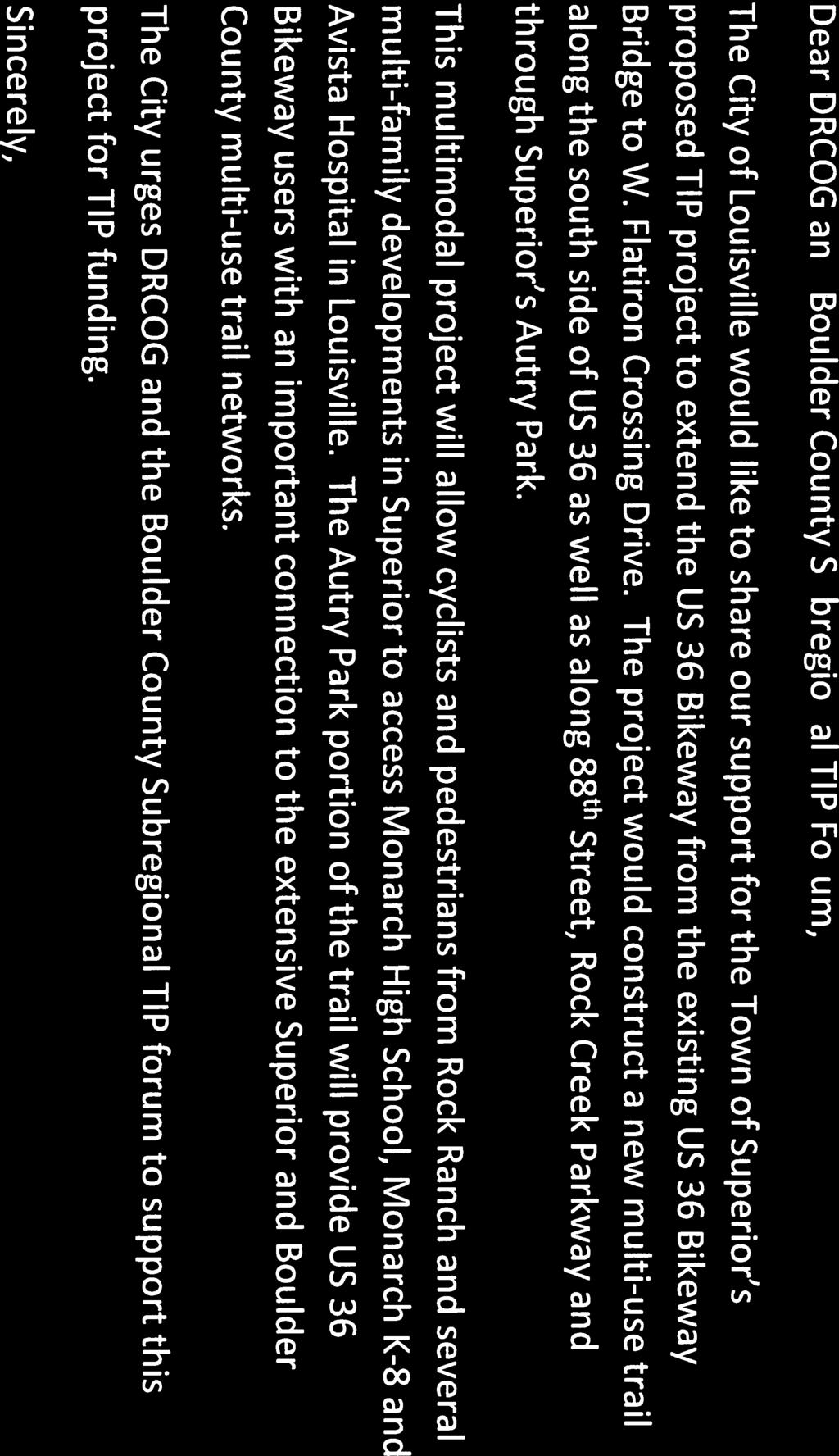
3 Part 1 Base Information 1. Project Title US 36 Bikeway Extension 2. Project Start/End points or Geographic Area Provide a map with submittal, as appropriate 3. Project Sponsor (entity that will construct/ complete and be financially responsible for the project) 4. Project Contact Person, Title, Phone Number, and US 36 Bikeway Bridge (near Avista Hospital) to W. Flatiron Crossing Drive Town of Superior Alex Ariniello, Public Works Director, x111, alexa@superiorcolorado.gov 5. Does this project touch CDOT Right of Way, involve a CDOT roadway, access RTD property, or request RTD involvement to operate service? 6. What planning document(s) identifies this project? 3 Yes No If yes, provide applicable concurrence documentation with submittal DRCOG 2040 Fiscally Constrained Regional Transportation Plan (2040 FCRTP) Local plan: 7. Identify the project s key elements. Other(s): Rapid Transit Capacity (2040 FCRTP) Transit Other: Transit Priority Lanes Bicycle Facility Pedestrian Facility Safety Improvements Roadway Capacity or Managed Lanes (2040 FCRTP) Roadway Operational Superior Trails Plan DRCOG Active Transportation Plan (Autry Park Segment) Provide link to document/s and referenced page number if possible, or provide documentation with submittal Grade Separation Roadway Railway Bicycle Pedestrian Roadway Pavement Reconstruction/Rehab Bridge Replace/Reconstruct/Rehab Study Design Other: 8. Problem Statement What specific Metro Vision related regional problem/issue will the transportation project address? The US 36 Bikeway Extension project will address regional multi use trail connections along the US 36 multi modal corridor. The project will directly connect Superior s new 150 acre mixed use Downtown Superior development with Broomfield s Flatiron Crossing and Interlocken mixed use developments. By connecting to the US 36 Bikeway, the project will allow Superior residents to access the BRT stations at McCaslin and Flatiron Crossing. The project will also connect several multi family developments in Superior with Monarch High School, Monarch K 8 and Avista Hospital in Louisville. The Autry Park portion of the trail will provide US 36 Bikeway users with an important connection to the extensive Superior and Boulder County multi use trail networks. The project thus directly relates to the DRCOG Metro Vision Theme of A Connected Multimodal Region with Outcomes The regional transportation system is well connected and serves all modes of travel. The transportation system is safe, reliable and well maintained.
4 9. Define the scope and specific elements of the project. This project would construct a 10 ft. wide multi use concrete trail along the south side of US 36 from the existing US 36 Bikeway bridge (near Avista Hospital) east under the US 36/88 th Street bridge. The trail would then turn south along the east side of 88 th Street and Rock Creek Parkway and then east through Autry Park to an existing underpass of W. Flatiron Crossing Drive. The total project length would be about 9,000 feet. 10. What is the status of the proposed project? Conceptual Design 11. Would a smaller federal funding amount than requested be acceptable, while maintaining the original intent of the project? Yes No If yes, define smaller meaningful limits, size, service level, phases, or scopes, along with the cost for each. A. Project Financial Information and Funding Request 1. Total Project Cost $2,500, Total amount of DRCOG Subregional Share Funding Request (no greater than $20 million and not to exceed 50% of the total project cost) $2,000,000 80% of total project cost 3. Outside Funding Partners (other than DRCOG Regional Share funds) List each funding partner and contribution amount. $$ Contribution Amount % of Contribution to Overall Total Project Cost Town of Superior $500,000 20% Total amount of funding provided by other funding partners (private, local, state, Subregion, or federal) $0 Funding Breakdown (year by year)* *The proposed funding plan is not guaranteed if the project is selected for funding. While DRCOG will do everything it can to accommodate the applicants request, final funding will be assigned at DRCOG s discretion within fiscal constraint. Funding amounts must be provided in year of expenditure dollars using an inflation factor of 3% per year from FY 2020 FY 2021 FY 2022 FY 2023 Total Federal Funds (Regional) $200,000 $1,800,000 $0 $0 $2,000,000 Federal Funds (Subregional) $0 $0 $0 $0 $0 State Funds $0 $0 $0 $0 $0 4
5 Local Funds $50,000 $450,000 $0 $0 $500,000 Total Funding $250,000 $2,250,000 $0 $0 $2,500, Phase to be Initiated Choose from Design, ENV, ROW, CON, Study, Service, Equip. Purchase, Other Design Construction 5. By checking this box, the applicant s Chief Elected Official (Mayor or County Commission Chair) or City/County Manager for local governments or Agency Director or equivalent for others, has certified it allows this project request to be submitted for DRCOG allocated funding and will follow all DRCOG policies and state and federal regulations when completing this project, if funded. 5
6 Part 2 Evaluation Criteria, Questions, and Scoring A. Regional significance of proposed project WEIGHT 40% Provide qualitative and quantitative (derived from Part 3 of the application) responses to the following questions on the regional significance of the proposed project. 1. Why is this project regionally important? The US 36 Bikeway Extension project will provide regional multi use trail connections along the US 36 multi modal corridor. By connecting to the US 36 Bikeway, the project will allow Superior residents to access the BRT stations at McCaslin and Flatiron Crossing. The project will also connect several multi family developments in Superior with Monarch High School, Monarch K 8 and Avista Hospital in Louisville. The Autry Park portion of the trail will provide US 36 Bikeway users with an important connection to the extensive Superior and Boulder County multi use trail networks. (see Figures A & B) 2. Does the proposed project cross and/or benefit multiple municipalities? If yes, which ones and how? The project provides connections to Louisville & Boulder County. Louisville residents can use the 88 th St/Rock Creek Parkway portions of the trail to Access Autry Park and the Rock Creek Trail which connects to the extensive Boulder County trail network located west of McCaslin Blvd. and eventually to the Rocky Mountain Greenway. Superior students can use the 88 th St/Rock Creek Parkway portions of the trail to access Monarch High School and Monarch K Does the proposed project cross and/or benefit another subregion(s)? If yes, which ones and how? The project provides a connection to the City & County of Broomfield Subregion. Broomfield residents (and other US 36 Bikeway users) can use the Autry Park portion of the trail to access the Rock Creek Trail which connects to the extensive Boulder County trail network located west of McCaslin Blvd. and eventually to the Rocky Mountain Greenway. In addition, Superior residents can use the Autry Park portion of the trail to access Flatiron Crossing, Interlocken Business Park, the US 36 Bikeway headed to the east and the Flatiron BRT station. 4. How will the proposed project address the specific transportation problem described in the Problem Statement (as submitted in Part 1, #8)? The US 36 Bikeway Extension project will address regional multi use trail connections along the US 36 multi modal corridor. The project will directly connect Superior s new 150 acre mixed use Downtown Superior development with Broomfield s Flatiron Crossing and Interlocken mixed use developments. By connecting to the US 36 Bikeway, the project will allow Superior residents to access the BRT stations at McCaslin and Flatiron Crossing. The project will also connect several multi family developments in Superior with Monarch High School, Monarch K 8 and Avista Hospital in Louisville. The Autry Park portion of the trail will provide US 36 Bikeway users with an important connection to the extensive Superior and Boulder County multi use trail networks. The project thus directly relates to the DRCOG Metro Vision Theme of A Connected Multimodal Region with Outcomes The regional transportation system is well connected and serves all modes of travel. The transportation system is safe, reliable and well maintained. 5. One foundation of a sustainable and resilient economy is physical infrastructure and transportation. How will the completed project allow people and businesses to thrive and prosper? The project will provide safe pedestrian and bike connections among residential, employment, retail and recreation areas facilitating trip making by alternative modes, which use less energy than vehicular modes. Businesses in Downtown Superior and Flatiron Crossing will benefit by the ease of alternative mode access by Superior and Broomfield residents. 6
7 6. How will connectivity to different travel modes be improved by the proposed project? Superior residents will be able to safely bike or walk to the McCaslin and Flatiron BRT Stations, encouraging use of public transit. 7. Describe funding and/or project partnerships (other subregions, regional agencies, municipalities, private, etc.) established in association with this project. The attached letters of support from Boulder County, Louisville and the City and County of Broomfield indicate support of the project from neighboring jurisdictions. B. DRCOG Board approved Metro Vision TIP Focus Areas WEIGHT 30% Provide qualitative and quantitative (derived from Part 3 of the application) responses to the following questions on how the proposed project addresses the three DRCOG Board approved Focus Areas (in bold). 1. Describe how the project will improve mobility infrastructure and services for vulnerable populations (including improved transportation access to health services). The project will provide connections to several multi family developments in Superior (Bell Flatiron, Saddlebrooke and Downtown Superior) facilitating sustainable alternative mode travel to employment, retail and recreation areas. These developments will also be connected by the project to health services available in Downtown Superior and in Avista Hospital and nearby medical facilities. 2. Describe how the project will increase reliability of existing multimodal transportation network. The project will be a multi use all weather concrete trail maintained to the same high standards as the US 36 Bikeway. It will not be subject to auto congestion or major incidents typically found on highway facilities. 3. Describe how the project will improve transportation safety and security. The project will provide a separated 10 ft. wide concrete trail connecting the US 36 Bikeway near Avista Hospital with the W. Flatiron Crossing Drive underpass. No major roadway at grade crossings will be needed although there will be three at grade crossings of local streets. It will provide a safe route to school for all Superior students living east of 88 th Street and desiring to bike or walk to Monarch High School of Monarch K 8 located north of US 36 in Louisville. Currently there is no walk on the east side of 88 th Street so students must cross 88 th Street (which carries 9,000 vehicles per day) twice to walk or bike to these schools. C. Consistency & Contributions to Transportation focused Metro Vision Objectives WEIGHT 20% Provide qualitative and quantitative responses (derived from Part 3 of the application) to the following items on how the proposed project contributes to Transportation focused Objectives (in bold) in the adopted Metro Vision plan. Refer to the expanded Metro Vision Objective by clicking on links. MV objective 2 Contain urban development in locations designated for urban growth and services. 1. Will this project help focus and facilitate future growth in locations where urban level infrastructure already exists or areas where plans for infrastructure and service expansion are in place? The project will directly connect Superior s new 150 acre mixed use Downtown Superior development with Broomfield s Flatiron Crossing and Interlocken mixed use developments. By connecting to the US 36 Bikeway, the project will allow Superior residents to access the BRT stations at McCaslin and Flatiron Crossing. The project will also connect several multi family developments in Superior with Monarch High School, Monarch K 8 and 7 Yes No
8 Avista Hospital in Louisville. The Autry Park portion of the trail will provide US 36 Bikeway users with an important connection to the extensive Superior and Boulder County multi use trail networks. MV objective 3 Increase housing and employment in urban centers. 2. Will this project help establish a network of clear and direct multimodal connections within and between urban centers, or other key destinations? The project will provide multi use trail connections between Superior and Louisville and the City and County of Broomfield. Destinations served included Autry Park, Monarch High School, Monarch K 8, Avista Hospital, Downtown Superior, Bell Flatiron (existing multi family development) Flatiron Crossing, Interlocken Business Park and the McCaslin and Flatiron Crossing BRT Stations. Yes No Improve or expand the region s multimodal transportation system, services, and MV objective 4 connections. 3. Will this project help increase mobility choices within and beyond the region for people, goods, or services? The project will provide multi use trail connections between Superior and Louisville and the City and County of Broomfield. The project will provide connections to the Yes McCaslin and Flatiron Crossing BRT Stations facilitating first and final mile connections of the Flatiron Flyer Regional BRT services to residents and employers of Superior, Louisville and Broomfield. No MV objective 6a Improve air quality and reduce greenhouse gas emissions. 4. Will this project help reduce ground level ozone, greenhouse gas emissions, carbon monoxide, particulate matter, or other air pollutants? The project is expected to reduce greenhouse gas emissions by lbs. per day upon project opening; and lbs. per day in See Part 3 A, B & C for greenhouse gas emission reduction calculations. Yes No MV objective 7b Connect people to natural resource or recreational areas. 5. Will this project help complete missing links in the regional trail and greenways network or improve other multimodal connections that increase accessibility to our region s open space assets? The Autry Park portion of the trail will provide Broomfield residents and employees, and US 36 Bikeway users with an important connection to the extensive Superior and Boulder County multi use trail networks. Yes No MV objective 10 Increase access to amenities that support healthy, active choices. 6. Will this project expand opportunities for residents to lead healthy and active lifestyles? The project will provide Superior residents with 9,000 feet of multi use trail expanding their 8 Yes No
9 opportunities for walking, biking and other recreational activities. It will extend the regional US 36 Bikeway facilities expanding the opportunities for US 36 Bikeway users. It will provide access to the amenities located in Autry Park to Louisville, Broomfield and other US 36 Corridor communities. The Autry Park portion of the trail will provide connections to the Superior and Boulder County trail networks to Broomfield and other US 36 Corridor communities. MV objective 13 Improve access to opportunity. 7. Will this project help reduce critical health, education, income, and opportunity disparities by promoting reliable transportation connections to key destinations and other amenities? The project will provide multi use trail connections between Superior and Louisville and the City and County of Broomfield. Destinations served included Autry Park, Monarch High School, Monarch K 8, Avista Hospital, Downtown Superior, Bell Flatiron (existing multi family development) Flatiron Crossing, Interlocken Business Park and the McCaslin and Flatiron Crossing BRT Stations. Yes No MV objective 14 Improve the region s competitive position. 8. Will this project help support and contribute to the growth of the region s economic health and vitality? The project will directly connect Superior s new 150 acre mixed use Downtown Superior development with Broomfield s Flatiron Crossing and Interlocken mixed use developments, supporting and enhancing the housing, employment and recreational opportunities of these important urban centers. By connecting to the US 36 Bikeway, the project will allow Superior residents to access the BRT stations at McCaslin and Flatiron Crossing. Yes No D. Project Leveraging WEIGHT 10% 9. What percent of outside funding sources (non DRCOG allocated Regional Share funding) does this project have? 20% 80%+ outside funding sources... High 60 79%... Medium 59% and below... Low 9
10 Part 3 A. Transit Use Project Data Worksheet Calculations and Estimates (Complete all subsections applicable to the project) 1. Current ridership weekday boardings 2. Population and Employment Year Population within 1 mile Employment within 1 mile Total Pop and Employ within 1 mile ,411 17,415 35, ,895 21,697 49,592 Transit Use Calculations 3. Enter estimated additional daily transit boardings after project is completed. (Using 50% growth above year of opening for 2040 value, unless justified) Provide supporting documentation as part of application submittal 4. Enter number of the additional transit boardings (from #3 above) that were previously using a different transit route. (Example: {#3 X 25%} or other percent, if justified) 5. Enter number of the new transit boardings (from #3 above) that were previously using other non SOV modes (walk, bicycle, HOV, etc.) (Example: {#3 X 25%} or other percent, if justified) Year of Opening 2040 Weekday Estimate = Number of SOV one way trips reduced per day (#3 #4 #5) Enter the value of {#6 x 9 miles}. (= the VMT reduced per day) (Values other than the default 9 miles must be justified by sponsor; e.g., 15 miles for regional service or 6 miles for local service) = Number of pounds GHG emissions reduced (#7 x 0.95 lbs.) If values would be distinctly greater for weekends, describe the magnitude of difference: 10. If different values other than the suggested are used, please explain here: B. Bicycle Use 1. Current weekday bicyclists 400 bicyclists per day on US 36 Bikeway in Broomfield 2. Population and Employment Year Population within 1 mile Employment within 1 mile Total Pop and Employ within 1 mile ,411 17,415 35, ,895 21,697 49,592 10
11 Bicycle Use Calculations 3. Enter estimated additional weekday one way bicycle trips on the facility after project is completed. 4. Enter number of the bicycle trips (in #3 above) that will be diverting from a different bicycling route. (Example: {#3 X 50%} or other percent, if justified) Year of Opening 2040 Weekday Estimate = Initial number of new bicycle trips from project (#3 #4) Enter number of the new trips produced (from #5 above) that are replacing an SOV trip. (Example: {#5 X 30%} (or other percent, if justified) = Number of SOV trips reduced per day (#5 #6) Enter the value of {#7 x 2 miles}. (= the VMT reduced per day) (Values other than 2 miles must be justified by sponsor) = Number of pounds GHG emissions reduced (#8 x 0.95 lbs.) If values would be distinctly greater for weekends, describe the magnitude of difference: 11. If different values other than the suggested are used, please explain here: C. Pedestrian Use 1. Current weekday pedestrians (include users of all non pedaled devices) Population and Employment Year Population within 1 mile Employment within 1 mile Total Pop and Employ within 1 mile ,411 17,415 35, ,895 21,697 49,592 Pedestrian Use Calculations 3. Enter estimated additional weekday pedestrian one way trips on the facility after project is completed 4. Enter number of the new pedestrian trips (in #3 above) that will be diverting from a different walking route (Example: {#3 X 50%} or other percent, if justified) Year of Opening 2040 Weekday Estimate = Number of new trips from project (#3 #4) Enter number of the new trips produced (from #5 above) that are replacing an SOV trip. (Example: {#5 X 30%} or other percent, if justified) = Number of SOV trips reduced per day (#5 #6)
12 12. Enter the value of {#7 x.4 miles}. (= the VMT reduced per day) (Values other than.4 miles must be justified by sponsor) = Number of pounds GHG emissions reduced (#8 x 0.95 lbs.) If values would be distinctly greater for weekends, describe the magnitude of difference: 10. If different values other than the suggested are used, please explain here: D. Vulnerable Populations Vulnerable Populations Population within 1 mile Use Current Census Data 1. Persons over age Minority persons Low Income households Linguistically challenged persons Individuals with disabilities Households without a motor vehicle Children ages Health service facilities served by project 9 E. Travel Delay (Operational and Congestion Reduction) Sponsor must use industry standard Highway Capacity Manual (HCM) based software programs and procedures as a basis to calculate estimated weekday travel delay benefits. DRCOG staff may be able to use the Regional Travel Model to develop estimates for certain types of large scale projects. 1. Current ADT (average daily traffic volume) on applicable segments ADT estimate 0 3. Current weekday vehicle hours of delay (VHD) (before project) 0 Travel Delay Calculations Year of Opening 4. Enter calculated future weekday VHD (after project) 0 5. Enter value of {#3 #4} = Reduced VHD 0 6. Enter value of {#5 X 1.4} = Reduced person hours of delay (Value higher than 1.4 due to high transit ridership must be justified by sponsor) 7. After project peak hour congested average travel time reduction per vehicle (includes persons, transit passengers, freight, and service equipment carried by vehicles). If applicable, denote unique travel time reduction for certain types of vehicles
13 8. If values would be distinctly different for weekend days or special events, describe the magnitude of difference. 9. If different values other than the suggested are used, please explain here: F. Traffic Crash Reduction 1. Provide the current number of crashes involving motor vehicles, bicyclists, and pedestrians (most recent 5 year period of data) Fatal crashes 0 Serious Injury crashes 0 Other Injury crashes 0 Property Damage Only crashes 0 2. Estimated reduction in crashes applicable to the project scope (per the five year period used above) Fatal crashes reduced 0 Serious Injury crashes reduced 0 Other Injury crashes reduced 0 Sponsor must use industry accepted crash reduction factors (CRF) or accident modification factor (AMF) practices (e.g., NCHRP Project 17 25, NCHRP Report 617, or DiExSys methodology). Property Damage Only crashes reduced 0 G. Facility Condition Sponsor must use a current industry accepted pavement condition method or system and calculate the average condition across all sections of pavement being replaced or modified. Applicants will rate as: Excellent, Good, Fair, or Poor Roadway Pavement 1. Current roadway pavement condition 2. Describe current pavement issues and how the project will address them. 3. Average Daily User Volume Bicycle/Pedestrian/Other Facility 4. Current bicycle/pedestrian/other facility condition Choose an item 5. Describe current condition issues and how the project will address them. 6. Average Daily User Volume 0 H. Bridge Improvements 1. Current bridge structural condition from CDOT 13
14 2. Describe current condition issues and how the project will address them. 3. Other functional obsolescence issues to be addressed by project 4. Average Daily User Volume over bridge I. Other Beneficial Variables (identified and calculated by the sponsor) J. Disbenefits or Negative Impacts (identified and calculated by the sponsor) 1. Increase in VMT? If yes, describe scale of expected increase Yes No 2. Negative impact on vulnerable populations 3. Other: 14
15 Town of Superior 5-Year Trails Plan 3 Trail System Local Regional Potential Town Boundary Miles Proposed US Bikeway Extension Autrey Park Segment Created by Town of Superior August 15, 2018 Copyright nearmap 2015


16 US 36 Bikeway Extension Conceptual Alignment 15

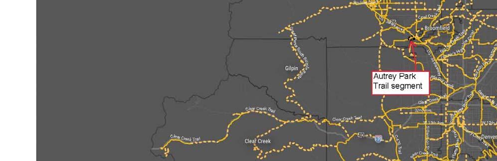

17 DRCOG Active Transportation Plan Autrey Park Segment 16


18 US 36 Bikeway Extension Regional Trails Context 17


19 US 36 Bikeway Extension Land Use Context 18


20
21


22
Town of Superior. Superior Trails Plan
 Part 1 Base Information 1. Project Title US 36 Bikeway Extension 2. Project Start/End points or Geographic Area Provide a map with submittal, as appropriate 3. Project Sponsor (entity that will construct/
Base Information. 1. Project Title SH7/East Arapahoe Multi-Use Path and Transit Stop Improvements. 2. Project Start/End points or Geographic Area
 Part 1 Base Information 1. Project Title SH7/East Arapahoe Multi-Use Path and Transit Stop Improvements 2. Project Start/End points or Geographic Area 38 th /Marine streets to Cherryvale Road (See attached
Base Information. 1. Project Title Erie Parkway and WCR 7 Traffic Signal Project
 Part 1 Base Information 1. Project Title Erie Parkway and WCR 7 Traffic Signal Project 2. Project Start/End points or Geographic Area Provide a map with submittal, as appropriate 3. Project Sponsor (entity
APPLICATION OVERVIEW APPLICATION FORM OUTLINE
 APPLICATION OVERVIEW 2020 2023 Transportation Improvement Program (TIP) Boulder County Subregional Share Project Application Form The Subregional Share Call for Projects will open on January 2, 2019, with
Base Information. 1. Project Title County Line Road Shoulder Improvements. Start: County Line Road/17 th Avenue End: County Line Road/State Highway 66
 Part 1 Base Information 1. Project Title County Line Road Shoulder Improvements Start: County Line Road/17 th Avenue End: County Line Road/State Highway 66 2. Project Start/End points or Geographic Area
Base Information. 4. Project Contact Person, Title, Phone Number, and
 Part 1 Base Information 1. Project Title 30th Street (SH7/Arapahoe Avenue Boulder Creek) Corridor Improvements 2. Project Start/End points or SH7/Arapahoe Avenue Boulder Creek Geographic Area Provide a
Base Information. 1 st and Main Street, Longmont. Following the US287 corridor to US36 in Broomfield. Boulder County
 Part 1 Base Information 1. Project Title US 287 Bus Rapid Transit Feasibility and Corridor Safety Study 2. Project Start/End points or Geographic Area Provide a map with submittal, as appropriate 3. Project
Colorado Boulevard to US-85. City of Thornton. Darrell Alston, Traffic Engineer, ,
 Part 1 Base Information 1. Project Title 104 th Avenue (SH-44) Widening Colorado Boulevard to US-85 2. Project Start/End points or Geographic Area Provide a map with submittal, as appropriate 3. Project
City & County of Broomfield. Sarah Grant, Transportation Manager City & County of Broomfield
 Part 1 Base Information 1. Project Title Industrial Lane Bikeway Phase 2 2. Project Start/End points or Geographic Area Provide a map with submittal, as appropriate 3. Project Sponsor (entity that will
City of Louisville, CO. Megan Davis, Deputy City Manager, ,
 Part 1 Base Information 1. Project Title South Boulder Road At-Grade Safety and Intersection Improvements 2. Project Start/End points or Geographic Area Provide a map with submittal, as appropriate 3.
City & County of Broomfield (project applicant) Colorado Dept of Transportation R1 (project lead)
 Colorado Dept of Transportation R1 (project lead)") Part 1 Base Information 1. Project Title US 287 / 120th Ave. Multimodal and Safety Study 2. Project Start/End points or Geographic Area Provide a map with submittal, as appropriate 3. Project Sponsor (entity
Part 1 Base Information 1. Project Title US 287 / 120th Ave. Multimodal and Safety Study 2. Project Start/End points or Geographic Area Provide a map with submittal, as appropriate 3. Project Sponsor (entity
City of Boulder. Table Mesa park n Ride Multi Use Path and Access Improvements
 City of Boulder Table Mesa park n Ride Multi Use Path and Access Improvements 2020 2023 DRCOG Transportation Improvements Program (TIP) Subregional Share Project Application Form 0 Part 1 Base Information
Fulton Street, from Montview Boulevard to 26 th Avenue, located in Northwest Aurora (see Attachment A and Attachment B).
.") Part 1 Base Information 1. Project Title Fulton Street Bicycle Boulevard and Pedestrian Enhancements (Phase 2) 2. Project Start/End points or Geographic Area Provide a map with submittal, as appropriate
Part 1 Base Information 1. Project Title Fulton Street Bicycle Boulevard and Pedestrian Enhancements (Phase 2) 2. Project Start/End points or Geographic Area Provide a map with submittal, as appropriate
Broadway from Belleview Ave to C-470. City of Littleton. Keith Reester, Director of Public Works, ,
 Part 1 Base Information 1. Project Title Broadway Corridor Plan 2. Project Start/End points or Geographic Area Provide a map with submittal, as appropriate 3. Project Sponsor (entity that will construct/
From the W 48 th Avenue Intersection to the eastbound ramps for Interstate 70. City of Wheat Ridge
 Part 1 Base Information 1. Project Title Wadsworth Blvd Widening: 48 th Ave to I-70 2. Project Start/End points or Geographic Area Provide a map with submittal, as appropriate 3. Project Sponsor (entity
Base Information. Washington Street to approximately 150 east of the railroad tracks (near the Old York Street connection)
") Part 1 Base Information 1. Project Title 120 th Avenue Improvements 2. Project Start/End points or Geographic Area Provide a map with submittal, as appropriate 3. Project Sponsor (entity that will construct/
Part 1 Base Information 1. Project Title 120 th Avenue Improvements 2. Project Start/End points or Geographic Area Provide a map with submittal, as appropriate 3. Project Sponsor (entity that will construct/
Base Information. Yes No If yes, provide applicable concurrence documentation with submittal
 Part 1 Base Information 1. Project Title SH-86/5th Street and Founders Pkwy/Ridge Road Operational Intersection Improvements 2. Project Start/End points or see attached project map (Appendix B) Geographic
Base Information. 1. Project Title Nine Mile Pedestrian and Bicycle Bridge 2. Project Start/End points or Geographic Area
 Part 1 Base Information 1. Project Title Nine Mile Pedestrian and Bicycle Bridge 2. Project Start/End points or Geographic Area Provide a map with submittal, as appropriate 3. Project Sponsor (entity that
Base Information. 1. Project Title Parker/Quincy/Smoky Hill Intersection Improvements
 Part 1 Base Information 1. Project Title Parker/Quincy/Smoky Hill Intersection Improvements 2. Project Start/End points or Geographic Area Provide a map with submittal, as appropriate 3. Project Sponsor
Base Information. 1. Project Title
 Part 1 1. Project Title Base Information County Line Road Widening and Reconstruction Note: The project includes an updated Environmental Assessment (EA), final design, right-of-way acquisition, utility
City of Boulder. 30th Street (SH7/Arapahoe Avenue Boulder Creek) Corridor Improvements
 Corridor Improvements") City of Boulder 30th Street (SH7/Arapahoe Avenue Boulder Creek) Corridor Improvements DRCOG 2020-2023 DRCOG Transportation Improvements Program [Company (TIP) Subregional name] Share Project Application
City of Boulder 30th Street (SH7/Arapahoe Avenue Boulder Creek) Corridor Improvements DRCOG 2020-2023 DRCOG Transportation Improvements Program [Company (TIP) Subregional name] Share Project Application
Base Information. Montview Blvd on the north and Dartmouth Avenue on the south. City of Aurora
 Part 1 Base Information 1. Project Title Havana Street Transit Improvements 2. Project Start/End points or Geographic Area Provide a map with submittal, as appropriate 3. Project Sponsor (entity that will
Base Information. 1. Project Title Spruce Mountain Road Bicycle and Pedestrian Improvements
 Part 1 Base Information 1. Project Title Spruce Mountain Road Bicycle and Pedestrian Improvements 2. Project Start/End points or Geographic Area Provide a map with submittal, as appropriate 3. Project
, ; , Town of Lyons
 Part 1 Base Information 1. Project Title St. Vrain Regional Trail Extension 2. Project Start/End points or Geographic Area Provided: Map 3. Project Sponsor (entity that will construct/ complete and be
Base Information. 1. Project Title US36 Multimodal Improvements
 Part 1 Base Information 1. Project Title US36 Multimodal Improvements 2. Project Start/End points or Geographic Area 3. Project Sponsor (entity that will construct/ complete and be financially responsible
Base Information. 1. Project Title. SH 83 (Parker Road) Safety Improvements Bayou Gulch Rd. to El Paso County Northern Boarder (Highlighted red)
 Safety Improvements Bayou Gulch Rd. to El Paso County Northern Boarder (Highlighted red)") Part 1 1. Project Title Base Information SH 83 Safety Improvements (Bayou Gulch Road to El Paso County) Note: project includes environmental, design, right-of-way acquisition, utility relocations and construction;
Part 1 1. Project Title Base Information SH 83 Safety Improvements (Bayou Gulch Road to El Paso County) Note: project includes environmental, design, right-of-way acquisition, utility relocations and construction;
Appendix T 1: Additional Supporting Data
 Appendix T 1: Additional Supporting Data Project Delivery Delays with the implementation of the 2000 TIP became apparent early in the decade. In response to direction among policy officials, ARC began
MCTC 2018 RTP SCS and Madera County RIFP Multi-Modal Project Eval Criteria GV13.xlsx
 MCTC 8 RTP SCS and Madera County RIFP Multi-Modal Project Eval Criteria GV.xlsx Madera County Transportation Commission Regional Transportation Plan / Sustainable Communities Strategy Multi-Modal Project
Base Information. 1. Project Title State Highway 7 Preliminary & Environmental Engineering
 Part 1 Base Information 1. Project Title State Highway 7 Preliminary & Environmental Engineering 2. Project Start/End points or Geographic Area Provide a map with submittal, as appropriate 3. Project Sponsor
Regional Transportation Needs Within Southeastern Wisconsin
 Regional Transportation Needs Within Southeastern Wisconsin #118274 May 24, 2006 1 Introduction The Southeastern Wisconsin Regional Planning Commission (SEWRPC) is the official areawide planning agency
North Coast Corridor:
 North Coast Corridor: Connecting People, Transportation & Environment Legislative Hearing: 11.8.10 1 North Coast Corridor Region s Lifeline A Regional Strategy Mobility, Economy & Environment North Coast
Bicycle Master Plan Goals, Strategies, and Policies
 Bicycle Master Plan Goals, Strategies, and Policies Mobilizing 5 This chapter outlines the overarching goals, action statements, and action items Long Beach will take in order to achieve its vision of
I-105 Corridor Sustainability Study (CSS)
") I-105 Corridor Sustainability Study (CSS) Metro Streets and Freeways Subcommittee March 21, 2019 Gary Hamrick Cambridge Systematics, Inc. I-105 CSS Project History & Background Funded by Caltrans Sustainable
I-105 Corridor Sustainability Study (CSS) Metro Streets and Freeways Subcommittee March 21, 2019 Gary Hamrick Cambridge Systematics, Inc. I-105 CSS Project History & Background Funded by Caltrans Sustainable
Proposed. City of Grand Junction Complete Streets Policy. Exhibit 10
 Proposed City of Grand Junction Complete Streets Policy Exhibit 10 1 City of Grand Junction Complete Streets Policy Vision: The Complete Streets Vision is to develop a safe, efficient, and reliable travel
Appendix F: Detailed Modeling Results
 Appendix F: Detailed Modeling Results TransAction Technical Report (This page intentionally left blank) METHODOLOGY FOR CALCULATION OF PERFORMANCE MEASURES F-3 (This page intentionally left blank) Approved
TRANSIT & NON-MOTORIZED PLAN DRAFT FINAL REPORT Butte County Association of Governments
 1 INTRODUCTION Maintaining a high quality of life is the essence of this plan for transit and non-motorized transportation in Butte County. Curbing greenhouse gas emissions (GHG) by reducing congestion,
Attachment A: Columbus Area Metropolitan Transportation Plan Objectives, Performance Measures, and Targets
 OBJECTIVE: Reduce the percentage of commuters driving alone, and increase the percentage of commuters riding transit, ing Reducing single occupancy auto commutes and increasing commuters using alternative
BUILDING THE CASE FOR TRAVEL OPTIONS IN WASHING TON COUNTY. Image: Steve Morgan. Image: Steve Morgan
 BUILDING THE CASE FOR TRAVEL OPTIONS IN WASHING TON COUNTY Image: Steve Morgan Image: Steve Morgan Image: TriMet Image: TriMet WHAT ARE TRAVEL OPTIONS PROGRAMS? Travel options programs encourage residents,
CITY OF BLOOMINGTON COMPLETE STREETS POLICY
 CITY OF BLOOMINGTON COMPLETE STREETS POLICY POLICY OBJECTIVE: The City of Bloomington will enhance safety, mobility, accessibility and convenience for transportation network users of all ages and abilities,
Perryville TOD and Greenway Plan
 Perryville TOD and Greenway Plan Greenway Glossary Pathway: A bicycle and pedestrian path separated from motorized vehicular traffic by an open space, barrier or curb. Multi-use paths may be within the
Transportation Master Plan Advisory Task Force
 Transportation Master Plan Advisory Task Force Network Alternatives & Phasing Strategy February 2016 BACKGROUND Table of Contents BACKGROUND Purpose & Introduction 2 Linking the TMP to Key Council Approved
Moving Cambridge. City of Cambridge Transportation Master Plan Public Consultation Centre. March 7, :00 8:00 PM.
 City of Cambridge Transportation Master Plan Public Consultation Centre March 7, 2018 5:00 8:00 PM Region of Waterloo City of Cambridge Transportation Master Plan Public Consultation Centre March 7, 2018
El Paso County 2040 Major Transportation Corridors Plan
 El Paso County 2040 Major Transportation Corridors Plan Connect-our-County Online Transportation User Survey Preliminary Results June 24, 2010 Years of Residence 2. How many years have you LIVED HERE?
4. ENVIRONMENTAL IMPACT ANALYSIS 9. TRANSPORTATION AND TRAFFIC
 4. ENVIRONMENTAL IMPACT ANALYSIS 9. TRANSPORTATION AND TRAFFIC 4.9.1 INTRODUCTION The following section addresses the Proposed Project s impact on transportation and traffic based on the Traffic Study
Click to edit Master title style Click to edit Master title style
 Click to edit Master title style Click to edit Master title style Transportation in the Denver Region Presented by: Jacob Riger, AICP September 28, 2017 Click Today s Click to Topics edit edit Master title
Goal 3: Foster an environment of partnerships and collaboration to connect our communities and regions to one another.
 Non-Motorized Transportation Plan (NMTP) Draft Vision, Goal and,, Tri-County Regional Planning Commission (TCRPC) Purpose The purpose of the Tri-County Regional Planning Commission (TCRPC) Non-Motorized
Performance Criteria for 2035 Long Range Transportation Plan
 Minimizing Impacts on Natural, Historic, Cultural or Archeological Resources 2035 LRTP Weighting Factor: 7% Objective 1.1: Use appropriate planning and design criteria to protect and enhance the built
City of Novi Non-Motorized Master Plan 2011 Executive Summary
 City of Novi Non-Motorized Master Plan 2011 Executive Summary Prepared by: February 28, 2011 Why Plan? Encouraging healthy, active lifestyles through pathway and sidewalk connectivity has been a focus
Goals, Objectives, and Policies
 Goals, Objectives, and Policies ADVISORY GROUP INPUT PUBLIC INPUT SNS PREVIOUS STUDIES RBPP Goals Vision Statement Southern Nevada will develop a safe, connected, and convenient walking and bicycling system
Exhibit 1 PLANNING COMMISSION AGENDA ITEM
 Exhibit 1 PLANNING COMMISSION AGENDA ITEM Project Name: Grand Junction Circulation Plan Grand Junction Complete Streets Policy Applicant: City of Grand Junction Representative: David Thornton Address:
Prioritizing Transportation Policy and Funding for Active Transportation, Safety, Equity and Health
 Mayor Karl Dean, Chairman Prioritizing Transportation Policy and Funding for Active Transportation, Safety, Equity and Health Leslie A. Meehan, AICP Planning and Implementing the Active Community Webinar
APPENDIX A: Complete Streets Checklist DRAFT NOVEMBER 2016
 APPENDIX A: Complete Streets Checklist DRAFT NOVEMBER 2016 Complete Streets Checklist MetroPlan Orlando s Complete Streets Checklist is an internal planning tool for staff to further implementation of
RESOLUTION NO ?? A RESOLUTION OF THE CITY OF NEPTUNE BEACH ADOPTING A COMPLETE STREETS POLICY
 RESOLUTION NO. 2018-?? A RESOLUTION OF THE CITY OF NEPTUNE BEACH ADOPTING A COMPLETE STREETS POLICY WHEREAS, safe, convenient, and accessible transportation for all users is a priority of the City of Neptune
Anne Arundel County BICYCLE, PEDESTRIAN, TRANSIT ASSESSMENT GUIDELINES
 Anne Arundel County BICYCLE, PEDESTRIAN, TRANSIT ASSESSMENT GUIDELINES December 2018 TABLE OF CONTENTS I. Executive Summary 3 II. When Is A Bicycle Pedestrian Transit Assessment (BPTA) Required? 4 III.
SANTA CLARA COUNTYWIDE BICYCLE PLAN August 2008
 SANTA CLARA COUNTYWIDE BICYCLE PLAN August 2008 To assist VTA and Member Agencies in the planning, development and programming of bicycle improvements in Santa Clara County. Vision Statement To establish,
Multi Modal Transit Access Plan KIPDA ID # 239. Project Type: STUDY
 Multi Modal Transit Access Plan KIPDA ID # 239 Project Type: STUDY Description: In conjunction with the results from Project Gobility and the Transit LOS Analysis, TARC seeks to examine the possibilities
The Florida Bicycle and Pedestrian Partnership Council
 The Florida Bicycle and Pedestrian Partnership Council Input to the Update of the Florida Transportation Plan March 2015 This document presents input from the Florida Bicycle and Pedestrian Advisory Council
South King County High-Capacity Transit Corridor Study
 HIGH-CAPACITY TRANSIT CORRIDOR STUDY South King County Corridor South King County High-Capacity Transit Corridor Study Corridor Report August 2014 South King County High Capacity Transit Corridor Report
Linking Transportation and Health in Nashville & Middle Tennessee
 Linking Transportation and Health in Nashville & Middle Tennessee Fit Nation New Orleans CPPW Mentoring Grant Built Environment Program May 14, 2011 Local Transportation Planning Framework Federal U.S.
Basalt Creek Transportation Refinement Plan Recommendations
 Basalt Creek Transportation Refinement Plan Recommendations Introduction The Basalt Creek transportation planning effort analyzed future transportation conditions and evaluated alternative strategies for
TRAFFIC IMPACT STUDY CRITERIA
 Chapter 6 - TRAFFIC IMPACT STUDY CRITERIA 6.1 GENERAL PROVISIONS 6.1.1. Purpose: The purpose of this document is to outline a standard format for preparing a traffic impact study in the City of Steamboat
North Shore Transportation Improvement Strategy
 North Shore Transportation Improvement Strategy Preliminary, Near-term Recommendation 2016 April Transportation Improvement Strategy (TIS) Comprehensive and Analytical A multi-modal transportation strategy
An Assessment of Potential Greenhouse Gas Emissions Reductions from Proposed On Street Bikeways
 An Assessment of Potential Greenhouse Gas Emissions Reductions from Proposed On Street Bikeways Through the Sustainable Bethlehem Initiative, the Town of Bethlehem has identified both the improvement of
A District Council of the Urban Land Institute
 A District Council of the Urban Land Institute Thank you to our sponsors! A District Council of the Urban Land Institute Thank you to our Community Partners! A District Council of the Urban Land Institute
Governor s Transportation Vision Panel
 Office of Governor Kate Brown Governor s Transportation Vision Panel JLA Public Involvement Project Overview The is a yearlong effort to develop a series of recommendations for the Governor that address
2016 Northwest Metro Region Mobility Report. July 2018
 2016 Northwest Metro Region Mobility Report July 2018 Table of Contents Executive Summary... 6 US 36 Express Lanes Project... 6 2015 US 36 Communities Transportation Mode Share... 7 Preliminary Outcomes
Complete Street Analysis of a Road Diet: Orange Grove Boulevard, Pasadena, CA
 Complete Street Analysis of a Road Diet: Orange Grove Boulevard, Pasadena, CA Aaron Elias, Bill Cisco Abstract As part of evaluating the feasibility of a road diet on Orange Grove Boulevard in Pasadena,
Project Description Form 6V
 Project Description Form 6V Basic Project Information Submitting Jurisdiction/Agency: Prince William County Project Title: Route 15 Widening: Route 55 to south of RR tracks & Construct RR Overpass Project
CITY OF SIGNAL HILL Cherry Avenue Signal Hill, CA
 CITY OF SIGNAL HILL 2175 Cherry Avenue Signal Hill, CA 90755-3799 AGENDA ITEM TO: HONORABLE MAYOR AND MEMBERS OF THE CITY COUNCIL FROM: STEVE MYRTER, P. E. DIRECTOR OF PUBLIC WORKS SUBJECT: SPRING STREET
TRAFFIC STUDY GUIDELINES Clarksville Street Department
 TRAFFIC STUDY GUIDELINES Clarksville Street Department 9/1/2009 Introduction Traffic studies are used to help the city determine potential impacts to the operation of the surrounding roadway network. Two
Circulation in Elk Grove includes: Motor vehicles, including cars and trucks
 Circulation, as it is used in this General Plan, refers to the many ways people and goods move from place to place in Elk Grove and the region. Circulation in Elk Grove includes: Motor vehicles, including
ACTIVE TRANSPORTATION
 ACTIVE TRANSPORTATION Mobility 2040 Supported Goals Improve the availability of transportation options for people and goods. Support travel efficiency measures and system enhancements targeted at congestion
Tulsa Metropolitan Area LONG RANGE TRANSPORTATION PLAN
 Tulsa Metropolitan Area LONG RANGE TRANSPORTATION PLAN Indian Nations Council of Governments August 2005 CONTACTING INCOG In developing the Destination 2030 Long Range Transportation Plan, INCOG s Transportation
Purpose and Need. Chapter Introduction. 2.2 Project Purpose and Need Project Purpose Project Need
 Chapter 2 Purpose and Need 2.1 Introduction The El Camino Real Bus Rapid Transit (BRT) Project (Project) would make transit and other transportation improvements along a 17.6-mile segment of the El Camino
Eliminate on-street parking where it will allow for a dedicated bus only lane %
 Traffic Dashboard Priorities Survey Responses Introduction 1) Are you familiar with bus rapid transit (BRT)? a. No, BRT is new to me. 597 23.5% b. I ve heard of BRT, but I don t know much about it. 1,136
CITY OF COCOA BEACH 2025 COMPREHENSIVE PLAN. Section VIII Mobility Element Goals, Objectives, and Policies
 CITY OF COCOA BEACH 2025 COMPREHENSIVE PLAN Section VIII Mobility Element Goals, Objectives, and Policies Adopted August 6, 2015 by Ordinance No. 1591 VIII MOBILITY ELEMENT Table of Contents Page Number
Living Streets Policy
 Living Streets Policy Introduction Living streets balance the needs of motorists, bicyclists, pedestrians and transit riders in ways that promote safety and convenience, enhance community identity, create
City of Jacksonville Mobility Fee Update
 City of Jacksonville Mobility Fee Update 2017 Preliminary Analysis May 3, 2017 Carnival Cruise lines photo credit Presentation Overview Public Outreach Process Pedestrian and Bicycle Master Plan Study
AMATS Complete Streets Policy
 AMATS Complete Streets Policy Table of Contents: Section 1. Definition of Complete Streets Section 2. Principles of Complete Streets Section 3. Complete Streets Policy Section 4. Consistency Section 5.
Incorporating Health in Regional Transportation Planning
 Mayor Karl Dean, Chairman Incorporating Health in Regional Transportation Planning Leslie A. Meehan, AICP Center TRT Intervention Webinar January 29, 2013 Objectives for Today Background About the Nashville
T1-A - Service Reduction (Re-sizing)
") Key T1-A Choice A Key T1-B Choice B Key T1-C Choice C Key T1-D Choice D Key T1-E Choice E Key T1-F Choice F Key Choice G T2 T1-A - Service Reduction (Re-sizing) Description This key choice would represent
Key T1-A Choice A Key T1-B Choice B Key T1-C Choice C Key T1-D Choice D Key T1-E Choice E Key T1-F Choice F Key Choice G T2 T1-A - Service Reduction (Re-sizing) Description This key choice would represent
TOWN OF PORTLAND, CONNECTICUT COMPLETE STREETS POLICY
 TOWN OF PORTLAND, CONNECTICUT COMPLETE STREETS POLICY I. VISION, GOALS & PRINCIPLES VISION To improve the streets of Portland making them safer and more accessible for all users including pedestrians,
Bicycle and Pedestrian Connectivity Study Phase 2
 Connectivity Study Phase 2 Process PROCESS OUTCOMES Phase Prepared By STEP I Public Participation and Outreach 1. RTP Outreach activities, and development of the Bike and Ped Task Force Phase 1 2011 OCPC
Corridor Advisory Group and Task Force Meeting #10. July 27, 2011
 Corridor Advisory Group and Task Force Meeting #10 July 27, 2011 1 Agenda Recap CAG/TF #9 Public Meeting #2 Summary Single Mode Alternatives Evaluation Results Next Steps 2 3 CAG/TF #9 Recap CAG /TF #9
Active Transportation Infrastructure Investment A Business Case
 Active Transportation Infrastructure Investment A Business Case In 2016, the Real Estate Foundation awarded the Capital Regional District a $50,000 grant for Shifting Gears: Land Use Change through Active
ACTION TRANSMITTAL No
 Transportation Advisory Board of the Metropolitan Council of the Twin Cities ACTION TRANSMITTAL No. 2016-15 DATE: January 14, 2016 TO: TAC Planning Committee PREPARED BY: Steven Elmer (651) 602-1756 SUBJECT:
City of Wayzata Comprehensive Plan 2030 Transportation Chapter: Appendix A
 A1. Functional Classification Table A-1 illustrates the Metropolitan Council s detailed criteria established for the functional classification of roadways within the Twin Cities Metropolitan Area. Table
Incorporating Health in Regional Transportation Planning
 Mayor Karl Dean, Chairman Incorporating Health in Regional Transportation Planning Leslie A. Meehan, AICP Center TRT Intervention Webinar January 29, 2013 Objectives for Today Background About the Nashville
Corpus Christi Metropolitan Transportation Plan Fiscal Year Introduction:
 Introduction: The Safe, Accountable, Flexible, Efficient Transportation Equity Act: A Legacy for Users (SAFETEA-LU) has continued the efforts started through the Intermodal Surface Transportation Efficiency
Rochester Downtown Bicycle Study 2009
 Rochester Downtown Bicycle Study 2009 Relationship of ROCOG Long Range Transportation Plan to Rochester Comprehensive Plan Regional Long Range Transportation Plan (LRTP) is prepared under the auspices
Typical Rush Hour Commute. PennyforTransportation.com
 Typical Rush Hour Commute In the News Overview of the Plan Collaborative plan with projects in every community Prioritizing connectivity and congestion relief Dedicated transportation-specific funding;
Climate Change Action Plan: Transportation Sector Discussion Paper: Cycling
 Climate Change Action Plan: Transportation Sector Discussion Paper: Cycling ontario.ca/climatechange Contents 1. Minister of Transportation s message... 3 2. Introduction... 5 3. Sector Overview and Support
Bicycle-Pedestrian Master Plan Update
 Bicycle-Pedestrian Master Plan Update Planning & Zoning Commission November 29, 2017 Overview Project Purpose & Scope Project History Plan Vision & Goals Chapter 5: Making Connections-Beyond the Path Next
Proposed White Flint Separated Bike Lane Network September 2015
 Proposed White Flint Separated Bike Lane Network September 2015 Abstract This report includes a proposed separated bike lane network for the White Flint Sector Plan area. Separated bike lanes create a
5. Pedestrian System. Accomplishments Over the Past Five Years
 5. Pedestrian System Accomplishments Over the Past Five Years The Alamo Area Metropolitan Planning Organization (MPO) and its partner agencies recognize the importance of improving pedestrian mobility.
3.0 Future Conditions
 3.0 Future Conditions In order to be able to recommend appropriate improvements to the transportation system of the Town, it is important to first understand the nature and volume of traffic that is expected
Bikeway action plan. Bicycle Friendly Community Workshop March 5, 2007 Rochester, MN
 Bikeway action plan Summary The was held on March 5, 2007 at the Rochester Mayo Civic Center. The workshop was hosted by Rochester-Olmsted County Planning Department in collaboration with the League of
Public Works AGENDA ITEM D-2 STAFF REPORT
 AGENDA ITEM D-2 Public Works STAFF REPORT Transportation Master Plan Oversight and Outreach Committee Meeting Date: 10/30/2017 Staff Report Number: 17-001-TMP Regular Business: Provide feedback on Performance
City of Gainesville Transportation/Roadway Needs PROJECT SUMMARY
 A1 Roadway Resurfacing $23,846,000 TYPE: Preservation of existing system Roadway resurfacing A2 Signal Replacement $6,000,000 TYPE: Preservation of existing system Replace traffic signals. B1 W 6th St
I-35W Solutions Alliance Project Update July 13, 2017
 Title I-35W Solutions Alliance Project Update July 13, 2017 Evaluating the potential for Bus Rapid Transit and MnPASS Express Lanes in the southwest Metro, Investigating options for improved bus service