Six-Year ( ) Transportation Improvement Program (TIP)
|
|
|
- Dustin Harrison
- 6 years ago
- Views:
Transcription


1 Six-Year ( ) Transportation Improvement Program (TIP) Kelli Linville, Mayor Ted Carlson, Public Works Director City Council Members Michael Lilliquist 6th Ward, Council President Roxanne Murphy - At Large, Council President Pro Tempore April Barker 1st Ward, Mayor Pro Tempore Gene Knutson - 2nd Ward Dan Hammill - 3rd Ward Pinky Vargas - 4th Ward Terry Bornemann - 5th Ward Public Review Process Posted on City Web site for Public Review: May 2, 2017 Transportation Commission Review: May 9, 2017 City Council Public Hearing: May 22, 2017 City Council Work Session to adopt: June 5, 2017 Submittal to Washington State: June 30, 2017 Adopted June 5, 2017 Prepared by Chris Comeau, AICP-CTP Transportation Planner Public Works Engineering
2 Transportation Planning Documents The Transportation Improvement Program (TIP) is informed by the transportation planning documents listed below, which are available on the City of Bellingham web site by clicking on the links 2016 Bellingham Comprehensive Plan, Multimodal Transportation Chapter 2012 Pedestrian Master Plan 2014 Bicycle Master Plan 2017 Transportation Report on Annual Mobility (TRAM) 2016 Whatcom Transportation Authority (WTA) Strategic Transit Plan Please contact Public Works staff listed below if you have questions about the TIP or any other transportation planning information. Chris Comeau, AICP-CTP, Transportation Planner... Bellingham Public Works Engineering (360)
3 State Law Requirements for Six-Year Transportation Improvement Program (TIP) RCW Perpetual advanced six-year plans for coordinated transportation program expenditures -- Nonmotorized transportation -- Railroad right-of-way. (1) The legislative body of each city and town, pursuant to one or more public hearings thereon, shall prepare and adopt a comprehensive transportation program for the ensuing six calendar years. If the city or town has adopted a comprehensive plan pursuant to chapter or 35A.63 RCW, the inherent authority of a first-class city derived from its charter, or chapter 36.70A RCW, the program shall be consistent with this comprehensive plan. The program shall include any new or enhanced bicycle or pedestrian facilities identified pursuant to RCW 36.70A.070(6) or other applicable changes that promote nonmotorized transit. The program shall be filed with the secretary of transportation not more than thirty days after its adoption. Annually thereafter the legislative body of each city and town shall review the work accomplished under the program and determine current city transportation needs. Based on these findings each such legislative body shall prepare and after public hearings thereon adopt a revised and extended comprehensive transportation program before July 1st of each year, and each one-year extension and revision shall be filed with the secretary of transportation not more than thirty days after its adoption. The purpose of this section is to assure that each city and town shall perpetually have available advanced plans looking to the future for not less than six years as a guide in carrying out a coordinated transportation program. The program may at any time be revised by a majority of the legislative body of a city or town, but only after a public hearing. The six-year plan for each city or town shall specifically set forth those projects and programs of regional significance for inclusion in the transportation improvement program within that region. (2) Each six-year transportation program forwarded to the secretary in compliance with subsection (1) of this section shall contain information as to how a city or town will expend its moneys, including funds made available pursuant to chapter RCW, for nonmotorized transportation purposes. (3) Each six-year transportation program forwarded to the secretary in compliance with subsection (1) of this section shall contain information as to how a city or town shall act to preserve railroad right-of-way in the event the railroad ceases to operate in the city's or town's jurisdiction.
4 Funding Source Definitions NOTE: All funding sources listed below are affected by frequent changes in economic conditions, funding levels, and eligibility and funding criteria. Local Funding Sources Bellingham Street Fund: Public Works Street Fund comprised of motor vehicle gas tax and 39% of the total sales tax collected by the City of Bellingham. Bellingham Real Estate Excise Tax (REET): Comprised of 1/2 of 1% of the total real estate revenue for a given year. REET funding is divided into first quarter (¼) and second quarter (¼) and can be used for limited types of transportation projects. Bellingham Transportation Benefit District (TBD): Comprised of 0.2 cents of the total 8.7 cents per dollar annual sales tax receipts collected within City limits to fund the following specific transportation needs: arterial resurfacing, WTA bus service, and non-motorized transportation infrastructure. The Bellingham TBD was approved by voters, is governed by the TBD Board of Directors, and is effective January 1, 2011 to December 31, Bellingham Transportation Impact Fees (TIF): The proportional share contribution from private developments for annual transportation investments citywide per BMC Washington State Funding Sources Transportation Improvement Board (TIB): State grant funding for urban arterials and sidewalks. TIB is one of Bellingham s primary grant funding sources. WSDOT: State administered grant funding programs, such as WSDOT Bicycle and Pedestrian grants (BP) or State-funded Safe Routes to School (SR2S) grants. Also includes State-funded educational institutions such as Western Washington University (WWU), Whatcom Community College (WCC), and Bellingham Technical College (BTC). WSDOT Connecting Washington (CW): Washington state gas tax 15-year funding package. Federal Funding Sources Federal: Federal Highway Administration (FHWA), Federal Transit Administration (FTA), or U.S. Department of Transportation (USDOT) administered grant funding programs, including federal Safe Routes to School (SR2S) and Highway Safety Improvement Program (HSIP) funding. Highway Bridge Program (HBP): Provides federal funds for structural repair or replacement administered by Washington State Bridge Replacement Advisory Committee (BRAC). STBG (formerly STP & MAP-21): Surface Transportation Block Grant provides federal funds to construct, maintain, and expand eligible regionally important arterial street systems. Transportation Alternatives Program (TAP): Provides federal funds to construct and enhance facilities for non-motorized transportation modes. Private and Other Partnerships Transportation Impact Fees (TIF), Whatcom County, Economic Development Investment (EDI), Whatcom Transportation Authority (WTA), private business investment, private mitigation, etc.
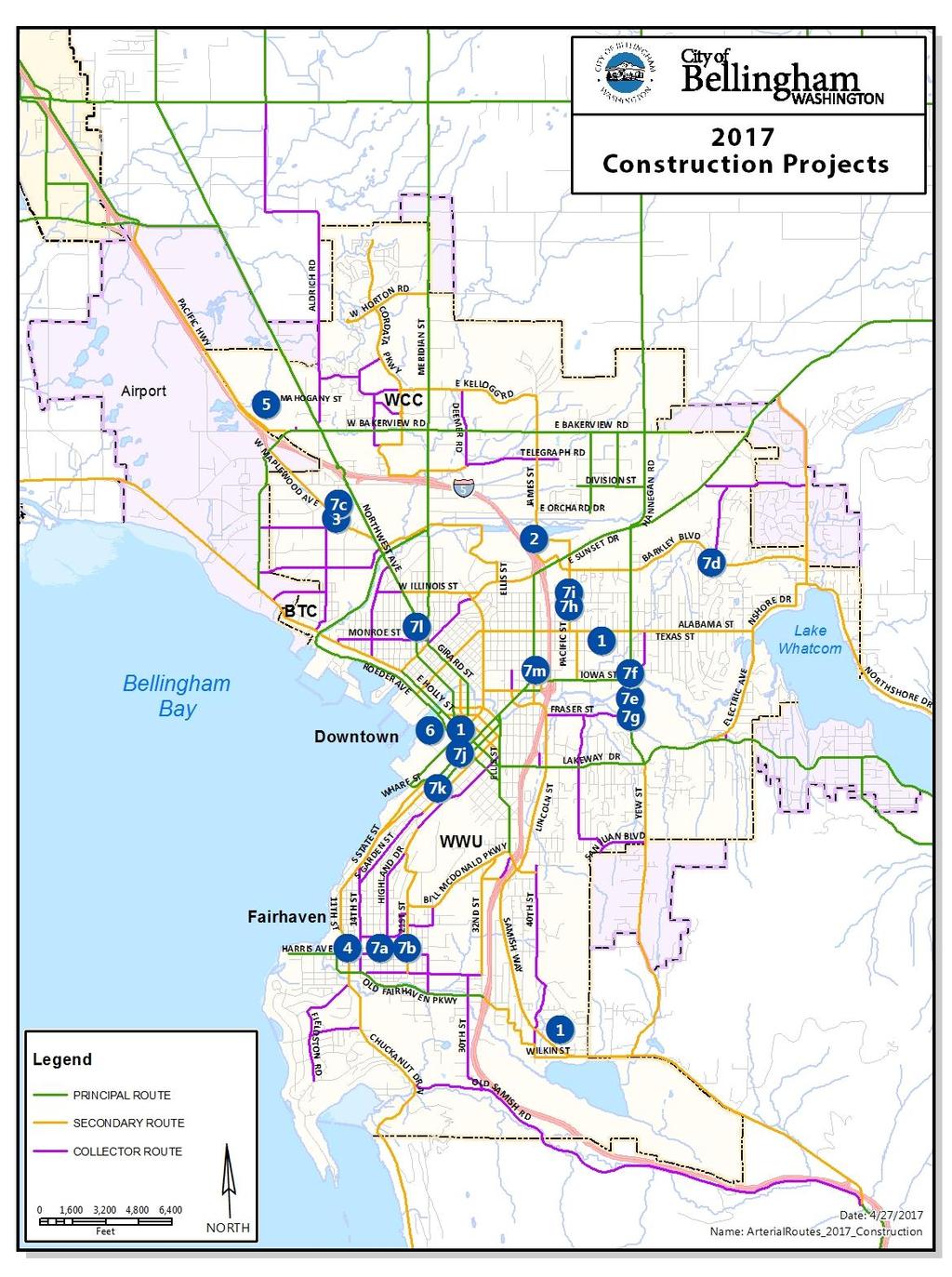
5 FUNDING Previous FUNDED No. PROJECT DESCRIPTION SOURCE Budget Street TBD Resurface 2 James-Woodstock Federal STP 1,850 Build Intersection Reconstruction Subtotal 1,850 West Maplew ood Avenue TBD Resurface Multimodal Improvements TBD Non-Motor (Sidew alk, bike lanes, resurfacing) Federal SRTS 895 Build Subtotal 2,160 1,140 12th Street Sidew alk and TBD Non-Motor Multimodal Improvements State TIB 300 Build (12th/Mill in Fairhaven) Private Mitigation 150 Subtotal Mahogany Avenue Street Multimodal Arterial TBD Non-Motor East-West arterial access betw een Federal STP / Map 21 2,650 Northw est Ave to Pacific Highw ay State TIB (UAP + CS) 2,750 Sew er-water-storm 2,000 Subtotal 5,750 2,750 8,500 Granary Avenue-Laurel Street Street 1,000 6 (Roeder Ave to Cornw all Ave) Federal 8,200 7 a) Tier 1 b) Tier 1 c) Tier 3 d) Tier 1 e) Tier 2 f) n/a g) Tier 1 h) Tier 2 i) Tier 1 j) Tier 1 k) n/a l) n/a 1 m) n/a Transportation Projects Under Construction (Not Included in TIP) Arterial Street Resurfacing Holly Street (Railroad Avenue to Bay Street) Texas Street (Pacific Street to Valencia Street) Harrison Avenue (40th Street to Haw k Way) Non-Motorized (Pedestrian & Bicycle) Projects County EDI 1,100 Subtotal 10,300 10,300 Woburn Street Bike Lanes (Texas St to Lakew ay Drive) Parking Removed West Side Woburn/Kentucky Pedestrian Safety Improvements - Sidew alk West Side; Marked Crossw alk Woburn/Fraser Pedestrian Safety Improvements - Flashing Crossw alk Installed Orleans Street Bike lanes (Sunset Drive to Alabama Street) Parking Removed One Side Build Build Mill Avenue Bike Blvd (10th Street to 24th Street) - Bicycle Shared Lane Markings & Wayfinding Mill Ave/21st St Pedestran Safety Improvements - ADA ramps & Marked Crossw alks Alderw ood Ave Bike Blvd (Northw est Avenue to Bennett Drive) Bicycle Shared Lane Markings Barkley Blvd Bike Lanes (Woburn St to Britton Rd) Enhancement to Substandard Bike Lanes Orleans/Illinois Pedestrian & Bicycle Safety Improvements - Curb Extensions; Marked Crossw alks State Street marked bike lane enhanced to Buffered Bike Lane (York St to Wharf Roundabout) Forest Street lane reduction, parking installation, and Buffered Bike Lane (S. State St to Rose St) Bicycle Wayfinding on Prospect-Dupont-Elm-Northw est Avenue (Dow ntow n to north City limit) Bicycle Wayfinding on Young-Kentucky-Nevada-Texas-Michigan (Dow ntow n to Barkley Village)
6
7 Transportation Improvement Projects (Fund Page 1) Cost Estimates (000's) 2017 Dollars FUNDING Previous FUNDED UNFUNDED PROJECT No. PROJECT DESCRIPTION SOURCE Budget TOTALS Annual Arterial Street Street 1,425 1,320 1,465 2,515 2,565 2,600 2,640 1 Pavement Resurfacing 1,2,3 TBD Resurface 1,500 2,000 2,315 2,650 1) Increase annual sales tax % Subtotal 2,925 3,320 3,780 5,165 2,565 2,600 2,640 22,995 Nonmotorized Transport 1,2,3 TBD Non-Motor 1,110 1, ,400 2 Sidew alk & Bikew ay Improvements 10% Grant Reserve ) Current TBD expires 12/31/2020 Subtotal 1,110 1,300 1,100 2,650 6,160 Cordata/Stuart Roundabout Street Public-Private Partnership State TIB 1,500 Build (WCC & Private Development) Private Mitigation 300 Subtotal 1, ,100 Cordata Safe Route to School TBD Resurface 200 [Aldrich Road - Cordata ES] TBD Non-Motor (Sidew alk, bike lane east side Aldrich) BSD 75 Federal SRTS 778 Build Subtotal 778 1,175 1,953 Lakew ay Drive and Lincoln Street 10% Grant Reserve Pedestrian - Bicycle Safety & Mobility WSDOT Ped-Bike 1,250 Build (HAWK signals, sidew alks, bike blvds) Subtotal 1,500 1,500 Orchard Drive Extension Street Multimodal Grade-Separated Federal STP-R 1,250 Build Crossing of Interstate 5 WSDOT Gas Tax 10,000 (Birchw ood/squalicum to James St) Subtotal 2,114 10,000 12,114 West Horton Road Multimodal Street 1, Corridor Improvements-Phase 1 TBD Non-Motor (Current terminus to Aldrich Road) Private Mitigation Federal STP/Map ,300 Build Subtotal 1,312 3,200 1,100 5,612 Telegraph Road Multimodal Street Safety Improvements TBD Non-Motor 250 1,000 8 (James Street to Deemer Road) Private Mitigation WTA 62 Federal STBG State TIB UAP & CS Unknow n 3,850 Subtotal ,427 3,850 5,842 Northw est Ave / Bakerview Rd. Street 75 9 Intersection Safety Improvements Unknow n 4,000 (Multimodal Roundabout) Subtotal 75 4,000 4,075 James/Bakerview Intersection Street Safety Improvements Federal STP 385 (Expandable roundabout) Unknow n 3,300 Subtotal 505 3,300 3,805
8 Transportation Improvement Projects (Fund Page 2) Cost Estimates (000's) 2017 Dollars FUNDING Previous FUNDED UNFUNDED PROJECT No. PROJECT DESCRIPTION SOURCE Budget TOTALS Ellis Street Bridge Reconstruction Street (Ellis - N. State Intersection) TBD Resurface Federal BRAC 2,740 Subtotal ,740 3, Bellingham Railroad Quiet Zones 1st 1/4 REET Subtotal ,000 Samish-Maple-Ellis Corridor Street Multimodal Safety Improvements TBD Non-Motor (Bill McDonald Pkw y to Lakew ay Drive) Unknow n 3,000 Subtotal 3,000 3,000 Meridian/Birchw ood/squalicum Street Intersection Safety Improvements Unknow n 7,000 (Safety & Feasibility Study) Subtotal 50 James Street Multimodal Street Safety Improvements Pvt Mitigation (E. Orchard to Bakerview ) Unknow n 7,000 Subtotal 7,000 7,000 North James Street Pvt Mitigation 16 Multimodal Arterial Connection Unknow n 6,000 (Gooding to Van Wyck) Subtotal 6,000 6,000 West Horton Road Multimodal Federal Map 21 1,000 Corrdor Extension, Phase 2 County Road Fund [City-County Partnership] Pvt Mitigation 1,000 (Aldrich to Northw est) Unknow n 10,000 Subtotal 1,260 1,000 10,000 12, TIP PROJECT FUNDING SOURCE SUMMARIES Cost Estimates (000's) 2017 Dollars Previous FUNDED UNFUNDED FUNDING SOURCES Budget TOTALS STREET FUNDS 2,834 2,620 2,440 2,515 2,565 2,600 2,640 18,214 TRANSPORTATION BENEFIT DISTRICT - Resurfacing 1,500 2,200 2,600 2, ,950 TRANSPORTATION BENEFIT DISTRICT - Nonmotorized 1,610 2,500 2,600 2, ,360 1st & 2nd QUARTER REET FUNDS ,000 STATE FUNDS (TIB, WSDOT, Gas Tax, WWU, WCC, etc) 2, , ,750 FEDERAL FUNDS (STP, SR2S, HSIP, etc) 2,913 2, ,213 PRIVATE MITIGATION FUNDS 1, ,667 OTHER (Parks, Port, County, EDI, WTA, etc) UNKNOWN FUNDS ,890 14,000 16,000 46,890 TOTAL TIP FUNDS 13,019 10,595 18,005 8,065 19,455 16,600 18, ,379
9

 with the specific purpose of using TBD revenue to supplement the City Street")
10 Project #1: Annual Arterial Pavement Resurfacing Program (Goal: 5% of Arterial Street Network Per Year) PROJECT NARRATIVE: Annual maintenance of existing arterial streets and bicycle lanes to protect the City s investment in these facilities and to ensure an adequate quality driving and riding surface at an optimized life-cycle cost. Presuming a 20-year life cycle, approximately 5% of the City s arterial streets require resurfacing each year, but that goal has not been achieved due to funding shortfalls. In November 2010, Proposition 1 was approved by Bellingham voters to establish a Transportation Benefit District (TBD) with the specific purpose of using TBD revenue to supplement the City Street Fund for arterial resurfacing through the year MULTIMODAL TRANSPORTATION BENEFITS: Automobiles represent the dominant mode choice of travelers on the multimodal transportation network, but adding bicycle lanes, sidewalks, curb extensions, and crosswalks (where possible) when arterial pavement resurfacing occurs, also helps to expand and enhance the citywide pedestrian, bicycle, and WTA transit networks and increases safety for all users. Cost Estimates (000's) 2017 Dollars FUNDING Previous FUNDED UNFUNDED PROJECT No. PROJECT DESCRIPTION SOURCE Budget TOTALS Annual Arterial Street Street 1,425 1,320 1,465 2,515 2,565 2,600 2,640 1 Pavement Resurfacing 1,2,3 TBD Resurface 1,500 2,000 2,315 2,650 1) Increase annual sales tax % Subtotal 2,925 3,320 3,780 5,165 2,565 2,600 2,640 22,995 Arterial Street Maintenance Not Eligible No PROJECT STATUS: Annual program, ; Goal 5% of arterial street network per year
11 Project #2: Non-Motorized Transportation Improvements PROJECT NARRATIVE: In November 2010, Proposition 1 was approved by Bellingham voters to establish a Transportation Benefit District (TBD) with the specific purpose of funding arterial resurfacing, transit, and non-motorized improvements in Bellingham. Non-motorized improvements are primarily prioritized through the Pedestrian and Bicycle Master Plans, but also through grant funding opportunities and other capital improvement needs, such as those of WTA for public transit. Non-motorized funding is provided by revenue from the TBD through the 1 st quarter of MULTIMODAL TRANSPORTATION BENEFITS: Additional sidewalk connections, crosswalks, and various bicycle facilities will help to complete and enhance the citywide Pedestrian and Bicycle nonmotorized transportation network and the WTA transit network throughout Bellingham. PROJECT STATUS: The TBD Board meets quarterly to discuss the status of TBD funds, projects in construction and/or design/engineering, and possible future projects. FUNDING Previous FUNDED UNFUNDED PROJECT No. PROJECT DESCRIPTION SOURCE Budget TOTALS Nonmotorized Transport 1,2,3 TBD Non-Motor 1,110 1, ,400 2 Sidew alk & Bikew ay Improvements 10% Grant Reserve Cost Estimates (000's) 2017 Dollars 3) Current TBD expires 12/31/2020 Subtotal 1,110 1,300 1,100 2,650 6,160 Yes, citywide Complete Networks Undetermined Recommended TBD Nonmotorized Improvements Cost-Estimate 1 PE/Construction 2018 Reserve 10% Non-motorized Fund Local Match for Grant applications $250, Grant Applications 2.a. Aldrich Road sidewalk (P1) and bike lane (B1) (east side) $650,000 Design 2017-Build b. Otis/Maple Amber Flashing Crosswalk & Bike Blvd (B1) $400,000 Design 2017-Build c. Undine St Sidewalk (P1) and Bike Blvd (B2) $700,000 Design 2017-Build d. West Horton Sidewalks (P1) and Bike Lanes (B3) $300,000 Design 2017-Build e. St. Paul Bike Blvd (B1) $100,000 Design 2017-Build f. Various Bike Blvds and Bike Lanes as funding allows $100,000 Design 2017-Build ,500, Reserve 10% Non-motorized Fund Local Match for Grants $250, Grant Applications 2.g. West Horton Sidewalks (P1) and Bike Lanes (B3) $500,000 Design 2018-Build h. Telegraph Road Sidewalks (P3) and Bike Lanes (B3) $1,000,000 Design 2018-Build ii. Lakeway Bike Lane (B2) and Old Lakeway Bike Blvd (B2) $750,000 Design 2018-Build j. Various Bike Blvds and Bike Lanes as funding allows $100,000 Design 2018-Build 2019 $2,600,000 Notes: 1.) Preliminary estimates of project costs are primarily from Pedestrian and Bicycle Master Plans 2.) P 1, 2, 3 and B 1, 2, 3 refers to Tier 1, 2, or 3 scores in the Pedestrian and Bicycle Master Plans
12 Project #2: Non-Motorized Transportation Improvements 2018 Recommended TBD Nonmotorized Improvements Cost-Estimate 1 PE/Construction 2.a. Aldrich Road sidewalk (P1) and bike lane (B1) (east side) $650,000 Design 2017-Build 2018 Tier 1 sidewalk and Tier 1 Bike Lane east side of Aldrich Road (See TIP Project #4). Possible future WTA transit service route. 2.b. Otis/Maple Amber Flashing Crosswalk & Bike Blvd (B1) $400,000 Design 2017-Build 2018 Install amber flashing crosswalk at Otis/Maple in support of rerouted Tier 2 Bike Boulevard across N. Samish Way and Bellingham Housing Authority redevelopment of Aloha Motel site for affordable housing (Integrated with TIP Project #5 and TIP Project #13). Serves WTA transit route 107 and c. Undine St Sidewalk (P1) and Bike Blvd (B2) $700,000 Design 2017-Build 2018 Tier 1 sidewalk east side of Undine connecting to pedestrian hybrid beacon (HAWK) signal constructed at Alabama/Undine in This Tier 2 Bike Boulevard will connect to the multiuse Railroad Trail and the Tier 1 Kentucky/Nevada/Texas Bike Boulevard. Bicycle wayfinding signs and street markings will be installed with all of these connections. Serves WTA transit route d. West Horton Sidewalks (P1) and Bike Lanes (B3) $300,000 Design 2017-Build 2018 Tier 1 sidewalk and Tier 3 Bike Lane both sides of West Horton Road (See TIP Project #7). Possible future WTA transit service route. 2.e. St. Paul Bike Blvd (B1) $100,000 Design 2017-Build 2018 Tier 2 Bike Boulevard on St. Paul connecting to pedestrian hybrid beacon (HAWK) signal constructed at Alabama/St. Paul in This Tier 2 Bike Boulevard will connect to the multiuse Railroad Trail and the Tier 1 Kentucky/Nevada/Texas Bike Boulevard. Bicycle wayfinding signs and street markings will be installed with all of these connections. Serves WTA transit route 331 and f. Various Bike Blvds and Bike Lanes, as TBD funding allows $100,000 Design 2017-Build Recommended TBD Nonmotorized Improvements Cost-Estimate 1 PE/Construction 2.g. West Horton Sidewalks (P1) and Bike Lanes (B3) $500,000 Design 2018-Build 2019 Tier 1 sidewalk and Tier 3 Bike Lane both sides of West Horton Road (See TIP Project #7). Possible future WTA transit service route. 2.h. Telegraph Road Sidewalks (P3) and Bike Lanes (B3) $1,000,000 Design 2018-Build 2019 Tier 3 sidewalks and Tier 3 Bike Lane both sides of Telegraph Road (See TIP Project #8) to support significant multifamily and affordable housing in King Mountain Neighborhood and WTA Gold GO Line (Route 331) to allow transit riders to walk and bike to WTA bus stops. 2.ii. Lakeway Bike Lane (B2) and Old Lakeway Bike Blvd (B2) $750,000 Design 2018-Build 2019 As a result of the Tier 1 Lakeway Drive Bikeway Study, Phase 1 recommendations are to install a Tier 2 Bike Boulevard on Old Lakeway Drive between Yew Street and Lakeway Drive and a Tier 2 protected 2-way bike lane between Old Lakeway and the new Tier 1 pedestrian HAWK crossing (See TIP Project #5) between Undine and Toledo. Tier 2 marked bike lanes can be installed on Lakeway from the HAWK to Puget for interim connectivity benefit until funding is available for protected bike lanes. 2.j. Various Bike Blvds and Bike Lanes, as TBD funding allows $100,000 Design 2018-Build 2019 Notes: 1.) Preliminary estimates of project costs are primarily from Pedestrian and Bicycle Master Plans 2.) P 1, 2, 3 and B 1, 2, 3 refers to Tier 1, 2, or 3 scores in the Pedestrian and Bicycle Master Plans
.")

13 Project #3: Cordata/Stuart Intersection Safety Improvements PROJECT NARRATIVE: Cordata Parkway is the major north-south secondary arterial through the Cordata Neighborhood and Stuart Road provides east-west access to Whatcom Community College (WCC). Development is proposed on all four corners and the Parks Department purchased 27 acres for a regional park on the northeast side of this intersection. Intersection operations are approaching the LOS E/F threshold and left-turns from Stuart to Cordata have become difficult. A multimodal roundabout will slow vehicles, reduce collisions, and improve safety for all transportation users as the Cordata Neighborhood continues to develop over time. Tier 3 intersection crossing improvement. MULTIMODAL TRANSPORTATION BENEFITS: Tier 1 crosswalks with pedestrian refuges, Tier 3 bikeways, vehicle collision reduction, increased safety & efficiency of freight and goods movement, and WTA Transit Route 24. PROJECT STATUS: TIB grant received, private mitigation contribution required Cordata/Stuart Roundabout Street Public-Private Partnership State TIB 1,500 Build (WCC & Private Development) Private Mitigation 300 Subtotal 1, ,100 Yes, for local funds Yes


14 Project #4: Cordata Safe Route to School (Mahogany Avenue to Cordata ES) PROJECT NARRATIVE: Aldrich Road is an old rural standard County road that was annexed to the City in Cordata Elementary School was opened on Aldrich Road in 2011, but school children, staff, and visitors cannot walk or bike to school because there are not complete sidewalks on Aldrich. A private developer constructed sections of sidewalk and bike lane on the east side of Aldrich Road in 2013 as mitigation requirements for a large multifamily complex, but significant gaps remain in the sidewalk and bike lane. There is no sidewalk or bike lane on the west side of Aldrich. This Safe Route to School project will fill the Tier 1 sidewalk and Tier 1 bike lane gaps on the east side of Aldrich, install flashing 20 mph school zone signs, and improve street lighting. Mitigation will be required for impacts to environmental features (wetlands, streams). MULTIMODAL TRANSPORTATION BENEFITS: Sidewalk, bicycle lane, school zone, street lighting, possible future WTA transit route as W. Horton Road and MF & SF developments are completed. PROJECT STATUS: Funded. PE-Design-ROW Construction Cordata Safe Route to School TBD Resurface 200 [Aldrich Road - Cordata ES] TBD Non-Motor (Sidew alk, bike lane east side Aldrich) BSD 75 Federal SRTS 778 Build Subtotal 1, ,953 Yes, for local funds Probable


15 Project #5: Lakeway & Lincoln Pedestrian and Bicycle Safety and Mobility Improvements PROJECT NARRATIVE: Upgrade existing amber flashing crosswalks to pedestrian hybrid beacon (HAWK) signals at Lakeway/Grant, Lakeway/Ellis, and Lincoln/Fred Meyer and construct a new HAWK signal near Lakeway/Toledo, which is a Tier 1 crossing in the Pedestrian Master Plan. Tier 1 sidewalk on the east side of Nevada Street from Lakeway to Thimbleberry and Tier 2 sidewalk on the west side of Orleans from Lakeway to Potter. Tier 1 bike boulevard 34 th /Otis/Humboldt/Grant/Humboldt and Tier 2 bike boulevard 40 th /Dumas/Ashley/Byron/44 th /Nevada. MULTIMODAL TRANSPORTATION BENEFITS: Access, safety, connectivity for school children, pedestrians, bicyclists, vehicles, freight trucks, & WTA high-frequency Plum GO Line transit riders. PROJECT STATUS: Grant pending June 2017; PE & Design 2017; construction anticipated Lakeway Drive and Lincoln Street 10% Grant Reserve Pedestrian - Bicycle Safety & Mobility WSDOT Ped-Bike 1,250 Build (HAWK signals, sidew alks, bike blvds) Subtotal 1,500 1,500 Yes, if local public funds are used No
, through the railroad tunnel beneath Interstate 5, to James/Orchard north of Sunset Pond Park This new east-west arterial will enhance regional")
16 Project #6: Orchard Drive Extension Multimodal Grade-Separated Crossing of I-5 PROJECT NARRATIVE: Construct a multimodal arterial from the corner of Birchwood Avenue/Squalicum Parkway generally along the former railroad bed (north of Bug Lake), through the railroad tunnel beneath Interstate 5, to James/Orchard north of Sunset Pond Park This new east-west arterial will enhance regional transportation circulation for all modes between rapidly-growing northern Bellingham, St Joseph s Hospital, and central Bellingham. Construction of this arterial street will ease pressure on the Interstate interchanges at Meridian and Sunset and is the last opportunity for a gradeseparated crossing of Interstate 5 in Bellingham. The WA legislature has allocated $10 million in Connecting Washington gas tax funds for this important regional connection. MULTIMODAL TRANSPORTATION BENEFITS: Tier 3 sidewalk north side, Tier 1 bicycle lanes both sides, off-street multi-use Bay-to-Baker trail, improved emergency response time to St Joseph hospital, Tier 3 grade-separated multimodal crossing of Interstate 5, and possible future WTA transit route,. PROJECT STATUS: Funded. 90% design engineering 2017; Squalicum Re-route completed 2015; Bay to Baker Trail completed Orchard Drive construction anticipated Orchard Drive Extension Street Multimodal Grade-Separated Federal STP-R 1,250 Build Crossing of Interstate 5 WSDOT Gas Tax 10,000 (Birchw ood/squalicum to James St) Subtotal 2,114 10,000 12,114 Yes for local funds Yes


17 Project #7: West Horton Road Multimodal Corridor Extension, Phase 1 (Horton terminus to Aldrich Road) PROJECT NARRATIVE: Regional growth and development and the 30-acre Cordata Park with parking access from Horton requires that West Horton Road be extended as a secondary arterial street with Tier 1 sidewalks and Tier 1 bicycle lanes on both sides from the current terminus to Aldrich Road. Environmental impacts require land acquisition, off-site mitigation, and attempts to minimize the road prism footprint. Dedicated left-turn lanes will be needed at the intersection of W. Horton/Aldrich. MULTIMODAL TRANSPORTATION BENEFITS: Access, safety, connectivity for school children, pedestrians, park and trail users, bicyclists, vehicles, freight trucks, & possible future WTA transit route. PROJECT STATUS: Feasibility studies, wetland delineations, & survey completed ; land acquisition & mitigation planning ; 60% PE & Design 2016; construction anticipated West Horton Road Multimodal Street 1, Corridor Improvements-Phase 1 TBD Non-Motor (Current terminus to Aldrich Road) Private Mitigation Federal STP/Map ,300 Build Subtotal 1,312 3,200 1,100 5,612 Yes, if local public funds are used No


18 Project #8: Telegraph Road Multimodal Safety Improvements (James Street to Deemer Road) PROJECT NARRATIVE: Telegraph Road has seen a significant increase in vehicle traffic, as well as pedestrian, bicycle, and transit demand, as a result of annexations, growth, and development of commercial retail and multifamily housing. Vacant land along Telegraph Road is zoned for more highdensity housing units and there are several development projects in plan review and permitting stages. Pedestrian and Bicycle Master Plans call for sidewalks and bike lanes on Telegraph Road and WTA rerouted the high-frequency Gold GO Line to James Street-Telegraph Road-Deemer Road in March MULTIMODAL TRANSPORTATION BENEFITS: Tier 3 sidewalks, Tier 3 bicycle lanes, pedestrian crossing, center turn lane, access management, safety, LED street lights, traffic signals, and transit shelters for WTA Gold GO Line (Route 331). PROJECT STATUS: Unfunded. State & federal grants as well as private & WTA funding will be sought. Telegraph Road Multimodal Street Safety Improvements TBD Non-Motor 250 1,000 8 (James Street to Deemer Road) Private Mitigation WTA 62 Federal STBG State TIB UAP & CS Unknow n 3,850 Subtotal ,427 3,850 5,842 Yes, if local funds are used Yes


19 Project #9: Northwest/W. Bakerview Intersection Safety Improvements PROJECT NARRATIVE From , over 150 vehicle collisions were recorded at the Northwest/Bakerview intersection. This high collision rate is likely to continue as more development occurs in northwest Bellingham in the future unless safety countermeasures can be installed or improvements made to the intersection. The nearby intersection of Northwest/Aldrich may also require a new northbound drop/right-turn lane from West Bakerview Road to Aldrich Road to enhance safety, reduce existing traffic congestion, and accommodate additional infill development in the Bakerview corridor. A feasibility study was conducted in and both short-term and long-term safety countermeasures have been identified for these intersections. MULTIMODAL TRANSPORTATION BENEFITS Tier 3 sidewalk, Tier 3 bikeways, collision reduction, improved safety, reduced congestion, regional circulation benefits, safety and on-time performance for WTA transit routes 3, 4, 27, 55, and 232. PROJECT STATUS: Feasibility study ; Construction unfunded. Northwest Ave / Bakerview Rd. Street 75 9 Intersection Safety Improvements Unknow n 4,000 Subtotal 75 4,000 4,075 Yes, if local public funds are used Possibly

20 Project #10: James/Bakerview Intersection Safety Improvements PROJECT NARRATIVE: East Bakerview Road is a major arterial and trucking route between the Irongate industrial area, SR 539, and I-5. James Street is the only north-south secondary arterial between Sunset Drive and Kellogg Road. Increased traffic and lack of north-south left-turn lanes contribute to an increase in speeding and collisions at the James/Bakerview intersection. Constructing an expandable multimodal roundabout will slow speeding vehicles, reduce collisions, and improve safety for all users, while also providing long-term transportation capacity, as the King Mountain area develops. MULTIMODAL TRANSPORTATION BENEFITS: Tier 3 sidewalks, crosswalk with pedestrian refuges, Tier 3 bicycle lanes, collision reduction, increased safety & efficiency of freight and goods movement, WTA transit route 48 and possible future WTA transit routes as ridership demand increases. PROJECT STATUS: 90% engineering and design ; TIB grant secured; other grant being sought; construction pending full funding. James/Bakerview Intersection Street Safety Improvements Federal STP 385 (Expandable roundabout) Unknow n 3,300 Subtotal 505 3,300 3,805 Yes, for local funds Yes
 PROJECT NARRATIVE The existing bridge was constructed in 1940 and has experienced major substructure deterioration.")

21 Project #11: Ellis Street Bridge Reconstruction (Ellis Street/N. State Street Intersection) PROJECT NARRATIVE The existing bridge was constructed in 1940 and has experienced major substructure deterioration. Major repairs were made in the year 2000 when new pilings were driven in, but the overall deterioration has continued. Temporary shoring allows the bridge to remain open, but reconstruction of the bridge is necessary in the near future. Federal BRAC grant funding for construction has been applied for with funding awards anticipated for Autumn Local funding is programmed here for preliminary engineering, design, and local matching fund requirements for the BRAC grant., which would allow construction to occur in MULTIMODAL TRANSPORTATION BENEFITS Sidewalks, bikeways, PROJECT STATUS: Unfunded; Federal BRAC grant funding application pending. Cost Estimates (000's) 2017 Dollars FUNDING Previous FUNDED UNFUNDED PROJECT No. PROJECT DESCRIPTION SOURCE Budget TOTALS Ellis Street Bridge Reconstruction Street (Ellis - N. State Intersection) TBD Resurface Federal BRAC Pending 2,740 Subtotal 400 3,025 3,425 Yes, if local public funds are used No
 railroad tracks on the Bayview Drive vehicular entrance into Boulevard Park.")

22 Project #12: BNSF Railroad Quiet Zone (Boulevard Park at-grade street/rail crossing ) PROJECT NARRATIVE: The City of Bellingham will examine the possibility of making significant safety improvements for the at-grade street crossing of the Burlington Northern Sante Fe (BNSF) railroad tracks on the Bayview Drive vehicular entrance into Boulevard Park. If safety improvements can be made that meet BNSF and federal guidelines, then a Railroad Quiet Zone may be established that would allow train engineers not to blow train horns unless there was an emergency. Several different types of at-grade crossing improvements can be used, depending on the circumstances and needs of the specific site. Preliminary cost estimates are approximately $500,000 to $750,000 per at-grade crossing, depending on the improvements made. MULTIMODAL TRANSPORTATION BENEFITS: ADA-compliant surface crossing of railroad tracks and reduction of vehicle/rail conflicts. PROJECT STATUS: REET funding identified as most-appropriate for these improvements. Cost Estimates (000's) 2017 Dollars FUNDING Previous FUNDED UNFUNDED PROJECT No. PROJECT DESCRIPTION SOURCE Budget TOTALS 12 Bellingham Railroad Quiet Zones 1st 1/4 REET Subtotal ,000 No No


23 Project #13: Samish-Maple-Ellis Corridor Pedestrian and Bicycle Safety Improvements PROJECT NARRATIVE: Rechannelize the Samish-Maple-Ellis corridor to install on-street parking and a protected bike lane along the east side, a buffered bike lane on the west side, a new pedestrianactivated flashing crosswalk at Otis/Maple, and where possible, driveway consolidation to reduce turning movement conflicts for pedestrians and bicyclists. Tier 2 bike lanes on Samish Way will be integrated with the 2018 Tier 1 bike boulevard along 34 th /Otis/Humboldt/Grant/Humboldt and Tier 2 bike boulevard 40 th /Dumas/Ashley/Byron/44 th /Nevada (See Project #5 Lakeway-Lincoln Pedestrian-Bicycle Safety) MULTIMODAL TRANSPORTATION BENEFITS: Access, safety, connectivity for pedestrians, bicyclists, vehicles, freight trucks, & WTA transit riders on routes 107 & 108. PROJECT STATUS: Unfunded; State grant funding sought Samish-Maple-Ellis Corridor Street Pedestrian and Bicycle Safety TBD Non-Motor Improvements Unknow n 3,000 (Bill McDonald to Lakew ay Drive) Subtotal 3,000 3,000 Yes, if local public funds are used No
 and Hannegan, which is already zoned for up to 2,000 new housing units.")

24 Project #14: James Street Multimodal Safety Improvements (East Orchard Drive to East Bakerview Road) PROJECT NARRATIVE: James Street is the only north- south transportation corridor serving northcentral Bellingham between Meridian (SR 539) and Hannegan, which is already zoned for up to 2,000 new housing units. James Street also provides access to Sunset Pond Park between Sunset and East Bakerview. A vertical curve on the hill between Orchard and McLeod may require elimination of a sight distance issue, but more investigation is required. Pedestrian and Bicycle Master Plans call for sidewalks and bike lanes on James Street and WTA rerouted the high-frequency Gold GO Line Route 331 to travel on James Street-Telegraph Road-Deemer Road in both directions in March MULTIMODAL TRANSPORTATION BENEFITS: Tier 3 sidewalks, Tier 3 bicycle lanes, turn lanes, increased access, safety, sight distance, and efficiency. WTA Gold GO Line high-frequency transit route 331 in 2017 and possible future WTA transit routes as King Mountain Neighborhood develops.. PROJECT STATUS: Unfunded. State and federal grant funding will be sought. James Street Multimodal Street Safety Improvements Pvt Mitigation (E. Orchard to Bakerview ) Unknow n 7,000 Subtotal 7,000 7,000 Yes, if local funds are used Unknown

25 Project #15: North James Street Multimodal Arterial Connection (Gooding Avenue to Van Wyck Road) PROJECT NARRATIVE: James Street currently terminates at Gooding Avenue, but the Transportation Element of the Bellingham Comprehensive Plan identifies the need for James to be extended north to Van Wyck Road as a full standard secondary arterial. James Street is the only north- south transportation corridor serving north-central Bellingham between Meridian (SR 539) and Hannegan, which is already zoned for up to 2,000 new housing units. In addition to supporting the development planned for the King Mountain Neighborhood, this northern extension of James Street will provide another north-south corridor parallel to Meridian (SR 539), which will help to ease some of the northbound evening and weekend traffic congestion. MULTIMODAL TRANSPORTATION BENEFITS: Tier 3 sidewalks, Tier 3 bike lanes, center turn lanes at intersections, regional multimodal transportation connectivity, and possible future WTA transit route. PROJECT STATUS: Private developer constructed first phase in 2014 with King Mountain subdivision North James Street Pvt Mitigation 15 Multimodal Arterial Connection Unknow n 6,000 (Gooding to Van Wyck) Subtotal 6,000 6,000 Yes, if local public funds are used? Yes, private development to dedicate


26 Project #16: West Horton Road Multimodal Corridor Extension, Phase 2 (Aldrich Road to Northwest Avenue) PROJECT NARRATIVE: City County partnership to extend an east-west regional transportation connection in northern Bellingham. Phase 2 extends West Horton for one-half mile west as an arterial street with sidewalks and bicycle lanes on both sides from Aldrich Road to Northwest Avenue. Environmental impacts require land acquisition, off-site mitigation, and minimizing the road footprint. MULTIMODAL TRANSPORTATION BENEFITS: Increased access, safety, and connectivity for pedestrians, bicyclists, transit riders, and vehicles. Tier 1 sidewalks, Tier 1 bike lanes, possible future WTA transit route as W. Horton Road, annexations, and MF & SF developments are completed. PROJECT STATUS: Feasibility studies, wetland delineations, & survey: 2017; land acquisition & mitigation planning ; PE & Design ; additional funding being sought. West Horton Road Multimodal Federal Map 21 1,000 Corrdor Extension, Phase 2 County Road Fund [City-County Partnership] Pvt Mitigation 1,000 (Aldrich to Northw est) Unknow n 10,000 Subtotal 1,260 1,000 10,000 12,260 Yes, if local public funds are used Yes
Six-Year ( ) Transportation Improvement Program (TIP)
 Transportation Improvement Program (TIP)") Six-Year (2017-2022) Transportation Improvement Program (TIP) Kelli Linville, Mayor Ted Carlson, Public Works Director City Council Members Pinky Vargas - 4th Ward, Council President Roxanne Murphy - At
Six-Year (2017-2022) Transportation Improvement Program (TIP) Kelli Linville, Mayor Ted Carlson, Public Works Director City Council Members Pinky Vargas - 4th Ward, Council President Roxanne Murphy - At
Supplemental Information for DRAFT TIP
 City of Bellingham Public Works Department Supplemental Information for DRAFT 2016-2021 TIP The following pages are intended to provide supplemental information and explanation of the rationale for projects
Samish-Maple-Ellis Corridor Pedestrian & Bicycle Safety Improvements. Bellingham City Council March 26, 2018
 1 Samish-Maple-Ellis Corridor Pedestrian & Bicycle Safety Improvements Bellingham City Council March 26, 2018 2009 Samish Way Urban Village Street Plans Multiple Plans Adopted by City Council 2009 Samish
Changing the Climate of Mobility: Bellingham s Multimodal Transportation Networks
 1 Changing the Climate of Mobility: Bellingham s Multimodal Transportation Networks Presented by: Chris Comeau, Transportation Planner, Public Works Climate Action Task Force March 6, 2019 2 Bellingham
Transportation Report on Annual Mobility
 Transportation Report on Annual Mobility Published annually in support of: Comprehensive Plan Transportation Element Multimodal Transportation Concurrency Program Transportation Benefit District No. 1
Transportation Report on Annual Mobility
 Transportation Report on Annual Mobility Published annually in support of: Comprehensive Plan Transportation Element Multimodal Transportation Concurrency Program Transportation Benefit District No. 1
2018 Pedestrian and Bicycle and Safe Routes to School Application for Funding Page 1 of 31
 2018 Pedestrian and Bicycle and Safe Routes to School Application for Funding Page 1 of 31 2018 Pedestrian and Bicycle and Safe Routes to School Application for Funding Part 1: General Information Funding
Transportation Report on Annual Mobility
 Transportation Report on Annual Mobility Published annually in support of Bellingham s: Comprehensive Plan Transportation Element; Multimodal Transportation Concurrency Program; Complete Networks Policies;
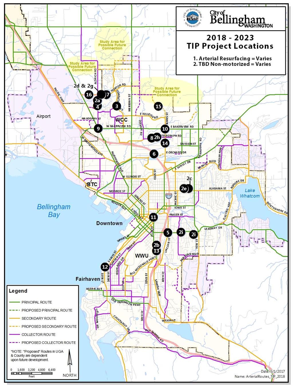
Multi-Modal Transportation Improvement Projects Identified by Neighborhood for the 20-year Planning Period
 2011 CITY CENTER MASTER PLAN UPDATE ADOPTED TRANSPORTATION ELEMENT PROJECT LIST FOR THE CBD, WATERFRONT, AND YORK, SEHOME, AND LETTERED STREETS NEIGHBORHOODS IMMEDIATELY ADJACENT TO CITY CENTER TRANSPORTATION
Proposed. City of Grand Junction Complete Streets Policy. Exhibit 10
 Proposed City of Grand Junction Complete Streets Policy Exhibit 10 1 City of Grand Junction Complete Streets Policy Vision: The Complete Streets Vision is to develop a safe, efficient, and reliable travel
Chapter 2. Bellingham Bicycle Master Plan Chapter 2: Policies and Actions
 Chapter 2 Bellingham Bicycle Master Plan Chapter 2: Policies and Actions Chapter 2: Policies and Actions The Bicycle Master Plan provides a road map for making bicycling in Bellingham a viable transportation
Alabama Street Corridor. Road Diet Feasibility Study & Safety Improvements
 Alabama Street Corridor Road Diet Feasibility Study & Safety Improvements Chris Comeau, AICP, Transportation Planner Bellingham Public Works (360) 778-7946 10/28/2011 Bellingham adhered to the following
Chapter 3: Bicycle Network Recommendations
 Chapter 3: Bicycle Network Recommendations Chapter 3 presents the recommended network of on-street bicycle facilities that will help Bellingham meet the goals of this Plan. It describes the methodology
Appendix B: Prioritized Projects List
 Appendix B: Prioritized Projects List The Bicycle Master Plan process utilized a data-driven prioritization methodology to evaluate projects according to key variables that are known to influence bicycling
In November 2015, the City of Bellingham, WA, USA completed $4.3 million in safety
 CASE STUDY C-Curb Your Enthusiasm: By Chris Comeau, AICP-CTP and Chris Breiland In November 2015, the City of Bellingham, WA, USA completed $4.3 million in safety improvements on Alabama Street using the
Solana Beach Comprehensive Active Transportation Strategy (CATS)
") Solana Beach Comprehensive Active Transportation Strategy (CATS) 3.0 Goals & Policies The Solana Beach CATS goals and objectives outlined below were largely drawn from the Solana Beach Circulation Element
Solana Beach Comprehensive Active Transportation Strategy (CATS) 3.0 Goals & Policies The Solana Beach CATS goals and objectives outlined below were largely drawn from the Solana Beach Circulation Element
~/ d-'0/d-dll-i Date
 City of Bellingham Public Works Department MEMORANDUM TO: THE HONORABLE KELLI LINVILLE, MAYOR FROM: TED A CARLSON, PUBLIC WORKS DIRECTOR SUBJECT: REQUEST FOR APPROVAL OF 2013 TITLE VI ANNUAL UPDATE ACCOMPLISHMENT
Watertown Complete Streets Prioritization Plan. Public Meeting #1 December 14, 2017
 Watertown Complete Streets Prioritization Plan Public Meeting #1 December 14, 2017 Goals for Public Meeting Overview of MassDOT Complete Streets Funding Program Educate the community on Complete Streets
Roadway Project Recommendations:
 Northwest RTPO Regional Transportation Improvement Program Recommendations (RTIPR) for NMDOT District 6 (Cibola, McKinley) & District 5 (San Juan) 2018-2023 for 5 Year STIP (FY 2018 through FY 2023) way
Corpus Christi Metropolitan Transportation Plan Fiscal Year Introduction:
 Introduction: The Safe, Accountable, Flexible, Efficient Transportation Equity Act: A Legacy for Users (SAFETEA-LU) has continued the efforts started through the Intermodal Surface Transportation Efficiency
Clackamas County Comprehensive Plan
 ROADWAYS The County s road system permits the movement of goods and people between communities and regions, using any of a variety of modes of travel. Roads provide access to virtually all property. They
C C C
 C-012-001 Thank you for your support for the creation of new public space and nonmotorized access between downtown and the waterfront through the Overlook Walk, the East-West Connections, and the Promenade.
SR-203 Sidewalks and Town-Wide Mobility Improvements. Town Council Presentation September 7, 2016
 SR-203 Sidewalks and Town-Wide Mobility Improvements Town Council Presentation September 7, 2016 SR-203 Sidewalks and Town- Wide Mobility Improvements SR-203 Sidewalks and Appurtenances Town-Wide Mobility
City of Gainesville Transportation/Roadway Needs PROJECT SUMMARY
 A1 Roadway Resurfacing $23,846,000 TYPE: Preservation of existing system Roadway resurfacing A2 Signal Replacement $6,000,000 TYPE: Preservation of existing system Replace traffic signals. B1 W 6th St
Omaha s Complete Streets Policy
 Omaha s Complete Streets Policy (Adopted August 2015) VISION To create great places and enhance our quality of life, the City of Omaha will provide safe, accessible streets for all users. Complete Streets
West Dimond Blvd Upgrade Jodhpur Street to Sand Lake Road
 West Dimond Blvd Jodhpur St to Sand Lake CSS Transportation Project Summary Municipality of Anchorage Project # 05 005 Project Manager: John Smith, P.E. (MOA PM&E) Project Administrator: Julie Makela,
CITY OF SPOKANE VALLEY Request for Council Action
 CITY OF SPOKANE VALLEY Request for Council Action Meeting Date: December 16, 2014 Department Director Approval: Check all that apply: consent old business new business public hearing information admin.
Six-Year ( ) Transportation Improvement Program (TIP)
 Transportation Improvement Program (TIP)") Six-Year (2015-2020) Transportation Improvement Program (TIP) Kelli Linville, Mayor Ted Carlson, Public Works Director City Council Members Cathy Lehman - 3rd Ward, 2014 Council President Terry Bornemann
Six-Year (2015-2020) Transportation Improvement Program (TIP) Kelli Linville, Mayor Ted Carlson, Public Works Director City Council Members Cathy Lehman - 3rd Ward, 2014 Council President Terry Bornemann
CITY OF COCOA BEACH 2025 COMPREHENSIVE PLAN. Section VIII Mobility Element Goals, Objectives, and Policies
 CITY OF COCOA BEACH 2025 COMPREHENSIVE PLAN Section VIII Mobility Element Goals, Objectives, and Policies Adopted August 6, 2015 by Ordinance No. 1591 VIII MOBILITY ELEMENT Table of Contents Page Number
Basalt Creek Transportation Refinement Plan Recommendations
 Basalt Creek Transportation Refinement Plan Recommendations Introduction The Basalt Creek transportation planning effort analyzed future transportation conditions and evaluated alternative strategies for
Rightsizing Streets: The Seattle Experience
 Rightsizing Streets: The Seattle Experience April 30, 2013 Brian Dougherty Seattle Department of Transportation Complete Streets 16% of households do not have a car Seniors Youth Transit riders Safety
What Is a Complete Street?
 Session 5 Charleen Zimmer, AICP, Zan Associates May 5-7, 2010 What Is a Complete Street? May 2010 5-1 Not a Complete Street More of a Complete Street May 2010 5-2 Benefits of Complete Streets Safety for
Route 7 Corridor Study
 Route 7 Corridor Study Executive Summary Study Area The following report analyzes a segment of the Virginia State Route 7 corridor. The corridor study area, spanning over 5 miles in length, is a multi
Bicycle and Pedestrian Chapter TPP Update Overview. TAB September 20, 2017
 Bicycle and Pedestrian Chapter TPP Update Overview TAB September 20, 2017 Bicycling & Walking in the Twin Cities Where are we now? The Bike-Pedestrian system Current trends New developments Where are we
Phone: Fax: Project Reference No. (to be filled out by MassHighway):
:") Massachusetts Highway Department District 3 Project Need Form (PNF) This form is intended to provide preliminary information about the proposed project. It is not expected that all information that is
Massachusetts Highway Department District 3 Project Need Form (PNF) This form is intended to provide preliminary information about the proposed project. It is not expected that all information that is
PRESS RELEASE San Joaquin Council of Governments
 PRESS RELEASE San Joaquin Council of Governments For Immediate Release February 23, 2018 Contact: Nicole Gorham, 235-0582 gorham@sjcog.org SJCOG Board Awards $19.63 Million in Measure K Bicycle, Pedestrian,
Who is Toole Design Group?
 2018 AASHTO Bike Guide Status Update NCHRP 15 60 Amalia Leighton Cody, PE, AICP & Kenneth Loen, PE Washington APWA October 4, 2018 Who is Toole Design Group? TDG is a full service engineering, planning
FUNDING SOURCES CHAPTER 6
 CHAPTER 6 6.1 BICYCLE 6.1.1 Local 6.1.2 Regional 6.1.3 State 6.1.4 Federal 6.1.5 Public Facilities 6.1.6 Bicycle Registration and Licensing Fees 6.1.7 Summary Table 6.1 of Bicycle Funding Sources 6 2 6.2
Non-Motorized Transportation 7-1
 Non-Motorized Transportation 7-1 Transportation facilities no longer mean just accommodating a vehicle powered by a combustion engine. Pedestrian and non-motorized facilities are important modes of travel
North Avenue Corridor Study
 North Avenue Corridor Study City Council October 6, 2014 Presentation Outline Project Initiation & Process Corridor Conditions & Issues Vision & Goals Concept Development - Development/Evaluation Implementation
Access Management Regulations and Standards
 Access Management Regulations and Standards Efficient highway operation Reasonable property access Concept of Access Management The way to manage access to land development while simultaneously preserving
APPENDIX A: Complete Streets Checklist DRAFT NOVEMBER 2016
 APPENDIX A: Complete Streets Checklist DRAFT NOVEMBER 2016 Complete Streets Checklist MetroPlan Orlando s Complete Streets Checklist is an internal planning tool for staff to further implementation of
Appendix D: Planning Level Cost Calculator
 Appendix D: Planning Level Cost Calculator Network Costs by Facility Type Facility Type Total Miles of Facility Total Number of Intersections Cost per feature or per mile Total Cost Bicycle Boulevard 52.14
May 12, 2016 Metro Potential Ballot Measure Issue Brief: Local Return
 Summary: Local return is an important revenue source for cities to maintain their local transportation infrastructure. Most cities use their local return to operate small bus systems and repave streets,
Engineering - Bicycle and Pedestrian
 Capital Improvement Plan Project Summary # Bikeways Program 781,000 860,000 900,000 933,000 933,000 933,000 # Cannonball Path 1,200,000-780,000 - - - # Capital City Trail - 70,000 - - 910,000 - # Goodman
Land Use Bicycle Spaces Required Type Residential
 SAMPLE ORDINANCES AND RESOLUTIONS APPENDIX B SAMPLE BICYCLE PARKING ORDINANCE Land Use Bicycle Spaces Required Type Residential Single Family/Two Family N/A N/A Apartment/Townhome 1 per unit plus 6 space
Bay to Bay Boulevard Complete Streets Project
 Bay to Bay Boulevard Complete Streets Project Dale Mabry Highway to Bayshore Boulevard February 08, 2018 Photo Source: Tampa Bay Times Alessandra Da Pra Meeting Format Introduction Resurfacing Information
Overview. Illinois Bike Summit IDOT Complete Streets Policy Presentation. What is a Complete Street? And why build them? And why build them?
 Overview Illinois Bike Summit IDOT Complete Streets Policy Presentation Aren Kriks, P.E. District One Bicycle Coordinator and Bureau of Programming Project Engineer History of Complete Streets IDOT Policy
Balancing Operation & Safety for Motorized and Non-Motorized Traffic
 Balancing Operation & Safety for Motorized and Non-Motorized Traffic Brian Willham, PE, PTOE Iowa Director - MOVITE June 30, 2014 Learning Objectives: When & Why should we measure the performance of complete
MCTC 2018 RTP SCS and Madera County RIFP Multi-Modal Project Eval Criteria GV13.xlsx
 MCTC 8 RTP SCS and Madera County RIFP Multi-Modal Project Eval Criteria GV.xlsx Madera County Transportation Commission Regional Transportation Plan / Sustainable Communities Strategy Multi-Modal Project
2045 Long Range Transportation Plan. Summary of Draft
 2045 Long Range Transportation Plan Summary of Draft Fredericksburg Area Metropolitan Planning Organization The George Washington Region includes the City of Fredericksburg and the counties of Caroline,
TRANSPORTATION BENEFIT DISTRICT NO. 1 MINUTES OF THE BOARD OF DIRECTORS MEETING
 TRANSPORTATION BENEFIT DISTRICT NO. 1 MINUTES OF THE BOARD OF DIRECTORS MEETING MONDAY, MARCH 28, 2011, 1:00 PM CITY COUNCIL CHAMBERS 210 LOTTIE STREET BELLINGHAM TRANSPORTATION BENEFIT DISTRICT No. 1
Project Status Update
 Project Status Update : Novato Boulevard, 4th & 3rd Streets, Sir Francis Drake Boulevard (3), and Miller Avenue Major roads projects target the most heavily traveled roads in Marin County for repairs,
ACTIVE TRANSPORTATION
 ACTIVE TRANSPORTATION Mobility 2040 Supported Goals Improve the availability of transportation options for people and goods. Support travel efficiency measures and system enhancements targeted at congestion
Houma-Thibodaux Metropolitan Planning Organization STP<200K Funding Application APPLICATION
 APPLICATION HOUMA-THIBODAUX METROPOLITAN PLANNING ORGANIZATION (HTMPO) FOR SURFACE TRANSPORTATION PROGRAM (STP
San Jose Transportation Policy
 San Jose Transportation Policy Protected Intersections in LOS Policies to Support Smart Growth Presented by: Manuel Pineda City of San Jose Department of Transportation Bay Area Map San Francisco Oakland
Project Update May 2018
 Project Update May 2018 Dakota County, in cooperation with the City of Lakeville, is planning to reconstruct 202 nd Street West (County Road 50) from Holyoke Avenue to Cedar Avenue (County Road 23). 202
TOWN OF PORTLAND, CONNECTICUT COMPLETE STREETS POLICY
 TOWN OF PORTLAND, CONNECTICUT COMPLETE STREETS POLICY I. VISION, GOALS & PRINCIPLES VISION To improve the streets of Portland making them safer and more accessible for all users including pedestrians,
North Avenue Corridor Study
 North Avenue Corridor Study Transportation, Energy and Utilities Committee September 10, 2014 Presentation Outline Project Initiation: Why North Avenue? Existing Conditions + Issues Vision + Goals Improvement
City of Moorhead Committee of the Whole Meeting
 City of Moorhead Committee of the Whole Meeting Corridor Study Limits Center Avenue (Red River to 8th Street) TH 10 (Red River to TH 336) TH 75 (20th Ave S to Main Avenue) 2 Study Need: Project Overview
TRANSPORTATION & MOBILITY
 TRANSPORTATION & MOBILITY ROADWAY SYSTEM There are approximately 40 miles of roadways in Manitou Springs. For planning purposes, roadways are typically assigned a functional classification which defines
RESOLUTION NO ?? A RESOLUTION OF THE CITY OF NEPTUNE BEACH ADOPTING A COMPLETE STREETS POLICY
 RESOLUTION NO. 2018-?? A RESOLUTION OF THE CITY OF NEPTUNE BEACH ADOPTING A COMPLETE STREETS POLICY WHEREAS, safe, convenient, and accessible transportation for all users is a priority of the City of Neptune
Operations -- Transit From: N/A To: N/A. Improvement Type: Regionally Significant: No
 Central Puget Sound Regional 2017-2020 Transportation Improvement Program Amendments and Corrections to be included in the 2017-20 STIP PSRC's Amendment 2017-08 County: King List of 17-08 Amendment Projects:
City of Redmond Transportation Improvement Program Adopted: September 16, 2014 Table of Contents
 City of Redmond 2015-2012 Transportation Improvement Program Adopted: September 16, 2014 Table of Contents 1. What is the Six-Year Transportation Improvement Program (TIP)?... 1 2. What is included in
Circulation in Elk Grove includes: Motor vehicles, including cars and trucks
 Circulation, as it is used in this General Plan, refers to the many ways people and goods move from place to place in Elk Grove and the region. Circulation in Elk Grove includes: Motor vehicles, including
CHAPTER 16 PEDESTRIAN FACILITIES DESIGN AND TECHNICAL CRITERIA TABLE OF CONTENTS
 CHAPTER 16 PEDESTRIAN FACILITIES DESIGN AND TECHNICAL CRITERIA TABLE OF CONTENTS Section Title Page 16.1 General... 16-1 16.1.1 AASHTO Reference... 16-1 16.1.2 ADA Requirements... 16-1 16.2 Sidewalks...
The Bike Buzz in Richland. November 2017 Carl Berkowitz
 The Bike Buzz in Richland November 2017 Carl Berkowitz Richland has been growing by leaps and bounds with lots of new homes and roads throughout the community. Recognizing all the growth in the Queensgate
Bellingham Comprehensive Plan Multimodal Transportation Chapter
 Bellingham Comprehensive Plan 2016 I. Introduction Transportation planning is intricately tied to land use, the pattern of development, and the local economy that evolves as an urban area grows. Bellingham's
Chapter 5 Future Transportation
 Chapter 5 Future Transportation The Future Land Use Plan identifies the desired land use designations. The land uses desired for Crozet depend, in large part, on the success of the transportation system,
North Avenue Corridor Study
 North Avenue Corridor Study Advisory Committee Meeting #6 July 1, 2014 Agenda Concept Revisions based on Advisory Committee feedback Review of New Concept Scoring & Costs Concept Discussion/Questions Voting:
UNIVERSITY RIDGE STUDENT HOUSING
 Transportation Impact Analysis UNIVERSITY RIDGE STUDENT HOUSING Prepared for: Ronald T. Jepson & Associates, PS April 213 Prepared by: 1173 118 th Avenue NE, Suite 6 Kirkland, WA 9834-712 Phone: 425-821-3665
Tacoma Streets Initiative 2017 Progress Report City of Tacoma Public Works Transportation Commission February 21, 2017
 Tacoma Streets Initiative 2017 Progress Report City of Tacoma Public Works Transportation Commission February 21, 2017 1 OVERVIEW Background Streets Initiative Overview 2017 Budget vs. Actuals 2017 Expenditures
FROM: CITY MANAGER DEPARTMENT: PLANNING AND COMMUNITY ENVIRONMENT DATE: OCTOBER 4, 2004 CMR:432:04
 TO: HONORABLE CITY COUNCIL FROM: CITY MANAGER DEPARTMENT: PLANNING AND COMMUNITY ENVIRONMENT DATE: OCTOBER 4, 2004 CMR:432:04 SUBJECT: FINANCE COMMITTEE RECOMMENDATION TO ADOPT TRANSPORTATION STRATEGIC
Bicycle Master Plan Goals, Strategies, and Policies
 Bicycle Master Plan Goals, Strategies, and Policies Mobilizing 5 This chapter outlines the overarching goals, action statements, and action items Long Beach will take in order to achieve its vision of
APPENDIX G: INTERSECTION NEEDS AT OKEECHOBEE BOULEVARD
 APPENDIX G: INTERSECTION NEEDS AT OKEECHOBEE BOULEVARD INTERSECTION NEEDS AT SR 7 and OKEECHOBEE BOULEVARD SR 7 Extension Project Development and Environment (PD&E) Study From Okeechobee Boulevard (SR
TRAFFIC ACTION PLAN. Laurie Meadows Neighborhood CITY OF SAN MATEO
 TRAFFIC ACTION PLAN Laurie Meadows Neighborhood CITY OF SAN MATEO Draft January 2017 Table of Contents Introduction... 2 The Traffic Forum Process... 5 Neighborhood Traffic Issues... 7 Neighborhood Recommendations
Hennepin County Bicycle and Pedestrian Planning
 Hennepin County Bicycle and Pedestrian Planning 1 Value of bicycle and sidewalk systems Safety Livability Mobility Health Personal Finances Economic Sustainability Clean Air Recreation Parking and congestion
5. RUNNINGWAY GUIDELINES
 5. RUNNINGWAY GUIDELINES These guidelines should be considered collectively when making runningway decisions. A runningway is the linear component of the transit system that forms the right-of-way reserved
ADA Transition Plan. City of Gainesville FY19-FY28. Date: November 5, Prepared by: City Of Gainesville Department of Mobility
 ADA Transition Plan FY19-FY28 Date: November 5, 2018 Prepared by: City Of Gainesville Department of Mobility 1.0 INTRODUCTION 1.1 BACKGROUND The federal statute known as the Americans with Disabilities
Chapter 2: Standards for Access, Non-Motorized, and Transit
 Standards for Access, Non-Motorized, and Transit Chapter 2: Standards for Access, Non-Motorized, and Transit The Washtenaw County Access Management Plan was developed based on the analysis of existing
This page intentionally left blank.
 This page intentionally left blank. COMMUNITY Glenpool Community Overview Glenpool Glenpool is a city of nearly 12,000 residents located in Tulsa County southwest of Tulsa and Jenks. The city is growing
Bellingham Bicycle Master Plan Chapter 1: Introduction
 Chapter 1 Bellingham Bicycle Master Plan Chapter 1: Introduction Chapter 1: Introduction Bellingham is a city of distinct neighborhoods, revered institutions, innovative businesses, and passionate community
ACTION TRANSMITTAL No
 Transportation Advisory Board of the Metropolitan Council of the Twin Cities DATE: January 12, 2018 TO: ACTION TRANSMITTAL No. 2018-12 TAC Funding and Programming Committee PREPARED BY: Joe Barbeau, Senior
Bicycle Lanes Planning, Design, Funding South Mountain Partnership Trails Workshop Roy Gothie PennDOT Statewide Bicycle Pedestrian Coordinator
 Bicycle Lanes Planning, Design, Funding 2018 South Mountain Partnership Trails Workshop Roy Gothie PennDOT Statewide Bicycle Pedestrian Coordinator Policy Changes: BOP Bicycle Policy Changes The OLD Way
REGIONAL BICYCLE AND PEDESTRIAN DESIGN GUIDELINES
 REGIONAL BICYCLE AND PEDESTRIAN DESIGN GUIDELINES November 16, 2011 Deb Humphreys North Central Texas Council of Governments Bicycle and Pedestrian Advisory Committee Snapshot of the Guide 1. Introduction
NJDOT Complete Streets Checklist
 Background The New Jersey Department of Transportation s Complete Streets Policy promotes a comprehensive, integrated, connected multi-modal network by providing connections to bicycling and walking trip
Chapter 7. Transportation. Transportation Road Network Plan Transit Cyclists Pedestrians Multi-Use and Equestrian Trails
 Chapter 7 Transportation Transportation Road Network Plan Transit Cyclists Pedestrians Multi-Use and Equestrian Trails 7.1 TRANSPORTATION BACKGROUND The District of Maple Ridge faces a number of unique
Applications for Funding
 Coordinated Call for Projects Second Cycle of OBAG, TLC and PBTF Funding Applications for Funding As of The following table lists the applications for funding available through the Coordinated Call for
Chapter 3: Bicycle Network Recommendations
 Chapter 3 Bellingham Bicycle Master Plan Chapter 3: Bicycle Network Recommendations Chapter 3: Bicycle Network Recommendations Chapter 3 presents the recommended network of on-street bicycle facilities
Chapter 1: Introduction
 Chapter 1: Introduction Bellingham is a city of distinct neighborhoods, revered institutions, innovative businesses, and passionate community members. It prides itself on supporting a diverse mix of transportation
Complete Streets Training. Georgia Municipal Association June 27, 2016
 Complete Streets Training Georgia Municipal Association June 27, 2016 Overview What are CS? GDOT s Policy Case Study 2 What are Complete Streets? According to the National Complete Streets Coalition, complete
Anne Arundel County BICYCLE, PEDESTRIAN, TRANSIT ASSESSMENT GUIDELINES
 Anne Arundel County BICYCLE, PEDESTRIAN, TRANSIT ASSESSMENT GUIDELINES December 2018 TABLE OF CONTENTS I. Executive Summary 3 II. When Is A Bicycle Pedestrian Transit Assessment (BPTA) Required? 4 III.
Duwamish Way-finding and CTR Report
 V. North Tukwila When the North Tukwila Manufacturing and Industrial Center was designated in 1992 as part of the region s land use and transportation plan, the plan called for the area to set a light-rail
COMPLETE STREETS FUNDING PROGRAM
 COMPLETE STREETS FUNDING PROGRAM Prepared by: MassDOT Highway Division & Office of Transportation Planning Leading the Na 1 Complete Streets Funding Program 1. Background Complete Streets Defined Complete
Annual Listing of Obligated MPO Projects
 Thurston Regional Planning Council Annual Listing of Obligated MPO Projects CY 2015 March, 2016 2424 Heritage Court SW, Suite A, Olympia, WA 98502 360.956.7575 www.trpc.org About TRPC, established in 1967,
WYDOT DESIGN GUIDES. Guide for. NHS Arterial (Non-Interstate)
") WYDOT DESIGN GUIDES Guide for NHS Arterial (Non-Interstate) 2014 GUIDE FOR NATIONAL HIGHWAY SYSTEM (NHS) HIGHWAYS (NHS ARTERIALS, Non-Interstate) PRESERVATION REHABILITATION RECONSTRUCTION INTRODUCTION
WYDOT DESIGN GUIDES Guide for NHS Arterial (Non-Interstate) 2014 GUIDE FOR NATIONAL HIGHWAY SYSTEM (NHS) HIGHWAYS (NHS ARTERIALS, Non-Interstate) PRESERVATION REHABILITATION RECONSTRUCTION INTRODUCTION
Access Management Regulations and Standards for Minor Arterials, Collectors, Local Streets
 Access Management Regulations and Standards for Minor Arterials, Collectors, Local Streets September 2009 Paul Grasewicz Access Management Administrator Concept of Access Management The way to manage access
ACTIVE TRANSPORTATION/NONMOTORIZED TRANSPORTATION
 ACTIVE TRANSPORTATION/NONMOTORIZED TRANSPORTATION BACKGROUND Active transportation, also known as nonmotorized transportation, is increasingly recognized as an important consideration when planning and
Chapter 6 Transportation Plan
 Chapter 6 Transportation Plan Transportation Plan Introduction Chapter 6 Transportation Plan Transportation Plan Introduction This chapter describes the components of Arvada s transportation system, comprised
SUMMARY OF TRANSPORTATION INVESTMENTS
 Santa Cruz County 2016 Measure D: Transportation Improvement Expenditure Plan - Approved by over 2/3 of Santa Cruz County voters on November 8, 2016 - Overview Measure D, the 2016 Transportation Improvement