Centerville SGA VIRGINIA BEACH, VA FOLLOW-UP PRESENTATION. Prepared for the City of Virginia Beach December,
|
|
|
- Elvin Howard
- 5 years ago
- Views:
Transcription
1 Centerville SGA VIRGINIA BEACH, VA FOLLOW-UP PRESENTATION Prepared for the City of Virginia Beach December, urban design associates miles agency, rclco, urs, vhb & wpl
2 A Three Phase Process Understanding: Figuring out what is going on. Exploring: Trying out some ideas. Deciding: Choosing what to do. (All with broad based participation)
3 Where We ve Been May Phase 1 Initial analysis, focus group meetings and Kick Off Public Meeting 4-8 June Phase 2 Design Charrette, Open House, and Public Meeting September Phase 3 Presentation of the Master Plan 30 November Revised Draft Submitted to City Planning December Follow-Up Public and Steering Committee Meetings

4

5 Northhamton Boulevard Great Neck Road Road Broad Bay Atlantic Ocean Burton Station SGA Lynnhaven Bay Virginia Beach Boulevard Diamond Springs Road Newtown SGA Haygood Road Witchduck Road North Independence Boulevard Pembroke SGA North Witchduck Witchduck Road Road Rosemont SGA Neck Little Road Lynnhaven SGA First Colonial Colonial Road Road Hilltop SGA Laskin Road Virginia Beach Boulevard Pacific Avenue Resort Area SGA I-264 I-64 Rosemont Road Oceana Boulevard Boulevard Indian River Road Princess Anne Road Providence Road S. Independence Independence Blvd. Blvd. Holland Road Lynnhaven Parkway London Bridge Road Road General Booth Boulevard Boulevard Centerville SGA Kempsville Road Lynnhaven Parkway Princess Anne Road Dam Neck Road
6 Northhamton Boulevard Great Neck Road Road Broad Bay Atlantic Ocean Burton Station SGA Lynnhaven Bay Virginia Beach Boulevard Diamond Springs Road Newtown SGA Haygood Road Witchduck Road North Independence Boulevard Pembroke SGA North Witchduck Witchduck Road Road Rosemont SGA Neck Little Road Lynnhaven SGA First Colonial Road Road Hilltop SGA Laskin Road Virginia Beach Boulevard Pacific Avenue Resort Area SGA I-264 I-64 Rosemont Road Oceana Boulevard Boulevard Indian River Road Princess Anne Road Providence Road S. Independence Independence Blvd. Blvd. Holland Road Lynnhaven Parkway London Bridge Road Road General Booth Boulevard Centerville SGA Kempsville Road Road Lynnhaven Parkway Princess Anne Road Dam Neck Road


7 Shoppes Regent & CBN Headquarters Kemps River Crossing CBN Property Lake James and Brandon CBN Property City Landfill Private Landfill Greenbrier Mall City View Park Wood s Corner and Kempsville Crossing

8 Indian River Park Woodstock Providence Road Virginia State State Highway Highway 13 Elementary School Whitehurst Landing Landing Road Road Indian River Road Shoppes College Park Elementary School Founder's Inn CBN Headquarters Level Green Boulevard Regent CBN Corporate Support Kemps River Shopping Center Amerigroup Regent Regent Drive Drive Centerville Turnpike Turnpike Lake James Brandon Middle School I-64 Brandon Boulevard Kempsville Road Road Albright Drive Centerville Turnpike Turnpike Greenbrier Intermediate School HRCC Private Landfill Virginia Beach Landfill Tallwood High School Tallwood Elementary School City View Park Woods Corner Shopping Center Lynnhaven Lynnhaven Parkway Parkway
9 Indian River Park Woodstock Providence Road Virginia State State Highway Highway 13 Elementary School Whitehurst Landing Landing Road Road Indian River Road Shoppes College Park Elementary School Founder's Inn CBN Headquarters Level Green Boulevard Regent CBN Corporate Support Kemps River Shopping Center Amerigroup Regent Regent Drive Drive Centerville Turnpike Turnpike Lake James Brandon Middle School I-64 Brandon Boulevard Kempsville Road Road Albright Drive Centerville Turnpike Turnpike Greenbrier Intermediate School HRCC Private Landfill Virginia Beach Landfill Tallwood High School Tallwood Elementary School City View Park Woods Corner Shopping Center Lynnhaven Lynnhaven Parkway Parkway
10 Indian River Park Woodstock Providence Road Virginia State State Highway Highway 13 Elementary School Whitehurst Landing Landing Road Road Indian River Road Shoppes College Park Elementary School Founder's Inn CBN Headquarters Level Green Boulevard Regent CBN Corporate Support Kemps River Shopping Center Amerigroup Regent Regent Drive Drive Centerville Turnpike Turnpike Lake James Brandon Middle School I-64 Brandon Boulevard Kempsville Road Road Albright Drive Centerville Turnpike Turnpike Greenbrier Intermediate School HRCC Private Landfill Virginia Beach Landfill Tallwood High School Tallwood Elementary School City View Park Woods Corner Shopping Center Lynnhaven Lynnhaven Parkway Parkway
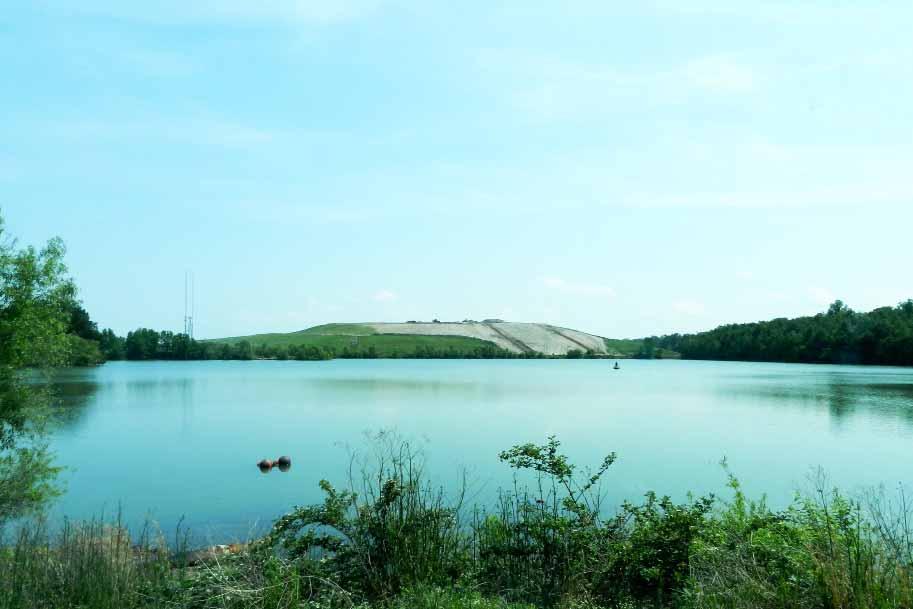
11 Centerville SGA Design Principles Regenerate existing developed areas to capitalize on existing public infrastructure investments. Build a mixed-use center for Centerville. Better connect to existing parks and the Regent Campus through expanded trail networks. Mitigate impacts to the Elizabeth River through stormwater best management practices. Continue to diversify housing choice including workforce housing. Improve the jobs/housing balance to increase capture rate and decrease traffic congestion.
12 Centerville SGA Design Principles Identify immediate and interim actions for landfills to effectively mitigate against adverse impacts Pursue a joint planning strategy with City of. Build a transportation infrastructure network that provides for safety, equity, choice, and economy. Create an education-oriented master-planned community as a unique identity for the Centerville SGA.
13 Updates to the Centerville Masterplan Updated Waste Management Strategy for Virginia Beach Landfill Clarification of Stormwater Management Strategy Refinement of Proposed Street Network Inclusion of proposed I-64 Interchange, and clarification about the impact on properties north of I-64 Revised Office Phasing to maintain the Metroplex One building Revised uses and flexible network for Wood s Corner Shopping Center
14 Total Estimated Development in the Centerville SGA Product Type Total Units/SF Average Capture of Citywide Demand Commercial Office 270,000 13% Medical Office 24,000 2% Retail 350,000 n/a For-Sale Townhouses 250 4% For-Sale Multifamily 95 4% For-Rent Apartments 300 4% (RCLCo)
15 WASTE MANAGEMENT STRATEGY

16
17

18 EXISTING CONDITIONS Two waste management facilities in the Centerville SGA: City Landfill is a public facility HRRC is privately owned Future phases of the City Landfill are south of the current site EXISTING ROAD PROPOSED SGA STREET NETWORK PREFERRED POTENTIAL INTERIOR ROAD ALTERNATIVE POTENTIAL INTERIOR ROAD

19 MITIGATED CONDITIONS Slope stabilization Additional tree buffers Interior roads Shared, consolidated entrance Traffic calming along Centerville Minimize windblown sediment & odor Improve views into the site EXISTING ROAD PROPOSED SGA STREET NETWORK PREFERRED POTENTIAL INTERIOR ROAD ALTERNATIVE POTENTIAL INTERIOR ROAD
20 urban design associates, miles agency, rclco, urs, vhb & wpl centerville sga
21 STORMWATER MANAGEMENT STRATEGIES STRATEGIES APPLIED AT 4 LEVELS: City-wide Policies (wet ponds and low-impact design) Regional and Sub-watershed Facilities Centerville Community Stormwater Facilities On-Site Treatment for Quality and Quantity
22 STORMWATER MANAGEMENT STRATEGIES CITY-WIDE CHALLENGES: Flat land with poor flow High groundwater table Poor soil infiltration Tides and storms Big rainstorms
23 STORMWATER MANAGEMENT STRATEGIES MANAGEMENT TECHNIQUES: Reduction of impervious surfaces Localized storage and infiltration Native plants and marshes help clean the water Treatment trains gradually cleanse the water
24 STORMWATER MANAGEMENT STRATEGIES SGA STRATEGIES: Reduce impervious surfaces Capture rainwater for irrigation and water features Maximize use of bioretention and vegetated water collection Build localized facilities Interconnected linear stormwater conveyance systems
 To Stumpy Lake and Back Bay (Southern")
25 Kempsville Road Road To Eastern Branch of Elizabeth River ( Bay Watershed) To Stumpy Lake and Back Bay (Southern Watershed)

26 Cedar Hill Hill Canal Canal Lake James Drainage Shed HRCC Drainage Shed City Landfill Drainage Shed
27 CITY EFFORTS TO PREVENT NEGATIVE IMPACT ON WATER QUALITY OF LAKE JAMES: Weirs divert drainage from the private landfill and bypass Lake James, except during high-flow events The City s landfill drains completely to the landfill lake & northward to another outlet Water quality tests confirm that drainage from the landfill is not the cause of Lake James water quality problems Excess nutrients from lawn fertilizers are a typical cause of algal blooms Lack of fresh water flushing into and out of the lake can also exacerbate this problem.
28 REFINEMENT OF PROPOSED STREET NETWORK AND TRANSIT INITIATIVES
 CENTERVILLE EXPANSION (PHASES 1-2) INDIAN RIVER/KEMPSVILLE INTERSECTION LYNNHAVEN PARKWAY PHASE")
29 PLANNED AND FUNDED CIP PROJECTS Indian River/Kempsville Intersection Improvements (fully funded, 2014) Centerville Expansion Lynnhaven Parkway Phase XI Improvements (Road widening to 4 lanes, new connector piece, fully funded, 2014) CENTERVILLE EXPANSION (PHASES 1-2) INDIAN RIVER/KEMPSVILLE INTERSECTION LYNNHAVEN PARKWAY PHASE XI

30 PROPOSED STREET NETWORK I-64 INTERCHANGE RIVER BIRCH RUN: EXISTING SECTION IN CHESAPEAKE RIVER BIRCH RUN: PROPOSED PHASE I SECTION RIVER BIRCH RUN: PROPOSED PHASE II SECTION INDIAN RIVER ROAD REGENT UNIVERSITY DRIVE CENTERVILLE TURNPIKE NORTH: EXISTING SECTION CENTERVILLE TURNPIKE NORTH: EXPANSION TO FOUR LANES CENTERVILLE TURNPIKE SOUTH: EXISTING SECTION CENTERVILLE TURNPIKE SOUTH: EXPANSION TO FOUR LANES LOCAL NEIGHBORHOOD 50 ROW LOCAL NEIGHBORHOOD 60 ROW LOCAL NEIGHBORHOOD 70 ROW


31 Indian River Road Providence Road Providence Road Military Highway Highway Indian River Road Indian Lakes Boulevard Parkway Ferrell I-64 Battlefield Blvd Blvd Centerville Turnpike Kempsville Road Road Lynnhaven Parkway Lynnhaven Parkway Greenbrier Road Road urban design associates, miles agency, rclco, urs, vhb & wpl centerville sga
32 Indian River Road Providence Road Providence Road Military Highway Highway Indian n R River Road Indian Lakes Boulevard Parkway Ferrell I-64 Battlefield Blvd Blvd Centerville er lle Turnpike Kempsville Road Road Lynnhaven Parkway Lynnhaven Parkway Greenbrier Road Road urban design associates, miles agency, rclco, urs, vhb & wpl centerville sga

33 Indian River Road Providence Road Providence Road Military Highway Highway Indian n R River Road Indian Lakes Boulevard Parkway Ferrell I-64 Battlefield Blvd Blvd Centerville er lle Turnpike Kempsville Road Road Lynnhaven Parkway Lynnhaven Parkway Greenbrier Road Road

34 Indian River Park Woodstock Providence Road Virginia State State Highway Highway 13 Elementary School Whitehurst Landing Landing Road Road Indian River Road Shoppes College Park Elementary School Founder's Inn CBN Headquarters Level Green Boulevard Regent CBN Corporate Support Kemps River Shopping Center Amerigroup Regent Regent Drive Drive Centerville Turnpike Turnpike Lake James Brandon Middle School I-64 Brandon Boulevard Kempsville Road Road Albright Drive Centerville Turnpike Turnpike Greenbrier Intermediate School HRCC Private Landfill Virginia Beach Landfill Tallwood High School Tallwood Elementary School City View Park Woods Corner Shopping Center Lynnhaven Lynnhaven Parkway Parkway

35 Indian River Park Woodstock Providence Road EXISTING CONDITIONS Virginia State State Highway Highway 13 Elementary School Two lanes with centralized median near Whitehurst Landing Landing Road Road Indian River Road College Park Elementary School Indian River Road Founder's Inn Shoppes River Birch Run & Midtowne Way are Level Green Boulevard CBN Headquarters Regent CBN Corporate Support Kemps River Shopping Center dead-ends Amerigroup Regent Drive Drive Centerville Turnpike Turnpike Lake James Brandon Middle School I-64 Brandon Boulevard Kempsville Road Road Albright Drive Centerville Turnpike Turnpike Greenbrier Intermediate School HRCC Private Landfill Virginia Beach Landfill Tallwood High School Tallwood Elementary School City View Park Woods Corner Shopping Center Lynnhaven Lynnhaven Parkway Parkway

36 Indian River Park Woodstock Providence Road INTERIM IMPROVEMENTS Virginia State State Highway Highway 13 Elementary School Widen Centerville Turnpike to 4 lanes Whitehurst Landing Landing Road Road with a centralized median (from Indian College Park Elementary School Level Green Boulevard Amerigroup Regent Regent Drive Drive Regent Indian River Road CBN Headquarters Founder's Inn Shoppes CBN Corporate Support Centerville Turnpike Turnpike Lake James Kemps River Shopping Center River Road to Kempsville Road, and eventually to the City line) Extend River Birch Run and Regent Drive to connect to a tempo- Brandon Middle School rary road that connects to Centerville I-64 Kempsville Road Road Turnpike. Brandon Boulevard Albright Drive Centerville Turnpike Turnpike Greenbrier Intermediate School HRCC Private Landfill Virginia Beach Landfill Tallwood High School Tallwood Elementary School City View Park Woods Corner Shopping Center Lynnhaven Lynnhaven Parkway Parkway
37 Indian River Park Woodstock Providence Road PROPOSED REALIGNMENT Virginia State State Highway Highway 13 Elementary School If interchange is approved and con- Whitehurst Landing Landing Road Road structed, extend River Birch Run to College Park Elementary School Level Green Boulevard Amerigroup Regent Regent Drive Drive Regent Indian River Road CBN Headquarters Founder's Inn Shoppes CBN Corporate Support Centerville Turnpike Turnpike Lake James Kemps River Shopping Center align with the southern portion of Centerville Turnpike Form a single road that leads to the I-64 ramp I-64 Brandon Middle School Brandon Boulevard Kempsville Road Road Albright Drive Widened to six lanes, if necessary Realign northern section of Centerville Greenbrier Intermediate School HRCC Private Landfill Centerville Turnpike Turnpike to intersect with the newly aligned Virginia Beach Landfill Tallwood High School Centerville Turnpike at a signalized Tallwood Elementary School City View Park Woods Corner Shopping Center Lynnhaven Lynnhaven Parkway Parkway intersection Potential future widening south of Kempsville Road to Lynnhaven Parkway

38 Centerville Turnpike North: Existing Section 145' R.O.W.

39 Centerville Turnpike North: Proposed expansion to four lanes 130'-170 R.O.W.

40
41 PROPOSED I-64 INTERCHANGE Shown as preferred alternative When interchange is developed, River Birch Run Phase II will flow continuously into Centerville Turnpike South to reduce congestion The existing Centerville Turnpike North will T- into the new alignment adjacent to Azalea Garden Church No anticipated impact to houses north of I-64


42 PROPOSED I-64 INTERCHANGE


43
44 Indian River Park Woodstock Providence Road Virginia State State Highway Highway 13 Elementary School Whitehurst Landing Landing Road Road Indian River Road Shoppes College Park Elementary School Level Green Boulevard Regent Drive Drive CBN Headquarters Regent Founder's Inn CBN Corporate Support Kemps River Shopping Center Amerigroup Centerville Turnpike Turnpike Lake James Brandon Middle School I-64 Brandon Boulevard Kempsville Road Road Albright Drive Centerville Turnpike Turnpike Greenbrier Intermediate School HRCC Private Landfill Virginia Beach Landfill Tallwood High School Tallwood Elementary School City View Park Woods Corner Shopping Center Lynnhaven Lynnhaven Parkway Parkway EXISTING HRT ROUTE 12 EXISTING HRT MAX ROUTE 922

45 Indian River Park Woodstock Providence Road Virginia State State Highway Highway 13 Elementary School Whitehurst Landing Landing Road Road Indian River Road Shoppes College Park Elementary School Level Green Boulevard Regent Drive Drive CBN Headquarters Regent Founder's Inn CBN Corporate Support Kemps River Shopping Center Amerigroup Centerville Turnpike Turnpike Lake James Brandon Middle School I-64 Brandon Boulevard Kempsville Road Road Albright Drive EXISTING HRT ROUTE 12 PROPOSED BUS TRANSIT ROUTE Greenbrier Intermediate School HRCC Private Landfill Centerville Turnpike Turnpike PROPOSED BUS TRANSIT ROUTE Virginia Beach Landfill Tallwood High School PROPOSED LRT ALIGNMENT Tallwood Elementary School City View Park Woods Corner Shopping Center Lynnhaven Lynnhaven Parkway Parkway PROPOSED BUS STOP PROPOSED LRT STOP STUDY AREA CITY BOUNDARY EXISTING HRT MAX ROUTE 922

46 Centerville Turnpike North: With LRT 145' R.O.W.
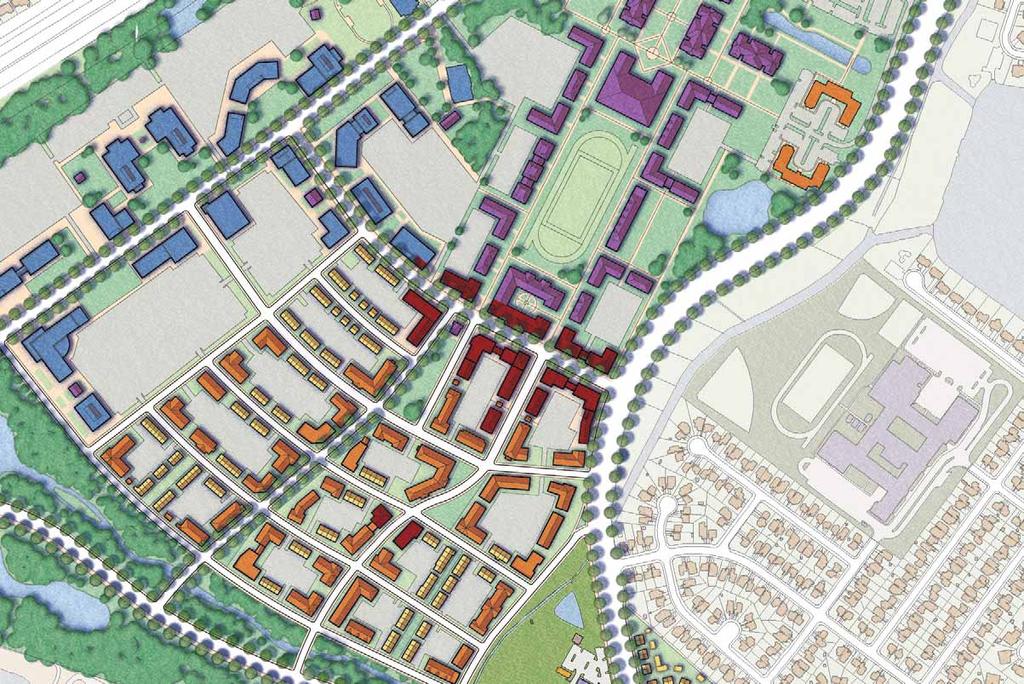
47 LAND USE AND DEVELOPMENT
48 Indian River Park Woodstock Providence Road Virginia State State Highway Highway 13 Elementary School Whitehurst Landing Landing Road Road Indian River Road Shoppes College Park Elementary School Level Green Boulevard Regent Drive Drive CBN Headquarters Regent Founder's Inn CBN Corporate Support Kemps River Shopping Center Amerigroup Centerville Turnpike Turnpike Lake James Brandon Middle School I-64 Brandon Boulevard Kempsville Road Road Albright Drive Centerville Turnpike Turnpike Greenbrier Intermediate School HRCC Private Landfill Virginia Beach Landfill Tallwood High School Tallwood Elementary School City View Park Woods Corner Shopping Center Lynnhaven Lynnhaven Parkway Parkway
49 Indian River Park Woodstock Providence Road Virginia State State Highway Highway 13 Elementary School Whitehurst Landing Landing Road Road Indian River Road Shoppes College Park Elementary School Level Green Boulevard Regent Drive Drive CBN Headquarters Regent Founder's Inn CBN Corporate Support Kemps River Shopping Center Amerigroup Centerville Turnpike Turnpike Lake James Brandon Middle School I-64 Brandon Boulevard Kempsville Road Road Albright Drive Centerville Turnpike Turnpike Greenbrier Intermediate School HRCC Private Landfill Virginia Beach Landfill Tallwood High School Tallwood Elementary School City View Park Woods Corner Shopping Center Lynnhaven Lynnhaven Parkway Parkway 2-STORY MAXIMUM 3-STORY MAXIMUM 5-STORY MAXIMUM
50 Indian River Park Woodstock Providence Road Virginia State State Highway Highway 13 Elementary School Whitehurst Landing Landing Road Road Indian River Road Shoppes College Park Elementary School Level Green Boulevard Regent Drive Drive CBN Headquarters Regent Founder's Inn CBN Corporate Support Kemps River Shopping Center Amerigroup Centerville Turnpike Turnpike Lake James Brandon Middle School I-64 Brandon Boulevard Kempsville Road Road Albright Drive Centerville Turnpike Turnpike UNIVERSITY SHOPPES Greenbrier Intermediate School Virginia Beach Landfill HRCC Private Landfill Tallwood High School REGENT UNIVERSITY EXPANSION Tallwood Elementary School City View Park Woods Corner Shopping Center Lynnhaven Lynnhaven Parkway Parkway REGENT VILLAGE CORPORATE OFFICE BRANDON NEIGHBORHOOD EXPANSION WOODS CORNER
51 Indian River Park Woodstock Providence Road Virginia State State Highway Highway 13 Elementary School Whitehurst Landing Landing Road Road Indian River Road Shoppes College Park Elementary School Level Green Boulevard Regent Drive Drive CBN Headquarters Regent Founder's Inn CBN Corporate Support Kemps River Shopping Center Amerigroup Centerville Turnpike Turnpike Lake James Brandon Middle School I-64 Brandon Boulevard Kempsville Road Road Albright Drive Centerville Turnpike Turnpike Greenbrier Intermediate School HRCC Private Landfill Virginia Beach Landfill Tallwood High School Tallwood Elementary School City View Park Woods Corner Shopping Center Lynnhaven Lynnhaven Parkway Parkway

52

53

54
55

56
57 Indian River Park Woodstock Providence Road Virginia State State Highway Highway 13 Elementary School Whitehurst Landing Landing Road Road Indian River Road Shoppes College Park Elementary School Level Green Boulevard Regent Drive Drive CBN Headquarters Regent Founder's Inn CBN Corporate Support Kemps River Shopping Center Amerigroup Centerville Turnpike Turnpike Lake James Brandon Middle School I-64 Brandon Boulevard Kempsville Road Road Albright Drive Centerville Turnpike Turnpike Greenbrier Intermediate School HRCC Private Landfill Virginia Beach Landfill Tallwood High School Tallwood Elementary School City View Park Woods Corner Shopping Center Lynnhaven Lynnhaven Parkway Parkway
58
 70'")
59 Local Neighborhood Street (70-foot ROW) 70' R.O.W.
60
61 Indian River Park Woodstock Providence Road Virginia State State Highway Highway 13 Elementary School Whitehurst Landing Landing Road Road Indian River Road Shoppes College Park Elementary School Level Green Boulevard Regent Drive Drive CBN Headquarters Regent Founder's Inn CBN Corporate Support Kemps River Shopping Center Amerigroup Centerville Turnpike Turnpike Lake James Brandon Middle School I-64 Brandon Boulevard Kempsville Road Road Albright Drive Centerville Turnpike Turnpike Greenbrier Intermediate School HRCC Private Landfill Virginia Beach Landfill Tallwood High School Tallwood Elementary School City View Park Woods Corner Shopping Center Lynnhaven Lynnhaven Parkway Parkway

62
63

64

65
66
67
68 OPEN SPACE AND TRAIL NETWORKS
69 Indian River Park Woodstock Providence Road Virginia State State Highway Highway 13 Elementary School Whitehurst Landing Landing Road Road Indian River Road Shoppes College Park Elementary School Level Green Boulevard Regent Drive Drive CBN Headquarters Regent Founder's Inn CBN Corporate Support Kemps River Shopping Center Amerigroup Centerville Turnpike Turnpike Lake James Brandon Middle School I-64 Brandon Boulevard Kempsville Road Road Albright Drive Centerville Turnpike Turnpike Greenbrier Intermediate School HRCC Private Landfill Virginia Beach Landfill Tallwood High School Tallwood Elementary School City View Park Woods Corner Shopping Center Lynnhaven Lynnhaven Parkway Parkway
70 Indian River Park Woodstock Providence Road Virginia State State Highway Highway 13 Elementary School Whitehurst Landing Landing Road Road Indian River Road Shoppes College Park Elementary School Level Green Boulevard Regent Drive Drive CBN Headquarters Regent Founder's Inn CBN Corporate Support Kemps River Shopping Center Amerigroup Centerville Turnpike Turnpike Lake James Brandon Middle School I-64 Brandon Boulevard Kempsville Road Road Albright Drive Centerville Turnpike Turnpike Greenbrier Intermediate School HRCC Private Landfill Virginia Beach Landfill Tallwood High School Tallwood Elementary School City View Park Woods Corner Shopping Center Lynnhaven Lynnhaven Parkway Parkway

71
72

73 Indian River Park Woodstock Providence Road Virginia State State Highway Highway 13 Elementary School Whitehurst Landing Landing Road Road Indian River Road Shoppes College Park Elementary School Level Green Boulevard Regent Drive Drive CBN Headquarters Regent Founder's Inn CBN Corporate Support Kemps River Shopping Center Amerigroup Centerville Turnpike Turnpike Lake James Brandon Middle School I-64 Brandon Boulevard Kempsville Road Road Albright Drive Centerville Turnpike Turnpike Greenbrier Intermediate School HRCC Private Landfill Virginia Beach Landfill Tallwood High School SHARED-USE PATH Tallwood Elementary School City View Park Woods Corner Shopping Center Lynnhaven Lynnhaven Parkway Parkway ON-ROAD BIKE LANE SIGNED SHARED ROADWAY ON-ROAD BIKE LANE WITH SHARED USE PATH ON-ROAD BIKE LANE WITH WIDENED SIDEWALKS
74 Indian River Park Woodstock Providence Road Virginia State State Highway Highway 13 Elementary School Whitehurst Landing Landing Road Road Indian River Road Shoppes College Park Elementary School Level Green Boulevard Regent Drive Drive CBN Headquarters Regent Founder's Inn CBN Corporate Support Kemps River Shopping Center Amerigroup Centerville Turnpike Turnpike Lake James Brandon Middle School I-64 Brandon Boulevard Kempsville Road Road Albright Drive Centerville Turnpike Turnpike Greenbrier Intermediate School HRCC Private Landfill Virginia Beach Landfill Tallwood High School Tallwood Elementary School City View Park Woods Corner Shopping Center Lynnhaven Lynnhaven Parkway Parkway

75

76

77
78 WOOD S CORNER (REVISED STRATEGY)
79 Indian River Park Woodstock Providence Road Virginia State State Highway Highway 13 Elementary School Whitehurst Landing Landing Road Road Indian River Road Shoppes College Park Elementary School Level Green Boulevard Regent Drive Drive CBN Headquarters Regent Founder's Inn CBN Corporate Support Kemps River Shopping Center Amerigroup Centerville Turnpike Turnpike Lake James Brandon Middle School I-64 Brandon Boulevard Kempsville Road Road Albright Drive Centerville Turnpike Turnpike Greenbrier Intermediate School HRCC Private Landfill Virginia Beach Landfill Tallwood High School Tallwood Elementary School City View Park Woods Corner Shopping Center Lynnhaven Lynnhaven Parkway Parkway

80 EXISTING CONDITIONS AND INTERIM IMPROVEMENTS Uses: retail and self-storage Improve access with new curb cuts along Kempsville & Centerville Improve pedestrian circulation Improve aesthetics Encourage acade renovations and plantings Increase amenities for people with open space and outdoor cafes.

81 PHASE I FRAMEWORK IMPROVEMENTS Without removing buildings, convert access drives into a network of internal streets Iinvest in street infrastructure, lighting, furniture, pedestrian sidewalks, and a central green Create a block structure that can receive incremental redevelopment as individual owners decide to reinvest

82 PHASE 2 FRAMEWORK IMPROVEMENTS As buildings and properties reach their natural economic lifespans, complete the street framework Connect to neighborhood streets, making it easier for residents to walk Commercial uses such as entertainment, shops, cafes, restaurants, and offices are appropriate
83 Indian River Park Woodstock Providence Road Virginia State State Highway Highway 13 Elementary School Whitehurst Landing Landing Road Road Beth Sholom Home Indian River Road College Park Elementary School Founder's Inn CBN Headquarters Office Development Level Green Boulevard Amerigroup Regent Regent Drive Drive Regent CBN Corporate Support Centerville Turnpike Turnpike New Life Providence Church Regent Expansion Kemps River Shopping Center Lake James I-64 Brandon Middle School Village Kempsville Road Road Brandon Boulevard Albright Drive Virginia Beach Landfill Centerville Turnpike Turnpike Greenbrier Intermediate Academy Area Tallwood Wood s High Corner + School Kempsville Crossing Parks and Lakes City View Park Lynnhaven Lynnhaven Parkway Parkway
84 Development Summary (excluding Wood s Corner) Zone Acreage Housing Retail Office Shoppes Regent Expansion , ,221 Regent Village , ,014 Corporate Office ,369,435 Brandon Neighborhood Expansion ,411 Total ac 1,541 units 293,986 sf 2,369,435 sf
85 Public Hearing Schedule Wed., January 9, 2013 Tue., February 12, 2013 Tue., February 26, 2013 Planning Commission Hearing (Tenative) City Council Hearing for Public Comments (Tenative) City Council Hearing for Vote (Tenative)

86

87

88
89 Indian River Park Woodstock Providence Road Virginia State State Highway Highway 13 Elementary School Whitehurst Landing Landing Road Road Indian River Road Shoppes College Park Elementary School Level Green Boulevard Regent Drive Drive CBN Headquarters Regent Founder's Inn CBN Corporate Support Kemps River Shopping Center Amerigroup Centerville Turnpike Turnpike Lake James Brandon Middle School I-64 Brandon Boulevard Kempsville Road Road Albright Drive Centerville Turnpike Turnpike Greenbrier Intermediate School HRCC Private Landfill Virginia Beach Landfill Tallwood High School Tallwood Elementary School City View Park Woods Corner Shopping Center Lynnhaven Lynnhaven Parkway Parkway
90
I-264 CORRIDOR EVALUATION STUDY. September 7, 2016 Eric Stringfield VDOT Planning Director Chris Lawrence AECOM Senior Transportation Engineer
 I-264 CORRIDOR EVALUATION STUDY September 7, 2016 Eric Stringfield VDOT Planning Director Chris Lawrence AECOM Senior Transportation Engineer Study Overview Interchange Locations Study Context Follow-up
Ocean Park Boulevard Green Street Project Alternatives & Trade Offs
 Planning Commission March 4, 2009 Ocean Park Boulevard Green Street Project Alternatives & Trade Offs Purpose of Tonight s Meeting Review concept plans and options Provide input on alternatives and trade-offs
Chapter 5 Future Transportation
 Chapter 5 Future Transportation The Future Land Use Plan identifies the desired land use designations. The land uses desired for Crozet depend, in large part, on the success of the transportation system,
Tonight is for you. Learn everything you can. Share all your ideas.
 Strathcona Neighbourhood Renewal Draft Concept Design Tonight is for you. Learn everything you can. Share all your ideas. What is Neighbourhood Renewal? Creating a design with you for your neighbourhood.
In station areas, new pedestrian links can increase network connectivity and provide direct access to stations.
 The Last Mile Planning for Pedestrians Planning around stations will put pedestrians first. Making walking to stations safe and easy is important; walking will be a part of every rapid transit Accessible
Proposed. City of Grand Junction Complete Streets Policy. Exhibit 10
 Proposed City of Grand Junction Complete Streets Policy Exhibit 10 1 City of Grand Junction Complete Streets Policy Vision: The Complete Streets Vision is to develop a safe, efficient, and reliable travel
Living Streets Policy
 Living Streets Policy Introduction Living streets balance the needs of motorists, bicyclists, pedestrians and transit riders in ways that promote safety and convenience, enhance community identity, create
City of Sammamish. Welcome. Issaquah-Fall City Road Improvements Project Phase I Design: 242nd Avenue SE to Klahanie Drive SE
 Welcome Welcome to the third community meeting for the Issaquah-Fall City Road Improvements Project. AGENDA 6:00 p.m. Welcome and sign-in 6:10 p.m. Presentation 6:50 p.m. Open house Learn about the roadway
FOCUS AREA 1 - Alberta Avenue Pocket Park 3 (121 Ave and 92 St)
") FOCUS AREA 1 - Alberta Avenue Pocket Park 3 (121 Ave and 92 St) New benches Plant evergreen trees Widen existing sidewalk from 1.5m to 1.8m Marked crosswalk 1.8m wide sidewalk Add pedestrian oriented lights
FOCUS AREA 1 - Alberta Avenue Pocket Park 3 (121 Ave and 92 St) New benches Plant evergreen trees Widen existing sidewalk from 1.5m to 1.8m Marked crosswalk 1.8m wide sidewalk Add pedestrian oriented lights
Reams Road RCA Study. Board of County Commissioners Public Hearing
 Reams Road RCA Study Board of County Commissioners Public Hearing April 24, 2018 Presentation Overview Study Overview Existing Conditions Development of Alternatives Preferred Alternative Public Involvement
Ann Arbor Downtown Street Plan
 1 Ann Arbor Downtown Street Plan Public Workshop #1 We know that. 2 Public right-of-way (streets, sidewalks, and alleys) make up 30% of the total District area of downtown. Streets need to provide mobility
CONNECTIVITY PLAN. Adopted December 5, 2017 City of Virginia Beach
 CONNECTIVITY PLAN Adopted December 5, 2017 City of Virginia Beach CONTENTS 1.0 Background & Purpose... 2 2.0 Existing Inventory & Analysis... 3 ViBe District Existing Walking Conditions... 4 3.0 ViBe District
Project Description Form 6V
 Project Description Form 6V Basic Project Information Submitting Jurisdiction/Agency: Prince William County Project Title: Route 15 Widening: Route 55 to south of RR tracks & Construct RR Overpass Project
Bicycle and Pedestrian Plans and Improvements
 Bicycle and Pedestrian Plans and Improvements Presented to the City Council By Randle Harwood, Planning and Development, and Richard Zavala, Parks and Community Services September 24, 2013 Purpose Review
RESOLUTION NO ?? A RESOLUTION OF THE CITY OF NEPTUNE BEACH ADOPTING A COMPLETE STREETS POLICY
 RESOLUTION NO. 2018-?? A RESOLUTION OF THE CITY OF NEPTUNE BEACH ADOPTING A COMPLETE STREETS POLICY WHEREAS, safe, convenient, and accessible transportation for all users is a priority of the City of Neptune
Solana Beach Comprehensive Active Transportation Strategy (CATS)
") Solana Beach Comprehensive Active Transportation Strategy (CATS) 3.0 Goals & Policies The Solana Beach CATS goals and objectives outlined below were largely drawn from the Solana Beach Circulation Element
Solana Beach Comprehensive Active Transportation Strategy (CATS) 3.0 Goals & Policies The Solana Beach CATS goals and objectives outlined below were largely drawn from the Solana Beach Circulation Element
Montgomery County Life Sciences Center Loop Trail
 Montgomery County Life Sciences Center Loop Trail Advisory Committee Meeting #1 February 10, 2015 Agenda 1. Project Background 2. Existing Conditions Analysis 3. Examples from Elsewhere 4. Discussion Project
Agenda. Overview PRINCE GEORGE S PLAZA METRO AREA PEDESTRIAN PLAN
 PRINCE GEORGE S PLAZA METRO AREA PEDESTRIAN PLAN May 28, 2008 Agenda Welcome and introductions Project overview and issue identification Planning context and strengths Design challenges and initial recommendations
4. ENVIRONMENTAL IMPACT ANALYSIS 9. TRANSPORTATION AND TRAFFIC
 4. ENVIRONMENTAL IMPACT ANALYSIS 9. TRANSPORTATION AND TRAFFIC 4.9.1 INTRODUCTION The following section addresses the Proposed Project s impact on transportation and traffic based on the Traffic Study
DRAFT BUENA VISTA 2020 TRANSPORTATION PLAN
 DRAFT BUENA VISTA 2020 TRANSPORTATION PLAN DEVELOPED BY THE TRANSPORTATION PLANNING DIVISION OF THE VIRGINIA DEPARTMENT OF TRANSPORTATION IN COOPERATION WITH THE U.S. DEPARTMENT OF TRANSPORTATION, FEDERAL
Exhibit 1 PLANNING COMMISSION AGENDA ITEM
 Exhibit 1 PLANNING COMMISSION AGENDA ITEM Project Name: Grand Junction Circulation Plan Grand Junction Complete Streets Policy Applicant: City of Grand Junction Representative: David Thornton Address:
5 CIRCULATION AND STREET DESIGN
 5 CIRCULATION AND STREET DESIGN This chapter describes circulation and streetscape improvements proposed for the Northwest Chico Specific Plan Area. It includes detailed design specifications for existing
PRINCE GEORGE S PLAZA METRO AREA PEDESTRIAN PLAN
 PRINCE GEORGE S PLAZA METRO AREA PEDESTRIAN PLAN May 28, 2008 Agenda Welcome and introductions Project overview and issue identification Planning context and strengths Design challenges and initial recommendations
Executive Summary Route 30 Corridor Master Plan
 Route Corridor Master Plan Project Overview The Route Corridor Master Plan is a coordinated multimodal transportation and land use plan for the entire stretch of Route through East Whiteland Township,
Transportation Corridor Studies: Summary of Recommendations
 Transportation Corridor Studies: Summary of Recommendations Route 4 Corridor Study: Route 10 Corridor Study: Route 44 Corridor Study: Route 175 Corridor Study: Route 5/15 Corridor Study: Rentschler Field
MOUNTAIN HOUSE SPECIFIC PLAN I 9.1 INTRODUCTION ASSUMPTIONS TRANSPORTATION FACILITIES TRANSPORTATION IMPROVEMENTS PHASING 9.
 CHAPTER NINE: TRANSPORTATION AND CIRCULATION 9.1 INTRODUCTION 9.1 9.2 ASSUMPTIONS 9.1 9.3 TRANSPORTATION FACILITIES 9.1 9.4 TRANSPORTATION IMPROVEMENTS PHASING 9.3 LIST OF FIGURES LIST OF TABLES Figure
TRANSPORTATION NEEDS ASSESSMENT
 TRANSPORTATION NEEDS ASSESSMENT A travel demand analysis was carried out to determine the operational issues and the potential benefit that adding traffic capacity would have on the road network. All the
Section 7 Complete Green Street Guidelines DRAFT
 Section 7 Complete Green Street Guidelines DRAFT 1 Section: 7.0 COMPLETE GREEN STREET GUIDELINES These guidelines serve as options to mitigate the environmental impact of a project as well as guide the
3.0 Future Conditions
 3.0 Future Conditions In order to be able to recommend appropriate improvements to the transportation system of the Town, it is important to first understand the nature and volume of traffic that is expected
integrated action plan
 public presentation. june 24, 2009. city of portsmouth, nh islington corridor integrated action plan richardson & associates, landscape architects evan haynes, public arts consultant Islington Street Corridor
Community Open House December 13, A project of the Green Infrastructure Center, supported by Skeo Solutions
 Community Open House December 13, 2011 A project of the Green Infrastructure Center, supported by Skeo Solutions Project Background The Green Infrastructure Center, Inc. (GIC) was formed in 2006 to help
APPENDIX G: INTERSECTION NEEDS AT OKEECHOBEE BOULEVARD
 APPENDIX G: INTERSECTION NEEDS AT OKEECHOBEE BOULEVARD INTERSECTION NEEDS AT SR 7 and OKEECHOBEE BOULEVARD SR 7 Extension Project Development and Environment (PD&E) Study From Okeechobee Boulevard (SR
Corpus Christi Metropolitan Transportation Plan Fiscal Year Introduction:
 Introduction: The Safe, Accountable, Flexible, Efficient Transportation Equity Act: A Legacy for Users (SAFETEA-LU) has continued the efforts started through the Intermodal Surface Transportation Efficiency
Southbend to Prima Vista. October 30, Floresta Corridor Master Plan
 Application of a Complete Street initiative and how it might function operationally 8 8 Southbend to Prima Vista October 30, 2017 Presentation Agenda 2 Perspective and History Traffic projections, Levels
NOTICE OF AVAILABILITY/NOTICE OF COMMENT PERIOD OF A DRAFT EIR/EIS/EIS FOR PUBLIC REVIEW AND HEARINGS
 Tahoe Transportation District 128 Market Street, Suite 3F Stateline, NV 89449 Phone: (775) 589-5500 www.tahoetransportation.org Federal Highway Administration 650 Capitol Mall, Suite 4-100 Sacramento,
NEWMARKET UPHAM S CORNER
 SOUTH STATION Planning Initiative NEWMARKET UPHAM S CORNER COLUMBIA ROAD (P) FOUR CORNERS/GENEVA Working Advisory Group (WAG) Meeting #5 TALBOT AVENUE MORTON STREET BLUE HILL AVE/CUMMINS HWY (P) RIVER
WELCOME. Purpose of the Open House. Update you on the project. Present a draft recommended plan. Receive your input
 WELCOME Purpose of the Open House The Town of Smiths Falls has initiated the Beckwith Street Redevelopment Plan that includes the preparation of a streetscape functional design for the renewal of Beckwith
Bridges and Arizona Crossings
 Circulation and Transportation 5-11 Discovery Street/Barham Drive. Discovery Street is planned 5.4.3 Specific Plan Circulation Improvements to be extended eastward from its terminus at Craven Road Circulation
Ocean Park Boulevard Streetscape Improvement Project Alternatives & Trade Offs
 City Council Study Session January 27, 2009 Ocean Park Boulevard Streetscape Improvement Project Alternatives & Trade Offs Scope of Work Purpose of Tonight s Meeting Review work to date and direct staff
INNER LOOP EAST. AIA Rochester Annual Meeting November 13, 2013 TRANSFORMATION PROJECT. Bret Garwood, NBD Erik Frisch, DES
 INNER LOOP EAST TRANSFORMATION PROJECT AIA Rochester Annual Meeting November 13, 2013 Bret Garwood, NBD Erik Frisch, DES Why? We are building a city that encourages walking, biking and enjoying the outdoor
Corridor Recommendations and Implementation
 Corridor Recommendations and Implementation INTER-PARCEL CONNECTIVITY Both alternative Concept A and Concept B segments of the Community Core suggest a system of interconnected local streets and local
REGIONAL BICYCLE AND PEDESTRIAN DESIGN GUIDELINES
 REGIONAL BICYCLE AND PEDESTRIAN DESIGN GUIDELINES November 16, 2011 Deb Humphreys North Central Texas Council of Governments Bicycle and Pedestrian Advisory Committee Snapshot of the Guide 1. Introduction
Make Lincoln Highway an economically vibrant corridor that is safe, efficient, and beautiful for local residents and visitors.
 Lincoln Highway Streetscape Plan Stakeholder Workshop #2 Handout Contents Introduction and Project Vision Planning Principles Specific Recommendations including a Proposed Typical Roadway Section Renderings
M-58 HIGHWAY ACCESS MANAGEMENT STUDY Mullen Road to Bel-Ray Boulevard. Prepared for CITY OF BELTON. May 2016
 M-58 HIGHWAY ACCESS MANAGEMENT STUDY Prepared for CITY OF BELTON By May 2016 Introduction Missouri State Highway 58 (M-58 Highway) is a major commercial corridor in the City of Belton. As development has
Project Update May 2018
 Project Update May 2018 Dakota County, in cooperation with the City of Lakeville, is planning to reconstruct 202 nd Street West (County Road 50) from Holyoke Avenue to Cedar Avenue (County Road 23). 202
GRTC Bus Rapid Transit: Semi-Final Design Phase Public Meetings: October 26 & 27, 2015
 GRTC Bus Rapid Transit: Semi-Final Design Phase Public Meetings: October 26 & 27, 2015 Welcome! Meeting Agenda Project update presentation Up to 15 minutes for Pulse Q&A about project design. (Please reserve
Omaha s Complete Streets Policy
 Omaha s Complete Streets Policy (Adopted August 2015) VISION To create great places and enhance our quality of life, the City of Omaha will provide safe, accessible streets for all users. Complete Streets
Ocean Park Boulevard Green Street Project Community Workshop
 Ocean Park Boulevard Green Street Project Community Workshop 2.2.10 Project Objectives Community Priority: reclaim OPB for public open space. Build upon LUCE principles; neighborhood enhancement, connectivity,
2045 Long Range Transportation Plan. Summary of Draft
 2045 Long Range Transportation Plan Summary of Draft Fredericksburg Area Metropolitan Planning Organization The George Washington Region includes the City of Fredericksburg and the counties of Caroline,
Table #6 VISION CHARACTERISTICS
 Table #6 VISION White Flint is a place to live, work, play, shop, and walk with sufficient density to encourage quality redevelopment. Vibrant streets and consistent streetscapes are important. CHARACTERISTICS
Project Description Form 8EE
 Project Description Form 8EE Basic Project Information Submitting Jurisdiction/Agency: Town of Dumfries Project Title: Route 1 (Fraley Blvd) Widening: Brady's Hill Road to Dumfries Road Project Location:
Highway 56 Traffic Study Rymal Road to Cemetery Road
 January 31, 2018 6:00 pm 8:00 pm Highway 56 Traffic Study Rymal Road to Cemetery Road City of Hamilton Public Meeting 2 2 Purpose of Public Meeting To review and obtain public input and comments on the
VDOT I-66 Inside the Beltway Eastbound Widening Environmental Assessment. Staff Recommendations
 VDOT I-66 Inside the Beltway Eastbound Widening Environmental Assessment Staff Recommendations Department of Environmental Services Transportation January 28, 2017 Timeline of Transform66 June 2012: I-66
Transportation Planning Division
 Transportation Planning Division Presentation Outline Study Tasks Recap of Previous Meetings Data Collected Focus Areas within Study Limits Design Principles Tool Box Recommended Concepts Schedule Moving
San Jose Transportation Policy
 San Jose Transportation Policy Protected Intersections in LOS Policies to Support Smart Growth Presented by: Manuel Pineda City of San Jose Department of Transportation Bay Area Map San Francisco Oakland
6.4 RECOMMENDED IMPROVEMENTS
 6.4 RECOMMENDED IMPROVEMENTS 6.4.1 Williston Road Recommendations While all alternatives would be an improvement over existing conditions, Alternative 3B is recommended over the others because it provides
Lincoln Neighborhood Corridor Plan The LiNC
 CITY OF SANTA MONICA Lincoln Neighborhood Corridor Plan The LiNC PLANNING COMMISSION September 2, 2015 COMMUNITY DESIGN + ARCHITECTURE TEAM: Community Design + Architecture Iteris Studio 111 Urban Place
STONY PLAIN ROAD STREETSCAPE
 Jasper Place Revitalization Strategy: Vision The people involved in the Jasper Place Revitalization Strategy envision: Goal 1: Feeling safe in our community Create a community where feeling safe is common--where
2011 Capital Projects University Area - Community Council Priority List Municipality of Anchorage
 2011 Capital Projects University Area - Community Council Priority List Municipality of Anchorage 2 Project Management and Engineering Projects on 40th Ave Extension - Lake Otis Pkwy to Dale St $18,103,000
RIVERSIDE, Newton MA BH NORMANDY RIVERSIDE LLC. Riverside Station. A green, transit-oriented community
 Riverside Station A green, transit-oriented community October 6, 2011 TONIGHT S AGENDA: 1. Project Update (5 min.) 2. Master Plan Update (10 min.) 3.Traffic Plan Update (10 min.) Questions & Answers MASTER
City of Wayzata Comprehensive Plan 2030 Transportation Chapter: Appendix A
 A1. Functional Classification Table A-1 illustrates the Metropolitan Council s detailed criteria established for the functional classification of roadways within the Twin Cities Metropolitan Area. Table
Mission-Geneva Transportation Study Community Workshop 2 July 8, 2006
 Community Workshop 2 July 8, 2006 Small Group Workbook 1 Basic Improvements on Mission Street Streetscape. Pedestrian-scale lighting; landscaping; community art on utility boxes; more (possibly unique)
A Matter of Fairness: ROCOG s Environmental Justice Protocol. What is Mobility Limitation?
 No Person Left Behind What is Mobility Limitation? What is the Access Limitation? Environmental Justice population should be provided adequate mobility & access to meet their needs; Identify acceptable
DALLAS MIDTOWN REDEVELOPMENT PLAN FOCUS NORTH TEXAS Peer Chacko, AICP, Assistant Director, City of Dallas
 DALLAS MIDTOWN REDEVELOPMENT PLAN FOCUS NORTH TEXAS 2014 Peer Chacko, AICP, Assistant Director, City of Dallas Dallas Midtown: Strategic growth area Future transit node 2 Peterson Road Study Area Galleria
Hampton Roads Pedestrian and Bicycle Advisory Committee
 Hampton Roads Pedestrian and Bicycle Advisory Committee HRTPO Transportation Technical Advisory Committee November 6, 2013 Carl E. Jackson III, AICP Transportation Planning Specialist Hampton Roads District
TRAFFIC ACTION PLAN. North Central Neighborhood CITY OF SAN MATEO
 TRAFFIC ACTION PLAN North Central Neighborhood CITY OF SAN MATEO Draft February 2017 Table of Contents Introduction... 1 The Traffic Forum Process... 4 Neighborhood Traffic Issues... 6 Neighborhood Recommendations
CONNECTING PEOPLE TO PLACES
 CONNECTING PEOPLE TO PLACES 82 EAST BENCH MASTER PLAN 07 Introduction The East Bench transportation system is a collection of slow moving, treelined residential streets and major arteries that are the
Route 79/Davol Street Corridor Study
 Route 79/Davol Street Corridor Study Fall River, MA Public Information Meeting #2 November 21, 2013 Fall River Heritage State Park Fall River, MA Agenda Welcome and Introductions Overview of Study Process
WHEREAS delivery trucks also pass through the Narrows, into the northern parking lot, to loading docks in the back of the building.
 CEDAR-ISLES-DEAN NEIGHBORHOOD ASSOCIATION ( CIDNA ) RESOLUTION OPPOSING A DRUG STORE DRIVE THRU, AND COMMENDING DORAN COMPANIES FOR PROPOSING MITIGATING AMENITIES INCLUDING NEW LANDSCAPING AND A DEDICATED
See Figure 38, Existing Nonmotorized Connections.
 Nonmotorized Connections Existing Nonmotorized Connections Pedestrian, vehicle and bike traffic access and movements are confined primarily to Penny Drive on campus. Due to the steep slope along the length
ALBERTA AVENUE WHAT WE HEARD REPORT BUILDING GREAT NEIGHBOURHOODS
 ALBERTA AVENUE WHAT WE HEARD REPORT BUILDING GREAT NEIGHBOURHOODS FEBRUARY 2019 EXECUTIVE SUMMARY Starting in 2019, Alberta Avenue will see the replacement and enhancement of its aging collector and local
FONTAINE AVENUE STUDY Final Report
 FONTAINE AVENUE STUDY Final Report March 28, 2005 FONTAINE AVENUE STUDY City of Charlottesville March 28, 2005 Renaissance Planning Group Kenneth Schwartz, FAIA, AICP Director of Design Leigh Wilkerson,
S T A T I O N A R E A P L A N
 The Circulation and Access Plan describes vehicle, pedestrian, and transit improvements recommended within the Concept Plan. In order to create and sustain a vibrant business district that provides pedestrian-friendly
ROUTE 81 CORRIDOR STUDY DESIGN CONCEPTS
 RT 81 Corridor Study CLINTON ROUTE 81 CORRIDOR STUDY DESIGN CONCEPTS View north on High Street, with potential improvements to the streetscape Draft Recommendations November 8 th, 2018 TOWN OF CLINTON
Bluffdale/ UDOT South High-T Intersection Project Type Operations
 Bluffdale/ UDOT 14600 South High-T Intersection Project Type Operations 14600 South and Redwood Road $ 600,000 $ 550,000 This project is to install a new High-T intersection at Redwood Road and 14600 South
Anniedale- Tynehead NCP Best Practices in Transportation Planning Summary
 Anniedale- Tynehead NCP Best Practices in Transportation Planning Summary The City of Surrey Anniedale-Tynehead NCP Best Practices Transportation Summary This document provides a summary of the Bunt &
Institute for Real Estate Management Chapter (IREM) 77 VDOT Northern Virginia Megaprojects September 13, 2017
 77 VDOT Northern Virginia Megaprojects September 13, 2017") Institute for Real Estate Management Chapter (IREM) 77 VDOT Northern Virginia Megaprojects September 13, 2017 Susan Shaw, P.E., Megaprojects Director Virginia Department of Transportation Northern Virginia
Institute for Real Estate Management Chapter (IREM) 77 VDOT Northern Virginia Megaprojects September 13, 2017 Susan Shaw, P.E., Megaprojects Director Virginia Department of Transportation Northern Virginia
General Plan Circulation Element Update Scoping Meeting April 16, 2014 Santa Ana Senior Center, 424 W. 3rd Street, Santa Ana, CA 92701
 General Plan Circulation Element Update Scoping Meeting April 16, 2014 Santa Ana Senior Center, 424 W. 3rd Street, Santa Ana, CA 92701 Meeting Agenda 1. Purpose of Scoping Meeting 2. Project Overview 3.
City of Davis East Covell Corridor Plan
 Community Open House #2 January 22, 2014 6:00 8:00 p.m. Veterans Memorial Center, Club Room City of Davis Introduction The (ECCP) is a taking a comprehensive look at the existing transportation systems
Road Alterations - Wellington Street East, Church Street, and Front Street Intersection
 REPORT FOR ACTION Road Alterations - Wellington Street, Church Street, and Front Street Intersection Date: November 1, 2016 To: Toronto and York Community Council From: Director, Public Realm Section,
Figure 4-10: Pedestrian Improvements Types of Potential Station Area Improvements - Place-Making Improvements
 INCORPORATE FEATURE PAVIN IN CROSSWALK AND INTERSECTION FIELDS Identifies high-priority pedestrian areas and create a station identity through colorful and interesting patterns ADD CURB EXTENSIONS Extending
SR-203 Sidewalks and Town-Wide Mobility Improvements. Town Council Presentation September 7, 2016
 SR-203 Sidewalks and Town-Wide Mobility Improvements Town Council Presentation September 7, 2016 SR-203 Sidewalks and Town- Wide Mobility Improvements SR-203 Sidewalks and Appurtenances Town-Wide Mobility
MIXED USE AND STREETSCAPE INTEGRATION Avondale Will Basil Juliana Zannotto
 MIXED USE AND STREETSCAPE INTEGRATION Avondale Will Basil Juliana Zannotto Creating new development so that people will stop and see what Avondale has to offer The goal for my project was simple. I wanted
Giles Run Connector Road
 Giles Run Connector Road Laurel Hill Adaptive Reuse Area to Laurel Crest Drive South County Federation Meeting June 14, 2016 History Connector road included in the Laurel Hill Comprehensive Plan amendment
FY STATEWIDE TRANSPORTATION IMPROVEMENT PROGRAM New Jersey Department of Transportation Projects
 Cape May-Lewes Ferry 00377A 00377A This project will provide for the rehabilitation of the approach roads and signage for the Cape May- Lewes ferry. Other roadside features will be upgraded to meet present
Why invest in the 1 Street S.W. Corridor?
 Why invest in the 1 Street S.W. Corridor? This project is an investment in the Beltline Community and Calgary s economy. It is anticipated that The City s investment along this corridor will help with
TRANSPORTATION COMMISSION Agenda Staff Report
 TRANSPORTATION COMMISSION Agenda Staff Report Agenda Item No. 5.a DATE: JULY 31, 2014 TO: FROM: SUBJECT: TRANSPORTATION COMMISSION COMMUNITY DEVELOPMENT DEPARTMENT - PLANNING DRAFT OLYMPIC CORRIDOR PREFERRED
4 DISRUPTION MANAGEMENT PLAN HIGHWAY 7 RAPIDWAY CONSTRUCTION BETWEEN BAYVIEW AVENUE AND WARDEN AVENUE TOWNS OF MARKHAM AND RICHMOND HILL
 4 DISRUPTION MANAGEMENT PLAN HIGHWAY 7 RAPIDWAY CONSTRUCTION BETWEEN BAYVIEW AVENUE AND WARDEN AVENUE TOWNS OF MARKHAM AND RICHMOND HILL The Transportation Services Committee recommends the adoption of
Application of a Complete Street
 Application of a Complete Street Southbend to Prima Vista Update May 14, 2018 Meeting Agenda Perspective and History Public input received Typical sections being considered Presentation of the 2-lane master
TRAFFIC ACTION PLAN. Laurie Meadows Neighborhood CITY OF SAN MATEO
 TRAFFIC ACTION PLAN Laurie Meadows Neighborhood CITY OF SAN MATEO Draft January 2017 Table of Contents Introduction... 2 The Traffic Forum Process... 5 Neighborhood Traffic Issues... 7 Neighborhood Recommendations
Appendix B - Street Sections
 Appendix B - Street Sections 6TH STREET CORRIDOR PLAN STREET SECTIONS The street sections in Appendix B include recommended improvements to streets for North Glenwood. They include existing conditions
State Road 54/56 Tampa Bay s Northern Loop. The Managed Lane Solution Linking I-75 to the Suncoast Parkway
 State Road 54/56 Tampa Bay s Northern Loop The Managed Lane Solution Linking I-75 to the Suncoast Parkway SUNCOAST PARKWAY Both I 75 and the Suncoast Parkway are planning, or in the process of constructing,
Chapter 4: Funding and Implementation
 Chapter 4: Funding and Implementation 83 84 Cost Estimating Cost estimating is an iterative process. When a project is in the conceptual stage, preliminary cost estimates are also provided conceptually,
West Dimond Blvd Upgrade Jodhpur Street to Sand Lake Road
 West Dimond Blvd Jodhpur St to Sand Lake CSS Transportation Project Summary Municipality of Anchorage Project # 05 005 Project Manager: John Smith, P.E. (MOA PM&E) Project Administrator: Julie Makela,
Los Altos Hills Town Council - June 18, 2015 Palo Alto City Council June 22, AGENDA ITEM #2.B Presentation
 Los Altos Hills Town Council - June 18, 2015 Palo Alto City Council June 22, 2015 AGENDA ITEM #2.B Presentation Previous Presentations Los Altos Hills Town Council in May 2014 and February 2015 Palo Alto
Lincoln Highway Streetscape Plan Concept Plan
 Lincoln Highway Streetscape Plan Concept Plan November 14, 2014 Introduction This report provides a summary of conceptual transportation, land use, and design recommendations in the Lincoln Highway Streetscape
12/4/2016 VIA . RE: Grocery Outlet Del Paso (DR16-328)
") 12/4/2016 VIA EMAIL Ethan Meltzer, Assistant Planner City of Sacramento Community Development Department 300 Richards Blvd, 3 rd Floor Sacramento, CA 95811 RE: Grocery Outlet Del Paso (DR16-328) Dear Mr.
12/4/2016 VIA EMAIL Ethan Meltzer, Assistant Planner City of Sacramento Community Development Department 300 Richards Blvd, 3 rd Floor Sacramento, CA 95811 RE: Grocery Outlet Del Paso (DR16-328) Dear Mr.
East Downtown Tax Increment Reinvestment Zone (TIRZ) No. 15 Infrastructure Assessment Study
 No. 15 Infrastructure Assessment Study") East Downtown Tax Increment Reinvestment Zone (TIRZ) No. 15 Infrastructure Assessment Study Houston, TX Technical Memorandum April 15 th, 2009 Prepare by: 2950 North Loop West, Ste. 900 Houston, TX 77092
East Downtown Tax Increment Reinvestment Zone (TIRZ) No. 15 Infrastructure Assessment Study Houston, TX Technical Memorandum April 15 th, 2009 Prepare by: 2950 North Loop West, Ste. 900 Houston, TX 77092
Land Use Bicycle Spaces Required Type Residential
 SAMPLE ORDINANCES AND RESOLUTIONS APPENDIX B SAMPLE BICYCLE PARKING ORDINANCE Land Use Bicycle Spaces Required Type Residential Single Family/Two Family N/A N/A Apartment/Townhome 1 per unit plus 6 space
5/7/2013 VIA . RE: University Village Safeway Expansion (P13-019)
") 5/7/2013 VIA EMAIL David Hung, Associate Planner Community Development Department, Current Planning Division City of Sacramento 300 Richards Boulevard, 3 rd Floor Sacramento, CA 95811 RE: University Village
5/7/2013 VIA EMAIL David Hung, Associate Planner Community Development Department, Current Planning Division City of Sacramento 300 Richards Boulevard, 3 rd Floor Sacramento, CA 95811 RE: University Village