cby1,ly STAFF REPORT Meeting Date: February 6, 2018 To:
|
|
|
- Leslie McCarthy
- 5 years ago
- Views:
Transcription
1 cby1,ly STAFF REPORT Meeting Date: February 6, 2018 To: Honorable Mayor & City Council From: Aaron Kunz, Deputy Director of Transportation Subject: North Santa Monica Boulevard Bicycle Lanes Attachments: 1. lteris Technical Memorandum INTRODUCTION At its June 20, 2017 meeting, the City Council agreed to proceed with striping North Santa Monica Boulevard (NSMB) between Doheny Drive and Wilshire Boulevard with five-foot wide, high visibility, bicycle lanes in both directions at the completion of the NSMB Reconstruction project. This report provides an analysis of high visibility bicycle lanes and a recommended striping plan. DISCUSSION The attached Technical Memorandum prepared by Iteris provides a background and analysis of high visibility bicycle lanes. Based on this analysis, staff recommends the following: 1) Installing green high visibility treatments. The California Traffic Control Devices Committee has received interim approval from the Federal Highway Administration (FHWA) for green colored lanes. The City would be required to apply to the Committee to use any other color and based on research by Iteris, it is unlikely to be approved by the FHWA. 2) Thermoplastic material applied with retro reflective and anti-skid material. This material has the highest durability of all options available. All lane and crosswalk striping on NSMB will be thermoplastic. 3) Installing green thermoplastic in areas where potential conflicts may occur, including 100 approaches to the intersection and a short 20 segment of solid green on the far side of the intersection. Communities that have colored the entire length of bicycle lanes have experienced costly maintenance expenses. 4) Green dashes across the intersection.
2 Meeting Date: February 6, ) Specific design treatments at Wilshire Blvd, Beverly/Palm and Doheny Melrose as outlined in the report. FISCAL IMPACT The estimated cost of installing bicycle treatments as recommended is approximately $35,000 will be funded by the Santa Monica Boulevard Capital Improvement Program budget number Thermoplastic needs to be re-installed every 3-5 years for maintenance and will be funded by the Street Sign and Striping Capital Improvement Program budget number RECOMMENDATION To proceed with installation of green, high visibility bicycle lanes as outlined in this report. Susan Healy Keene, AICP Page2of2 2/1/2018
3 Attachment 1
4 DRAFT MEMORANDUM To: Aaron Kunz, Deputy Director City of Beverly Hills Transportation 455 North Rexford Drive Beverly Hills, CA From: Michael Meyer, Naree Kim, Iteris, Inc. Vincent Hellens, Psomas. Date: January 22, 2018 RE: DRAFT Technical Issues Related to Bicycle Lanes on North Santa Monica Boulevard Background North Santa Monica Boulevard is currently under construction between Doheny Drive and Wilshire Boulevard. The existing roadway will be completely reconstructed with new base material and pavement. The corridor will also have drainage improvements, new street lighting and landscape improvements. Prior to its reconstruction, the roadway width was 63 from curb to curb along two thirds of the project limits and 60 between Wilshire Boulevard and Canon Drive, along the Santa Monica Five parking structures. On July 21, 2015, the City Council approved construction documents for North Santa Monica Boulevard (NSMB) the roadway which maintained the 63 width in the 63 wide segments and included a 2 4 widening along the south side of the roadway in the 60 segment to potentially allow room for bicycle lanes on the reconstructed street. The 2 4 widening was the maximum allowable width that could be accommodated without disturbing the Santa Monica Five parking structures foundation design. The final construction documents for the reconstruction included striping plans for a 10 center left turn lane, an 11 number one lane and a 15.5 outside (curb) lane in each direction, for a total cross section of 63. In the area along the parking structures where the street will be 62 4 wide, the four travel lanes are planned to be 2 narrower. The current design plans were prepared with the assumption that the wider outside lane could accommodate bicyclists in the wider lane, or if the Council directed, a solid white line could be added to the striping plans creating a 4.5 bicycle lane adjacent to the 11 outer (number two) travel lane. On June 20, 2017, the City Council determined that striped bicycle lanes should be added to the final construction documents for the North Santa Monica Boulevard Reconstruction Project. On October 3, 2017, the City Council approved the staff recommendation to narrow the number one lane to 10.5 in order to allow the bicycle lanes to be widened to 5. The Council also expressed an interest in high visibility bicycle lanes with a colored pavement to enhance the visibility of the lanes beyond just a white stripe. 1
5 This technical memorandum is provided to address the following issues that were raised by the Council: High visibility colored lane options Typical bicycle lane striping plan Bicycle lane striping plans at complex intersections High Visibility Color Lane Options There have been several experiments with painted bicycle lanes of different colors around the world. These have included green, red (terra cotta) and blue. As noted in a NACTO publication regarding the history of colored lanes, Cities in North America have been experimenting with the application of colored pavement, primarily to highlight bicycle motor vehicle conflict areas since the mid 1990s, the application of color to an entire corridor is a more recent practice. Between 1997 and 1999, the City of Portland, with support from the Federal Highway Administration (FHWA), conducted an experiment in which 10 conflict areas were marked with blue paint or thermoplastic and accompanying signing. (City of Portland Office of Transportation. (1999). Portland s Blue Bike Lanes., US Department of Transportation. (2000). Evaluation of Blue Bike Lane Treatment used in Bicycle Motor Vehicle Conflict Areas in Portland, Oregon.) The study results demonstrated that thermoplastic was more durable than paint, which disappeared after the first winter season. The experiment reported positive results for decreased cyclist and motor vehicle driver conflicts at the ten study sites, but the treatments applied were less visible than desired in low light conditions. Subsequent to Portland s blue bike lane experiment, the FHWA approved interim experiments utilizing green colored pavement in communities across the US including Chicago (IL), New York (NY), St. Petersburg (FL), San Francisco (CA), Columbia (MO), Long Beach (CA), Austin (TX), Nashville (TN), Missoula (MT), Golden (CO), the Minnesota Department of Transportation (for Minneapolis), and the Pennsylvania Department of Transportation. (University of North Carolina Highway Safety Research Center. (2008). Evaluation of a Green Bike Lane Weaving Area in St. Petersburg, Florida.) Green was selected over blue or red because in the US blue roadway markings are reserved to designate accessibility parking while red markers are sometimes used to alert motorists of wrong way driving. Interim approval for the optional use of green pavement for bike lanes was granted on April 15, In California, local jurisdictions generally choose to follow the specifications of the Manual on Uniform Traffic Control Devices for consistency and to avoid liability by implementing a non standard device that could be confusing to motorists. The process for updating and modifying standards in the MUTCD is led by the California Traffic Control Devices Committee which includes representatives of the state (Caltrans) and the AAA, plus jurisdictions around the state. The Committee has received interim approval from FHWA to use green colored lanes, but they have not yet been officially added to the MUTCD. 2
6 California Traffic Control Devices Committee It is through the CTCDC that Caltrans fulfills the requirement of California Vehicle Code Section 21400, to consult with local authorities in developing uniform standards for all official traffic control devices to be used on California streets and highways. The Committee consists of ten members appointed by the organizations that they represent. There are two representatives from both the League of California Cities and the California State Association of Counties. There is one representative each from the Automobile Club of Southern California, the California State Automobile Association, and the California Highway Patrol. Caltrans designates three members and three alternates, one of whom represents road users and two of whom represent active transportation road users. The committee has a process to allow local jurisdictions to experiment with new traffic control devices. The process is diagrammed in the flow chart in Appendix 1 and requires monitoring and reporting on the experiment for several years before it can be approved for potential inclusion in the next MUTCD update. As of this date, green is the only approved color for use in bicycle lanes, but if the City of Beverly Hills wanted to experiment with a different color, it could apply to the Committee for approval for an experimental application. Authors of this memorandum spoke with the Secretary of the Committee about receiving approval for an experimental color and were told that it would be unlikely to be approved, given that the FHWA has only given interim approval to green pavement. See the attached FHWA memo in Appendix 2. National Association of City Transportation Officials Urban Bikeway Design Guidelines This set of guidelines, which is becoming the standard for bikeway design in many cities recommends the use of green colored lanes, but does not specify the means of applying the color. Some photographs in Appendix 3 illustrate how green lanes appear in urban contexts. Materials Options There are several options for applying color to the asphalt street. In addition, there are means to color asphalt before it is laid down on the base material, but that would be a significant change to the design specifications for NSMB and would be difficult to accomplish with the latest approach to colored bike lanes which entails only coloring the portion of the lanes that are located in potential conflict zones (where bicycles and vehicles may cross paths). The three primary types of materials used to color pavement for bicycle lanes are described below. Paint, sometimes with additives such as reflective glass beads for retro reflectivity and sand for skid resistance, is the most widely used method to mark road surfaces. Paint is considered a non durable pavement marking, is easily worn by vehicle tires and the elements in snowy winter climates, and often requires annual reapplication. Paint is the least expensive of the overlay materials, averaging $1.20 $1.60 per square foot installed. It has the shortest longevity, however, at 6 months to 2 years depending upon traffic volumes and weather conditions. In some cases, it has also proven to be slippery when wet. Durable Liquid Pavement Markings (DLPM) include epoxy and Methyl Methacrylate (MMA). Epoxies are adhesive, waterborne acrylics that are typically applied as a paint or spray. MMA are 2 part liquids comprised of a resin and activator. While both coatings can be skid resistant, retro reflective and can 3


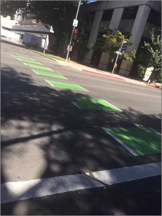
7 adhere to concrete or asphalt surfaces, epoxies are sensitive to moisture and temperature and may require long dry times. MMA may be installed at any temperature, is durable and dries quickly, but is more expensive than epoxy. The cost is about $8 $11 per square foot installed and it typically lasts an average of 5 years before needing reapplication. Thermoplastic, another type of durable pavement marking, is a type of plastic made from polymer resins that becomes a homogenized liquid when heated and hard when cooled. Thermoplastic can be preformed in specific shapes, such as tiles that can be assembled like a puzzle to color bicycle facilities. Thermoplastic can also be used for bicycle lane symbols, arrows, pavement legends, green color markings within lanes, and shared lane markings. This is referred to as Pre formed Thermoplastic. It comes in panels, and the panels are laid on the road and then heated. It is very easy to cover large areas (like colored bike lanes), and more durable than standard thermoplastic. Plus they have better friction than stand alone thermoplastic, so don t pose as great a risk of slipping under rainy/wet conditions. The cost is about $10 $14 per square foot installed and longevity averages 5 years. Thermoplastic tends to last longer than epoxy and is easier to apply then MMA. Retro reflective and antiskid materials can be applied or mixed throughout the plastic. The City of Beverly Hills has decided to use thermoplastic for the white lane striping on North Santa Monica Boulevard. Typical Bike Lane Striping The graphic below illustrates how the bicycle lanes will be striped as they approach and cross a typical intersection on NSMB. The graphic illustrates the latest approach to carrying the bicycle lanes across the intersection in dashed segments. The dashed green areas indicate the areas where there are potential conflicts between bicycles and motor vehicles, where vehicles may be crossing the bike lanes turning into our out of a side street, alley or driveway. 4
8 Why the Entire Bike Lane Is Not Green In years past, cities have typically colored the entire length of a bicycle lane green. This has resulted in some costly maintenance expenses. The more recent trend is to just color the areas of a bicycle lane where potential conflicts with vehicles may occur. This includes 100 of the approach to each intersection where right turning vehicles may have to merge into the bicycle lane to prepare for their right turn, as well as the width of a cross street intersection where vehicles may cross the bicycle lane turning into or out of the side street or proceeding straight across the intersection. At each intersection, there is also a short (20 ) segment of solid green bicycle lane on the far side of the intersection which is designed to alert motorists turning onto NSMB that there is a bicycle lane along the street adjacent to the curb. This reduces ongoing maintenance costs and calls attention to drivers where they need to be most cautious in looking out for bicyclists. In a typical 300 block in Beverly Hills, this would reduce the amount of green pavement by about one third, with even greater savings in the eastbound direction where there are few intersecting streets on the south side of the street east of Rexford Drive. The difference in installation cost using green paint would be about $30,000 to paint the entire length of the lanes compared to about $10,000 to color just the conflict points at 31 intersection approaches. In Themoplastic, it would be about $60,000 to add green to the entire bike lane and $20,000 to add it to the intersection conflict areas only. There are also options available that would not include the green dashes across the intersections and only use the color in the approaches to intersections where there are potential conflicts with right turning vehicles. In such cases, FHWA recommends and cities typically use dashed white lines and/or sharrow symbols to denote the path of bicyclists through the intersection. Bicycle Lane Striping at Complex Intersections At several intersections along NSMB, the typical intersection design above will require modification to accommodate additional vehicular travel lanes and merging areas. At Wilshire Blvd., there is a separate right turn lane on the westbound approach. At Beverly/Palm, there is a separate right turn lane on the eastbound approach and dual left turn lanes from Beverly to westbound NSMB. The eastbound approach to the Doheny/Melrose intersection is complicated by the addition of a through lane to Melrose and the merging of vehicles from eastbound Civic Center Drive. The design treatments at these intersections could require bicyclists to share lanes with vehicles as they pass through the intersections. Graphics illustrating these three intersection treatments are located in Appendix 4. At Wilshire Blvd., there is sufficient roadway width to allow the westbound bicycle lane to be located between the through lanes and the right turn only lane. At the Beverly/Palm intersection, there is currently a dedicated right turn only lane in the eastbound direction and the rest of the lanes are shifted toward the north side of the roadway. In order to maintain this dedicated right turn only lane, the bike lanes would have to end in advance of the intersection and bicyclists would share the road with vehicles as they approach and pass through the intersection. This treatment is in place on Burton Way at Doheny Drive and Robertson Boulevard. Iteris recommends that a safer design for bicyclists would maintain the westbound bicycle lane through the intersection and would create a shared bicycle/right turn lane in the eastbound direction. This shared lane will be approximately 11 wide with a 3 wide section of dashed green, indicating a path for bicyclists and a right 5
9 turn arrow in the 8 portion of the lane. The California Vehicle Code allows right turning vehicles to share the bicycle lane in the approach to an intersection. Implementing this shared bicycle/right turn lane would require that the right turn arrow on eastbound NSMB be removed so that drivers are not given a green arrow during the westbound Beverly Boulevard phase of the signal cycle because there could be a bicyclist stopped in the lane waiting to proceed east in the bicycle lane. The No Right Turn on Red sign could be removed to allow vehicles to turn right during the westbound Beverly Boulevard phase if no bicyclist is waiting in the shared lane. At the Doheny/Melrose intersection, Iteris recommends a design that carries the bicycle lane to Doheny between the eastbound NSMB through lanes and the lane that veers to the right onto Melrose Avenue. Traffic bound for Melrose would need to merge across the bike lane. Vehicles entering NSMB from Civic Center Drive that are bound for eastbound NSMB would also need to merge across the bike lane. Bicycle Lanes between Wilshire and Moreno Drive (West City Limit) Although the construction of NSMB west of Wilshire Boulevard is not included in the current phase of construction, preparation of the plans for that eventual reconstruction is part of the current design contract. The bicycle lanes west of Wilshire Boulevard will be similar to those east of Wilshire, but will have to take into consideration driveways at the hotels and the connection to bicycle lanes in Los Angeles in Century City. The planned roadway width in this section of NSMB when the two north side developments are complete and have implemented their frontage improvements is 64 feet. The graphic below illustrates the cross section that will be implemented west of Wilshire when the development projects are completed. Coordination with LADOT will be required to determine how to design the lanes through the crossover intersection near Moreno Drive. 6
10 Recommendations Based on the discussion included in the technical memorandum above, the consultant design team recommends the following: Color Green applied in conflict areas only (not the entire length of the lanes) Paint type Thermoplastic due to its longevity and consistency with the rest of the striping on NSMB. The City of Santa Monica has had good success with pre formed thermoplastic when constructing green colored bike lanes. Coordination with LADOT and West Hollywood City of Beverly Hills staff and consultants should meet with adjacent jurisdictions to coordinate the lane transitions at each end of the NSMB Reconstruction Project Final details of intersections to be determined in Final Design As the final design plans are revised, the consultant team should meet with City staff to confirm the details of intersection striping 7
11 Appendix 1: California Traffic Control Devices Committee Process Diagram
12 Example of Process for Requesting and Conducting Experimentations for New Traffic Control Devices in California Requesting jurisdiction submits request to CTCDC CTCDC will discuss & review during the Quarterly meeting Rejected Approved Would ask to receive approval from the FHWA First if it would reduce std. Requesting jurisdiction installs experimental traffic control device Evaluate experimental traffic control device Requesting jurisdiction provides semi-annual report to CTCDC Requesting jurisdiction provides CTCDC a final report Yes CTCDC reviews final report Further Experimentation required CTCDC accepts final report CTCDC rejects final report No CTCDC recommends Caltrans to develop a policy for the new traffic control device Caltrans develops the new traffic control device policy & brings it back to the CTCDC for discussion in an open public Caltrans rejects CTCDC recommendations and write back to the CTCDC their justifications Jurisdiction restores experiment site to original condition Caltrans adopts the policy and post on the CA MUTCD website until the future update of the CA MUTCD
13 Appendix 2: Federal Highway Administration Memorandum on Painted Bicycle Lanes
14

15

16
17
18
19 Appendix 3: Photographs of Green Bicycle Lane Treatments


20

21 Appendix 4: Three Complex Intersections with Bike Lanes

22 WILSHIRE BOULEVARD 20' 20' BIKE LANE BEGINS SANTA MONICA BOULEVARD WALDEN DRIVE BIKE LANE CONTINUES TO ELM DRIVE 100' BIKE LANE CONTINUES TO PALM DRIVE


23 BIKE LANE BEGINS BEFORE ELM DRIVE MAPLE DRIVE SANTA MONICA BOULEVARD PALM DRIVE HILLCREST ROAD 5' 11' 5' 10.5' ' 11' 5' 11' 10.5' 10' 11' 10.5' 5' ' 10.5' 10.5' 8' 10.5' 10' 10.5' 11' 5' 10.5' 10' 10.5' 11' 5' 6% 8.33% BIKE LANE CONTINUES TO WILSHIRE BLVD BIKE LANE ENDS SHARED BIKE BEGINS BIKE LANE BEGINS BIKE LANE CONTINUES TO DOHENY DRIVE

24 BIKE LANE BEGINS BIKE LANE CONTINUES TO HILLCREST ROAD 4% SANTA MONICA BOULEVARD BIKE LANE CONTINUES TO PALM DRIVE DOHENY DRIVE 4.5% % BIKE LANE ENDS SHARED BIKE BEGINS 3.5%

25 BIKE LANE CONTINUES TO BEVERLY DRIVE CANON DRIVE 20' SANTA MONICA BOULEVARD 5% % % % 2% % 100' TC 265.XX FL TC FL 100' FS 2% > 2% > 5.4% > TW FS TW FS TW FS < 5.7% 2% > FL TC FL 20' BIKE LANE BEGINS BIKE LANE CONTINUES TO CRESCENT DRIVE
AGENDA REPORT. Subject: CONSIDERATION OF SANTA MONICA BOULEVARD BLUE RIBBON COMMITTEE RECOMMENDATIONS
 Item Number: To: From: F i AGENDA REPORT Honorable Mayor & City Council Susan Healy Keene, AICP, Director of Community Development Aaron Kunz, AICP, Deputy Director of Transportation Subject: CONSIDERATION
FEDERAL HIGHWAY ADMINISTRATION APPLICATION
 FEDERAL HIGHWAY ADMINISTRATION APPLICATION REQUEST FOR PERMISSION TO EXPERIMENT WITH A BICYCLE BOX INTERSECTION TREATMENT Submitted by: City of Columbus Department of Public Service Date: June 26, 2009
CITY OF ELK GROVE CITY COUNCIL STAFF REPORT
 CITY OF ELK GROVE CITY COUNCIL STAFF REPORT AGENDA ITEM NO. 10.3 AGENDA TITLE: Bike Lane Installation Project Update MEETING DATE: April 26, 2017 PREPARED BY: Ryan D. Chapman P.E., Traffic Engineer DEPARTMENT
CITY OF LOS ANGELES INTER-DEPARTMENTAL MEMORANDUM
 CITY OF LOS ANGELES INTER-DEPARTMENTAL MEMORANDUM Date: April 1, 219 To: Honorable City Council c/o City Clerk, Room 395, City Hall Attention: Honorable Mike Bonin, Chair, Transportation Committee From:
City of Beverly Hills North Santa Monica Blvd Reconstruction. Community Meeting Presentation September 30 and October 1, 2015
 City of Beverly Hills North Santa Monica Blvd Reconstruction Community Meeting Presentation September 30 and October 1, 2015 1 Project Description Complete reconstruction of boulevard (pavement, curbs,
Dear Mr. Tweed: Sincerely, Min Zhou, P.E. Vice President
 December 17, 2012 Mr. Steve Tweed City of Long Beach, Department of Public Works Traffic & Transportation Bureau, 10 th Floor City Hall 333 West Ocean Boulevard Long Beach, CA 90802 Subject: Broadway and
Active Transportation Facility Glossary
 Active Transportation Facility Glossary This document defines different active transportation facilities and suggests appropriate corridor types. Click on a facility type to jump to its definition. Bike
Colored Bike Lanes Request to Experiment
 Coloured Lane 1 of 5 Colored Bike Lanes Request to Experiment I. Background Since the publication of Chicago s Bike Lane Design Guide in 2002, Chicago has been considered by many to be at the forefront
Appendix T CCMP TRAIL TRAFFIC & TRANSPORTATION DESIGN STANDARD
 Appendix T CCMP 3.3.4 TRAIL TRAFFIC & TRANSPORTATION DESIGN STANDARD 3.3.4 Trail Traffic and Transportation Design Multi-use trails have certain design standards, which vary depending on the agency that
Coquitlam Cross-town Bike Route Improving Bicycle Facilities in a Mature Suburban Environment
 Coquitlam Cross-town Bike Route Improving Bicycle Facilities in a Mature Suburban Environment Sarah Rocchi, Vice-President, Projects, Opus International Consultants (Main Presenter) Catherine Mohoruk,
2.0 LANE WIDTHS GUIDELINE
 2.0 LANE WIDTHS GUIDELINE Road Engineering Design Guidelines Version 2.0.1 May 2018 City of Toronto, Transportation Services City of Toronto Page 0 Background In early 2014, Transportation Services initiated
UPDATED AGENDA. CITY HALL 455 North Rexford Drive 4th Floor Conference Room A. Beverly Hills, CA Tuesday, December 12, :00 PM AGENDA
 UPDATED AGENDA Beverly Hills City Council Liaison I Traffic & Parking Commission Committee will conduct a Special Meeting, at the following time and place, and will the agenda listed below: address CITY
Appendix 3 Roadway and Bike/Ped Design Standards
 Appendix 3 Roadway and Bike/Ped Design Standards OTO Transportation Plan 2040 4/20/2017 Page A3-1 Adopted Standards The adopted OTO Design Standards and Major Thoroughfare Plan are contained herein.
Cycle Track Design Best Practices Cycle Track Sections
 Design Best Practices Sections It is along street segments where the separation and protection methods of cycle tracks offer more comfort than conventional bicycle lanes, and are more attractive to a wide
CITY OF LOMITA CITY COUNCIL REPORT
 CITY OF LOMITA CITY COUNCIL REPORT TO: FROM: City Council Ryan Smoot, City Manager Item No. SCH 12 PREPARED BY: Mark A. McAvoy, P.E., Public Works Director/City Engineer MEETING DATE: August 1, 2017 SUBJECT:
On Road Bikeways Part 1: Bicycle Lane Design
 On Road Bikeways Part 1: Bicycle Lane Design Presentation by: Nick Jackson Bill Schultheiss, P.E. September 04, 2012 FOLLOW THE CONVERSATION ON TWITTER Toole Design Group is live tweeting this webinar
APPENDIX A: Complete Streets Checklist DRAFT NOVEMBER 2016
 APPENDIX A: Complete Streets Checklist DRAFT NOVEMBER 2016 Complete Streets Checklist MetroPlan Orlando s Complete Streets Checklist is an internal planning tool for staff to further implementation of
DEPARTMENT OF ENVIRONMENTAL SERVICES. North Harrison Street (Lee Highway to Little Falls Road) Comparative Analysis. Prepared for:
 Comparative Analysis. Prepared for:") DEPARTMENT OF ENVIRONMENTAL SERVICES North Harrison Street (Lee Highway to Little Falls Road) Comparative Analysis Prepared for: Arlington County Department of Environmental Services 2100 Clarendon Boulevard,
DEPARTMENT OF ENVIRONMENTAL SERVICES North Harrison Street (Lee Highway to Little Falls Road) Comparative Analysis Prepared for: Arlington County Department of Environmental Services 2100 Clarendon Boulevard,
In 2014, the number of traffic fatalities in the United States reached its lowest level at. Bicycle Collisions. Effective in Reducing
 CASE STUDY Pierre Aden/shutterstock.com Countermeasures Prove Effective in Reducing Bicycle Collisions By Nazir Lalani, P.E. and Kristopher Gunterson In 2014, the number of traffic fatalities in the United
DRAFT FOR DISCUSSION PURPOSED ONLY, 10/26/13 MOBILITY PLAN UPDATE DESIGN TOOLBOX
 DRAFT FOR DISCUSSION PURPOSED ONLY, 10/26/13 MOBILITY PLAN UPDATE DESIGN TOOLBOX Tool #1: Bike Lane Portion of the roadway designated for preferential use by bicyclists. One-way facilities that typically
SAN FRANCISCO MUNICIPAL TRANSPORTATION AGENCY
 THIS PRINT COVERS CALENDAR ITEM NO. : 10.3 DIVISION: Sustainable Streets Division BRIEF DESCRIPTION: SAN FRANCISCO MUNICIPAL TRANSPORTATION AGENCY Approving traffic and parking modifications to install
Pavement Markings (1 of 3)
") Pavement Markings (1 of 3) DESCRIPTION AND DEFINITION Disadvantages Relatively high cost (over typical Crash reduction as yet unknown painted edge line) No tactile effect The STOP AHEAD pavement marking
Pavement Markings (1 of 3) DESCRIPTION AND DEFINITION Disadvantages Relatively high cost (over typical Crash reduction as yet unknown painted edge line) No tactile effect The STOP AHEAD pavement marking
Appendix C. Bicycle Route Signage
 Appendix C Bicycle Route Signage This page intentionally left blank. APPENDIX C - BICYCLE ROUTE AND WAYFINDING SIGNAGE Bicycle route signs are wayfinding signs that guide bicyclists along preferred, designated
Windy Ridge Elementary School
 Windy Ridge Elementary School SCHOOL ROUTE PLAN For WINDY RIDGE ELEMENTARY SCHOOL LOCATION 54 ORANGE COUNTY Prepared for: ORANGE COUNTY SCHOOL ASSESSMENT PROGRAM ORANGE COUNTY PUBLIC WORKS Traffic Engineering
REPORT TO MAYOR AND COUNCIL
 F.4 REPORT TO MAYOR AND COUNCIL PRESENTED: SEPTEMBER 12, 2016 - REGULAR AFTERNOON MEETING REPORT: 16-85 FROM: ENGINEERING DIVISION FILE: 5460-13-20-005 SUBJECT: RAINBOW CROSSWALK AT GLOVER ROAD AND MAVIS
Lessons Learned from Cycle Tracks (Class IV Bikeways) Design Practice
 Design Practice") Lessons Learned from Cycle Tracks (Class IV Bikeways) Design Practice By: Min Zhou, P.E., Principal/Vice President KOA Corporation 1 What is a Cycle Track (Class IV) TYPICAL BIKEWAY CLASSIFICATION CLASS
Lessons Learned from Cycle Tracks (Class IV Bikeways) Design Practice By: Min Zhou, P.E., Principal/Vice President KOA Corporation 1 What is a Cycle Track (Class IV) TYPICAL BIKEWAY CLASSIFICATION CLASS
Dr. M.L. King, Jr. Street North Complete Streets Resurfacing Opportunities HOUSING, LAND USE, AND TRANSPORTATION COMMITTEE MARCH 22, 2018
 Dr. M.L. King, Jr. Street North Complete Streets Resurfacing Opportunities HOUSING, LAND USE, AND TRANSPORTATION COMMITTEE MARCH 22, 2018 What s Happening The City plans to mill and resurface Dr. M.L.
BEVERLY HILLS STAFF REPORT. To: From: Subject: INTRODUCTION DISCUSSION. Meeting Date: August 7, 2018
 BEVERLY HILLS 9.4 STAFF REPORT Meeting Date: August 7, 218 To: From: Subject: Honorable Mayor & City Council Ryan Gohlich, AICP, City Planner / Assistant Director of Community Development Commemorative
Chapter 4 TOOLBOX AND SAMPLE BIKE BOULEVARD LAYOUT
 Chapter 4 TOOLBOX AND SAMPLE BIKE BOULEVARD LAYOUT OVERVIEW This chapter describes a cohesive set of strategies to create a bicycle boulevard, namely to make streets safer and more efficient for bicycle
SAN FRANCISCO MUNICIPAL TRANSPORTATION AGENCY
 THIS PRINT COVERS CALENDAR ITEM NO. : 12 DIVISION: Sustainable Streets BRIEF DESCRIPTION: SAN FRANCISCO MUNICIPAL TRANSPORTATION AGENCY Approving various bicycle improvements and traffic modifications
Meeting of March 5, Traffic Engineering Activities October 2014 through February 2015 (Bolded: New activities for this Quarter)
") BEVERLY HILLS CITY OF BEVERLY HILLS TRAFFIC & PARKING COMMISSION Meeting of March 5, 2015 TO: Traffic & Parking Commission FROM: Bijan Vaziri, Senior Transportation Engineer SUBJECT: Traffic Engineer Quarterly
BEVERLY HILLS CITY OF BEVERLY HILLS TRAFFIC & PARKING COMMISSION Meeting of March 5, 2015 TO: Traffic & Parking Commission FROM: Bijan Vaziri, Senior Transportation Engineer SUBJECT: Traffic Engineer Quarterly
Crosswalk Policy Revisions & Pedestrian & Bicycle Connection Plans. Presentation to Sanibel City Council July 16, 2013
 Crosswalk Policy Revisions & Pedestrian & Bicycle Connection Plans Presentation to Sanibel City Council July 16, 2013 Outline Crosswalk Policy Revisions Minimum Standards Goals and Objectives Pedestrian
REGIONAL BICYCLE AND PEDESTRIAN DESIGN GUIDELINES
 REGIONAL BICYCLE AND PEDESTRIAN DESIGN GUIDELINES November 16, 2011 Deb Humphreys North Central Texas Council of Governments Bicycle and Pedestrian Advisory Committee Snapshot of the Guide 1. Introduction
Project Team Project Background Project Improvements Proposed Construction Approach Traffic Impact and Mitigation Next Steps Questions/Comments
 Project Team Project Background Project Improvements Proposed Construction Approach Traffic Impact and Mitigation Next Steps Questions/Comments 1 City of Beverly Hills Samer Elayyan, Project Manager Mark
City of Memphis On-Street Parking Modification Guidelines
 City of Memphis Effective Date: December 1, 2013 Bicycle/Pedestrian Program 125 N. Main Street Memphis, TN 38103 (901) 576-6710 www.bikepedmemphis.com City of Memphis Executive Summary It is current practice
Complete Streets Policy DAVID CRONIN, P.E., CITY ENGINEER
 Complete Streets Policy DAVID CRONIN, P.E., CITY ENGINEER Complete Streets City Commission adopted a Complete Streets policy in 2012 Complete Streets are road networks that are designed for all users:
A Insert design-related public comment here.
 Design Guidelines A Insert design-related public comment here. - Public Comment, 2016 This regional plan focuses on connecting regional nodes, such as Wilmington, NC (Gary Shell Cross-City Trail shown
Caltrans Sloat Boulevard Pedestrian Safety Project Response to Community Questions, Comments & Concerns
 Caltrans Sloat Boulevard Pedestrian Safety Project Response to Community Questions, Comments & Concerns Revised: May 10, 2016 The California Department of Transportation (Caltrans) is planning various
Omaha s Complete Streets Policy
 Omaha s Complete Streets Policy (Adopted August 2015) VISION To create great places and enhance our quality of life, the City of Omaha will provide safe, accessible streets for all users. Complete Streets
SANTA MONICA BOULEVARD CORRIDOR
 CIRCULATION ELEMENT WHITE PAPER NO. 3 SANTA MONICA BOULEVARD CORRIDOR INTRODUCTION From the 1930s to the beginning of Los Angeles freeway era, Santa Monica Boulevard, (previously Route 66, the Beverly
City of Roseville Section 13 Design Standards. _Bikeways January 2016 SECTION 13 BIKEWAYS
 SECTION 13 BIKEWAYS 13-1 GENERAL The City of Roseville bikeway standards are designed to insure that transportation and recreational bikeways are constructed in a manner that would provide a safe and comfortable
Orange Center Elementary School
 Drag and drop pic and stretch/crop to the limits of the blue rectangle (delete this text box) Orange Center Elementary School Drag and drop pic and stretch/crop to the limits of the blue rectangle (delete
Toronto and East York Community Council. Director, Transportation Services, Toronto and East York District
 No Turn on Red Regulations STAFF REPORT ACTION REQUIRED Date: June 1, 2010 To: From: Toronto and East York Community Council Director, Transportation Services, Toronto and East York District Wards: Trinity
10.0 CURB EXTENSIONS GUIDELINE
 10.0 CURB EXTENSIONS GUIDELINE Road Engineering Design Guidelines Version 1.0 March 2017 City of Toronto, Transportation Services City of Toronto Page 0 Background In early 2014, Transportation Services
Zlatko Krstulich, P.Eng. City of O9awa
 Zlatko Krstulich, P.Eng. City of O9awa 1. Introduction to the Ontario Traffic Manual Series 2. What is OTM Book 18: Bicycle Facilities? 3. Study / Committee Team Members 4. Brief overview of the content
Appendices. Appendix A: Design Guidelines
 Appendix A: Design Guidelines This appendix is intended to assist in the selection and design of bicycle facilities. The following pages pull together best practices by facility type from public agencies
Appendix D: Planning Level Cost Calculator
 Appendix D: Planning Level Cost Calculator Network Costs by Facility Type Facility Type Total Miles of Facility Total Number of Intersections Cost per feature or per mile Total Cost Bicycle Boulevard 52.14
Metro Bike/Bus Interface Study
 Metro Bike/Bus Interface Study Agenda 1. Background & Process 2. Corridors & Metrics 3. General Findings 4. Training Recommendations 5. Design Guidelines 6. Questions L.A. County Bus Service LA Metro 1,433
TOWN OF PORTLAND, CONNECTICUT COMPLETE STREETS POLICY
 TOWN OF PORTLAND, CONNECTICUT COMPLETE STREETS POLICY I. VISION, GOALS & PRINCIPLES VISION To improve the streets of Portland making them safer and more accessible for all users including pedestrians,
Chapter 3 DESIGN SPECIFICATIONS
 Brampton PathWays Planning and Design Guidelines 27 Chapter 3 DESIGN SPECIFICATIONS 3.1 CLASS 1 MULTI-USE PATH Off-road multi-use trails are the backbone of the Brampton PathWays Network. They are typically
DRAFT. Scholls Ferry Road Conceptual Design Plan Technical Memorandum Multi-Modal Examples. Multnomah County 1600 SE 190th Avenue Portland, OR 97233
 Technical Memorandum Multi-Modal Examples Prepared for 1600 SE 190th Avenue Portland, OR 97233 December 2008 CITATION This project is partially funded by a grant from the Transportation and Growth Management
Appendix C. TRAFFIC CALMING PROGRAM TOOLBOX
 Appendix C. TRAFFIC CALMING PROGRAM TOOLBOX PHASE I...2 Do Not Enter Sign...3 One-Way Sign...4 Turn Prohibition...5 Pavement Markings...6 Speed Monitoring Trailer...7 Neighborhood Speed Watch...8 Police
UPTOWN REGIONAL BIKE CORRIDORS PROJECT SAN DIEGO ASSOCIATION OF GOVERNMENTS
 UPTOWN REGIONAL BIKE CORRIDORS PROJECT SAN DIEGO ASSOCIATION OF GOVERNMENTS SUMMARY REPORT: COMMUNITY UPDATE MEETING February 6, 2014 6 8:30 p.m. Roosevelt Middle School Library 3366 Park Blvd, San Diego
AUTHORIZE BID ADVERTISEMENT
 STAFF REPORT MEETING DATE: May 17, 2016 TO: City Council FROM: Petr Skala, Assistant Engineer PRESENTER: Russell Thompson, Public Works Director 922 Machin Avenue Novato, CA 94945 415/ 899-8900 FAX 415/
Appendix F: Wayfinding Protocol and Best Practices
 Appendix F: Wayfinding Protocol and Best Practices Table of Contents Introduction... 259 Current Practice... 259 Policy and Regulatory Framework... 260 Best Practices... 262 Chicago, IL... 262 Seattle,
CITY OF BEVERLY HILLS TRAFFIC & PARKING COMMISSION
 CITY OF BEVERLY HILLS TRAFFIC & PARKING COMMISSION Meeting of TO: FROM: Bijan Vaziri, Senior Transportation Engineer SUBJECT: Traffic Engineer Quarterly Report Traffic Engineering Activities January 2014
The 2012 AASHTO Bike Guide: An Overview
 The 2012 AASHTO Bike Guide: An Overview Presentation by: Jennifer Toole, AICP, ASLA Peter Lagerwey August 10, 2012 {Enter Module Name on Master Slide} WEBINAR #1: OVERVIEW OF 2012 AASHTO BIKE GUIDE Today
On Monday, December 12, 2011, you will be briefed on Pavement Markings. The material is attached for your review.
 Memorandum CITY OF DALLAS DATE December 9, 2011 TO subject Honorable Members of the Transportation & Environment Committee: Linda Koop (Chair), Sheffie Kadane (Vice Chair), Pauline Medrano, Vonciel Jones
Overview. Illinois Bike Summit IDOT Complete Streets Policy Presentation. What is a Complete Street? And why build them? And why build them?
 Overview Illinois Bike Summit IDOT Complete Streets Policy Presentation Aren Kriks, P.E. District One Bicycle Coordinator and Bureau of Programming Project Engineer History of Complete Streets IDOT Policy
Chapter 7: Six-Step Implementation Process
 Chapter 7: Six-Step Implementation Process The purpose of this chapter is to explain how the perspectives of all stakeholders interested in or affected by existing or future streets can be incorporated
PREFORMED THERMOPLASTIC BICYCLE & PEDESTRIAN MARKINGS
 PREFORMED THERMOPLASTIC BICYCLE & PEDESTRIAN MARKINGS www.ennisflint.com Durable pavement markings are something to smile about! For the municipality it saves money by stretching budget dollars related
Chapter 6: Along the Street
 Chapter 6: Along the Street This section describes the types of infrastructure that should be in place along school routes to make walking and bicycling to school safer. Sidewalks In communities with sidewalks,
Bikeways Network and Facilities
 Findings from the bicycle survey showed a high bicycle use and demand for on and off road bikeway facilities. Currently, the City has 185 miles of bike lanes, 40 miles of signed routes to connect the network
MOBILITY WORKSHOP. Joint City Council and Transportation Commission May 5, 2014
 MOBILITY WORKSHOP Joint City Council and Transportation Commission May 5, 2014 Review of General Plan M-1 Develop world-class transit system M-3 Maintain/enhance pedestrian-oriented City M-4 Create comprehensive
900 BICYCLE FACILITIES Traffic Engineering Manual
 TABLE OF CONTENTS Part 9 - BICYCLE FACILITIES 900 GENERAL... 9-3 900-1 General Background... 9-3 900-2 Designated Bicycle Routes... 9-3 901 SIGNINGS... 9-4 902 MARKINGS... 9-4 902-1 General... 9-4 902-2
Item No. 14 Town of Atherton
 Item No. 14 Town of Atherton CITY COUNCIL STAFF REPORT CONSENT AGENDA TO: THROUGH: FROM: HONORABLE MAYOR AND CITY COUNCIL GEORGE RODERICKS, CITY MANAGER MICHAEL KASHIWAGI, COMMUNITY SERVICES DIRECTOR MARTY
Bay to Bay Boulevard Complete Streets Project
 Bay to Bay Boulevard Complete Streets Project Dale Mabry Highway to Bayshore Boulevard February 08, 2018 Photo Source: Tampa Bay Times Alessandra Da Pra Meeting Format Introduction Resurfacing Information
Improving Cyclist Safety at the Dundas Street West and Sterling Road Intersection
 STAFF REPORT ACTION REQUIRED Improving Cyclist Safety at the Dundas Street West and Sterling Road Intersection Date: August 17, 2012 To: From: Wards: Reference Number: Public Works and Infrastructure Committee
City of El Cerrito San Pablo Avenue Specific Plan. Capital Improvement Program
 City of El Cerrito San Pablo Avenue Specific Plan Capital Improvement Program May 2015 San Pablo Avenue Intersection Improvements San Pablo Avenue and Hill Street/Eastshore Boulevard Background Existing
MARTIN LUTHER KING JR. WAY
 OCTOBER 2011 40 Vision and Goals The Martin Luther King, Jr. Way Illustrative Master Plan that follows has been developed through a process of community involvement. It expresses a long term vision for
NJDOT Complete Streets Checklist
 Background The New Jersey Department of Transportation s Complete Streets Policy promotes a comprehensive, integrated, connected multi-modal network by providing connections to bicycling and walking trip
Harbord Street and Hoskin Avenue Bicycle Lane Upgrades
 STAFF REPORT ACTION REQUIRED and Bicycle Lane Upgrades Date: April 22, 2014 To: From: Wards: Reference Number: Public Works and Infrastructure Committee General Manager, Transportation Services 19 and
Appendix A. Knoxville TPO Greenway Signage Guidelines. Appendix A: Knoxville TPO Greenway Signage Guidelines Knox to Oak Ridge Greenway Master Plan
 Appendix A Knoxville TPO Greenway Signage Guidelines 75 Overview: Adequate signing and marking are essential on shared-use paths, especially to alert bicyclists to potential conflicts and to convey regulatory
Meadow Woods Elementary School
 Drag and drop pic and stretch/crop to the limits of the blue rectangle (delete this text box) Meadow Woods Elementary School Drag and drop pic and stretch/crop to the limits of the blue rectangle (delete
MINNEAPOLIS PARK & RECREATION BOARD DRAFT TRAIL DESIGN STANDARDS FOR: SIGNS AND PAVEMENT MARKINGS
 MINNEAPOLIS PARK & RECREATION BOARD DRAFT TRAIL DESIGN STANDARDS FOR: SIGNS AND PAVEMENT MARKINGS October 14, 2014 CHANGE LOG Additions and changes to this document should be summarized on this page and
900 BICYCLE FACILITIES Traffic Engineering Manual
 TABLE OF CONTENTS Part 9 - BICYCLE FACILITIES 900 GENERAL... 9-3 900-1 General Background... 9-3 900-2 Designated Bicycle Routes... 9-3 901 SIGNING... 9-4 901-1 General... 9-4 901-2 Bicycle 3-Foot Clearance
Protected Bike Lanes in San Francisco Mike Sallaberry SFMTA NACTO Workshop - Chicago IL
 Protected Bike Lanes in San Francisco Mike Sallaberry SFMTA 10 14 2011 NACTO Workshop - Chicago IL San Francisco 2 nd Highest Density in the U.S. 47 square miles Mild Climate Market Population ~810,000
March 2008 FINAL DRAFT. Supplemental Bikeway Design Guidelines
 March 2008 FINAL DRAFT Supplemental Bikeway Design Guidelines Prepared for: Marin County Department of Public Works Marin County Unincorporated Area Bicycle and Pedestrian Master Plan Prepared by: Alta
REVOCABLE PERMIT FOR STREET BANNER APPLICATION PACKAGE
 Development Engineering 300 Richards Blvd., 3rd Floor Sacramento, CA 95811 Engineering Services Division REVOCABLE PERMIT FOR STREET BANNER APPLICATION PACKAGE Phone: 916-808-8300 Fax: 916-808-1984 Preparation
Traffic Safety Plan Second Avenue
 Traffic Safety Plan Second Avenue April 2017 City of Greater Sudbury Roads & Transportation Services Division Overview Overview... 2 1.0 Project Overview... 4 2.0 Pedestrian Safety... 4 2.1 Current Infrastructure...
City of Coronado Bicycle Map, Schools, Traffic Signals and Crossing Guard Locations
 City of Coronado Bicycle Map, Schools, Traffic Signals and Crossing Guard Locations Early Childhood Development Center Crossing Guard - AM Crossing Guard - PM Coronado Middle Village Elementary Coronado
CITY OF SIGNAL HILL Cherry Avenue Signal Hill, CA
 CITY OF SIGNAL HILL 2175 Cherry Avenue Signal Hill, CA 90755-3799 AGENDA ITEM TO: HONORABLE MAYOR AND MEMBERS OF THE CITY COUNCIL FROM: STEVE MYRTER, P. E. DIRECTOR OF PUBLIC WORKS SUBJECT: SPRING STREET
Public Information Centre
 WELCOME Public Information Centre Father Tobin Road Lougheed Middle School - Library Wednesday November 7, 2012 7:00 p.m.to 9:00 p.m. Please sign in Neighbourhood Traffic Calming Guide Background The City
Attachment 8: Fehr & Peers Supplemental Traffic Analysis (January 3, 2013)
") Attachment 8: Fehr & Peers Supplemental Traffic Analysis (January 3, 2013) FEHR~~ PEERS Date: January 3, 2013 MEMORANDUM To: From: Subject: Abe Leider, AICP CEP, Rincon Consultants, Inc. Tamar Fuhrer,
Attachment 8: Fehr & Peers Supplemental Traffic Analysis (January 3, 2013) FEHR~~ PEERS Date: January 3, 2013 MEMORANDUM To: From: Subject: Abe Leider, AICP CEP, Rincon Consultants, Inc. Tamar Fuhrer,
Planning Guidance in the 2012 AASHTO Bike Guide
 Planning Guidance in the 2012 AASHTO Bike Guide Presentation by: RJ Eldridge Peter Lagerwey August 22, 2012 WEBINAR 2: PLANNING GUIDANCE IN THE 2012 AASHTO BIKE GUIDE Today s Webinar Significant Updates
Bicycle-Specific Traffic Control Is it "Bicycle-Friendly"?
 Bicycle-Specific Traffic Control Is it "Bicycle-Friendly"? Richard C. Moeur, P.E. In the United States, the Uniform Vehicle Code and most state laws treat bicyclists as having much the same rights and
APPENDIX G SIGNAGE AND STRIPING SUPPLEMENT
 APPENDIX G SIGNAGE AND STRIPING SUPPLEMENT DOUGLAS COUNTY SIGNAGE AND STRIPING SUPPLEMENT TO DOUGLAS COUNTY ROADWAY DESIGN & CONSTRUCTION STANDARDS UPDATED MAY 2018 TABLE OF CONTENTS 1.00: GENERAL REQUIREMENTS...
SAN FRANCISCO MUNICIPAL TRANSPORTATION AGENCY
 THIS PRINT COVERS CALENDAR ITEM NO.: 10.3 DIVISION: Sustainable Streets BRIEF DESCRIPTION: SAN FRANCISCO MUNICIPAL TRANSPORTATION AGENCY Approving various traffic and parking modifications on Bay Street
Connecting cyclists to work. Syracuse Metropolitan Transportation Council
 Connecting cyclists to work Syracuse Metropolitan Transportation Council Overview Prepared at request: NYS Department of Transportation (NYSDOT) Project Achievements Target group Purpose Process Recommendations
CITY OF SARATOGA SPRINGS PEDESTRIAN CROSSING TOOLBOX
 CITY OF SARATOGA SPRINGS PEDESTRIAN CROSSING TOOLBOX This toolbox is to be used to guide pedestrian crossing improvements within the City of Saratoga Springs. Details for each crossing type are provided.
Shared Lane Markings: When and Where to Use Them. Mike Sallaberry, SFMTA Pro Walk/Pro Bike in Seattle September 4, 2008
 Shared Lane Markings: When and Where to Use Them Mike Sallaberry, SFMTA Pro Walk/Pro Bike in Seattle September 4, 2008 San Francisco Bicycle Route Network Bike Network: 208 Total Miles 31 Miles of Bike
Proposed Bridge Street East Bicycle Lanes Public Open House Thursday, April 27, 2017
 WELCOME Proposed Bridge Street East Bicycle Lanes Public Open House Thursday, April 27, 2017 Purpose of the Open House The purpose of this Open House is to gain public input on the bicycle lanes proposed
City of Vallejo Traffic Calming Toolbox
 City of Vallejo Traffic Calming Toolbox June 1, 2013 Final Table of Contents Introduction... 1 Non-Physical Devices... 3 High-Visibility Crosswalk... 3 In Pavement Lighted Crosswalk... 4 Rapid Flashing
Staff Report City of Manhattan Beach
 Agenda Item #: Staff Report City of Manhattan Beach TO: THROUGH: FROM: Honorable Mayor Wilson and Members of the City Council Geoff Dolan, City Manager Richard Thompson, Director of Community Development
2018 AASHTO BIKE GUIDE
 2018 AASHTO BIKE GUIDE Your presenter Rob Burchfield, PE NW Regional Engineering Director 35 years of experience in traffic engineering and bicycle facility design Toole Design Group Toole Design Group
What's in the 2012 California MUTCD for Pedestrians, Bicyclists, and School Areas?
 What's in the 2012 California MUTCD for Pedestrians, Bicyclists, and School Areas? CA MUTCD 2012 edits by John Ciccarelli Member, California Traffic Control Devices Committee Member, NCUTCD Bicycle Technical
Task 4 Wayfinding Elements, Placement and Technical Guidance 4.1 Wayfinding Elements
 1836 Blake Street Denver, CO 80202 720.524.7831 ww.altaplanning.com MEMO 3 Task 4 Wayfinding Elements, Placement and Technical Guidance 4.1 Wayfinding Elements Based on field reconnaissance, best practices
Chapter 5: Crossing the Street
 Chapter 5: Crossing the Street Whether walking or bicycling, a student s journey to school will more than likely require crossing one or more streets. Per the Safe Routes to School Guide, maintained by
CHAPTER 1 STANDARD PRACTICES
 CHAPTER 1 STANDARD PRACTICES OBJECTIVES 1) Functions and Limitations 2) Standardization of Application 3) Materials 4) Colors 5) Widths and Patterns of Longitudinal Pavement Marking Lines 6) General Principles
2014/2015 BIKE ROUTE PLAN 83 AVENUE PROTECTED BIKE LANE
 About the Project The City of Edmonton is planning a major bike route on the southside of Edmonton. The Strathcona Bike Route will connect the communities of Strathcona, Garneau and the University area,