A Study to Connect the Virginia Capital Trail to the Hampton Roads Region. Adopted by the HRTPO Board on July 20, 2017 (Updated on October 10, 2017)
|
|
|
- Alvin Summers
- 5 years ago
- Views:
Transcription


1 A Study to Connect the Virginia Capital Trail to the Hampton Roads Region Adopted by the HRTPO Board on July 20, 2017 (Updated on October 10, 2017) Y O RK RI V ER CH ES A PE A K E JA M ES RI V ER BA Y


2 October 10, 2017 Update: Figure 2 (Pg. 7) was modified to only reflect the Recommended Routes (not the Alternatives.) See Figure 11 (Pg. 25) for a map of the Recommended and Alternative Routes. Pg. 2
3 Introduction Pg. 3
4 Introduction Pg. 4
5 Introduction Pg. 5


6 Introduction FIGURE 1: STUDY AREA Pg. 6

7 Introduction FIGURE 2: RECOMMENDED ROUTES As shown above, the Recommended Routes connect the Virginia Capital Trail to Fort Monroe via the Peninsula and to the South Hampton Roads Trail via the Southside. For more detail on the Recommended and Alternative Routes, please visit the Interactive Web Map. Pg. 7


8 Introduction FIGURE 3: THE BIRTHPLACE OF AMERICA TRAIL HISTORY AND HERITAGE The map above illustrates several of the many historic and cultural sites along the Birthplace of America Trail Pg. 8


9 Introduction St. Luke s Church (circa 1682) Pg. 9


10 Introduction FIGURE 4: SHARED-USE PATH DESIGN GUIDELINES The guidelines above reflect design standards from AASHTO and VDOT. Source: Michael Baker International Pg. 10


11 Introduction FIGURE 5: FROM VISION TO REALITY, VIRGINIA CAPITAL TRAIL TIMELINE The Virginia Capital Trail. Source: VDOT and Michael Baker Int l Pg. 11


12 Introduction The Virginia Capital Trail. Source: VDOT Pg. 12


13 Introduction The vision for Fort Monroe includes active transportation facilities on McNair Drive and Gulick Drive (illustrative example above). Source: Fort Monroe Authority Pg. 13


14 Introduction The South Hampton Roads Trail in the City of Suffolk, locally referred to as the Suffolk Seaboard Coastline Trail. Source: South Hampton Roads Trail Facebook. Pg. 14
15 Input and Analysis Pg. 15


16 Input and Analysis FIGURE 6: PUBLIC INPUT ON DESTINATIONS AND POTENTIAL PATH SEGMENTS Pg. 16


 Pg.")


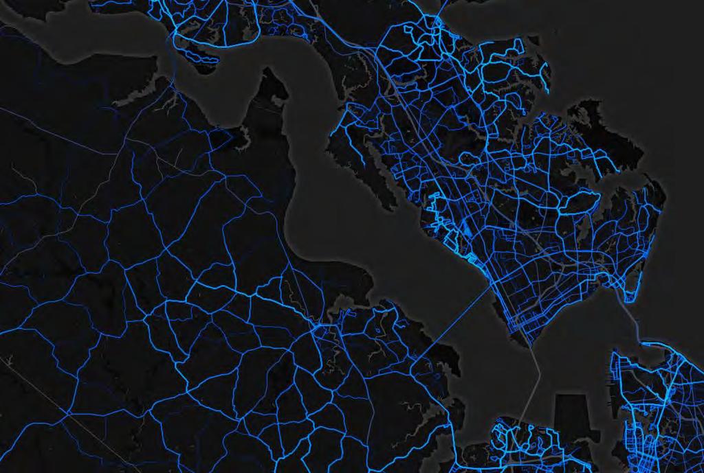
17 Input and Analysis Strava data were reviewed to identify popular existing routes for cyclists (example above) Pg. 17


18 Input and Analysis Boardwalk-style bridges, like those used on the Virginia Capital Trail (above), can be used to traverse wetland areas. Source: VDOT Pg. 18


19 Input and Analysis The existing retaining walls in the I-64 underpasses (like the Yorktown Road example above) would need to be reconfigured to accommodate a 10 shared-use path. The blue area above approximates the area of the retaining wall that would require modification. Pg. 19


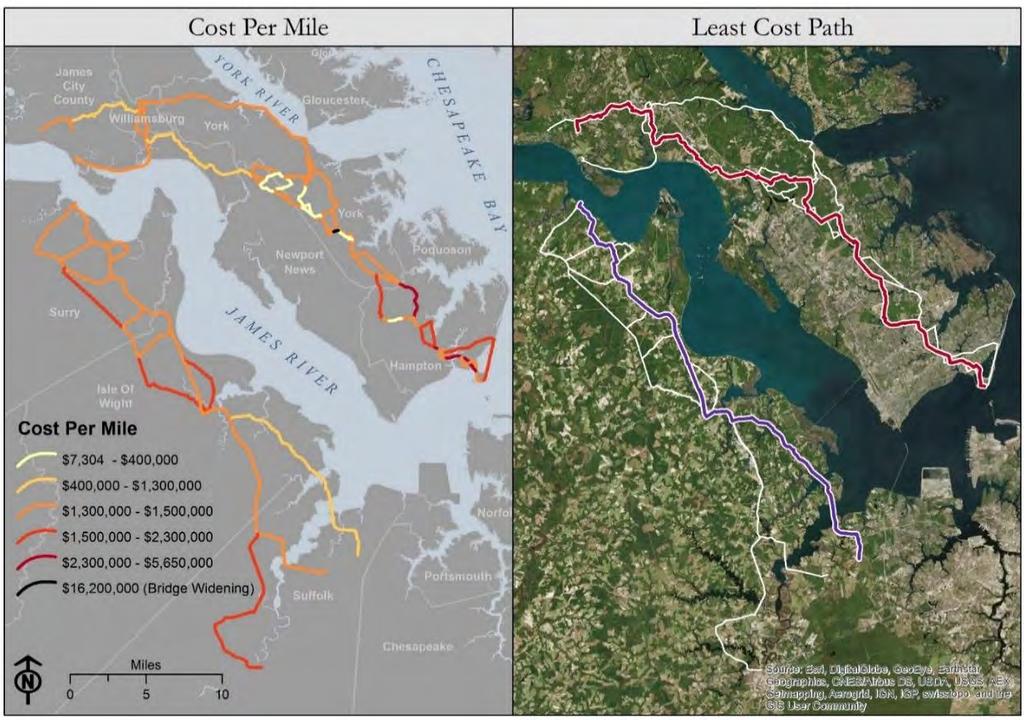
20 Input and Analysis FIGURE 7: PRELIMINARY COST ANALYSIS Cost estimates were developed for the various segments and used to help identify least-cost paths for the Peninsula and Southside. Pg. 20


21 Input and Analysis FIGURE 8: DEMAND ANALYSIS CRITERIA AND WEIGHTS A draft schematic showing how various demand generators contributed to the overall demand scoring process. Pg. 21


22 Input and Analysis FIGURE 9: THE HRT MAX 961 REGIONAL EXPRESS SERVICE The HRT MAX Route 961 offers regional express service and can connect trail users to Hampton, Newport News, Norfolk, and beyond. The HRT MAX Route 961 connects to the new Downtown Norfolk Transit Center. Source: gohrt.com Pg. 22


23 Input and Analysis FIGURE 10: ALL THINGS CONSIDERED PUBLIC INPUT, COST, AND DEMAND The public survey results, along with anticipated cost and demand, were some of the resources used to finalize the Recommended Route and the Alternatives. Pg. 23


24 Map Segments Pg. 24

25 Map Segments FIGURE 11: RECOMMENDED AND ALTERNATIVE ROUTES Pg. 25


26 Map Segments Birthplace of America Trail Study Key Elements Segment Map Elements: Number and description of map section, map key in bottom left overall view of the recommended route, alternate routes, existing trails, and any opportunities or constraints. See key for explanation of icons. The total cost estimate of this section of the recommended route. See breakdown by segment on next page, and cost estimates of alternative routes in appendix. The total length of this section of the recommended route, and how much of that is already built or funded. See breakdown by segment on next page. Location of this section within overall alignment. On second page, detail map and description of complicated areas Table showing data for each individual segment, including total length, existing or funded length, total cost, whether is is VDOT maintained, and whether it is part of an existing plan Map Icon Key: Bridge History Concern Park College Population School Transit Employment Right-of-Way Trail Connection Wetland Pg. 26

27 Map Segments 1. Capital Trail to Williamsburg Birthplace of America Trail Study Cost Length Location Recommended Concept $8.3 Mil Recommended Concept 1.1 Miles 6 Miles Complete/Funded 7.1 Miles To be Constructed Route Summary The Recommended Route begins at Jamestown High School on Route 5, travels north on Greensprings Plantation Drive, and then east on Monticello Avenue. At Veterans Park, the route follows Ironbound Road before eventually reconnecting to Monticello and traveling under Route 199. The route then follows Ironbound to Monticello and eventually follows Compton to the William & Mary campus before connecting to Historic Williamsburg via Jamestown Road and Francis Street. Segment Opportunities Includes several segments with existing or funded shared use paths. Provides access to the commercial area of New Town & Merchants Square, including restaurants and a bike shop. Provides direct access to William & Mary, (8,617 students). Allows users to access Jamestown and Colonial Williamsburg Segment Constraints From Ironbound Road, the Recommended Route crosses four ramps (two signalized and two unsignalized) at the Route 199 interchange. Futher study should consider appropriate warning signage, signalized trail crossings, repurposing the bike lanes and existing sidewalk as a shared-use path, and construction of a trail overpass over the southbound acceleration lane. Pg. 27
.")
28 Map Segments 1. Capital Trail to Williamsburg Birthplace of America Trail Study A Closer Look: Downtown Williamsburg The map (right) shows the Recommended Route s path into Colonial Williamsburg. The routing was recommended by William & Mary and Colonial Williamsburg as it minimizes environmental impacts and reduces conflicts in areas with high pedestrian traffic (Duke of Gloucester Street). - - Shared-use paths may not be feasible on several segments in this area. For example, Compton Drive is bounded by a small ridge on the roadway s west side a steep slope on the roadway s right side. In addition, right-of-way may be limited on Jamestown Road (existing bike lanes) and Francis Street. In the event that shared-use paths are infeasible, additional signage or traffic calming measures could reduce vehicular speeds and improve active transportation safety. Note: William & Mary has submitted a grant application to extend the sidewalks on Compton Drive to connect to Monticello Avenue. Segment Details: Segment Number From To Length (Miles) Existing/ Funded Portion Mainte nance Part of Existing Plan? Planninglevel Cost Estimate Rec-1A Greensprings Plantation Dr Greensprings Plantation Dr & John Tyler Mem Hwy (Rt 5) & Monticello Ave (Rt 5000) Local No $.9M Rec-1B Rec-1C Monticello Ave (Rt 5000) & Greensprings Plantation Dr Monticello Ave (Rt 321) & Ironbound Rd Monticello Ave (Rt 321) & Ironbound Rd Monticello Ave (Rt 321) & Ironbound Rd via Ironbound Rd Cost Notes Rec-1B: Existing shared-use path through Veterans Park Rec-1D: Funded shared-use path for.72 miles Mixed Yes $3.2M VDOT No $1.3M Rec-1D Monticello Ave (Rt 321) & Ironbound Rd W Francis St & S Henry St Mixed No $2.5M Rec-1E W Francis St & S Henry St Francis St & S England St VDOT No $.4M Total $8.3M Pg. 28


29 Map Segments 1. Capital Trail to Williamsburg Birthplace of America Trail Study Veterans Park, Williamsburg (Rec-1B) The route follows an existing path through Veterans Park to connect from Monticello Avenue to Ironbound Road Compton Drive, Williamsburg (Rec-1D) The route enters William & Mary campus on Compton Drive Pg. 29

 is a 14-foot asphalt roadway in good condition. WATA provides bus service/bike racks.")
30 Map Segments 2. Williamsburg to Yorktown Road Birthplace of America Trail Study Cost Length Location Recommended Concept $14.8 Mil Recommended Concept 0 Miles 11.5 Miles Complete/Funded 11.5 Miles To be Constructed Route Summary From Colonial Williamsburg, the Recommended Route follows South England Street to Carters Grove Country Road and then parallels Route 60 for a short stretch. After crossing Skiffes Creek, the route passes over Route 60 and the rail line and eventually follows Yorktown Road under I-64 before connecting to Jefferson Avenue and Newport News Park. Segment Opportunities Carters Grove Country Road (currently closed to the public/ vehicular traffic) is a 14-foot asphalt roadway in good condition. WATA provides bus service/bike racks. Offers opportunities for active transportation and economic development. Segment Constraints Carters Grove Road has several property owners (Colonial Williamsburg, Escalante, Kings Mill). Potential public use depends on coordination with existing/future property owners. The structural integrity of two short bridges over Halfway Creek and Grove Creek must be evaluated. Could potentially provide access to large regional employers, such as Busch Gardens. There are several barriers (natural and man-made) at the approach to I-64 (see next page). Pg. 30
 and is bound by a")
31 Map Segments 2. Williamsburg to Yorktown Road Birthplace of America Trail Study A Closer Look: The Approach to I-64 The US 60 crossing of Skiffe s Creek is currently 2 lanes (totaling 24-feet wide) and is bound by a narrow strip of grass area and guardrails. Further engineering analysis is needed to evaluate suitable bicycle/pedestrian accomodations. Further study should also evaluate potential alternatives for crossing US 60 and the adjacent rail line. Estimated cost: $5.2 million The I-64 underpass on the west side of Yorktown Road will likely require reconfiguration in order to accommodate a path between the bridge piers and the slope wall. A retaining wall will likely need to be installed, as well. Estimated cost: $600,000 Segment Details: Existing/ VDOT Part of Planninglevel Cost Segment Length From To Funded Maintained? Plan? Estimate Existing Number (Miles) Portion Rec-2A S England St & Francis St S England St & Pipeline Private No $2.5M Rec-2B S England St & Pipeline Carters Grove County Rd near Tolers Rd Private No $2.9M Rec-2C Carters Grove County Rd near Tolers Rd Yorktown Rd & Jefferson Ave (Rt 143) Mixed Yes $9.3M Total $14.8M Cost Notes Rec-2B: Overpass over rail line and short bridge on US 60 would require widening. Unknown whether two Carters Grove bridges need to be replaced. Underpass reconfiguration for I-64 would be required. Pg. 31

 The route crosses under I-64 on Yorktown Road (as discussed, the")
32 Map Segments 2. Williamsburg to Yorktown Road Birthplace of America Trail Study Pocahontas Trail, Williamsburg (Rec-2C) The route parallels Pocahontas Trail (Route 60) for approximately 2 miles Yorktown Road, Newport News (Rec-2C) The route crosses under I-64 on Yorktown Road (as discussed, the underpass requires reconfiguration in order to accomodate a shared-use path) Pg. 32
33 Map Segments Length Recommended Concept Cost 3. Yorktown Road to Richneck Road $3.6 Mil Recommended Concept 6.5 Miles 1.7 Miles 4.8 Miles Complete/Funded To be Constructed Route Summary The Recommended Route crosses Yorktown Road and proceeds southeast along the eastern edge of Jefferson Avenue for 640 feet. The route then runs southeast along a utility easement and follows the northern section of the Newport News Park Bikeway, connecting to the Encampment Tour Road at Yorktown. The route follows the Tour Road towards Route 17 and proceeds south along a dirt road (outside the National Park) before crossing Fort Eustis Boulevard and following Richneck Road. Segment Opportunities The route uses existing trails and trails proposed by the Regional Bikeways Plan (see next page). Location Birthplace of America Trail Study Provides access to camping facilities and other outdoor activities. The route could bring more non-motorized visitors to the Yorktown Battlefield Colonial Nat l Park. Segment Constraints The existing trails are primarily dirt and gravel. Improvements may be necessary to ensure proper maneuverability and safety for road cyclists. A shared-use path may not fit the rural, historic character of the Encampment Tour Road. Though supportive of this segment, the National Park Service may wish to consider alternatives, including signage or on-road bike lanes. Pg. 33

34 Map Segments 3. Yorktown Road to Richneck Road Birthplace of America Trail Study A Closer Look: The Fort Eustis Boulevard Area After exiting the National Park, the trail follows an unnamed dirt road/path towards the terminus of Siege Lane and then follows a closed roadway (proposed trail via Regional Bikeways Plan) southwest to Fort Eustis Boulevard. This section provides access to York High School via the proposed bike lanes on Siege Lane (Regional Bikeways Plan). Further study should evaluate improvements for crossing Fort Eustis, which is four lanes with a speed limit of 55 mph. Signalization, crossing islands, beacons could all help improve pedestrian and cyclist safety at this location. Segment Details: Segment Number Rec-3A Rec-3B Rec-3C From Jefferson Ave (Rt 143) & Yorktown Rd (Rt 238) Newport News Park Powerline & Jefferson Ave (Rt 143) Newport News Park Bikeway & Newport News Park Powerline To Jefferson Ave (Rt 143) & Newport News Park Powerline Newport News Park Powerline & Newport News Park Bikeway Newport News Park Bikeway & Crawford Rd (Rt 637) Length (Miles) Existing/ Funded Portion Part of Existing Plan? Local No $.2M Local No $.1M Local No $.2M VDOT Maintained? Planninglevel Cost Estimate Rec-3D Newport News Park Bikeway & Crawford Rd (Rt 637) Newport News Park Bikeway & Historical Tour Dr Mixed No $.1M Rec-3E Newport News Park Bikeway & Historical Tour Dr Historical Tour Dr & Warwick Rd NPS No $2.0M Rec-3F Warwick Rd & Historical Tour Dr Warwick Rd & Siege Ln NPS No $.8M Rec-3G Warwick Rd & Siege Ln Richneck Rd (Rt 636) & rail line Mixed Yes $.3M Total $3.6M Cost Notes Rec-3E: Cost assumes resurfacing existing path through Newport News Park Pg. 34

 After")
35 Map Segments 3. Yorktown Road to Richneck Road Birthplace of America Trail Study Jefferson Avenue, Newport News (Rec-3A) The route briefly travels on Jefferson Avenue before following a utility easement into Newport News Park Richneck Road, York County (Rec-3G) After crossing Fort Eustis Boulevard, the route travels south on Richneck Road Pg. 35
.")
36 Map Segments 4. Richneck Road to Route 17 Birthplace of America Trail Study Cost Length Location Recommended Concept $3.9 Mil Recommended Concept 2.5 Miles 3 Miles Complete/Funded 5.5 Miles To be Constructed Route Summary From Richneck Road, the Recommended Route travels southeast through an area scheduled for development (just east of Colony Pines). The route then follows Denbigh Boulevard and meanders southeast through the Newport News Waterworks property before connecting to Oriana Road, crossing the Harwoods Mill Reservoir and utilizing existing trails in the McReynolds Athletic Complex (MAC). The route departs the MAC and proceeds southwest to Route 17 via a utility easement. Segment Opportunities The route utilizes existing trails and proposed paths such as at Huntington Pointe and the McReynolds Athletic Complex. The route will offer opportunities for the future residents of Huntington Pointe (a 2,500-unit development that will extend from Richneck Road to Denbigh Boulevard) and Newport News residents in Woods Run, Colony Pines, and Cliveden. Segment Constraints The route depends on the successful phased completion of Huntington Pointe and the Demand associated proffers used to construct Highshared-use paths. Recommended Concept Medium The route encounters several environmentally Low sensitive areas, including the Harwoods Mill Reservoir and a wetland area between Oriana Road and the McReynolds Athletic Complex (discussed on next page). Pg. 36
 and")
37 Map Segments 4. Richneck Road to Route 17 Birthplace of America Trail Study A Closer Look: The Harwoods Mill Reservoir The Oriana Road crossing of the Harwoods Mill Reservoir is currently 2 lanes (no shoulder) and cannot currently accommodate a shared-use path. Further study should evaluate alternatives such as boardwalk bridge installation (depending on water depth), roadway widening, or other suitable options for active transportation users. After crossing the reservoir, the route follows a utility easement to the McReynolds Athletic Complex (MAC). There is a small wetland area along this easement, approx. 280 feet south of Oriana Road. Further study should aim to minimize environmental impacts in this area and consider using boardwalk bridges. This connection to the MAC will provide unprecedented access to the park facility, which incudes walking trails and baseball and soccer fields. Segment Details: Segment Number Rec-4A Rec-4B Rec-4C From Richneck Rd (Rt 636) & Train tracks RC Club Rd & Denbigh Blvd (Rt 173) Oriana Rd (Rt 620) & Powerline To RC Club Rd & Denbigh Blvd (Rt 173) via Independence Blvd Oriana Rd (Rt 620) & Powerline GW Hwy (Rt 17) & Ella Taylor Rd via MAC Length (Miles) Existing/ Funded Portion Part of Existing Plan? Mixed No $.8M VDOT Maintained? Planninglevel Cost Estimate Mixed No $3.1M Local No $39K Total $3.9M Cost Notes Rec-4A: Funded as part of new development Rec-4B: ROW through Newport News Waterworks property. Assumes boardwalk bridge over reservoir, reflected in wetland mileage Pg. 37

 Oriana Road, York County (Rec-4B) After crossing the Harwoods")
38 Map Segments 4. Richneck Road to Route 17 Birthplace of America Trail Study Denbigh Boulevard, York County (Rec-4A) The route follows Denbigh Boulevard before traveling southeast to Oriana Road (via the Newport News Waterworks property) Oriana Road, York County (Rec-4B) After crossing the Harwoods Mill Reservoir (above), the route travels through the McReynolds Athletic Complex Pg. 38
39 Map Segments 5. Route 17 to North Armistead Avenue Birthplace of America Trail Study Cost Length Location Recommended Concept $13.3 Mil Recommended Concept 0.4 Miles 8.1 Miles Complete/Funded 8.5 Miles To be Constructed Route Summary The Recommended Route crosses Route 17 at Ella Taylor Road and proceeds south along Route 134 and transitions to Hampton Highway via Cardinal Lane & Yorktown Road. The route follows the western edge of Hampton Highway, takes a right on Big Bethel Road and then follows Thomas Nelson Drive and Butler Farm Road to North Armistead Avenue. Segment Opportunities The route follows an existing path along Route 17 and could potentially utilize existing paths along the north side of Butler Farm Road. The route follows an existing transit route (HRT) and provides access to Tabb Middle School, Thomas Nelson Community College (TNCC) and employers, such as the Virginia Employment Commission (VEC), Health Net Federal Services, and Sprint. Segment Constraints There are several commercial driveways on Route 17 between Mill Road and Francis Circle. ROW may be limited on Thomas Nelson Drive (2-3 lanes with center turn lane) between Big Bethel and TNCC. Further study should consider a road diet (eliminating center turn lane) or other traffic calming measures. See the next page for detail on Hampton Highway. Pg. 39

40 Map Segments 5. Route 17 to North Armistead Avenue Birthplace of America Trail Study A Closer Look: Thomas Nelson Drive & Butler Farm Road The intersection of Yorktown Road and Hampton Highway is signalized, allowing left and right turns on Hampton Highway, but does not currently have any bicycle or pedestrian accommodations. Further study should evaluate pedestrian signalization and design treatments (ex: median refuge islands) to improve safety and mobility for active transportation users. way but further study must ensure that cyclists and pedestrians can safely cross Victory Boulevard. The southbound channelized right-turn lane (slip lane) motorists and pedestrians/cyclists to see each other, and decrease pedestrian crossing distances (through a pedestrian island with curb ramps or cut-throughs). The FHWA and provide design guidance for channelized right-turn lanes. Segment Details: Segment Number Rec-5A Rec-5B Rec-5C From GW Hwy (Rt 17) & Ella Taylor Rd Yorktown Rd (Rt 705) & Cardinal Ln Big Bethel Rd (Rt 600) & Hampton Hwy (Rt 134) To Yorktown Rd (Rt 705) & Cardinal Ln Hampton Hwy (Rt 134) & Big Bethel Rd (Rt 600) Butler Farm Rd & N Armistead Rd Length (Miles) Existing/ Funded Portion Cost Notes Rec-5A: Existing shared-use path from Showalter to Mill Rec-5B: Intersection improvements needed at Victory Blvd Rec-5C: Widening required for bridge over Big Bethel Reservoir, proposed bike lanes Part of Existing Plan? VDOT Maintained? Planninglevel Cost Estimate VDOT Yes $1.0M VDOT No $2.8M Mixed No $9.4M Total $13.3M Pg. 40


41 Map Segments 5. Route 17 to North Armistead Avenue Birthplace of America Trail Study George Washington Highway (Route 17), York County (Rec-5A) After exiting the athletic complex, the route follows an existing shared-use path on the east side of Route 17 Thomas Nelson Drive, City of Hampton (Rec-5C) The route travels east on Thomas Nelson Drive (above) and Butler Farm Road Pg. 41

42 Map Segments 6. North Armistead to Fort Monroe Birthplace of America Trail Study Cost Length Location Recommended Concept $18.4 Mil Recommended Concept 0 Miles 7.6 Miles Complete/Funded 7.6 Miles To be Constructed Route Summary The Recommended Route proceeds south on North Armistead Avenue and then east on Settlers Landing Road. The route turns right on East Tyler Street (prior to I-64) and left on Emancipation Drive, which transitions to Martin Luther King Jr. Boulevard. The route takes a left on South Mallory Street towards Phoebus and follows East Mellen Street and McNair Drive to Fort Monroe, the peninsula terminus of the Birthplace of America Trail. Segment Opportunities The route follows a proposed shared-use path on North Armistead Avenue. The route connects to historic sites, such as Emancipation Oak and Fort Monroe. The route connects Hampton University and the VA Medical Center to downtown Phoebus. Segment Constraints Armistead Avenue carries approx. 17,000 vehicles per day (VDOT, 2015) and currently lacks bicycle Demand facilities. Further study should evaluate High shared-use path alternatives and address key barriers, Medium such as the intersection of West Mercury Low Blvd and the I-64 underpass, which will need to accommodate a path between the bridge piers and the slope wall. Recommended Concept HRT offers bus service/bike racks in the area and across the HRBT. See next page for more on the Rt. 60 crossing of the Hampton River. Pg. 42
 over the Hampton River is a four-lane")
43 Map Segments 6. North Armistead to Fort Monroe Birthplace of America Trail Study A Closer Look: Hampton University and Phoebus The Route 60 bridge (Settlers Landing Road) over the Hampton River is a four-lane divided arterial that carries 14,000 vehicles per day (VDOT, 2015). While there is no available space for a shared-use path or cycletrack, further study should evaluate active transportation improvements, including, but not limited to: a road diet, protected bike lanes, or cantilevered paths off the existing sidewalks (which may require additional structural support). While coordination meetings were held with Hampton University and the VA Medical Center, both institutions require additional time to discuss the project with their respective committees and decision-makers. The path would connect students, faculty, staff, patients, and visitors to Phoebus and Fort Monroe via active transportation facilities. Segment Details: Segment Number From To Length (Miles) Existing/ Funded Portion Part of Existing Plan? Cost Notes Rec-6B: Widening or new bike ped bridge required SW Branch Back River Rec-6C: Underpass reconstruction required under I-64 Rec-6F: Widening or new bike ped bridge require over Hampton River Rec-6G: Coordinate I-64 underpass with the proposed improvements arising from the Hampton Roads Crossing Study Rec-6H: Widening or new bike ped bridge required on Mellen Street over Mill Creek VDOT Maintained? Planninglevel Cost Estimate Rec-6A N Armistead Ave & Butler Farm N Armistead Ave (Rt 134) & Rd Tide Mill Ln Local No $1.1M Rec-6B N Armistead Ave (Rt 134) & N Armistead Ave (Rt 134) & Lasalle Ave (Rt 167) via Tide Mill Ln Armistead Ave Local No $3.6M Rec-6C N Armistead Ave (Rt 134) & N Armistead Ave (Rt 134) & Lasalle Ave (Rt 167) Patterson Ave Local No $.8M Rec-6D N Armistead Ave (Rt 134) & N Armistead Ave (Rt 134) & W Patterson Ave Pembroke Ave (Rt 351) Local No $.9M Rec-6E N Armistead Ave (Rt 134) & W N Armistead Ave (Rt 134) & Pembroke Ave (Rt 351) Settlers Landing Rd Local No $.5M Rec-6F Settlers Landing Rd & N Settlers Landing Rd (Rt 143) & Armistead Ave (Rt 134) Tyler St Local No $6.0M Rec-6G Settlers Landing Rd (Rt 143) & Tyler St S Mallory St & Mellen St Mixed No $1.5M Rec-6H E Mellen St (Rt 143) & S Mallory Mercury Blvd (Rt 258) & Ingalls St (Rt 169) Rd (Rt 143) Local No $2.8M Rec-6I Mercury Blvd (Rt 258) & Ingalls Rd (Rt 143) Fort Monroe Mixed No $1.3M Total $18.4M Pg. 43

 East Mellen Street, City of Hampton (Rec-6H) The route follows")
44 Map Segments 6. North Armistead to Fort Monroe Birthplace of America Trail Study Armistead Avenue, City of Hampton (Rec-6B) The route follows a proposed shared-use path on North Armistead Avenue (Bike Walk Hampton) East Mellen Street, City of Hampton (Rec-6H) The route follows East Mellen Street across the Hampton River before arriving at Fort Monroe Pg. 44
45 Map Segments 7. Jamestown-Scotland Ferry to Moonlight Road Birthplace of America Trail Study Length Recommended Concept Cost Jamestown-Scotland Ferry Terminal $17.9 Mil Recommended Concept 13.1 Miles 0 Miles 13.1 Miles Complete/Funded To be Constructed Route Summary From the Jamestown-Scotland Ferry, the Recommended Route travels southwest along Route 31 (Rolfe Highway) to Surry. The route takes a left on Route 10 (Colonial Trail) and proceeds southeast to Moonlight Road, near the Isle of Wight County Line. It is anticipated that the East Coast Greenway (ECG) will follow this alignment in the future. Segment Opportunities Location Shared-use path proposed in Surry County Bicycle Plan. Est. 80 feet of ROW along most of Route 31. Provides access to historic sites, such as Smith s Fort Plantation, and Bacon s Castle, the oldest brick dwelling in the U.S. (1665) and new development, such as Gray s Creek Marina. Provides access to swimming and camping facilities at Chippokes Plantation State Park. Segment Constraints The proposed shared use path (from the Surry Bike Plan) ends 1,000 feet before the ferry terminal. Route 31 and Route 10 offer limited shade, which provides challenges for summer cycling. Appropriate signage, alerting cyclists of stores, fountains, and rest areas, is encouraged. Pg. 45

46 Map Segments 7. Jamestown-Scotland Ferry to Moonlight Road Birthplace of America Trail Study A Closer Look: Downtown Surry Surry, located just four miles from the Jamestown-Scotland Ferry, has restaurants, markets, and historic sites that would serve as an important destinations along any future path. The new Surry Visitors Center, housed in one of the community s oldest buildings (1825), can provide cyclists with anintroduction to the county. Segment Details: Segment Number From To Length (Miles) Existing/ Funded Portion Part of Existing Plan? VDOT Maintained? Planninglevel Cost Estimate Rec-7A Rolfe Hwy (Rt 31) at Ferry Rolfe Hwy (Rt 31) & Short Dr VDOT No $.3M Rec-7B Rec-7C Rec-7D Rec-7E Rolfe Hwy (Rt 31) & Short Dr Colonial Trl E (Rt 10) & Alliance Rd Colonial Trl E (Rt 10) & Chapel Bottom Rd Colonial Trl E (Rt 10) & Highgate Rd Colonial Trl E (Rt 10) & Alliance Rd Colonial Trl E (Rt 10) & Chapel Bottom Rd Colonial Trl E (Rt 10) & Highgate Rd Colonial Trl E (Rt 10) & Moonlight Rd Mixed Yes $8.0M Mixed No $.8M VDOT No $4.9M VDOT No $3.9M Total $17.9M Pg. 46

, Surry County (Rec-7D)")
47 Map Segments 7. Jamestown-Scotland Ferry to Moonlight Road Birthplace of America Trail Study Rolfe Highway (Route 31), Surry County (Rec-7B) The route follows Rolfe Highway from the ferry landing to downtown Surry Colonial Trail (Route 10), Surry County (Rec-7D) The route travels southeast on Colonial Trail towards Smithfield Pg. 47

48 Map Segments 8. Moonlight Road to Smithfield Birthplace of America Trail Study Cost Length Location Recommended Concept $13.2 Mil Recommended Concept 0 Miles 9.7 Miles Complete/Funded 9.7 Miles To be Constructed Route Summary From Moonlight Road, the Recommended Route continues south along Route 10 into Isle of Wight County, potentially utilizing a segment of Kings Landing Lane, which parallels Route 10 and has low traffic volumes. The route ultimately follows Route 10 to Smithfield and then travels east on Main Street and connects to South Church Street. Segment Opportunities Plan sheets for route 10 generally show 80 feet of VDOT Right of Way from Surry Courthouse to Smithfield. The route travels through a scenic section of Surry County and the surrounding rural landscape provides good visibility for cyclists. Segment Constraints The Route 10 bridge over the Pagan River is two lanes with sidewalks. At 36 feet wide, the bridge could potentially accommodate a 10 foot-path, but further study is required to evaluate alternatives for reducing lane widths and/or repurposing the bridge s existing sidewalks. See next page for detail on opportunities in Smithfield. Pg. 48

49 Map Segments 8. Moonlight Road to Smithfield Birthplace of America Trail Study A Closer Look: brewery, a winery and is also home to Windsor Castle Park, which has picnic areas, mountain bike trails, and more. The Birthplace of America Trail Study s advisory important destinations along the route, a sentiment that was echoed by the public through the web survey. - date a shared-use without removing street parking, the street generally has low vehicle speeds. Additionreduce motor vehicle speeds and increase comfort and safety for cyclists and pedestrians. Segment Details: Segment Number Rec-8A Rec-8B Rec-8C Rec-8D From Colonial Trl E (Rt 10) & Moonlight Rd Old Stage Hwy (Rt 10) & Burwells Bay Rd Old Stage Hwy (Rt 10) & Wrenns Mill Rd Main St (Rt 258) & Institute St To Old Stage Hwy (Rt 10) & Burwells Bay Rd Old Stage Hwy (Rt 10) & Wrenns Mill Rd Main St (Rt 258) & Institute St Main St (Rt 258) & Church St (Rt 10) Length (Miles) Existing/ Funded Portion Part of Existing Plan? VDOT Maintained? Planninglevel Cost Estimate VDOT No $4.3M VDOT No $2.3M Mixed No $6.5M Local No $.2M Total $13.2M Pg. 49

 The route travels through historic")
50 Map Segments 8. Moonlight Road to Smithfield Birthplace of America Trail Study Old Stage Highway (Route 10), Isle of Wight (Rec-8C) The route continues on Old Stage Highway south towards Smithfield Main Street, Smithfield (Rec-8D) The route travels through historic Smithfield, which was identified as a prominent destination in the public survey Pg. 50
51 Map Segments 9. Smithfield to Chuckatuck Birthplace of America Trail Study Cost Length Location Recommended Concept $11.9 Mil Recommended Concept 0 Miles 8.7 Miles Complete/Funded 8.7 Miles To be Constructed Route Summary The Recommended Route travels east on South Church Street (Route 10 Business) and proceeds south on Benns Church Boulevard (Route 10/258/32) to the City of Suffolk Line, just northwest of Butler Tract Lake. Segment Opportunities Hampton Roads Transit operates a bus route (with bike racks) to Newport News The route would utilize a proposed shared-use path from Battery Park Road to the county line as well as other proposed bicycle and pedestrian improvements. Route 10 is scenic, has lower traffic volumes than the Route 17 Alternative. Segment Constraints Demand The Recommended Route from Smithfield to Suffolk, is longer and potentially more expensive than the Alternative, which utilizes High existing/funded paths and crosses the Nansemond on Medium Route 17 but potentially faces fewer obstacles. Low Recommended Concept See next page for more detail on Smithfield and on the routes, in general. Pg. 51

52 Map Segments 9. Smithfield to Chuckatuck Birthplace of America Trail Study A Closer Look: While South Church likely cannot accommodate a shared-use path, the street has brick sidewalks and is dotted with planters, which help visually narrow the roadway and reduce vehicle speeds. The bridge over the Pagan River is two lanes with a sidewalk on the south side and a 10-foot shoulder on the north side. accommodate a protected path or bike lanes. more expensive (23.8 miles at $33.9 million) than the Alternative Route (14.2 miles at $14.3 million) but commercial driveways, development pressures, and bridge funding). The Alternative Route is dependent on funding for widening the Mills Godwin Bridge. Segment Details: Segment Number Rec-9A Rec-9B From Church St (Rt 10) & Main St (Rt 258) Church St S (Rt 10) & Battery Park Rd (Rt 704) To Church St S (Rt 10) & Battery Park Rd (Rt 704) Godwin Blvd (Rt 10) & Rolling Acres Ln Length (Miles) Existing/ Funded Portion Cost Notes Rec-9A: Church Street bridge has 9' shoulders; consider protected bikeway rather than new bridge Part of Existing Plan? VDOT Maintained? Planninglevel Cost Estimate Local No $2.1M Mixed No $9.8M Total $11.9M Pg. 52

, Isle of Wight (Rec-9B) The route continues on Benns Church")
53 Map Segments 9. Smithfield to Chuckatuck Birthplace of America Trail Study South Church Street, Smithfield (Rec-9A) The route follows South Church Street, which is part of Smithfield's Historic District Benns Church Boulevard (Route 10), Isle of Wight (Rec-9B) The route continues on Benns Church Road to the City of Suffolk line, at which point it diverts through Lone Star Lakes Park Pg. 53
54 Map Segments 10. Chuckatuck to Suffolk/South Hampton Roads Trail Birthplace of America Trail Study Cost Length Location Recommended Concept $22 Mil Recommended Concept 1 Miles 14 Miles Complete/Funded 15 Miles To be Constructed Route Summary The Recommended Route travels south through Lone Star Lakes Park, following a gravel roadway and utilizing parkland along the RC Flying Field. The route then travels west on Pembroke Lane and follows a utility line to Godwin Boulevard (Route 32). The route proceeds south on Godwin, west on Kings Fork Road, south on Pitchkettle Road, and follows the Prentis Street shared-use path to Downtown Suffolk and the South Hampton Roads Trail. Segment Opportunities Segment Constraints Utilizes the existing shared-use path along Prentis Street. The Recommended Route has support from City staff and preliminary evaluations show available right of way along Godwin Boulevard. Improves bicycle & pedestrian access to Kings Fork High School and Middle School. Suffolk Transit provides bus services to the area, equipped with bicycle racks Demand As discussed in Map 9, the Recommended Route, from Smithfield to Suffolk, is less direct than the Alternative Route and potentially High more expensive due to the additional mileage. Medium However, the Recommended Route also Low likely faces fewer Recommended Concept obstacles, such as right of way concerns, development pressures, and bridge constraints. Pg. 54

55 Map Segments Birthplace of America Trail Study 10. Chuckatuck to Suffolk/South Hampton Roads Trail A Closer Look: Chuckatuck and Lone Star Lakes Park The route travels south through the City s Lone Star Lakes Park, a 1,000-acre park with 11 lakes. After crossing Kings Highway, the route continue south for Pembroke Lane, eventually reconnecting to Godwin Boulevard via a utility easement, just south of Dominion Power. While the detour through the park is one-mile longer than simply following Godwin Boulevard, the route trails. In addition, the route could provide a cost savings since it utilizes the City s parkland. Further environmental impacts are limited, and coordinate with appropriate stakeholders, such as Dominion Power. Segment Details: Segment Number Rec-10A Rec-10B Cost Notes From Godwin Blvd (Rt 10) & Rolling Acres Ln Godwin Blvd (Rt 10) & Dominion Power Building Existing shared-use path on Prentis Street Rec-10B: Reflects reduced costs for shared-use path through parkland To Godwin Blvd (Rt 10) & Dominion Power Building Length (Miles) Existing/ Funded Portion Part of Existing Plan? VDOT Maintained? Planninglevel Cost Estimate Local No $4.1M Suffolk Local No $17.9M Total $22.0M Pg. 55
 The")
 The route connects to the South Hampton Roads")
56 Map Segments Birthplace of America Trail Study 10. Chuckatuck to Suffolk/South Hampton Roads Trail Kings Fork Road, City of Suffolk (Rec-10B) The route travels west on Kings Fork Road, providing access to King's Fork Middle School and High School Prentis Street, City of Suffolk (Rec-10B) The route connects to the South Hampton Roads Trail via the Prentis Street shared-use path (above) Pg. 56


; Flagstaff Loop Trail")
, Indianapolis")


57 Next Steps Branding is an important consideration when designing and developing a trail. A unique, recognizable brand can help distinguish the trail during a project s marketing and outreach phase and can ultimately be adapted to serve as wayfinding signage for the route. Logo Credits: Seaway Trail (New York and Pennsylvania, Great Lakes Seaway Trail Inc.); Bitterroot Trail (Missoula, Montana to Hamilton, Montana); Flagstaff Loop Trail (Flagstaff, Arizona), Gorton Heritage Trail (Manchester, United Kingdom), Indianapolis Cultural Trail (Indianapolis, Indiana); Huckleberry Trail (Blacksburg, Virginia to Christiansburg, Virginia); El Camino Real de Tierra Adentro (Texas, National Park Service); Portland Trails (Portland, Maine); East Coast Greenway (Maine to Florida, East Coast Greenway Alliance). Pg. 57


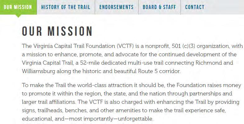

58 Next Steps The Mission of the Virginia Capital Trail Foundation Pg. 58

59 Next Steps The VDOT SMART Portal provides a one-stop shop for information about VDOT funding programs. Visit the Portal at Pg. 59
60 Next Steps TABLE 1: PEDESTRIAN AND BICYCLE FUNDING OPPORTUNITIES (USDOT TRANSIT, HIGHWAY, AND SAFETY FUNDS) Key: $ = Funds may be used for this activity (restrictions may apply). $* = See program-specific notes for restrictions. ~$ = Eligible, but not competitive unless part of a larger project. Pg. 60
61 Next Steps TABLE 1 (CONT.): PEDESTRIAN AND BICYCLE FUNDING OPPORTUNITIES (USDOT TRANSIT, HIGHWAY, AND SAFETY FUNDS) Key: $ = Funds may be used for this activity (restrictions may apply). $* = See program-specific notes for restrictions. ~$ = Eligible, but not competitive unless part of a larger project. Pg. 61
62 Next Steps Pg. 62
63 Next Steps o o o o o o o o o o Pg. 63
64 Next Steps o Pg. 64


65 Appendices FIGURE 12: MAP SEGMENTS KEY Pg. 65
66 Appendices FIGURE 13: CAPITAL TRAIL TO WILLIAMSBURG (SEG. 1) Pg. 66
67 Appendices FIGURE 13: CAPITAL TRAIL TO WILLIAMSBURG (SEG. 1, SAME MAP SHOWN ON PREVIOUS PAGE) Pg. 67

68 Appendices FIGURE 14: WILLIAMSBURG TO YORKTOWN ROAD (SEG. 2) Pg. 68
 Pg.")
69 Appendices FIGURE 15: COLONIAL PARKWAY TO YORKTOWN (SEG. 2A, ALTERNATIVE ROUTE ONLY) Pg. 69
 Pg.")
70 Appendices FIGURE 16: YORKTOWN ROAD TO RICHNECK ROAD (SEG. 3) Pg. 70
71 Appendices FIGURE 16: YORKTOWN ROAD TO RICHNECK ROAD (SEG. 3, SAME MAP SHOWN ON PREVIOUS PAGE) Pg. 71
72 Appendices FIGURE 17: RICHNECK ROAD TO ROUTE 17 (SEG. 4) Pg. 72
 Pg.")
73 Appendices FIGURE 18: ROUTE 17 TO NORTH ARMISTEAD AVENUE (SEG. 5) Pg. 73
 Pg. 74")
74 Appendices FIGURE 19: NORTH ARMISTEAD AVENUE TO FORT MONROE (SEG. 6) Pg. 74
75 Appendices FIGURE 19: NORTH ARMISTEAD AVENUE TO FORT MONROE (SEG. 6, SAME MAP SHOWN ON PREVIOUS PAGE) Pg. 75

76 Appendices FIGURE 20: JAMESTOWN-SCOTLAND FERRY TO MOONLIGHT ROAD (SEG. 7) Pg. 76
77 Appendices FIGURE 20: JAMESTOWN-SCOTLAND FERRY TO MOONLIGHT ROAD (SEG. 7, SAME MAP SHOWN ON PREVIOUS PAGE) Pg. 77
 Pg.")
78 Appendices FIGURE 21: MOONLIGHT ROAD TO SMITHFIELD (SEG. 8) Pg. 78

79 Appendices FIGURE 22: SMITHFIELD TO CHUCKATUCK (SEG. 9) Pg. 79

80 Appendices FIGURE 23: CHUCKATUCK TO SUFFOLK/SOUTH HAMPTON ROADS TRAIL (SEG. 10) Pg. 80
 Pg.")
81 Appendices FIGURE 24: ROUTE 17 TO SOUTH HAMPTON ROADS TRAIL (SEG. 10A, ALTERNATIVE ROUTE ONLY) Pg. 81
82 Appendices Pg. 82
83 Appendices Pg. 83
84 Appendices TABLE 2: PUBLIC COMMENTS AND ASSOCIATED HRTPO RESPONSES Pg. 84
85 Appendices Pg. 85
86 Appendices Pg. 86
87 Appendices Pg. 87
88 Appendices Pg. 88
89 Appendices Pg. 89
90 Appendices Pg. 90
91 Appendices Pg. 91


92 Appendices Constructed segment of the Natchez Trace Multi-Use Trail o o Pg. 92
93 Appendices Pg. 93


94 Appendices Proposed Restroom Locations along the Trail, Alameda County, CA Pg. 94


95 Appendices Map 4, Preferred Alignment. King County, WA. Pg. 95


96 Appendices Bay Trail Vine Trail Study (STA.Gov) Pg. 96
Hampton Roads Pedestrian and Bicycle Advisory Committee
 Hampton Roads Pedestrian and Bicycle Advisory Committee HRTPO Transportation Technical Advisory Committee November 6, 2013 Carl E. Jackson III, AICP Transportation Planning Specialist Hampton Roads District
FY 2016 TRANSPORTATION ALTERNATIVES PROGRAM PROJECT SELECTION
 AGENDA ITEM #8: FY 2016 TRANSPORTATION ALTERNATIVES PROGRAM PROJECT SELECTION The Transportation Alternatives Program (TAP) created by MAP-21 requires that 50% of the program funds received by the state
TRANSPORTATION ALTERNATIVES PROGRAM: SELECTED PROJECTS AND FUNDING ALLOCATIONS
 ITEM #9: TRANSPORTATION ALTERNATIVES PROGRAM: SELECTED PROJECTS AND FUNDING ALLOCATIONS The Transportation Alternatives Program (TAP) created by MAP-21 requires that 50% of the program funds received by
Chapter 5 Future Transportation
 Chapter 5 Future Transportation The Future Land Use Plan identifies the desired land use designations. The land uses desired for Crozet depend, in large part, on the success of the transportation system,
Hampton Roads Pedestrian and Bicycle Advisory Committee
 Hampton Roads Pedestrian and Bicycle Advisory Committee Virginia Bicycle and Pedestrian Advisory Committee April 22, 2015 Carl E. Jackson, AICP Transportation Planning Specialist Hampton Roads District
APPENDIX A: Complete Streets Checklist DRAFT NOVEMBER 2016
 APPENDIX A: Complete Streets Checklist DRAFT NOVEMBER 2016 Complete Streets Checklist MetroPlan Orlando s Complete Streets Checklist is an internal planning tool for staff to further implementation of
5 CIRCULATION AND STREET DESIGN
 5 CIRCULATION AND STREET DESIGN This chapter describes circulation and streetscape improvements proposed for the Northwest Chico Specific Plan Area. It includes detailed design specifications for existing
Lee s Summit Road Improvement Study Public Open House June 7, 2007 Summary of Comment Card Responses
 Lee s Summit Road Improvement Study Public Open House June 7, 2007 Summary of Comment Card Responses Introduction At the Lee s Summit Road Improvement Study Public Open House held Thursday, June 7, 2007
REGIONAL BICYCLE AND PEDESTRIAN DESIGN GUIDELINES
 REGIONAL BICYCLE AND PEDESTRIAN DESIGN GUIDELINES November 16, 2011 Deb Humphreys North Central Texas Council of Governments Bicycle and Pedestrian Advisory Committee Snapshot of the Guide 1. Introduction
Saskatchewan Drive Roadway Rehabilitation and Shared-Use Path Widening
 Saskatchewan Drive Roadway Rehabilitation and Shared-Use Path Widening We are here today to present the draft plan for the Saskatchewan Drive Roadway Rehabilitation and Shared-Use Path Widening project
Montgomery County Life Sciences Center Loop Trail
 Montgomery County Life Sciences Center Loop Trail Advisory Committee Meeting #1 February 10, 2015 Agenda 1. Project Background 2. Existing Conditions Analysis 3. Examples from Elsewhere 4. Discussion Project
Appendix 3 Roadway and Bike/Ped Design Standards
 Appendix 3 Roadway and Bike/Ped Design Standards OTO Transportation Plan 2040 4/20/2017 Page A3-1 Adopted Standards The adopted OTO Design Standards and Major Thoroughfare Plan are contained herein.
Legislative Update Williamsburg Residency
 Hampton Roads District Legislative Update Williamsburg Residency Jim Brewer, Resident Administrator 757-253-5140 Projects Under Way Warwick Boulevard Project http://www.warwickboulevard.org/ Contractors:
Agenda. Overview PRINCE GEORGE S PLAZA METRO AREA PEDESTRIAN PLAN
 PRINCE GEORGE S PLAZA METRO AREA PEDESTRIAN PLAN May 28, 2008 Agenda Welcome and introductions Project overview and issue identification Planning context and strengths Design challenges and initial recommendations
Bicycle and Pedestrian Facilities Toolbox (Excerpt from Figure 3.1)
") Appendix B Neighborhood Connections Summaries This Appendix is a supplement to the information presented in Chapter 3 Connect People. The Appendix includes a summary or profile for each of the proposed
Appendix B Neighborhood Connections Summaries This Appendix is a supplement to the information presented in Chapter 3 Connect People. The Appendix includes a summary or profile for each of the proposed
Broad Street Bicycle Boulevard Design Guidelines
 Broad Street Bicycle Boulevard Design Guidelines Building from the strategies introduced in the 2013 Bicycle Transportation Plan and community input received thus far, City Transportation Staff have identified
East Burke Transportation, Safety and Capacity Improvements
 East Burke Transportation, Safety and Capacity Improvements The purpose of this project is to increase mobility and improve safety for pedestrians, cyclists, and motor vehicles along VT Route 114 in the
Construction Specifications Manual
 Isle of Wight County Pedestrian and Bicycle Master Plan Construction Specifications Manual Adopted August 20, 2009 Introduction The Isle of Wight County Pedestrian and Bicycle Facilities Master Plan was
TRANSPORTATION COMMISSION Agenda Staff Report
 TRANSPORTATION COMMISSION Agenda Staff Report Agenda Item No. 5.a DATE: JULY 31, 2014 TO: FROM: SUBJECT: TRANSPORTATION COMMISSION COMMUNITY DEVELOPMENT DEPARTMENT - PLANNING DRAFT OLYMPIC CORRIDOR PREFERRED
TABLE OF CONTENTS. Executive Summary
 Executive Summary Background... ES-1 Pedestrian Network... ES-2 Bikeway Network... ES-2 Collision History... ES-2 Public Input... ES-4 Conclusions and Recommendations... ES-4 1. Introduction and Setting
Austin Avenue Bridges Project. Public Meeting Summary
 Austin Avenue Bridges Project Public Meeting Summary June 29, 2016 Red Table Safety and Connectivity Notes: 1. Would like to see forensic report evaluations 2. What is the lifespan? 3. Extend safety considerations
2.0 Existing Conditions
 20 2.0 Existing Conditions 2.1 Land Use, Future Growth Patterns, Physical Barriers Geographic Overview Sutter County s land use pattern is characterized by extensive agricultural areas, significant natural
Route 29 Solutions Projects
 Route 29 Solutions Route 29 Solutions Projects www.route29solutions.org October 10, 2014 Route 29 Widening to Six Lanes Albemarle County This project will widen a 1.8-mile segment of Route 29 from four
INDEX. Geometric Design Guide for Canadian Roads INDEX
 Acceleration lane, see Lanes, Acceleration Access, 8.1 Access Management and Functional Classification 8.2 Access Management by Design Classification 8.3 Access Configuration 8.4 Building Set-Back Guidelines
Application to AASHTO to recognize six suggested relocations of U.S. Bicycle Route 1 in the Northern Virginia District.
 September 7 th, 2007 Application to AASHTO to recognize six suggested relocations of U.S. Bicycle Route 1 in the Northern Virginia District. Acting District Administrator Mr. Morteza Salehi has endorsed
WHEREAS delivery trucks also pass through the Narrows, into the northern parking lot, to loading docks in the back of the building.
 CEDAR-ISLES-DEAN NEIGHBORHOOD ASSOCIATION ( CIDNA ) RESOLUTION OPPOSING A DRUG STORE DRIVE THRU, AND COMMENDING DORAN COMPANIES FOR PROPOSING MITIGATING AMENITIES INCLUDING NEW LANDSCAPING AND A DEDICATED
LANCASTER CITY BICYCLE NETWORK
 LANCASTER CITY BICYCLE NETWORK Downtown Merchants Meeting Wednesday, July 19, 2017 http://www.lancasteratp. DOWNTOWN WALKABILITY ANALYSIS What changes can be made, in the least amount of time, and for
Columbia Pike Implementation Team (CPIT) Meeting
 Meeting") Columbia Pike Implementation Team (CPIT) Meeting November 30, 2010 Agenda Introductions / Purpose of Meeting Review of project goals Multimodal project: 10% street design between the curbs Discussion Multimodal
Columbia Pike Implementation Team (CPIT) Meeting November 30, 2010 Agenda Introductions / Purpose of Meeting Review of project goals Multimodal project: 10% street design between the curbs Discussion Multimodal
Chapter 2: Standards for Access, Non-Motorized, and Transit
 Standards for Access, Non-Motorized, and Transit Chapter 2: Standards for Access, Non-Motorized, and Transit The Washtenaw County Access Management Plan was developed based on the analysis of existing
DRAFT - CITY OF MEDFORD TRANSPORTATION SYSTEM PLAN Roadway Cross-Sections
 Roadway Cross-Sections Medford s roadway cross-section standards apply to new and reconstructed roads. The crosssections take into consideration roadway function and operational characteristics, including
Southwest Bus Rapid Transit (SW BRT) Functional Planning Study - Executive Summary January 19 LPT ATTACHMENT 2.
 Functional Planning Study - Executive Summary January 19 LPT ATTACHMENT 2.") Southwest Bus Rapid Transit (SW BRT) Functional Planning Study - Executive Summary 2011 January 19 1 of 19 Introduction This executive summary presents the results of the Southwest Bus Rapid Transit (SW
Southwest Bus Rapid Transit (SW BRT) Functional Planning Study - Executive Summary 2011 January 19 1 of 19 Introduction This executive summary presents the results of the Southwest Bus Rapid Transit (SW
City of Wilsonville 5 th Street to Kinsman Road Extension Project
 City of Wilsonville 5 th Street to Kinsman Road Walking Tour & Neighborhood Workshop Summary Report Public Outreach Overview On July 18 th, 2017, the City of Wilsonville hosted a neighborhood walking tour
US Bicycle Route 1 Summary Report: Selection of Preferred Route
 US Bicycle Route 1 Summary Report: Selection of Preferred Route Background US Bicycle Route 1 (USBR 1) in Virginia was designated by the American Association of State Highway and Transportation Officials
CHAPTER TWO: EXISTING CONDITIONS
 CHAPTER TWO: EXISTING CONDITIONS Overview Multiple environmental, physical, and social features impact the quality and quantity of active transportation facilities in the Hamptons Roads region. The existence
Transportation Corridor Studies: Summary of Recommendations
 Transportation Corridor Studies: Summary of Recommendations Route 4 Corridor Study: Route 10 Corridor Study: Route 44 Corridor Study: Route 175 Corridor Study: Route 5/15 Corridor Study: Rentschler Field
BETHEL ROAD AND SEDGWICK ROAD CORRIDOR STUDY
 DRAFT PLAN City Council Meeting August 14, 2017 STUDY AREA Sedgwick Corridor State Route 160, principal arterial with Class 3 access management designation, commuter and freight route, connection to SR
4. ENVIRONMENTAL IMPACT ANALYSIS 9. TRANSPORTATION AND TRAFFIC
 4. ENVIRONMENTAL IMPACT ANALYSIS 9. TRANSPORTATION AND TRAFFIC 4.9.1 INTRODUCTION The following section addresses the Proposed Project s impact on transportation and traffic based on the Traffic Study
City of Sammamish. Welcome. Issaquah-Fall City Road Improvements Project Phase I Design: 242nd Avenue SE to Klahanie Drive SE
 Welcome Welcome to the third community meeting for the Issaquah-Fall City Road Improvements Project. AGENDA 6:00 p.m. Welcome and sign-in 6:10 p.m. Presentation 6:50 p.m. Open house Learn about the roadway
PRINCE GEORGE S PLAZA METRO AREA PEDESTRIAN PLAN
 PRINCE GEORGE S PLAZA METRO AREA PEDESTRIAN PLAN May 28, 2008 Agenda Welcome and introductions Project overview and issue identification Planning context and strengths Design challenges and initial recommendations
Make Lincoln Highway an economically vibrant corridor that is safe, efficient, and beautiful for local residents and visitors.
 Lincoln Highway Streetscape Plan Stakeholder Workshop #2 Handout Contents Introduction and Project Vision Planning Principles Specific Recommendations including a Proposed Typical Roadway Section Renderings
Executive Summary Route 30 Corridor Master Plan
 Route Corridor Master Plan Project Overview The Route Corridor Master Plan is a coordinated multimodal transportation and land use plan for the entire stretch of Route through East Whiteland Township,
NJDOT Complete Streets Checklist
 Background The New Jersey Department of Transportation s Complete Streets Policy promotes a comprehensive, integrated, connected multi-modal network by providing connections to bicycling and walking trip
Appendix T CCMP TRAIL TRAFFIC & TRANSPORTATION DESIGN STANDARD
 Appendix T CCMP 3.3.4 TRAIL TRAFFIC & TRANSPORTATION DESIGN STANDARD 3.3.4 Trail Traffic and Transportation Design Multi-use trails have certain design standards, which vary depending on the agency that
Chapter 3 DESIGN SPECIFICATIONS
 Brampton PathWays Planning and Design Guidelines 27 Chapter 3 DESIGN SPECIFICATIONS 3.1 CLASS 1 MULTI-USE PATH Off-road multi-use trails are the backbone of the Brampton PathWays Network. They are typically
PEDESTRIAN ACCOMMODATIONS DPS 201 AT INTERCHANGES
 PEDESTRIAN ACCOMMODATIONS DPS 201 AT INTERCHANGES UNDERSTANDING THE ISSUES Intersections of freeway ramp terminals at crossroads are the most critical components of an interchange Challenge: balance mobility
MAG Town of Cave Creek Bike Study Task 6 Executive Summary and Regional Significance Report
 Page 1 MAG Town of Cave Creek Bike Study Task 6 Executive Summary and Regional Significance Report August 1, 2012 MAG Project #481 Page 2 Task 6 Executive Summary and Regional Significance Report Introduction
Cycle Track Design Best Practices Cycle Track Sections
 Design Best Practices Sections It is along street segments where the separation and protection methods of cycle tracks offer more comfort than conventional bicycle lanes, and are more attractive to a wide
Lake to Lake LAKE YORK. CYCLING ROUTE and WALKING TRAIL FEASIBILITY and DESIGN STUDY LAKE. CITY of REGION ONTARIO SIMCOE TORONTO
 LAKE SIMCOE Lake to Lake CYCLING ROUTE and WALKING TRAIL FEASIBILITY and DESIGN STUDY YORK REGION Overview Report JUNE 2013 CITY of TORONTO LAKE ONTARIO Table of Contents Study background 2 Study Background............................
US 41 COMPLETE STREETS CORRIDOR PLANNING STUDY from University Parkway to Whitfield Avenue
 41 US 41 COMPLETE STREETS CORRIDOR PLANNING STUDY from University Parkway to Whitfield Avenue EXECUTIVE SUMMARY DRAFT FEBRUARY 2019 Project Overview The US 41 Complete Streets Corridor Planning Study,
Guidance. ATTACHMENT F: Draft Additional Pages for Bicycle Facility Design Toolkit Separated Bike Lanes: Two-Way to One-Way Transitions
 ATTACHMENT F: Draft Additional Pages for Bicycle Facility Design Toolkit Separated Bike Lanes: Two-Way to One-Way Transitions This treatment provides a transition from two-way separated bike lanes to one-way
Project Description Form 8EE
 Project Description Form 8EE Basic Project Information Submitting Jurisdiction/Agency: Town of Dumfries Project Title: Route 1 (Fraley Blvd) Widening: Brady's Hill Road to Dumfries Road Project Location:
Project Overview. Rolling Road Widening Fairfax County. Get Involved. Design Public Hearing. Contact Information
 Get Involved VDOT representatives will review and evaluate information received as a result of this meeting. Please fill out the comment sheet provided in this brochure if you have any comments or questions.
Houma-Thibodaux Metropolitan Planning Organization STP<200K Funding Application APPLICATION
 APPLICATION HOUMA-THIBODAUX METROPOLITAN PLANNING ORGANIZATION (HTMPO) FOR SURFACE TRANSPORTATION PROGRAM (STP
Lynchburg District Update
 Lynchburg District Update Virginia Statewide Bicycle and Pedestrian Advisory Committee Spring Meeting May 16 th, 2017 David Cook Transportation Planner, VDOT Lynchburg District Table of Contents Active
Bicycle Pedestrian Master Plan Pre Bid Meeting Portsmouth, NH August 15, 2013
 Bicycle Pedestrian Master Plan Pre Bid Meeting Portsmouth, NH August 15, 2013 2005 Master Plan GOAL: Provide for safe and convenient bicycle and pedestrian circulation throughout the City. Develop a city
Transportation Planning Division
 Transportation Planning Division Presentation Outline Study Tasks Recap of Previous Meetings Data Collected Focus Areas within Study Limits Design Principles Tool Box Recommended Concepts Schedule Moving
COWETA HIGH SCHOOL AND EAST HIGHWAY 51
 COWETA HIGH SCHOOL AND EAST HIGHWAY 51 Lack of sidewalks along Ben Lumpkin Rd. Lack of crosswalks and ramps at intersection. Hwy 51 is wide to cross as a pedestrian. No ADA compliance or connection to
DRAFT. System Components. Greenway Trails. Introduction. Trail Types. Zebulon Greenway Master Plan
 5 System Components Wakefield Street Photo Simulation showing Sharrows Introduction The Master Plan identifies various system components that, together, create a comprehensive greenway system. These components
TOWN OF WILLIAMSTON, SC BICYCLE AND PEDESTRIAN MASTER PLAN TOWN OF WILLIAMSTON, SC BICYCLE AND PEDESTRIAN MASTER PLAN
 TOWN OF WILLIAMSTON, SC BICYCLE AND PEDESTRIAN MASTER PLAN Americans Want Choices 55% of Americans would rather drive less & walk more. Transit use is growing faster than population or highway travel.
Duwamish Way-finding and CTR Report
 V. North Tukwila When the North Tukwila Manufacturing and Industrial Center was designated in 1992 as part of the region s land use and transportation plan, the plan called for the area to set a light-rail
Tonight is for you. Learn everything you can. Share all your ideas.
 Strathcona Neighbourhood Renewal Draft Concept Design Tonight is for you. Learn everything you can. Share all your ideas. What is Neighbourhood Renewal? Creating a design with you for your neighbourhood.
Comments EXECUTIVE SUMMARY
 Comments 1. Under any Alternatives, MCDOT should provide better at-grade pedestrian crossing of Georgia Avenue and Forest Glen Road, including improved crosswalks with wider medians and adequate signal
FM 1092/Murphy Road Access Management Study Pulic Meeting #1. Wednesday, August 31, :00 p.m. 8:00 p.m.
 FM 1092/Murphy Road Access Management Study Pulic Meeting #1 Wednesday, August 31, 2011 6:00 p.m. 8:00 p.m. Introductions Agency Partners H-GAC Missouri City TxDOT Introductions Consulting Team In Association
West Dimond Blvd Upgrade Jodhpur Street to Sand Lake Road
 West Dimond Blvd Jodhpur St to Sand Lake CSS Transportation Project Summary Municipality of Anchorage Project # 05 005 Project Manager: John Smith, P.E. (MOA PM&E) Project Administrator: Julie Makela,
Corpus Christi Metropolitan Transportation Plan Fiscal Year Introduction:
 Introduction: The Safe, Accountable, Flexible, Efficient Transportation Equity Act: A Legacy for Users (SAFETEA-LU) has continued the efforts started through the Intermodal Surface Transportation Efficiency
Development of Arlington County s Marked Crosswalk Guidelines. Jon Lawler, P.E. Design Engineer Arlington County, VA
 Development of Arlington County s Marked Crosswalk Guidelines Jon Lawler, P.E. Design Engineer Arlington County, VA April 13, 2015 Transportation System Users Residents Estimated 215,000 in 2014 Lowest
This Chapter sets forth the minimum design, technical criteria and specifications to be used in the preparation of all roadway plans.
 4.1 GENERAL This Chapter sets forth the minimum design, technical criteria and specifications to be used in the preparation of all roadway plans. These Roadway Standards are for new construction and modification
INNER LOOP EAST. AIA Rochester Annual Meeting November 13, 2013 TRANSFORMATION PROJECT. Bret Garwood, NBD Erik Frisch, DES
 INNER LOOP EAST TRANSFORMATION PROJECT AIA Rochester Annual Meeting November 13, 2013 Bret Garwood, NBD Erik Frisch, DES Why? We are building a city that encourages walking, biking and enjoying the outdoor
APPENDIX 2 LAKESHORE ROAD TRANSPORTATION REVIEW STUDY EXECUTIVE SUMMARY
 APPENDIX 2 LAKESHORE ROAD TRANSPORTATION REVIEW STUDY EXECUTIVE SUMMARY Appendix 2 City of Mississauga Lakeshore Road FINAL REPORT Transportation Review Study December 2010 EXECUTIVE SUMMARY Study Purpose
Sandwich Pedestrian/Bicycle Planning
 Sandwich Pedestrian/Bicycle Planning Improved Pedestrian and Bicycle Connections with the Cape Cod Canal Multi-use Path February 2014 Table of Contents Introduction... 1 Background... 1 Study Goals...
Watertown Complete Streets Prioritization Plan. Public Meeting #1 December 14, 2017
 Watertown Complete Streets Prioritization Plan Public Meeting #1 December 14, 2017 Goals for Public Meeting Overview of MassDOT Complete Streets Funding Program Educate the community on Complete Streets
TRAFFIC CALMING GUIDE FOR TORONTO CITY OF TORONTO TRANSPORTATION SERVICES DIVISION
 TRAFFIC CALMING GUIDE FOR TORONTO CITY OF TORONTO TRANSPORTATION SERVICES DIVISION CITY OF TORONTO TRANSPORTATION SERVICES DIVISION 2016 TRAFFIC CALMING GUIDE FOR TORONTO TABLE OF CONTENTS Introduction
TABLE OF CONTENTS 7.0 THOROUGHFARE PLAN. Analysis of Future Conditions Thoroughfare Plan Proposed Cross-Sections.. 7.
 TABLE OF CONTENTS 7.0 THOROUGHFARE PLAN Analysis of Future Conditions.. 7.2 Thoroughfare Plan.. 7.3 Proposed Cross-Sections.. 7.4 Arterials Minor Arterials Collectors Local Streets Thoroughfare Plan Map
UPTOWN REGIONAL BIKE CORRIDORS PROJECT SAN DIEGO ASSOCIATION OF GOVERNMENTS
 UPTOWN REGIONAL BIKE CORRIDORS PROJECT SAN DIEGO ASSOCIATION OF GOVERNMENTS SUMMARY REPORT: COMMUNITY UPDATE MEETING February 6, 2014 6 8:30 p.m. Roosevelt Middle School Library 3366 Park Blvd, San Diego
Scarlett Road Bridge & Road Improvements Lambton Park Community School - Gymnasium Tuesday November 28 th, 2017
 Scarlett Road Bridge & Road Improvements Lambton Park Community School - Gymnasium Tuesday November 28 th, 2017 PROJECT LOCATION 2 SCARLETT ROAD BRIDGE Constructed in 1912, the bridge carries 4 active
Appendix C. Bicycle Route Signage
 Appendix C Bicycle Route Signage This page intentionally left blank. APPENDIX C - BICYCLE ROUTE AND WAYFINDING SIGNAGE Bicycle route signs are wayfinding signs that guide bicyclists along preferred, designated
Welcome to the Sellwood Bridge Project Open House!
 Welcome to the Sellwood Bridge Project Open House! 5:30 7:30 pm Please sign in here Information stations and project staff are located throughout the room. Goals for Tonight s Meeting: Learn how the Preferred
3.9 Recreational Trails and Natural Areas
 3.9 Recreational Trails and Natural Areas 3.9.1 Introduction Parks and other recreational facilities such as trails, bicycle routes, and open space are important community resources. This section discusses
PROPOSED BICYCLE AND PEDESTRIAN FACILITY Vicinity of Route 123/I-495 Interchange Tysons, Fairfax County, Virginia
 PROPOSED BICYCLE AND PEDESTRIAN FACILITY Vicinity of Route 123/I-495 Interchange Tysons, Fairfax County, Virginia PRELIMINARY ENGINEERING REPORT Prepared for: Prepared by: July 2017 Table of Contents 1
What Is a Complete Street?
 Session 5 Charleen Zimmer, AICP, Zan Associates May 5-7, 2010 What Is a Complete Street? May 2010 5-1 Not a Complete Street More of a Complete Street May 2010 5-2 Benefits of Complete Streets Safety for
Public Information Meeting. Orange Camp Road. Dr. Martin Luther King Jr. Beltway to I-4. Presented by: Volusia County August 2, 2018
 Public Information Meeting Orange Camp Road Dr. Martin Luther King Jr. Beltway to I-4 Presented by: Volusia County August 2, 2018 1 Project Goals To improve the operations and safety for Orange Camp Road
ARLINGTON COUNTY, VIRGINIA
 ARLINGTON COUNTY, VIRGINIA County Board Agenda Item Meeting of October 15, 2016 DATE: October 7, 2016 SUBJECT: Adoption of amendments to the Master Transportation Plan (MTP) to create a new Pedestrian
Multi-Modal Traffic Analysis. Parisi and Associates
 Mill Valley to Corte Madera Bicycle and Pedestrian Corridor Study Appendix D: Multi-Modal Traffic Analysis Prepared by Parisi and Associates August 2009 Appendix D - Multi-Modal Traffic Analysis Table
2014/2015 BIKE ROUTE PLAN 83 AVENUE PROTECTED BIKE LANE
 About the Project The City of Edmonton is planning a major bike route on the southside of Edmonton. The Strathcona Bike Route will connect the communities of Strathcona, Garneau and the University area,
Environmental Assessment Findings & Recommendations. Public Hearing November 13, 2014
 Environmental Assessment Findings & Recommendations Public Hearing November 13, 2014 Welcome! Welcome and Introductions Project and Environmental Assessment Overview Public Comments Adjourn Purpose of
Bike San Mateo County San Mateo County Bicycle Plan Recommendations August 30, 2010
 Policy and Procedures Develop and Implement a Complete Streets Policy to comply with DD-64-R1 and AB1358 Commencing January 1, 2011, AB1358 requires that the legislative body of a city or county, upon
Omaha s Complete Streets Policy
 Omaha s Complete Streets Policy (Adopted August 2015) VISION To create great places and enhance our quality of life, the City of Omaha will provide safe, accessible streets for all users. Complete Streets
Perryville TOD and Greenway Plan
 Perryville TOD and Greenway Plan Greenway Glossary Pathway: A bicycle and pedestrian path separated from motorized vehicular traffic by an open space, barrier or curb. Multi-use paths may be within the
Route 79/Davol Street Corridor Study
 Route 79/Davol Street Corridor Study Fall River, MA Public Information Meeting #2 November 21, 2013 Fall River Heritage State Park Fall River, MA Agenda Welcome and Introductions Overview of Study Process
Proposed Bridge Street East Bicycle Lanes Public Open House Thursday, April 27, 2017
 WELCOME Proposed Bridge Street East Bicycle Lanes Public Open House Thursday, April 27, 2017 Purpose of the Open House The purpose of this Open House is to gain public input on the bicycle lanes proposed
Pennsylvania Avenue (CR 484) Design Alternatives Study
 Design Alternatives Study") MEMORANDUM Pennsylvania Avenue (CR 484) Design Alternatives Study Prepared for: APRIL 2016 Prepared By TABLE OF CONTENTS Project Background... 2 Previous Concept... 2 Existing Conditions... 4 New Alternatives...
MEMORANDUM Pennsylvania Avenue (CR 484) Design Alternatives Study Prepared for: APRIL 2016 Prepared By TABLE OF CONTENTS Project Background... 2 Previous Concept... 2 Existing Conditions... 4 New Alternatives...
Complete Streets Policy DAVID CRONIN, P.E., CITY ENGINEER
 Complete Streets Policy DAVID CRONIN, P.E., CITY ENGINEER Complete Streets City Commission adopted a Complete Streets policy in 2012 Complete Streets are road networks that are designed for all users:
This page intentionally left blank.
 This page intentionally left blank. COMMUNITY Coweta Community Overview Coweta Coweta, a residential community located in Wagoner County, is a suburb of Tulsa situated southeast of the metropolitan area
ROUTE 81 CORRIDOR STUDY DESIGN CONCEPTS
 RT 81 Corridor Study CLINTON ROUTE 81 CORRIDOR STUDY DESIGN CONCEPTS View north on High Street, with potential improvements to the streetscape Draft Recommendations November 8 th, 2018 TOWN OF CLINTON
Multimodal Through Corridors and Placemaking Corridors
 68 Multimodal Through Corridors and Placemaking Corridors Corridors have different functions in a region. Some corridors are used to get smoothly and rapidly through a region or to get quickly to major
Circulation in Elk Grove includes: Motor vehicles, including cars and trucks
 Circulation, as it is used in this General Plan, refers to the many ways people and goods move from place to place in Elk Grove and the region. Circulation in Elk Grove includes: Motor vehicles, including
TOWN OF IRONDEQUOIT ACTIVE TRANSPORTATION PLAN
 TOWN OF IRONDEQUOIT March 2017 FINAL DRAFT: EXECUTIVE SUMMARY PREPARED FOR SUBMITTED BY IN ASSOCIATION WITH Town of Barton & Loguidice, DPC Sprinkle Consulting, Inc. 1280 Titus Avenue Rochester, New York
WYDOT DESIGN GUIDES. Guide for. NHS Arterial (Non-Interstate)
") WYDOT DESIGN GUIDES Guide for NHS Arterial (Non-Interstate) 2014 GUIDE FOR NATIONAL HIGHWAY SYSTEM (NHS) HIGHWAYS (NHS ARTERIALS, Non-Interstate) PRESERVATION REHABILITATION RECONSTRUCTION INTRODUCTION
WYDOT DESIGN GUIDES Guide for NHS Arterial (Non-Interstate) 2014 GUIDE FOR NATIONAL HIGHWAY SYSTEM (NHS) HIGHWAYS (NHS ARTERIALS, Non-Interstate) PRESERVATION REHABILITATION RECONSTRUCTION INTRODUCTION
Active Transportation Facility Glossary
 Active Transportation Facility Glossary This document defines different active transportation facilities and suggests appropriate corridor types. Click on a facility type to jump to its definition. Bike
Phone: Fax: Project Reference No. (to be filled out by MassHighway):
:") Massachusetts Highway Department District 3 Project Need Form (PNF) This form is intended to provide preliminary information about the proposed project. It is not expected that all information that is
Massachusetts Highway Department District 3 Project Need Form (PNF) This form is intended to provide preliminary information about the proposed project. It is not expected that all information that is