INSERT: Chapter 1 Title Page
|
|
|
- Kelly Edward Collins
- 5 years ago
- Views:
Transcription

1
2 INSERT: Chapter 1 Title Page 1


3
4
5
6
7
8 INSERT: Chapter 1 Title Page 1


9
10 EXECUTIVE SUMMARY The Delaware Valley Regional Planning Commission (DVRPC) continually programs transportation corridor studies that strive to identify and address problems that impede the efficient and equitable movement of goods and people in the Delaware Valley. The NJ 70 corridor, originally identified in Direction 2020 DVRPC s long range transportation plan, is the subject of this study. This report focuses on 8.33 miles of NJ 70 between the Airport Circle in Pennsauken, Camden County, and the Marlton Circle in Evesham Township, Burlington County. Cherry Hill Township accounts for the majority of the study area. In addition to Pennsauken, Evesham, and Cherry Hill, Haddonfield Borough was included in the study area due to its proximity to Cherry Hill and the influence of NJ 70 on the borough s local traffic. A task force comprised of municipal representatives and New Jersey state transportation officials was formed to guide the activities of the study. This study effort was unique because it was conducted concurrent with the New Jersey Department of Transportation s Route 70 Concept Development Study. DVRPC and NJDOT worked closely, shared resources, and collaborated on the public outreach component. Although the study area was the same, the approach of each study was different as were the finished products. This is discussed further in section 1.1. At approximately 60 miles in length, NJ 70 provides a direct connection between the Delaware River (via US 30) and the New Jersey coastline of Ocean County. Throughout its history Route 70 has been used as a city to shore route. Over time the 8.33 miles of NJ 70 that is the focus of this study has seen significant development. The population of Cherry Hill Township, the second largest in Camden County, has grown and subsequently expanded into nearly all available land in the municipality. NJ 70 is the retail and commercial center of the township, providing its economic base. As a result, the NJ 70 corridor generates a significant number of shopping and work trips both local and regional. In addition, the corridor experiences seasonal volume spikes due to shore traffic. Through meetings with the study task force, data analysis, and field visits, transportation problem locations were identified within the corridor study area. This report focuses on 15 site-specific problem locations and includes a discussion of corridor-wide problems, i.e. deficiencies that are common throughout the study area. Other problem types discussed include cut-through traffic, deficiencies in signs and lane markings, and mobility issues. ii
11 NJ 70 is plagued by three major corridor-wide problems that became recurring themes during the study effort: congestion, access, and accidents. Recurring peak period congestion has reduced traffic flow to stop and go conditions in several sections of the study area. This is common knowledge to regular users of the facility, and was quantified in NJDOT s Route 70 Concept Development Report. NJ 70 is divided by a grass median that limits access opportunities to either signalized intersections or unsignalized median openings, where available. Extra distance and time is added to almost every trip as drivers are forced to turn around via the nearest intersection in order to access the opposite direction of NJ 70. As a result, signalized intersections experience higher demand causing them to be overburdened. Congestion, combined with limited access, also results in cut through traffic the use of neighborhood streets as short cuts to by-pass traffic congestion from long waits at signals on NJ 70. Accidents on NJ 70 are largely the byproduct of congestion and access related problems. Rear-end crashes are common on congested facilities, especially where travel lanes transition from 3 to 2 as motorists arrive abruptly on the heels of slower moving traffic. Crash clusters were analyzed using data. Twenty-two locations were identified where twenty-four or more crashes occurred along a one-tenth mile stretch during the three-year period. Possible contributing factors and potential counter measures were discussed in the body of the report for the five highest crash cluster locations. These three problems, congestion, access, and accidents, are most common in the parts of the corridor that have the highest demand due to retail concentrations and/or are proximate to major roadway connections, i.e.: I-295. This report discusses the issues facing the corridor and presents potential improvement scenarios for each. The findings of this study suggest that no simple, easy, solution is readily available to cure the ills of NJ 70. Nor are these ills solely transportation related. Rather, they are symptoms of the development pattern advanced throughout the corridor over time, exacerbated by a steady rise in automobile ownership. In order to best address current needs and plan for the future, the municipalities of the study area, namely Cherry Hill, must decide what NJ 70 is to become. Addressing only one of the three major transportation issues affecting NJ 70, i.e. congestion only, may have impacts on other aspects of life for corridor residents and for those who depend on the facility. iii
12 INSERT: Chapter 1 Title Page 1
13
14 1. INTRODUCTION NJ 70 was identified as one of the many essential routes for moving people and goods in Direction 2020, the Delaware Valley Regional Planning Commission s (DVRPC) regional long-range, comprehensive land use and transportation plan. The long-range plan laid the groundwork for a more detailed evaluation of each identified corridor. This report takes a comprehensive look at NJ 70. The purpose of the corridor study is to identify site specific and corridor-wide transportation issues, determine what the contributing factors are, and identify potential improvements. The study area includes 8.33 miles of NJ 70 facility between the Airport Circle to the west and the Marlton Circle to the east, traversing Pennsauken, Cherry Hill and Evesham Townships. Haddonfield Borough was also considered part of the study area due to the presence of feeder routes that carry traffic from and through the borough to the NJ 70 corridor. Cherry Hill Township, which accounts for the largest part of the study corridor, is an older, densely developed suburban location comprised mostly of singlefamily detached homes all with access to NJ 70. The frontage of NJ 70 is a mix of retail and professional offices. Industrial developments are located along other select corridors that connect with NJ 70. Throughout the corridor there is very little undeveloped land; new developments come about through infill. One example is the Garden State Park redevelopment project that is currently underway. All study area municipalities have good highway access with NJ 70 being their main east-west facility. To guide the study effort, DVRPC collaborated with a task force comprised of municipal and state representatives. The problem locations and corridor-wide issues identified through meetings with the task force formed the basis for the analysis. The major concerns of the task force include congestion, crash frequency, and access. DVRPC s effort is intended to dovetail with the New Jersey Department of Transportation s Concept Development Study of NJ 70, which was conducted concurrently. The NJDOT study is a technical analysis based on current and future traffic count data. DVRPC s corridor study takes a planning approach that considers transportation problems in the context of the existing land uses and infrastructure. Identified improvements, derived from quantitative and qualitative data and analysis, seek to balance mobility and quality of life issues in a context sensitive manner. A comparison of the two studies is summarized in section 1.1. To guide the study effort, DVRPC collaborated with a task force comprised of municipal and state representatives. 2
15 The report is divided into eight chapters plus executive summary and appendices. Chapter two, Study Area Description, contains an analysis of demographic characteristics, travel patterns, environmental justice issues, and environmental sensitivities. Chapter three describes the transportation system in terms of vehicle, bus, rail, pedestrian, and bicycle movements. Chapter four focuses on safety through an analysis of crash data. Chapter five, entitled Transportation Issues, is divided into five subchapters that focus on corridor-wide and location specific transportation problems. The identified issues were culled from municipal interviews, field visits, and through collaborations with coordinating agencies. Improvement scenarios are provided for all identified problems. Chapters six and seven provide an analysis of intelligent transportation systems and the congestion management. The report culminates in chapter eight with a matrix of the recommended improvements and a discussion of overall conclusions. The matrix can be used as a punch list by local and state officials for advancing these concepts to the project stage. 3
16 1.1 COORDINATION WITH NEW JERSEY DEPARTMENT OF TRANSPORTATION In July 2003 the Delaware Valley Regional Planning Commission and the New Jersey Department of Transportation began independent studies of NJ 70. To better coordinate efforts, the two agencies collaborated and shared resources including traffic volumes, transit data, and pedestrian amenities data. All meetings with municipal stakeholders and with the public utilized a single presentation combining elements of each study. In addition, DVRPC provided the Environmental Justice and Environmental Screening components required as part of NJDOT s concept development process. NJDOT also utilized DVRPC s regional model in developing the growth rate and future design year traffic numbers. The final products of each effort are different and intended to compliment one another. NJDOT s report, published in October of 2004, identified short-term breakout projects to be advanced. The following comparison highlights the elements of each study. NJDOT: NJ 70 Concept Development Study One-year effort conducted during fiscal year Study limits: Airport Circle to Marlton Circle (8.33 miles). Engineering analysis of NJ 70 utilizing level of service and future year traffic volumes. Predominant issues identified include congestion, failing level of service at signalized intersections, and crashes. DVRPC: NJ 70 Corridor Study Two-year effort conducted during fiscal years 2004 and Study limits: Airport Circle to Marlton Circle (8.33 miles). Planning analysis of the transportation and land use issues of NJ 70. Predominant issues identified include access deficiencies, crashes, land use and transportation incompatibility, and congestion. 4

17 1.2 RECENT HISTORY OF ROADWAY IMPROVEMENTS ON NJ 70 Recent History In 1986 the New Jersey Department of Transportation (NJDOT) finished a Feasibility Assessment (FA) of the NJ 70 corridor between NJ 38 and NJ 73. The purpose of the study was to evaluate the existing and future transportation problems of the facility, and to develop and assess various design schemes for improving the corridor on an operational, engineering, and cost-effectiveness basis. One buildalternative with eight schemes plus the no-build alternative were considered to alleviate this project s present and future traffic problems. and inefficient for accommodating its associated traffic demands. The text continues, the original intent of this roadway (NJ 70) was to provide a high-speed arterial route connecting the suburban areas of Camden and Burlington Counties to the urban Camden-Philadelphia metropolitan area. However, increased development along this route has caused a reduction in traffic speeds. According to the EA The no-build alternative was rejected because it did not fulfill the goals and objectives of the proposed project. The report states that with no changes to DVRPC 1980: Aerial View of Race Track Circle In 1991 the Federal Highway Administration and the New Jersey Department of Transportation completed an Environmental Assessment (EA) for four intermittent sections of NJ 70 that were recommended for reconstruction as part of NJDOT s comprehensive plan to improve the facility. These four sections were known as Alternative H, the preferred alternative. This work was the next step needed to advance the recommendations of the1986 Feasibility Assessment. The objective of this EA was to identify and evaluate any potential social, economic, or environmental impacts associated with the proposed action. According to the Project Need section of the EA, the conditions on NJ 70 at the time were described as inadequate 5

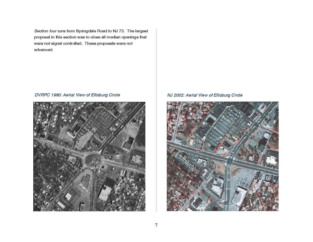
18 the capacity of NJ 70, the expected increases in traffic growth would cause levels of service for the roadway to decrease to breakdown conditions. Proposed and Completed Improvements to NJ 70 Improvements to the four intermittent sections of NJ 70 were to be preceded by the elimination of the Race Track Circle and Ellisburg Circle, and by improvements to NJ 70 between I- 295 and Springdale Road. As of the completion date of this report (10/05) only these three projects were undertaken and completed. The improvements proposed for the four NJ 2002: Aerial View of Race Track Circle intermittent sections, described below, were never realized. Section one includes NJ 70 from the NJ 38 junction to what was formerly know as the Race Track Circle, presently known as the intersection of NJ 70 and Haddonfield Road. Completed improvements include the creation of an eastbound left turn/u-turn near side jug handle utilizing Penn Avenue and Park Boulevard to tie in with Grove Street and the circle elimination improvements. Section two covered from the Race Track Circle project to the Ellisburg Circle project. The major proposals for this section included closing all median openings except at the fire station and at the signalized intersection of Georgia and Edison Avenues. Other improvements to accommodate left and u- turn movements as part of the median closures were also proposed. These projects were not advanced due to a legal confrontation between local residents and the New Jersey Department of Transportation and the Federal Highway Administration. Section three covers NJ 70 from the Ellisburg Circle to I-295. The major proposals for this section included closing all median openings except for two existing signalized intersections, and a westbound left turn slot for access to a large shopping center (Barclay Shopping Center). These proposals were not advanced due to a legal confrontation between local residents and the New Jersey Department of Transportation and the Federal Highway Administration. 6
19
20 INSERT: Chapter 1 Title Page 1
21
22 2.1 REGIONAL SETTING DVRPC s nine county region NJ 70 is a primary arterial facility located in the New Jersey portion of DVRPC s region. Traversing Camden, Burlington, and Ocean Counties, this roadway is oriented radially to the region s core providing a direct connection between Camden City and the New Jersey shore. The study area is 8.33 miles long and covers NJ 70 from NJ 38 in the west to NJ 73 in the east, essentially from the Airport Circle to the Marlton Circle. The study area municipalities are Cherry Hill Township, Evesham Township, Haddonfield Borough, and Pennsauken Township. The corridor study area is depicted in Figure 1. Cherry Hill Township accounts for a wide majority of the frontage along NJ 70, approximately seven linear miles. Throughout Cherry Hill and Evesham Township land uses along NJ 70 are a mix of retail, professional office, and a few institutional uses, some located in strip malls or in stand-alone fashion. Most of the residences along NJ 70 have been converted to professional offices; only a few remain as homes. In the land areas behind the commercial frontage along the facility is a dense network of residential developments. This is where a large portion of the local traffic on NJ 70 is generated. DVRPC

23
24 2.2 DEMOGRAPHICS Camden County was the second slowest growing county in the Delaware Valley Region between 1990 and Analysis of the demographic data contained in Table 1 shows that conditions within most of the study area were consistent with or lagged behind the county s growth. Evesham, located on the east end of the study corridor in Burlington County, was an exception to the trend. Between 1990 and 2000, Camden County experienced a population growth of one percent, about the same rate of growth that Cherry Hill, Haddonfield, and Pennsauken experienced. Employed residents within the county have decreased from about 240,100 to about 235,800, a drop of two percent. In Cherry Hill, Haddonfield, and Pennsauken, employed residents also fell between two and six percent. The drop in employment was even more significant. Throughout the county, a five percent drop in employment took place between 1990 and In the study corridor, the drop in employment ranged from about five percent (Haddonfield and Cherry Hill) to 22 percent (Pennsauken). As noted, the experience of Evesham contrasted with that of the rest of the study corridor. Between 1990 and 2000, the population grew 20 percent. In addition, the number of employed residents increased by 12 percent and employment increased by 33 percent. Evesham outpaced Burlington County, which experienced moderate rates of growth in all of these categories. TABLE 1 STUDY AREA DEMOGRAPHIC CHARACTERISTICS: 1990 AND 2000 Population Employed Residents Employment Municipality Area (mi 2 ) Percent Change Percent Change Cherry Hill Township ,348 69, % 35,965 34, % 50,709 48, % Evesham Township ,309 42, % 20,329 22, % 16,189 21, % Haddonfield Borough ,628 11, % 5,828 5, % 6,380 6, % Pennsauken Township ,738 35, % 16,935 15, % 29,529 23, % Camden County , , % 240, , % 227, , % Burlington County , , % 212, , % 195, , % Source: 1990 Census, DVRPC 2000 and 2025 Municipal Population Estimates (based on 2000 Census), and DVRPC Preliminary 2000 and 2025 Municipal Employment Estimates (based on 2000 Census) Autos / Household Percent Change
25 2.3 LAND USE Figure 2 illustrates land use conditions in the corridor in Residential neighborhoods, in which single-family dwellings predominate, occupy much of the study area. Most commercial development lies adjacent to Route 70 or to perpendicular facilities including Kings Highway, Old Cuthbert Road, and Springdale Road. There is almost no undeveloped land in the study area. Most of the vacant or wooded land is located along the I-295 and New Jersey Turnpike right-of-way, or along the North Branch of the Cooper River. The last developable parcel of land was the Garden State Park property, but construction is under way to convert it to a mixed-use (residential and retail) center. By stripping away the lower intensity uses from the existing land use map, concentrated nodes of commercial, industrial, and higher density residential use are revealed. Figure 3 executes this and displays the activity or development centers in and around the study area. Table 2 lists a sampling of major employers in the study area. The following list is a list of major development centers located within, and immediately adjacent to, the study area: STUDY AREA DEVELOPMENT CENTERS Access Via NJ 70: Airport Industrial Park, Pennsauken Cherry Hill Executive Campus, Cherry Hill Garden State Pavilions, Cherry Hill Garden State Park, Cherry Hill Ellisburg Circle Shopping Center, Cherry Hill Barclay Shopping Center, Cherry Hill Access Via Springdale Road: Cherry Hill Industrial Park, Cherry Hill Access Via NJ 73: Route 73 Retail Corridor, Evesham TABLE 2 MAJOR EMPLOYERS IN THE VICINITY OF NJ 70 Fig. ref. # Company Product / Services Full-Time Employees 1 Cooper River West Office Building 650 employees 2 Courier-Post Newspaper Newspaper Publisher 700 employees SOURCE: 3 Stone and Webster Engineering Engineering and Construction 500 employees D&B MarketPlace GE Capital Mortgage Services Mortgage Banking 500 employees Harris Infosource Subaru of America Executive Offices 600 employees 6 Kennedy Health Systems Hospital, General Medical and Surgical 890 employees Philadelphia Business 7 Bancroft NeuroHealth Executive Offices 600 employees Journal, Book of 8 West Jersey Health and Hospital Hospital, General Medical and Surgical 850 employees Business Lists

26

27
28 2.4 JOURNEY-TO-WORK A significant share of all trips made on an average weekday are those involving commuting to and from work (approximately 20 to 25 percent of total trips). Typically, work trips are compressed into just two to three hours in the morning and two to three hours in the evening on any given workday. The inclination to use public transportation in completing work trips is higher than for any other trip purpose. As a result, travel to and from work creates a high temporal demand on highway and transit facilities and contributes significantly to the degree of congestion and delay encountered on those facilities. summarizes some of the information pertinent to the study corridor. At the time the Census was conducted (April 2000) there were about 161,500 work trips made to, from and within the study corridor s municipalities. Somewhat less than onehalf of the corridor s work trips were outbound to job sites (74,835), and somewhat more than one-half were inbound (86,640). Cherry Hill and Pennsauken are net trip importers 54 percent of worker trips in Pennsauken and 56 percent of worker trips in Cherry Hill are inbound. Evesham and Haddonfield are net exporters of work trips between 51 and 53 percent of worker trips in these municipalities are outbound. In order to gain a better understanding of these conditions within the corridor, detailed evaluations of Journey-to-Work data from the 2000 Census were conducted. Table 3 About 84 percent of all worker trips, both to and from the study corridor, were accomplished by driving alone in a private vehicle. Nine percent of all workers trips were accomplished TABLE 3 JOURNEY-TO-WORK CHARACTERISTICS Workers Traveling From Municipality Workers Traveling to Municipality Means of Transportation Means of Transportation Municipality Total Workers Drive Alone Car/Van Pool Public Transit Other Total Workers Drive Alone Car/Van Pool Public Transit Other Cherry Hill 32,450 26,930 2,635 1,505 1,375 41,600 35,425 4,165 1, Evesham 21,825 18,740 1, ,120 17,070 1, Haddonfield 5,345 4, ,110 4, Pennsauken 15,215 11,750 1, ,810 16,255 2, Total 74,835 61,545 6,544 3,460 3,280 86,640 73,250 8,740 2,334 2,320 16
29 NJ 70 Corridor Study Journey-to-Work Travel Patterns FROM Cherry Hill Figure 4 PA 6,020 NJ To Phildelphia PENNSAUKEN 1,004 MAPLE SHADE 1,072 CAMDEN 1,699 MOUNT LAUREL 1,567 Haddonfield 600 CHERRY HILL 8,361 Gloucester Co. Camden Co. VOORHEES 1,419 Burlington Co. Camden Co. EVESHAM 1, Miles Delaware Valley Regional Planning Commission November 2005
30 NJ 70 Corridor Study Journey-to-Work Travel Patterns TO Cherry Hill Figure 5 PA 1,730 NJ From PHILADELPHIA CAMDEN 2,884 PENNSAUKEN 2,035 MAPLE SHADE 995 MOUNT LAUREL 1,454 HADDON HADDON HADDON 786 CHERRY HILL 8,361 EVESHAM 1, Miles Gloucester Co. Camden Co. GLOUCESTER 1, From WASHINGTON 837 From WINSLOW VOORHEES 1,106 Burlington Co. Camden Co. Delaware Valley Regional Planning Commission November 2005
31 through car-pooling or vanpooling. On average, four percent of total worker trips were accomplished by using public transportation (mostly outbound from the corridor) and three percent were accomplished by other means, for example by walking or riding a bicycle. Major work trip origin-destination pairings (desire lines) to / from the corridor municipalities were determined and are shown in Figures 4 and 5. For analytical purposes work trip pairings between municipalities were identified as major when a threshold of 600 or more one-way worker trips, between municipal pairs, was equaled or exceeded. Figure 4 shows outbound work trips and Figure 5 illustrates inbound Observations about the desire lines shown on the figures, are: There are multi-directional trips to, from, and through Cherry Hill. Although the largest trip pairing is between Cherry Hill and Philadelphia, trips pairings between Cherry Hill and westbound locations or southbound locations, are numerous. There is intense travel activity within Cherry Hill itself, and between Cherry Hill and adjacent municipalities. The trips pairing between Gloucester Township and Cherry Hill Township is another notable trip pair in the corridor. work trips. Only trips for which Cherry Hill is a trip end are shown, but these include almost all major trip pairings. On each figure, the major work trips desire lines, those exceeding 600 work trips, are identified, with the number of trips shown in red or blue. The value in the center of the municipality, which is common to both figures, is the number of worker trips that begin and end in Cherry Hill. 2.5 FUTURE DEMOGRAPHICS The greatest absolute increases in population are projected for Evesham Township, which shows gains of around 8,300 persons between 2000 and Over the same period, population is projected to drop in the other three municipalities, from a loss of almost 4,900 persons in Pennsauken to a loss of about 1,100 persons in Haddonfield. The greatest employment gains will also take place in Evesham Township (6,900 jobs), followed by Haddonfield Borough (1,500 jobs) and Cherry Hill Township (900 jobs). Only Pennsauken is projected to lose employment. It should be noted that the population and employment projections for Cherry Hill do not take into account the large mixed-use (residential and retail) development project at Garden State Park, which is currently under construction. The total population of the study area municipalities will stay about the same, but with a significant geographical shift west. 19

32

33
34 TABLE 4 STUDY AREA DEMOGRAPHIC PROJECTIONS: 2000 and 2025 Population Employment Area Change Change Municipality (mi 2 ) Abs. % Abs. % Cherry Hill Township ,960 67,050-2, ,044 47, Evesham Township ,275 50,610 8, ,334 28,248 6, Haddonfield Borough ,661 10,500-1, ,126 7,649 1, Pennsauken Township ,737 30,880-4, ,117 21,627-1,490-6 Total , , , ,679 6,058 6 Camden County , ,506 5, , ,885 25, Burlington County , ,450 90, , ,001 33, The total employment of the study area municipalities between 2000 and 2025 is projected to rise by 6percent. Figures 6 and 7 show the magnitude of the changes by TAZs. Table 4 summarizes the projected changes to municipal population and employment. 2.6 ENVIRONMENTAL JUSTICE A. Demographic Characteristics of the Study Area Communities Introduction Title VI of the Civil Rights Act of 1964 and the 1994 President s Executive Order on Environmental Justice (#12898) states that no person or group shall be excluded from participation in or denied the benefits of any program or activity utilizing federal funds. Each federal agency is required to identify any disproportionately high and adverse health or environmental effects of its programs on minority populations and low-income populations. In turn, Metropolitan Planning Organizations (MPOs), as part of the United States Department of Transportation s Certification requirements, are charged with evaluating their plans and programs for environmental justice sensitivity, including expanding their outreach efforts to low-income and minority populations. Year 2000 Census Data for Degrees of Disadvantage As environmental justice (EJ) is concerned with the impacts of disparate funding and disparate services on defined minority 22
35 and low-income groups, locating and mapping these groups in the region, at the smallest geographic units possible (either census tract or municipality), is important. The quantitative methodology developed in the original report and Justice for All : DVRPC s Strategy for Fair Treatment and Meaningful Involvement of All People in September 2001, and subsequent updates rely primarily upon available U.S. Census data. The first update expanded the categories of disadvantage by two, thus there are now eight degrees of disadvantage. These are: minorities, Hispanics, the elderly, the disabled, car less households, impoverished households, female head of household with child households, and limited English proficiency households. Regional Threshold A regional threshold, or average, was determined to assess whether each census tract meets or exceeds this average. A total of all persons in the specified demographic group in the nine-county region is divided by the total nine-county population to obtain this average. Each census tract that meets or exceeds the regional average is considered an environmental justice area, and is highlighted on the corresponding map. These tracts are areas of concern and sensitivity based on their population composition. The number of these factors that apply in a given census tract represent the Degrees of Disadvantage (DOD). Application to the NJ 70 Corridor The purpose of the NJ 70 Corridor Study is to identify transportation problem areas and provide potential improvement scenarios. These improvements may include a wide range of options and associated costs. If a potential improvement scenario were to evolve into a project, it could possibly have environmental justice implications, irrespective to the extent of the project s scope or cost. The purpose of this environmental justice analysis is to identify sensitive populations within the study area. Specifically, the Degrees of Disadvantage Map can be used as an early warning indicator of EJ-sensitive areas. Improvement projects recommended in these areas should be evaluated concerning the extent to which they may impact neighboring communities. Although an individual project may traverse only a portion of a larger, multi-census tract area, project impacts may be felt throughout a community or even in several communities (with or without areas of disadvantage). This project level review process is governed by National Environmental Policy Act (NEPA) procedures, which now incorporate EJ concerns. TABLE 5 DEGREES OF DISADVANTAGE BY CENSUS TRACT Percent of Tracts DODs Combined Tract Population Total Tract Population ,183 26% 10 1 or 2 44,154 52% 5 3 or 4 13,169 16% 2 5 or 6 5,172 6% 0 6 to 8 0 0% 23
36 Corridor Level Evaluation The study area involves two counties, four municipalities, and twenty-two census tracts, representing 84,678 residents. These census tracts are either wholly contained within the study area or intersect its boundary. Tracts that share an outside boundary with the study area were not included. The degrees of disadvantage are shown Figure 8. The NJ 70 corridor is linear and runs west to east from Pennsauken Borough to the western edge of Evesham borough, with Haddonfield to the south. Cherry Hill Township comprises the largest part. This corridor is a prime example of suburban sprawl out from the urban core, in this case Camden and Philadelphia. The land is most densely developed at its western edge (Pennsauken into Cherry Hill), and becomes less densely developed at its eastern edge (Evesham). Among the census tracts in the western portion of the study area there is a higher concentration of DODs. This is not uncommon among first generation suburbs. Of the 10 tracts that contained one or two DODs, the demographics that did not exceed the regional threshold include female headed households with children at home, impoverished households, and zero car households. Seven of these ten tracts exceeded the regional threshold of 2% for limited English proficiency, with the highest tract at 6%. Environmental Justice Categories of Disadvantage Poverty, or low-income, concentrations include persons whose household income is at or below the Department of Health and Human Services poverty guidelines. Limited English Proficiency is defined in the U.S. Census as Primary Language Spoken At Home Other Than English and Speak English Not Very Well. Car less households are defined in the U.S. Census as having zero vehicle availability. This population is often referred to as transit dependent, i.e., those who must rely on public transit for their daily travel needs and who have limited mobility. Although no generally accepted definition of disabled exists in this country, the 2000 U.S. Census identifies disabled persons according to the categories of sensory, physical, mental, self-care, and employment capabilities. In assessing elderly populations, DVRPC has chosen to define elderly as only those considered extremely old, age 85 and older. Non-Hispanic minority status is derived from the year 2000 Census, for which 98 percent of respondents in the U.S. population reported only one race. Hispanic defines persons of Mexican, Puerto Rican, Cuban, Central or South American, or other Spanish culture or origin, regardless of race. Female Head of Household with Child is defined in the 2000 Census as a female maintaining a household with no husband present, and with at least one child under 18 years old who is a son or daughter by birth, marriage (a stepchild) or adoption residing in the home. 24

37
38 The next highest demographic represented was the elderly. Six of these 10 tracts exceeded the 2% regional threshold for elderly population, with the highest at 5%. Concerning the 5 tracts with 3-4 degrees of disadvantage, only zero car households was not represented. Four of these five tracts are located in Pennsauken Township, the other in Cherry Hill Township. Census tract , located in Cherry Hill Township on the north side of NJ 70 in the vicinity of the Windsor Park neighborhood, is the only tract wholly within the study area that contains 5 degrees of disadvantage, making it somewhat of an anomaly compared to adjacent tracts. The 5 demographics include limited English proficiency at 3% (region = 2%), disabled persons at 15% (region = 7%), zero car households at 22% (region = 16%), poverty at 12% (region = 11%), and an elderly population of 10% as compared to the regional threshold of 2%. This tract had 2,572 people in The other tract with five DODs is number , located in Pennsauken Township. This tract, also over represented in five demographic categories, does not exceed the regional thresholds for elderly population, zero car households, or impoverished households. Of most significance are this tract s minority populations. In 2000, it had a non-hispanic minority population (53%) more than double the regional threshold of 24%. Also significant is the tract s Hispanic population of 25%, which is five times the regional threshold of 5%. This tract had 2,600 people in B. EJ Implications for Users of Alternative Transportation Modes within the Study Area The first part of this analysis considered the degrees of disadvantage for the census tracts within the study area. In less detail here the demographics of the non-motorized traveling public are considered, i.e.: transit riders, pedestrians, and bicyclists. The concern is that NJ 70 has evolved more as an autooriented facility, and not a multi-modal facility. Non-motorized travelers on NJ 70 in the study area are subject to inadequate, inconsistent, and many times unsafe facilities. This is particularly true when making connections between bus and destination, i.e. pedestrian and bicycle amenities. This information is a finding from the transit analysis in section 3.3 Public Transportation. The zonal transit boardings data reveals that nearly two-thirds of all bus trips in the corridor (65%) originate west of the study area in Camden or Philadelphia. The densely developed urban areas of Philadelphia and Camden serve as a primary point of origin for employees or shoppers who take transit to the study area. Only five percent of the riders are originating from areas east of the study area where new residential developments are found. When examining the degrees of disadvantage map it is clear that the census tracts located east of the study area typically 26
39 The densely developed urban areas of Philadelphia and Camden serve as a primary point of origin for employees or shoppers who take transit to the study area. experience more degrees of disadvantage, and have higher concentrations of poverty, and of zero car households. These are two demographics common among the transit dependent population, a population that is characteristic of Camden City and of certain neighborhoods in Philadelphia. Although proposed transportation improvements to NJ 70 may not pose a particular hardship to the study area census tract populations, the improvements may negatively impact the nonmotorized users of the corridor. Improvements to automobile environment on NJ 70 already make these already inadequate facilities worse, i.e.: longer pedestrian crossings, higher vehicle speeds, compromised safety. Planned roadway improvements must be evaluated in terms of the negative impacts they pose to the users of alternative modes of transportation, i.e. pedestrians, bicyclists, and transit riders. 2.7 ENVIRONMENTAL SCREENING The New Jersey Department of Transportation s concept development study process requires an environmental screening to identify/evaluate environmentally sensitive features located within the study area. The Delaware Valley Regional Planning Commission completed this task for the Route 70 corridor as part of the coordinated study effort between the two agencies. This information is included in both the NJDOT and the DVRPC studies. This evaluation is necessary so that potential impacts resulting from proposed improvements will be considered. The screening includes data on the following environmental sensitivities: wetlands, floodplains, open space, potential hazardous waste sites, threatened and/or endangered species, historic sites and community facilities. Environmental data, community facilities data, and wetlands and open space data are depicted on corridor-level maps. Details of these data, plus additional data not included on the maps are provided in accompanying tables. The complete environmental screening with associated tables and maps is included in the appendix. Data was gathered from the following agencies and sources in compiling the environmental sensitivities inventory: U.S. Fish and Wildlife Service New Jersey Office of State Planning 27
40 DVRPC s Open Space Inventory US Environmental Protection Agency s Superfund Sites New Jersey Register of Historic Places National Registers of Historic Places New Jersey Department of Environmental Protection o Known Contaminated Sites for New Jersey, 2001 o Natural Heritage Database and Landscape Project o Historic Preservation Office Environmental Screening - Major Findings: No historic sites are located on or adjacent to NJ 70. While there are no wetland areas that are immediately adjacent to NJ 70, there are four locations that fall within flood prone areas. Contaminated sites, mostly service stations, were identified in the vicinity of the following intersections: Haddonfield Road, Greentree Road, Georgia Avenue, Springdale Road, Kings Highway, Conestoga Drive, Kingston Road, and Cropwell Road. 28
41
42
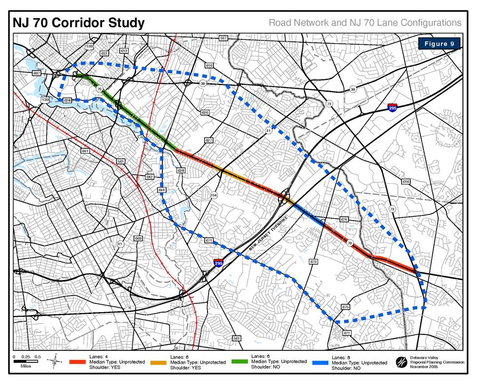
43 3.1 ROAD NETWORK The NJ 70 corridor is well connected to the regional highway system, the county route system, and the local street network (see Figure 9 on preceding page). Table 6 lists the major study corridor facilities and selected characteristics of each. At the western end of the study area NJ 70 connects with US 130 and US 30 via NJ 38. US 130 follows the Delaware River and connects Delaware State with central New Jersey. US 30, known as the White Horse Pike, is a long established route between the Ben Franklin Bridge and Atlantic City. NJ 38 parallels NJ 70 and connects with US 206 in central Burlington County. Between NJ 38 and NJ 41 Kings Highway, several county routes connect with NJ 70 providing north-south access to surrounding neighborhoods and municipalities. Cuthbert Boulevard (CR 636) is the only county facility that meets NJ 70 at a grade separated, full cloverleaf interchange. Cuthbert is the primary access facility to NJ 70 and NJ 38 for residents of Haddon Township, and Collingswood and Audubon Boroughs. It also provides access to the Cherry Hill Executive Campus and the NJDOT State Inspections Station. Other important north-south routes in this section include Haddonfield Road/Grove Street (CR 644), Cooper Landing Road (CR 627), NJ 41 Kings Highway, and NJ 154 Brace Road. Park Boulevard (CR 628) and Chapel Avenue (CR 626) are heavily traveled east-west routes that parallel NJ 70. I-295 is a six-lane interstate highway serving both local and regional traffic needs of southern and central New Jersey, and carries traffic from Delaware. Through the study area, I-295 parallels the New Jersey Turnpike (NJTPK) and interchanges with NJ 70 near the Barclay section of Cherry Hill Township. The turnpike is a four-lane toll freeway carrying traffic from the Delaware state line to the New Jersey/New York border serving higher density population centers in northern New Jersey. North of exit 7 the turnpike is designated as I-95. Interchange four of the turnpike is north of the study area at NJ 73. The turnpike does not have an interchange at NJ 70. Kresson Road (CR 671) and Greentree Road (CR 683) are east-west facilities serving retail and residential destinations in the NJ 70 corridor area. Greentree Road is a heavily utilized connector between NJ 70 and NJ 73. Springdale Road (CR 673) is the main access facility into the Cherry Hill Industrial Park, located east of I-295 on the north side of NJ 70. Cropwell Road (CR 675) carries both regional and local traffic between Old Marlton Pike and Voorhees Township. Both Springdale Road and Cropwell Road are north-south facilities. Located at the eastern end of the study area, NJ 73 is a regional facility that connects the Tacony-Palmyra Bridge to Philadelphia with the Atlantic City Expressway in southeastern Camden County near the Atlantic County border. NJ 73 and NJ 70 meet at a modified traffic circle that incorporates traffic signals. The New Jersey Department of Transportation plans to reconstruct this junction as a grade-separated interchange in three to five years. 31
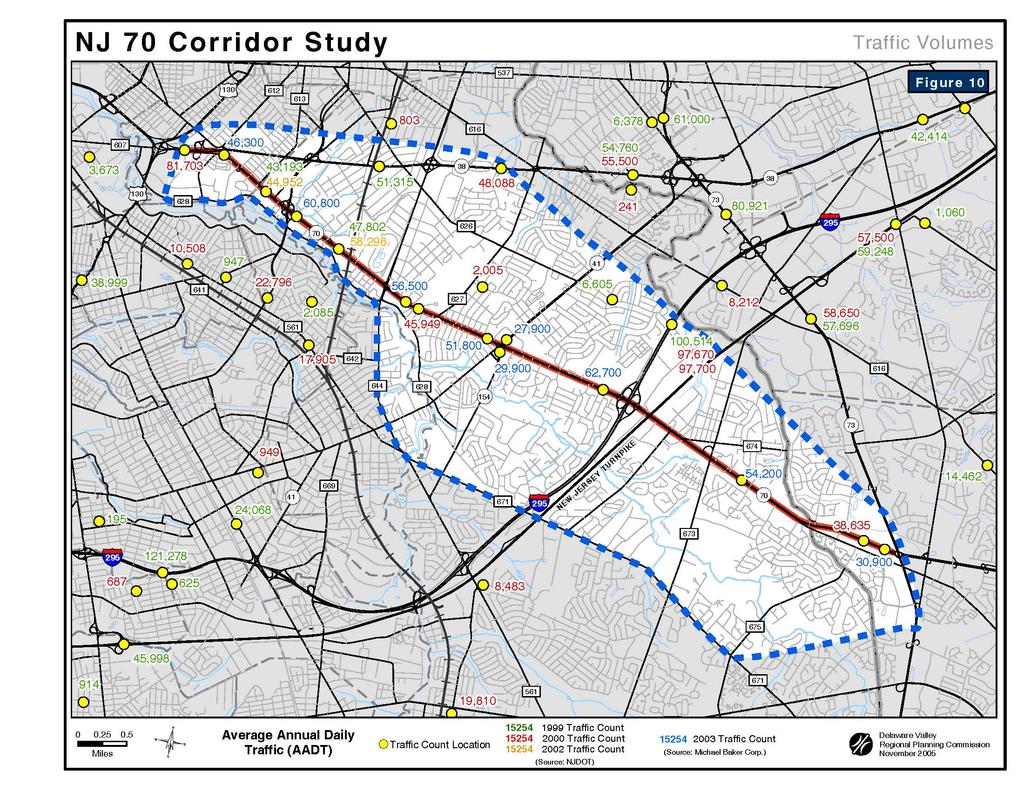
44 TABLE 6 CHARACTERISTICS OF MAJOR STUDY CORRIDOR ROADWAYS Roadway Limits Ownership Functional Classification Lanes by Direction NJ 70 NJ 38 to Curtis Ave. NJDOT Principal Arterial 3 45 Curtis Ave. to Maine Ave. NJDOT Principal Arterial 2 45 Maine Ave. to Sawmill Rd. NJDOT Principal Arterial 3 45 Sawmill Rd. to I-295 NJDOT Principal Arterial 2 45 I-295 to NJTPK NJDOT Principal Arterial 3 45 NJTPK to Springdale Rd. NJDOT Principal Arterial 4 45 Springdale Rd. to NJ 73 NJDOT Principal Arterial 2 45 NJ 38 NJ 70 to NJ 73 NJDOT Principal Arterial Cuthbert Boulevard Haddon Ave. to NJ 38 Camden County (CR 636) Principal Arterial Park Boulevard US 130 to Kings Highway Camden County (CR 628) Minor Arterial 1 35 Haddonfield Rd./Grove St. Kings Highway to NJ 38 Camden County (CR 644) Principal Arterial Chapel Avenue NJ 38 to Old Cuthbert Rd. Camden County (CR 626)/Cherry Hill Twp. Minor Arterial 1 25 Cooper Landing Road NJ 70 to NJ 38 Camden County (CR 627) Minor Arterial 1 40 NJ 41 Kings Highway Haddon Ave. to N 73 NJDOT Minor Arterial NJ 154 Brace Road Haddonfield-Berlin Road to NJ 70 NJDOT Principal Arterial 1 40 Interstate 295 Exit #34 NJDOT Interstate 3 65 New Jersey Turnpike Exit #3 NJ Turnpike Authority Freeway / Expressway 2 65 Kresson Road Haddonfield-Berlin Rd. to Cropwell Rd. Camden County (CR 671) Minor Arterial Greentree Road NJ 70 to NJ 73 Camden County (CR 683) Minor Arterial 1 40 Springdale Road Kresson Rd. to Church Rd. Camden County (CR 673) Minor Arterial Old Marlton Pike NJ 70 to NJ 73 Camden County (CR 600) Minor Arterial 1 35 Cropwell Road Kresson Road to Old Marlton Pike Camden County (CR 675) Minor Arterial NJ 73 Church St. to Greentree Rd. NJDOT Principal Arterial 4 50 Posted Speed (mph) 3.2 TRAFFIC VOLUMES Figure 10 illustrates daily traffic levels occurring along Route 70 and the rest of the study area highway network since Daily demand peaks at two locations on Route 70: 1) the I-295 / New Jersey Turnpike corridor, and 2) Cuthbert Boulevard. The traffic volume is 73,000 vehicles per day near I-295 and around 71,000 vehicles per day at Cuthbert Boulevard. Between these two locations, at Kings Highway, volume drops to around 60,000. East of Cuthbert, near the nexus with Route 38, volume drops further, to 54,000. West of I-295, traffic falls off sharply at Old Marlton Pike (Route 600), a parallel facility. At the intersection with Route 73 at Marlton Circle, volume subsides to 36,000 vehicles per day. Other major facilities within the corridor include I-295 and the New Jersey Turnpike. Daily traffic volumes on I-295 are around 99,000 vehicles per day (2000). The New Jersey Turnpike carries approximately 52,000 daily vehicles, to the east of the Route 70 interchange, and 66,000 vehicles, to the west of Route
45
46 3.3 PUBLIC TRANSPORTATION - BUS Public Bus Transportation in the Corridor Bus transportation within the study area is composed of six bus routes, they are routes 405, 406, 413, 450, 455, 457. Only the Route 406 runs along NJ 70 while the other five either cross or parallel NJ 70. These are illustrated in Figure 11. Philadelphia and/or Camden are the primary origins for these services and their destinations lie just outside the study area at either the Cherry Hill or Moorestown malls (including East Gate Business Center and Mount Laurel Corporate Park). Bus service also runs through employment centers and industrial parks along Route 70, such as the Airport Industrial Park and Cherry Hill Industrial Park. These are significant developments. The other site of note requiring comment is the Garden State Park development project. This is a 223-acre tract being developed as a suburban center with existent access to New Jersey Transit s Cherry Hill railroad station and two other bus routes. Within the study area there are two rail stations with connections to buses: the PATCO Haddonfield station and New Jersey Transit s Cherry Hill station on the Atlantic City rail line. Both of these have service into Philadelphia. The Haddonfield station has connections with the 455 and 457 buses, while the Cherry Hill station has connections with the 450 and the 406 buses. Bus Routes Serving the Study Area Route 405 service runs from Philadelphia to the Cherry Hill Mall via Merchantville, largely running along Maple Avenue (CR 537) to Chapel Avenue (NJ 626) to Haddonfield Road (CR 644) north to the Cherry Hill Mall. Eight trips per day go from the mall along Chapel Avenue to Kingston Estates, which lies just inside the study area. The travel time between Philadelphia and the mall is about 50 minutes per trip while the return trip varies between 33 to 40 minutes. There are 20 trips to the mall arriving between 7:10 am and 10:19 pm for a 15-hour span of service. There are 21 trips departing the mall between 8:14 am and 11:30 pm for a 15- hour span of service. Both outbound and inbound service to the Camden Housing Authority ceases at 5:22 pm, consequently shortening the trip time by about seven minutes. There are nine arriving trips to Kingston Estates and eight departing trips during the typical morning and afternoon peaks. There is also a single midmorning trip leaving 10:26 am and arriving 10:53 am. Route 406 service runs from Philadelphia to Marlton with variations outside the study area to Berlin and Medford Lakes. The bus runs along Marlton Pike (NJ 70) from the intersection of Marlton Pike and Roosevelt Avenue to Marlton Circle (NJ 70 and NJ 73) through the length of the study area. Within the study area there is service from 5:11 am to 1:06 am for a 20-hour span of service. The 406 bus makes about 39 runs per day along the main portion of NJ 70 with eight morning and four evening trip variations to include the Cherry 34
47 Hill Industrial Park. The 406 bus will be discussed in further detail below. am and 9 am, and 4 pm and 7 pm, and hourly service during the off peak. Route 413 runs service from Philadelphia to Burlington via Mt. Holly. It runs through the study area along Kaighn Avenue (NJ 38), with a loop in Pennsauken through the Airport Industrial Park (3 in the morning and 2 in the afternoon), a stop near the Cherry Hill Mall and another loop through the Moorestown Mall. The bus runs from 5:52 am to 1:11 am for a 19-hour span of service. Route 413 makes about 21 trips along the NJ 38 corridor passing through the western portion of the study area. Route 450 runs from Camden to Cherry Hill Mall, passing through the study area in a north-south direction. Buses travel on Cuthbert Road (CR 636) crossing Marlton Pike (NJ 70) and circulating through the Garden State pavilion Shopping Center and making a stop at the Cherry Hill train station (NJT). The bus then exits onto Cuthbert Road again and travels east on Kaighn Avenue (NJ 38) to Haddonfield Road to the Cherry Hill Mall. The first service (from Audubon) commences at 4:40 a.m. with the last bus arriving in Camden at the Walter Rand Transportation Center at 11:08 pm for a 19-hour span of service. There are eighteen outbound and nineteen inbound trips, not including some short-run variations in the morning between Audubon and Camden. There is half-hour service at the Cherry Hill train station during the peak periods between 6 Route 455 runs from Paulsboro to the Cherry Hill Mall, passing through the study area along a north-south axis. Buses travel north on Clements Road (NJ 41) to Kings Highway (NJ 41) connecting with the Haddonfield train station (PATCO), then back onto Kings Highway to Marlton Road (NJ 70) east to Kingston Drive and then west on Chapel Avenue (CR 626), then circling into Cherry Hill Mall via Cooper Landing /Church / Haddonfield roads. The first bus out leaves National Park at 5:47 am while the final bus arrives in Paulsboro at 11:22 pm, for a service span of about seventeen and one half hours. Service runs hourly all day in each direction with eighteen outbound and seventeen inbound trips daily. Route 457 runs from Camden to Moorestown Mall traveling north on Kings Highway (CR 551), to loop around the Haddonfield Train Station (PATCO) where it continues on Kings Highway (now NJ 41), turning east on Church Road (CR 616) and north again on Fellowship Road ( CR 673) looping back at Harper Drive into the Moorestown Mall. The first bus departs the Haddonfield train station inbound to Camden at 5:52 am and arrives in Camden at 11:08 pm for about a seventeen hours span of service. There is hourly service during the off peak and half-hourly service in the peak periods. There are twenty inbound and nineteen outbound trips daily. 35

48
49 Bus Route Boardings Table 7 provides figures for the daily boardings on each route in the corridor. The level of service (LOS) provided by the buses through the corridor is largely west the New Jersey Turnpike where the concentrations of population and employment are located. As noted in the route descriptions, most of the bus service along the corridor connects Philadelphia/Camden with the two regional malls, Cherry Hill and Moorestown. Moorestown Mall. The 450 includes a stop at the Garden State Park site, which is currently being redeveloped, and New Jersey Transit s Cherry Hill Station, where transfers between the modes are minor. The trip frequency for all bus routes is about every 30 minutes, though the frequency increases in the peak hours. Peak hour service in the morning and the evening accounts for between one-third and one-half the total service provided. The daily bus boardings are highest for the 406 bus (2,058 daily) and lowest for the 455 and 457 buses with 792 and 782 boards respectively. The other buses, 406, 413, and 450 have the greatest average boardings. The 413 and 450 buses have the highest average boardings, due in part to frequent connections between Camden and Cherry Hill Mall. The 413 also loops though the Airport Industrial Park and passes the TABLE 7 BUS ROUTE BOARDINGS Route 405 Daily Boards 1,049 Total Trips 45 Avg. Boards Per Trip 23 Peak Trips *AM / PM 8 / 9 Peak As % of Total Trips 38% 406 2, / 15 47% 413 1, / 10 40% 450 1, / 7 37% / 7 37% / 8 47% Source: New Jersey Transit, Median Ridership Report, May 2003 * Peak periods are between 6 am and 9 am and between 4 pm and 7 pm. Patterning of Bus Ridership in Study Corridor The transit customers pattern of movement through, inside, and between the study area and adjoining areas provides insight as to how transit is used. Using New Jersey Transit zonal farebox data matched to the study area, one may generalize about origins and destinations of bus riders in the study area. This information also provides insight into how this movement relates to the corridor. The method samples ridership on the identified bus routes: 405, 406, 413, 450, 455, 457. Three-day samples were taken midweek Tuesday, Wednesday, and Thursday on the 4th, 5th and 6th of November in Geography inside and outside the study corridor were matched with the NJ Transit zones. Ridership was tabulated between these zones. The counted trips include through the corridor, within the corridor, and internal-external trips. Trips occurring entirely outside the study corridor were not tabulated. These totals were averaged to provide a representative daily travel movement. The ridership numbers in Table 8 assume symmetry, meaning that 37
50 the numbers shown express ridership only in one direction. The results are shown numerically in Table 8 below. Table 8 shows the distribution of transit trips along the Route 70 study area. As stated above, these are drawn from fare box counts in November 2003 and are not the same dataset as the average daily boards shown in Table 7. TABLE 8 DISTRIBUTION OF TRIPS (ASSUMES SYMMETRY) Through Internal Phl/Camden Other Route Route Trips Trips Ex In Ex-In Totals % 405 na na % % % 450 na na 131 7% 455 na na 112 6% % Totals % Trip Type 14% 16% 65% 5% Source: New Jersey Transit Farebox Passenger Count, November 2003 There are about 2,015 total riders traveling in and about the corridor in this sample. About 40 percent of these trips are on the 406 bus which travels along Route 70 through the study corridor. The distribution of 406 bus trips through the study area is depicted on Figure 12. The other bus services generally cross the Marlton Pike with destinations at either the Cherry Hill or Moorestown Malls, rather than along the corridor (see Figure 11). The 405 bus, ending at the Cherry Hill Mall and the 413 bus with stops at the Cherry Hill Mall and Moorestown Mall, have other destinations within the study corridor at Kingston Estates and Airport Industrial Park respectively. The large number of through trips on the 413 bus may be explained by the attractiveness of the twin mall destinations. The distribution of trips on other bus routes is somewhat smaller than the total trips shown in Table 7. In these cases the study corridor is not a destination but a through-way, between points with little passenger pick up in between. Table 8 shows nearly two-thirds of all trips in the corridor (65%) originate in the western side of the study area in Philadelphia/Camden. This densely populated area serves as a primary point of origin for employees or shoppers who take transit to the Route 70 corridor. The Walter Rand Transportation Center in Camden is also a transportation hub collecting and distributing trips between north/south bus routes and service to the east. Only 5 percent of the riders are originating to the east of the study area, an area of new growth and residential development, but currently less developed than the urban west side of the study area. The remaining 30 percent of trips move through the corridor and within the corridor. These trips make up about 14 and 16 percent portions, respectively. A number of the bus routes (405, 450, 455) do not have routings or zonal designations which permit through trips to be counted. The through trips generally originate in Philadelphia or just over the Delaware river with about 87 percent of the through trips carried on the 413 bus. 38

51 NJ 70 Corridor Study Route 406 Trip Distribution Figure ZONE 5 ZONE 1 & 2 NJ 70 ZONE ZONE 4 NJ 70 9 NJ Turnpike / I-295 Source: NJ Transit passenger fare 3 day sample 4,5,6 November 2003 Delaware Valley Regional Planning Commission November 2005
52 The breakdown of the 246 through trips has about 70 percent, or 172 trips, between Philadelphia and Pennsauken to the Moorestown Mall. Internal trips originating and arriving within the study corridor make up about 16 percent of the trips. The 455 bus has the greatest route portion of trips within the study area, 73 percent, while the 406 bus has the greatest number of internal trips with 34 percent. Some of these trips may be outside the study area due to zonal anomalies in the tabulations, such as Cherry Hill Mall being included as internal. From the analysis it can be surmised that public transit is not currently being used as a means to travel within the corridor but rather as a means to gain access to employment or shopping from outside the corridor. Public transit is not being used as a mobility option for those residing within the corridor. Transit Issues And Recommendations For NJ 70: Transit service along NJ 70 is inhibited by congestion. Dedicated bus lanes would make transit more efficient. Infrequent headways due to circuitous routing of the 406 bus make it an unrealistic alternative for Philadelphia-bound commuters. Sidewalks are missing or inadequate in many locations, making the connections between bus stops and destinations difficult and unsafe. At some locations, excessive highway width is a problem for pedestrian crossing. Access management will improve efficiency for buses. 40
53 3.4 PASSENGER RAIL TRANSIT connections with two bus lines (Routes 455 and 457) crossing the corridor. Passenger Rail Transit in the Corridor The broad study area is served by regional train service oriented radially to Center City Philadelphia. The PATCO Speedline, operated by the Port Authority Transit Corporation (PATCO) is a regional rail line providing service between Lindenwold and Central Philadelphia via Camden City. Speedline station stops, within the broad study area, are at Woodcrest, Haddonfield, and Westmont. Commuter bus service is available to these stations. The New Jersey Transit Atlantic City Line also stops in Cherry Hill. The station is located near the Garden State Park behind The Pavilions Shopping Center; connecting bus service is provided. It is possible to transfer between the Speedline and the Atlantic City Line at Lindenwold Station. The Cherry Hill and Haddonfield stations are different in boardings, with stops at Cherry Hill about one-tenth the number at Haddonfield. This may be attributed in part to the size of the available parking present at each station. There are 328 parking slots at Cherry Hill, which is one-third the 1,021 parking slots at Haddonfield station. Neither lot, however, is fully used. The parking usage at Cherry Hill is 111 slots (34% of capacity) and at Haddonfield is 960 slots (94% of capacity). When parking use is tabulated, the Cherry Hill station is about 11 percent of Haddonfield s total. The almost 1-to-10 proportion is constant between the two stations in both parking and boardings. Discretionary boards are one-tenth at Cherry Hill station than at Haddonfield, and neither of these is constrained by parking at this time. Rail Boardings Data for boardings at the two rail stations within the corridor are shown in Table 9. The Cherry Hill station is part of a commuter rail service running between Philadelphia s 30th Street Station and Atlantic City, New Jersey. The Cherry Hill station is located at what formerly was the Garden State Park Race Track, just off Route 70. This site is currently being redeveloped into a mixed residential/commercial use. The station is at the western end of the study area. The Haddonfield station is part of the PATCO high speed line. It is located south and west of the study area just off Kings Highway. The Haddonfield station is noted due to its TABLE 9 AVERAGE BOARDINGS AT RAIL STATIONS Peak Stops AM/PM* Peak As % of Total Trips Station Daily Boards Total Stops Parking / % Usage Cherry Hill 159* 28 6 / 7 46% 328 / 34% Haddonfield 1,818** / 54 46% 1,021 / 94% Sources:*New Jersey Transit Quarterly Ridership Trends, October 2001 ** PATCO Weekday Ridership Averages, October
54 This may be attributed to the higher level of peak hour service provided at the Haddonfield station, which is about ten times more frequent than at Cherry Hill Station. The frequency of stops in the peak affects the number of boards at the station. About 46 percent of the service at both stations occurs during the morning and evening peaks, which is not surprising. There are no timed transfers between buses and trains at either of the stations. Timed transfers is inconsequential at the Haddonfield station given the 4-12 minute train headways during the peaks. A traveler could expect a short wait for the train at the Haddonfield station for either the 455 or 457 buses during the a.m. peak period. The Cherry Hill station has less frequent bus and train service, thus making connections with the 450 bus possible, but not convenient. The 406 bus does not stop at the Cherry Hill station, so a walking time penalty may be seen as hampering any sort of transfer. 3.5 BICYCLE AND PEDESTRIAN This section begins with a characterization of current bike and foot travel along the corridor. Discussion will then follow regarding existing conditions for the two modes, the corridor s status in the recently updated Statewide Bicycle and Pedestrian Master Plan, and the design implications of bicyclist and pedestrian needs for capacity enhancement projects on NJ 70. The section concludes with a summary of issues and recommendations. Bicycle and Pedestrian Travel within the Corridor No counts of bicyclists or pedestrians are known to exist for Route 70. Casual observation and both physical and statistical evidence indicate, however, that non-motorized use of the highway right-of-way occurs along the entire length of the corridor. Crashes involving pedestrians are over represented at four intersections widely spaced from each other. Field surveys conducted by Michael Baker Jr. Inc., consulting engineers for the New Jersey Department of Transportation, found worn footpaths at several locations where sidewalks were absent. Research at the national level indicates that areas similar to the corridor in population and employment density in large metropolitan areas generate a small but consistent percentage of trips by bicycle. Nearly 800 daily boardings and alightings of New Jersey Transit s 406 bus line occur along the corridor, generating a like number of walking trips as well as some bicycle trips involving use of the bus bike carrier. More than 80 percent of these trips originate from west of the study area, an overwhelming majority of which start as transfers at the Walter Rand Transportation Center or from East Camden neighborhoods. The ridership of the 406 can be characterized as belonging to minority and disadvantaged populations dependant on the bus for reverse-commuting to the job-rich corridor. Therefore, any measure that would diminish the pedestrian level of service or degrade pedestrian safety would raise a legitimate environmental justice concern. 42
55 Existing Conditions for Bicycling and Walking A comprehensive inventory of pedestrian and bicycle deficiencies along the corridor was performed by Michael Baker Jr. Inc. for NJDOT in This inventory found that sidewalks are present along less than 50 percent of the study corridor length, and in many locations are substandard or in poor repair; curb ramps are missing or substandard; crosswalks and pedestrian signal heads were found lacking at several intersections; and, in general, opportunities for crossing NJ 70 are few and far between. The most onerous feature of Route 70 is its width. Typical of the highway is the 96-foot crossing distance at Marlkress Road. The center median that runs the length of the highway through the study area mitigates crossing difficulty by providing a refuge, enabling the pedestrian to accept gaps in one direction at a time, thereby facilitating the crossing task. With the exception of a gap extending between the New Jersey Turnpike and Springdale Road, the highway has adequate shoulders for bicycling. Just west of this gap is the I-295 interchange. The expressway ramps present a hazard to both pedestrians and bicyclists, as the attentions of merging motorists are focused on finding acceptable gaps, and not on bicyclists and pedestrians. Numerous commercial and residential driveways and a lack of ongoing sidewalk maintenance serve to degrade safety and comfort for both bicyclists and pedestrians throughout the corridor. The Baker study also documented a shortage of bus shelters as well as a lack of sidewalks serving existing shelters in some locations. Land use and urban form within the corridor discourage trips by foot. The highway is fronted to a large degree by autooriented commercial uses. Commercial access is unregulated. By contrast, access to residential areas is highly regulated. With the singular exception of the Erlton neighborhood, residential neighborhoods are located away from the highway, accessed from Route 70 by only one or two streets Barriers are natural or man-made features that break the street pattern preventing or impeding easy non-motorized travel between nearby origins and destinations. Route 70 itself is a barrier. The I-295/NJ Turnpike corridor and the North Branch of the Cooper River are also significant barriers criss-crossing the corridor. These two barriers, in combination with a third, the South Branch of the Pennsauken Creek, effectively bar bicycle and pedestrian access to the Cherry Hill Industrial Park. NJ 70 - Statewide Bicycle and Pedestrian Master Plan In 2004 NJDOT released Phase 2 of the Statewide Bicycle and Pedestrian Master Plan. The plan vision states: New Jersey is a state where people choose to walk and bicycle; residents and visitors are able to conveniently walk and bicycle with confidence and a sense of security in every community; and both activities are a routine part of the 43

56

57
58 transportation and recreation systems and support active, healthy lifestyles. While Phase 1 focused on policies, Phase 2 concentrates on facilities. This emphasis is the result of heightened interest in developing bicycle and pedestrian accommodations to the extent that funding requests for such projects far exceed available funds. Phase 2 is intended to provide clear guidance on prioritization of state investment in bicycle and pedestrian facilities. Phase 2 accomplished this prioritization using analytical methods involving measures of demand and suitability applied to the CMS roadway network. Segments of the CMS network were identified as high priority where demand is high and facilities are least suitable. Bicycle demand is principally a function of demographics and mode split, where a younger population, college students, a high transit mode split and numbers of current bicycle commuters contribute to demand. Pedestrian demand is derived from street network, population and employment densities and the balance of land uses. Suitability is a level-of-service measure, a way of quantifying how comfortable a bicyclist or pedestrian would be traveling along or across a given facility. Bicycle Suitability is determined by roadway characteristics such as traffic speed and volume, presence of shoulders, or shoulder lane width. Pedestrian Suitability, defined as the ability of a person on foot to cross the roadway, factors in the speed and volume of traffic, the presence of a median refuge, and spacing of signalized crossings to determine overall delay from waiting for a safe gap in traffic in which to cross. Details on the analytical methodology used to classify priority segments may be found in the Phase 2 plan document. The Statewide Bicycle and Pedestrian Master Plan Phase 2 indicates Route 70 as high priority for pedestrian improvements from MP 1.03 to 3.2, from MP 4.35 to 5.74, and from MP 7.22 through the eastern end of the study area at Route 73 (see Figure 14). Indicated by the plan as high priority for bicycling improvements are sections between MP 2.34 and 3.0, 3.2 and 4.35, and from 5.08 to 5.4 (see Fig. 15). Design Considerations For An Improved Route 70 The addition of lanes on Route 70 and selected cross streets is a central feature of all alternatives explored to date to alleviate congestion and delay and reduce crashes along Route 70 as discussed in NJDOT s NJ 70 Concept Development Report (October 2004). This feature will increase pedestrian crossing distances, thereby increasing pedestrian discomfort and crash exposure. In addition, turning lanes, channelized right turns, and jug handles may all further degrade pedestrian safety if not designed carefully. Close attention must be paid to details of design geometrics and traffic controls in order to mitigate pedestrian hazards. Ramp and corner geometries must be designed to moderate vehicle speeds and enhance pedestrian visibility. Signal 46
59 progression must allow the pedestrian adequate crossing time and protection from turning vehicles. Signage and pavement markings must alert motorists to the presence of pedestrians. Access management and the retention of shoulders are recommended to reduce conflicts between bicyclists and motorists, and improve pedestrian safety and comfort. Sidewalks should be completed and maintained along the length of the highway. Current design guidance includes AASHTO s Guide to the Development of Bicycle Facilities (1999) and Guide for the Planning, Design, and Operation of Pedestrian Facilities (2004). BICYCLE AND PEDESTRIAN ISSUES AND RECOMMENDATIONS FOR NJ 70: The corridor has small but consistent levels of bicycling and walking Many pedestrians on Route 70 are disadvantaged who use the bus to get to their jobs from Camden neighborhoods. The street network pattern restricts bike and pedestrian travel within the corridor. At some locations, excessive highway width is a problem for pedestrian crossing. Adequate shoulders for bicycling are found along most of the length of the corridor; marking them as bike lanes would increase the profile of bicyclists and may improve safety. Sidewalks are missing or inadequate in many locations, and particularly around bus stops. Capacity improvements must be balanced with pedestrian safety needs, including the moderation of vehicle speeds. Access management will improve safety for bicyclists. 47
60 INSERT: Chapter 1 Title Page 1
61
62 Introduction The crash analysis is a comprehensive safety overview of the study corridor using available crash data. The main goals are to evaluate the corridor study area as a whole, and to identify the most problematic locations. In many cases the results of this analysis substantiated safety problems identified by local officials. More in-depth study will be required to develop the most appropriate improvements. The crash data used in this analysis was obtained from the New Jersey Department of Transportation s (NJDOT) data reference Web page. Data for years 2001 through 2003 were utilized. The crash analysis is divided into three parts: 1) Corridor Crash Summary, 2) Crash Clusters, and 3) Crashes at Unsignalized Median Openings. According to NJDOT, rear-end and sideswipe collisions involve traffic moving in the same direction. Angle crashes involve angular traffic (i.e. northbound and westbound), left turn and head-on events involve opposing traffic. occurred at intersections, with the balance occurring within the mid-block (336 crashes). Seventy-four percent of the crashes occurred during the daytime, which excludes dawn and dusk. NJ 70 Compared to State System Roads As published in the NJDOT At/Between Intersections Accident Summary for State System Roads (excluding toll roads and interstates) 67,013 crashes occurred on the state system during Concerning collision type the NJ 70 corridor exceeds state percentages in two categories, rearend crashes (state: 44%, NJ 70: 55%) and sideswipe crashes (state: 16%, NJ 70: 22%). Same direction-rear end crashes was the most predominant collision type in the study area. Recurring peak period congestion is likely a contributing factor to the higher than average rear-end collisions. Frequent stopping and starting combined with multiple access points along the roadway creates an environment that is conducive to rear-end crashes. During 2003 there were 636 crashes along the 8.33 miles of 4.1 CORRIDOR CRASH SUMMARY, 2003 During 2003 there were 636 crashes along the 8.33 miles of NJ 70 (see Tables 10 and 11). Regarding severity there were 445 property damage only crashes, 190 injury crashes, and one fatality. Combined, rear-end and sideswipe collisions accounted for 77% of the crashes. This is likely because NJ70 is a divided highway. Forty-seven percent (300) Regarding the over representation of sideswipe type crashes, multiple unsignalized median openings found along NJ 70 s four lane cross sections may be a contributing factor. During field observations, vehicles were witnessed queuing in the passing lane for entry into the median opening. Other vehicles were then seen weaving around the queue, an inherently unsafe movement. Although these unsignalized median openings create situations that compromise safety as they encourage the crossing of live lanes of traffic, they also provide access to retail, employment, and neighborhoods on 50
63 the opposite side of NJ 70. They are also used to make U- turns. A comprehensive approach which creates multiple safe access points should be considered. A summary of all collision types and other select data items are included in Tables 10 and 11. There were five bicycle-related crashes on NJ 70 during 2003 accounting for 0.79% of the total. This percentage is significantly higher than the state percentage of 0.47%. Although biking is not prohibited on NJ 70, the biking environment is undesirable, i.e.: multiple lanes of fast moving traffic and lack of bike lanes. There were four pedestrian related crashes on NJ 70. Although the percentage did not exceed the state average (ped crashes: NJ 70, 0.63%; state, 0.78%), this is still a relatively high number deserving further investigation as to where the crashes occurred and the current state of pedestrian amenities at those locations. Generally speaking, most of NJ 70 is pedestrian unfriendly and only a few safe crossing opportunities exist. One exception is NJ 70 through the Erlton neighborhood. An analysis of NJ 70's pedestrian environment is provided in section
64 TABLE 10 NJ 70 CORRIDOR CRASH SUMMARY, MILE POST , 2003 NJ 70 Total Crashes = 636 State Total = 67,013 Collision Type NJ 70 Count % of Total State Count % of Total Same Direction - Rear End % % Same Direction - Sideswipe % % Angle % % Head-On % % Left Turn % % Struck Parked Vehicle % % Other/Unknow % % Overturn % % Pedestrian % % Fixed Object % % Animal % % Pedacycle % % During year 2003, the study area portion of NJ 70 exceeded the state threshold for rear-end and sideswipe crashes. Intersection NJ 70 Count % of Total State Count % of Total Not at Intersection % 37, % At Intersection % 29, % At or Near Railroad Crossing % % Light NJ 70 Count % of Total State Count % of Total Unknown % % Daylight % % Night, Dawn, Dusk % % Severity NJ 70 Count % of Total State Count % of Total Fatal % % Injury % % Property % % Surface Condition NJ 70 Count % of Total State Count % of Total Unknow/Other % % Dry % % Wet % % Snowy/Icy % % TABLE 11 NJ 70 CRASHES BY DIRECTION, MILE POST , 2003 Direction of Travel Count % of Total Unknown % North % East % South % West % 52
65 4.2 CRASH CLUSTERS Methodology For the purposes of this study, a cluster is defined as a section of roadway up to one-tenth-mile long where a minimum of 24 crashes occurred during years 2001 to Analysis sections were determined by graphing all crashes for the three year period and qualitatively examining the concentrations along the corridor. Eight crashes per year over a 0.4 mile section is the minimum threshold for analysis as stated in the New Jersey Department of Transportation s annual safety report. Using DVRPC s method, twenty-two clusters were identified within the 8.33 mile study area on NJ 70 during the analysis period (see Table 12). TABLE 12 NJ 70 CRASH CLUSTERS >= 24, (West to East) # Mile Post Range Total Crashes Total Killed Total Injured Property Damage Only Predominant Collision Types (# of crashes) Predominant Direction of Travel (# of crashes) Rear End (27) Sideswipe (9) East (26) West (15) Rear End (24) Sideswipe (12) West (21) East (19) Rear End (13) Sideswipe (10) West (19) East (9) Rear End (37) Sideswipe (7) West (32) East (20) Rear End (41) Angle (10) West (33) East (26) Rear End (40) Sideswipe (11) West (34) East (17) Rear End (25) Sideswipe (11) West (31) East (14) Rear End (48) Sideswipe (17) East (42) West (29) Rear End (24) Angle (10) East (29) West (7) Rear End (38) Sideswipe (10) West (31) East (23) Rear End (58) Angle (14) West (46) East (27) Rear End (27) Angle (9) East (26) West (8) Rear End (38) Sideswipe (22) West (56) East (14) Rear End (71) Angle (14) West (83) South (10) Rear End (17) Sideswipe (5) East (13) West (11) Angle (22) Rear End (20) East (23) South (20) Rear End (48) Sideswipe (22) West (38) East (27) Rear End (37) Sideswipe (13) East (29) West (26) Rear End (54) Sideswipe (9) East (44) West (24) Rear End (21) Sideswipe/Angle (2)/(2) East (13) West (11) Rear End (27) Sideswipe (12) East (23) West (18) Sideswipe (99) Rear End (96) West (101) East (73) 53
66 Combined, the 22 clusters total 1,479 crashes, or 78% of the three year analysis period total of 1,892. Figure 15 shows a graphic representation of crash frequency by mile post on the NJ 70 straight line diagram. The frequency of crashes within the clusters ranges from 26 to 250. The cluster frequency average is 67, and 77% of the clusters had between 44 and 87 crashes. Three locations had crash totals below 44, and only two locations had more than 87 crashes. The cluster statistics were compared to 2003 statewide statistics in an effort to identify overrepresented categories. These comparison tables are located in the Appendix. Next is a brief discussion regarding the characteristics of the top five cluster locations. The following observations were made: Mileposts : 250 crashes, 73 eastbound, 101 westbound, 40 southbound, 36 northbound The Marlton Circle is at the location of this crash cluster. This confluence of NJ 70 and NJ 73 is a high priority location for the State of New Jersey due to poor operations and high accident numbers. With 250 crashes, the Marlton Circle is the most dangerous location in the study area exceeding the next highest cluster total by 145 crashes (105 crashes were recorded in the vicinity of Old Cuthbert Road). The New Jersey Department of Transportation is moving forward with an improvement project for this location which calls for the elimination of the circle and replacement with a grade separated interchange. The new interchange was designed to address congestion, mobility, and safety while retaining access. Mileposts : 105 crashes, 8 eastbound, 83 westbound This crash cluster is at the eastern end of the most congested section of NJ 70 and has the second highest total crash number at 105. With 83 of the accidents having occurred on NJ 70 westbound it is clear the problem is particularly acute in that travel direction of the facility. The intersection of NJ 70 westbound at Old Cuthbert Road is at the center of this cluster location. NJ 70 has four westbound lanes to which Old Cuthbert has single lane right-in right-out access. No access to NJ 70 eastbound is provided. There were 71 rearend crashes, 50% more than the state average (NJ 70-67%, state-44%). Westbound back-ups during the morning peak period congestion often times stretch into this location, most likely contributing to the higher number of rear-end crashes. Angle crashes are also over represented 13% versus the state average of 12%. Angle crashes generally do not involve same direction traffic. Thus, the high number (14 angle crashes during ) may be a result of inaccurate crash coding. Mileposts : 87 crashes, 27 eastbound, 38 westbound, 14 northbound This cluster includes the intersection of NJ 70 and CR 674 Greentree Road at milepost 5.75 situated at the eastern end of the catchment area. Greentree Road meets NJ 70 at an oblique angle. Left turns from NJ 70 (both directions) to 54
67 Greentree Road are accommodated via jug handles that utilize Marlkress Road. Rear-end and sideswipe crashes each exceed state averages at 55% (state-44%) and 25% (state-16%) respectively. Local officials reported frequent conflicts between the Greentree southbound traffic merging via channelized right turn with NJ 70 westbound through traffic. In examining the data the highest concentration within the cluster, 65 crashes, is located at milepost 5.74 which is approximately 53 feet east of the intersection. This is the spot where the channelized right turn from Greentree Road and NJ 70 westbound meet. Problems with this merge may be contributing factors to the high number of rear-end and sideswipe crashes. Sight distance is commonly compromised in this type of alignment forcing motorists to rely on the rearview mirror. Also in this cluster a side street meets NJ 70 just west of the merge from Greentree Road, possibly further exacerbating the problem. One pedestrian related crash was also recorded in this cluster. Mileposts : 87 crashes, 27 eastbound, 46 westbound At the center of this cluster East Gate Drive intersects NJ 70 eastbound. In addition there are two unsignalized median openings, one located on the east side of the intersection and the other on the westside, roughly 250 feet apart. This cluster is also within the most congested section of the corridor study area which likely contributes to the over representation of rear-end crashes (NJ 70-66%, state - 44%). Angle and left turn crashes also exceed statewide percentages at 16% and 4% respectively. These collision types are common where traffic is turning left, most likely utilizing the unsignalized median openings. Between Kingston Road and Covered Bridge Road intersections, which are approximately one half mile apart, there are three median openings and one left turn only opening for NJ 70 westbound traffic. The highest concentration of crashes is in the vicinity of milepost 4.61, which is the location of the west side median opening. This opening appears to be the most unsafe. Because there are additional opportunities to cross NJ 70 in this area, the median opening at milepost 4.61 should be closed or replaced by a safer left turn/u-turn opportunity. The high number of crashes at this location is most likely an indication of frequent use of the opening by left and u-turning traffic. Closing this median break may result in shifting the problem to another location. Clearly there is a need for access in this densely developed retail area. Mileposts : 76 crashes, 42 eastbound, 29 westbound At this location NJ 70 meets NJ 41 Kings Highway at a multilane signalized intersection. Left turns from NJ 70 are accommodated via forward jug handles. Rear-end, sideswipe, head-on, and pedacycle crashes are over represented. This is a location of heavy volume and complex turning movements, possibly contributing to the high number of rear-end crashes. 55

68 FIGURE 15: Crash Clusters by Mile Post This graphic depicts crash frequency by mile post along a two-mile section of NJ 70 for years The orange bands represent the cluster catchment area of less than or equal to one tenth mile. The encircled number at the top of each band is total number of crashes within the catchment area during the period. Graphics representing the entire NJ 70 study area are included in the appendix. 56
69 4.3 CRASHES AT UNSIGNALIZED MEDIAN OPENINGS In an effort to quantitatively examine the safety concerns associated with the 21 unsignalized median openings or cutthroughs within the study area, crashes in the vicinity of each location were analyzed. The New Jersey Department of Transportation s State Highway Access Management Code defines a median opening as a paved area bisecting opposite directions of a divided roadway. A median opening is designed to permit traffic to cross at least one direction of travel. Also known as cross-overs or median-breaks, along NJ 70 these are found only in the four lane cross sections of the facility. One exception exists along a six lane cross section in the western portion of the study area near Delaware Avenue and the former Gate 4 entrance to Garden State Park (mile post 2.07). Field observation revealed three types of openings along the corridor. The most common is the two-way median opening that can accommodate roughly two vehicles, usually entering from opposing directions. The second is also two-way, but is wider and can accommodate several vehicles. The third variety serves traffic from one direction only, is typically curved to channel vehicles for left turns or U-turns, and includes a stacking lane. There are five of these openings within the study area. Purpose of Median Openings The purpose of these unsignalized median openings is to provide motorists with additional access opportunities to supplement the signalized intersections. Since NJ 70 is a divided highway, left turns and U-turns would otherwise be restricted to the signalized intersections as is the case in the six and eight lane cross sections where these opening are not provided. In particular, the openings provide the motoring public with more opportunities to reach commercial, employment, and residential destinations land uses that are characteristic of the four lane cross sections of NJ 70. Methodology The crash analysis method utilized NJDOT s straight line diagram to identify the approximate milepost location for each opening and used that location as the center point of a 210 foot total swath (4/100 of a mile). This length was considered the catchment area in an effort to include crashes that were a result of vehicles queuing to enter the opening, and crashes involving vehicles leaving the opening. Data were drawn from years Table 13 lists each location, total crashes by milepost, and other selected crash characteristics. Figure 16 shows crash frequency by milepost along the NJ 70 roadway cross section using NJDOT s straight line diagram. On this graphic median openings are marked and their corresponding catchment crash totals are labeled. 57
70 Identified Problems Access opportunities is the up side to the unsignalized median opening. Compromised safety is the downside. In the case of NJ 70 these openings allow motorists to cross or enter two live lanes of traffic in an unprotected movement a potentially dangerous situation. There are several things to consider regarding median openings. When traffic volumes on the main line are low, gaps in the oncoming flow equate to more opportunities to cross or enter the opposing lanes of traffic. Although on NJ 70, low volumes allow for higher average speeds due to its multi-lane cross section. As speeds increase, turning time is reduced and the probability of a more serious collision increases. When volumes are higher the situation is reversed fewer gaps are available. If volumes grow to the level of congestion causing traffic to move at a stop and go pace, motorists using the openings may find opportunities to cross or enter via the courtesy of drivers in the through traffic stream. On the contrary, motorists in the congestion may be frustrated and don t want to be further delayed by allowing another vehicle in front of them. Although the potential for collisions is moderate in this situation, the severity is reduced because the speed of main line traffic is reduced. TOP 5 CRASH LOCATIONS The following five locations had the highest crash frequency of the 21 median openings. Of the 5, the lowest crash total was 27, more than double the next highest location of 11 crashes. (west to east) 1) Cooper Landing Road, MP 2.92 Total Crashes: 31 crashes Direction: 13 WB, 9 SB, 7 EB, 1 NB Collision Type: 17 rear-end, 7 sideswipe, 3 angle Severity: 0 fatals, 10 injury, 21 property damage This opening serves eastbound traffic only with a left turn stacking lane. It is the first opportunity to cross the highway from the eastbound direction after the Haddonfield Road intersection. Also, Cooper Landing Road serves a dense network of residential streets and carries traffic northeast to Maple Shade Township. 2) Maine and Vermont Avenues, MP 3.41 Total Crashes: 36 crashes Direction: 22 WB, 11 EB, 2 SB, 1 SB Collision Type: 18 rear-end, 8 sideswipe, 6 angle Severity: 0 fatals, 14 injury, 22 property damage This opening is located just approximately ¼ mile west of the Kings Highway intersection where NJ 70 westbound narrows from 3 to 2 lanes. It is a narrow two-way median break. Westbound NJ 70 traffic commonly races from the intersection to avoid merge problems at the transition. This, combined with vehicles utilizing the opening, and in some cases vehicles queing to get into the opening, creates a safety hazard. 58
71 3) Between Sawmill Road and Kingston Road, MP 4.12 Total Crashes: 36 crashes Direction: 23 EB, 6 WB, 4 SB, 3 NB Collision Type: 19 rear-end, 5 sideswipe, 9 angle Severity: 0 fatals, 18 injury, 18 property damage This opening location allows NJ eastbound traffic to make a U-turn to get into the Sawmill Village retail strip mall. In addition, this opening can be utilized by local drivers from Saw Mill Road enroute to NJ 70 westbound. This location is also within close proximity to the lane transition (3 to 2) on NJ 70 eastbound. 4) Between Ranaldo Terrace and East Gate Drive, MP 4.61 Total Crashes: 59 crashes Direction: 41 WB, 13 EB, 2 SB, 2 NB Collision Type: 44 rear-end, 5 angle, 3 sideswipe Severity: 0 fatals, 26 injury, 33 property damage This opening is off-set from E.ast Gate Drive, Ranaldo Terrace and the entrance into The Barclay retail center. It is also between two other openings, all of which are situated within one tenth of a mile. At these three locations combined there were 94 crashes. With the majority of crashes occurring westbound, it may involve traffic exiting Barclay shops then using this median opening to access NJ 70 westbound. 5) Between East Gate Drive and Pine Valley Road, 4.66 Total Crashes: 27 crashes Direction: 14 EB, 5 NB, 4 WB, 4 SB Collision Type: 13 rear-end, 9 angle, 2 sideswipe Severity: 0 fatals, 7 injury, 20 property damage This opening is the last of four (eastern most) in this section located between MP 4.42 and MP 4.66 between Kingston Road and Covered Bridge Road intersections. Motorists may use this opening more frequently because it is the last opportunity to make a u-turn from NJ 70 eastbound before the signal at Covered Bridge Road. Observations from the Median Openings Crash Summaries, : Five locations had crash totals of 27 or higher, and the highest had 59 crashes. All other locations had 11 or fewer crashes, and one location had no crashes. Rear-end crashes were the most common collision type accounting for 60% of all crashes. Sideswipe and angle crashes accounted for 13.5% each. Forty five percent of the crashes occurred in the westbound lanes and forty percent occurred in the eastbound lanes. Six median openings are within crash clusters identified in section 6.2 (Crash Clusters) of this report. Five of the six locations are the openings where 27 or more crashes were identified. High crash numbers at a location may be an indication of usage, i.e. more crashes take place at openings where higher demand exists. 59
72 TABLE 13 CRASHES IN THE VICINITY OF UNSIGNALIZED MEDIAN OPENINGS ALONG NJ 70, Opening Location of Unsignalized Median Opening (west to east) Mile Post (aprx.) Left Turn Stacking Lane/ Direction Width in Car Lengths (aprx.) Catchment Area = 210 feet (aprx.) Mile Post # of Crashes Total Crashes Major Crash Type Direction Of Travel 1 At Delaware Avenue and Garden State Park Gate No Rear-end East (4 ), West (7 ) # of crashes At Entrance to Locustwood Park 2.70 Yes / Rear-end East (5 ), West (2 ) # of crashes Eastbound At Whitman Avenue 2.77 No Angle East (4 ), West (2 ) # of crashes At Conwell Avenue 2.83 No Rear-end East (3 ), West (5 ) # of crashes At Cooper Landing Road 2.92 Yes / Rear-end East (7 ), West (13 ) # of crashes Eastbound South (9 ) 6 Between Virginia Avenue and Connecticut Avenue 3.09 No Rear-end East (4 ), West (7 ) # of crashes Between Madison Avenue and Harrison Avenue 3.21 No Rear-end East (1 ), West (2 ) # of crashes Between Vermont Avenue and Maine Avenue 3.41 No Rear-end East (11 ), West (22 ) # of crashes Between Brookmeade Drive and Sawmill Road 4.06 No Rear-end East (3 ) # of crashes Between Sawmill Road and Kingston Road (west) 4.12 No Rear-end East (23 ), West (6 ) # of crashes Between Sawmill Road and Kingston Road (east) 4.18 No Rear-end East (6 ), West (1 ) # of crashes Between Kingston Road and Bark Lake Terrace 4.42 No Rear-end East (3 ), West (6 ) # of crashes Between Ranaldo Terrace and East Gate Drive (east) 4.55 Yes / Rear-end East (1 ), West (6 ) # of crashes Westbound Between Ranaldo Terrace and East Gate Drive (west) 4.61 No Rear-end East (13 ), West (41 ) # of crashes Between East Gate Drive and Pine Valley Road 4.66 No Rear-end East (14 ), West (4 ) # of crashes North (5 ) 16 Between Springdale Road and Birchwood Drive (west) 6.32 No Rear-end West (3 ) # of crashes Between Springdale Road and Birchwood Drive (east) 6.39 No Rear-end East (1 ) # of crashes At Birchwood Road 6.61 Yes / Rear-end East (4 ), West (5 ) # of crashes Eastbound Between Birchwood Road and Old Orchard Road (west) 6.74 No Rear-end East (2 ), West (1 ) # of crashes Between Birchwood Road and Old Orchard Road (east) 6.8 No Rear-end East (3 ) # of crashes Between Old Orchard Road and Split Rock Drive 7.09 Yes / NA NA # of crashes Westbound
73 FIGURE 16: Crash Frequency by Mile Post at Median Openings This graphic depicts crash frequency by mile post along a two-mile section of NJ 70 for years The blue bands represent the cluster catchment area, centered on the median openings, which are marked by a blue star. Each catchement area is approximately 210 feet or five 1/100ths of a mile. The encircled number at the top of each band is total number of crashes within the catchment area during the period. 61
74 Conclusions The purpose of the openings is increased access, mainly to businesses. Retail and commercial development is predominant along NJ 70 in both locations where the median openings are found. Thus, there is clearly a need for access across NJ 70. Congestion is also common in these same locations, specifically during the peak periods in the Erlton and Barclay neighborhoods. High levels of congestion are undesirable and tend to produce low severity crashes. Although, the most unsafe situation regarding use of the openings is when travel speeds are high. This is because judging the velocity of oncoming traffic is difficult for everyone, especially for younger and older drivers, and during dusk, dawn, and bad weather conditions. This situation is compounded when crossing multiple lanes. locations are highly utilized, thus increasing the probability for crashes. Two locations of note, one near Maine Avenue and the other near Sawmill Road, are in the vicinity of lane transition areas, i.e: where lanes narrow from three to two. These openings may be more frequently used because they provide the first opportunity to cross NJ 70 following the three lane sections. This is clearly the case at Maine Avenue. At Sawmill Road, the median opening in question is actually the second from the lane transition, located approximately 500 feet east of the first. Sawmill Road enters NJ 70 eastbound between the two openings. The second opening is likely used by residents traveling on Sawmill Road as an access to NJ 70 westbound. Peak period congestion typically occurs during the a.m. and p.m. rush hours. Retail establishments barring convenience stores, coffee shops, and the like typically keep hours that begin and end outside of the peak commuting times. This suggests a weak correlation between median opening related crashes and congestion. Albeit, congestion delays due to automobile accidents are inevitable. This analysis found that not all median openings are dangerous in terms of accident frequency. That is, actual crashes during the three year period, not potential for accidents (which was not measured). Five of the twenty one median openings met or exceeded the criteria of twenty four crashes during As stated earlier it is likely these Recommendations A comprehensive evaluation that considers access needs, local circulation, and safety concerns should be undertaken. A wholesale closing of all median openings will not address these issues. Instead it will greatly compromise access and create congestion at nearby signalized intersections as turning traffic is forced to those locations. A full scale reevaluation of these treatments may recommend a greater number of signalized intersections to accommodate turns, better designed median openings that are more appropriately located, and stricter access management provisions. The improvement scenario must utilize a multi-pronged approach. 62
75
76 Introduction The transportation issues identified in the NJ 70 Corridor Study have been divided into five categories for the purposes of this report, they are: Corridor-wide Issues, Identified Problem Locations and Potential Improvement Scenarios, Cutthrough traffic, Signs, and Access Management/ Mobility Considerations. 5.1 CORRIDOR-WIDE ISSUES NJ 70 is a state facility that serves both regional and local traffic, a mix of work commuters and consumers. As well, some sections of NJ 70 are considered a default main street for its adjacent neighborhoods. In response to these diverse and varied needs NJ 70 has been developed to accommodate higher volumes and higher average speeds while still providing access to service, retail, and residential developments. As traffic volumes have steadily risen over time, the regional needs of the corridor seem to have been given priority over the local needs. The result, generally speaking, has become free-flowing traffic movement in the 6 and 8 lane sections, while the 4 lane sections have become the location of traffic bottlenecks. When examining typical conditions on NJ 70 one finds motorists slowing down from mph as they transition into the 4 lane sections from the 6 and 8 lane sections, and speeding up dramatically when leaving the four lane sections. For traffic traversing the length of the study area on a regular basis (commuters), an expectation of maintaining a higher average speed has been created in the 6 and 8 lane sections. A problem occurs when this expectation is not met as commuter traffic must deal with the additional traffic generated by the significant land developments that are accessed primarily via NJ 70. Limited access across NJ 70, a compromise inherent in a divided highway configuration, further exacerbates this problem as intersections and jug handles fail to provide enough capacity during peak periods. This is due to both land constraints and relatively wide spacing of signalized intersections. At present, many of the 17 signalized intersections within the study area are performing poorly, some are failing. Cherry Hill Township is densely developed with in-fill development ongoing, and to the east the municipalities served by NJ 70 are growing rapidly. NJ 70 cuts through the heart of Cherry Hill. Cherry Hill s various neighborhoods and business owners perceive NJ 70 s function and purpose is differently. Without being able to recreate this landscape from scratch to accommodate everyone, no single tool will meet all the needs of those who use NJ 70. The bullet point items listed on the following page are intended to encapsulate the larger issues that currently plague operations on NJ
77 IDENTIFIED CORRIDOR-WIDE ISSUES ON NJ 70 Recurring peak period congestion. Limited number of signalized intersections providing direct access across NJ 70. Inconsistent intersection configurations throughout the corridor compromise driver expectation, i.e.: forward jug handles, reverse jughandles, and traditional intersections. Poorly placed signage exacerbates intersection inconsistency. Densely populated neighborhoods isolated from the larger road network causes their few access points to become overburdened due to lack of connectivity, funneling effect. Automobile oriented developments reduce suitability for mass transit options. Unrealistic driver expectation of high average speeds, akin to that of interstate facilities, is incompatible with the retail and residential dominated landscapes characteristic of the study corridor. Multiple crash cluster locations indicating safety problems related to poor operations. CORRIDOR-WIDE IMPROVEMENT STRATEGIES Conduct an origin and destination study and/or license plate survey to define the travel patterns of the NJ 70 commuter. Test suitability of express bus service between Philadelphia from Medford Identify opportunities to connect land uses. This will require a detailed review of aerial photographs by those who have an intimate knowledge of the local land uses, neighborhoods, and travel patterns between. This must be a working effort between the study team and municipal representatives. Install improved signage that is more visible, more clearly worded, and better placed. Develop long term, context sensitive improvements that maintain existing access points, create new access points, and normalize average speeds. Safety improvements 65

78
79 5.2 IDENTIFIED PROBLEM LOCATIONS AND POTENTIAL IMPROVEMENT SCENARIOS Introduction The following location specific problems were identified through meetings and field visits with representatives from each of the study area municipalities (see Figure 17). Follow up visits to the field were conducted by staff during off peak and peak periods to gather data and examine typical conditions. After the initial data gathering was complete and the problem areas defined, determinations were made concerning the regional significance of each location. As a result, those problems deemed to be of greater local significance than regional, were excluded. This exercise is an important step in keeping the study focused on the corridor. MARLTON CIRCLE: CONFLUENCE OF NJ 70 AND NJ 73 > MILEPOST 8.33 The Marlton Circle was not analyzed in this report because the New Jersey Department of Transportation has a plan for reconstruction already underway. The plan is to eliminate the circle and replace it with a grade separated interchange. The transportation improvement program project number is DB# 567 and titled Routes 73 / 70 Marlton Circle Elimination (5) The Marlton Circle, at the intersection of Route 70 and Route 73, will be eliminated; a grade-separated interchange (Route 73 over Route 70) will be constructed. The primary objective is to improve traffic flow and thereby reduce congestion on Route 73 and Route 70 through the intersection. The circle was included in the crash analysis (section 4.0). 1. NJ 70 WESTBOUND / CURTHBERT BOULEVARD / EXECUTIVE CAMPUS > MILEPOST 1.12 Follow-up visits to the study area were conducted by staff during off-peak and peak periods to gather data and examine typical conditions. Identified Problem At this location conflicts were noted between traffic exiting the executive campus to NJ 70 westbound and traffic on 70 westbound en route to the Cuthbert Boulevard northbound off-ramp. Additionally, this weave length is relatively short thus increasing the probability for crashes. The executive campus access to NJ 70 westbound is controlled by a stop sign. The alignment of this approach makes this access function more like a driveway than a ramp. Field observations confirmed free flowing traffic 67

80 and seemingly higher speeds on NJ 70 westbound at this location. This is caused in part by the natural down grade of the facility westbound, three lanes of traffic, and few developments along this stretch. A crash cluster as defined in the safety analysis was not identified at this location. Vehicle exiting Executive Campus to NJ 70 westbound Local officials identified this location of NJ 70 as site of regular pedestrian crossings. During one field visit a pedestrian was observed attempting to cross NJ 70 after disembarking from the eastbound NJTransit 406 bus. Potential Improvement Scenario There is presently no other location for traffic from the executive campus to access NJ 70 westbound. Until an alternative is developed this access point must remain open. In the interim safety measures should be implemented to alert motorists on NJ 70 westbound of the traffic entering from the executive campus, i.e. signage, flashing beacon. Similar safety improvements are also appropriate for traffic exiting the executive campus into NJ70 westbound. 68


81 2. CORNELL AVENUE JUG HANDLE FROM NJ 70 WESTBOUND > MILEPOST 1.6 Identified Problem According to local officials NJ 70 westbound traffic frequently misses the right turn near-side jug handle access to The Pavilions shopping center. Traffic then attempts to turn right at the Cornell Avenue intersection where right turns are prohibited. Currently a sign is located to the east of the NJTransit rail over pass, in advance of the near-side jug handle, that reads SO. CORNELL AVE, directing traffic for the U-Turn and jug handle. There are also smaller signs at this location Visual clutter along NJ 70 westbound advertising the fast food establishments located in the shopping center. On the west side of the rail overpass there are more signs displaying the same information at the jug handle ramp entrance. Potential Improvement Scenario New and improved signs should be placed in advance of the jug handle and at the jug handle ramp. Signs should be very explicit and used in tandem with reflective roadway markings. These signs should make it very clear that to enter the shopping center, traffic must utilize the near side jug handle. Adding the signs that indicate the distance to the jug handle (i.e., 1/4 mile on right ) will better inform the motorist. NJ 70 westbound at entrance to Cornell Ave. jug handle 69

82 3. ATLANTIC CITY RAIL LINE BRIDGE OVER NJ 70 > MILEPOST 1.84 Atlantic City Rail Line overpass with posted height restriction Identified Problem NJ 70 passes under the Atlantic City Rail Line bridge carrying three lanes per direction a six lane cross section. According to local officials truck traffic is sometimes diverted through neighborhoods to avoid this underpass due to inadequate clearance. The vertical clearance under the bridge is posted at The Geometric Design of Highways and Streets 2004 (American Association of State Highway and Transportation Officials) states: Existing structures that provide clearance of 14 ft, if allowed by local statute, may be retained. In highly urbanized areas, a minimum clearance of 14 ft may be provided if there is an alternate route with 16 ft clearance. Potential Improvement Scenario Short Term - Develop a truck route to accommodate those trucks forced to use an alternate path due to the low clearance of the over pass. This effort should involve officials from state and local law enforcement, local businesses, trucking firms, and local government, i.e.: Cherry Hill Township. This type of cooperative approach is low cost, although it requires a high level of buy in by all parties involved. Long Term - Raising the bridge is a high cost, large-scale improvement, albeit an effective one. If such an improvement is considered, it would be prudent to time the project to coincide with the proposed widening slated for the Garden State Park redevelopment project. 4. PENN AVENUE JUG HANDLE > MILEPOST 1.95 Identified Problem Although the number of signs for this near- side jug handle are sufficient, the information is somewhat unclear, and the sign placement can be confusing for the motoring public. Local representatives reported that NJ 70 westbound traffic often misses this jug handle for Haddonfield Road northbound causing them to make a U-turn from Haddonfield Road southbound a move that can be very difficult. 70

83 Potential Improvement Scenario Existing signs should be replaced with new signs that make it very clear to motorists that to access Haddonfield Road northbound all traffic must utilize this jug handle. Haddonfield Road northbound jug handle entrance 5. GARDEN STATE PARK REDEVELOPMENT > MILEPOST 2.07 Cherry Hill Township is currently undergoing one of the largest redevelopment projects the community has ever seen. When finished, the former Garden State Park horse racing complex will be the site of a mixed use development containing 1,652 residential units, 608 age restricted units, 285 affordable units with the balance as high-density. In addition to housing there will be one million square feet of office space, and two million square feet of retail. Some of the planned transportation improvements include the widening of Haddonfield Road to accommodate access to the site and projected additional traffic, and a new road between the existing stable entrance on Haddonfield Road and NJ 70 that follows the western perimeter of the property. Also, a new right in right out access point will be added to the retail complex fronting NJ 70. The impact of this project in terms of trip generation and level of service on surrounding facilities was considered in NJDOT s NJ 70 Concept Development Report. The total trip estimates are as follows: 2,662 a.m. peak hour trips; 4,490 p.m. peak hour trips; and 3,944 Saturday peak hour trips. 71

84 Garden State Park Redevelopment: Identified Potential Problems Impact of additional trips to NJ 70, and to parallel and perpendicular roads resulting in neighborhood cut through routes and a possible reduction in safety Impact of increased traffic and wider roads on pedestrian and bicycle movements Expanding of current weekday and weekend peak period congestion Potential Improvement Scenarios Identify transit opportunities that provide alternatives to automobile trips, i.e. neighborhood shuttle buses, connections between transit hubs and shopping destinations Identify important pedestrian crossings and develop improvements which promote safety and accessibility Implement traffic calming measures and traffic management techniques which facilitate safe and efficient flow of vehicles while maintaining quality of life 6. INTERSECTION OF CR 644 HADDONFIELD ROAD AND WYNWOOD AVENUE > MILEPOST 2.31 (NJ 70) Identified Problem Haddonfield Road meets NJ 70 at a signalized intersection. Wynwood Avenue, which serves residential traffic and serves as a jug handle for traffic from NJ 70 westbound, meets Haddonfield Road at a signalized intersection approximately 500 feet north of the Haddonfield Road/NJ 70 intersection. The close proximity of these two signal sets sometimes creates confusion for motorists traveling southbound on Haddonfield Road. A safety problem occurs when southbound Haddonfield Road traffic fails to notice the Wynwood Avenue signal instead paying attention to the signal at NJ 70, sometimes running the red light signal at Wynwood Avenue. Haddonfield Road southbound at Wynnewood Avenue 72

85 Potential Improvement Scenario Improvements at this location are needed to create greater awareness of the signal controlling the intersection at Wynwood Avenue and Haddonfield Road for motorists traveling southbound on Haddonfield Road. The following improvements are commonly used to achieve this goal and would be effective at this location: 1) Replace the signal head at Haddonfield Road and NJ 70 with an optical head which is only visible when approaching the signal from a relatively short distance away, 2) Improve signage in advance of the Wynwood intersection for motorists traveling southbound on Haddonfield Road, 3) Install a flashing strobe light to alert motorists of the signal ahead. Median opening at Cooper Landing Road 7. COOPER LANDING ROAD LEFT TURN MEDIAN OPENING > MILEPOST 2.92 Identified Problem From a corridor perspective there are few opportunities to cross NJ 70 directly. The median opening at Cooper Landing Road on NJ 70 eastbound provides access to the north side of the Erlton neighborhood, which is a significant population center, and other points north including Maple Shade Township. This left turn slot is the first opportunity to turn left east of Haddonfield Road. The opening has a left turn stacking lane on NJ 70 eastbound that can accommodate approximately 8 to 10 vehicles. Left turns from NJ 70 westbound are prohibited at this location. The crash analysis identified a crash cluster at this median opening. The need here is to address the safety problem while maintaining this critical access point. Potential Improvement Scenario Add a traffic signal to NJ 70 at the median opening for Cooper Landing Road (milepost 2.92) to operate in coordination with the signal at the intersection of NJ 70 and Edison/Georgia Avenues (milepost 3.00) located to the east. The purpose of this signal is to control left turns from NJ 70 eastbound to Cooper Landing Road northbound allowing the movement as protected only. Permissive left turns are inherently unsafe, with safety decreasing dramatically when motorists cross multiple lanes, in this case two lanes. The turn arrow signal should be coordinated to permit left turns only when the minor streets at the NJ 70 and Edison/Georgia Avenues intersection have a green signal. 73
.")
86 Traffic turning onto NJ 70 westbound from these minor streets would then queue at the Cooper Landing signal until the left turn phase ends. There is sufficient stacking capacity on NJ 70 westbound between Cooper Landing Road and Georgia Avenue (two lanes with a length of approximately 360 feet each). According to the NJ 70 Concept Development Study the combined number of vehicles turning from Edison/Georgia Avenues to NJ 70 westbound during the peak period is not great enough to exhaust the proposed queue. These two signals must be optimized and coordinated in order to lessen the probability of dilemma zone related crashes. NJ 70 eastbound at Georgia Avenue 8. INTERSECTION OF GEORGIA AVENUE / EDISON AVENUES AND NJ 70 > MILEPOST 3.00 Identified Problem This intersection is located at the heart of Cherry Hill s densely developed Erlton neighborhood. According to local officials there is a problem with the left turn movements from the side streets. In particular, the opposing left turns from Georgia and Edison Avenues conflict causing hesitation by the motorists which results in inadequate clearing of the queue. The approaches of both Georgia Avenue and Edison Avenue are one lane accommodating all three movements: left turns, right turns, and through movements. According to the NJDOT NJ 70 CD Report left turn movements from Georgia Avenue to NJ 70 eastbound in both the a.m. and p.m. peak periods were the highest volume movement of the day reaching 177 turns during the p.m. peak. Field visits identified recurring stacking on the minor street approaches. The overall weekday level of service for the intersection in 2003 was: E (a.m.), F (p.m.) (NJ 70 CD REPORT). Although left turn lanes are not present on NJ 70 at the intersection, left turns from NJ 70 are not prohibited. The demand for left turns from NJ 70 eastbound is accommodated at the Cooper Landing Road median opening located approximately 3/4 of mile to the west. There are several unsignalized median openings from which left turns can be made for NJ 70 westbound traffic. Potential Improvement Scenarios Test the effects to level of service when adding a split phase signal configuration. This would allow each minor street approach to clear uninhibited by 74
87 the opposing minor street movements. Currently the minor street approaches are actuated to increase efficiency. Undoubtedly this improvement will compromise green time for through traffic on NJ 70 during high volume periods. Testing the alternatives using signal optimization software will allow for evaluation of benefits and disbenefits. Improvements at this location should be implemented in tandem with the recommended improvements for Cooper Landing Road. 9. INTERSECTION OF NJ 70 AND KINGSON ROAD / WEST GATE DRIVE > MILEPOST 4.30 Identified Problem Recurring peak period congestion frequent crashes, and a high demand for access to shopping and to homes plagues this area of the study corridor. The intersection of NJ 70 and Kingston Road/West Gate Drive is situated at the center of the Barclay and Kingston Estates neighborhoods of Cherry Hill Township. These neighborhoods, situated a short distance behind NJ 70, use NJ 70 as a primary access route. NJ 70 in this section of the corridor is two lanes per direction and serves a densely developed retail and commercial area. At roughly one mile in length, this four-lane section of the corridor contains two signalized intersections and seven median openings. The second intersection, Frontage Road/Covered Bridge Road at NJ 70, is located at the eastern end of the section. Intersection Details The Kingston Road/West Gate Drive intersection is unique to the study area because it is controlled by a four-phase signal that includes a split phase movement for the minor streets. The phases are: 1) NJ 70 through traffic 2) NJ 70 left turn only (actuated) 3) Kingston Drive only (actuated) 4) East Gate Drive only (actuated) Each minor street approach is two lanes configured for a dedicated left turn lane and a shared left/through/right turn lane. NJ 70 has two through lanes plus a dedicated left turn lane with a protected signal phase. The left turn movement from NJ 70 and the side street movements are actuated, thus the amount of green time allotted to the movement correlates to the number of vehicles queuing at the approach. When all approach queues are full, maximum green time is allotted to each movement. Depending on the signal type, the extra green time needed may be taken from the non-actuated movement NJ 70 main line. Less green time on NJ 70 could cause traffic to back up, leading to congestion that may continue until volumes decrease. Turning Movements and Land Use According to the NJDOT NJ 70 CD Report, demand for left turn movements from the minor street approaches is very high. Combined, there were 576 a.m. and p.m. peak hour left turns from Kingston Drive, and 427 from West Gate Drive. An examination of land use and the local street network indicates that this location bears a disproportionate burden of left turns due to a lack of left turn opportunities in the vicinity along NJ

88 NJ 70 eastbound at Kingston Road intersection This intersection (mile post 4.30) provides the first signalized opportunity to cross NJ 70 east of Kings Highway (mile post 3.66). The split phase nature of the side street approaches may also attract motorists seeking access to the other side of NJ 70 because it provides a protected movement, which is safer. This is the only four-phase intersection in the study area. Although it provides excellent access to the neighborhoods and for crossing NJ 70, the added signal phases may reduce the green time for through traffic on NJ 70. Pedestrian Environment An additional consideration is the pedestrian environment between Kingston Road and Covered Bridge Road. Sidewalks are intermittent in this location and only one marked crosswalk for access across NJ 70 is available, located on the east side of the intersection. The next crossing to the east is 1.3 miles away at Marlkress Road, and to the west at Kings Highway, 0.6 miles away. Ironically, this location has a very high concentration of retail establishments that provide low wage employment. People who depend on public transportation often hold these jobs and pedestrian movements are an integral component of transit trips. 76
89 More crossing opportunities that are well marked and signal controlled will benefit the transit dependent. In addition they will provide a safer and more convenient option for pedestrian shoppers, and for shoppers who would wish to park their cars and circulate on foot. openings in a six-lane configuration. This will further restrict access to side streets and businesses. If this option is pursued the additional travel distance and time needed for using an adjacent signalized location to turn around should be considered. Potential Improvement Scenarios Short Term - The need at this location is three-fold: 1) reduce congestion on NJ 70, 2) increase capacity for left turn movements from the minor streets, and 3) improve pedestrian facilities. 1) Congestion reduction can take on several forms. The most practical and cost-effective short term measure is to optimize the signal, and to implement/optimize signal coordination. Signal optimization is an automated process by which the most efficient operation of a signal is identified through a series of tests. In this context it also refers to all maintenance, upgrades, timing adjustments, and miscellaneous efforts to improve efficiency of signal operation. Signal coordination is defined by the Manual on Uniform Traffic Control Devices as the establishment of timed relationships between adjacent traffic control signals. Signal coordination can greatly improve traffic flow and reduce congestion. Increasing capacity by adding a through lane in both directions will also address congestion. This approach is a more costly option, and its long-term benefits are unclear. A major drawback of this approach is the need to close median openings to avoid safety problems associated with median 2) Increasing the capacity of left turn movements from the side streets can be accomplished by creating dedicated dual left turn lanes. There is a grass median separating the approach and departure lanes on the minor streets that may be utilized to add a dedicated right turn lane. This will allow the original two lanes to become dual left turn lanes. 3) More crossing opportunities that are well marked and signal controlled will benefit the transit dependent and all pedestrians. In addition, it will provide a safer and more convenient option for pedestrian shoppers, and for shoppers who would wish to park their cars and circulate on foot. Long Term - Provide more left turn opportunities along NJ 70 within this stretch of the corridor. This may become essential if medians are closed to accommodate a widening to three lanes per direction. Currently only the two intersections provide a signalized opportunity for left turns and u-turns. Between them lies the most densely developed retail section of the corridor, exemplifying the need for access. Currently access is supplemented by the seven unsignalized median openings between Kings Highway and I-295 (1.4 miles). These openings, albeit needed for access, pose safety 77
90 concerns due to their design and proximity to one another. Six of the seven openings in this section are referred to as conventional midblock median. These openings which traffic from both directions. The unrestricted open area in this opening type presents safety issues. Another disadvantage is the absence of left turn lanes causing vehicles to queue in the through lane while waiting to enter the opening. A better and safer design type is the directional midblock opening with left turn lanes. The appendix contains diagrams of various median opening types and their associated advantages and disadvantages as described in the report Safety of U-Turns at Unsignalized Median Openings published by the National Cooperative Highway Research Program in INTERSECTION OF COVERED BRIDGE ROAD / FRONTAGE ROAD AND NJ 70 > MILEPOST 4.81 Identified Problem This intersection suffers from poor operations and a high demand for turning movements. In particular, left turns from the minor streets compete during the all green phase that follows the leading left priority for Frontage Road. The reason for inadequate clearing of left turns is shadowing; i.e. head to head left turning vehicles block each other s view of oncoming right turn and through moving traffic. The result is inadequate clearing of the left turn queue and increased potential for conflicts between opposing vehicles. Another worthy consideration is the addition of a third signalized intersection. NJ 70 at Ranaldo Terrace and the entrance to Barclay Farms Shopping Center is a logical location. It is nearly equidistant from the adjacent two intersections (Kingston and Covered Bridge), and it would provide signalized left turn access to and from the shopping center. It would provide an additional signalized opportunity to turn left from the north side of NJ 70 easing the congestion at Kingston Drive by distributing the burden. A circulation plan that incorporates access management and consolidation of median openings into fewer, better designed left-turn/u-turn opportunities, would be the best approach to meet the needs of the businesses, commuters, and residents in this section of Cherry Hill. At this location NJ 70 is two lanes per direction. Left turns and u-turns eastbound are accommodated by a near-side jug handle that utilizes neighborhood streets leading to Covered Bridge Road. Westbound left turns are made via far-side jug handle. Covered Bridge Road northbound and the Frontage Road southbound approaches each have a left turn only lane, and a shared-through/right turn lane. A leading left signal priority is provided for the Frontage Road approach only. This allows left turns to go unimpeded by opposing traffic at the beginning of the green cycle before turning to all green. According to the NJDOT NJ 70 CD Report, left turn movements from Frontage Road in the a.m. was the heaviest volume movement of the day reaching 368 turns during the a.m. peak hour. 78

91 Covered Bridge Road jug handle entrance from70 eastbound intersection. The hotel located on the west side of the jug handle has direct access to the jug handle that is duplicative and therefore unnecessary. The apartment complexes have duplicative access to Frontage Road also complicating the flow of traffic. The current design of this facility cannot adequately expedite the high volume of traffic entering Frontage Road simultaneously from these points. Greater capacity is needed although very little vacant land is available for expansion. Consequently, stacking is typical on the minor street approaches and is particularly problematic on the Frontage Road approach. Demand at this intersection is greatly influenced by the close proximity of the I-295 interchange located ¼ mile away. The Route 70CD Report determined the following overall level of service for this intersection: D+(a.m.), C+(p.m.) (weekday/2003). The Frontage Road approach has geometric problems that exacerbate the overall intersection operations. The mix of Frontage Road southbound traffic with traffic from the apartment complexes, combined with the jug handle traffic from NJ 70 westbound compromises the efficiency of the Potential Improvement Scenario Test the effects to level of service when adding a split-phase signal configuration. This would allow each minor street approach to clear uninhibited by the opposing minor street movements. To increase efficiency, the signals should be actuated so that the movement with the greatest number of queuing vehicles gets more time. Another possible signal configuration is the protected left turn phase allowing the unimpeded flow of the left turns from both approaches simultaneously. The appropriate geometry is necessary for this configuration. Another consideration to better accommodate the high demand for left turns on Frontage Road southbound is the addition of a second left turn lane. Known as dual left turns, this improvement would move more left turning vehicles through the intersection in the same amount of time. This configuration requires a dedicated movement via split phasing possibly exacerbating congestion on NJ 70. In addition, it involves more land area. 79

92 Frontage Road southbound will work more efficiently by closing the apartment complex access to the jug handle. This traffic can be accommodated via an alternate driveway to Frontage Road that already exists. Access from the hotel to the jug handle should also be eliminated since it too has an alternate access to Frontage Road. Access to the bank located on Frontage Road should also be moved away from the intersection. Presently the bank access enters Frontage Road near the intersection stop bar, which makes exiting the bank to Frontage Road southbound difficult. Redesigning the access point would benefit both the bank and the operations of the intersection. Confluence of Frontage Road traffic and Covered Bridge Road jug handle traffic 11. NJ 70 / GREENTREE ROAD / SPRINGDALE ROAD INTERSECTION AND MARLKRESS ROAD JUG HANDLE > MILEPOSTS Identified Problem According to local officials, traffic en route to Greentree Road or Springdale Road from NJ 70 eastbound often misses the nearside jug handle at Marlkress Road, which provides access to these cross streets. This near side jug handle is especially confusing for motorists en route to Springdale Road northbound because it doesn t provide a direct connection. Instead, traffic must follow Greentree Road from Marlkress Road, approximately 1/3 mile to the intersection with Springdale Road. There are two unsignalized median openings on NJ 70 east of Springdale Road where traffic is reportedly making u-turns to NJ 70 westbound to access these streets and/or other destinations on the north side of NJ 70, after having missed the jug handle at Marlkress Road. It was also reported that traffic frequently turns right on Springdale Road southbound from NJ 70 then redirects to Springdale Road northbound by making a U-turn. All three intersections with NJ 70 (Marlkress, Greentree, and Springdale Roads) were identified as crash cluster locations. Potential Improvement Scenario A field observation identified two signs for Marlkress/Greentree/N. Springdale Roads. The first is located one-quarter mile in advance of the intersection, and the other is between the first and the intersection. Because this jug handle is somewhat confusing 80

93 to motorists unfamiliar with the territory, a re-wording that states more clearly that the Marlkress Road jug handle is the only way to access these roads from NJ 70 eastbound, should be considered. Also, only a single overhead street sign for Marlkress Road is posted at the intersection with NJ 70 eastbound. Better signage at this location, which ties in to the previous signs, is necessary to direct traffic en route to Greentree Road or to Springdale Road northbound. In addition, a bigger, more prominent, directional sign should replace the existing sign on Marlkress Road to facilitate smoother traffic flow. An overhead sign with arrows indicating the appropriate lane for the appropriate direction should be also explored. NJ 70 eastbound approaching Marlkress Road 12. HIGH VOLUME OF TRAFFIC ON SPRINGDALE AND GREENTREE ROADS FROM CHERRY HILL INDUSTRIAL COMPLEX Identified Problem According to local officials, the Cherry Hill Industrial Complex generates a high volume of traffic en route to NJ 70 westbound via Springdale and Greentree Roads. This high volume of traffic adds to the problematic merge movement at Greentree Road and NJ 70 westbound and may be contributing to the high number of crashes at this location. This location would benefit from a redistribution of the traffic. Potential Improvement Scenario There is a need to lessen the concentration of traffic from the industrial park emptying onto Greentree Road. The following approaches can be used separately or in combination: Create a connector road between Marlkress Road and Springdale Road to provide a parallel facility for distributing the volume. Marlkress Road is an ideal facility to connect to because it provides access to NJ 70 eastbound and westbound. Local officials have identified Garden Street as potential connector between Springdale Road and Marlkress Road. Examine the work schedules of the larger employers in the industrial park. If this reveals that several businesses are letting out large numbers of employees at the same time, then staggering work hours slightly will lessen the burden on neighboring roads by distributing the traffic over time. 81

94 13. BIRCHWOOD PARK DRIVE > MILEPOST 6.61 Identified Problem There is a left turn lane and median break on NJ 70 eastbound at Birchwood Park for access into the development. This access is reportedly being used as a U- Turn for traffic that missed the Greentree/Springdale jug handle at Marlkress Road. Local representatives reported that this increase in traffic volume has created a nuisance for development residents, especially when it involves truck traffic. The crash analysis of median openings identified two crashes in the vicinity of this opening from Potential Improvement Scenario This additional traffic is inappropriate at this location and may be reduced through better directional signs to the Greentree and Springdale Roads jug handle at Malkress Road on NJ 70 eastbound. Field observations revealed road signs in advance of the jug handle and those at Marlkress Road are somewhat ambiguous and could benefit from clearer wording. The intersections of Marlkress Road and NJ 70, Greentree Road and NJ 70, and Springdale Road and NJ 70 were all identified as crash clusters in the crash analysis. This may be due in part to the lack of clarity regarding turning opportunities at each of these intersections. 14. INTERSECTION OF NJ 70 AND CROPWELL ROAD > MILEPOST 7.67 Identified Problem According to local officials this location experiences congestion during the afternoon and evening peak periods. The intersection connects NJ 70 with Old Marlton Pike (CR 600) via Cropwell Road. Southeastern Cherry Hill, the Woodstream neighborhood, and the Greentree Office Park of Evesham Township, are also accessible via Cropwell Road. This is a relatively busy intersection located at the heart of a heavily developed retail section of the corridor. At this intersection NJ 70 is two lanes per direction with left turn lanes and a protected signal phase, while Cropwell Road provides a two-lane approach with a dedicated left turn lanes and a shared through/right turn lane. NJ 70 eastbound at Cropwell Road 82

95 Field visits to this location did reveal moderate congestion during the p.m. rush hours. According to the NJDOT Route 70 CD Report, this intersection did not meet the vehicle/capacity threshold used to identify a congestion management system deficiency. The intersection was identified in the crash cluster analysis as having 50 crashes during the three-year period (also identified in Route 70 CD Report for crashes). The predominant crash type, rear-end (54%), exceeded the state average. Rear end crashes can be common at locations of traffic congestion. The high number of crashes may be related to the high activity level typical along this section of the corridor combined with p.m. peak period commuting traffic. Potential Improvement Scenario Signal optimization and signal coordination should be explored in an effort to ensure the best possible efficiency and the best flow of traffic through the signal network. In addition, the higher number of side swipe crashes (24% of the total) may be an indication of a need for longer left turn stacking lanes. vehicles already in the shoulder attempting to by-pass traffic queuing along NJ 70. Potential Improvement Scenario Short Term - Implement chevron markings to delineate prohibited areas within the shoulder in order to keep vehicles out. These markings combined with rumble strips will prove even more effective by forcing motorists who violate the delineation to slow down, potentially reducing the number and severity of crashes. Long Term - This location would benefit from a comprehensive access management plan. The purpose is to consolidate access points into fewer, more centralized locations. Creating a frontage road from which all business can be accessed is one technique. Benefits include: fewer conflict points between through traffic and entering traffic, shared parking, and encourages trip-chaining which reduces the number of trips. Typical shoulder along NJ 70 eastbound 15. INAPPROPRIATE USE OF THE SHOULDERS ON NJ 70 VICINITY OF SHOPPING AREAS > MILEPOSTS Identified Problem Local officials reported that shoulders along NJ 70 in the eastern end of the study area are being used as right turn queues into businesses, particularly along the heavily developed, eastbound direction which has several access points. Inappropriate use of the shoulder presents a safety hazard when vehicles crossing the shoulder to access a business at the appropriate location, collide with those 83
96 5.3 CUT THROUGH TRAFFIC Introduction When motorists encounter traffic congestion on a higher level facility that they would typically prefer to use, they sometimes seek an alternate route on a lower level facility in an effort to bypass the congestion. This added volume is considered "cutthrough" traffic. These problems tend to worsen during the a.m. and p.m. peak periods, while some cut-through routes are busy during the midday as well. In some cases the cutthrough routes pass close to schools presenting safety hazards to pedestrians. The cut through routes included in this section were identified by local representatives during the municipal field visits. Neighborhoods experiencing cut-through traffic reported either higher than average traffic volumes or higher speeds, sometimes both. In the case of this study area congestion along NJ 70 may prompt motorists to seek a path of least resistance. Also, the mobility constraints inherent in a divided highway may cause motorists to utilize more direct routes to and from their destination. Specific improvement scenarios are not identified. Instead, improvement strategies are offered in tool box fashion for consideration and are intended to be used as part of a comprehensive improvement plan. At the beginning of the NJ 70 study municipal officials reported excessive volumes on select parallel routes to NJ 70. One suspected cause was congestion on NJ 70, exacerbated by access issues resulting from the I-295 resurfacing project. This project has since been completed. Recommendations The NJ 70 corridor may benefit from a combination of signal improvements and traffic calming measures. This approach recognizes that congestion management is realistic, and congestion elimination is not. Signal modifications aimed at improving flow on the main facility, and traffic calming improvements aimed at reducing vehicle speeds through residential areas, are complimentary strategies. The following techniques may be suitable for managing cutthrough traffic in the affected neighborhoods of the NJ 70 corridor. It is important to remember that calming traffic on one street may negatively impact adjacent streets. Thus, it is recommended that a comprehensive approach be developed in order to best manage traffic while maintaining access and flow. For an effort to be successful it must incorporate a community-based approach that promotes understanding and raises awareness of both the problems and the improvement strategy. 1. Prohibit Turns Onto Selected Roads During Peak Hours Signs prohibiting turns, with the exception of local traffic, onto a parallel route during the morning and/or afternoon peak period can be installed rather easily. The larger issue is the enforcement of such a ban. 84
97 2. Install Traffic Control Devices On Parallel Routes Stop signs or traffic signals force traffic to stop frequently which may make the alternative route less desirable. However, traffic control devices should only be installed if warranted by careful traffic pattern analysis. Many times stop signs create a phenomenon called speed spiking where motorists accelerate excessively in the mid-block sections to try to make up for time lost at stop signs. This also occurs where speed bumps have been installed (see 3 below.) 3. Evaluate Traffic Calming Traffic calming involves measures that rely on human psychology and physical constraints to slow or deter traffic. Traffic calming does not rely on regulatory measures (i.e.: speed limits) or traffic control devices, although these could be used in combination with traffic calming. These measures can be used to reduce speeds and volumes to acceptable levels, improve livability and safety, help prevent crime, and encourage redevelopment. The three basic approaches of traffic calming are education, enforcement, and engineering. Education involves raising awareness of issues such as the safety hazards inherent in speeding or reckless driving. It can also focus on proactive approaches like advocating alternative mode use or a speed limit adherence campaign. Enforcement utilizes an increased or targeted police presence for the purpose of issuing citations to violators. The engineering approach examines the physical characteristics of a roadway and the average speed of it s traffic, as well as safety issues related to walking and/or bicycling, to develop design modifications which constrain the speed of traffic to a more desirable and context sensitive limit. This approach recognizes that the design speed of a facility dictates average speed, not the speed limit sign. Center medians, bulb-outs at intersections, speed tables, textured pavements, raised crosswalks, and intersection cushions are among applicable engineering measures used to calm traffic. Not all are appropriate for every situation. Before a particular measure is implemented, a comprehensive evaluation of the surrounding road network and the impacts on local circulation must be considered so as to not shift the problem to adjacent streets. 1. CR 628 PARK BOULEVARD WESTBOUND Identified Problem According to local officials Park Boulevard is being used as a cut-through route to avoid westbound congestion on NJ 70 during the a.m. peak period. Park Boulevard, a two lane county route, parallels NJ 70 to the south and runs along the Cooper River following a southeasterly orientation. Westbound traffic reportedly enters NJ 70 from Park Boulevard via the Haddonfield Road/Grove Street intersection. Park Boulevard meets Haddonfield Road at an offset intersection. The Park Boulevard westbound approach has a shared left turn/thru lane and a channelized right turn lane, while eastbound has a left turn lane, a thru lane, and a channelized right turn. From a regional perspective this facility is a logical parallel route to NJ 70 serving neighborhoods located to the south and 85
98 southeast for which NJ 70 is somewhat out of the way when traveling west. Although this facility is a county route intended to carry a more moderate volume of traffic, the speed and nature of the traffic is reportedly inappropriate. This is especially true where Park Boulevard traverses neighborhoods and pedestrian routes to schools. 2. CHAPEL AVENUE Identified Problem Chapel Avenue is a county route (CR 626) from NJ 38 east to NJ 41 Kings Highway, after which it becomes a local street east to its terminus at Old Cuthbert Road. Chapel Avenue traverses residential neighborhoods and serves Cherry Hill East High School and Joyce Kilmer Elementary School. Local officials reported that the current volume and speed of traffic on Chapel Avenue is excessive and inappropriate regarding existing land uses. This traffic is said to be using Chapel Avenue in an attempt to avoid NJ 70 eastbound backups in the p.m. peak period. Traffic reportedly reenters NJ 70 from Chapel Avenue via Old Cuthbert Road. This cutthrough route is purportedly faster than following NJ 70 through the congestion. From a regional perspective this facility is another logical parallel route to NJ 70 serving neighborhoods located to the north of NJ 70. Utilizing a parallel route to NJ 70 is more convenient for motorists living on the north side of NJ 70 due to the lack of left turn accommodations from NJ 70 eastbound. This location would benefit from a comprehensive approach which retains access without compromising quality of life. 3. KRESSON ROAD, CROPWELL ROAD, RABBIT RUN ROAD, AND OLD ORCHARD ROAD Identified Problem Traffic reportedly uses Rabbit Run Road and Old Orchard Road from Cropwell Road for access to NJ 70 because Cropwell Road does not intersect with NJ 70. Instead, Cropwell Road ends at Old Marlton Pike where traffic en route to NJ 70 must turn left and follow approximately one quarter mile west to connect with Cropwell Road northbound which meets NJ 70 at a signalized intersection. Cherry Hill East High is located on Cropwell Road which most likely contributes to increased traffic volumes on these roads, especially on Cropwell Road. High volumes were reported on these routes due to cutthrough traffic, resulting in vehicle stacking on the Old Orchard Road approach at NJ 70. Old Orchard Road is also reported to be used as a U-Turn from NJ 70 eastbound to NJ 70 westbound. Rabbit Run Road and Old Orchard Road are both wide, two lane residential streets, intended to carry neighborhood traffic. Old Orchard Road meets NJ 70 at a signalized intersection with a left turn lane and a shared left/right turn lane. Reported cut-through traffic volume is undesirable in the residential neighborhoods. 86
99 4. CUT THROUGH TRAFFIC IN ERLTON FROM NJ 70 EASTBOUND > MILEPOST 2.5 Identified Problem According to local officials traffic is attempting to by pass p.m. peak period backups along this two lane section of NJ 70 eastbound by turning right on Conwell Avenue, following to Park Boulevard and then re-entering NJ 70 eastbound via the signalized intersection at Edison Avenue. This cut-through route traverses residential streets in Cherry Hill s densely developed Erlton neighborhood. 5. NJ 70 EASTBOUND TO GROVE STREET TO AND VOORHEES VIA CR 561/CR671 Identified Problem Representatives from Haddonfield Borough have identified CR 644 Grove Street as a cut through route between NJ 70 and I-295, as well as being the borough s number one high speed location. As a result Grove Street is the most heavily patrolled road in Haddonfield, also yielding the highest number of citations. A suspected cause of the high volume, described as being predominant during the p.m. peak period, is congestion on NJ 70 eastbound through the Erlton neighborhood. Grove Street meets NJ 70 approximately one half mile west of Erlton where NJ 70 necks down from a 6 lane cross section to a 4 lane cross section, a bottleneck and location of p.m. peak period congestion. It is purported that traffic wishing to avoid congestion on NJ 70 eastbound uses Grove Street as a path of least resistance. The ultimate destination of the traffic utilizing this route is difficult to determine without a more detailed analysis. By examining a county street map it is apparent that following Grove Street, to either CR 561 Haddon Avenue or CR 671 Kresson Road, would provide the most direct route to the southeastern neighborhoods of Cherry Hill (Woodcrest) and northern Voorhees Township from NJ 70. Another possible destination is I-295 via CR 561 for travelers en route to points southwest. All three routes (Grove, Haddon, and Kresson) are county routes classified as urban principal arterials intended to carry inter-municipal traffic. Although the volume of traffic maybe undesireable to the residents living in the vicinity of Grove Street, the high speed of the traffic creates a safety hazard compromising quality of life. According to local officials, increased law enforcement has had only a marginal impact on speed reduction. In addition, the Haddonfield Drive 25" campaign has not produced a lasting effect on Grove Street. Traffic calming engineering techniques have not been explored to date. Typically the engineer approach produces the most effective and lasting results. Education and enforcement work best as a compliment to engineering modifications. 87
100 6. NJ 70 / GROVE STREET / COLES MILL ROAD / WINDSOR AVENUE / MAPLE AVENUE Identified Problem According to local officials motorists regularly use this route as a short cut between NJ 70 and CR 561 Haddon Avenue. Typically traffic volume is moderate and consistent on Grove Street and Maple Avenue from NJ 70, both of which are county routes. Haddonfield Borough has responded to complaints from residents along Maple Avenue concerning excessive traffic speeds on their street by installing a speed table on the east side of the Maple Avenue bridge, completed as part of the Maple Avenue bridge reconstruction project. Since the completion of the bridge project, Maple Avenue has been included in the Haddonfield Traffic Calming Study ( ). The study recommended that two additional speed tables be installed within 300 of the existing speed table. This more comprehensive approach will address speed along the length of Maple Avenue between Grove Street and Haddon Avenue. Speed and volume issues on Grove Street, Coles Mill Road, and Windsor Avenue need to be addressed in a comprehensive plan that balances traffic calming with access issues. on Potter Street which connects the two. In an attempt to avoid the Potter Street congestion traffic turns right onto Belmont Avenue then left onto Roberts Avenue which meets Kings Highway at a stop sign further north. This cut-through route gives motorists access to Kings Highway northbound without waiting in the stack of vehicles at Potter Street. Residents have complained about both the volume and speed of the cut-through traffic. Municipal officials believe that backs up on NJ 70 eastbound cause traffic to deflect to this cutthrough route further exacerbating the problem. Since the initiation of the NJ 70 study this location has been included as a priority in the Haddonfield Traffic Calming Study ( ). In addition to long range improvement recommendations, temporary measures have been installed to address the volume and speed of the cut-through traffic. 7. CUT THROUGH TRAFFIC ON CR 561 HADDON AVENUE AND NJ 41 KINGS HIGHWAY Identified Problem Traffic en route to Kings Highway northbound from CR 561 Haddon Avenue regularly backs up 88
101 5.4 SIGNS AND LANE MARKINGS Introduction Inconsistencies regarding road signs were identified through municipal meetings and field observations. Road signs are essential to the efficient flow of traffic. This is especially important on NJ 70 due to the variety of turning accommodations, i.e.: forward jug handles, reverse jug handles, and left turns at-intersection. Well-placed, wellworded signs used in combination with lane markings where appropriate, provide essential driver information that is especially useful to motorists unfamiliar to the NJ 70 corridor. In addition, better information for motorists can help reduce crashes due to driver error. The locations listed below were identified as having inadequate, confusing, or missing road sings. Recommendations Although there is inconsistency in the types of turning accommodations found along NJ 70 in the study area, there can still be consistency in the signing of each. In particular, signs should be consistent regarding placement (over head versus roadside, or both), wording, and use of arrows. In addition they should be combined with lane markings everywhere possible. Identified Problem Locations: NJ 70 Eastbound Penn Avenue/Park Boulevard/Haddonfield Road U-Turn Signage is inadequate for motorists seeking to make a u- turn/left turn via this forward jug handle. Two signs are located in advance of Penn Avenue but none indicate that left turns at Haddonfield Road are accommodated via the jug handle. This is a very long and circuitous jug handle making this information is necessary. Marlkress Road/Greentree Road/Springdale Road Jug Handle This is a very confusing movement, especially for motorists unfamiliar with the area. Although two signs, one located a quarter mile in advance and another stating exit only can be found before Marlkress Road (eastbound NJ 70), a sign with an arrow indicating where to turn for these three streets is needed at the intersection of Marlkress Road and NJ 70. Delaware Avenue Jug Handle to Cornell Avenue U-Turn More advance notice is necessary for motorists seeking to make a left or u-turn from NJ 70 eastbound at this jug handle. The current sign only displays the words U-Turn with an arrow located at the corner of NJ 70 and Delaware Avenue. Another sign placed in advance of the turn, in addition to a more informative sign at Delaware Avenue is needed. Covered Bridge Road Jug Handle More advance notice is necessary for motorists seeking to make a left or u-turn from NJ 70 eastbound at this jug handle. 89
102 Currently a sign is located at Pine Valley Road directing traffic for access to the forward jug handle. Identified Problem Locations: NJ 70 Westbound Rock Hill Road No sign is provided on Rock Hill Road directing traffic where to turn for the Marlkress Road jug handle. One large sign combined with an arrow at the entrance to the jug handle will most likely be sufficient. Frontage Road Reverse Jug Handle Advance warning is adequate at this location. This jug handle should be included if improvements to signing on NJ 70 are implemented in order to achieve consistency. Further cluttering the view shed are the advertisements on the rail overpass and several telephone poles interspersed among the ground mounted signed. Although the number of signs is adequate, the placement of and type of sign should be reconsidered. Identified Problem Locations: Corridor-wide Lane Transition Warning Signs Travel lanes on NJ 70 transition from three lanes to two lanes at the entry points to the Erlton and Barclay neighborhoods. These locations are prone to crashes due to the lane drops. Additional signs that warn motorists to slow down and be alert at the transition locations may help reduce crash frequency. These signs may be combined with traffic calming measures. Haddonfield Road Forward Jug Handle Via Fulton Street and Wynwood Avenue This forward jug handle is within the six-lane section of NJ 70 between Erlton and the Haddonfield Road intersection, which typically experiences free flowing, higher speed traffic. There is also a horizontal curve in the roadway, that when combined with fast moving traffic, makes the jug handle easy to over look. Only one sign is present located at Fulton Street. A second sign should be added in advance of Fulton Street. Jug Handle to Cornell Avenue and The Pavilions Shopping Center The signs at this location are a mix of Pavilions advertisements and directional signage to Cornell Avenue. 5.5 MOBILITY Introduction By design, a median divided highway presents access and mobility issues due to the limited number of crossing opportunities. In a location where development is sparse and curb cuts for driveways or side streets are few, the need for crossing points is less pressing. But where development is concentrated and retail is predominant, crossing opportunities are a vital concern. The fewer the crossing opportunities, the more travel time and additional distance required to turn around. This situation may be considered inconvenient to 90
103 business owners and residents that depend on the facility as their primary access route. Another consideration is the potential overburdening of turning opportunities due to demand. Densely developed and predominantly built-out, The NJ 70 corridor study area is a prime example of the situation described above. NJ 70 serves as both regional highway and local street and is used for a variety purposes including commuter route, shopping route, and shore route. The various sections of the study corridor have distinct characteristics, including differing lane configurations. In the six and eight lane sections, left turns and u-turns are predominantly made via jug handles. In the four lane sections these movements are accommodated by a mix of atintersection turns, jug handles, and unsignalized median openings. As discussed elsewhere in this report, these openings supplement the protected turning movements along NJ 70, and provide access to local businesses. openings depicted as black diamonds are also shown on the graphics. The purpose of these graphics is to present a corridor-wide perspective on local travel within the study area. The images allow the reader to visualize the location of each available U- turn opportunity, signalized and unsignalized, and the necessary routes between local origins and destinations. In addition, one can speculate on the changes to local travel routes and travel times in the absence of unsignalized median openings. The following graphics depict NJ 70 s varying protected U-turn accommodations relative to select trip generators and residential areas within the study corridor. The pinkish shaded areas represent concentrations of commercial and/or retail establishments, and the un-shaded areas are predominantly residential. In this case, protected refers to left turns and U- turns that can be made during a signal phase or via interchange ramps. Movements made via unsignalized median openings can be characterized as unprotected. These 91

104 Protected U-turn Opportunities 1. McClelland Ave.: signalized intersection WB nearside jug handle EB farside jug handle 2. Lexington Avenue: signalized intersection WB farside jug handle 3. Donahue Avenue: signalized intersection EB nearside jug handle 4. Cuthbert Blvd: full interchange WB / EB all movements via ramps Prepared by DVRPC 92

105 Protected U-turn Opportunities 5. Cornell Avenue: signalized intersection EB nearside jughandle for U-turns, protected signal for dual left turns WB nearside jughandle 6. Haddonfield Road: signalized intersection EB nearside jug handle via Penn Ave., Park Blvd., and Grove Street WB nearside jug handle via Fulton Street, Wynnewood Ave., and Haddonfield Road Prepared by DVRPC 93

106 Protected U-turn Opportunities 7. Kings Highway: signalized intersection EB nearside jug handle via Kings Highway and Brace Road WB nearside jug handle Prepared by DVRPC 94

107 Protected U-turn Opportunities 8. Kingston Drive, West Gate Drive: signalized intersection EB / WB U-turn/left turn at intersection via protected signal 9. Covered Bridge Road, Frontage Road: signalized intersection EB nearside jug handle via Pine Valley Road and Covered Bridge Road WB farside jug handle 10. I-295: full interchange EB / WB all movements via ramps Prepared by DVRPC 95

108 Protected U-turn Opportunities 11. Marlkress Road, Greentree Road: signalized intersection EB farside jug handle via Marlkress Road and Greentree Road WB farside jug handle via Rockhill Road 12. Springdale Road: signalized intersection EB nearside jug handle via Marlkress Road and Greentree Road WB farside jug handle Prepared by DVRPC 96

109 Protected U-turn Opportunities 13. Old Orchard Road: signalized intersection WB U-turn/left turn at intersection via protected signal 14. Conestoga Drive: signalized intersection EB nearside jug handle via Marlton Pike and Conestoga Drive WB nearside jug handle via Conestoga Drive 15. Cropwell Road: signalized intersection EB / WB U-turn/left turn at intersection via protected signal 16. Shopping Center: signal for WB only EB U-turn/left turn via protected signal 17. Marlton Circle: signalized circle EB / WB all turns via signalized circle Prepared by DVRPC 97
110 INSERT: Chapter 1 Title Page 1
111
112 6.0 INTELLIGENT TRANSPORTATION SYSTEM (ITS) COMPONENTS New Jersey DOT has developed an ITS Strategic Deployment Plan to meet future transportation challenges facing the state through the deployment of ITS components. ITS is the application of advanced technologies (computers, communications, electronics, sensors) in an integrated manner for the operation of transportation systems at their optimal safety and efficiency. The intent of the plan is to use existing projects in the NJDOT pipeline to introduce ITS elements or initiate new projects that will best maximize the benefits of ITS and limited available funding. New Jersey DOT has identified the South Jersey Urban Commuting Corridor as a priority corridor for ITS investment. This corridor addresses the needs of commuting within the counties of Gloucester, Camden and Burlington. These counties provide the commuter shed to the Philadelphia/Camden area, which experiences significant daily congestion. The corridor s commuting pattern is spread out in a radial pattern with demand centered toward the urban core. Limited access routes such as I-76, I-295, I-676, NJ 42, NJ 55, NJ 90 and the NJ Turnpike as well as urban arterials such as US 30, US 130, NJ 38, NJ 70 and NJ 73 provide both a daily incident management challenge and opportunity to manage demand. Given the nature of the transportation system demands and opportunities for management, this corridor can be well served by strategic investments in ITS projects. A significant investment in ITS technologies has already taken place and is programmed to continue within the corridor, such as the installation of closed circuit TV (CCTV) cameras, variable message signs (VMS) and highway advisory radio (HAR). NJDOT staff, located at the Traffic Operation Control Center (TOC) in Cherry Hill, monitor traffic conditions and operate the ITS equipment. This center is staffed 24 x 7 and serves the 10 southernmost counties in New Jersey. Table 14 identifies the ITS components existing or programmed to be deployed within the NJ 70 Corridor Study area. The TOC also assists in incident management by dispatching Emergency Service Patrols (ESP) on major highways; coordinating Incident Management Response Teams (IMRT) that respond to major incidents; and in disseminating information to the public. A closed loop traffic signal system is being installed on US 30, NJ 38, NJ 70 and NJ 73, which will allow NJ DOT s staff to operate the traffic signals along the corridor remotely from the TOC. Every traffic signal along NJ 70 from NJ 38 to Radnor Boulevard will be interconnected through a fiber optic network within the closed loop system. These signalized intersections are part of an Advanced Traffic Management System, which includes the connection and integration of 97 signalized intersections, installation of 19 CCTV cameras, 4 HAR transmitters and 13 VMS. The system includes fiber optic installation to allow communication to NJ DOT s TOC. 100
113 The New Jersey Department of Transportation has expanded web-based commuter services by adding real-time traffic reports and traffic camera images on the department s web site. Commuters can now access a statewide map that features traffic delays, congestion and construction areas to better plan their daily trips to and from work. This information is available at www. state.nj.us/transportation/ commuter/trafficinfo. NJDOT also has a partnership with SmartRoute Systems to provide free, real time, route-specific travel reports and construction /special event information available 24 X 7. This information is available at TABLE 14 INTELLIGENT TRANSPORTATION SYSTEM COMPONENTS Route Milepost Location Municipality Component NJ McClellan Avenue Pennsauken Closed Loop NJ Lexington Avenue Pennsauken Closed Loop NJ Donahue Avenue Cherry Hill Closed Loop NJ Cornell Avenue Cherry Hill Closed Loop NJ Garden State Park Cherry Hill Closed Loop NJ Haddonfield Road Cherry Hill Closed Loop NJ 70 3 Georgia Avenue Cherry Hill Closed Loop NJ Kings Highway Cherry Hill Closed Loop 101
114 TABLE 14 (continued) INTELLIGENT TRANSPORTATION SYSTEM COMPONENTS Route Milepost Location Municipality Component NJ Kingston Road Cherry Hill Closed Loop NJ Covered Bridge Road Cherry Hill Closed Loop NJ Marlkress Road Cherry Hill Closed Loop NJ Greentree Road Cherry Hill Closed Loop NJ Springdale Road Cherry Hill Closed Loop NJ Old Orchard Road Cherry Hill Closed Loop NJ Conestoga Drive Cherry Hill Closed Loop NJ Cropwell Road Evesham Closed Loop NJ Shopping Center Evesham Closed Loop NJ N. Maple Avenue Evesham Closed Loop NJ Locust Avenue Evesham Closed Loop NJ Plymouth Drive Evesham Closed Loop NJ Radnor Boulevard Evesham Closed Loop NJ Bonair Drive Boulevard Evesham Closed Loop NJ Cornell Avenue Cherry Hill CCTV NJ Haddonfield Road Cherry Hill CCTV NJ Kings Highway Cherry Hill CCTV NJ Greentree Road Cherry Hill CCTV NJ NB Cuthbert Boulevard Cherry Hill VMS NJ WB Birchwood Drive Cherry Hill VMS NJ WB Kingsley Drive Evesham VMS I SB North of NJ 70 Cherry Hill VMS I NJ 70 Cherry Hill CCTV I CR 561 Cherry Hill CCTV NJ W B Browning Rd Pennsauken VMS NJ 38 0 US 130 Pennsauken CCTV NJ NJ 70 Pennsauken CCTV NJ Cuthbert Road Cherry Hill CCTV NJ Haddonfield Road Cherry Hill CCTV NJ Church Road Cherry Hill CCTV NJ Mansion Blvd Pennsauken Closed Loop NJ Longwood Ave Cherry Hill Closed Loop NJ Chapel Ave Cherry Hill Closed Loop NJ Cherry Hill Mall Entrance Cherry Hill Closed Loop NJ Cooper Landing / Church Road Cherry Hill Closed Loop NJ WB Evesham Road Evesham VMS 102
115
116 7.0 CONGESTION MANAGEMENT SYSTEM Introduction The Congestion Management System (CMS) advances the goals of the DVRPC Long Range Plan and strengthens the connection between the Plan and the Transportation Improvement Program. It identifies congested corridors and strategies to mitigate the congestion. Where additions to capacity are appropriate, the CMS includes supplemental strategies to reduce travel demand and improve operations. CMS Subcorridor Types Subcorridor types help with selecting strategies to reduce or manage congestion in congested corridors. Subcorridors are divided where similar strategies may be applicable. For example an older dense grid is a subcorridor type different from a suburban network. Each subcorridor is assigned one primary type, with notes providing more detail about its other characteristics. Summary of the Principles of the CMS 1. The CMS is region-wide. 2. The CMS will provide information on transportation system performance and identify strategies to minimize congestion and enhance the mobility of people and goods. 3. Building new road capacity may be appropriate when other strategies do not reasonably reduce congestion. 4. Regulations require that projects that add Single Occupancy Vehicles (SOV) capacity conform to the CMS to be eligible for federal funding. 5. The CMS will be updated on a regular basis. For each type, a set of Very Appropriate strategies has been developed, as well as Secondary Appropriate Strategies. These strategies were chosen from a comprehensive list that is organized into nine categories. NJ 70 CMS Corridor There are two CMS subcorridor types identified within the limits of the NJ 70 Corridor Study area (Airport Circle to the west, Marlton Circle to the east). Figure 18, found at the end of this section, depicts the NJ 70 corridor and its CMS characteristics including identified subcorridors and their boundaries. The following text describes the subcorridor limits and general characteristics. 104
117 Subcorridor One: Airport Circle to Curtis Avenue (eastern edge, Erlton neighborhood) Mile Post Limits Type: Developed Arterial CMS Description: Generally long-standing travel routes with development along them (mostly from before the 1970s), sometimes passing through community centers. It is fairly usual for them to have transit service. In some cases maintenance or reinvestment is an issue. Land Use and Transportation Characteristics of Subcorridor In this section of the corridor NJ 70 is a six lane cross section with a grass median. Left turns are accommodated through a mix of jug handles and protected turning phases at signalized intersections. Important connecting facilities include CR 636 Cuthbert Boulevard, and CR 644 Haddonfield Road. The land use fronting NJ 70 is predominantly auto oriented retail and commercial businesses. A few small pockets of residential development are located several blocks removed from NJ 70, mostly concentrated in the western end of the corridor in Pennsauken Township. Moving into Cherry Hill Township, two small-scale residential neighborhoods are located between Park Boulevard and NJ 70. More substantial residential development can be found east of Haddonfield Road, although they too are several blocks removed from the commercial and retail uses found along NJ 70. Important Issues for this Subcorridor High crash rates, access problems, and lack of pedestrian amenities are the more important issues that need to be addressed in this section of NJ 70. Congestion, albeit to a lesser degree, is a secondary concern. Signage that is clearly worded, consistent, and legible is also lacking throughout the corridor. Selected Strategies for Managing Congestion Very Appropriate Strategies o Computerized Traffic Signals o Intersection Improvements o County and Local Road Connectivity; Short Connections o Safety Improvements and Programs o Signage o Access Management Policies o Growth Management and Smart Growth o Integrated Corridor Management o Frontage/Service Roads Secondary Appropriate Strategies o Improvements for Pedestrians and Bicyclists o Economic Development Oriented Transportation Policies o Transit First /Transit Oriented Design policies o Express Transit Services o Bus Rapid Transit (BRT) and Exclusive Right-of- Way Bus Lanes 105
118 Subcorridor Two: Curtis Avenue (eastern edge, Erlton neighborhood) to I-295 Limits: Type: Dense Suburban Network CMS Description: Highly developed suburban centers where much of the movement is internal these are areas where people live, shop, and work. They share some qualities with dense urban grid, but are generally more auto-oriented. While there is significant through traffic, local trips going in all directions are a large component of the mix. In some cases there is opportunity to enhance a sense of community character. Transportation and Land Use Characteristics of the Subcorridor This subcorridor is defined by the unique elements of its infrastructure and land use characteristics. Here, NJ 70 is a four lane cross section with a grass median. Left turns and U- turns are accommodated by a mix of jug handles and paved median openings. These median openings, known more commonly as cut-throughs, allow motorists direct access to side streets, businesses, and for making U-turns. On one hand they provide more access opportunities and relieve the jug handles from shouldering the entire burden of left turn/uturn traffic. On the other hand, the allowed movement is uncontrolled, or permissive, and lets motorists enter into two lanes of oncoming traffic thus creating a safety concern. Important connecting facilities include CR 627 Cooper Landing Road, NJ 41 Kings Highway, Kingston Road, and Covered Bridge Road. Land uses fronting NJ 70 in this section are a mix of homes converted to professional offices and stand-alone retail with sidewalk access. This pattern is predominant west of Kings Highway. Strip retail with building-front parking and standalone retail with parking is common east of Kings Highway. Professional office buildings are also present, but to a lesser degree. Throughout most of this subcorridor densely developed residential neighborhoods can be found immediately behind the businesses along NJ 70, making a significant majority of the retail accessible by foot. Important Issues for this Subcorridor Recurring peak period congestion, high crash rates, and access problems plague this section of NJ 70. The primary need is to address mobility and safety issues while retaining quality of life for the local residents. Selected Strategies for Managing Congestion Very Appropriate Strategies o Computerized Traffic Signals o Intersection Improvements o County and Local Road Connectivity; Short Connections o Improvements for Pedestrians and Bicyclists o Signage o Access Management Policies o Integrated Corridor Management o Frontage/Service Roads 106
119 Secondary Appropriate Strategies o Safety Improvements and Programs o Growth Management and Smart Growth o Accessibility and Environmental Justice o Community Friendly Transportation Policies o Arterial and Collector Road Subcorridor Three: I-295 to East of Radnor Boulevard (beginning of NJ 70 s two lane cross section) Limits: mile posts Type: Developed Arterial CMS Description: Generally long-standing travel routes with development along them (mostly from before the 1970s), sometimes passing through community centers. It is fairly usual for them to have transit service. In some cases maintenance or reinvestment is an issue. Transportation and Land Use Characteristics of the Subcorridor The lane configuration of NJ 70 varies slightly along the length of this subcorridor. The western-most ¼ mile is a six lane cross section where it passes through the I-295 interchange, after which it opens up to an eight lane cross section for a span of just under one mile. For the remainder of the subcorridor NJ 70 is a four-lane cross-section beginning at Springdale Road and moving east beyond the study area. In the six and eight lane sections all left turns from NJ 70 are made via jug handles. In the four lane section left turns are accommodated by a mix of paved median openings, some of which are one way cut-throughs with stacking lanes, protected turning phases at signalized intersections, and one jug handle located at Conestoga Drive and Old Marlton Pike. Important connecting facilities include I-295, CR 672 Marlkress Road, CR 674 Greentree Road, CR 673 Springdale Road, CR 620 Old Marlton Pike, Cropwell Road, and NJ 73. Land uses fronting NJ 70 vary somewhat according to lane configuration. From I-295 east to Springdale Road, the frontage is developed with a mix of retail and professional office buildings, many having large parking lots. The north side of NJ 70 in this section is primarily industrial and warehouse. Two very large residential tracts are situated south of NJ 70, well removed from the facility. These two combine single family and condominium style dwellings. East of Springdale Road to Old Orchard Road the frontage of NJ 70 is a less dense mix of professional office buildings and high end retail. Located directly behind these businesses, in close proximity to NJ 70, are some of Cherry Hill Township s largest residential developments. Comprised of mainly single family homes, these developments stretch to the boundaries of the township and even into Evesham Township. The remainder of NJ 70 s frontage is developed as stand alone retail, strip retail, and big box retail including a mall at the eastern end of the study area. The previously mentioned residential developments occupy the land behind these businesses as well. 107
120 Important Issues for this Subcorridor High crash rates, access problems, and lack of pedestrian amenities are the more important issues that need to be addressed in this section of NJ 70. In the section between I- 295 and Greentree Road, approximately 7/10 of a mile long, five significant crash clusters were identified. Recurring congestion is a problem in the vicinity of I-295. Signage that is clearly worded, consistent, and legible is also lacking throughout the corridor. o Express Transit Services o Bus Rapid Transit (BRT) and Exclusive Right-of- Way Bus Lanes o Improvements for Pedestrians and Bicyclists Selected Strategies for Managing Congestion Very Appropriate Strategies o Computerized Traffic Signals o Intersection Improvements o County and Local Road Connectivity; Short Connections o Safety Improvements and Programs o Signage o Access Management Policies o Growth Management and Smart Growth o Integrated Corridor Management o Frontage/Service Roads Secondary Appropriate Strategies o Ramp Metering o Economic Development Oriented Transportation Policies o Transit First /Transit Oriented Design policies 108
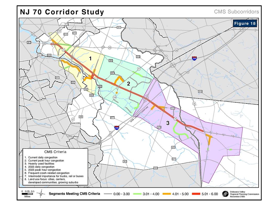
121
122 INSERT: Chapter 1 Title Page 1
123
124 8. CONCLUSIONS AND RECOMMENDATIONS Conclusions NJ 70 is plagued by three major corridor-wide problems that became recurring themes during the study effort: congestion, access, and accidents. Recurring peak period congestion has reduced traffic flow to stop and go conditions in several sections of the study area. This is common knowledge to regular users of the facility and was quantified in the NJDOT Route 70 CD Report. Accidents on NJ 70 are largely the byproduct of congestion and access related problems. Rear-end crashes are common on congested facilities, and are also common where travel lanes transition from 3 to 2, as motorists abruptly arrive on the heels of slower moving traffic. These three problems, congestion, access, and accidents, are most common in the parts of the corridor that have the highest retail concentrations and/or major roadway connections, i.e.: I-295. NJ 70 is divided by a grass median which limits access opportunities to signalized intersections and unsignalized median openings. Extra distance and time is added to almost every trip as drivers are forced to turn around via the nearest intersection in order to access the opposite direction of NJ 70. As a result, signalized intersections experience higher demand causing them to be overburdened. To supplement these access points, unsignalized median openings are provided, but only within the four lane cross sections of the facility. The openings are narrow and typically allow only two cars to queue before crossing into the stream of oncoming traffic either to make a u-turn, or enter a driveway. Congestion, combined with limited access, results in cut through traffic motorists by-pass traffic congestion from long waits at signals by using neighborhood streets as short cuts. Recommendations The implementation chapter of this report includes two matrices: 1) a location specific improvements matrix, and 2) a crash cluster location matrix. These two tables provide an appropriate starting point for addressing the transportation, traffic, and safety problems of the NJ 70 corridor. Both matrices are prioritized according to need so that implementation plans can be tailored accordingly. It is recommended that the problems identified in the Barclay Farm/Kingston Estates area be addressed first due to the breakdown of roadway operations on NJ 70, combined with the intense retail and residential landscape at this location. This location requires an innovative approach that balances the access needs of the local residential community with mobility and improved operations on NJ
125 Problems identified that involve low cost improvements (signs, striping) can be included as quick fix items in a larger, longer term implementation plan. The NJDOT maintenance division may be able to address some of these improvements without further study. The second highest crash cluster location* along the corridor is in the vicinity of NJ 70 and Old Cuthbert Boulevard. There were 83 westbound crashes (22 eastbound) and 71 rear end collision types. The data clearly shows the crash problem to be a westbound issue. NJ 70 westbound at this location experiences congestion due to the I-295 ramps. *The highest crash cluster location is at the Marlton Circle (NJ 70 and NJ 73), which is currently being addressed by NJDOT. 113
126 INSERT: Chapter 1 Title Page 1
127
128 9. IMPLEMENTATION The NJ 70 Corridor Study can be used as a tool for the systematic selection of transportation improvement projects. This section is intended to serve as a punch list for the government agencies having a stake in the implementation of improvements. Also included is a matrix of crash cluster locations. These follow a priority ranking system different from that used in Table 15 that is described in the key of the table. Because a more detailed analysis is necessary for identifying appropriate improvements, Center, Cost Range, and Benefits categories are not included in this table. Characteristics In choosing which projects should advance, stakeholders can be guided by the information presented in the NJ 70 Corridor Transportation Improvements Implementation Matrix (see Tables 15 and 16). This easy to use matrix suggests the relative importance of each problem location. The potential improvement scenarios are evaluated against the following criteria: State Development and Redevelopment Plan (SDRP) center designation, project priority, relative cost range, and project benefits. In addition, the stakeholders necessary to carry out the plan are also identified. State Development and Redevelopment Plan (SDRP) Centers The concept of centers is the organizing planning principle for achieving a more effective and efficient pattern of development in New Jersey. Under the state plan, new growth and development should be organized into compact development in the form of centers surrounded by carefully controlled "environs" by way of municipal master plans and regulations, and through public investment policy. Specifically, the SDRP defines center as " central places within planning areas where growth either should be attracted or not attracted, depending upon the unique characteristics and growth opportunities of each center". The Plan identifies five types of Centers: 1) Urban Centers; 2) Towns; 3) Regional Centers; 4) Villages; and 5) Hamlets and designates specific locales as centers. In the NJ 70 corridor there are no two designated centers. Priority There are three categories of priorities: high, moderate, and low. Priorities are assigned based on the type and severity of problem presented to motorists or other users of the system. Although safety issues usually receive the highest priority, other conditions such as congestion (time delay) and mobility are also considered. A higher degree of priority is assigned if there is an urgency to complete the improvement due to the 116
129 anticipated completion of a nearby major investment (development or transportation improvement). If there is concern that a section of right-of-way needed to complete an improvement is in danger of being developed or used for another use, the priority to act on that improvement is also heightened. If a project is relatively small scale and low cost, yet offers a projected high benefit, it may also receive a higher priority ranking. Cost Range Relative project costs are described as high, moderate, or low. High cost projects ($5 to 35$ million, or more) usually involve a major commitment from one or more funding source, lengthy public involvement, and require several years lead time in programming the required funds. They are typically large scale, complex, or multi-phased improvements usually involving new facilities. An improvement estimated to have a moderate cost (between $2 and $5 million) could involve reconstruction of an intersection, construction of a short connector road, or a widening of an existing road. Low cost projects (less than $2 million) often involve operational type improvements at isolated locations can often be fast-tracked by maintenance departments. These cost ranges are general estimates and could be significantly changed due to design criteria or to environmental, right-of-way, or other issues. Benefits The assigned benefit of the project refers to the type of improvement expected, such as: safety enhancements, congestion mitigation, mobility improvements, or economic development. The location and magnitude of the improvement determines the extent of the benefits received. Roles of Agencies In terms of a hierarchy of agencies, the New Jersey Department of Transportation (NJDOT) is primary, both in terms of maintaining NJ 70 and providing much of the design, right-of-way, and construction funding for major improvements. Municipalities make land use decisions in the corridor, which ultimately affects travel and traffic in the corridor. New Jersey Department of Transportation NJDOT has jurisdiction over the state highways in the corridor. In addition to NJ 70 these include: I-295, NJ 41, NJ 38, and NJ 73. Improvements to these highways are typically financed by state and/or federal funds. The state coordinates with the county and municipalities on what improvements are made to these facilities. Camden and Burlington Counties The county has jurisdiction over a network of roads throughout the study area. In New Jersey, county roads are given 500, 600 or 700 route designations. The 500 series of county roads are typically part of a statewide network of interconnected county routes; therefore 500 series routes are generally more significant than the other county roads. The primary function of the county network is to serve medium range trips or to serve as feeder routes to the state system. 117
130 Metropolitan Planning Organization (MPO) DVRPC, serving as the MPO for this region, is required to coordinate a comprehensive and continuing transportation planning process. This process results in the development of a Transportation Improvement Program (TIP) which identifies all priority projects for which federal funds will be sought. The TIP represents a consensus among state and regional officials as to which regional improvements are to be made. In addition to the TIP, the MPO is required by federal legislation to develop a long rang plan (LRP) to help direct region-wide transportation decision making over a period of at least 20 years. Long range plans do not specify the design of actual projects. Rather, they identify future needs to address transportation deficiencies. NJDOT Pipeline Process The New Jersey Department Of Transportation s Project Development Process consists of four levels for implementing projects. Known as pipelines, they are used to categorize projects according to the level of planning, engineering, regulation, and design necessary for implementation. Projects in pipeline one involve the most steps: concept development, feasibility assessment, preliminary design, final design, and construction. Large scale projects involving right-of-way acquisition fall into this category. Projects in pipeline four usually involve little planning or engineering and can be accomplished through a maintenance contract. Typical pipeline four projects include lane striping, short stretches of new pavement, or the addition of signs or lighting. Municipalities Local governments have jurisdiction over their local road system and they control local land use decisions. Decisions made at the local level can influence the travel on roads at all levels. Therefore, local officials must understand the traffic impacts which could be generated from a particular development and understand the synergy that exists between land use decisions and transportation improvements. Local officials need to be involved in the transportation planning process to assist in the problem definition and to make improvement recommendations. Ideally, municipal officials utilize the circulation element of their municipal master plan to balance transportation priorities and quality of life issues. 118
131 TABLE 15 IMPROVEMENTS IMPLEMENTATION MATRIX - LOCATION SPECIFIC TRANSPORTATION PROBLEMS # Location (west to east) Mile Post Municipality Priority Center 1 NJ 70 Cuthbert Boulevard / Executive Campus 1.12 Cherry Hill L NA L 2 NJ 70 Cornell Avenue Jug Handle 1.60 Cherry Hill L NA L Cost Range Benefits Lead Role Assisting Role NJDOT Pipeline SAFE, MOB DOT MCD 4 SAFE, MOB DOT MCD 4 3 Atlantic City Rail Line Bridge Over NJ Cherry Hill L NA L MOB CC MCD 4 4 Sayre Avenue Jug Handle 1.95 Cherry Hill M NA L CON, MOB DOT MCD 4 5 Garden State Park Redevelopment 2.07 Cherry Hill H NA M CON, MOB DOT MCD 3 6 CR 644 Haddonfield Wynwood Avenue 2.31 Cherry Hill M NA M SAFE CC MCD 3 7 Cooper Landing Road Median Opening 2.92 Cherry Hill H NA H SAFE, MOB DOT MCD 2 8 NJ Georgia / Edison Avenues 3.00 Cherry Hill M NA M SAFE, MOB DOT MCD 3 9 NJ Kingson Road / West Gate Drive 4.30 Cherry Hill H NA M / H CON, MOB DOT MCD 1 CON, 10 NJ Covered Bridge Road / Frontage Road 4.81 Cherry Hill H NA M / H MOB DOT MCD 1 11 Greentree Road / Springdale Road / Marlkress Road Jug Handle Cherry Hill H NA M SAFE, MOB DOT MCD 4 12 Industrial Complex Traffic on Springdale / Greentree Roads NA Cherry Hill M NA M / H CON, MOB MCD MCD 1 13 Birchwood Park Drive 6.61 Cherry Hill L NA M SAFE, MOB DOT MCD 4 14 NJ Cropwell Road 7.67 Evesham L NA M CON, MOB DOT MCD 3 15 Inappropriate Use of Shoulders On NJ Evesham L NA L SAFE, MOB DOT MCD 4 KEY Priority: H = High; M = Moderate; L = Low Center: C = State Development and Redevelopment Plan designated center/corridor Cost Range: H = High; M = Moderate; L = Low Benefits: CON = Congestion; MOB = Mobility; SAFE = Safety Role: MCD = Municipality; CC = Camden County; DOT = NJ Department of Transportation NJDOT Pipeline 1 = Concept Development, Feasibility Assessment, Preliminary Design, Final Design, Construction 2 = Scope Development, Feasibility Assessment, Preliminary Design, Final Design, Construction 3 = Environmental Documentation, Final Design, Construction 4 = Maintenance Contract 119
132 TABLE 16 IMPROVEMENTS IMPLEMENTATION MATRIX - CRASH CLUSTER LOCATIONS # Nearest Cross Street or Driveway Municipality Mile Post Range Total Crashes Predominant Type (#) Predominant Direction (#) Priority Lead Role Assisting Role 1 CR 612 Browning Road (NJ 70 EB), NJ 70 WB at NJ 38. Pennsauken Rear End (27) East (26) L NJDOT CC 2 NJ 70 and McClellan Avenue (signalized) Pennsauken Rear End (24) West (21) L NJDOT MCD 3 CR 636 Cuthbert Boulevard at NJ 70 (interchange) Cherry Hill Rear End (13) West (19) L NJDOT CC 4 Cornell Avenue at NJ 70 (signalized) Cherry Hill Rear End (37) West (32) M NJDOT MCD 5 CR 644 Haddonfield Road at NJ 70 (signalized) Cherry Hill Rear End (41) West (33) M NJDOT CC 6 CR 627 Cooper Landing Road at NJ 70 (median opening) Cherry Hill Rear End (40) West (34) M NJDOT CC 7 Maine Avenue and Vermont Road at NJ 70 (median opening) Cherry Hill Rear End (25) West (31) M NJDOT MCD 8 NJ 41 Kings Highway at NJ 70 (signalized) Cherry Hill Rear End (48) East (42) H NJDOT CC 9 East of Sawmill Road and NJ 70 (two median openings) Cherry Hill Rear End (24) East (29) L NJDOT MCD 10 East of Kingston Road and NJ 70 (signalized, median openings) Cherry Hill Rear End (38) West (31) M NJDOT MCD 11 East Gate Drive at NJ 70 (unsignalized, median openings) Cherry Hill Rear End (58) West (46) H NJDOT MCD 12 Covered Bridge Road/Frontage Road at NJ 70 (signalized) Cherry Hill Rear End (27) East (26) L NJDOT MCD 13 I-295 at NJ 70 (interchange) Cherry Hill Rear End (38) West (56) M NJDOT MCD 14 Old Cuthbert Road at NJ 70 (unsignalized) Cherry Hill Rear End (71) West (83) H NJDOT MCD 15 East of Astoria Boulevard at NJ 70 (unsignalized) Cherry Hill Rear End (17) East (13) L NJDOT MCD 16 CR 672 Marlkress Road at NJ 70 (signalized) Cherry Hill Angle (22) East (23) M NJDOT CC 17 CR 674 Greentree Road at NJ 70 (signalized) Cherry Hill Rear End (48) West (38) H NJDOT CC 18 East of CR 673 Springdale Road at NJ 70 (signalized) Cherry Hill Rear End (37) East (29) M NJDOT CC 19 Vicinity of Old Orchard Road at NJ 70 (signalized T-intersection) Cherry Hill Rear End (54) East (44) H NJDOT MCD 20 Conestoga Drive at NJ 70 (unsignalized) Evesham Rear End (21) East (13) L NJDOT BC 21 Cropwell Road at NJ 70 (unsignalized) Evesham Rear End (27) East (23) M NJDOT BC 22 NJ 73 at NJ 70, Marlton Circle (signalized) Evesham Sideswipe (99) West (101) H NJDOT MCD KEY Priority: H (High) = 3 X THRESHOLD OF 24; M (Moderate) = 2 X 24; L (LOW) = Role: MCD = Municipality; CC = Camden County; BC = Burlington County; DOT = NJ Department of Transportation 120


133
134 INSERT: Chapter 1 Title Page 1
135 BIBLIOGRAPHY 1. New Jersey Department of Transportation. NJ 70 Concept Development Report. October National Cooperative Highway Research Program. Report 524 Safety of U-Turns at Unsignalized Median Openings American Association of State Highway Transportation Officials. A Policy on Geometric Design of Highways and Streets, Fifth Edition Delaware Valley Regional Planning Commission Long Range Transportation Plan. 1995
136 INSERT: Chapter 1 Title Page 1

137
138 INSERT: Chapter 1 Title Page 1
139 APPENDIX A Municipal Representatives, Coordinating Agency Representatives
140 INSERT: Chapter 1 Title Page 1
141 Municipal Representatives Sgt Dale Matchett, Traffic Officer, Police Department, Cherry Hill Township Dave Benedetti, Director, Community Development, Cherry Hill Township Nicole Hostettler, Senior Planner, Cherry Hill Township Todd Okilchany, Zoning Board Administrator, Cherry Hill Township Steve Musilli, Director of Engineering, Cherry Hill Township Lt. Tim Gasparovich, Police Department, Haddonfield Borough Sgt. Tew, Traffic Officer, Police Department, Evesham Township Terri Bracchi, Department of Community Activities, Evesham Township Coordinating Agency Representatives Jody Barankin, Project Planning and Development, New Jersey Department Of Transportation Patricia Feliciano, New Jersey Department Of Transportation, Office of Community Relations Jim Yeager, Michael Baker & Associates Amy Sokalski, Michael Baker & Associates Alan Maiman, New Jersey Transit
142 INSERT: Chapter 1 Title Page 1
143 APPENDIX B Needs Inventory
144 INSERT: Chapter 1 Title Page 1
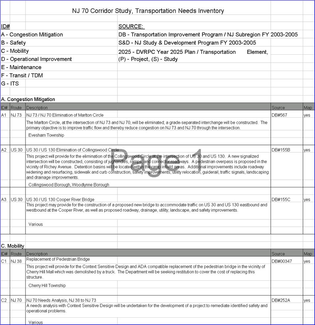
145

146
147 APPENDIX C Crash Data Straight Line Diagrams
148 INSERT: Chapter 1 Title Page 1

149
150 NJ Crash Clusters by Mile Post # of Crashes MP DELAWARE VALLEY REGIONAL PLANNING COMMISSION OCTOBER 2005 Source Data: NJDOT 4 MILES Legend Unsignalized Median Opening # of Crashes in Catchment Area (aprix..10 mile) Interstate Route NJ Route County Road Grade Separated Interchange Road Underpass Road Overpass # GATE 4 (2.07) DELAWARE AVE (2.12) BEIDEMAN AVE (2.18) WASHINGTON AVE 644 HADDONFIELD RD (2.31) GROVE ST 644 (2.36) MERCER ST FULTON ST (2.49) CHAMBERS ST (2.56) (2.63) WARREN AVE CURTIS AVE (2.66) TO LOCUST (2.70) WOOD PARK (2.89) CONWELL AVE (2.83) WHITMAN AVE (2.77) WEBSTER AVE (2.72) COOPER LANDING (2.92) ROAD SHERIDAN AVE GRANT AVE (2.95) (3.00) GEORGIA AVE EDISON AVE (3.19) CONNECTICUT AVE (3.13) VIRGINIA AVENUE (3.07) WESLEY AVE (3.12) COOPER AVE NEW HAMPSHIRE AVE (3.31) (3.29) HARDING AVE RHODE ISLAND AVE (3.25) (3.23) HARRISON AVE MASSACHUSETTS AVE (3.18) MADISON AVE Cherry Hill Twp, Camden Co (3.38) VERMONT RD PARK RD (3.44) MAINE AVE BOUNDERY LN (3.47) KINGS HWY (3.66) 41 BRACE RD 154 Cherry Hill Twp, Camden Co KENWOOD DR (3.79) (3.90) BROOKMEAD DR (3.99) CROPWELLS BK. SAWMILL RD (4.09) MILES Street Name John Davison Rockefeller Memorial Hwy Jurisdiction N.J.D.O.T. Functional Class Urban Principal Arterial Speed Limit 45 Number of Lanes SB/WB Shou SB/WB Pave Divided Med. Type Med. Width Unprotected 24 VAR Undiv. NB/EB Pave. NB/EB Shou Traffic Volume 52,220 (91) 51,339 (03) 48,830 (91)
151 NJ Crash Clusters by Mile Post # of Crashes MP DELAWARE VALLEY REGIONAL PLANNING COMMISSION OCTOBER Source Data: NJDOT MILES Legend Unsignalized Median Opening # of Crashes in Catchment Area (aprx..10 miles) Interstate Route NJ Route County Road Grade Separated Interchange Road Underpass Road Overpass # KINGSTON RD (4.30) W GATE RD RANALDO TERR (4.53) BARK LAKE TERR (4.47) E GATE DR (4.63) PINE VALLEY RD (4.76) FRONTAGE RD (4.81) COVERED BRIDGE RD 295 (5.07) OLD CUTHBERT RD (5.29) FRONTAGE RD (5.33) NEW JERSEY TURNPIKE ASTORIA BLVD (5.42) MARLKRESS (5.60) ROCKHILL AVE (5.54) ROAD FAIRFAX AVE (5.67) ROAD (5.75) GREENTREE 674 WEIDO LA (5.95) Cherry Hill Twp, Camden Co 673 SPRINGDALE- (6.10) Cherry Hill Twp, Camden Co FELLOWSHIP RD MILES Street Name Jurisdiction Functional Class Speed Limit 5.0 John Davison Rockefeller Memorial Hwy N.J.D.O.T. Urban Principal Arterial Number of Lanes SB/WB Shou SB/WB Pave Divided Med. Type Med. Width Unprotected VAR Undiv. NB/EB Pave. NB/EB Shou Traffic Volume 55,398 (03)
152 NJ Crash Clusters by Mile Post # of Crashes MP DELAWARE VALLEY REGIONAL PLANNING COMMISSION OCTOBER 2005 Source Data: NJDOT 4 3 MILES Legend Unsignalized Median Opening # of Crashes in Catchment Area (aprx..10 miles) Interstate Route NJ Route County Road Grade Separated Interchange Road Underpass Road Overpass # COBBLE CREEK CIR (6.52) BIRCHWOOD RD (6.61) WEXFORD DR OLD ORCHARD RD (6.94) SPLIT ROCK DR (7.22) OLD MARLTON PIKE (7.34) TO CONESTOGA ( 7.34) 620 (7.40) CONESTOGA DR (7.37) PENNSAUKEN CK. Evesham Twp, Burlington Co CROPWELL (7.67) ROAD Evesham Twp, Burlington Co TO SHOPPING CTR (8.01) 73 (8.33) 73 MILES Street Name John Davison Rockefeller Memorial Hwy Jurisdiction N.J.D.O.T. Functional Class Urban Principal Arterial Speed Limit Number of Lanes 4 SB/WB Shou Divided Undiv. SB/WB Pave. Med. Type Med. Width NB/EB Pave. NB/EB Shou. Traffic Volume Unprotected VAR ,260 (91) 43,380 (92) 40,640 (92) 30,240 (91) 37,747 (03)
153 TRIB. TO COOPER RIV. NJ Median Opening Crash Frequency by Mile Post # of Crashes MP DELAWARE VALLEY REGIONAL PLANNING COMMISSION OCTOBER 2005 Source Data: NJDOT 4 MILES Legend Unsignalized Median Opening # of Crashes in Catchment Area (aprx. 210 feet) Interstate Route NJ Route County Road Grade Separated Interchange Road Underpass Road Overpass MILES # (0.00) BROWNING RD (0.04) 612 Pennsauken Twp, Camden Co SINKINSON AVE (0.22) (0.35) MCCLELLEN AVE (0.35) CHANDLERS RUN MANSION BLVD (0.50) Pennsauken Twp, Camden Co (0.66) LEXINGTON AVENUE (0.66) (0.63) HAMPTON RD (0.85) DONAHUE AVE (0.90) CUTHBERT (1.04) BOULEVARD (1.10) Cherry Hill Twp, Camden Co HARVARD (1.37) AVENUE DELEWARE AVE (1.47) (1.42) UNION AVENUE Cherry Hill Twp, Camden Co (1.53) CORNELL AVENUE (1.84) CR R.R. TO TRACK (1.92) SAYER AVE (1.95) (2.00) PENN AVE GATE 4 (2.07) DELAWARE AVE Street Name Jurisdiction Functional Class John Davison Rockefeller Memorial Hwy N.J.D.O.T. Urban Principal Arterial Divided Speed Limit 45 Begin NJ 70 MP=0.00 Number of Lanes 6 SB/WB Shou. 0 SB/WB Pave. 36 Med. Type Unprotected Med. Width 24 Undiv. NB/EB Pave. 36 NB/EB Shou. 0 Traffic Volume 10,800 (94) 45,775 (03) 59,365 (03)
154 NJ Median Opening Crash Frequency by Mile Post # of Crashes MP DELAWARE VALLEY REGIONAL PLANNING COMMISSION OCTOBER Source Data: NJDOT MILES Legend Unsignalized Median Opening # of Crashes in Catchment Area (aprix. 210 feet) Interstate Route NJ Route County Road Grade Separated Interchange Road Underpass Road Overpass # GATE 4 (2.07) DELAWARE AVE (2.12) BEIDEMAN AVE (2.18) WASHINGTON AVE 644 HADDONFIELD RD (2.31) GROVE ST 644 (2.36) MERCER ST FULTON ST (2.49) CHAMBERS ST (2.56) (2.63) WARREN AVE CURTIS AVE (2.66) TO LOCUST (2.70) WOOD PARK (2.89) CONWELL AVE (2.83) WHITMAN AVE (2.77) WEBSTER AVE (2.72) COOPER LANDING (2.92) ROAD SHERIDAN AVE GRANT AVE (2.95) (3.00) GEORGIA AVE EDISON AVE (3.19) CONNECTICUT AVE (3.13) VIRGINIA AVENUE (3.07) WESLEY AVE (3.12) COOPER AVE NEW HAMPSHIRE AVE (3.31) (3.29) HARDING AVE RHODE ISLAND AVE (3.25) (3.23) HARRISON AVE MASSACHUSETTS AVE (3.18) MADISON AVE Cherry Hill Twp, Camden Co (3.38) VERMONT RD PARK RD (3.44) MAINE AVE BOUNDERY LN (3.47) KINGS HWY (3.66) 41 BRACE RD 154 Cherry Hill Twp, Camden Co KENWOOD DR (3.79) (3.90) BROOKMEAD DR (3.99) CROPWELLS BK. SAWMILL RD (4.09) MILES Street Name John Davison Rockefeller Memorial Hwy Jurisdiction N.J.D.O.T. Functional Class Urban Principal Arterial Speed Limit 45 Number of Lanes SB/WB Shou SB/WB Pave Divided Med. Type Med. Width Unprotected 24 VAR Undiv. NB/EB Pave. NB/EB Shou Traffic Volume 52,220 (91) 51,339 (03) 48,830 (91)
155 59 65 * total crashes N J Median Opening Crash Frequency by Mile Post # of Crashes MP DELAWARE VALLEY REGIONAL PLANNING COMMISSION OCTOBER 2005 Source Data: NJDOT 4 4 MILES Legend Unsignalized Median Opening # of Crashes in Catchment Area (aprx. 210 feet) Interstate Route NJ Route County Road Grade Separated Interchange Road Underpass Road Overpass # KINGSTON RD (4.30) W GATE RD RANALDO TERR (4.53) BARK LAKE TERR (4.47) E GATE DR (4.63) PINE VALLEY RD (4.76) FRONTAGE RD (4.81) COVERED BRIDGE RD 295 (5.07) OLD CUTHBERT RD (5.29) FRONTAGE RD (5.33) NEW JERSEY TURNPIKE ASTORIA BLVD (5.42) MARLKRESS (5.60) ROCKHILL AVE (5.54) ROAD FAIRFAX AVE (5.67) ROAD (5.75) GREENTREE 674 WEIDO LA (5.95) Cherry Hill Twp, Camden Co 673 SPRINGDALE- (6.10) Cherry Hill Twp, Camden Co FELLOWSHIP RD MILES Street Name Jurisdiction Functional Class Speed Limit 5.0 John Davison Rockefeller Memorial Hwy N.J.D.O.T. Urban Principal Arterial Number of Lanes SB/WB Shou SB/WB Pave Divided Med. Type Med. Width Unprotected VAR Undiv. NB/EB Pave. NB/EB Shou Traffic Volume 55,398 (03)
156 N J * total crashes Median Opening Crash Frequency by Mile Post # of Crashes MP DELAWARE VALLEY REGIONAL PLANNING COMMISSION OCTOBER 2005 Source Data: NJDOT MILES Legend Unsignalized Median Opening # of Crashes in Catchment Area (aprx. 210 feet) Interstate Route NJ Route County Road Grade Separated Interchange Road Underpass Road Overpass # COBBLE CREEK CIR (6.52) BIRCHWOOD RD (6.61) WEXFORD DR OLD ORCHARD RD (6.94) SPLIT ROCK DR (7.22) OLD MARLTON PIKE (7.34) TO CONESTOGA ( 7.34) 620 (7.40) CONESTOGA DR (7.37) PENNSAUKEN CK. Evesham Twp, Burlington Co CROPWELL (7.67) ROAD Evesham Twp, Burlington Co TO SHOPPING CTR (8.01) 73 (8.33) 73 MILES Street Name John Davison Rockefeller Memorial Hwy Jurisdiction N.J.D.O.T. Functional Class Urban Principal Arterial Speed Limit Number of Lanes 4 Divided Undiv. SB/WB Shou. SB/WB Pave. Med. Type Med. Width NB/EB Pave. NB/EB Shou. Traffic Volume Unprotected VAR ,260 (91) 43,380 (92) 40,640 (92) 30,240 (91) 37,747 (03)
157 APPENDIX D Median Opening Diagrams
158 INSERT: Chapter 1 Title Page 1
159
160
161
162 INSERT: Chapter 1 Title Page 1
163 APPENDIX E Environmental Screening
164 INSERT: Chapter 1 Title Page 1
165 ENVIRONMENTAL SCREENING Introduction A top level screening has been conducted to determine the occurrence of potentially environmentally sensitive sites along the NJ 70 Corridor. The areas of interest are Wetlands/ Open Space, Potential Hazardous Waste Sites, Threatened and/or Endangered Species, and Historic Sites /Community Facilities. Wetlands/ Open Space The Map: Wetlands, & Open Space was compiled using data from the US Fish and Wildlife Service, New Jersey Office of State Planning and the Delaware Valley Regional Planning Commission s Open Space Inventory. Wetlands, flood prone areas, county and municipal open space data were examined and mapped to identify any areas of concern. In the study area, the wetland and flood prone areas are mainly associated with three main bodies of water in the study area: Cooper River; North Branch Cooper River and the Pennsauken Creek. While there are no wetland areas that are immediately adjacent to NJ 70, there are four locations that fall within the flood prone areas. The areas are located at the nexus of NJ 70 and NJ 38, in the vicinity of Cuthbert Boulevard, near Park Drive, near St. Andrew s Church, and between Mimosa Road and Conestoga Road at the border of Cherry Hill Township and Evesham Township. Potential Hazardous Waste Sites New Jersey Department of Environmental Protection s (NJ DEP) database of known contaminated sites was queried to determine if any of these sites were present in the study area. The Known Contaminated Sites List for New Jersey are those sites and properties where contamination of soil or ground water has been identified or where there has been, or there is suspected to have been, a discharge of contamination. Table X lists the known sites which fall within the study area and rated high based on a level of site complexity. These sites are graphically represented on the Map: Known Contaminated Sites. This list may include sites where remediation either is currently under way, required but not yet initiated or has been completed. Additionally new contaminated sites have been identified since the creation of this list and are not included here. For a complete list of all Known Contaminates Sites, regardless of severity, please refer to the Appendix. For further information contact NJDEP's Site Remediation Programs (SRP) lead program, which are identified with each site listed in the table. Additional environmental sources were also examined to determine the existence of other potentially hazardous or contaminated sites. Sites from the Comprehensive Environmental Response, Compensation, and Liability Information System (CERCLIS) database were examined. These sites are the US Environmental Protection Agency s 1
166 (US EPA) Superfund Sites and the program is administered in cooperation with the individual states. The National Priorities List (NPL) of national priorities among the known releases or threatened releases of hazardous substances, pollutants, or contaminants throughout the United States and its territories was also reviewed. Although there are a few occurrences within the municipalities associated with the study, the sites are located outside of the NJ 70 study area boundaries. must be considered when identifying any potential roadway improvements in the area. These features are graphically represented on the Map: Community Facilities. A detailed list of the community facilities is located in the appendix. Table XX provides a listing of all sites that are listed in the New Jersey and National Registers of Historic Places, NJDEP - Historic Preservation Office. None of the ten historic sites are located on or adjacent to NJ 70. Threatened and/or Endangered Species The New Jersey Department of Environmental Protection (NJDEP) Natural Heritage Program performed a database search of their Natural Heritage Database and the Landscape Project habitat mapping for occurrences of any rare wildlife species, habitat, rare plants or natural communities that are in the NJ 70 study area. The databases show no record of any rare plant, animals, or habitat located within a 1/4 mile of the study area. The Natural Heritage Program has provided a list of rare species and natural communities that have been documented from Camden and Burlington Counties. If there is a suitable habitat at a particular project site, then these species may have the potential to be present. This list is located in the Appendix. Historic Sites /Community Facilities A top level screening has been conducted to determine the occurrence of potentially environmentally sensitive sites. Cultural features such as historic sites, schools, and churches have been identified within the NJ 70 Corridor. These features 2
167 NJ 70 Corridor Study Environmental Screening - Community Facilities Type NAME ADDRESS CITY COUNTY STATE School A. Russell Knight Elementary School Old Carriage Rd Cherry Hill Camden NJ School Barclay School 1200 Winston Way Cherry Hill Camden NJ School Cherry Hill High-East High School Kresson Rd Cherry Hill Camden NJ School Henry C. Beck Middle School Cropwell Rd Cherry Hill Camden NJ School James Johnson Elementary School Kresson Rd Cherry Hill Camden NJ School Kingston Elementary School Kingston Rd Cherry Hill Camden NJ School Richard Stockton Elementary School Wexford Drive Cherry Hill Camden NJ School Rosa International Middle School 485 Browning Lane Cherry Hill Camden NJ School J. Fithian Tatem Elementary School One Glover Avenue Haddonfield Camden NJ Place of Worship Saint Stephens Church 6306 Browning Road Pennsauken Camden NJ Place of Worship Bethel Church 1704 Springdale Road Cherry Hill Camden NJ Place of Worship Hillman Church Cherry Hill Camden NJ Place of Worship Immaculate Conception Novitiate Cherry Hill Camden NJ Place of Worship Queen of Heaven Church 700 Marlton Pike West Cherry Hill Camden NJ Place of Worship Saint Andrews Church 327 Marlton Pike West Cherry Hill Camden NJ Place of Worship Catholic Church of Saint Mary's 2001 Springdale Road Cherry Hill Camden NJ Place of Worship Saint Marys Church Cherry Hill Camden NJ Place of Worship Saint Michaels Church 601 Kings Highway North Cherry Hill Camden NJ Place of Worship Saint Pius X Church 344 Kresson Road Cherry Hill Camden NJ Place of Worship Temple Emanuel 1101 Springdale Road Cherry Hill Camden NJ Place of Worship Trinity Church 499 Route 70 East Cherry Hill Camden NJ Place of Worship Woodland Church Cherry Hill Camden NJ Place of Worship Mount Olivet Church 206 Douglass Avenue Haddonfield Camden NJ Cemetery Calvary Cemetery 2398 Marlton Pike West Cherry Hill Camden NJ Cemetery Locustwood Cemetery Route 70 Cherry Hill Camden NJ Historic Barclay Farmstead 209 Barclay Lane Cherry Hill Camden NJ Historic Bonnie's Waylond Road over Sawmill Creek Cherry Hill Camden NJ Historic Samuel Coles House 1743 Old Cuthbert Road Cherry Hill Camden NJ Cooper River (between Kaighn Ave and Walworth Lake) Pennsauken, Cherry Hill, Haddonfield Camden NJ Historic Cooper River Park Historic District Historic Kay-Evans Farmstead 100 Borton Mill Road Cherry Hill Camden NJ Historic Haddon Fortnightly Clubhouse 301 East King's Highway Haddonfield Camden NJ Historic Greenfield Hall (Third Methodist Church) 343 East King's Highway Haddonfield Camden NJ Historic Samuel Mickle House 345 East King's Highway Haddonfield Camden NJ Historic Lullworth Hall 435 East King's Highway Haddonfield Camden NJ Historic Cropwell Friends Meeting House 801 Cropwell Road Evesham Burlington NJ 3
168
169 Table X NJ Department of Environmental Protection Site Remediation Program Known Contaminated Sites (2001) DVRPC MAP ID SITE_ID NAME ADDRESS CITY COUNTY STATUS LEAD REMEDIAL_L STATUS_DT XYORIGIN X_COORD Y_COORD x NJL KSM FASTENING SYSTEMS INCORPORATED 301 NEW ALBANY RD Moorestown Township Burlington Active BEECRA D :00:00 MAP x NJD SUBURBAN PAVING 100 CUTHBERT BLVD Audubon Borough Camden Active BCM C :00:00 MAP x NJL CONCORD CHEMICAL COMPANY INCORPORATED 17TH & MICKLE STS Camden City Camden Active BEECRA C :00:00 MAP x NJD CHERRY HILL ERLTON LANDFILL 920 MCGILL AVE Cherry Hill Township Camden Pending BFO-CA C :00:00 MAP x NJL HADDON HEIGHTS BOROUGH SANITARY LANDFILL DEVON AVE & I 295 Haddon Heights Borough Camden Pending BFO-CA C :00:00 MAP x NJL HADDONFIELD BOROUGH SANITARY LANDFILL ATLANTIC AVE Haddonfield Borough Camden Pending BFO-CA C :00:00 MAP x NJD MAPLE SHADE TOWNSHIP LANDFILL 501 RTE 73 Maple Shade Township Burlington Pending BFO-CA C :00:00 MAP x NJL BEL AIR MOTOR LODGE RTE 73 & WILLOW RD Maple Shade Township Burlington Pending BFO-CA C :00:00 MAP NJD ROCHESTER INCORPORATED 7027 KAIGHN AVE Pennsauken Township Camden Pending BUST C :00:00 MAP NJD DISMAR CORPORATION 4415 MARLTON PK Pennsauken Township Camden Active BUST C :00:00 MAP NJL LIFE SUPPORT AMBULANCE 5050 CENTRAL HWY Pennsauken Township Camden Active BFO-S C :00:00 MAP NJP HESS SERVICE STATION RTE 38 W Pennsauken Township Camden Active BUST C :00:00 MAP NJL GOODWILL INDUSTRY INCORPORATED 5421 RTE 70 (MARLTON PK) Pennsauken Township Camden NFA BUST C :00:00 ADDMATCH NJD MCDONNELL DOUGLAS TRUCK SERVICES 2374 MARLTON PK W Cherry Hill Township Camden Active BUST C :00:00 MAP NJL HARMONSON BROTHERS INCORPORATED 908 NORTHWOOD AVE Cherry Hill Township Camden NFA-A BFO-S C :00:00 MAP NJL DELCREST MEDICAL PRODUCTS & SERVICE CO 800 RTE 38 Cherry Hill Township Camden Active BUST C :00:00 MAP NJL SW ELECTRONICS & MANUFACTURING CORP 619 HOLLYWOOD AVE Cherry Hill Township Camden Active BEECRA C :00:00 ADDMATCH NJD MOBIL SERVICE STATION RTE 38 & CHAPEL AVE Cherry Hill Township Camden Active BUST C :00:00 MAP NJD ATOMIC TIRE & AUTO SERVICE COMPANY 408 HADDONFIELD RD Cherry Hill Township Camden Active BUST C :00:00 MAP NJL CITGO SERVICE STATION RTE 38 & MALL DR Cherry Hill Township Camden Active BUST C :00:00 MAP NJD MOBIL SERVICE STATION 500 HADDONFIELD RD Cherry Hill Township Camden Active BUST C :00:00 MAP NJL SERVICE STATION 2025 RTE 70 & WASHINGTON AVE Cherry Hill Township Camden Active BUST C :00:00 MAP NJD EXXON SERVICE STATION RTE 70 & MARLKRESS RD Cherry Hill Township Camden Active BUST C :00:00 MAP NJL LOCUSTWOOD CEMETERY ASSOCIATION RTE 70 W Cherry Hill Township Camden Active BUST C :00:00 MAP NJP MOBIL SERVICE STATION RTE 70 & GEORGIA AVE Cherry Hill Township Camden Active BUST C :00:00 MAP NJL BEECHWOOD AVE 330 BEECHWOOD AVE Haddonfield Borough Camden Active BFO-S C :00:00 ADDMATCH NJL WELLINGTON AVENUE 427 WELLINGTON AVE Haddonfield Borough Camden Active BFO-S C :00:00 ADDMATCH NJL ELLISBURG SHOPPING CENTER 1590 KINGS HWY & RTE 70 Cherry Hill Township Camden Pending BUST C :00:00 MAP NJD EXXON SERVICE STATION RTE 70 & ELLISBURG CIR Cherry Hill Township Camden Active BUST C :00:00 MAP NJL GREEN NURSERY ELLISBURG CIR & BRACE RD Cherry Hill Township Camden Active BUST C :00:00 DIFF NJL CITGO SERVICE STATION RTE 70 & KINGSTON RD Cherry Hill Township Camden Active BUST C :00:00 MAP NJL RANOLDO TERRACE 36 RANOLDO TERR Cherry Hill Township Camden Active BFO-S C :00:00 ADDMATCH NJL CASINO LIMOUSINE SERVICE 615 CHAPEL AVE E Cherry Hill Township Camden Pending BUST C :00:00 MAP NJD INFOTRON SYSTEMS CORPORATION 9 OLNEY AVE NORTH Cherry Hill Township Camden Active BEECRA C :00:00 MAP NJD CHERRY HILL INDUSTRIAL CENTER 20 OLNEY AVE Cherry Hill Township Camden Active BEECRA C :00:00 MAP NJL EXXON SERVICE STATION 1701 MARLTON PK Cherry Hill Township Camden NFA-A BUST C :00:00 MAP NJL SUNOCO SERVICE STATION RTE 70 & GRAYDON AVE Cherry Hill Township Camden Active BUST C :00:00 MAP NJD ARAMARK SERVICES INCORPORATED 1178 MARLKRESS RD Cherry Hill Township Camden Active BUST C :00:00 MAP
170 Table X NJ Department of Environmental Protection Site Remediation Program Known Contaminated Sites (2001) DVRPC MAP ID SITE_ID NAME ADDRESS CITY COUNTY STATUS LEAD REMEDIAL_L STATUS_DT XYORIGIN X_COORD Y_COORD 31 NJD EXXON SERVICE STATION RTE 70 & SPRINGDALE RD Cherry Hill Township Camden Active BUST C :00:00 MAP NJD EXXON SERVICE STATION RTE 70 & MARLTON PK Evesham Township Burlington Active BUST C :00:00 MAP NJD SUNOCO SERVICE STATION 930 RTE 70 & MARLTON PK Evesham Township Burlington Active BUST C :00:00 MAP NJL FORMER MOBIL FACILITY #LX6 RTE 70 & CROPWELL RD Evesham Township Burlington Active BUST C :00:00 ADDMATCH NJD BURNS HONDA 500 RTE 70 W Evesham Township Burlington NFA BUST C :00:00 MAP NJD SUNOCO SERVICE STATION RTE 73 & BAKER BLVD Evesham Township Burlington Active BUST C :00:00 MAP NJL DOWNING STREET 16 DOWNING ST Cherry Hill Township Camden Active BFO-S C :00:00 ADDMATCH NJD TEXACO SERVICE STATION RTE 73 & MAPLE AVE Evesham Township Burlington Active BUST C :00:00 MAP NJD GOODYEAR AUTO SERVICE CENTER 1108 RTE 70 (MARLTON PK) Cherry Hill Township Camden Pending BFO-S C :00:00 MAP NJD NJ DEPARTMENT OF TRANSPORTATION RTE 70 & OLD CUTHBERT RD Cherry Hill Township Camden Active BFO-S C :00:00 MAP NJL GARDEN STATE RACE TRACK RTE 70 & HADDONFIELD RD Cherry Hill Township Camden Active BFO-S C :00:00 MAP NJL BRIND LILY TRUCK LEASING 2374 RTE 70 Cherry Hill Township Camden Active BFO-IN C :00:00 MAP NJL COOPER RUN DR 34 COOPER RUN DR Cherry Hill Township Camden Active CEHA C :00:00 ADDMATCH NJL LAUREL TERRACE 10 LAUREL TERR Cherry Hill Township Camden Active CEHA C :00:00 ADDMATCH NJL WOODLAND AVE 405 WOODLAND AVE Cherry Hill Township Camden Active CEHA C :00:00 ADDMATCH NJL SNOWDEN PLACE 7 SNOWDEN PL Cherry Hill Township Camden Active CEHA C :00:00 ADDMATCH NJL COOPER RUN 15 COOPER RUN Cherry Hill Township Camden Active CEHA C :00:00 ADDMATCH NJL SHERIDAN AVE 66 SHERIDAN AVE Cherry Hill Township Camden Active BFO-S C :00:00 ADDMATCH NJL SHERRY WAY 407 SHERRY WAY Cherry Hill Township Camden Active BFO-S C :00:00 ADDMATCH NJL LONGWOOD AVE 629 LONGWOOD AVE Cherry Hill Township Camden Active CEHA C :00:00 ADDMATCH NJL HOLTZ PROPERTY 125 N CROPWELL RD Evesham Township Burlington Active BFO-S C :00:00 ADDMATCH NJL GROVE STREET 412 GROVE ST Haddonfield Borough Camden Active BFO-S C :00:00 ADDMATCH NJD MOBIL SERVICE STATION RTES 70 & 295 Cherry Hill Township Camden Active BUST B :00:00 MAP NJL MARLTON PIKE PRECISION COMPANY BEECHWOOD AVE & OLIVE ST Cherry Hill Township Camden Pending BFO-S B :00:00 MAP NJL ACCU PRINTS INCORPORATED 2076 E MARLTON PK Cherry Hill Township Camden Active BFO-IN B :00:00 MAP NJL GANDALF SYSTEMS CORPORATION 9N OLNEY AVE Cherry Hill Township Camden Active BEECRA B :00:00 MAP NJL OLD SHARP SCHOOL MARLKRESS RD Cherry Hill Township Camden Active BFO-IN B :00:00 MAP NJL ARETT SALES CORPORATION 1152 MARLKRESS RD Cherry Hill Township Camden Active BFO-IN B :00:00 ADDMATCH NJD SHELL SERVICE STATION RTES 70 & 73 (MARLTON CIRCLE) Evesham Township Burlington Active BFO-S B :00:00 MAP NJL AMOCO SERVICE STATION RTE 70 & CONESTOGA DR Evesham Township Burlington Active BUST B :00:00 MAP NJL GULF SERVICE STATION RTES 70 & 73 Evesham Township Burlington Active BUST B :00:00 GPS NJL OLNEY AVENUE NORTH 4 OLNEY AVE N Cherry Hill Township Camden Active BUST :00:00 MAP NJL MOBIL SERVICE STATION 1501 RTE 38 Cherry Hill Township Camden Active BUST :00:00 MAP NJL TEXACO SERVICE STATION 1390 RTE 70 E Cherry Hill Township Camden Active BUST :00:00 DIFF NJL CHERRY HILL REPAIR 1516 RTE 38 Cherry Hill Township Camden Active BUST :00:00 MAP NJL WEIDO LA 9 WEIDO LA Cherry Hill Township Camden Active BFO-S :00:00 MAP NJL MARLTON SQUARE SHOPPING CENTER 701 TO 735 RTE 70 W Evesham Township Burlington Active BFO-S :00:00 MAP NJL EXXON SERVICE STATION RTE 73 & 70 CIR Evesham Township Burlington NFA-A BUST :00:00 MAP NJL MARLTON SPECIALITY SHOPS 300 RTE 73 S Evesham Township Burlington Active BUST :00:00 MAP NJL J & J SNACK FOODS 6000 CENTRAL HWY Pennsauken Township Camden Active BFO-IN :00:00 MAP This table was developed using New Jersey Department of Environmental Protection Site Remediation Program s data but this secondary product has not been verified by NJ DEP and is not state authorized.

171

172
DVRPC CMP Strategies by Subcorridor
 NJ CMP Corridor 1 DVRPC CMP Strategies by Subcorridor See map for each corridor and its subcorridors Corridor ID Corridor Name Corridor Notes 1 I-295, NJ Turnpike (N) New Jersey Turnpike from I-276 merge
Route 7 Corridor Study
 Route 7 Corridor Study Executive Summary Study Area The following report analyzes a segment of the Virginia State Route 7 corridor. The corridor study area, spanning over 5 miles in length, is a multi
US 30 CORRIDOR STUDY NJ 73 to Atlantic County Border Camden County. Delaware Valley Regional Planning Commission September 2006
 US 30 CORRIDOR STUDY NJ 73 to Atlantic County Border Camden County Delaware Valley Regional Planning Commission September 2006 Created in 1965, the Delaware Valley Regional Planning Commission (DVRPC)
CHAPTER 4: IDENTIFICATION OF ROAD SYSTEM DEFICIENCIES: TRANSPORTATION PLANNING MODEL
 CHAPTER 4: IDENTIFICATION OF ROAD SYSTEM DEFICIENCIES: TRANSPORTATION PLANNING MODEL I. INTRODUCTION Transportation planning models are the primary tools used to predict future travel conditions. With
Regional Transportation Needs Within Southeastern Wisconsin
 Regional Transportation Needs Within Southeastern Wisconsin #118274 May 24, 2006 1 Introduction The Southeastern Wisconsin Regional Planning Commission (SEWRPC) is the official areawide planning agency
Exhibit 1 PLANNING COMMISSION AGENDA ITEM
 Exhibit 1 PLANNING COMMISSION AGENDA ITEM Project Name: Grand Junction Circulation Plan Grand Junction Complete Streets Policy Applicant: City of Grand Junction Representative: David Thornton Address:
City of Wayzata Comprehensive Plan 2030 Transportation Chapter: Appendix A
 A1. Functional Classification Table A-1 illustrates the Metropolitan Council s detailed criteria established for the functional classification of roadways within the Twin Cities Metropolitan Area. Table
ROUTES 55 / 42 / 676 BUS RAPID TRANSIT LOCALLY PREFERRED ALTERNATIVE
 ROUTES 55 / 42 / 676 BUS RAPID TRANSIT LOCALLY PREFERRED ALTERNATIVE April, 2012 1 INTRODUCTION The need for transit service improvements in the Routes 42/55/676 corridor was identified during the Southern
City of Homewood Transportation Plan
 City of Homewood Transportation Plan Prepared for: City of Homewood, Alabama Prepared by: Skipper Consulting, Inc. May 2007 TABLE OF CONTENTS INTRODUCTION... 1 BACKGROUND INFORMATION... 1 EXISTING TRANSPORTATION
ADOT Statewide Bicycle and Pedestrian Program Summary of Phase IV Activities APPENDIX B PEDESTRIAN DEMAND INDEX
 ADOT Statewide Bicycle and Pedestrian Program Summary of Activities APPENDIX B PEDESTRIAN DEMAND INDEX May 24, 2009 Pedestrian Demand Index for State Highway Facilities Revised: May 29, 2007 Introduction
TRAFFIC IMPACT ANALYSIS
 TRAFFIC IMPACT ANALYSIS FOR THE CHAMPAIGN UNIT#4 SCHOOL DISTRICT PROPOSED HIGH SCHOOL (SPALDING PARK SITE) IN THE CITY OF CHAMPAIGN Final Report Champaign Urbana Urbanized Area Transportation Study 6/24/2014
4. ENVIRONMENTAL IMPACT ANALYSIS 9. TRANSPORTATION AND TRAFFIC
 4. ENVIRONMENTAL IMPACT ANALYSIS 9. TRANSPORTATION AND TRAFFIC 4.9.1 INTRODUCTION The following section addresses the Proposed Project s impact on transportation and traffic based on the Traffic Study
Overview. Existing Conditions. Corridor Description. Assessment
 Overview A study of the 23 rd Street corridor was undertaken to document the existing conditions, analyze traffic operations, and recommend remedies for deficient situations Although 23 rd Street is frequently
FY 2018 TRANSPORTATION CAPITAL PROGRAM New Jersey Department of Transportation Projects
 Camden County Bus Purchase Project ID Numbers: D0601 / 068082 In the DVRPC region, a combination of fixed route, subscription, and demand responsive transit services are provided in Camden County by Senior
DVRPC staff would like to acknowledge the assistance of the steering committee for this study.
 The Delaware Valley Regional Planning Commission is dedicated to uniting the region s elected officials, planning professionals, and the public with a common vision of making a great region even greater.
Project Kickoff Meeting February 15, 2018
 Project Kickoff Meeting February 15, 2018 Scope of Work: Study Area Project Goals Develop traffic calming alternatives to the Vine Street local right of way, to mitigate speeding. Develop concept plans
Welcome and Introductions Overview of the Study to Date Community Involvement Intersection Improvement Concepts Bike-Ped Recommendations ITS
 Welcome and Introductions Overview of the Study to Date Community Involvement Intersection Improvement Concepts Bike-Ped Recommendations ITS Recommendations Transit Recommendations Next Steps Inventoried
Chapter 4 Traffic Analysis
 Chapter 4 Traffic Analysis PURPOSE The traffic analysis component of the K-68 Corridor Management Plan incorporates information on the existing transportation network, such as traffic volumes and intersection
5.0 Roadway System Plan
 Southwest Boise Transportation Study Page 16 5.0 Roadway System Plan The Roadway System Plan outlines roadway improvements in the Initial Study Area. It forecasts future deficiencies on the arterial system,
APPENDIX G: INTERSECTION NEEDS AT OKEECHOBEE BOULEVARD
 APPENDIX G: INTERSECTION NEEDS AT OKEECHOBEE BOULEVARD INTERSECTION NEEDS AT SR 7 and OKEECHOBEE BOULEVARD SR 7 Extension Project Development and Environment (PD&E) Study From Okeechobee Boulevard (SR
6.0 PEDESTRIAN AND BICYCLE FACILITIES 6.1 INTRODUCTION 6.2 BICYCLE DEMAND AND SUITABILITY Bicycle Demand
 6.0 PEDESTRIAN AND BICYCLE FACILITIES 6.1 INTRODUCTION Bicycle and pedestrian travel along and in the vicinity of the corridor is part of the vision of Somerset and Hunterdon counties and the integrated
South Jersey certainly has many of quality of life issues related to transportation. In spite of being a small state, the Garden State has the 3 rd
 This presentation summarizes an on-going study of commuter rail potential in Southern New Jersey. This study examines the 3 rail alignments that have been proposed by the Delaware River Port Authority
THE I-79 CORRIDOR. I-79 provides motorists with connections to the following major highways: I-80, PA 358, PA 965 and PA 208.
 The I-79 Corridor Pittsburgh to Erie Regional Thruway I-79 was constructed through Mercer County in the early 1960s. The portion north of PA 965 opened in 1961 and the segment south of PA 965 the following
I-105 Corridor Sustainability Study (CSS)
") I-105 Corridor Sustainability Study (CSS) Metro Streets and Freeways Subcommittee March 21, 2019 Gary Hamrick Cambridge Systematics, Inc. I-105 CSS Project History & Background Funded by Caltrans Sustainable
I-105 Corridor Sustainability Study (CSS) Metro Streets and Freeways Subcommittee March 21, 2019 Gary Hamrick Cambridge Systematics, Inc. I-105 CSS Project History & Background Funded by Caltrans Sustainable
Executive Summary Route 30 Corridor Master Plan
 Route Corridor Master Plan Project Overview The Route Corridor Master Plan is a coordinated multimodal transportation and land use plan for the entire stretch of Route through East Whiteland Township,
Highway 49, Highway 351 and Highway 91 Improvements Feasibility Study Craighead County
 Highway 49, Highway 351 and Highway 91 Improvements Feasibility Study Craighead County Executive Summary March 2015 Highway 49, Highway 351 and Highway 91 Improvements Feasibility Study Craighead County
Clackamas County Comprehensive Plan
 ROADWAYS The County s road system permits the movement of goods and people between communities and regions, using any of a variety of modes of travel. Roads provide access to virtually all property. They
1999 On-Board Sacramento Regional Transit District Survey
 SACOG-00-009 1999 On-Board Sacramento Regional Transit District Survey June 2000 Sacramento Area Council of Governments 1999 On-Board Sacramento Regional Transit District Survey June 2000 Table of Contents
Proposed. City of Grand Junction Complete Streets Policy. Exhibit 10
 Proposed City of Grand Junction Complete Streets Policy Exhibit 10 1 City of Grand Junction Complete Streets Policy Vision: The Complete Streets Vision is to develop a safe, efficient, and reliable travel
Bikeway action plan. Bicycle Friendly Community Workshop March 5, 2007 Rochester, MN
 Bikeway action plan Summary The was held on March 5, 2007 at the Rochester Mayo Civic Center. The workshop was hosted by Rochester-Olmsted County Planning Department in collaboration with the League of
Appendix C. NORTH METRO STATION AREA TRAFFIC IMPACT STATEMENT 88th Avenue Station
 Appendix C NORTH METRO STATION AREA TRAFFIC IMPACT STATEMENT 88th Avenue Station Prepared for: Regional Transportation Department and URS Corporation as part of the North Metro EIS David Evans and Associates,
SANTA CLARA COUNTYWIDE BICYCLE PLAN August 2008
 SANTA CLARA COUNTYWIDE BICYCLE PLAN August 2008 To assist VTA and Member Agencies in the planning, development and programming of bicycle improvements in Santa Clara County. Vision Statement To establish,
Defining Purpose and Need
 Advanced Design Flexibility Pilot Workshop Session 4 Jack Broz, PE, HR Green May 5-6, 2010 Defining Purpose and Need In your agency s project development process, when do design engineers typically get
3.0 Future Conditions
 3.0 Future Conditions In order to be able to recommend appropriate improvements to the transportation system of the Town, it is important to first understand the nature and volume of traffic that is expected
Highway 217 Corridor Study. Phase I Overview Report
 Highway 217 Corridor Study Phase I Overview Report November 3, 24 BACKGROUND AND OVERVIEW Study purpose The Highway 217 Corridor Study is developing multi-modal transportation solutions for traffic problems
JONESBORO HIGHWAY 63 HIGHWAY 18 CONNECTOR STUDY
 JONESBORO HIGHWAY 63 HIGHWAY 18 CONNECTOR STUDY Craighead County May 2007 JONESBORO HIGHWAY 63 HIGHWAY 18 CONNECTOR STUDY Craighead County May 2007 Prepared by Planning and Research Division Arkansas State
MCTC 2018 RTP SCS and Madera County RIFP Multi-Modal Project Eval Criteria GV13.xlsx
 MCTC 8 RTP SCS and Madera County RIFP Multi-Modal Project Eval Criteria GV.xlsx Madera County Transportation Commission Regional Transportation Plan / Sustainable Communities Strategy Multi-Modal Project
CITY OF COCOA BEACH 2025 COMPREHENSIVE PLAN. Section VIII Mobility Element Goals, Objectives, and Policies
 CITY OF COCOA BEACH 2025 COMPREHENSIVE PLAN Section VIII Mobility Element Goals, Objectives, and Policies Adopted August 6, 2015 by Ordinance No. 1591 VIII MOBILITY ELEMENT Table of Contents Page Number
BICYCLE FACILITIES INVENTORY: SUMMARY REPORT
 BICYCLE FACILITIES INVENTORY: SUMMARY REPORT Southern New Jersey September 2008 2002 D Lincoln Drive West Marlton, NJ 08053 (856) 596-8228 www.driveless.com BICYCLE FACILITIES INVENTORY SUMMARY REPORT
Circulation in Elk Grove includes: Motor vehicles, including cars and trucks
 Circulation, as it is used in this General Plan, refers to the many ways people and goods move from place to place in Elk Grove and the region. Circulation in Elk Grove includes: Motor vehicles, including
Solana Beach Comprehensive Active Transportation Strategy (CATS)
") Solana Beach Comprehensive Active Transportation Strategy (CATS) 3.0 Goals & Policies The Solana Beach CATS goals and objectives outlined below were largely drawn from the Solana Beach Circulation Element
Solana Beach Comprehensive Active Transportation Strategy (CATS) 3.0 Goals & Policies The Solana Beach CATS goals and objectives outlined below were largely drawn from the Solana Beach Circulation Element
Regional Bicycle Barriers Study
 Regional Bicycle Barriers Study Executive Summary Background and Purpose The 2040 Transportation Policy Plan (TPP) sets policies for planning and investment direction in the transportation system in the
SECTION 1 - TRAFFIC PLANNING
 SECTION 1 - TRAFFIC PLANNING 1.1 TRAFFIC OPERATIONS 1.1.1 Roadway Functional Classification The Multnomah County Comprehensive Framework Plan s Policy 34: Trafficways and the Functional Classification
Transportation Corridor Studies: Summary of Recommendations
 Transportation Corridor Studies: Summary of Recommendations Route 4 Corridor Study: Route 10 Corridor Study: Route 44 Corridor Study: Route 175 Corridor Study: Route 5/15 Corridor Study: Rentschler Field
Magnolia Place. Traffic Impact Analysis. Prepared for: City of San Mateo. Prepared by: Hexagon Transportation Consultants, Inc.
 Magnolia Place Traffic Impact Analysis Prepared for: City of San Mateo Prepared by: Hexagon Transportation Consultants, Inc. Updated January 4, 2010 Table of Contents 1. Introduction...1 2. Existing Conditions...6
Purpose and Need. Chapter Introduction. 2.2 Project Purpose and Need Project Purpose Project Need
 Chapter 2 Purpose and Need 2.1 Introduction The El Camino Real Bus Rapid Transit (BRT) Project (Project) would make transit and other transportation improvements along a 17.6-mile segment of the El Camino
4 DISRUPTION MANAGEMENT PLAN HIGHWAY 7 RAPIDWAY CONSTRUCTION BETWEEN BAYVIEW AVENUE AND WARDEN AVENUE TOWNS OF MARKHAM AND RICHMOND HILL
 4 DISRUPTION MANAGEMENT PLAN HIGHWAY 7 RAPIDWAY CONSTRUCTION BETWEEN BAYVIEW AVENUE AND WARDEN AVENUE TOWNS OF MARKHAM AND RICHMOND HILL The Transportation Services Committee recommends the adoption of
APPENDIX E: Transportation Technical Report
 New Jersey Pennsylvania Lackawanna Cut-Off Passenger Rail Service Reston Project Environmental Assessment APPENDIX E: Transportation Technical Report E.1 Introduction As part of the overall environmental
Executive Summary June 2015
 Executive Summary June 2015 Highway 112 Corridor Study Benton and Washington Counties Executive Summary June 2015 Prepared by Transportation Planning and Policy Division Arkansas State Highway and Transportation
Mobility and Congestion
 Technical Memorandum Mobility and Congestion Prepared for: Prepared by: September 25, 2013 1 Table of Contents 1. Introduction... 1 2. Congestion Forecasting Process... 1 2.1 Mobility and Congestion Terms...
Central Jersey Transportation Forum. March 2007
 Central Jersey Transportation Forum March 2007 Feasibility Analysis of BRT on Dinky Right of Way from Princeton Station to Alexander Rd. in West Windsor (west of Rt. 1) Study spurred by Princeton University's
City of Novi Non-Motorized Master Plan 2011 Executive Summary
 City of Novi Non-Motorized Master Plan 2011 Executive Summary Prepared by: February 28, 2011 Why Plan? Encouraging healthy, active lifestyles through pathway and sidewalk connectivity has been a focus
Traffic Technical Environmental Study
 Traffic Technical Environmental Study US Department of Transportation Federal Highway Administration New Jersey Department of Transportation Table of Contents I. Introduction Project Background. 1 Purpose
EXECUTIVE SUMMARY OF CALEDON TRANSPORTATION NEEDS STUDY
 EXECUTIVE SUMMARY OF CALEDON TRANSPORTATION NEEDS STUDY The Caledon Transportation Needs Study has been undertaken as a joint project by the Town of Caledon and the Region of Peel to determine the existing
o n - m o t o r i z e d transportation is an overlooked element that can greatly enhance the overall quality of life for the community s residents.
 N o n - m o t o r i z e d transportation is an overlooked element that can greatly enhance the overall quality of life for the community s residents. 84 Transportation CHAPTER 11 INTRODUCTION Transportation
Multimodal Through Corridors and Placemaking Corridors
 68 Multimodal Through Corridors and Placemaking Corridors Corridors have different functions in a region. Some corridors are used to get smoothly and rapidly through a region or to get quickly to major
INNER LOOP EAST. AIA Rochester Annual Meeting November 13, 2013 TRANSFORMATION PROJECT. Bret Garwood, NBD Erik Frisch, DES
 INNER LOOP EAST TRANSFORMATION PROJECT AIA Rochester Annual Meeting November 13, 2013 Bret Garwood, NBD Erik Frisch, DES Why? We are building a city that encourages walking, biking and enjoying the outdoor
APPENDIX F SUPPLEMENTAL TRAFFIC DATA
 APPENDIX F SUPPLEMENTAL TRAFFIC DATA Environmental and Planning Consultants 440 Park Avenue South 7th Floor New York, NY 10016 tel: 212 696-0670 fax: 212 213-3191 www.akrf.com Draft Memorandum To: Michael
University Hill Transportation Study Technical Memorandum Alternatives Modeling and Analysis May 2007
 Technical Memorandum May 2007 Syracuse Metropolitan Transportation Council Edwards and Kelcey with Wallace Roberts and Todd Alta Planning and Design CONTENTS SECTION ONE- INTRODUCTION...1 SECTION TWO-
US 130 NJ TURNPIKE AREA INFRASTRUCTURE NEEDS ANALYSIS
 US 130 NJ TURNPIKE AREA INFRASTRUCTURE NEEDS ANALYSIS DELAWARE VALLEY REGIONAL PLANNING COMMISSION JUNE 2001 861-7XUQSLNH$UHD,QIUDVWUXFWXUH 1HHGV$QDO\VLV June, 2001 DELAWARE VALLEY REGIONAL PLANNING COMMISSION
Highway 111 Corridor Study
 Highway 111 Corridor Study June, 2009 LINCOLN CO. HWY 111 CORRIDOR STUDY Draft Study Tea, South Dakota Prepared for City of Tea Sioux Falls Metropolitan Planning Organization Prepared by HDR Engineering,
RESOLUTION NO ?? A RESOLUTION OF THE CITY OF NEPTUNE BEACH ADOPTING A COMPLETE STREETS POLICY
 RESOLUTION NO. 2018-?? A RESOLUTION OF THE CITY OF NEPTUNE BEACH ADOPTING A COMPLETE STREETS POLICY WHEREAS, safe, convenient, and accessible transportation for all users is a priority of the City of Neptune
Rochester Area Bike Sharing Program Study
 roc bike share Rochester Area Bike Sharing Program Study Executive Summary ~ January 2015 JANUARY 2015 8484 Georgia Avenue, Suite 800 Silver Spring, MD 20910 3495 Winton Pl., Bldg E, Suite 110 Rochester,
ACTIVE TRANSPORTATION
 ACTIVE TRANSPORTATION Mobility 2040 Supported Goals Improve the availability of transportation options for people and goods. Support travel efficiency measures and system enhancements targeted at congestion
Complete Street Analysis of a Road Diet: Orange Grove Boulevard, Pasadena, CA
 Complete Street Analysis of a Road Diet: Orange Grove Boulevard, Pasadena, CA Aaron Elias, Bill Cisco Abstract As part of evaluating the feasibility of a road diet on Orange Grove Boulevard in Pasadena,
PEDESTRIAN ACTION PLAN
 ATTACHMENT 2 CITY OF SANTA MONICA PEDESTRIAN ACTION PLAN CITY OF SANTA MONICA PEDESTRIAN ACTION PLAN This page intentionally left blank EXECUTIVE SUMMARY CHAPTER 1 EXECUTIVE SUMMARY Setting the Stage
Bridge Street Corridor Study Report
 Bridge Street Corridor Study Report Prepared for: Prepared by: BRIDGE STREET CORRIDOR STUDY REPORT PREPARED FOR: CITY OF ARROYO GRANDE COMMUNITY DEVELOPMENT DEPARTMENT 300 EAST BRANCH STREET ARROYO GRANDE,
MoPac South: Impact on Cesar Chavez Street and the Downtown Network
 MoPac South: Impact on Cesar Chavez Street and the Downtown Network Prepared by: The University of Texas at Austin Center for Transportation Research Prepared for: Central Texas Regional Mobility Authority
Gwinnett County Department of Transportation SR 324 / Gravel Springs Road at I-85 / SR 403 Interchange Project Number F , PI No.
 June 4, 2015 Dear Resident: Thank you for attending this public information meeting for the proposed SR 324 / Gravel Springs Road at I-85 Interchange. The purpose of this meeting is two-fold: to provide
Traffic Impact Study. Westlake Elementary School Westlake, Ohio. TMS Engineers, Inc. June 5, 2017
 TMS Engineers, Inc. Traffic Impact Study Westlake Elementary School Westlake, Ohio June 5, 2017 Prepared for: Westlake City Schools - Board of Education 27200 Hilliard Boulevard Westlake, OH 44145 TRAFFIC
# Southeastern Wisconsin Regional Freeway System Reconstruction Study and Preliminary Recommended Plan
 #70421 Southeastern Wisconsin Regional Freeway System Reconstruction Study and Preliminary Recommended Plan Public Information Meetings and Hearings May June 2002 1 Reason for Freeway System Study 270-mile
EUCLID AVENUE PARKING STUDY CITY OF SYRACUSE, ONONDAGA COUNTY, NEW YORK
 EUCLID AVENUE PARKING STUDY CITY OF SYRACUSE, ONONDAGA COUNTY, NEW YORK CITY OF SYRACUSE DEPARTMENT OF PUBLIC WORKS 1200 CANAL STREET EXTENSION SYRACUSE, NEW YORK 13210 DRAFT REPORT DATE: November 13,
Appendix A-1: Purpose and Need Statement
 Appendix A-1: Purpose and Need Statement PURPOSE AND NEED STATEMENT Western & Ashland Corridors Bus Rapid Transit (BRT) Project Prepared for Chicago Transit Authority 567 West Lake Street Chicago, IL 60661
MOUNTAIN HOUSE SPECIFIC PLAN I 9.1 INTRODUCTION ASSUMPTIONS TRANSPORTATION FACILITIES TRANSPORTATION IMPROVEMENTS PHASING 9.
 CHAPTER NINE: TRANSPORTATION AND CIRCULATION 9.1 INTRODUCTION 9.1 9.2 ASSUMPTIONS 9.1 9.3 TRANSPORTATION FACILITIES 9.1 9.4 TRANSPORTATION IMPROVEMENTS PHASING 9.3 LIST OF FIGURES LIST OF TABLES Figure
METHODOLOGY. Signalized Intersection Average Control Delay (sec/veh)
") Chapter 5 Traffic Analysis 5.1 SUMMARY US /West 6 th Street assumes a unique role in the Lawrence Douglas County transportation system. This principal arterial street currently conveys commuter traffic
Chapter 5 Traffic Analysis 5.1 SUMMARY US /West 6 th Street assumes a unique role in the Lawrence Douglas County transportation system. This principal arterial street currently conveys commuter traffic
A Matter of Fairness: ROCOG s Environmental Justice Protocol. What is Mobility Limitation?
 No Person Left Behind What is Mobility Limitation? What is the Access Limitation? Environmental Justice population should be provided adequate mobility & access to meet their needs; Identify acceptable
CONNECTING PEOPLE TO PLACES
 CONNECTING PEOPLE TO PLACES 82 EAST BENCH MASTER PLAN 07 Introduction The East Bench transportation system is a collection of slow moving, treelined residential streets and major arteries that are the
DRAFT BUENA VISTA 2020 TRANSPORTATION PLAN
 DRAFT BUENA VISTA 2020 TRANSPORTATION PLAN DEVELOPED BY THE TRANSPORTATION PLANNING DIVISION OF THE VIRGINIA DEPARTMENT OF TRANSPORTATION IN COOPERATION WITH THE U.S. DEPARTMENT OF TRANSPORTATION, FEDERAL
Appendix T 1: Additional Supporting Data
 Appendix T 1: Additional Supporting Data Project Delivery Delays with the implementation of the 2000 TIP became apparent early in the decade. In response to direction among policy officials, ARC began
Focused Traffic Analysis for the 200 Nellen Avenue Project
 March 13, 2017 Mr. Phil Boyle Town of Corte Madera 300 Tamalpais Drive Corte Madera, CA 94976-0159 Focused Traffic Analysis for the 200 Nellen Avenue Project Dear Mr. Boyle; W-Trans has completed a focused
APPENDIX 2 LAKESHORE ROAD TRANSPORTATION REVIEW STUDY EXECUTIVE SUMMARY
 APPENDIX 2 LAKESHORE ROAD TRANSPORTATION REVIEW STUDY EXECUTIVE SUMMARY Appendix 2 City of Mississauga Lakeshore Road FINAL REPORT Transportation Review Study December 2010 EXECUTIVE SUMMARY Study Purpose
Pocatello Regional Transit Master Transit Plan Draft Recommendations
 Pocatello Regional Transit Master Transit Plan Draft Recommendations Presentation Outline 1. 2. 3. 4. What is the Master Transit Plan? An overview of the study Where Are We Today? Key take-aways from existing
Transportation Improvements for the Church Road (CR 616) Corridor
 Corridor") Transportation Improvements for the Church Road (CR 616) Corridor AUGUST 2014 The Delaware Valley Regional Planning Commission is dedicated to uniting the region s elected officials, planning professionals,
Transportation Improvements for the Church Road (CR 616) Corridor AUGUST 2014 The Delaware Valley Regional Planning Commission is dedicated to uniting the region s elected officials, planning professionals,
Roundabout Feasibility Memorandum
 Roundabout Feasibility Memorandum To From Gwen Pipkin Bill Howell Date June 18, 2013 Subject Roundabout Feasibility Study SR 29 PD&E Study From Oil Well Road to SR 82 Collier County, FL FPID 417540-1-22-01
Develop a Multi-Modal Transportation Strategy (Theme 6)
") DEVELOP A MULTI-MODAL TRANSPORTATION STRATEGY (THEME 6) WHY IS THIS THEME ADDRESSED? Develop a Multi-Modal Transportation Strategy (Theme 6) Statement of Ideal Reduce resident and visitor reliance on single
DEVELOP A MULTI-MODAL TRANSPORTATION STRATEGY (THEME 6) WHY IS THIS THEME ADDRESSED? Develop a Multi-Modal Transportation Strategy (Theme 6) Statement of Ideal Reduce resident and visitor reliance on single
Appendix A-2: Screen 1 Alternatives Report
 Appendix A-2: Screen 1 Alternatives Report SCREEN 1 ALTERNATIVES REPORT Western & Ashland Corridors Bus Rapid Transit (BRT) Project Prepared for Chicago Transit Authority 567 West Lake Street Chicago,
APPENDIX H EXISTING TRAFFIC CONDITIONS ANALYSIS
 APPENDIX H EXISTING TRAFFIC CONDITIONS ANALYSIS MEMO : Peter Steacy, P.Eng. Date: December 3, 2014 : Ian Borsuk, P.Eng. Job No.: 3414015-000 Subject: City of Ottawa O-Train Extension Planning & EA Study
INTERMODAL TRANSPORTATION PLAN
 INTRODUCTION INTERMODAL TRANSPORTATION PLAN Effective intermodal transportation implies a public policy for actively decreasing the demand for automobile trips and consequently reducing automobile related
ECTS Purpose & Needs. Exhibit Home-Based Work Trips Attracted to the Penn/Jeannette Area
 Exhibit 4.23 - Home-Based Work Trips Attracted to the Penn/Jeannette Area Exhibit 4.24 - Transit Use for Work Trips Attracted to the Penn/Jeannette Area Eastern Corridor Transit Study 61 Greensburg - and
Travel and Rider Characteristics for Metrobus
 Travel and Rider Characteristics for Metrobus 040829040.15 Travel and Rider Characteristics for Metrobus: 2012-2015 Overview The Miami Dade County Metropolitan Planning Organization (MPO) conducted a series
Congestion Management Report
 Congestion Management Report F.E. EVERETT TURNPIKE (NORTH), MERRIMACK Segment Length: 7.0 miles Daily Traffic Volumes: 60,000-69,000 Analysis Period: May 2015 Number of Traffic Signals: 0 Number of travel
Sixth Line Development - Transit Facilities Plan
 Memorandum Date: November 13, 2012 To: From: c.c. Subject: Rob Freeman (Freeman Planning) Kevin Phillips Sixth Line Development - Transit Facilities Plan 33016631 This memo was prepared to review the transit
Chapter 5 Future Transportation
 Chapter 5 Future Transportation The Future Land Use Plan identifies the desired land use designations. The land uses desired for Crozet depend, in large part, on the success of the transportation system,
Henderson Avenue Mixed-Use Development
 Zoning Case: Z145-3 Traffic Impact Analysis Henderson Avenue Mixed-Use Development Dallas, TX October 26 th, 216 Kimley-Horn and Associates, Inc. Dallas, Texas Project #644827 Registered Firm F-928 Traffic
Project Report. South Kirkwood Road Traffic Study. Meadows Place, TX October 9, 2015
 Meadows Place, TX October 9, 2015 Contents 1 Introduction... 1 2 Data Collection... 1 3 Existing Roadway Network... 2 4 Traffic Volume Development... 2 5 Warrant Analysis... 3 6 Traffic Control Alternative
TRAFFIC ASSESSMENT River Edge Colorado
 TRAFFIC ASSESSMENT River Edge Colorado Submitted by: Fehr & Peers 621 17th Street, Ste. 231 Denver, CO 8293 (33) 296-43 December, 21 App. M-2 Traffic Assessment River Edge Colorado December 21 TABLE OF
Burlington County Bicycle Level of Service Study
 Burlington County Bicycle Level of Service Study June 2013 The Delaware Valley Regional Planning Commission is dedicated to uniting the region s elected officials, planning professionals, and the public
Chapter 6 Transportation Plan
 Chapter 6 Transportation Plan Transportation Plan Introduction Chapter 6 Transportation Plan Transportation Plan Introduction This chapter describes the components of Arvada s transportation system, comprised
INTRODUCTION THOROUGHFARE SYSTEM CLASSIFICATIONS
 INTRODUCTION The thoroughfare plan will assist public officials in the development of a specialized system for efficient and safe movement of vehicular traffic while minimizing potential conflicts with
CHAPTER 7 CIRCULATION
 CHAPTER 7 CIRCULATION A township s transportation network links its population with the surrounding communities. Transportation networks, including public and private, provide the means by which township