Iowa Department of Natural Resources Iowa Water Trails Grant Program
|
|
|
- Ralph Holmes
- 5 years ago
- Views:
Transcription


1 Iowa Department of Natural Resources Iowa Water Trails Grant Program Submitted by the City of Story City in conjunction with the Skunk River Paddlers and the Story County Conservation Board Tuesday, January 31, 2006
2 IOWA WATER TRAILS PROGRAM GRANT APPLICATION Postmark Deadline: Last business day of January PROJECT NAME APPLICANT NAME CONTACT PERSON Skunk River Water Trail Modifications to Low-head Dam, Story City, Iowa City of Story City Carol Williams, Special Projects Ranger, Story County Conservation ADDRESS (street address required) th Street CITY Ames STATE Iowa ZIP CODE PHONE (day) PHONE (evening) TOTAL IOWA DNR WATER TRAILS & SAFETY GRANT AMOUNT REQUESTED $ 26,660 FUNDS SECURED FROM OTHER SOURCES $ 37,426 NRT grant $ 5,000 City of Ames $ 2,000 Mannatt s, Inc. $ 44,426 Total to Date FUNDS NEEDED FROM OTHER SOURCES $ 6,000 Kiosks (grant submitted) TOTAL COST OF PROJECT $ 77,086 TOTAL NUMBER OF TRAIL MILES TO BE CONSTRUCTED OR AFFECTED 28
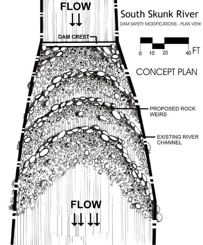
3 B. APPLICANTS The City of Story City is working closely with the Skunk River Paddlers and Story County Conservation on the Skunk River Water Trail project. C. NARRATIVE This project involves the conversion of an existing low-head dam to a rock rapids. Glacial field stones will be placed below the dam at Story City, tapering downstream at a 20:1 slope. A series of rock weirs will be formed to direct the main flow away from the stream banks, reducing bank erosion, creating stream habitat, and allowing for the safe passage of canoes and kayaks. Rock weirs have been constructed in Iowa and around the country to reduce bank erosion, prevent scouring of river and stream bottoms, and to restore balance to the hydrology of our altered waterways. Properly designed and constructed these weirs will reduce erosion, provide for sediment transport, enhance habitat for fish and other aquatic species, and provide for safe passage of paddlecraft while producing natural wave features for playboaters and whitewater enthusiasts. The Story City dam is the starting point of the Skunk River Water Trail and is situated in a scenic setting in Story City s South Park, just below a stone footbridge built in 1936 by the Work Projects Administration (WPA). Local residents are known to paddle above the dam, but passage over the existing sheet pile structure is rarely possible or advisable. It is hoped that this project will serve as a model for dangerous low-head dam conversions around the state. The South Skunk River from Story City to Ames has been promoted for canoeing and fishing by both the Story County Conservation Board and the Iowa Department of Natural Resources (IDNR) for many years. Story County Conservation has maintained canoe accesses along that section of the South Skunk River since the 1970 s. The Skunk River Paddlers received a National Recreational Trails grant in 2003 for the Skunk River Water Trail. Since then, the group has worked diligently to improve access to the Skunk River. During 2005, the paddlers made improvements to five areas utilizing over 300 volunteer hours. Additional funding was received from private sources in the form of contributions for food and drinks for workdays and donated equipment time. Recently a grant was submitted to the IDNR for additional funding for informational displays (kiosks) at each of the 11 accesses. The Skunk River water trail is being developed using IDNR Water Trail guidelines.

4 D. MAP OF PROJECT AREA Water Trail


5 D. MAP OF PROJECT AREA - STORY CITY

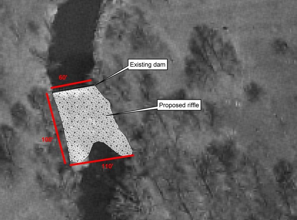
6 E. CROSS-SECTION OF THE PROJECT F. SKETCH PLAN OF THE PROJECT
7
8 G. ITEMIZED BREAKDOWN OF PROJECT COSTS 1) Field stone, 400 $65/ton, including purchase, transportation, backhoe arrangement downstream of dam, minimum bank protection/aesthetic rock at edges of sheet pile dam $26,000 2) Design/Engineering $2,160 Total $28,160 Amount in NRT grant for rock -$ 1,500 Total grant request $26,660 H. TIME SCHEDULE Summer/fall of 2006 pending approval of the joint application for PROTECTING IOWA WATERS which has been submitted to the Iowa Department of Natural Resources and U.S. Army Corps of Engineers. I. LETTER OF ENDORSEMENT
9
10 J. RESPONSES TO APPLICATION RANKING CRITERIA 1. Will this trail use the statewide water trail signage system? (Yes or no. If not, please explain.) Yes, with a few exceptions: Dam warning and portage signs pre-exist the state sign standards and some were installed as part of a National Recreational Trails (NRT) Grant. Water trail (logo) signs were also purchased prior to the DNR s Water Trail Program but have not yet been installed. NRT funds for kiosks, bridge signs, and landing signs have not yet been spent, and our intent is to use the new DNR standards. 2. How will this project enhance water safety on the trail s waterway? Proposed modifications to the Story City dam will eliminate the dangerous recirculating hydraulic associated with low-head dams and will allow for safe passage over the dam at most stream flows. Work projects completed in 2005, as part of the NRT Grant, have improved river access at six locations on the South Skunk in Story County. Re-shaping of the stream bank at the US Filter dam has provided for a more visible and safe portage route. All of these improvements will allow canoeists and kayakers easier put-in and take-out locations. Signs and informational kiosks will provide river and trail users with a better sense of location in the case of emergency. 3. Describe your water resource and how your water trail will be attractive to people seeking recreation experiences on it. The Skunk River has long been promoted by both Story County and the Iowa DNR as appropriate for canoeing and fishing. Much of the river corridor is zoned as greenbelt by Story County or designated as critical resource areas for their aesthetic, environmental, and recreational value. The river, greenbelt trails, and adjacent parklands are used by a diverse and varied group of people. However, prior to this project, several launch/landing areas were undeveloped, steep, and often muddy, limiting safe and frequent use by the general public. Improvements made under the NRT Grant address these barriers and create a more attractive and usable river access for all users. This project will improve existing river access between Story City and Ames and will establish three new access points to extend the trail an additional 10 miles. Improvements are to include signs, informational kiosks, and the renovation or development of 10 launch/landing areas. This project also provides for handicapped access at two points near Ames. With these improvements, the Skunk River Canoe Trail will meet Iowa Trails Plan 2000 guidelines for water trails. Coupled with the natural resources of the river, these improvements are expected to provide a better experience for canoeists and kayakers. 4. How does your water trail project correspond with conservation efforts, including but not limited to watershed improvement, conservation improvements, trash clean-ups, greenbelt enhancement, scenic view protection, and water quality monitoring? The Skunk River has been the focus of conservation and clean-up efforts from primarily Ames residents. Paddlers, other local groups, and individuals participate in the Story County Conservation Adopt-A-Park program. Several community groups, including the Skunk River Paddlers, Skunk River Navy, Squaw Creek Watershed Coalition, and the ISU Soil and Water Conservation Club, organize and participate in stream monitoring (IOWATER) and clean-ups on the Skunk and its tributaries. The improved launch/landing areas will facilitate removal of trash from the river during these clean-up events. All of these supporters share an interest in recreational opportunities and a concern for the river, watershed, and natural areas within. Further enhancements to the Skunk River Water Trail will enrich
11 recreational opportunities and provide for safe enjoyment of and appreciation for the river and associated park and greenbelt areas. Such activity can increase awareness of and stewardship for these resources. Litter and illegal dumping are ongoing concerns at several of these public areas. Proposed improvements will lead to increased use, awareness and appreciation of the public area, and together with educational materials included in each kiosk, will help to encourage oversight and stewardship of both the river and access areas. Modifications to the Story City dam will not only allow safe passage of canoes and kayaks but will eliminate the dam as a barrier to fish movement. The strategic placement of rock weirs will reduce stream bank erosion and enhance habitat for fish and other aquatic species. 5. Detail why funds from this program are needed, and how funds from this grant program might be used to leverage local, National, and any other funds. Projects with local funds secured receive priority. NRT Grant funding for the dam modifications were based on an estimate of 50 tons of rock required to taper the dam to a 20:1 slope. Subsequent measurements and an estimate based on those measurements indicate a need for 400 tons of rock. The total estimate of $28,160, submitted by a former Iowa DNR engineer with a background in design and construction of rock weirs, includes design/engineering as well as the purchase, transportation, and placement of 400 tons of rock. Local volunteers have already contributed over 350 hours of labor towards the improvement of river access. Area grocers and restaurants have provided food and beverages at each of six volunteer workdays. The project has support from Story City, Story County Conservation (which administers the NRT Grant), and the City of Ames (which has promised $5000 towards the construction of a handicapped-accessible access). Manatt s Inc., a local construction company, re-shaped the bank adjacent to the US Filter dam at no cost. However, the estimated donation amount for the work was $2, How will environmental impacts be taken into account in design and construction of accesses? How will size of the waterway be considered relative to size of the access? Access improvements began in Much of the work has been by volunteer labor, resulting in a low-impact approach to construction. Recycled plastic timbers, Geoweb, and rock have been used to create low-impact river accesses while maintaining bank stability and site longevity. The Story County engineer has been involved in site assessment and development to insure proper design. 7. How has local support been sought and demonstrated (i.e., public meetings, media coverage, group membership size, completion of past projects, etc.)? Will you involve volunteers in this project? How do you expect this water trail project will benefit your community, economically, environmentally, and otherwise? The plan for development and improvement of the Skunk River Water Trail was conceived and coordinated by the Skunk River Paddlers, a group of local paddling enthusiasts which has also spearheaded earlier Skunk River improvement projects. After organizing improvements to two access points on the Skunk River, the Skunk River Paddlers approached the Story County Conservation Board about its interest in improving the Skunk River Canoe Trail and extending the trail to connect with other public areas that now exist. Following these conversations, organized supporters helped to coordinate a successful grant application to the NRT. Volunteers are heavily involved in the implementation of improvements and are an important part of local in-kind contributions to the overall project Improvements to the water trail will benefit the community by expanding recreational opportunities and generating greater awareness of the river and the greenbelt area. The local economy should also
12 benefit through greater river use and associated support activities such as the purchase of food, lodging, fuel, etc. Local businesses supporting the project include JAX Outdoor Gear, Skunk River Cycles, Wild Birds Unlimited, the Grove Café, and Ames Power Sports. 8. Describe a maintenance plan and list authority(ies) to be responsible for water trail maintenance and operation. Projects with a planned approach to maintenance over the coming decades will receive higher priority. All facilities are on existing public lands and maintained as public areas. Story City, Story County Conservation, and the City of Ames have all committed to operate and maintain these facilities for the next 20 years, a condition for NRT funding. 9. Does your project area have other types of existing trails (i.e., biking or hiking)? Describe planned connections (linkages) between different types of trail systems. The Skunk River Water Trail project will link existing parks and greenbelt trails within Story City, Story County, and Ames: River access at Story City s South Park is adjacent to a public trail at Jacobson Park and to groomed cross country ski trails at River Bend Public Golf Course. An existing greenbelt trail from E18 to the Anderson Canoe Access can be used in a selfsupported down-river trip. In winter, it provides cross country skiers and hikers with a lengthy six-mile loop. Shorter loops can be taken at various points downstream. River access at Anderson s, Crooked Bend, Bear Creek, Soper s Mill, McFarland Park, and Peterson Park connect to hiking, biking, and cross country ski trails. The trails and lakes at Peterson Park provide for the possibility of self-supported, down-river trips, or, with short portages, a water trail loop. River access at Sleepy Hollow adjoins hiking, biking, and ski trails at the Ada Hayden Heritage Park in Ames. The City of Ames Capital Improvement Plan calls for the eventual establishment of a Skunk River Recreational Trail from Ada Hayden Park to River Valley Park and beyond to the Hunziker Youth Sports Complex. River access at Ames River Valley Park connects to city bike routes and to recreational trails in McDonald, Gunder, and Nutty Woods.
Conserving the Forests, Lakes and Streams of Northeast Michigan
 4241 Old US 27 South, Suite 2, Gaylord, Michigan 49735 (989) 448-2293 www.huronpines.org info@huronpines.org Prioritized Restoration Projects in the AuSable River Watershed Summer 2015 Update from Huron
The Economic Importance of Recreational River Use to the City of Calgary
 The Economic Importance of Recreational River Use to the City of Calgary Prepared by: Calgary River Users Alliance May 20, 2016 The Economic Importance of Recreational River Use to the City of Calgary
FISH PASSAGE IMPROVEMENT in California s Watersheds. Assessments & Recommendations by the Fish Passage Forum
 FISH PASSAGE IMPROVEMENT in California s Watersheds Assessments & Recommendations by the Fish Passage Forum FISH PASSAGE IMPROVEMENT in California s Watersheds The mission of the Fish Passage Forum is
Estimated on-the-ground start and end dates: 1 June October 2018
 A. Applicant Information Name of Organization: U.S. Army Corps of Engineers, Carlyle Lake 801 Lake Road, Carlyle, IL 62231 Contact Information: Robert Wilkins, Operations Manager, (618) 594-2484, Robert.Wilkins@usace.army.mil
The approach of CanoeKayak BC Whitewater (CKBC-WW) to River Access issues is driven by the organizational Mission Statement:
 to River Access issues is driven by the organizational Mission Statement:") CanoeKayak BC - Whitewater DRAFT RIVER ACCESS POLICY For Comment The approach of CanoeKayak BC Whitewater (CKBC-WW) to River Access issues is driven by the organizational Mission Statement: Provide structure
CanoeKayak BC - Whitewater DRAFT RIVER ACCESS POLICY For Comment The approach of CanoeKayak BC Whitewater (CKBC-WW) to River Access issues is driven by the organizational Mission Statement: Provide structure
Paddlesports and Florida Demographic Trends with Implications for Non-motorized Boating Launch Design
 Division of Recreation and Parks Paddlesports and Florida Demographic Trends with Implications for Non-motorized Boating Launch Design Liz Sparks, Office of Greenways & Trails Paddling Trail Coordinator
April 16, Yosemite National Park Superintendent Don Neubacher Attn: Merced River Plan P.O. Box 577 Yosemite, CA 95389
 www.americanwhitewater.org Dave Steindorf California Stewardship Director 4 Baroni Drive Chico, CA 95928 530-343-1871 dave@americanwhitewater.org April 16, 2013 Yosemite National Park Superintendent Don
TESTIMONY OF THOMAS O KEEFE, PhD PACIFIC NORTHWEST STEWARDSHIP DIRECTOR ON BEHALF OF AMERICAN WHITEWATER
 TESTIMONY OF THOMAS O KEEFE, PhD PACIFIC NORTHWEST STEWARDSHIP DIRECTOR ON BEHALF OF AMERICAN WHITEWATER OREGON STATE HOUSE House Committee on Transportation Policy Representative Caddy McKeown, Chair
JAP Additional Information Sheet
 JAP Additional Information Sheet Block 15: Purpose and Need The USACE purpose of the project is to provide a safe and reliable whitewater park for the recreational public in a city park, which will provide
Roanoke River Blueway
 Roanoke River Blueway Roanoke River Currents Conference Friday October 9, 2015 Ferrum College Shane Sawyer, Regional Planner Roanoke Valley - Alleghany Regional Commission Roanoke River Blueway www.roanokeriverblueway.org
Annual Report for Fiscal Year and Future Plans for the Tillamook Bay Watershed Council
 Annual Report for Fiscal Year 2012-2013 and Future Plans for the Tillamook Bay Watershed Council A report prepared for the Tillamook County Board of Commissioners August 2013 Table of Contents: Recently
Androscoggin River Trail Access Sites. Mahoosucs. 168 miles from its source at Lake Umbagog to Merrymeeting Bay
 Androscoggin River Trail Access Sites Mahoosucs 168 miles from its source at Lake Umbagog to Merrymeeting Bay Trail Under Construction More than 40 Public Access Sites Available Androscoggin River Watershed
Eastern Brook Trout. Roadmap to
 Eastern Brook Trout Roadmap to CONSERVATION Our Brook Trout heritage he wild Brook Trout is an American symbol of persistence, adaptability, and the pristine wilderness that covered North America prior
CONNECTICUT RIVER WATERSHED COUNCIL The River Connects Us
 CONNECTICUT RIVER WATERSHED COUNCIL The River Connects Us Upper Valley: P.O. Box 206, Saxtons River, VT 05154 Electronic Filing UNITED STATES OF AMERICA FEDERAL ENERGY REGULATORY COMMISSION Grafton Hydro,
JEFFERSON COUNTY BIKE PLAN 2010: EMPHASIS SUMMARY
 JEFFERSON COUNTY BIKE PLAN 2010: EMPHASIS SUMMARY Presented at Jefferson and Walworth County Bicycle Forum Series Summer 2011 By: Steve Grabow, Professor and Community Development Educator UW-Extension,
COLUMBIA LAKE DAM REMOVAL PROJECT
 COLUMBIA LAKE DAM REMOVAL PROJECT Major Goals of the Columbia Lake Dam Removal: Reconnect 10 miles of the Paulins Kill River to the Delaware River, restoring natural flow regime and sediment transport.
Corpus Christi Metropolitan Transportation Plan Fiscal Year Introduction:
 Introduction: The Safe, Accountable, Flexible, Efficient Transportation Equity Act: A Legacy for Users (SAFETEA-LU) has continued the efforts started through the Intermodal Surface Transportation Efficiency
1. In Reach 3, Perry, Knox, Lowell, and Hooker have crossings identified. What are these?
 Round 3 Integration Plan Integration Plan Public Meeting Denver Urban Waterways Study Meeting Date: Location: Hosted by: Attendees: August 30 2016, 5:30-7:30pm Barnum Recreation Center City and County
Restoring a Recreational Gem. Pete Jopke Water Resources Planner Dane County Land & Water Resources Department
 Restoring a Recreational Gem Pete Jopke Water Resources Planner Dane County Land & Water Resources Department Lake Park Association 1912 Land purchased, road constructed and dam built Late Fall 1912 January
Mount Snow Disc Golf Course and Mountain Bike Race Course Project
 United States Department of Agriculture Forest Service Eastern Region Mount Snow Disc Golf Course and Mountain Bike Race Course Project Scoping Information May 2017 Manchester Ranger District Green Mountain
Bicycle and Pedestrian Chapter TPP Update Overview. TAB September 20, 2017
 Bicycle and Pedestrian Chapter TPP Update Overview TAB September 20, 2017 Bicycling & Walking in the Twin Cities Where are we now? The Bike-Pedestrian system Current trends New developments Where are we
DALE HOLLOW LAKE TROOPER ISLAND IMPROVEMENT PROJECT Proposal for Reservoir Fisheries Habitat Partnership (RFHP)
") DALE HOLLOW LAKE TROOPER ISLAND IMPROVEMENT PROJECT Proposal for Reservoir Fisheries Habitat Partnership (RFHP) A. Applicant Information: US Army Corps of Engineers, Dale Hollow Lake POC: Gregg Nivens
DALE HOLLOW LAKE TROOPER ISLAND IMPROVEMENT PROJECT Proposal for Reservoir Fisheries Habitat Partnership (RFHP) A. Applicant Information: US Army Corps of Engineers, Dale Hollow Lake POC: Gregg Nivens
Middle Fork Snoqualmie River Access Project
 Middle Fork Snoqualmie River Access Project a proposal submitted to the National Park Service RTCA program 30 June 2003 Middle Fork Snoqualmie River Access Project submitted by
Androscoggin River Trail Access Sites. Mahoosucs. 168 miles from its source at Lake Umbagog to Merrymeeting Bay
 Androscoggin River Trail Access Sites Mahoosucs 168 miles from its source at Lake Umbagog to Merrymeeting Bay Trail Under Construction More than 40 Public Access Sites Available Androscoggin River Watershed
FISH PASSAGE ALTERNATIVES ANALYSIS ON PENNYPACK CREEK AT VERREE ROAD DAM AND ROOSEVELT BOULEVARD DAM PHILADELPHIA, PENNSYLVANIA
 FISH PASSAGE ALTERNATIVES ANALYSIS ON PENNYPACK CREEK AT VERREE ROAD DAM AND ROOSEVELT BOULEVARD DAM PHILADELPHIA, PENNSYLVANIA Prepared for: One Parkway, 10 th Floor 1515 Arch Street Philadelphia, PA
Executive Summary. Map 1. The Santa Clara River watershed with topography.
 Santa Clara River Steelhead Trout: Assessment and Recovery Opportunities December 2005 Prepared By: Matt Stoecker and Elise Kelley, Ph.D. University of California, Santa Barbara Prepared For: The Santa
Klickitat County Shoreline Master Program Update. Open House March 15, 2017
 Klickitat County Shoreline Master Program Update Open House March 15, 2017 Agenda 6:00 6:10 Welcome 6:10 6:40 Presentation SMP Update Process Shoreline Analysis review 6:40 8:00 Open House Topics SMP Process
RE: BUFF Boxley Valley Comprehensive Area Plan Study Area Comments
 June 7, 2017 Buffalo National River Headquarters Superintendent Kevin Cheri 402 N. Walnut St., Suite 136 Harrison, AR 72601 Submitted via email: kevin_cheri@nps.gov RE: BUFF Boxley Valley Comprehensive
Water Resources Report RKLD Annual Meeting July 30, 2016
 Water Resources Report RKLD Annual Meeting 2016 July 30, 2016 Topics Hydrology Report Indianford Dam trash rack cleanout performance Experimental Project update Review of PAS project Twin floods- 1 to
Appendix G Whitewater Recreation Flow Study Plan
 Appendix G Whitewater Recreation Flow Study Plan Study Plan Whitewater Recreation Flow Study Grandfather Falls Hydroelectric Project FERC Project No. 1966 March 2013 An Integrys Energy Group Company Section
Mill Creek/Rose Valley Watershed General Information Presented by Dr. Mel Zimmerman Lycoming College CWI
 Mill Creek/Rose Valley Watershed General Information Watershed Concerns Rose Valley Lake Areas of Interest Biodiversity of Interest in Rose Valley Lake Rose Valley Lake Bird Area Fishes of Rose Valley
Fish Friendly Crossings- Examples from Nash Stream
 Fish Friendly Crossings- Examples from Nash Stream Maggie Machinist- North Regional Forester, Division of Forests and Lands. Nash Stream Nash Stream Forest is 40,000 acres, owned and managed by NH Division
CHAPTER X: PORTAGES AROUND DAMS
 CHAPTER X: PORTAGES AROUND DAMS A. General Description Portages are land routes used by paddlers to transport their boats to and from a launch area or between access sites. Often located along water bodies
Lamprey Rivers Advisory Committee (LRAC) Annual Report FY 2017 (Oct. 1, 2016 Sept. 30, 2017)
 Annual Report FY 2017 (Oct. 1, 2016 Sept. 30, 2017)") Lamprey Rivers Advisory Committee (LRAC) Annual Report FY 2017 (Oct. 1, 2016 Sept. 30, 2017) Participants on the Lamprey River Eco-paddle Photo courtesy of Peter Sawtell We are pleased to feature an outreach
Lamprey Rivers Advisory Committee (LRAC) Annual Report FY 2017 (Oct. 1, 2016 Sept. 30, 2017) Participants on the Lamprey River Eco-paddle Photo courtesy of Peter Sawtell We are pleased to feature an outreach
Oregon Department of Fish and Wildlife: Inland Fisheries - Hatchery Management
 Oregon Department of Fish and Wildlife: Inland Fisheries - Hatchery Management Primary Outcome Area: Economy & Jobs Secondary Outcome Area: Healthy Environments Program Contact: Ed Bowles, 503-947-6206
Trail Proposal #1; May 14, 2005
 Trail Proposal #1; May 14, 2005 Dennis Kaltenbruner Bow Cycle Dean Cockshutt Mountain Toys Dave Sheridan GPS map Coord. Plus many others! Rocky Mountain Dirt Riders Association (RMDRA), on behalf of all
Washington State Fish Passage Barrier Removal Projects. Casey Kramer, PE WSDOT State Hydraulics Engineer
 Washington State Fish Passage Barrier Removal Projects Casey Kramer, PE WSDOT State Hydraulics Engineer 2014 National Hydraulic Engineering Conference Iowa City, IA August 20 th, 2014 WSDOT Fish Passage
Proposed Amendment to the City-Wide Trails Plan
 Proposed Amendment to the City-Wide Trails Plan Planning and Zoning Commission June 23, 2015 Comprehensive Plan 2010 Sustainable Community Recommendations 2 Goal: Walking and Cycling are Encouraged throughout
Regional Bicycle System Master Study. Preliminary Results Update
 Regional Bicycle System Master Study Preliminary Results Update Transportation Committee October 21, 2013 Introduction Study Goals Guiding Principles Bicycle Study System Elements Analysis Approach Proposed
Eastern Brook Trout Joint Venture Completed Project Report Form
 Eastern Brook Trout Joint Venture Completed Project Report Form Project Title: Assessing the Efficacy of Remediating Episodic Low ph (and High Aluminum) Concentrations in Headwater Brook Trout Streams
State Route 28 Shared Use Path & Safety/Stormwater Enhancements Public Information Meeting
 State Route 28 Shared Use Path & Safety/Stormwater Enhancements Public Information Meeting Thursday, March 30, 2017 4-7 p.m. Presentation at 5:30 p.m. The Chateau at Incline Village 955 Fairway Blvd. Incline
Conceptual Design Report for the Hamilton Dam Modifications Project. Flint, Michigan. Prepared For: City of Flint P.O. Box 99 Flint, MI
 Conceptual Design Report for the Hamilton Dam Modifications Project Flint, Michigan Prepared For: City of Flint P.O. Box 99 Flint, MI 48501-0099 Flint River Watershed Coalition 432 N. Saginaw St. Suite
The Rivers Of Minnesota: Recreation And Conservation By Thomas F. Waters
 The Rivers Of Minnesota: Recreation And Conservation By Thomas F. Waters If looking for a book by Thomas F. Waters The Rivers of Minnesota: Recreation and Conservation in pdf form, then you've come to
North Diversion Channel Physical Modeling:
 North Diversion Channel Physical Modeling: Bike Notch Implementation Between Vineyard Arroyo Confluence to Osuna Bridge August 29, 2011 Prepared for Albuquerque Metropolitan Arroyo Flood Control Authority
FINAL REPORT. Yonkers Creek Migration Barrier Removal Project Wonderstump Road Del Norte County. Submitted By:
 FINAL REPORT Yonkers Creek Migration Barrier Removal Project Wonderstump Road Del Norte County Submitted By: Del Norte County Community Development Department Yonkers Creek Migration Barrier Removal Project
PRESENTATION TO THE BRITISH COLUMBIA LEGISALTIVE STANDING COMMITTEE ON FINANCE September 26, 2013
 PRESENTATION TO THE BRITISH COLUMBIA LEGISALTIVE STANDING COMMITTEE ON FINANCE September 26, 2013 On behalf of its 40,000 plus members, The BC Wildlife Federation welcomes the opportunity to address the
BLM Cottonwood Field Office ATTN: Draft RMP/EIS 1 Butte Drive Cottonwood, ID Submitted Via to:
 Kevin Colburn National Stewardship Director American Whitewater 1035 Van Buren St. Missoula, MT 59802 406-543-1802 Kevin@amwhitewater.org BLM Cottonwood Field Office ATTN: Draft RMP/EIS 1 Butte Drive Cottonwood,
March 12, Submitted to: Re: Wild and Scenic River Eligibility Study. Dear Planning Team,
 www.americanwhitewater.org Kevin Colburn National Stewardship Director PO Box 1540 Cullowhee, NC 28723 828-712-4825 kevin@americanwhitewater.org March 12, 2018 Submitted to: scnf_plan_rev@fs.fed.us Re:
Blue River Restoration Project William D. Linfield, P.E.
 Blue River Restoration Project William D. Linfield, P.E. 1 2 3 4 5 Blue River Restoration Project BUILDING BRIDGES BETWEEN COMMUNITIES IN COOPERATION WITH THE NATIONAL FOREST FOUNDATION Building Bridges
Visitor Guidelines for WPC-owned Properties. Last revised 5/20/2010
 WESTERN PENNSYLVANIA CONSERVANCY Visitor Guidelines for WPC-owned properties 800 Waterfront Dr., Pittsburgh, PA 15222 412-288-2777, www.waterlandlife.org Visitor Guidelines for WPC-owned Properties Last
POLITICS A MONUMENTAL TASK FOR STREAM RESTORATION: AN EXAMPLE FROM TRAPPER CREEK OREGON
 POLITICS A MONUMENTAL TASK FOR STREAM RESTORATION: AN EXAMPLE FROM TRAPPER CREEK OREGON Bradley S. Houslet and Louis Wasniewski Deschutes National Forest TRAPPER CREEK, OR ODELL LAKE PROJECT OBJECTIVES
Up Your Creek! The electronic newsletter of the Alameda Creek Alliance
 Up Your Creek! The electronic newsletter of the Alameda Creek Alliance Steelhead Make a Showing in Alameda Creek Apparently not willing to wait until all of the fish ladders are constructed in Alameda
Searsville Dam Removal
 Searsville Dam Removal A unique opportunity for all Presented by the Beyond Searsville Dam Coalition San Francisquito Creek flows into the San Francisco Bay near the Palo Alto Airport and Golf Course seen
ST. LOUIS SECTION PROJECT OF THE YEAR AWARD
 ST. LOUIS SECTION PROJECT OF THE YEAR AWARD Originality and Innovation The St. Louis Harbor Project is located in the Upper Mississippi River between the entrance to the Chain of Rocks Canal at River
Broken Bar W Ranch TETON VALLEY, IDAHO. Hunting Ranching Fly Fishing Conservation
 Broken Bar W Ranch TETON VALLEY, IDAHO Hunting Ranching Fly Fishing Conservation Broken Bar W Ranch TETON VALLEY, IDAHO Introduction: The Broken Bar W Ranch is located in Driggs, Idaho, the county seat
Perryville TOD and Greenway Plan
 Perryville TOD and Greenway Plan Greenway Glossary Pathway: A bicycle and pedestrian path separated from motorized vehicular traffic by an open space, barrier or curb. Multi-use paths may be within the
2016 Volunteer Program Annual Report
 The mission of the Oregon Department of Fish & Wildlife Volunteer Program is to actively involve citizens as volunteers in the protection and enhancement of Oregon s fish and wildlife resources for the
GRAND RAPIDS RESTORATION GRAND RAPIDS REVITALIZATION
 GRAND RAPIDS RESTORATION RETURNING THE RAPIDS TO THE GRAND WHY IS THIS PLACE CALLED GRAND RAPIDS? We have been asking for over 100- years, where are the rapids? WHY IS THIS PLACE CALLED GRAND RAPIDS? compare
MERRIMACK TOWN CENTER PEDESTRIAN AND TRAIL MASTER PLAN
 MERRIMACK TOWN CENTER PEDESTRIAN AND TRAIL MASTER PLAN NOVEMBER 12, 2009 PREPARED BY: NASHUA REGIONAL PLANNING COMMISSION Cover art designed at www.wordle.net/create. This design is based upon the words
Trout Unlimited Comments on the Scope of Environmental Impact Statement for the Constitution Pipeline Project, Docket No. PF12-9
 October 9, 2012 Kimberly D. Bose, Secretary Federal Energy Regulatory Commission 888 First Street, NE, Room 1A Washington, DC 20426 RE: Trout Unlimited Comments on the Scope of Environmental Impact Statement
OPPORTUNITIES & CONSTRAINTS
 OPPORTUNITIES & CONSTRAINTS Grand Rapids Restoration August 2012 We have inherited the past; we can create the future Unknown TABLE OF CONTENTS ES-1 ES-1...... BACKGROUND CONCEPTUAL PLAN ES-2... OPPORTUNITIES
Of the following, which best describes you?
 Summary of Downtown Des Moines Dam Debate April 26 th, 2016 The following are the responses we heard from participants in the Dam Debate cohosted by the Register and the Des Moines Area Metropolitan Planning
2018 Sponsorship Opportunities
 2018 Sponsorship Opportunities Be a part of history. Support environmental stewardship! July 28, 2018 The 64 km Mattawa River Canoe Race tests marathon racers skill, strength and stamina as they paddle
Canoe Route. Dogtooth Lake-Highwind Lake-Dryberry Lake- Lake of the Woods-Blindfold Lake
 1 Canoe Route Dogtooth Lake-Highwind Lake-Dryberry Lake- Lake of the Woods-Blindfold Lake This is an interesting and challenging route starting and ending at Rushing River Provincial Park. It passes over
Conservation Planning in Vermont
 Conservation Planning in Vermont Today s outline 1. A primer on conservation biology 2. VT Wildlife Action Plan 3. How VTRANS & Fish and Wildlife work together 4. Discussion: How can we better work together?
Electronically submitted to:
 Thomas O Keefe, PhD Pacific Northwest Stewardship Director 3537 NE 87 th St. Seattle, WA 98115 okeefe@americanwhitewater.org January 26 th, 2017 Laura Jo West, Forest Supervisor Coconino National Forest
DRAFT MEMORANDUM TO FILE
 FROM: SUBJECT: DRAFT MEMORANDUM TO FILE Unique Stream Segment Committee File [NTD02182] T:\Task 8 - Unique Designations and Regulatory Issues\Draft Committee Memo.doc Summary of Regional Water Planning
Culvert Replacement and Stream Restoration in Wolfden Run, Garrett County, Maryland
 Culvert Replacement and Stream Restoration in Wolfden Run, Garrett County, Maryland Project Location (State, County, Town): Maryland, Garrett, Kitzmiller Congressional District of Project: Maryland s 6
Columbia Lake Dam Removal Project
 Columbia Lake Dam Removal Project Major Goals of the Columbia Lake Dam Removal: Reconnect 10 miles of the Paulins Kill River to the Delaware River, restoring natural flow regime and sediment transport.
Segregation Weir Placement, Monitoring and Objective
 Study 36 Segregation Weir Placement, Monitoring and Objective Final 2014 Monitoring and Analysis Plan November 2013 San Joaquin River Restoration Program Fall - Run Monitoring Activities Segregation Weir
Community Open House December 13, A project of the Green Infrastructure Center, supported by Skeo Solutions
 Community Open House December 13, 2011 A project of the Green Infrastructure Center, supported by Skeo Solutions Project Background The Green Infrastructure Center, Inc. (GIC) was formed in 2006 to help
Wellsville Recreational, Sporting and Outdoor Resources Summary
 Island Park Located off NYS 417 across from West Dyke Street Owned by the Village of Wellsville; Maintained by the Town of Wellsville Sporting Facility with Little League Field in it; pavilions, trails,
4 Goals, Objectives & Actions
 Chapter4 4 This chapter presents goals, objectives, and recommended actions to support the vision of making Overland Park a safer and easier place to ride a bicycle. 35 4.1 Recommendations Structure The
Habitat Development: Habitat Boulders Lawson Pier Foreshore Enhancement
 Habitat Development: Habitat Boulders Improve the existing habitat by stabilising beach sediments. Increase biodiversity by creating new habitats and colonisation opportunities. Loose cobble is unstable;
Hydraulic Modeling of Stream Enhancement Methods
 Hydraulic Modeling of Stream Enhancement Methods Matthew J. Curry John J. Levitsky Abstract Development within watersheds increases the amounts of runoff causing stream erosion and degradation of stream
COUNCIL POLICY NAME: COUNCIL REFERENCE: 06/119 06/377 09/1C 10llC 12/1C INDEX REFERENCE: POLICY BACKGROUND
 COUNCIL POLICY NAME: COUNCIL ADVISORY COMMITTEES - TERMS OF REFERENCE ISSUED: APRIL 3, 2006 AMENDED: NOVEMBER 27, 2006 NOVEMBER 23, 2009 JANUARY 11, 2010 DECEMBER 17, 2012 POLICY COUNCIL REFERENCE: 06/119
 Time of Change We Are Growing We Are An Attractive Place To Live We Are Age Diverse + Living Longer 50000 40000 30000 20000 10000 0 2010 Census Job Density Housing Sheds Transit Sheds The Project FUNDING
Chagrin River TMDL Appendices. Appendix F
 Appendix F The following are excerpts from the Eastern Brook Trout Joint Venture s Conservation Strategy (Working Draft v.6), Conserving the Eastern Brook Trout: Strategies for Action Found at: http://www.easternbrooktrout.org/constrategy.html
REVIEW OF USDA FOREST SERVICE COMMUNITY-BASED WATERSHED RESTORATION PARTNERSHIPS APPENDIX J
 REVIEW OF USDA FOREST SERVICE COMMUNITY-BASED WATERSHED RESTORATION PARTNERSHIPS APPENDIX J Reviews of Watershed Projects Bob Doppelt and Craig Shinn, Portland State University DeWitt John, Bowdoin College
North Carolina Wildlife Resources Commission Agency Overview. Appropriations Subcommittee on Natural and Economic Resources February 22, 2011
 Agency Overview Appropriations Subcommittee on Natural and Economic Resources February 22, 2011 Agency Background Key Funding Elements Agency Board Economic Impacts Background Agency Purpose derived from
Restoring the Kootenai: A Tribal Approach to Restoration of a Large River in Idaho
 Restoring the Kootenai: A Tribal Approach to Restoration of a Large River in Idaho Susan Ireland, Kootenai Tribe of Idaho Future of our Salmon Conference Technical Session August 2016 Healthy Floodplains,
2015 Annual Report. February 15, 2016
 2015 Annual Report February 15, 2016 2015 Round Lake Management Commission (RLMC) Annual Report Contents The Round Lake Mgt Commission 2015 Year in Review Huebner Fishery Mgt Foundation Shoreline Restoration
Nagambie Waterways Boating Guide 2007
 Nagambie Waterways Boating Guide 2007 Welcome Strathbogie Shire Council has prepared the Nagambie Waterways Boating Guide to help boaters safely enjoy this recreation venue. Funding to assist with the
Hunting, Fishing, Recreational Shooting, and Wildlife Conservation Opportunities and Coordination with States, Tribes, and Territories
 THE SECRETARY OF THE INTERIOR WASHINGTON ORDER NO. 3356 Subject: Hunting, Fishing, Recreational Shooting, and Wildlife Conservation Opportunities and Coordination with States, Tribes, and Territories Sec.
Colorado Avenue Dam Proposed Paddle Trail Improvements Preliminary Design Report Deschutes River, Bend, Oregon
 Colorado Avenue Dam Proposed Paddle Trail Improvements Preliminary Design Report Deschutes River, Bend, Oregon Prepared For: Bend Metro Park and Recreation District 799 SW Colombia Street Bend, Oregon
Outstanding Iowa Waters, Trout Streams & Value to Northeast Iowa
 Outstanding Iowa Waters, Trout Streams & Value to Northeast Iowa Mike Steuck NE District Fisheries Supervisor Karst, WQ & Livestock: Finding a Balance for a Sensitive Geography May 30, 2017 Healthy Rivers,
Developing A State Agency Brand. Maine Department of Inland Fisheries and Wildlife
 Developing A State Agency Brand Maine Department of Inland Fisheries and Wildlife First Steps In 2016, MDIFW contracted Responsive Management to conduct research on the Agency s standing with the general
Pre-Application Document Kaweah Project (FERC Project No. 298)
") TABLE OF CONTENTS Page 3.12 Aesthetic Resources... 3.12-1 3.12.1 Information Sources... 3.12-1 3.12.2 Setting... 3.12-1 3.12.3 Project Facilities... 3.12-2 3.12.4 Previous Visual Resources Assessment...
TABLE OF CONTENTS Page 3.12 Aesthetic Resources... 3.12-1 3.12.1 Information Sources... 3.12-1 3.12.2 Setting... 3.12-1 3.12.3 Project Facilities... 3.12-2 3.12.4 Previous Visual Resources Assessment...
Transportation Master Plan Advisory Task Force
 Transportation Master Plan Advisory Task Force Network Alternatives & Phasing Strategy February 2016 BACKGROUND Table of Contents BACKGROUND Purpose & Introduction 2 Linking the TMP to Key Council Approved
Whitewater Kayaking 101. Entrance Rapid o Lower Yough Rive
 Whitewater Kayaking 101 Entrance Rapid o Lower Yough Rive Agenda Kayak overview Gear Whitewater Classifications Safety Local WW Rivers Locations for Instruction Try out a boat! Kayak Overview Not all kayaks
Table of Contents Introduction. 2 Purpose of the Plan...2 The Benefits of Walking and Bicycling...3 Vision and Goals of the Plan...
 BICYCLE AND This plan was created through a grant from the Healthy Communities Program with the cooperation of the City of Cynthiana, Cynthiana Main Street, Cynthiana-Harrison County-Berry Joint Planning
What Makes the Farmington River Wild and Scenic? Prepared by the Farmington River Coordinating Committee
 What Makes the Farmington River Wild and Scenic? Prepared by the Farmington River Coordinating Committee Certain selected rivers of the Nation which, with their immediate environments, possess outstandingly
City of Burnaby Environmental Review Committee (ERC) Guide for Applicants
 Guide for Applicants") City of Burnaby Environmental Review Committee (ERC) Guide for Applicants 2017-2018 This Guide summarizes the ERC process for project review including applications for a relaxation (variance) to the development
City of Burnaby Environmental Review Committee (ERC) Guide for Applicants 2017-2018 This Guide summarizes the ERC process for project review including applications for a relaxation (variance) to the development
City of Novi Non-Motorized Master Plan 2011 Executive Summary
 City of Novi Non-Motorized Master Plan 2011 Executive Summary Prepared by: February 28, 2011 Why Plan? Encouraging healthy, active lifestyles through pathway and sidewalk connectivity has been a focus
FACT SHEET MCGREGOR LAKE RESTORATION HABITAT PROJECT POOL 10, UPPER MISSISSIPPI RIVER, WISCONSIN ENVIRONMENTAL MANAGEMENT PROGRAM
 FACT SHEET MCGREGOR LAKE RESTORATION HABITAT PROJECT POOL 10, UPPER MISSISSIPPI RIVER, WISCONSIN ENVIRONMENTAL MANAGEMENT PROGRAM LOCATION McGregor Lake is located within a mid-river island in Pool 10
Study Report. Proposed Upper Chattahoochee River Canoe Trail. Upper Chattahoochee River. Canoe Trail
 Study Report Proposed Upper Chattahoochee River Canoe Trail Upper Chattahoochee River Canoe Trail Prepared for Georgia State Parks & Historic Sites Department of Natural Resources Prepared by Upper Chattahoochee
FISH PASSAGE ON THE BRONX RIVER: A VISION OF THE BRONX RIVER ECOLOGICAL AND RESTORATION MANAGEMENT PLAN
 FISH PASSAGE ON THE BRONX RIVER: A VISION OF THE BRONX RIVER ECOLOGICAL AND RESTORATION MANAGEMENT PLAN THE SNUFF MILL DAM, BRONX ZOO DAM & 182 ND STREET DAM NEW YORK BOTANICAL GARDEN & BRONX ZOO BRONX
Paddlesports Safety Facilitator - SUP
 SUP Module Overview: We expect Paddlesports Safety Facilitators (PSF) for the SUP Module to be able to effectively maneuver their board, and demonstrate competent rescue techniques. This certification
Introduction Parks Open Space Standards Recreation & Open Space Land Use Design Principles
 Chapter Seven: Parks, Recreation, & Open Space Chapter Seven: Parks, Recreation, & Open Space Introduction Parks Open Space Standards Recreation & Open Space Land Use Design Principles September 2008 Page
Environmental Review and Permitting for Wild Trout
 Environmental Review and Permitting for Wild Trout Tom Shervinskie Wild Trout Summit Watershed Analysis Section August 26, 2017 Division of Environmental Services The mission of the Pennsylvania Fish and