1. In Reach 3, Perry, Knox, Lowell, and Hooker have crossings identified. What are these?
|
|
|
- Quentin Singleton
- 5 years ago
- Views:
Transcription
1 Round 3 Integration Plan Integration Plan Public Meeting Denver Urban Waterways Study Meeting Date: Location: Hosted by: Attendees: August , 5:30-7:30pm Barnum Recreation Center City and County of Denver 30 people signed in at the meeting. Representatives from the City and County of Denver, Urban Drainage and Flood Control District, and the US Army Corps of Engineers Purpose of Meeting: The purpose of the Integration Plan is to understand the neighborhood issues and desires. The integration plan shows some big ideas that could better connect the neighborhood. The meeting purpose is to get feedback on those ideas and help guide the neighborhood vision. The feedback will be used to incorporate neighborhood needs into the Army Corps preferred plan for the Gulch, as well as identify future City improvements outside of the Corps project. The Army Corps is wrapping up analysis of the plans and is developing a potential alternative that will be available for public review in the winter. The integration plan shows the biggest impact alternative from the Army Corps alternatives, which were shown early in There are some property impacts shown which can still change or move based on input. Integration Plan Goals: 1. Establish clear connections to the gulch from Neighborhood 2. Clear visual connections and physical linkages 3. Trail/road crossings should be clear 4. Gulch should be an amenity The presentation highlights a few of the ideas in each reach. The maps identify more ideas. The public was asked to put dots on ideas that they would prioritize based on community needs. Comments were collected on the maps and on written comment forms during the open house. Question and Answers: The following question and answers were received: 1. In Reach 3, Perry, Knox, Lowell, and Hooker have crossings identified. What are these? Answer: Those streets maintain the street crossings with a sidewalk. 2. There are drainage issues south of 1 st at Ellsworth it s always underwater. Is that going to be fixed?
2 Round 3 Integration Plan A: The Corps plan will suggest recommendations on the drainage. The preferred plan has not been selected since the Corps is working through the technical analysis. That plan will be available in the winter. 3. The integration plan shows the open channel alternative. This seems a bit of an over-reach when you don t what is going to be selected. A: The City is working on the integration ideas now and wants this to be an open process with the public to look at opportunities. It s important to the City to get public input early. 4. Is the Army Corps funding these ideas? A: 1) UDFCD is mapping the floodplain. 2) Army Corps study is a partnership with the City. The Corps will fund 65% of the Urban Waterways Plan and 50/50 of recreation improvements that complement the preferred plan. 3) The integration plan. The City can get grants and other opportunities for funding for projects that don t meet the Corps criteria. 5. Is there anything the Corps could tell us right now regarding the preferred alternative? A. The Corp has 2 primary missions related to this project: 1) flood risk and 2) ecosystem. The Corp s plan will formulate around the economics for the benefits for flood risk. But the Corps can also look at environmental features. The Corps could show the environmental channel option, but it could be possible to go back to a culvert in the final plan if the community wants that and the economics work out. Input now from the public helps the Army Corps as they move forward. 6. For people who are inquiring about their house being taken, when would they be contacted about that? A. Don t make personal property decisions now. This is years away. There isn t a set date for when there would be funding. For anyone with a potential property acquisition, the City would go through a federally approved process. Right now, this is just a study to determine what could be possible and then the City will need to prioritize projects. There are three project areas (South Platte River,, and Harvard Gulch). 7. Is there a timeframe for any of the smaller, earlier projects such as a bike crossing across a road somewhere? A. If the public says tonight, we prioritize x, the City can start the process to consider how to move forward. It would need to be weighed with other city priorities, but it could happen in sooner If there is a maintenance problem, that could happen soon.
3 Round 3 Integration Plan 8. What s better for flood protection a closed channel or an open channel? Is there a preference from the Army Corps? A. For the Corps, it really comes down to dollars and cents. Costs have to be compared to benefits. Closed connections have a fixed capacity. Open has more maintenance. It s UDFCD preference to have an open channel. Smaller channels are okay to be in pipes. But major drainage ways are preferred in open channels. Pipes have clogging factor (trees, debris). Water can flow around trash in open channels. 9. What s the best approach to this? I m behind the project, but there are property impacts. Who do we speak to in order to make sure that people get not only market value, but get above market value on their property? Who makes those decisions and how do people get compensated for what they lose? A. The City follows the federal government s requirements call the Federal Uniform Relocation Act. Per those regulations, it guarantees fair market value and may include relocation benefits as well. It also applies to renters and sometimes offers home ownership. 10. Where will people be relocated? A. The Federal Uniform Relocation Act can support your criteria of staying in the same area.
4 Round 3 Integration Plan Comments Integration Plan Comments #1 1.) Accurate labeling of sheets 2.) Handout of powerpoint slides so I can take notes during the presentation 3.) Didn t get notice of the meeting until Monday 8/29 - not much advance notice 4.) Had been a playground at Ellsworth and the Gulch - was removed. Why change minds or put back? 5.) On handout could list all the key people on the project - maybe contact information 6.) Current unmowed conditions from Ellsworth to Alameda doesnt???? exploration of waterway. Plus noxious weeds are not being controlled and are spreading 7.) Need larger scale maps for easier identification of specific issues and properties. #2 Like the idea of the green, public space. Think it's important to integrate ecological aspects into an open channel; habitat for birds, aquatic life, etc. Riparian corridors are critical habitat for many species. #3 Green open spaces important #4 1.) Keep natural feel of gulch 2.) Instead of, or in addition to, parks have educational opportunities for riparian ecosystems 3.) Focus on erosion control and stream bank stabilization 4.) Fix meandering where needed 5.) Get rid of flooded crossing 7.) animal friendly - even skunks and coyotes 8.) Trash removal - lake and gulch and vegetated portion of wetland
5 Round 3 Integration Plan Comments #5 When do we get water back into Barnum Lake? #6 The path immediately East of Federal on the North side of 8th is basically impassable due to how narrow the sidewalk is and proximity to the road. Fixing this would be my #1 priority. Increasing the ecological appeal between 1&3 would be great too. Remove concrete box channel? #7 Connection across Federal from park to west to river needs lots of work! #8 Street racing, Bayaud intersection is the raceway - Stewart St. 2 fatals. What can be done to stop speeding and racing?
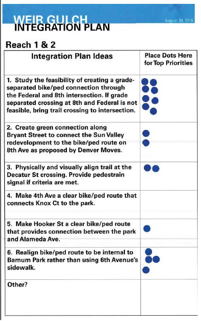
6 Round 3 Integration Plan Comments Map Comments & Responses Reach 1 & 2 The following comments were on the map: C: Make connection passable by bike (east of Federal) along with Federal Crossing. (near #1) C: Connection between Federal and South Platte C: How far would the Green Street at Bryant extend to the north? C: Include access to Lake via piers, boardwalk. Increase riparian area generally. Increase habitat and ways for humans to interact intimately, with the lowest impact. Integration Plan Ideas & Priorities 1. Study the feasibility of creating a grade-separated bike/ped connection trhough the Federal and 8 th intersection. If grade separated crossing at 8 th and Federal is not feasible, bring trail crossing to intersection. 2. Create green connection along Bryant Street to connect the Sun Valley redevelopment to the bike/ped route on 8 th Ave as proposed by Denver Moves. 3. Physically and visually align trail at the Decatur St crossing. Provide pedestrian signal if criteria are met 4. Make 4 th Ave a clear bike/ped route that connects Know Ct to the park. 5. Make Hooker St. a clear bike/ped route that provides connection between the park and Alameda Ave. 6. Realign bike/ped route to be internal to Barnum Park rather than using 6 th Avenue s sidewalk 8 dots 2 dots 2 dots 0 dots 1 dot 4 dots
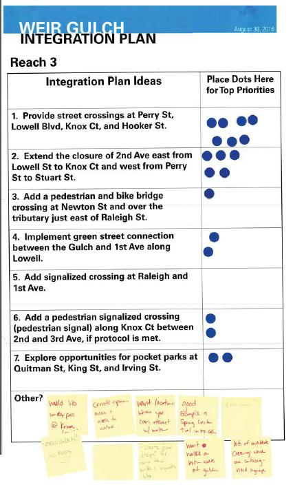
7 Round 3 Integration Plan Comments Reach 3 The following comments were on the map: C: Bring nature back to the built environment. Create access to this trhough peninsulas/peirs over water, accessible shorelines, water turbulence via falls/rapids. Riparian! C: Love the idea of a Green Street on Perry. Need warning Perry because of fast drivers. C: D.U.G. Community Orchard is planted and there is no room for playground. Benches in orchard would be nice. There are also community goats next to orchard. (at King, sought of 2 nd Ave.) C: Want underpasses for bike/ped. Integration Plan Ideas & Priorities 1. Provide street crossings at Perry St, Lowell Blvd, Knox Ct, and Hooker 7 dots St. 2. Extend the closure of 2 nd Ave east from Lowell St to Knox Ct and west 5 dots from Perry St to Stuart St. 3. Add a pedestrian and bike bridge crossing at Newton St and over the 1 dot tributary just east of Raleigh 4. Implement green street connection between the Gulch and 1 st Ave 2 dots along Lowell. 5. Add signalized crossing at Raleigh and 1 st Ave. 0 dot 6. Add a pedestrian signalized crossing (pedestrian signal) along Knox 2 dots Ct between 2 nd and 3 rd Ave, if protocol is met. 7. Explore opportunities for pocket parks at Quitman St, King St, and Irving St. 2 dots Other? C: Would like underpass at Knox (priority) C: Open Gulch!! NO PIPES. C: Create riparian areas and access to nature C: Want locations where you can interact with water. Good example is Spring Creek Trail in Ft. Collins. C: Create pool drops for water fowl, birds and aquatic life C: Riffle zones?
8 Round 3 Integration Plan Comments C: Want walks on both sides of gulch. C: Lots of mid-block crossings which are confusing need signage.
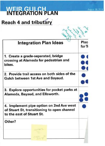
9 Round 3 Integration Plan Comments Reach 4 and tributary The following comments were on the map: C: Riparian areas in Barnum so people can interact and nature. C: Noxious weeds (along gulch between 1 st Ave and Bayaud Ave, and along Weir Drive) C: Illegal dumping (mattress, couches, etc) & activities (near Ellsworth & Raleigh St) C: Add wayfinding to get to bike path (at Bayaud and Utica St) C: Sewage smell (at Bayaud and Utica St) C: Ponding. Flow towards Utica St. (at Bayaud and Utica St) C: Roundabout? (at Weir Drive and Utica St) C: Access over water would be great if this was above regular storm water levels C: Report street racing on Bayaud. Consider traffic calming, green street, and/or better ped crossing for safety. Integration Plan Ideas & Priorities 1. Create a grade-separated, bridge crossing at Alameda for pedestrian and bikes. 2. Provide trail access on both sides of the Gulch between 1 st Ave and Bayaud. 3. Explore opportunities for pocket parks at Alameda, Bayaud, and Ellsworth. 4. Implement pipe option on 2 nd Ave west of Stuart St, transitioning to open channel to the east of Stuart St. 7 dots 3 dots 4 dots 1 dot Other? NO PIPES. Open Concept.
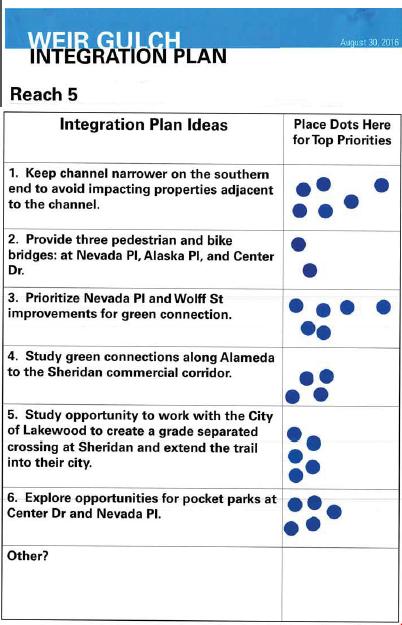
10 Round 3 Integration Plan Comments Reach 5 The following comments were on the map: C: GOCO Inspire grant. 3 team members. Westwood C: Grade Alameda C: Safe bike lane to Cedar Park (Cedar & Knox) along Knox to Alameda (south) Integration Plan Ideas & Priorities 1. Keep channel narrower on the southern end to avoid impacting 6 dots properties adjacent to the channel. 2. Provide three pedestrian and bike bridges: at Nevada Pl, Alaska Pl, 2 dots and Center Dr. 3. Prioritize Nevada Pl and Wolff St improvements for green connection 6 dots 4. Study green connections along Alameda to the Sheridan commercial 4 dots corridor. 5. Study opportunity to work with the City of Lakewood to create a 5 dots grade separated crossing at Sheridan and extend the trail into their city. 6. Explore opportunities for pocket parks at Center Dr and Nevada Pl. 5 dots
11
12
13
14
15
16
17
Tonight is for you. Learn everything you can. Share all your ideas.
 Strathcona Neighbourhood Renewal Draft Concept Design Tonight is for you. Learn everything you can. Share all your ideas. What is Neighbourhood Renewal? Creating a design with you for your neighbourhood.
Community Open House December 13, A project of the Green Infrastructure Center, supported by Skeo Solutions
 Community Open House December 13, 2011 A project of the Green Infrastructure Center, supported by Skeo Solutions Project Background The Green Infrastructure Center, Inc. (GIC) was formed in 2006 to help
Safe Routes to School: Munroe Elementary Walk Audit Report. Image: Drexel, Barrell & Co.
 Safe Routes to School: Munroe Elementary Walk Audit Report Image: Drexel, Barrell & Co. April 12, 2016 OVERVIEW As part of the 2014/2015 Denver Safe Routes to School (SRTS) Program, WalkDenver coordinated
RiNo Railroad Crossing Connectivity Analysis. Stakeholder Workshop June 29, 2017
 RiNo Railroad Crossing Connectivity Analysis Stakeholder Workshop June 29, 2017 Ideas and Considerations Presented at Stakeholder Workshop Primary Focus: 38 th Street (between Walnut & Wynkoop) 1 Basic
Hennepin County Bicycle and Pedestrian Planning
 Hennepin County Bicycle and Pedestrian Planning 1 Value of bicycle and sidewalk systems Safety Livability Mobility Health Personal Finances Economic Sustainability Clean Air Recreation Parking and congestion
Lee s Summit Road Improvement Study Public Open House June 7, 2007 Summary of Comment Card Responses
 Lee s Summit Road Improvement Study Public Open House June 7, 2007 Summary of Comment Card Responses Introduction At the Lee s Summit Road Improvement Study Public Open House held Thursday, June 7, 2007
Raleigh Park Open House #2 Summary (5/23/17)
") Raleigh Park Open House #2 Summary (5/23/17) Nearly 50 community members participated in an open house meeting about Raleigh Park on 5/23/17. During the meeting, staff presented concepts for changes to
Raleigh Park Open House #2 Summary (5/23/17) Nearly 50 community members participated in an open house meeting about Raleigh Park on 5/23/17. During the meeting, staff presented concepts for changes to
MARTIN LUTHER KING JR. WAY
 OCTOBER 2011 40 Vision and Goals The Martin Luther King, Jr. Way Illustrative Master Plan that follows has been developed through a process of community involvement. It expresses a long term vision for
FOCUS AREA 1 - Alberta Avenue Pocket Park 3 (121 Ave and 92 St)
") FOCUS AREA 1 - Alberta Avenue Pocket Park 3 (121 Ave and 92 St) New benches Plant evergreen trees Widen existing sidewalk from 1.5m to 1.8m Marked crosswalk 1.8m wide sidewalk Add pedestrian oriented lights
FOCUS AREA 1 - Alberta Avenue Pocket Park 3 (121 Ave and 92 St) New benches Plant evergreen trees Widen existing sidewalk from 1.5m to 1.8m Marked crosswalk 1.8m wide sidewalk Add pedestrian oriented lights
Living Streets Policy
 Living Streets Policy Introduction Living streets balance the needs of motorists, bicyclists, pedestrians and transit riders in ways that promote safety and convenience, enhance community identity, create
INTERSECTION IMPROVEMENTS
 MCHENRY COUNTY DIVISION OF TRANSPORTATION SEPTEMBER 2012 RIVER ROAD AT DOWELL ROAD INTERSECTION IMPROVEMENTS INSIDE: Public Meeting #1 Summary 1 Public Meeting #2 Summary 1 Key Issues Raised at Public
MISSISSIPPI EAST BANK TRAIL
 MINNEAPOLIS PARK AND RECREATION BOARD MISSISSIPPI EAST BANK TRAIL PUBLIC MEETING #3 10.28.2014 What We ve Heard: Feedback from Public Meeting #2 Items that are very important to the community: Trail lighting
UPTOWN REGIONAL BIKE CORRIDORS PROJECT SAN DIEGO ASSOCIATION OF GOVERNMENTS
 UPTOWN REGIONAL BIKE CORRIDORS PROJECT SAN DIEGO ASSOCIATION OF GOVERNMENTS SUMMARY REPORT: COMMUNITY UPDATE MEETING February 6, 2014 6 8:30 p.m. Roosevelt Middle School Library 3366 Park Blvd, San Diego
WELCOME. Stakeholder Involvement Group Meeting #2 Round Lake Public Works October 24, 2018
 WELCOME Stakeholder Involvement Group Meeting #2 Round Lake Public Works October 24, 2018 MEETING AGENDA 1. Welcome and Introductions 2. Study Progress Update 3. Problem Statement 4. Technical Analysis
Vision: Traditional hamlet with an attractive business/pedestrian friendly main street connected to adjacent walkable neighborhoods
 N D. Focus Area II Vision: Traditional hamlet with an attractive business/pedestrian friendly main street connected to adjacent walkable neighborhoods Transit Road Focus Area II is located in the Hamlet
Safe Streets. City of Lake Forest Park. March 21, 2017
 Safe Streets City of Lake Forest Park March 21, 2017 1 01 WELCOME 2 Agenda WELCOME WHAT IS THIS PROJECT? CONTEXT DRAFT CITYWIDE PROJECTS EXERCISE INTRODUCTION 3 02 WHAT IS THIS PROJECT? 4 WHAT IS THIS
2011 Capital Projects University Area - Community Council Priority List Municipality of Anchorage
 2011 Capital Projects University Area - Community Council Priority List Municipality of Anchorage 2 Project Management and Engineering Projects on 40th Ave Extension - Lake Otis Pkwy to Dale St $18,103,000
Reams Road RCA Study. Board of County Commissioners Public Hearing
 Reams Road RCA Study Board of County Commissioners Public Hearing April 24, 2018 Presentation Overview Study Overview Existing Conditions Development of Alternatives Preferred Alternative Public Involvement
City of Sammamish. Welcome. Issaquah-Fall City Road Improvements Project Phase I Design: 242nd Avenue SE to Klahanie Drive SE
 Welcome Welcome to the third community meeting for the Issaquah-Fall City Road Improvements Project. AGENDA 6:00 p.m. Welcome and sign-in 6:10 p.m. Presentation 6:50 p.m. Open house Learn about the roadway
Brooklyn Boulevard (County Road 152) Reconstruction Project Phase I. OPEN HOUSE June 20, 2017
 Reconstruction Project Phase I. OPEN HOUSE June 20, 2017") Brooklyn Boulevard (County Road 152) Reconstruction Project Phase I OPEN HOUSE June 20, 2017 Brooklyn Boulevard (County Road 152) Phase I Project Partners Project Lead Other Project Partners include Brooklyn
Brooklyn Boulevard (County Road 152) Reconstruction Project Phase I OPEN HOUSE June 20, 2017 Brooklyn Boulevard (County Road 152) Phase I Project Partners Project Lead Other Project Partners include Brooklyn
Duwamish Way-finding and CTR Report
 V. North Tukwila When the North Tukwila Manufacturing and Industrial Center was designated in 1992 as part of the region s land use and transportation plan, the plan called for the area to set a light-rail
SIDEWALK ASSESSMENT PHASE TWO
 2013 SIDEWALK ASSESSMENT PHASE TWO Table of Contents Lake of the Ozarks Council of Local Governments Sidewalk Assessment Phase TWO Criteria... 1 Communities Included In Sidewalk Assessment Phase TWO...
Bicycle and Pedestrian Plans and Improvements
 Bicycle and Pedestrian Plans and Improvements Presented to the City Council By Randle Harwood, Planning and Development, and Richard Zavala, Parks and Community Services September 24, 2013 Purpose Review
Safe Routes to School: Valverde Elementary Walk Audit Report. Image: CPLIVE, SkyscraperPage.com
 Safe Routes to School: Valverde Elementary Walk Audit Report Image: CPLIVE, SkyscraperPage.com April 28, 2016 1 OVERVIEW As part of the 2014/2015 Denver Safe Routes to School (SRTS) Program, WalkDenver
HARRISON STREET/OAKLAND AVENUE COMMUNITY TRANSPORTATION PLAN
 HARRISON STREET/OAKLAND AVENUE Community Workshop #4: Draft Plan Review December 3, 2009 D E S I G N, C O M M U N I T Y & E N V I R O N M E N T INTRODUCTIONS Key Project Staff: Alisa Shen, Project Manager,
Ocean Park Boulevard Green Street Project Alternatives & Trade Offs
 Planning Commission March 4, 2009 Ocean Park Boulevard Green Street Project Alternatives & Trade Offs Purpose of Tonight s Meeting Review concept plans and options Provide input on alternatives and trade-offs
Charlottesville Bike-Ped Steering Committee Meeting Notes 2/26/2015 Master Plan Update
 Charlottesville Bike-Ped Steering Committee Meeting Notes 2/26/2015 Master Plan Update Streets that Work meeting in December Progress since September SC meeting o Policy o Ped highlights o Bike planning
Chapter 3: Multi-Modal Circulation and Streetscapes
 CHAPTER 3: MULTI-MODAL CIRCULATION AND STREETSCAPES Chapter 3: Multi-Modal Circulation and Streetscapes Overview Streetscape improvements have already been completed for Depot Street between Main Avenue
Agency Advisory Group Meeting #3 and Walk Audit Anchorage Non-Motorized Plan
 Agency Advisory Group Meeting #3 and Walk Audit Anchorage Non-Motorized Plan Friday, May 18 th Walk Audit 10:00-11:30 AM Meeting 11:30 AM 1:00 PM Municipal Planning Department, 4700 Elmore Road, Training
Welcome. Thank you for your interest in the Lewis & Clark Viaduct Concept Study
 Welcome Thank you for your interest in the Lewis & Clark Viaduct Concept Study Please use the arrows in the upper left hand corner to navigate through the presentation. Use the envelope icon to ask a question
West Rail Line Update FasTracks Bike Jeffco. September 13, 2011
 West Rail Line Update FasTracks Bike Jeffco September 13, 2011 Bike route along the West Rail Line West Rail Line Bike Paths West Rail Line is a bike and pedestrian friendly project The bike path will
City of Davis East Covell Corridor Plan
 Community Open House #2 January 22, 2014 6:00 8:00 p.m. Veterans Memorial Center, Club Room City of Davis Introduction The (ECCP) is a taking a comprehensive look at the existing transportation systems
Saskatchewan Drive Roadway Rehabilitation and Shared-Use Path Widening
 Saskatchewan Drive Roadway Rehabilitation and Shared-Use Path Widening We are here today to present the draft plan for the Saskatchewan Drive Roadway Rehabilitation and Shared-Use Path Widening project
Poor pavement condition Substandard Intersections. / Substandard bike/pedestrian/transit accommodations. Driveway access Environmental concerns
 Public Informational Meeting University Avenue (Allen Boulevard Segoe Road) March 23, 2011 City of Madison City of Middleton Village of Shorewood Hills Dane County Existing Roadway Conditions Poor pavement
Project Goals and Objectives
 Project Goals and Objectives Goal 1: Goal 2: Goal 3: Transform Coast Highway into a Complete Street that accommodates all roadway users (pedestrians, bicyclists, and autos) Objectives: Improve the pedestrian
WalkShop. Highland Creek Village
 On June 5, 2014, 15 people participated in a for the Transportation Master Plan. The purpose of the was to receive feedback from a diverse range of local stakeholders and document existing transportation
Major Bike Routes 102 Avenue Workshop April 21, 2015
 Major Bike Routes 102 Avenue Workshop April 21, 2015 Our Purpose Today Provide context on how Major Bike Routes fit into Edmonton s future Share information on what we heard in our last phase, and how
Austin Avenue Bridges Project. Public Meeting Summary
 Austin Avenue Bridges Project Public Meeting Summary June 29, 2016 Red Table Safety and Connectivity Notes: 1. Would like to see forensic report evaluations 2. What is the lifespan? 3. Extend safety considerations
Pedestrian, Bicycle and Traffic Calming Strategic Implementation Plan. January 18, 2011
 Pedestrian, Bicycle and Traffic Calming Strategic Implementation Plan January 18, 2011 Tonight s Agenda Receive update on project Provide feedback on two policy issues Complete Streets Policy Project Prioritization
TRANSPORTATION COMMISSION Agenda Staff Report
 TRANSPORTATION COMMISSION Agenda Staff Report Agenda Item No. 5.a DATE: JULY 31, 2014 TO: FROM: SUBJECT: TRANSPORTATION COMMISSION COMMUNITY DEVELOPMENT DEPARTMENT - PLANNING DRAFT OLYMPIC CORRIDOR PREFERRED
Corpus Christi Metropolitan Transportation Plan Fiscal Year Introduction:
 Introduction: The Safe, Accountable, Flexible, Efficient Transportation Equity Act: A Legacy for Users (SAFETEA-LU) has continued the efforts started through the Intermodal Surface Transportation Efficiency
BETHEL ROAD AND SEDGWICK ROAD CORRIDOR STUDY
 DRAFT PLAN City Council Meeting August 14, 2017 STUDY AREA Sedgwick Corridor State Route 160, principal arterial with Class 3 access management designation, commuter and freight route, connection to SR
Merrick and Memorial Neighborhood Study 5/14/2014 Public Meeting
 Merrick and Memorial Neighborhood Study 5/14/2014 Public Meeting Study Area April 9 Public Meeting Comments Summary Pedestrian Safety - A Walking Neighborhood Pedestrian traffic is very difficult A need
TOWN OF PARADISE VALLEY
 TOWN OF PARADISE VALLEY The Paradise Valley Bicycle & Pedestrian Master Plan Planning Commission January 16, 2018 Purpose of Today s Meeting Review January 2018 draft plan Input on compliance to SOD Review
Project Update May 2018
 Project Update May 2018 Dakota County, in cooperation with the City of Lakeville, is planning to reconstruct 202 nd Street West (County Road 50) from Holyoke Avenue to Cedar Avenue (County Road 23). 202
What Is a Complete Street?
 Session 5 Charleen Zimmer, AICP, Zan Associates May 5-7, 2010 What Is a Complete Street? May 2010 5-1 Not a Complete Street More of a Complete Street May 2010 5-2 Benefits of Complete Streets Safety for
City of Charlottesville Bicycle and Pedestrian Master Plan Update
 City of Charlottesville Bicycle and Pedestrian Master Plan Update September 17, 2014 I. Welcome and meeting overview II. Project status update III. Network overview IV. Break-out groups Pedestrian Network
MINERAL AVENUE CORRIDOR ASSESSMENT STUDY IMPLEMENTATION STRATEGY
 MINERAL AVENUE CORRIDOR ASSESSMENT STUDY IMPLEMENTATION STRATEGY INTRODUCTION City Personnel Sign-in Sheet Comment Forms Please Write Down Any Feedback INTRODUCTION List of Topics for Presentation Study
Executive Summary Route 30 Corridor Master Plan
 Route Corridor Master Plan Project Overview The Route Corridor Master Plan is a coordinated multimodal transportation and land use plan for the entire stretch of Route through East Whiteland Township,
Welcome to the Sellwood Bridge Project Open House!
 Welcome to the Sellwood Bridge Project Open House! 5:30 7:30 pm Please sign in here Information stations and project staff are located throughout the room. Goals for Tonight s Meeting: Learn how the Preferred
HELM RANCH ROUND 2 - COMMUNITY WORKSHOP AND OPEN HOUSE SUMMARY
 HELM RANCH ROUND 2 - COMMUNITY WORKSHOP AND OPEN HOUSE SUMMARY Tarpey Elementary School, Clovis, CA October 15, 2014 6:30pm-8:30pm OVERVIEW On Wednesday, October 15, 2014, staff from the City of Clovis
THE ALAMEDA CONCEPT DESIGN COMMUNITY MEETING 3. A Plan for The Beautiful Way JANUARY 28, 2010
 CONCEPT DESIGN COMMUNITY MEETING 3 JANUARY 28, 2010 AGENDA INTRODUCTION COMMUNITY INPUT ROADWAY STUDIES STREETSCAPE DESIGN STATIONS DISCUSSION SUMMARY AND DISCUSSION NEXT STEPS CLOSE INTRODUCTION SCHEDULE
122 Avenue: 107 Street to Fort Road
 : 107 Street to Fort Road November 24, 2015 4:30 8:00 p.m. Meeting Purpose Summarize project work completed to date Share results of public input from Phase 1 Share the draft concept plan and proposed
Commerce Street Complete Street Project from Good Latimer Expressway to Exposition Avenue
 Commerce Street Complete Street Project from Good Latimer Expressway to Exposition Avenue T A N Y A B R O O K S A S S I S T A N T D I R E C T O R M O B I L I T Y P L A N N I N G M O B I L I T Y A N D S
Chapter 5 Future Transportation
 Chapter 5 Future Transportation The Future Land Use Plan identifies the desired land use designations. The land uses desired for Crozet depend, in large part, on the success of the transportation system,
50 Avenue S.W. Corridor Study Glenmore Aquatic Centre Drop-In Event
 Project overview The City of Calgary is conducting a transportation corridor study of 5 Avenue S.W., between Crowchild Trail and 4A Street S.W. In 29, it was reclassified as a Parkway under the Calgary
CONNECTING PEOPLE TO PLACES
 CONNECTING PEOPLE TO PLACES 82 EAST BENCH MASTER PLAN 07 Introduction The East Bench transportation system is a collection of slow moving, treelined residential streets and major arteries that are the
Miami Health District
 Miami Health District Streetscapes, Gateways, and Signage Basis of Design Report Study Miami Partnership Meeting July 21, 2008 Gannett Fleming EDAW The Corradino Group Sponsored by the Miami Partnership:
Public Information Centre
 WELCOME Public Information Centre Father Tobin Road Lougheed Middle School - Library Wednesday November 7, 2012 7:00 p.m.to 9:00 p.m. Please sign in Neighbourhood Traffic Calming Guide Background The City
TRANSPORTATION NEEDS ASSESSMENT
 TRANSPORTATION NEEDS ASSESSMENT A travel demand analysis was carried out to determine the operational issues and the potential benefit that adding traffic capacity would have on the road network. All the
REPORT OF MEETING DOWNTOWN CROSSING PHASE 2 PUBLIC INFORMATION MEETING. Ives Main Library 133 Elm Street, New Haven, Connecticut September 29, 2014
 REPORT OF MEETING DOWNTOWN CROSSING PHASE 2 PUBLIC INFORMATION MEETING Ives Main Library 133 Elm Street, New Haven, Connecticut September 29, 2014 Technical Teams City of New Haven Honorable Toni M. Harp,
CLOSED. The draft concept design has been broken down into 5 categories for the purpose of this survey:
 Old Strathcona s neighbourhood renewal process is now at the draft concept design phase. Over the last several months, the city has been gathering local knowledge and resident input that has been used
City of North Mankato Parks Master Plan 2015 Citizen Input
 Date/Name What park do you visit most? Why? 1/23/15 Bluff and King Arthur 1/23/15 Reserve - It is the closest park to our house and the only park we have access to if we want to walk on a sidewalk/trail
Thank you for attending
 Improving mobility safety comfort WELCOME Thank you for attending The purpose of this meeting is to: Learn about the project Prioritize potential walking and biking improvements on Snelling Ave Gather
Pattullo Bridge Replacement Project Community Connections Phase 2 Consultation. Appendix 3: Open House Display Boards
 Replacement Project Community Connections Phase 2 Consultation Appendix 3: Open House Display Boards November 2016 Welcome! Welcome to the Replacement Project Public Open House We Want to Hear from You
Clarkson Walkability Audit: Results and Recommendations Summary
 Clarkson Walkability Audit: Results and Recommendations Summary The following document was prepared by the Region of Peel and includes a summary of comments made by participants during our breakout discussion
42nd Ave N Reconstruction
 CITY OF MINNEAPOLIS 42nd Ave N Reconstruction Community Meeting #2 May 2016 6:00 7:30 p.m. 5/16/2016 1 Purpose of Meeting Inform: Provide an overview of project, identify anticipated scope of work, and
Bicycle and Pedestrian Facilities Toolbox (Excerpt from Figure 3.1)
") Appendix B Neighborhood Connections Summaries This Appendix is a supplement to the information presented in Chapter 3 Connect People. The Appendix includes a summary or profile for each of the proposed
Appendix B Neighborhood Connections Summaries This Appendix is a supplement to the information presented in Chapter 3 Connect People. The Appendix includes a summary or profile for each of the proposed
Caltrans Sloat Boulevard Pedestrian Safety Project Response to Community Questions, Comments & Concerns
 Caltrans Sloat Boulevard Pedestrian Safety Project Response to Community Questions, Comments & Concerns Revised: May 10, 2016 The California Department of Transportation (Caltrans) is planning various
Urbana Pedestrian Master Plan
 Urbana Pedestrian Master Plan Recommendations Gabe Lewis, Transportation Planner Champaign County Regional Planning Commission November 15, 2018 Public Meeting #2 Public Input Round #1 Thank You! 10 public
RED BANK CORRIDOR. Community Partners Committee Meeting Madisonville Recreation Center. May 21,
 RED BANK CORRIDOR Community Partners Committee Meeting Madisonville Recreation Center May 21, 2013 RED BANK CORRIDOR PROJECT Create a balance of mobility and access to better serve local communities, businesses
Orinda Bicycle, Trails and Walkways Master Plan
 Orinda Bicycle, Trails and Walkways Master Plan Public Meeting October 15, 2008 Presented by: Ian Moore, Alta Lauren Ledbetter, Alta Bruce Wolff, Alta Introductions City of Orinda Monica Pacheco, Assistant
Streetscape: Core Shopping District
 Streetscape: Core Shopping District DRAFT DRAFT DRAFT May 00 Core Shopping District: Phase Blue Island s Core Shopping District is located along Western Avenue, between Grove and Union Streets. Streetscape
Mark Malone, P.E. SD DOT
 Mark Malone, P.E. SD DOT SD10 Grading & Surfacing From 8 th Ave W to 8 th Ave E 1 mile plus transition lengths Complete Urban Reconstruction Grading, C&G, Storm Sewer, Sidewalk, Concrete Surfacing Railroad
CITY OF ELKO BICYCLE AND PATHWAY PLAN
 CITY OF ELKO BICYCLE AND PATHWAY PLAN INTRODUCTION: The City of Elko is intended to provide the basic framework for the development of a functional bicycle and pathway system for the community with connections
City of Gainesville Transportation/Roadway Needs PROJECT SUMMARY
 A1 Roadway Resurfacing $23,846,000 TYPE: Preservation of existing system Roadway resurfacing A2 Signal Replacement $6,000,000 TYPE: Preservation of existing system Replace traffic signals. B1 W 6th St
Ocean Park Boulevard Streetscape Improvement Project Alternatives & Trade Offs
 City Council Study Session January 27, 2009 Ocean Park Boulevard Streetscape Improvement Project Alternatives & Trade Offs Scope of Work Purpose of Tonight s Meeting Review work to date and direct staff
Building Great Neighbourhoods BELLEVUE AND VIRGINIA PARK
 Building Great Neighbourhoods BELLEVUE AND VIRGINIA PARK This is Meeting 2 Unfortunately, some residents in Bellevue and Virginia Park received the wrong information for this public open house (Meeting
Safe Routes to School Action Plan Aberdeen, Idaho
 Background Aberdeen, Idaho is a largely agricultural community of nearly 2,000 people and is located in the southeast portion of the state on the western edge of American Falls Reservoir. The community
Chapter 11. Culverts and Bridges Design Checklist for Culvert Design
 Yes No N/A Design Requirements I. GENERAL DESIGN GUIDELINES Chapter 11. Culverts and Bridges A. Culvert design is in accordance with the Culverts chapter of Volume 2 of the UDFCD Manual for additional
Cherry Creek Transportation and Land Use Forum September 25, 2013 Meeting Summary
 Cherry Creek Transportation and Land Use Forum September 25, 2013 Meeting Summary I. LEAD-IN TO SMALL GROUP DISCUSSION, POLLING AND STEERING COMMITTEE/TECHNICAL TASK FORCE DISCUSSION The meeting began
DRAFT. System Components. Greenway Trails. Introduction. Trail Types. Zebulon Greenway Master Plan
 5 System Components Wakefield Street Photo Simulation showing Sharrows Introduction The Master Plan identifies various system components that, together, create a comprehensive greenway system. These components
 Time of Change We Are Growing We Are An Attractive Place To Live We Are Age Diverse + Living Longer 50000 40000 30000 20000 10000 0 2010 Census Job Density Housing Sheds Transit Sheds The Project FUNDING
Montford Drive Parking & Circulation Study
 Montford Drive Parking & Circulation Study Parking & Circulation Study Follow up to the Area Plan based on what we heard Purpose 1 2 3 4 To look closer and evaluate parking and network related issues (including
WELCOME. Thank you for joining us at the Second Public Workshop for the Carlsbad Pedestrian Master Plan. We look forward to receiving your feedback.
 City of Carlsbad Pedestrian Master Plan: WELCOME WELCOME Please Sign In Provide Input at Flip Charts Review Boards Presentation of Draft Plan Thank you for joining us at the Second Public Workshop for
Table #6 VISION CHARACTERISTICS
 Table #6 VISION White Flint is a place to live, work, play, shop, and walk with sufficient density to encourage quality redevelopment. Vibrant streets and consistent streetscapes are important. CHARACTERISTICS
Active Transportation Rail to River Corridor. Community Meeting - Segment A
 Active Transportation Rail to River Corridor Community Meeting - Segment A June 29, 2017 Tonight s Agenda > Open House (30 min) > Welcome / Project Overview > Presentation of 30% Design Refinements > Next
STONY PLAIN ROAD STREETSCAPE
 Jasper Place Revitalization Strategy: Vision The people involved in the Jasper Place Revitalization Strategy envision: Goal 1: Feeling safe in our community Create a community where feeling safe is common--where
» Draft Recommendations» Discussion» Next Steps. Plan for Walking and Biking
 SAC Meeting Plan #3 for September Walking and 12, Biking 2018 » Draft Recommendations» Discussion» Next Steps Plan for Walking and Biking » Stakeholder and Public Outreach» Background data collection and
TOWN OF PORTLAND, CONNECTICUT COMPLETE STREETS POLICY
 TOWN OF PORTLAND, CONNECTICUT COMPLETE STREETS POLICY I. VISION, GOALS & PRINCIPLES VISION To improve the streets of Portland making them safer and more accessible for all users including pedestrians,
Rabbit Creek Community Council
 Rabbit Creek Community Council P.O. Box 112354, Anchorage, AK 99511-2354 Page 1 To: Troy Swanson, Office of the Mayor Christine Chesnut, OMB Budget Analyst Gary Jones, Public Works Dear Staff, May 31,
Montgomery County Life Sciences Center Loop Trail
 Montgomery County Life Sciences Center Loop Trail Advisory Committee Meeting #1 February 10, 2015 Agenda 1. Project Background 2. Existing Conditions Analysis 3. Examples from Elsewhere 4. Discussion Project
PROPOSED BICYCLE AND PEDESTRIAN FACILITY Vicinity of Route 123/I-495 Interchange Tysons, Fairfax County, Virginia
 PROPOSED BICYCLE AND PEDESTRIAN FACILITY Vicinity of Route 123/I-495 Interchange Tysons, Fairfax County, Virginia PRELIMINARY ENGINEERING REPORT Prepared for: Prepared by: July 2017 Table of Contents 1
Atwood Avenue Fair Oaks Avenue Cottage Grove Road
 Atwood Avenue Fair Oaks Avenue Cottage Grove Road Agenda Purpose Review project scope & goals Present design alternatives Gather feedback Answer Questions Format Open House Presentation Q&A Open House
City of Madison, East Johnson Street North Baldwin Street to First Street Local Street Dane County
 City of Madison, East Johnson Street North Baldwin Street to First Street Local Street Dane County Public Involvement Meeting Thursday, November 10, 2016 5:30 to 7 P.M. Festival Foods 810 E. Washington
Welcome. Background. Goals. Vision
 Welcome The formal Public Information Centre (PIC) for the Transportation Master Plan How We GO will be held in early 2017. At that time we will present the recommended transportation system for Niagara
Appendix B - Street Sections
 Appendix B - Street Sections 6TH STREET CORRIDOR PLAN STREET SECTIONS The street sections in Appendix B include recommended improvements to streets for North Glenwood. They include existing conditions
NEWMARKET UPHAM S CORNER
 SOUTH STATION Planning Initiative NEWMARKET UPHAM S CORNER COLUMBIA ROAD (P) FOUR CORNERS/GENEVA Working Advisory Group (WAG) Meeting #5 TALBOT AVENUE MORTON STREET BLUE HILL AVE/CUMMINS HWY (P) RIVER
Summaries from the Concentric Circle Exercises 10 Neighborhood Forums held in April and May 2018 Various locations around Town
 Summaries from the Concentric Circle Exercises 10 Neighborhood Forums held in April and May 2018 Various locations around Town A Concentric Circle exercise was conducted at all 10 neighborhood meetings.
TRANSPORTATION & MOBILITY VISIONING MEETING. August 23 24, 2017
 TRANSPORTATION & MOBILITY VISIONING MEETING August 23 24, 2017 Project Team 1999 South Lakefront Framework Plan In 1999, the Chicago Park District authorized framework plans for three historic parks: Jackson,