SIDEWALK ASSESSMENT PHASE TWO
|
|
|
- Gwenda Morrison
- 5 years ago
- Views:
Transcription

1 2013 SIDEWALK ASSESSMENT PHASE TWO
2 Table of Contents Lake of the Ozarks Council of Local Governments Sidewalk Assessment Phase TWO Criteria... 1 Communities Included In Sidewalk Assessment Phase TWO... 2 Sidewalk Questionnaire/Survey Results...2 Assessment Procedure... 3 Summary of Completion Phase TWO... 3 Assessment Area Maps Camden County Camdenton Maps and Photos Linn Creek Maps and Photos Osage Beach Maps and Photos Village of Four Seasons Maps and Photos Assessment Area Maps Miller County Eldon Maps and Photos Iberia Maps and Photos Lake Ozark Maps and Photos Conclusion Appendix... A Camdenton Questionnaire/Survey Results...A-1 Osage Beach Questionnaire/Survey Results...A-2
3 Lake of the Ozarks Council of Local Governments Sidewalk Assessment Phase TWO Criteria Lake of the Ozarks Council of Local Governments (LOCLG) in collaboration with Missouri Department of Transportation (MoDOT) has agreed as part of our approved MoDOT 2012 Work Plan to incorporate the sidewalk assessment project. The purpose of the project is to assess and document the already existing infrastructure in various cities within our four county region of Camden, Laclede, Miller, and Morgan counties. The data collected will be used in our regional transportation planning, including establishing local priorities, potential grant applications, and participation in the Safe Routes to School Program. MoDOT established the threshold for the assessment to be towns with over 1,000 in population. This severely limited the number of our cities because of their smaller populations. With permission from MoDOT, we realigned our criteria to accommodate our smaller communities. We established that we would assess all cities with a population of 750 or more, as well as any communities that expressed an interest to have their sidewalks included in the inventory. Assessments will include the collection of data regarding general information about pedestrian infrastructure as well as accessing the physical condition of all existing sidewalks. Sidewalk Assessment Phase Two included the counties of Camden and Miller. LOCLG sent out a questionnaire/survey to each of the municipalities within these two counties to gather information about sidewalks within their jurisdiction. After this information was collected, LOCLG performed an extensive physical assessment of each of the sidewalks in the towns established to have sidewalks and a population of 750 or more. The communities of Linn Creek and Iberia requested to be included in the sidewalk assessment process, as both have an existing sidewalk network, as well as new sidewalk projects. 1
4 Communities Included in Sidewalk Assessment Phase Two The sidewalks in each community with over 750 in population as established by the Census 2010 were assessed. Camden County Camdenton Population 3,718 Linn Creek Population 124 Osage Beach Population 4,351 Village of Four Seasons Population 2,217 Miller County Eldon Population 4,567 Iberia Population 736 Lake Ozark Population 1,586 Sidewalk Questionnaire/Survey Results The communities that met the criteria in Camden and Miller counties were sent a questionnaire/survey to help preliminarily assess the existence of sidewalks. The questionnaire/survey also helped us to establish the current conditions of those sidewalks, and to see if there was significant interest in the creation and maintenance of a sidewalk system in their community. Copies of the questionnaire/surveys that were returned can be found in Appendix A. The chart below reflects the communities to which a questionnaire/survey was mailed. Community Survey Feedback Sidewalks Camdenton Yes Survey Returned Yes Linn Creek No Survey Returned Yes Osage Beach Yes Survey Returned Yes Village of Four Seasons No Survey Returned Yes Eldon No Survey Returned Yes Iberia No Survey Returned Yes Lake Ozark No Survey Returned Yes 2
5 Assessment Procedure LOCLG staff traveled to each identified city to collect more data and physically assess the conditions of all the sidewalks within the city limits. Using the chart below as our guide, each sidewalk was graded and mapped. Condition/Grade Good Fair Poor Gap Standard Criteria Unlikely to hinder mobility of the average pedestrian. The sidewalk is free from significant cracking, buckling, gravel surfaces, or other debris, which would impede pedestrian traffic. Uneven and distressed surface that hinders mobility of the average pedestrian. The sidewalk contains surface cracks, vegetation overgrowth, or debris. Impassable to mobility impaired pedestrians; hinders mobility of average pedestrians. The sidewalk has deep cracking and buckling, significant vegetative overgrowth, poor drainage, bulging surface (due to tree roots) and/or debris such that pedestrian travel would be impeded. No sidewalk is present. Not mapped. Summary of Completion Phase Two A combined total of 238,977 feet ( miles) of existing sidewalks were assessed and documented in the completion of Phase Two. The chart below reflects the overall sidewalk conditions in each county. Condition Camden County Miller County Good 81,338 32,818 Fair 66,885 23,986 Poor 3,770 30,180 Combined TOTAL 151,993 86,984 Based on the combined total of all sidewalks assessed, we determined the percentages in relation to the condition of these sidewalks to develop an overall perspective. Condition Camden County Compared to Phase Two Overall Total Sidewalks Assessed Miller County Compared to Phase Two Overall Total Sidewalks Assessed Good 34% 14% Fair 28% 10% Poor 1% 13% 3
6 To drill down further we evaluated the percentages of the county totals in relation to each county s overall sidewalks combined totals in order to evaluate the information strictly on a countywide basis. Condition Camden County Compared to Camden County Total Sidewalks Assessed Miller County Compared to Miller County Total Sidewalks Assessed Good 54% 38% Fair 44% 28% Poor 2% 34% 4

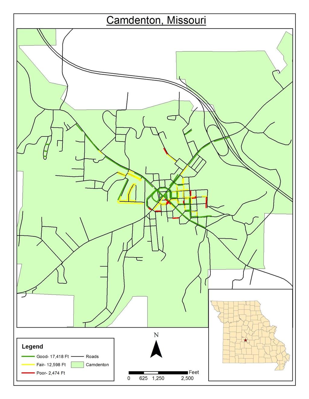
7 Assessment Area Maps Camden County Camdenton Condition Good Fair Poor TOTALS Camdenton, Camden County 17,418 Ft 12,598 Ft 2,474 Ft 32,490 Ft 5
8 6


9 Hwy 54 bridge overpass of Highway 5 Good Condition Fair Condition Hwy 54 6 blocks east of Hwy 54/5 intersection (square) 7 Hwy 5 and Minor Avenue Poor Condition
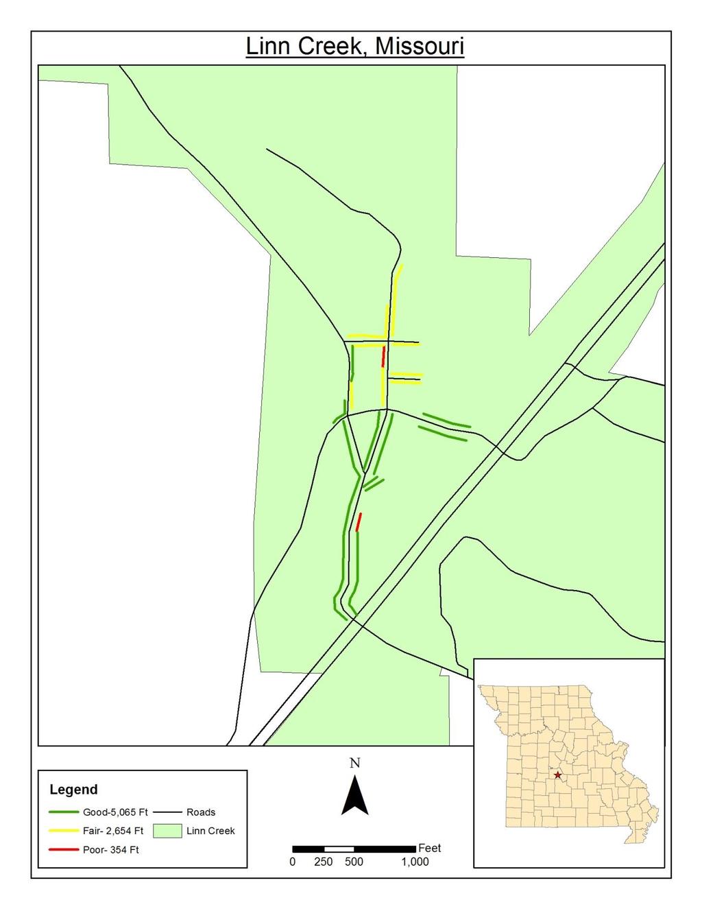
10 Linn Creek Condition Good Fair Poor TOTALS Linn Creek, Camden County 5,065 Ft 2,654 Ft 354 Ft 8,073 Ft 8
11 9


12 East side of Lake Street Good Condition Fair Condition West side of Lake Street 10


13 Cherry Street Poor Condition Gap Condition Lake Street Bridge 11
14 Osage Beach Condition Good Fair Poor TOTALS Osage Beach, Camden County (partially Miller County) 41,237 Ft 34,058 Ft 942 Ft 76,237 Ft 12

15 13


16 Passover Road by Windjammer Good Condition Fair Condition Bluff Drive on Sunset The City of Osage Beach submitted a map displaying their proposed plan for future sidewalk development. Their proposed map also includes future trail and boardwalk development. 14
17 15
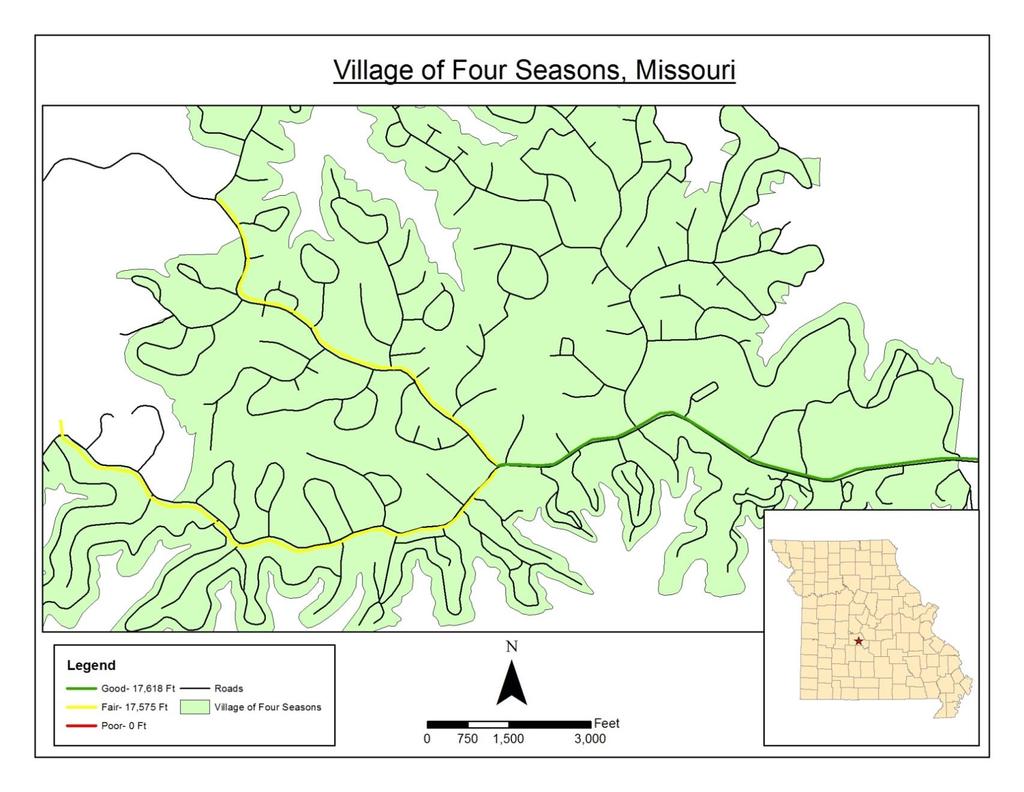
18 Village of Four Seasons Condition Good Fair Poor TOTALS Four Seasons, Camden County 17,618 Ft 17,575 Ft 0 Ft 35,193 Ft 16
19 17


20 Route HH Good Condition Fair Condition Bittersweet Road 18

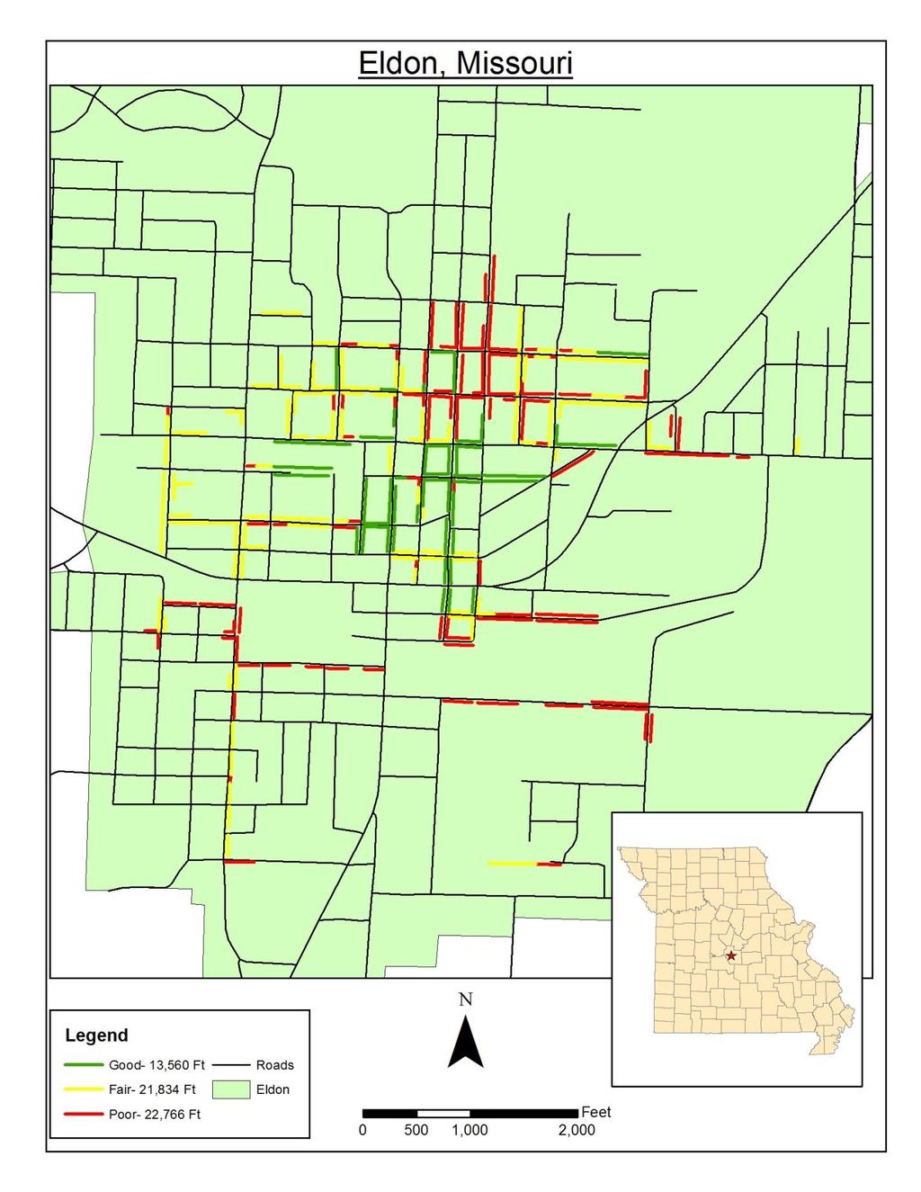
21 Eldon Assessment Area Maps Miller County Condition Good Fair Poor TOTALS Eldon, Miller County 13,560 Ft 21,834 Ft 22,766 Ft 58,160 Ft 19
22 20


23 E. North Street and Highway 87 Good Condition Fair Condition Oak Street Corner of Mill Street and Newton Street Poor Condition 21
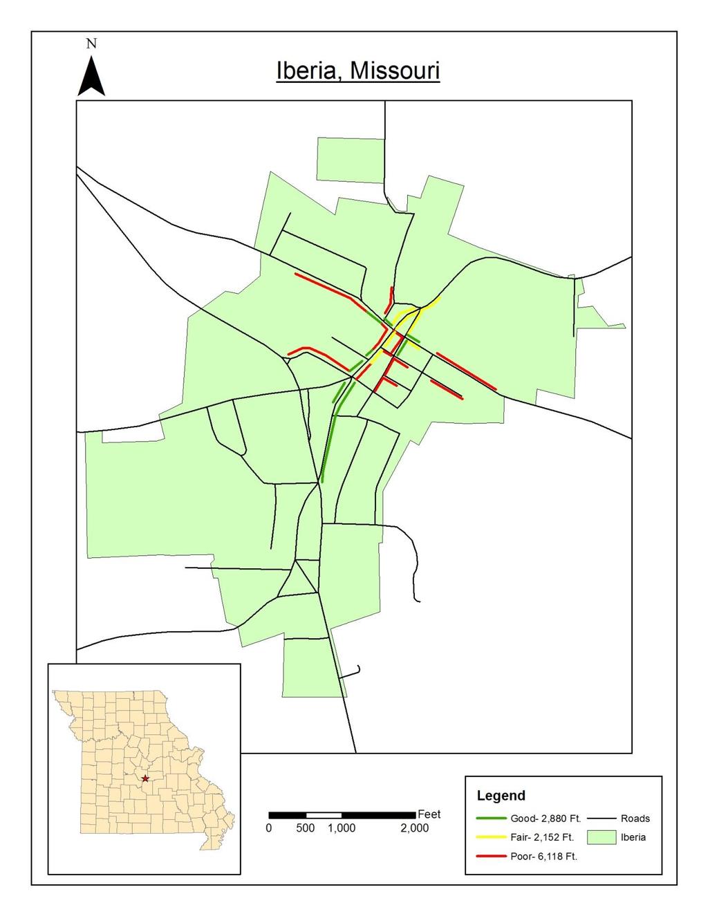
24 Iberia Condition Good Fair Poor TOTALS Iberia, Miller County 2,880 Ft 2,152 Ft 6,118 Ft Ft 22
25 23


26 Lombar Street near Hwy 17 Good Condition Fair Condition Hwy 17 near Lombar Street 24 Hwy 42 near Pearl St. Poor Condition
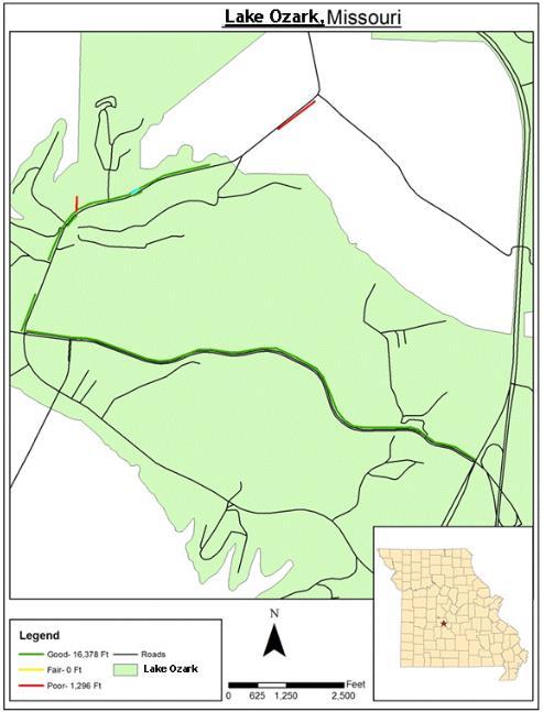
27 Lake Ozark Condition Good Fair Poor TOTALS Lake Ozark, Miller County 16,378 Ft 0 Ft 1,296 Ft 17,164 Ft 25
28 26


29 Bagnell Dam Blvd on the Strip Good Condition Poor Condition Ballenger Rd and Bagnell Dam Blvd. 27
30 Conclusion Sidewalks are a community investment, not only in building the needed infrastructure but also in the added benefits to our local residents. Sidewalks provide safety and security for both pedestrians and drivers on the road. Sidewalks enhance our neighborhoods while encouraging community connections. There are also environmental and economic benefits to a sidewalk system. Maintaining and improving our already existing sidewalks, as well as investing in the building of new sidewalks needs to be a part of our regional planning approach. In rural parts of Missouri is it often overlooked as a viable infrastructure project, but we need to consider sidewalks as an added benefit to our communities. Sidewalk Assessment Phase Two is complete; the final results will be shared with our community leaders. The final report will also serve as a planning document for the Transportation Advisory Committee (TAC). 28
31 SIDEWALK ASSESSMENT PHASE TWO APPENDIX A Appendix A: Questionnaire/Survey Results LAKE OF THE OZARKS COUNCIL OF LOCAL GOVERNMENTS
32
33
34
35
36
TABLE OF CONTENTS. Executive Summary
 Executive Summary Background... ES-1 Pedestrian Network... ES-2 Bikeway Network... ES-2 Collision History... ES-2 Public Input... ES-4 Conclusions and Recommendations... ES-4 1. Introduction and Setting
ACTION TRANSMITTAL No
 Transportation Advisory Board of the Metropolitan Council of the Twin Cities ACTION TRANSMITTAL No. 2016-15 DATE: January 14, 2016 TO: TAC Planning Committee PREPARED BY: Steven Elmer (651) 602-1756 SUBJECT:
WALKNBIKE DRAFT PLAN NASHVILLE, TENNESSEE EXECUTIVE SUMMARY NASHVILLE, TENNESSEE
 NASHVILLE, TENNESSEE EXECUTIVE SUMMARY Executive Summary A world-class multi-modal transportation system is essential to a vibrant city and better quality of life. -Mayor Barry The WalknBike plan aims
Goal 3: Foster an environment of partnerships and collaboration to connect our communities and regions to one another.
 Non-Motorized Transportation Plan (NMTP) Draft Vision, Goal and,, Tri-County Regional Planning Commission (TCRPC) Purpose The purpose of the Tri-County Regional Planning Commission (TCRPC) Non-Motorized
TRANSPORTATION & MOBILITY
 TRANSPORTATION & MOBILITY ROADWAY SYSTEM There are approximately 40 miles of roadways in Manitou Springs. For planning purposes, roadways are typically assigned a functional classification which defines
Hennepin County Bicycle and Pedestrian Planning
 Hennepin County Bicycle and Pedestrian Planning 1 Value of bicycle and sidewalk systems Safety Livability Mobility Health Personal Finances Economic Sustainability Clean Air Recreation Parking and congestion
BIKE PLAN CONTENTS GATEWAY
 CONTENTS Acknowledgments...vii Great Rivers Greenway District Board of Directors... vii Great Rivers Greenway District Staff... vii Project Consultants... vii Committees... viii Citizens Advisory Committee
ADOT Statewide Bicycle and Pedestrian Program Summary of Phase IV Activities APPENDIX B PEDESTRIAN DEMAND INDEX
 ADOT Statewide Bicycle and Pedestrian Program Summary of Activities APPENDIX B PEDESTRIAN DEMAND INDEX May 24, 2009 Pedestrian Demand Index for State Highway Facilities Revised: May 29, 2007 Introduction
MAG Town of Cave Creek Bike Study Task 6 Executive Summary and Regional Significance Report
 Page 1 MAG Town of Cave Creek Bike Study Task 6 Executive Summary and Regional Significance Report August 1, 2012 MAG Project #481 Page 2 Task 6 Executive Summary and Regional Significance Report Introduction
ADA TRANSITION PLAN 2013
 ADA TRANSITION PLAN 2013 TABLE OF CONTENTS Contents Introduction 1 Purpose 2 Identified Obstacles to the Public Right of Way 3 Criteria for Determining Impediments at Village Facilities 4 Removing Barriers
THE CORPORATION OF THE DISTRICT OF CENTRAL SAANICH. COMMITTEES - 7:00 PM Monday, April 27, 2015 Council Chambers AGENDA
 THE CORPORATION OF THE DISTRICT OF CENTRAL SAANICH COMMITTEES - 7:00 PM Monday, April 27, 2015 Council Chambers AGENDA 1. CALL TO ORDER 2. ADOPTION OF AGENDA 3. ADOPTION OF MINUTES 4. PRESENTATIONS AND
Pedestrian Project List and Prioritization
 To: Kyle Wagenschutz, City of Memphis CC: From: Anne Conlon and John Cock, Alta Planning + Design Date: December, 2014 Re: Project List Development (Task 3.1-3.2) and Project List Prioritization (Task
3.0 Future Conditions
 3.0 Future Conditions In order to be able to recommend appropriate improvements to the transportation system of the Town, it is important to first understand the nature and volume of traffic that is expected
ACTION TRANSMITTAL No
 Transportation Advisory Board of the Metropolitan Council of the Twin Cities ACTION TRANSMITTAL No. 2016-15 DATE: January 14, 2016 TO: FROM: TAC TAC Planning PREPARED BY: Steven Elmer (651) 602-1756 SUBJECT:
This page intentionally left blank.
 This page intentionally left blank. COMMUNITY Coweta Community Overview Coweta Coweta, a residential community located in Wagoner County, is a suburb of Tulsa situated southeast of the metropolitan area
Draft. Lecompton. Table of Contents. Background
 Lecompton Table of Contents Existing Infrastructure 80 Funding 82 Policy and Program Recommendations 83 Infrastructure Implementation Scenarios 84 Conclusion 85 Douglas County Lecompton Background Located
2011 Capital Projects University Area - Community Council Priority List Municipality of Anchorage
 2011 Capital Projects University Area - Community Council Priority List Municipality of Anchorage 2 Project Management and Engineering Projects on 40th Ave Extension - Lake Otis Pkwy to Dale St $18,103,000
This page intentionally left blank.
 This page intentionally left blank. COMMUNITY Glenpool Community Overview Glenpool Glenpool is a city of nearly 12,000 residents located in Tulsa County southwest of Tulsa and Jenks. The city is growing
RESOLUTION NO ?? A RESOLUTION OF THE CITY OF NEPTUNE BEACH ADOPTING A COMPLETE STREETS POLICY
 RESOLUTION NO. 2018-?? A RESOLUTION OF THE CITY OF NEPTUNE BEACH ADOPTING A COMPLETE STREETS POLICY WHEREAS, safe, convenient, and accessible transportation for all users is a priority of the City of Neptune
Bikeway action plan. Bicycle Friendly Community Workshop March 5, 2007 Rochester, MN
 Bikeway action plan Summary The was held on March 5, 2007 at the Rochester Mayo Civic Center. The workshop was hosted by Rochester-Olmsted County Planning Department in collaboration with the League of
Lee s Summit Road Improvement Study Public Open House June 7, 2007 Summary of Comment Card Responses
 Lee s Summit Road Improvement Study Public Open House June 7, 2007 Summary of Comment Card Responses Introduction At the Lee s Summit Road Improvement Study Public Open House held Thursday, June 7, 2007
Bicycle and Pedestrian Plans and Improvements
 Bicycle and Pedestrian Plans and Improvements Presented to the City Council By Randle Harwood, Planning and Development, and Richard Zavala, Parks and Community Services September 24, 2013 Purpose Review
Moving Cambridge. City of Cambridge Transportation Master Plan Public Consultation Centre. March 7, :00 8:00 PM.
 City of Cambridge Transportation Master Plan Public Consultation Centre March 7, 2018 5:00 8:00 PM Region of Waterloo City of Cambridge Transportation Master Plan Public Consultation Centre March 7, 2018
CONNECTIVITY PLAN. Adopted December 5, 2017 City of Virginia Beach
 CONNECTIVITY PLAN Adopted December 5, 2017 City of Virginia Beach CONTENTS 1.0 Background & Purpose... 2 2.0 Existing Inventory & Analysis... 3 ViBe District Existing Walking Conditions... 4 3.0 ViBe District
Pedestrian, Bicycle and Traffic Calming Strategic Implementation Plan. January 18, 2011
 Pedestrian, Bicycle and Traffic Calming Strategic Implementation Plan January 18, 2011 Tonight s Agenda Receive update on project Provide feedback on two policy issues Complete Streets Policy Project Prioritization
Stakeholder Update. Agenda. Project update Needs Identification Strategy Proposed needs Safety Collectors/Arterials Greenways Local roads
 1 Stakeholder Update May 21, 2018 2 Agenda Project update Needs Identification Strategy Proposed needs Safety Collectors/Arterials Greenways Local roads Proposed Evaluation Criteria Next Steps 1 Project/Schedule
122 Avenue: 107 Street to Fort Road
 : 107 Street to Fort Road November 24, 2015 4:30 8:00 p.m. Meeting Purpose Summarize project work completed to date Share results of public input from Phase 1 Share the draft concept plan and proposed
DRAFT. Lecompton. Table of Contents. Background
 Lecompton Table of Contents Existing Infrastructure 98 Funding 100 Policy and Program Recommendations 102 Infrastructure Recommendations 104 Conclusion 109 Douglas County Lecompton Background Located at
Borough of Danville, PA Traffic Calming Program Guidelines
 Borough of Danville, PA Traffic Calming Program Guidelines Adopted by Borough Council on 1 INTRODUCTION Speeding Traffic is a major concern in the Borough of Danville because of its detrimental impacts
Blue Ribbon Commission Report Recommendations on Pedestrian and Bicycle Infrastructure Improvements
 Recommendations on Pedestrian and Bicycle Infrastructure Improvements July 2017 Plan Development: Our committee consisted of seven individuals appointed by the Mayor and Village Board. Those members included:
APPENDIX E Needs Assessment
 APPENDIX E Needs Assessment Active Transportation Needs Assessment Technical Background This appendix provides the technical background supporting the findings presented in Section 3 of the report. Developed
WEST AND SOUTH WEST RING ROAD DOWNSTREAM TRAFFIC IMPACTS
 Page 1 of 9 EXECUTIVE SUMMARY Alberta Transportation ( AT ) is preparing to construct the final sections of the Calgary Ring Road. This includes the South West Ring Road ( SWRR ) (from Lott Creek Blvd
1. In Reach 3, Perry, Knox, Lowell, and Hooker have crossings identified. What are these?
 Round 3 Integration Plan Integration Plan Public Meeting Denver Urban Waterways Study Meeting Date: Location: Hosted by: Attendees: August 30 2016, 5:30-7:30pm Barnum Recreation Center City and County
THE ALAMEDA CONCEPT DESIGN COMMUNITY MEETING 3. A Plan for The Beautiful Way JANUARY 28, 2010
 CONCEPT DESIGN COMMUNITY MEETING 3 JANUARY 28, 2010 AGENDA INTRODUCTION COMMUNITY INPUT ROADWAY STUDIES STREETSCAPE DESIGN STATIONS DISCUSSION SUMMARY AND DISCUSSION NEXT STEPS CLOSE INTRODUCTION SCHEDULE
Improvements Infrastructure Gap Assessment and Improvements Street Striping
 Infrastructure Project Proposal The federal-aid Safe Routes to School program funds infrastructure/engineering projects that fall into two categories: Design (available only to School Development Authority
PRINCE GEORGE S PLAZA METRO AREA PEDESTRIAN PLAN
 PRINCE GEORGE S PLAZA METRO AREA PEDESTRIAN PLAN May 28, 2008 Agenda Welcome and introductions Project overview and issue identification Planning context and strengths Design challenges and initial recommendations
AGENDA ITEM NO. 5b HCAOG TAC meeting of May 8, 2014
 Humboldt County Association of Governments Eureka, CA, 95501 AGENDA ITEM NO. 5b HCAOG TAC meeting of May 8, 2014 DATE: May 1, 2014 TO: HCAOG Technical Advisory Committee (TAC) FROM:, SUBJECT: Letters of
2. What role does Steamboat Mountain Resort seek to play in the development of the Plans?
 City of Steamboat Springs & Steamboat Springs Redevelopment Authority Request For Proposal Design Services Ski Area Arrival Experience Addendum #2 Issued: April 4, 2016 To: All Planholders of Record This
SIDEWALK GUIDELINES April 14, 2008
 SIDEWALK GUIDELINES April 14, 2008 I. Introduction The issue of sidewalks represents a delicate balance that must be considered carefully. On the one hand, in certain circumstances, sidewalks are needed
BIKE ON ROAD NETWORKS: URBAN & RURAL. Non-motorized Transportation Networks. Madison County Council of Governments
 ON ROAD NETWORKS: URBAN & RURAL Non-motorized Transportation Networks Madison County Council of Governments 16 E. 9 th Street Anderson, IN 46016 99 th ANNUAL PURDUE ROAD SCHOOL MARCH 5-7, 2013 PRESENTATION
PEDESTRIAN ACTION PLAN
 ATTACHMENT 2 CITY OF SANTA MONICA PEDESTRIAN ACTION PLAN CITY OF SANTA MONICA PEDESTRIAN ACTION PLAN This page intentionally left blank EXECUTIVE SUMMARY CHAPTER 1 EXECUTIVE SUMMARY Setting the Stage
City of Sammamish. Welcome. Issaquah-Fall City Road Improvements Project Phase I Design: 242nd Avenue SE to Klahanie Drive SE
 Welcome Welcome to the third community meeting for the Issaquah-Fall City Road Improvements Project. AGENDA 6:00 p.m. Welcome and sign-in 6:10 p.m. Presentation 6:50 p.m. Open house Learn about the roadway
WELCOME. Stakeholder Involvement Group Meeting #2 Round Lake Public Works October 24, 2018
 WELCOME Stakeholder Involvement Group Meeting #2 Round Lake Public Works October 24, 2018 MEETING AGENDA 1. Welcome and Introductions 2. Study Progress Update 3. Problem Statement 4. Technical Analysis
Chapter 5. Complete Streets and Walkable Communities.
 Chapter 5. Complete Streets and Walkable Communities. 5.1 Description of Complete Streets. Cities throughout the world, and specifically the United States, are coming to embrace a new transportation and
February 26, 2013 Presentation Overview of Proposed Roadway Network and Intersection Improvements Bond Program
 February 26, 2013 Presentation Overview of Proposed Roadway Network and Intersection Improvements Bond Program Excellence - Integrity - Service - Creativity - Communication TRANSPORTATION BOND PROGRAM
2018 Pedestrian and Bicycle and Safe Routes to School Application for Funding Page 1 of 31
 2018 Pedestrian and Bicycle and Safe Routes to School Application for Funding Page 1 of 31 2018 Pedestrian and Bicycle and Safe Routes to School Application for Funding Part 1: General Information Funding
Chapter 14 PARLIER RELATIONSHIP TO CITY PLANS AND POLICIES. Recommendations to Improve Pedestrian Safety in the City of Parlier (2014)
") Chapter 14 PARLIER This chapter describes the current status and future plans for biking and walking in the City of Parlier. RELATIONSHIP TO CITY PLANS AND POLICIES The Parlier General Plan is the primary
Chapter 14 PARLIER This chapter describes the current status and future plans for biking and walking in the City of Parlier. RELATIONSHIP TO CITY PLANS AND POLICIES The Parlier General Plan is the primary
A Matter of Fairness: ROCOG s Environmental Justice Protocol. What is Mobility Limitation?
 No Person Left Behind What is Mobility Limitation? What is the Access Limitation? Environmental Justice population should be provided adequate mobility & access to meet their needs; Identify acceptable
Traffic Calming Policy
 Page 22 of Report TS-1-13 Development and Infrastructure Division Transportation Services Department Approved by: City Council on February 19, 2013 Report Number: TS-1-13 Effective: February 20, 2013 Amended:
City Birmingham Multi-Modal Transportation Plan Visioning Workshop Results Meeting
 City Birmingham Multi-Modal Transportation Plan Visioning Workshop Results Meeting Monday, January 28, 2013 7:30 PM, City Hall Norman Cox, PLA, ASLA. Ann Arbor, Michigan. www.greenwaycollab.com Community
Bicycle Master Plan Goals, Strategies, and Policies
 Bicycle Master Plan Goals, Strategies, and Policies Mobilizing 5 This chapter outlines the overarching goals, action statements, and action items Long Beach will take in order to achieve its vision of
City of Birmingham Draft Multi-modal Transportation Plan
 City of Birmingham Draft Multi-modal Transportation Plan City Commission Public Hearing Monday, November 25, 2013 7:30 pm Norman Cox, PLA, ASLA The Greenway Collaborative, Inc. Ann Arbor, Michigan The
TOWN OF PORTLAND, CONNECTICUT COMPLETE STREETS POLICY
 TOWN OF PORTLAND, CONNECTICUT COMPLETE STREETS POLICY I. VISION, GOALS & PRINCIPLES VISION To improve the streets of Portland making them safer and more accessible for all users including pedestrians,
Agenda. Overview PRINCE GEORGE S PLAZA METRO AREA PEDESTRIAN PLAN
 PRINCE GEORGE S PLAZA METRO AREA PEDESTRIAN PLAN May 28, 2008 Agenda Welcome and introductions Project overview and issue identification Planning context and strengths Design challenges and initial recommendations
WELCOME TO OPEN HOUSE # 1 June 14, 2017
 Langstaff Road Weston Road to Highway 7 Class Environmental Assessment Study WELCOME TO OPEN HOUSE # 1 June 14, 2017 Please sign in and join our mailing list Purpose of Open House #1 & Study Area York
3 FRAMEWORK FOR IMPLEMENTATION OF LAKE-TO-LAKE CYCLING ROUTE
 3 FRAMEWORK FOR IMPLEMENTATION OF LAKE-TO-LAKE CYCLING ROUTE The Planning and Economic Development Committee recommends the adoption of the recommendations contained in the following report dated December
Casablanca Boulevard & GO Station Access
 Casablanca Boulevard & GO Station Access Class Environmental Assessment STAKEHOLDER WORKSHOP Thursday September 27th, 2018 5:30PM 8:00PM 1 WORKSHOP PURPOSE Provide an overview of the Design Alternatives
City of Wilsonville 5 th Street to Kinsman Road Extension Project
 City of Wilsonville 5 th Street to Kinsman Road Walking Tour & Neighborhood Workshop Summary Report Public Outreach Overview On July 18 th, 2017, the City of Wilsonville hosted a neighborhood walking tour
SANTA CLARA COUNTYWIDE BICYCLE PLAN August 2008
 SANTA CLARA COUNTYWIDE BICYCLE PLAN August 2008 To assist VTA and Member Agencies in the planning, development and programming of bicycle improvements in Santa Clara County. Vision Statement To establish,
Tonight is for you. Learn everything you can. Share all your ideas.
 Strathcona Neighbourhood Renewal Draft Concept Design Tonight is for you. Learn everything you can. Share all your ideas. What is Neighbourhood Renewal? Creating a design with you for your neighbourhood.
Building Great Neighbourhoods BELLEVUE AND VIRGINIA PARK
 Building Great Neighbourhoods BELLEVUE AND VIRGINIA PARK This is Meeting 2 Unfortunately, some residents in Bellevue and Virginia Park received the wrong information for this public open house (Meeting
Kentucky s Surface Transportation System
 Kentucky s Surface Transportation System ROAD AND BRIDGE CONDITIONS, TRAFFIC SAFETY, TRAVEL TRENDS, AND NEEDS MARCH 2018 PREPARED BY WWW.TRIPNET.ORG Founded in 1971, TRIP of Washington, DC, is a nonprofit
Chapter 5 Future Transportation
 Chapter 5 Future Transportation The Future Land Use Plan identifies the desired land use designations. The land uses desired for Crozet depend, in large part, on the success of the transportation system,
MASTER BICYCLE AND PEDESTRIAN PLAN
 WELCOME! PLEASE FEEL FREE TO REVIEW THE EXHIBITS THE PRESENTATION WILL BEGIN AT 6:00 PM VILLAGE OF NORTHBROOK MASTER BICYCLE AND PEDESTRIAN PLAN DRAFT EXISTING CONDITIONS REPORT AND PUBLIC MEETING WELCOME!
Arlington County 10-Year Transit Development Plan & Premium Transit Network Briefing. May 2016
 Arlington County 10-Year Transit Development Plan & Premium Transit Network Briefing May 2016 Overview 10-Year Transit Development Plan Premium Transit Network Columbia Pike service concept Premium amenities
Complete Streets Successes, Opportunities, and Challenges
 Complete Streets Successes, Opportunities, and Challenges Juliet Walker, Transportation Planner, City of Portsmouth Rob Houseman, Director of Planning and Development, Town of Wolfeboro Chris Parker, Director
Nanaimo Transportation Master Plan. Phase 1 Consultation Summary
 Nanaimo Transportation Master Plan Phase 1 Consultation Summary Transportation Advisory Committee Meeting Wednesday December 12, 2012 Agenda Study Update Phase 1 Consultation Process Phase 1 Consultation
Safe Routes to School Grant Application Phase I March 2014
 Safe Routes to School Grant Application Phase I March 2014 Page 1 The City of Mission is requesting grant funding to create a Safe Routes to School Plan which will encompass all of the existing elementary
Transportation Planning Division
 Transportation Planning Division Presentation Outline Study Tasks Recap of Previous Meetings Data Collected Focus Areas within Study Limits Design Principles Tool Box Recommended Concepts Schedule Moving
City Council Briefing March 18, Draft Working Ideas for Confirmation of Direction
 City Council Briefing March 18, 2014 Draft Working Ideas for Confirmation of Direction Draft Working Ideas for Confirmation of Direction Overall Study Area Regional Population Growth Plan for Today and
Pedestrian Crosswalk Audit
 1200, Scotia Place, Tower 1 10060 Jasper Avenue Edmonton, Alberta T5J 3R8 edmonton.ca/auditor Pedestrian Crosswalk Audit June 19, 2017 The conducted this project in accordance with the International Standards
2018 Transportation Alternatives Program (TAP) Application Presentation to Palm Beach TPA BRANT BRIDGE CONNECTION LOOP EXTENSION ON CARL BOLTER DR
 Application Presentation to Palm Beach TPA BRANT BRIDGE CONNECTION LOOP EXTENSION ON CARL BOLTER DR") 2018 Transportation Alternatives Program (TAP) Application Presentation to Palm Beach TPA BRANT BRIDGE CONNECTION LOOP EXTENSION ON CARL BOLTER DR Project Location N N Connecting South Delray Beach Existing
2018 Transportation Alternatives Program (TAP) Application Presentation to Palm Beach TPA BRANT BRIDGE CONNECTION LOOP EXTENSION ON CARL BOLTER DR Project Location N N Connecting South Delray Beach Existing
CITY OF PORTSMOUTH PLANNING DEPARTMENT
 CITY OF PORTSMOUTH PLANNING DEPARTMENT MEMORANDUM TO: JOHN P. BOHENKO, CITY MANAGER FROM: JULIET T.H. WALKER, PLANNING DIRECTOR SUBJECT: BICYCLE / PEDESTRIAN PLAN PROGRESS UPDATE DATE: 3/13/2018 Background
CHAPTER 3: Vision Statement and Goals
 Davidson Walks & Rolls: Active Transportation Master Plan CHAPTER 3 Contents: Overview Vision Statement Measurable Goals Public Outreach CHAPTER 3: Vision Statement and Goals Overview The vision statement
Kelowna On the Move. Pedestrian and Bicycle Master Plan
 Kelowna On the Move Pedestrian and Bicycle Master Plan Executive Summary April 2016 Purpose of the Plan The Pedestrian and Bicycle Master Plan identifies infrastructure, planning, and policy requirements
Highway 56 Traffic Study Rymal Road to Cemetery Road
 January 31, 2018 6:00 pm 8:00 pm Highway 56 Traffic Study Rymal Road to Cemetery Road City of Hamilton Public Meeting 2 2 Purpose of Public Meeting To review and obtain public input and comments on the
Major Bike Routes 102 Avenue Workshop April 21, 2015
 Major Bike Routes 102 Avenue Workshop April 21, 2015 Our Purpose Today Provide context on how Major Bike Routes fit into Edmonton s future Share information on what we heard in our last phase, and how
Bicycle Lanes Planning, Design, Funding South Mountain Partnership Trails Workshop Roy Gothie PennDOT Statewide Bicycle Pedestrian Coordinator
 Bicycle Lanes Planning, Design, Funding 2018 South Mountain Partnership Trails Workshop Roy Gothie PennDOT Statewide Bicycle Pedestrian Coordinator Policy Changes: BOP Bicycle Policy Changes The OLD Way
City of Fairfax, Virginia City Council Work Session
 City of Fairfax, Virginia City Council Work Session Agenda Item # WS 4 City Council Meeting 10/03/2017 TO: FROM: SUBJECT: ISSUE(S): Honorable Mayor and Members of City Council Robert Sisson, City Manager
CITY OF SAINT JOHN TRAFFIC CALMING POLICY
 CITY OF SAINT JOHN TRAFFIC CALMING POLICY VERSION: 1.0 April 10, 2012 Pedestrians, Cyclists and Motorists Sharing Street Spaces CONTENTS INTRODUCTION... 3 POLICY GOAL... 3 POLICY OBJECTIVES... 3 GUIDING
Pavement and Asset Management from a City s Perspective Mike Rief, PE, DBIA and Andrea Azary, EIT. February 12, 2015
 Pavement and Asset Management from a City s Perspective Mike Rief, PE, DBIA and Andrea Azary, EIT February 12, 2015 What is Pavement Management? At a Network Level: Pavement management refers to a systematic
COWETA HIGH SCHOOL AND EAST HIGHWAY 51
 COWETA HIGH SCHOOL AND EAST HIGHWAY 51 Lack of sidewalks along Ben Lumpkin Rd. Lack of crosswalks and ramps at intersection. Hwy 51 is wide to cross as a pedestrian. No ADA compliance or connection to
MAKING MISSOURI A BETTER PLACE TO WALK AND RIDE A BICYCLE THROUGH THE ADVANCEMENT OF ADVOCACY, ACCESS, SAFETY, AND EDUCATION
 MAKING MISSOURI A BETTER PLACE TO WALK AND RIDE A BICYCLE THROUGH THE ADVANCEMENT OF ADVOCACY, ACCESS, SAFETY, AND EDUCATION MISSOURI BICYCLE FEDERATION, INC. P.O. Box 104871 Jefferson City, MO 65110-4871
Safe Routes to School Novato Task Force Committee Wednesday, January 10, 2018 Meeting Notes
 Safe Routes to School Novato Task Force Committee Wednesday, January 10, 2018 Meeting Notes Attendance Wendi Kallins- Safe Routes to Schools, Peggy Clark- Safe Routes to Schools, Monica Leifer- Safe Routes
OTO BIKE/PED PLAN REPORT
 OTO BIKE/PED PLAN REPORT 6/30/2012 Implementation in FY2012 This report outlines the bike/ped accomplishments related to the OTO Bike/Ped Plan. Activities occurring during the 2012 Fiscal Year, July 1,
Trans-Canada Highway 1 RW Bruhn Bridge Replacement
 Trans-Canada Highway 1 RW Bruhn Bridge Replacement May 2016 RW Bruhn Bridge Project Objectives Improve safety, traffic flow and movement of goods Improve safety for pedestrians and cyclists Replace the
5. Pedestrian System. Accomplishments Over the Past Five Years
 5. Pedestrian System Accomplishments Over the Past Five Years The Alamo Area Metropolitan Planning Organization (MPO) and its partner agencies recognize the importance of improving pedestrian mobility.
Southwest Bus Rapid Transit (SW BRT) Functional Planning Study - Executive Summary January 19 LPT ATTACHMENT 2.
 Functional Planning Study - Executive Summary January 19 LPT ATTACHMENT 2.") Southwest Bus Rapid Transit (SW BRT) Functional Planning Study - Executive Summary 2011 January 19 1 of 19 Introduction This executive summary presents the results of the Southwest Bus Rapid Transit (SW
Southwest Bus Rapid Transit (SW BRT) Functional Planning Study - Executive Summary 2011 January 19 1 of 19 Introduction This executive summary presents the results of the Southwest Bus Rapid Transit (SW
Metropolitan Council Transportation Committee
 Nicollet-Central Transit Alternatives Metropolitan Council Transportation Committee August 2013 Project Purpose (approved by Policy Advisory Committee 10/25/2012) The purpose is to improve transit connectivity,
Overview. Illinois Bike Summit IDOT Complete Streets Policy Presentation. What is a Complete Street? And why build them? And why build them?
 Overview Illinois Bike Summit IDOT Complete Streets Policy Presentation Aren Kriks, P.E. District One Bicycle Coordinator and Bureau of Programming Project Engineer History of Complete Streets IDOT Policy
AGENDA REPORT. Issue: Discussion of potential improvements on Barnwell Road at Niblick Drive
 AGENDA REPORT To: From: By: Honorable Mayor and City Council Members Warren Hutmacher, City Manager Tom Black, Public Works Director Date: March 23, 2016 Agenda: March 28, 2016 WORK SESSION AGENDA: Barnwell
Water Street Promenade Engineering and Design Services
 Preliminary Design Presentation Parking & Traffic Safety Committee Water Street Promenade Engineering and Design Services July 16,2014 November 3, 2016 Education / Infrastructure / Innovation 1 Project
Governance and Priorities Committee Report For the July 2, 2015 Meeting
 CITY OF VICTORIA For the July 2, 2015 Meeting To: Governance and Priorities Committee Date: From: Subject: Brad Dellebuur, A/Assistant Director, Transportation and Parking Services Executive Summary The
University of Victoria Campus Cycling Plan Terms of Reference. 1.0 Project Description
 University of Victoria Campus Cycling Plan Terms of Reference 1.0 Project Description The Campus Cycling Plan, a first for the University, will provide a comprehensive and coordinated approach to support
Complete Streets Process and Case Study: Taft / McMillian Two-Way Street Conversion Cincinnati, Ohio. Traffic Engineering Workshop June 4, 2014
 Complete Streets Process and Case Study: Taft / McMillian Two-Way Street Conversion Cincinnati, Ohio Traffic Engineering Workshop June 4, 2014 Complete Streets Streets that enable safe access for users
CONNECTING PEOPLE TO PLACES
 CONNECTING PEOPLE TO PLACES 82 EAST BENCH MASTER PLAN 07 Introduction The East Bench transportation system is a collection of slow moving, treelined residential streets and major arteries that are the
Complete Streets Workshop Follow-up. April 27, 2011 Rockledge City Hall
 Complete Streets Workshop Follow-up April 27, 2011 Rockledge City Hall Agenda Complete Streets draft briefing presentation and sample policy language Share your Complete Streets projects and post workshop
WalkShop. Highland Creek Village
 On June 5, 2014, 15 people participated in a for the Transportation Master Plan. The purpose of the was to receive feedback from a diverse range of local stakeholders and document existing transportation
4. Action Plan & Projects
 4. Action Plan & Projects 45 46 ACTION PLAN AND PROJECTS The Action Plan organizes the list of transportation projects described in the Mobility Framework Plan section into short-term (0-5 years) and long-term
The Role of MPOs in Advancing Safe Routes to School through the Transportation Alternatives Program
 The Role of MPOs in Advancing Safe Routes to School through the Transportation Alternatives Program In 2012, Congress made changes to Federal funding for Safe Routes to School that gave some metropolitan