Transient Non-Trailerable Boat Facilities A Plan for the Upper Monongahela in West Virginia. Executive Summary
|
|
|
- Britton Phillips
- 6 years ago
- Views:
Transcription
1 Transient Non-Trailerable Boat Facilities A Plan for the Upper Monongahela in West Virginia prepared for Upper Monongahela River Water Trail SIG Vision 2020 Morgantown Area Chamber of Commerce by Strimbeck, Shuck & Venable Engineers & Consultants P.O. Box 519 Granville, WV August, 2002 Executive Summary The Upper Monongahela River is a slackwater navigation created by dams and locks at Point Marion, PA, Morgantown, WV, Hildebrand, WV, and Opekiska, WV which are operated by the US Army Corps of Engineers. It has been described as one of the most scenic navigable rivers in America, yet visits by outsiders are rare. The communities along this stretch of river are above average in education, income, and environmental interest, yet the numbers of locally based cruising boats are extremely low. We believe that the answer to the question Why aren t the rivers used for cruising? is simply There s no place to go! That is, transient facilities for cruising boats on the Upper Mon are virtually non-existent. The Upper Monongahela River Water Trail SIG is building support for a federal BOATING INFRASTRUCTURE GRANT (BIG) of $100,000 from the West Virginia allocation of the program. The purpose is to install public docks and other shore-side facilities and attractions for transient non-trailerable boats. The BIG program provides funding on a 75%-25% matching basis. Facilities muse be targeted for boats over 25 feet in length, and be primarily for short term use. Funding is derived from Federal taxes on fuel used by pleasure boats. In support of this effort we have studied the problem and conclude that the use of the Upper Monongahela by transient non-trailerable boats would increase if the following facilities were constructed: A day dock at Morgantown (Hazel Ruby McQuain) Riverfront Park A day dock at Pricketts Fort State Park An overnight dock at Rivesville, West Virginia A day dock at Fairmont, West Virginia Improvements to the docking facilities at Star City (Edith Barrill) Riverfront Park
2 Introduction Those who have visited the Upper Monongahela River by boat describe it as one of the most scenic navigable rivers in America, yet visits by outsiders are rare. The communities along this stretch of river are above average in education, income, and environmental interest, yet the numbers of locally based cruising boats are extremely low. We have been tracking boating on the Monongahela River in West Virginia for over 25 years. We believe that the answer to the question Why aren t the rivers used for cruising? is simply There s no place to go! That is, transient facilities for cruising boats on the Upper Mon are virtually non-existent. In this report we use the name Upper Mon to refer to the Monongahela River in West Virginia, along with the navigable portions of the Tygart River and West Fork River. This definition is arbitrary and based on an interest in development funded within West Virginia. We are separately studying needs and facilities in the Maxwell and Grays Landing pools in Pennsylvania. This waterway is a slackwater navigation created by dams and locks at Point Marion, PA, Morgantown, WV, Hildebrand, WV, and Opekiska, WV which are operated by the US Army Corps of Engineers. Figure 1 - Diagram of the Monongahela Navigation, shows locations of these locks. These locks, with the exception of Hildebrand and Opekiska, are open all day all year. Since circa 1985, Hildebrand and Opekiska locks are open day shift only, every day all year. Water quality of the river is high, as evidenced by data on the local sport fishing. The West Virginia Department of Natural Resources reports that during the year 2000 there were 46 bass fishing tournaments on the Monongahela River within the state. The success rate was the highest ever recorded for a major West Virginia tournament site. Table 1 shows the US Army Corps of Engineers pleasure vessel lockage data for the six upper locks on the river. These figures clearly indicate that the usage of the portion of the river in West Virginia is different from the usage of the Pennsylvania portion. LOCK UPBOUND DOWNBOUND TOTAL Maxwell 1,074 1,075 2,149 Grays Landing ,481 Point Marion Morgantown Hildebrand Opekiska Table 1 - Recreational Boat Transits of Locks on Upper Half of Monongahela River for the year 2001.
3 Maxwell Lock lies just below Ten Mile Creek which is the location of six marinas plus two public ramps. Ten Mile Creek is almost at the exact mileage mid-point of the river. These marinas are home to about a fourth of the larger pleasure vessels in the Pittsburgh area. Recreational traffic through Grays Landing has been relatively strong since the establishment of Two Rivers Marina and Campground, about two miles below Point Marion. This marina serves as a destination for boats from both up and down river, and provides overnight dockage, swimming pool, restaurant, and weekend entertainment. Recreational boat transits both ways through the Point Marion lock, and the locks above, are minimal. Two factors operate here. First, boaters from the north hesitate to enter WV because of the lack of facilities, and, because the day-shift-only hours (since 1985) for the Hildebrand and Opekiska locks deter northern boaters from running up to Fairmont. Northern boaters run the risk of being stuck south of Hildebrand or Opekiska, with no place to stay having adequate docks, not to mention electricity, water, and sewage, or ready access to shoreside accommodations, restaurants, and entertainment. Second, West Virginia boaters on the Upper Mon hesitate to make long day trips north because they can't make a daytime round trip due to the restricted lock hours for Hildebrand and Opekiska. Although the data is not broken down by vessel type, we know that a very large percentage of the traffic through Morgantown, Hildebrand and Opekiska consists of small bassboats. These use the locks to access the highly productive fishery in the Hildebrand and Morgantown pools, which lack launching ramps, from boat ramps at the Star City and Pricketts Fort parks. The Upper Monongahela River Water Trail SIG is building support for a federal BOATING INFRASTRUCTURE GRANT (BIG). The purpose is to install public docks and other shore-side facilities and attractions for transient non-trailerable boats. The BIG program provides funding on a 75%-25% matching basis. Facilities muse be targeted for boats over 25 feet in length, and be primarily for short term use. Owners of facilities constructed with BIG funds are permitted to make reasonable charges for use. Funding is derived from Federal taxes on fuel used by pleasure boats. Each state is allocated a base of $100,000, with additional funding being awarded to states on a competitive basis. The Upper Monongahela River Water Trail SIG is requesting the $100,000 constituting the West Virginia base allocation of the program for the next fiscal year. Because the focus of the BIG is on cruising boats over 25 feet in length, the authors have focused this report on the needs of that group of boats and owners. Summary of Existing Facilities for Large Boats At present the river is served by four small marinas, each located at a considerable distance from other commercial resources and points of interest, and only two docks in developed areas. Invitations to use private facilities at other locations are often extended, but not as a public accommodation.
4 Riverside Marina (Mile 95) has accommodations for transient boats up to lengths of at least 50 feet. It provides water, dockside electricity and lighting, gasoline, repairs, plus very basic toilets and showers. It has a ramp, but no lift; the marina owner uses the ramp to haul his 45 foot houseboat each season, and light boats up to about 32 feet in length are hauled and stored seasonally if the owners provide their own trailers. There are no other local commercial or recreational facilities, and it is about six miles by road to the nearest stores, etc. at Star City. There is no regular bus or taxi service. Business hours of operation are year-round, but limited, while docks are usually only available between May and November. Star City (Mile 98) has a good dock approximately 100 feet long in its Edith Barrill Riverfront Park, as well as a WV-DNR boat ramp for boats under about 25 feet in length. This dock is locally referred to as the River Princess Dock. The River Princess was a houseboat type USCG (US Coast Guard) licensed passenger vessel which served the area for about two seasons, but it has not returned to the Mon for several years. The dock has water, electric service and lighting. The park has picnic facilities and a small playground. There is a handicapped fishing pavilion, and portapotty. It is located adjacent to the 35 mile Mon River Trail (Caperton rail-trail).there are several restaurants, three motels, a bank, supermarket, gas stations, a lumber yard, pharmacy, and a discount department store within walking distance. There is local bus service from the discount store. A small glass factory offers tours, and there is an antique-and-collectibles shop. Twin Spruce (Uffington) Marina (Mile 105) has a ramp and docks for small boats, and gasoline. They have no transient dockage. It is located adjacent to the 35 mile Mon River Trail (Caperton rail-trail). Hours of operation are very limited. Six & Plum Marina and Campground (Mile 112) has overnight dockage, and can accommodate boats up to about 45 feet. They have showers, water, snacks, and do limited repairs. Road access is very limited and involved. Fairmont (Mile 121) has a simple ramp with steeply sloped parking, and a relatively primitive dock. The dock is designed for small boats, but can be used by vessels up to about 35 feet for short stays. There is access to shopping and, through a considerable walk across the bridge, access to the downtown area. Woods Boat House (Mile 2, Tygart River) has complete facilities for small boats. They sell ice and gasoline, but do not provide overnight dockage for large craft. There are several restaurants within walking distance. There are no facilities for sewage pump-out within West Virginia. In fact, the closest publicly accessible point at which boats can have toilets and holding tanks emptied is at Millsboro, PA, about 35 miles north of the Pennsylvania-West Virginia line. Restrooms at facilities with transient docks are located at Riverside Marine (Mile 95), Star City (Mile 98) and Six & Plum Marina (Mile 112). In general, marina restrooms are not suitable for holding tank disposal because they are on small septic tank systems.
5 Fuel resources are probably adequate, providing visitors use the information available in cruising guides. While the very limited number of locations providing gasoline handicaps small boat users, it is probably adequate for non-trailerable boats which have larger tanks. No location provides diesel, but transient boats using diesel fuel generally have large tanks and should not encounter problems if they fill in the Ten Mile Creek (Millsboro, PA) area. General Recommendations We conclude that the use of the Upper Monongahela by transient non-trailerable boats would increase if the following facilities were constructed: A day dock at Morgantown (Hazel Ruby McQuain) Riverfront Park A day dock at Pricketts Fort State Park An overnight dock at Rivesville, West Virginia A day dock at Fairmont, West Virginia Improvements to the docking facilities at Star City (Edith Barrill) Riverfront Park By day dock, we do not mean a dock which may only be used during the day, but a facility which does not have electrical power, water, and other utilities. While this plan covers details of each of these sites separately, they should be seen as constituting a group element in the development of the Upper Monongahela River Water Trail rather than as separate projects. Our preliminary study of costs has been directed at affirming that this combined development can be accomplished using $100,000 of BIG funding, combined with local matching. We do not suggest the equal distribution of funds to each site, but rather that the grant administrator should allocate money in response to final detailed plan costs and local matching available. We believe that each site merits an investment of about $30,000, and that the work suggested can be done within that limit. The engineering designs provided herein are intended for conceptual purposes. They represent the general conditions and projected facilities, but are not intended to serve as final design specifications. Each site will require detailed examination and measurements including depth soundings prior to preparation of site specific detailed design plans. We believe that all of the primary sites recommended in this report are currently owned by public entities, although we have not conducted detailed review of property records. Star City Current features of Star City have been described above. In addition we call attention to the fact that the community has a riverfront development committee in operation, and a very attractive conceptual plan has been developed. In addition to boat services and commercial ventures, the plan includes a glass museum. The Town of Star City (Mile 98) has been the leader in the development of boating facilities on the Upper Mon. About 1995 they constructed a dock for use by the

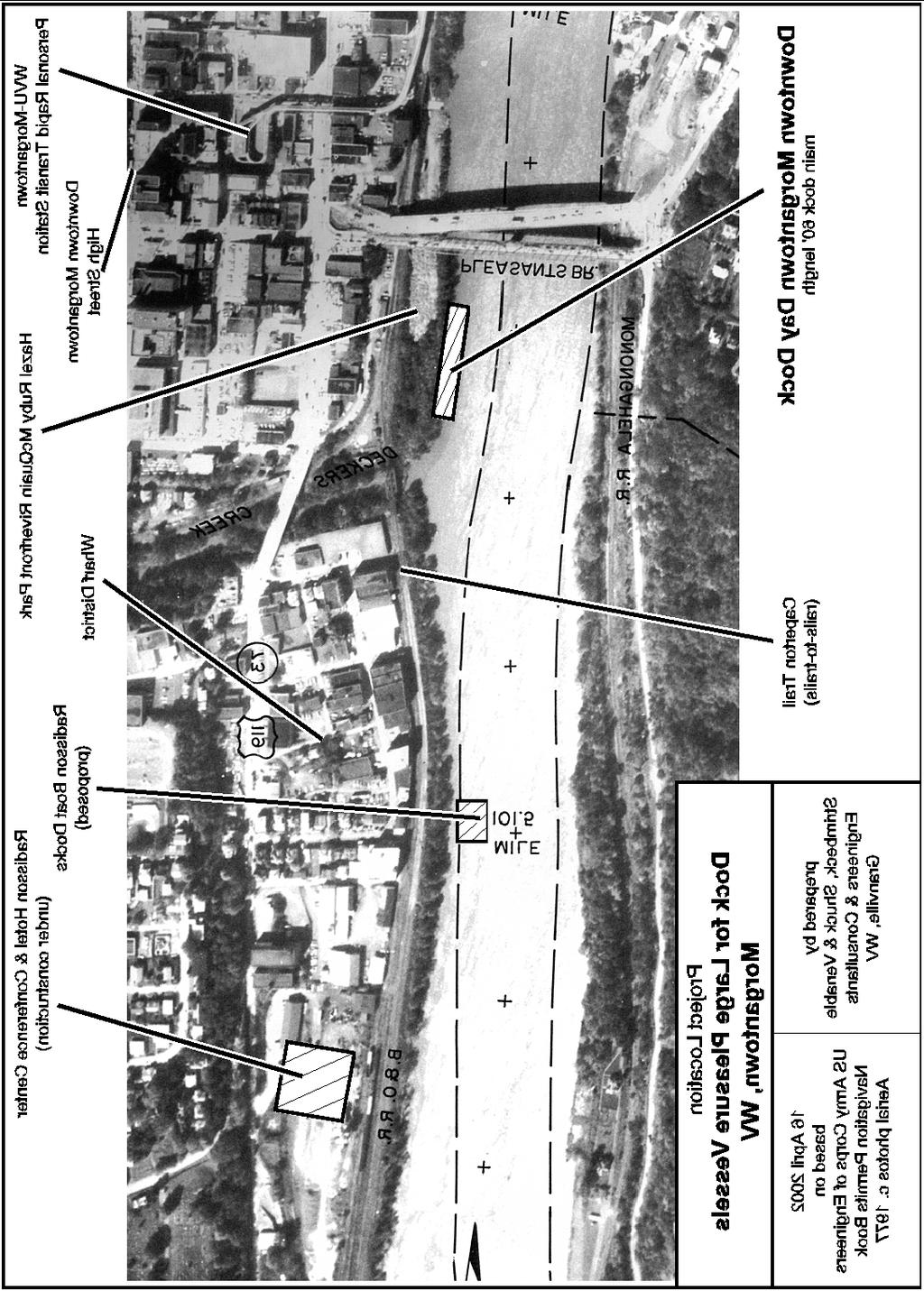
6 River Princess passenger vessel which is seen as a model facility by boaters throughout the region. Star City has discouraged the use of their excellent dock by boaters, whether local or transient. Apparently liability issues have been a primary concern. We recommend that they address this issue, and develop signage which welcomes transient boaters and Star City Dock provides local information. The dock itself is probably adequate in size to meet near-term needs of transients, although extension would not be out of place. Improvement of other facilities should be the focus here, with sanitary needs being the most obvious, followed by electricity for overnight use. Based on the need for connections to sanitary sewer lines, Star City has one of the two locations at which a toilet pump-out station may be easily installed, with Rivesville being the other. The pump-out station can be constructed in conjunction with a planned restroom facility for other park users, and consideration of a shower room should be included in the planning process. Morgantown Riverfront Park The City of Morgantown has a aggressive riverfront development program in place. Hazel Ruby McQuain Riverfront Park has been developed in a former dump site, and adjacent to this the former B&O railroad line has been acquired and converted to a general purpose trail system. The 25 mile Mon River Trail (named the Caperton Trail within city limits) extends along the river from the state line to Prickett s Fort State Park, while the 15 mile Deckers Creek trail runs east to Preston County. The downtown area has many attractions including art galleries, theaters, numerous restaurants varying in cuisine and price, and several antique/collectible and boutique type stores. Access to public transportation is excellent, with the local bus station on the edge of the park, the Greyhound station about a block away, and local taxi service on call. The Downtown station of the West Virginia University-Morgantown Personal Rapid Transit (PRT) system is about three blocks away. The PRT, an international attraction in its own right, is sometimes incorrectly referred to as a monorail. For passenger or crew changes, Morgantown Municipal Airport has commuter connections to Pittsburgh. A massive commercial development is moving forward in the Wharf District on the southern edge of the downtown area. Construction of a Radisson hotel is under way, along with restaurants. A building for the West Virginia Public Theater, which offers summer stock type entertainment, is planned, and it is expected that other entertainment facilities will be developed. A dock at Hazel Ruby McQuain Park (Mile 101) is vitally needed for two reasons: 1. To provide day access to Downtown Morgantown attractions and merchants to boaters from outside our area.


7 2. To support fairs and festivals at the park. These include the Arts & River Festival and the public concerts in addition to the Mason-Dixon Festival. Transient pleasure boats up to 90 feet in length have visited park festivals in the past. During early festivals visiting boats were beached and tied to trees. During park construction old concrete and reinforcing bars which had earlier been dumped on the site were pushed over the beach area. In the process, the usability of this facility went from poor to dangerous. In the recent past the only activity drawing boaters to shore activity has been the Mason-Dixon Festival, and it has relied on borrowing privately owned docks. The docks which have been used in the past are rapidly declining in several safety aspects and the owners are reluctant to continue to provide them. While planned docks in the Wharf District can serve as off-site parking for festival visitors, they will not make boats part of festival activities and Hazardous condition at McQuain Park the backdrop for the show. There is good, but steep, walking access to a gas station, downtown stores, restaurants, hotel, and public transit. The boat ramp at the foot of Walnut Street is the traditional steamboat landing. It can accommodate large vessels for passenger boarding, but has minimal provision for securing lines. It is not useable as a non-trailerable boat mooring. The ramp is useful only for light boats up to about 18 feet in length, and trailer parking is very limited. This site has good road access, although no long-term parking. As noted above, the park is adjacent to the Caperton rail-trail. Restrooms for the trail are under construction, and will be accessible to transient boaters. Portable toilets might be emptied here, although a considerable carry will be required. We would recommend that the new dock be placed behind the stage. This location provides visitors with the Suggested site at McQuain Park allows festivals to best feature boats. most convenient access to the bus terminal and restrooms, provides the more gentle walk to the town center, and
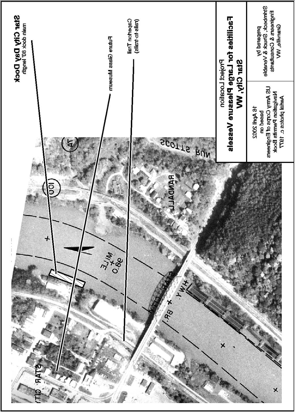
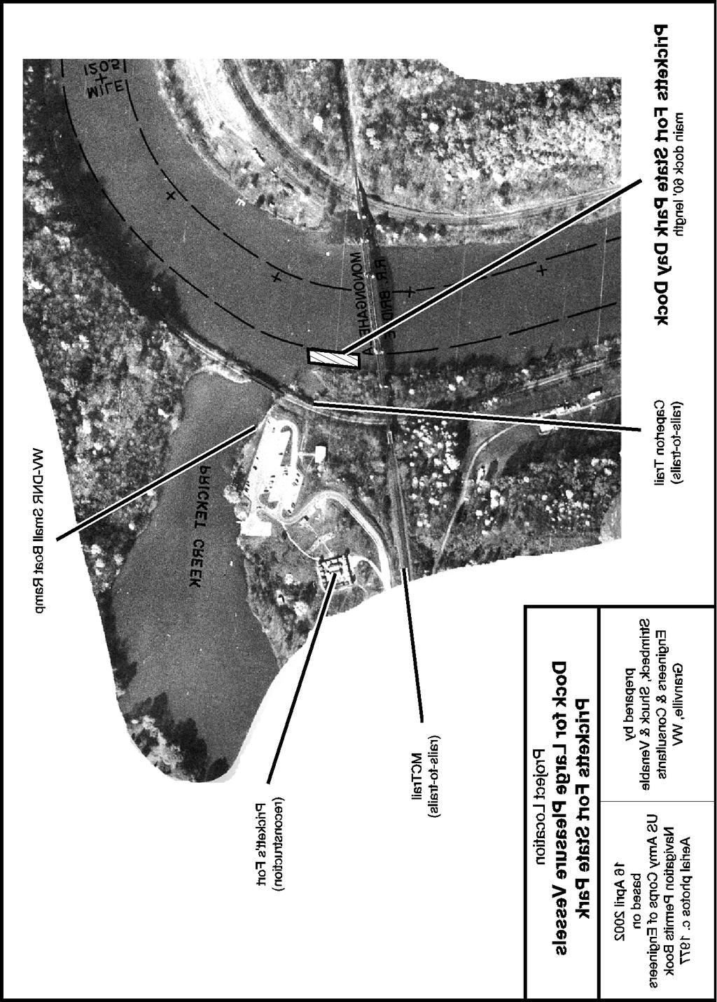
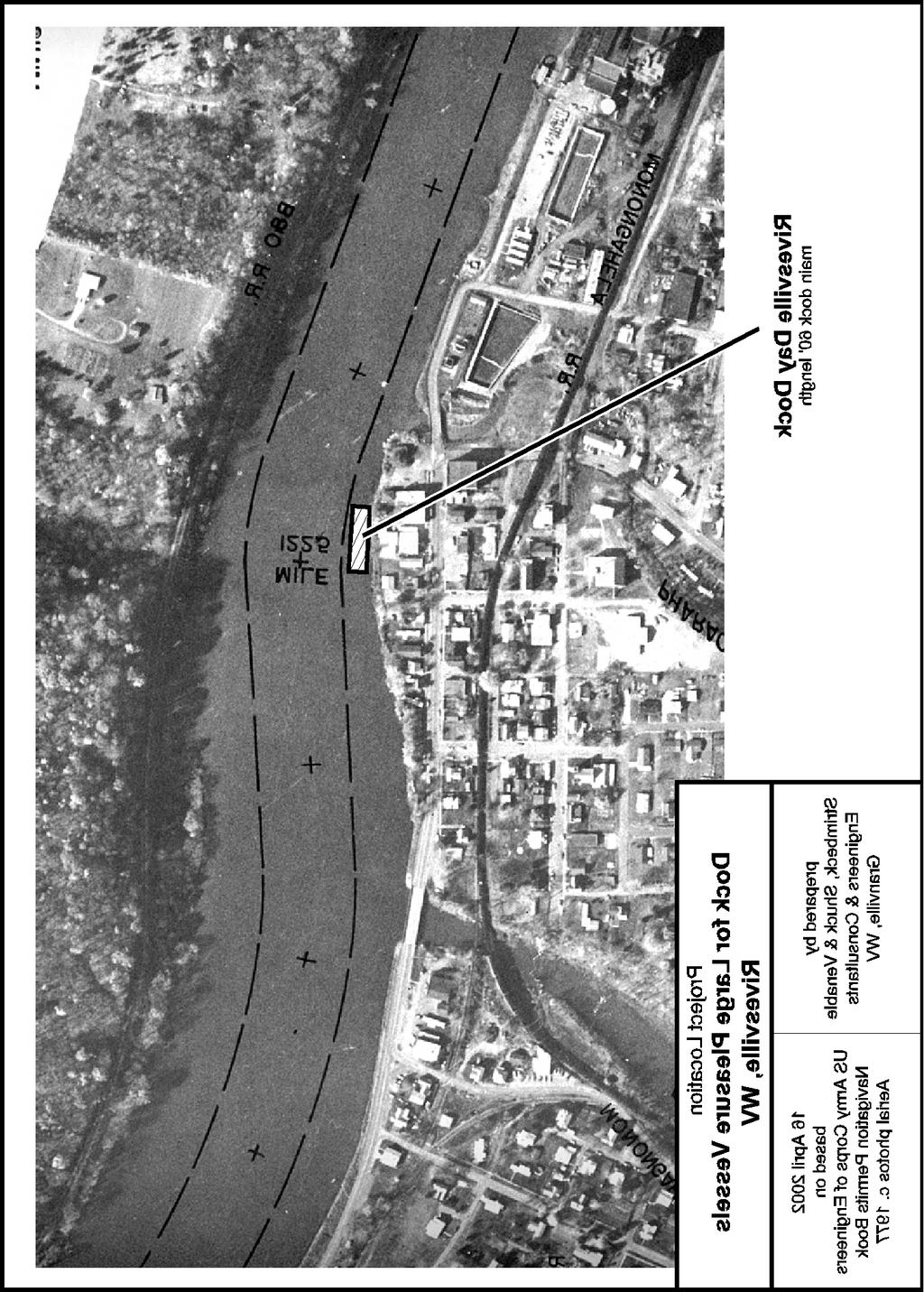
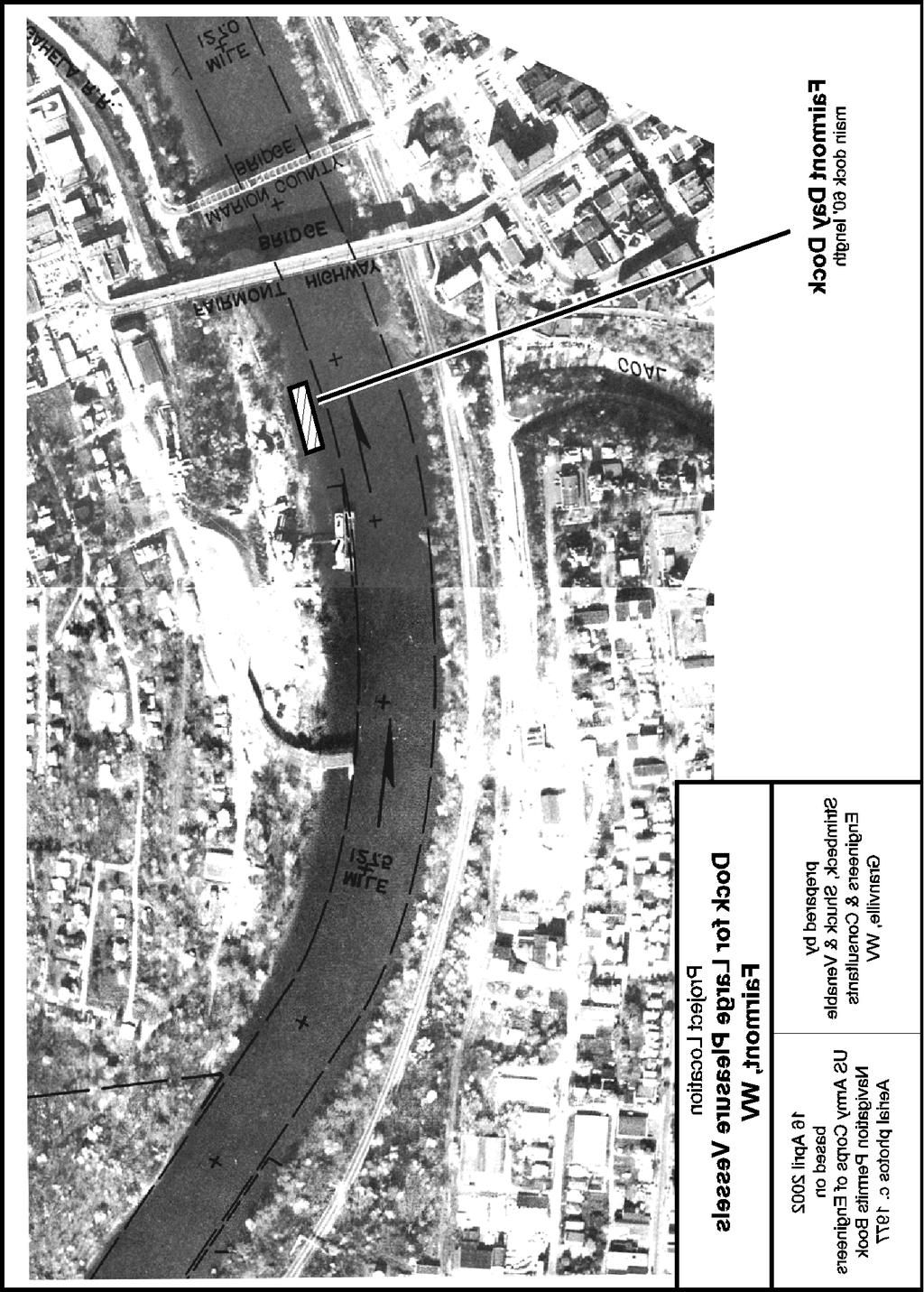
8 Pricketts Fort State Park Pricketts Fort State Park (Mile 121) has the best small boat facilities on the Monongahela within West Virginia. There is a boat ramp with good weekday parking, although more parking is needed. The park has a reconstruction of a frontier fort, and during the summer a blacksmith, weavers, and other craft workers do demonstrations daily. An amphitheater hosts several concerts each summer, and a summer pageant was staged here for several years. There is access to two trails, the long distance, Caperton Trail and the local MACTrail, and further trail extensions will take place if plans for re-use of the rivercrossing railroad bridge can be put into place. There is reasonably good road access to I-79 from the park. Despite the excellent facilities for boats under 20 feet in length, cruising boats are virtually denied use of the park. Large vessels are excluded from entry to the park by the former railroad bridge over Pricketts Creek, as well as by siltation in the basin. The park needs a river dock to allow access to the park s numerous attractions. Rivesville The Town of Rivesville (Mile 122) has several convenience stores, as well as several points of interest. There is considerable private small boat dockage, but no public or large boat accomodation. The town is in the process of constructing a small riverfront park at its Municipal Building. This will include a gazebo and other picnic facilities. A small boat dock is included, but expansion to accommodate non-trailerable vessels should be undertaken. A sanitary pump-out station, as well as a porta-potti disposal point, should be provided at this location to serve the needs of the Opekiska Pool. Fairmont The City of Fairmont (Mile 127) is the county seat of Marion County. It is home to Fairmont State College, and has an assortment of good restaurants. It hosts several community festivals each year, primarily at sites along or near the river. There is good road access to I-79. Fairmont has two potentially good locations for a transient dock. The most desirable is at the current city ramp. The second is on property owned by the WMAC Foundation, a non-profit corporation establish for the improvement of river access. It is a fairly long walk from the ramp across the Million Dollar Bridge to the downtown area, but a supermarket, gas station, restaurants, and other stores are located near the ramp.

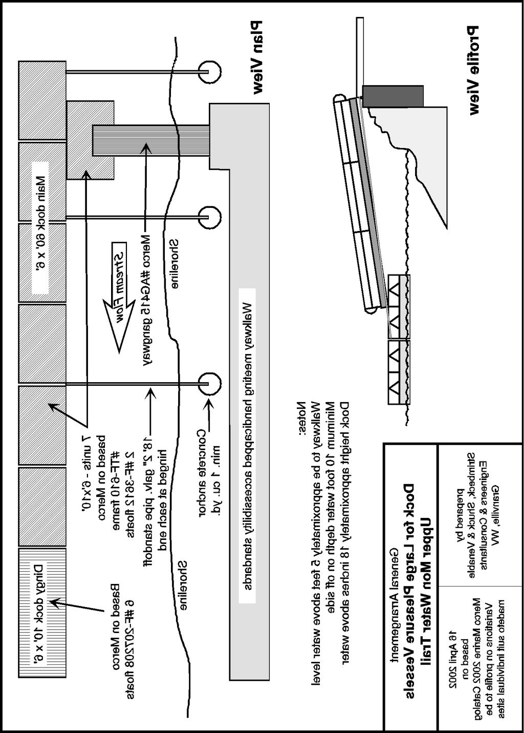
9 Plans For Transient Docks Our preliminary dock designs for transient non-trailerable boats are similar to the one at Star City. These use stock components made by Merco Marine who supplied the units used at Star City, but differ in dimensions and details. The Merco truss frames are of welded steel, hot-dip galvanized after fabrication, and are supported on foam filled plastic tanks manufactured specifically for use as flotation. Our cost estimates are based on the use of Vinyl Deck available through Merco, rather than pressure treated lumber. We suggest a main floating dock 6 feet wide and 60 feet long, with 3 jointed sections and a 16 foot dinghy landing extension. The total parts cost approximately $9000, with a projected total cost of $20,000 per installation including walkways, anchorage points, and assembly. A pre-fabricated Merco aluminum gangway would be used, along with pipe standoffs. River levels on the Upper Mon are generally stabile throughout the boating season, but the occasional rises are rapid and can be of very large magnitude. River fluctuations may be accommodated either by using pilings driven into the river bottom or by the use of standoffs to secure floating docks. We recommend using standoffs since this is the common and successful local practice and because they can be installed from land and therefor do not require the use of a marine contractor. This type of anchorage is shown in the gangway illustration. Because the preliminary work for this study was undertaken during the winter, we have not been able to take depth soundings at each location, but the general bottom profile in the Upper Mon allows vessels with draft up to about eight feet to get within Merco gangway about twenty feet of the bank at almost all points. We are confident that no dredging will be required at any of the proposed sites, and that adjustments in stand-off length and/or minor position changes will allow for any shallows identified in preconstruction soundings. Dock Maintenance - We believe that the proposed docks will require relatively little expense for maintenance during the project life. Primary requirements will be for removal of duck excrement and leaves, modest increases in park rubbish disposal costs, and at some sites, increased brush cutting or lawn mowing. Although most local dock owners have historically removed docks from the river each winter, we think this is probably unnecessary if construction is to the standards suggested. The Tygart and Stonewall Jackson Reservoirs have nearly eliminated the dangers of severe ice jams and flooding. The Star City dock, which is similar in design,


10 has, in fact, remained in place twelve months a year since its installation about six years ago. Sanitary Facilities The information on sanitary facilities provided below is intended as a general cost estimation, rather than as final design selection. We recommend the installation of sewage disposal facilities at two locations: Rivesville, in the Opekiska Pool, and Star City, in the Point Marion Pool. These facilities are needed to serve the existing boating population as well as transients, and income from local boats will help to support the facilities. As previously noted, there are currently no sewage disposal facilities for boats on the Monongahela within West Virginia. At each location there should be a disposal point for portable toilets as well as a pumpout station for boats with holding tanks. For portable toilets we would suggest the KECO Model 300G Kleen-A-Potti. This unit should be installed on the ground, rather than docks, in association with restroom facilities. It could be enclosed and have a coin operated door lock. Cost of this unit is about $1300 plus shipping and installation. We estimate the installed price at $2500. For holding tank pumpout we would suggest the KECO Model 150 Pump-A-Head. This unit should be installed on the docks. We recommend the token operated switch which will permit operation by boat owners at any time. Tokens could be sold at a nearby convenience store as well as through municipal offices. Cost of this unit is about $4200 plus shipping and installation. We estimate the installed price at $5500. Public Dock Information Sign An information sign for a public dock should provide visitors with information on almost all services located within easy walking distance. Information should be keyed to a map of the local area. The following are commonly of interest to cruising boat owners: General emergency services Emergency non-critical medical and dental care
11 Laundromats Beer, wine, and liquor stores Bagged ice Milk and bread Supermarkets Hardware stores Auto parts stores Lumber yards Department stores Restaurants Hotels and motels Museums Antique and collectibles stores Factories with tours or outlet shops While advertising revenues may cover the costs of such a sign, listings should not be restricted to advertisers. If a boat can not find a listing for a critical item, they may move on to another location without patronizing any local businesses. If included, telephone numbers should include the area code. Regular updating of information should be programmed. References C. A. CHANEY, B. S., MARINAS - Recommendations for Design Construction and Maintenance, The National Association of Engine And Boat Manufacturers, Inc., New York, 1939 Keith Wilson, Design Handbook for Recreational Boating and Fishing Facilities, States Organization For Boating Access, Washington, D.C., 1996 Jill D. Murphey, Donald J. Tobaben, Timothy B. Bazley, Lacy E. Nichols, Jr., Lawrence M. Killien, Tom Donek, Operations and Maintenance Program Guidelines for Recreational Boating Facilities, States Organization for Boating Access, Washington, D. C., 1999
12
13
14
15
16
17
18
19
HARBOR INFRASTRUCTURE INVENTORIES Oak Orchard Harbor, New York
 HARBOR INFRASTRUCTURE INVENTORIES Oak Orchard Harbor, New York Harbor Location: Oak Orchard Harbor is located on the southern shore of Lake Ontario at the mouth of Oak Orchard Creek in the village of Point
HARBOR INFRASTRUCTURE INVENTORIES Marquette Harbor, Michigan
 HARBOR INFRASTRUCTURE INVENTORIES Marquette Harbor, Michigan Harbor Location: Marquette Harbor is located in Marquette Bay on the south shore of Lake Superior, 160 miles west of Sault Ste. Marie, MI and
About Rend Lake Marina:
 PRICE GREATLY REDUCED TO $1,495,000.00 For Sale: Rend Lake Marina plus 18 Contiguous Waterfront Acres for Development (Approved by the US Corp of Engineers). Rend Lake Marina 8955 West Dam Lane Benton
HARBOR INFRASTRUCTURE INVENTORIES West Harbor, OH
 HARBOR INFRASTRUCTURE INVENTORIES West Harbor, OH Harbor Location: West Harbor is located on the southern shore of Lake Erie in the township of Catawba Island, OH about 50 miles east of Toledo, OH. Authority:
Fort Hancock Sailing Center
 Response to the National Parks Service Request for Expressions of Interest to Redevelop Historic Structures at Fort Hancock in the Sandy Hook Unit of Gateway National Recreation Area Fort Hancock Sailing
HARBOR INFRASTRUCTURE INVENTORIES Lexington Harbor, Michigan
 HARBOR INFRASTRUCTURE INVENTORIES Lexington Harbor, Michigan Harbor Location: Lexington Harbor is located on the west shore of Lake Huron about 20 miles north of Port Huron, MI. Authority: Rivers & Harbors
HARBOR INFRASTRUCTURE INVENTORIES Cheboygan Harbor, Michigan
 HARBOR INFRASTRUCTURE INVENTORIES Cheboygan Harbor, Michigan Harbor Location: Cheboygan Harbor is located at the mouth of the Cheboygan River, emptying into western Lake Huron approximately 16 miles southeast
HARBOR INFRASTRUCTURE INVENTORIES Port Sanilac Harbor, Michigan
 HARBOR INFRASTRUCTURE INVENTORIES Port Sanilac Harbor, Michigan Harbor Location: Port Sanilac Harbor is located on the west shore of Lake Huron, about 30 miles north of Port Huron, MI. Authority: Rivers
HARBOR INFRASTRUCTURE INVENTORIES Lorain Harbor, Ohio
 HARBOR INFRASTRUCTURE INVENTORIES Lorain Harbor, Ohio Harbor Location: Lorain Harbor is located on the southern shore of Lake Erie in the city of Lorain, OH about 45 miles west of Cleveland, OH. Authority:
MEMORANDUM. Existing Operations. City of Clearwater. Michael Herrman. Date: January 26, Seminole Boat Launch Overview. M&N Job No.
 1509 W. Swann Avenue, Suite 225 Tampa, FL 33606 (813) 258-8818 Fax (813) 258-8525 www.moffattnichol.com MEMORANDUM To: From: City of Clearwater Michael Herrman Date: Subject: Seminole Boat Launch Overview
Redondo Beach Boat Launch Ramp Facility
 Redondo Beach Boat Launch Ramp Facility Feasibility Report for the California Department of Boating and Waterways 2015 Grant Cycle For the City of Redondo Beach Submitted by March 13, 2014 Table of Contents
HANGING ROCK STATE PARK EXPANSION MASTER PLAN PHASE TWO INITIAL CONCEPTS INSTRUCTIONS
 ABOUT THE PROJECT The Master Plan for the Expansion of Hanging Rock State Park will create a vision for the nearly 750 acres of land added to the park in 2014. The new property includes Vade Mecum, which
HARBOR INFRASTRUCTURE INVENTORIES Fairport Harbor, OH
 HARBOR INFRASTRUCTURE INVENTORIES Fairport Harbor, OH Harbor Location: Fairport Harbor is located at the mouth of the Grand River on the southern shore of Lake Erie in the city of Fairport, OH, approximately
5 Year Recreation Plan Proposed Amendment Marina/Harbor/Boat Launch
 5 Year Recreation Plan Proposed Amendment Marina/Harbor/Boat Launch The DNR and Waterways Commission requires certain elements addressing marinas/harbors to be included in a communities 5 Year Recreation
HARBOR INFRASTRUCTURE INVENTORIES Muskegon Harbor, Michigan
 HARBOR INFRASTRUCTURE INVENTORIES Muskegon Harbor, Michigan Harbor Location: Muskegon Harbor is located on the east shore of Lake Michigan, 114 miles northeast of Chicago, IL. Authority: River & Harbor
HARBOR INFRASTRUCTURE INVENTORIES Black Rock Lock & Tonawanda Harbor, NY
 HARBOR INFRASTRUCTURE INVENTORIES Black Rock Lock & Tonawanda Harbor, NY Harbor Location: The Black Rock Channel and Tonawanda Harbor are located along the east side of the Niagara River in the City of
Upper Monongahela River Water Trail
 Upper Monongahela River Water Trail Map and Guide Water trails are recreational waterways on a lake, river, or ocean between specific locations, containing access points and day-use and/or camping sites
TRAVEL PLAN: CENTRAL EUROPEAN UNIVERSITY CAMPUS REDEVELOPMENT PROJECT TRAVEL PLAN. Central European University Campus Redevelopment Project.
 TRAVEL PLAN Central European University Campus Redevelopment Project Page 1 Table of Contents Introduction... 3 Background... 7 Building Users... 7 Transportation in Community Consultation... 7 Summary
Rural Exceptions 1r 100r (Section 240)
") Rural s 1r 100r (Section 240) 1r ME-h, ME1[1r]-h ME2[1r]-h ME3[1r]-h Part 15 Rural s 1r-100r - the holding symbol applies only to the permitted use mineral extraction operation - the holding symbol may
Rural s 1r 100r (Section 240) 1r ME-h, ME1[1r]-h ME2[1r]-h ME3[1r]-h Part 15 Rural s 1r-100r - the holding symbol applies only to the permitted use mineral extraction operation - the holding symbol may
HARBOR INFRASTRUCTURE INVENTORIES Caseville Harbor, Michigan
 HARBOR INFRASTRUCTURE INVENTORIES Caseville Harbor, Michigan Harbor Location: Caseville Harbor is located at the mouth of the Pigeon River on the east shore of Saginaw Bay, about 17 miles southwest of
YOUR BOATING HEADQUARTERS. e GUIDE TO... TOURIST AND CONVENTION BUREAU. Jacksonville and surrounding area... docking facilities,
 YOUR BOATING HEADQUARTERS e GUIDE TO... Jacksonville and surrounding area... docking facilities, navigable waters and vacation entertainment. TOURIST AND CONVENTION BUREAU 307 Hogan Street Jacksonville,
Spearfish Canyon State Park & Bismarck Lake
 Spearfish Canyon State Park & Bismarck Lake Land Exchange Between the U.S. Forest Service and the State of South Dakota July 12, 2016 Background In 2006, the State of South Dakota received title to several
Shark River Municipal Marina 149 South Riverside Drive Neptune, NJ (732)
") Marina Rules and Regulations Boat/PWC owner(s) who hereby agree to lease a boat slip summer/winter storage space and or ramp access at the are subject to the following Marina Rules & Regulations: License/Insurance
Marina Rules and Regulations Boat/PWC owner(s) who hereby agree to lease a boat slip summer/winter storage space and or ramp access at the are subject to the following Marina Rules & Regulations: License/Insurance
Estimated on-the-ground start and end dates: 1 June October 2018
 A. Applicant Information Name of Organization: U.S. Army Corps of Engineers, Carlyle Lake 801 Lake Road, Carlyle, IL 62231 Contact Information: Robert Wilkins, Operations Manager, (618) 594-2484, Robert.Wilkins@usace.army.mil
Life Jacket Drive Manual
 Life Jacket Drive Manual The Sea Tow Foundation received grant funding in 2014 from the Sport Fish Restoration & Boating Trust Fund, administered by the U.S. Coast Guard, to develop a nationwide Life Jacket
San Francisco Bay Area Water Trail Site Description for. Cuttings Wharf
 1 San Francisco Bay Area Water Trail Site Description for Cuttings Wharf Location, Ownership, and Management: Cuttings Wharf is a public boat launch on the Napa River, located at 1230 Cuttings Wharf Road
Port Elgin Harbour Strategic Assessment. Study undertaken by TOURISTICS and Shoreplan Engineering Limited
 Study undertaken by TOURISTICS and Shoreplan Engineering Limited 1 Study included: Review of existing recreational boating facilities in Bruce and Grey Counties An analysis of trends in recreational boating
WHEREAS, the ordinance will not create excessive additional requirements for public facilities and services at public cost.
 ORDINANCE 19-05 AN ORDINANCE OF VALLEY COUNTY, IDAHO, CREATING AN ORDINANCE TO BE ADMINISTERED BY THE VALLEY COUNTY SHERIFF S OFFICE AND TO BE KNOWN AS VALLEY COUNTY WATERWAYS ORDINANCE THAT INCLUDES PAYETTE
Memorandum. To: City Council. cc: Tony Piasecki, City Manager Date: 3/3/2016. Introduction
 I Memorandum 211 To: City Council From: Joe Dusenbury, Harbormaster cc: Tony Piasecki, City Manager Date: 3/3/2016 Re: City Government 101 -The Marina Introduction Staff is presenting this material as
Chapter I: Marine Resources
 NOTE TO READERS: This is a draft of the Kennebunk Comprehensive Plan. The Comprehensive Plan provides us with a description of the town today in a range of categories, and identifies issues and recommendations
BookletChart. Intracoastal Waterway Matecumbe to Grassy Key NOAA Chart A reduced-scale NOAA nautical chart for small boaters
 BookletChart Intracoastal Waterway Matecumbe to Grassy Key NOAA Chart 11449 A reduced-scale NOAA nautical chart for small boaters When possible, use the full-size NOAA chart for navigation. Published by
Washington State Parks comments to the Draft Clallam County Shoreline Master Program Update Consistency Review June 3, 2011
 Washington State Parks comments to the Draft Clallam County Shoreline Master Program Update Consistency Review June 3, 2011 Pg 10 Public access is typically discussed as a requirement placed on facilities
FAYETTE COUNTY. Fayette County Active Transportation Profile REGIONAL ACTIVE TRANSPORTATION PLAN FOR SOUTHWESTERN PENNSYLVANIA
 REGIONAL ACTIVE TRANSPORTATION PLAN FOR SOUTHWESTERN PENNSYLVANIA 1 2 ACTIVE TRANSPORTATION AT A GLANCE Trails + Bike Routes 4 miles 73 miles 130 miles 90 miles Parkland Parkland Trail Off Street Trail
HARBOR INFRASTRUCTURE INVENTORIES Harbor Beach Harbor, Michigan
 HARBOR INFRASTRUCTURE INVENTORIES Harbor Beach Harbor, Michigan Harbor Location: Harbor Beach Harbor is located on the west shore of Lake Huron about 60 miles north of Port Huron, MI. Authority: Rivers
JUNEAU SECOND CHANNEL CROSSING WATERWAY USER SURVEY RESULTS
 JUNEAU SECOND CHANNEL CROSSING WATERWAY USER SURVEY RESULTS PREPARED FOR: HDR Alaska, Inc. PREPARED BY: Juneau Anchorage December 2003 TABLE OF CONTENTS Executive Summary...1 Introduction and Methodology...2
CANDLEWOOD SHORES TAX DISTRICT ORDINANCE GOVERNING USE OF THE CSTD RECREATION AREAS
 BE IT ORDAINED THAT: Section 1 - TITLE: This Ordinance shall be known and may be cited as the Recreation Area Use Ordinance of the Candlewood Shores Tax District (CSTD). Section 2 - PURPOSE: The purpose
Marina Marketing as a Worthwhile Investment by Amos Raviv
 Marina Marketing as a Worthwhile Investment by Amos Raviv My store begins in a small Mediterranean country called Israel, which boasts 180 kilometers of straight sandy beaches, avid beachgoers. and also
Coastal and marine recreation in New England is ingrained in the region s economic and
 RECREATION Coastal and marine recreation in New England is ingrained in the region s economic and social fabric. Recreation on the ocean and coast includes many of New Englanders most time-honored and
RLRC COMMUNITIES EAST GRAND FORKS AREA CHARACTER THE RED LAKE RIVER & THE RED RIVER OF THE NORTH CONFLUENCE EAGLE POINT BOAT LAUNCH DESIGN
 AREA CHARACTER THE RED LAKE RIVER & THE RED RIVER OF THE NORTH CONFLUENCE EAGLE POINT BOAT LAUNCH DESIGN DESIGN DETAILS 135 AREA CHARACTER East Grand Forks a city of 7,501 people is located across the
DRAFT. Table of Contents. Background
 Douglas County Table of Contents Existing Infrastructure 86 Funding 89 Policy and Program Recommendations 90 Infrastructure Recommendations 92 Conclusion 95 Background Home to 4,500 residents and Baker
ONTARIO BY BIKE NETWORK
 Business Name: ONTARIO BY BIKE NETWORK Participant Registration Registration is also available and preferred on-line: www.ontariobybike.ca/join-the-network Business Category: Accommodations (incl. Campgrounds)
ECONOMIC DEVELOPMENT ELEMENT
 ECONOMIC DEVELOPMENT ELEMENT Background The Economic Development Element considers labor force and labor force characteristics, employment by place of work and residence, and analysis of the community
EXECUTIVE SUMMARY: TRANSIT-ORIENTED DEVELOPMENT IN SMITHS FALLS, ONTARIO; A COMPARISON BETWEEN TWO SITES
 EECUTIVE SUMMARY: TRANSIT-ORIENTED DEVELOPMENT IN SMITHS FALLS, ONTARIO; A COMPARISON BETWEEN TWO SITES Topic and Purpose In 2007, the Mayor of Ottawa s Task Force on Transportation suggested adding a
MARINE INCIDENT SUMMIT INCIDENT BRIEFS FROM THE 2ND & 3RD QUARTERS OF CY 2014
 MARINE INCIDENT SUMMIT INCIDENT BRIEFS FROM THE 2ND & 3RD QUARTERS OF CY 2014 MARINE SAFETY UNIT PITTSBURGH Office: (412) 644-5808 Fax (412) 644-3479 Pittsburgh2692@uscg.mil Disclaimer: This document is
FINAL EXPRESS TERMS FOR PROPOSED BUILDING STANDARDS OF THE CALIFORNIA DEPARTMENT OF PUBLIC HELATH
 FINAL EXPRESS TERMS FOR PROPOSED BUILDING STANDARDS OF THE CALIFORNIA DEPARTMENT OF PUBLIC HELATH REGARDING PROPOSED CHANGES TO THE CALIFORNIA BUILDING STANDARDS, ADMINISTRATIVE CODE CALIFORNIA CODE OF
ROYAL VANCOUVER YACHT CLUB
 ROYAL VANCOUVER YACHT CLUB PROPOSED EXPANSION PROJECT NAVIGATION CHANNEL DESIGN COAL HARBOUR Prepared for: Royal Vancouver Yacht Club Prepared by: Typlan Consulting Ltd. March 2016 Page 1 of 17 March 23,
Recreational Boating Definitions (2006)
") Page 1 of 5 Recreational Boating Definitions (2006) Vessels, Boats and Craft Vessels include every description of watercraft, including non-displacement craft and seaplanes, used or capable of being used
Page 1 of 5 Recreational Boating Definitions (2006) Vessels, Boats and Craft Vessels include every description of watercraft, including non-displacement craft and seaplanes, used or capable of being used
U.S. Army Corps of Engineers
 A. U.S. Army Corps of Engineers Kevin Parsons, Natural Resources Specialist 500 Resource Management Drive West Point, GA 31833 706-645-2937 Kevin.M.Parsons@usace.army.mil B. Underwater Structure Enhancement
Encouragement. Chapter 4. Education Encouragement Enforcement Engineering & Facilities Evaluation & Planning. Encouragement Chapter 4
 Encouragement Education Encouragement Enforcement Engineering & Facilities Evaluation & Planning Photo above: Children show off their ribbons at the Tour de Virginia Beach. Virginia Beach Bikeways and
Superyacht Seattle. Moorage Options
 Superyacht Seattle Moorage Options Terminal91 Terminal 91 2001 W Garfield St Seattle, WA 98199 206.787.3751 seaops@portseattle.org Terminal 91 is a secure facility located on Elliott Bay, at the north
Alley OUR BUSINESS SUMMARY
 Alley OUR BUSINESS SUMMARY Table of Contents Introduction to Strike Bowling Alley 1 Our Organizational Model 2 Revenue Streams 3 Personnel & Job Creation 4 Location Selection & New Construction 5 Bowling
GENERAL CODE PROVISIONS TABLE OF CONTENTS
 GENERAL CODE PROVISIONS CHAPTER 1 CODE OF ORDINANCES... 1 CHAPTER 2 CHARTER... 9 CHAPTER 3 BOUNDARIES... 11 CHAPTER 4 MUNICIPAL INFRACTIONS... 17 CHAPTER 5 OPERATING PROCEDURES... 25 CHAPTER 6 CITY ELECTIONS...
REDEVELOPMENT OPPORTUNITY! FOR SALE
 SALE PRICE: Contact Agent LOT SIZE: 0.31 Acres BUILDING SIZE: 2,830 SF YEAR BUILT: 1906 ZONING: CBD Central Business District CROSS STREETS: 2nd Street South PROPERTY OVERVIEW This offering is for the
Planning of Major Recreational Boating Facilities at Shell Cove Boat Harbour
 Planning of Major Recreational Boating Facilities at Shell Cove Boat Harbour B Morgan 1, Deborah Lam 1, Glenn Colquhoun 2 1 Advisian, Sydney, NSW 2 Frasers Property Australia, Shell Cove, NSW Abstract
Site Improvements
 Sections Included In This Standard: 1.1 Bicycle Facilities 1.2 Guardrails 1.3 Parking Bumpers 1.4 Traffic Signage 1.5 Traffic Signals 1.6 Traffic Impact Studies 1.7 Vision Triangle 1.8 Bus Stop Shelters
MARKET STUDY FOR BOATING ON THE MINNESOTA WATERS OF LAKE SUPERIOR
 MARKET STUDY FOR BOATING ON THE MINNESOTA WATERS OF LAKE SUPERIOR MARKET STUDY FOR BOATING ON THE MINNESOTA WATERS OF LAKE SUPERIOR CANADA Minnesota Apostle Islands Isle Royale Lake Superior Michigan Wisconsin
Business and Marketing Plan Overview
 Business and Marketing Plan Overview GL Sports Entertainment 813.484.2842 curt@glsportsentertainment.com OVERVIEW: The Pasco County full-service multisport complex will be Florida's premier year-round
DRAFT. October 17, 2014 File No Mr. Brendhan Zubricki Town Administrator Essex Town Hall 30 Martin Street Essex, MA.
 GZA GeoEnvironmental, Inc. Engineers and Scientists October 17, 2014 File No. 18.0171857.00 Mr. Brendhan Zubricki Town Administrator Essex Town Hall 30 Martin Street Essex, MA. 01929 DRAFT Re: Essex River
2012 Laser North American Championships July 19-22, 2012 Columbia Gorge Racing Association, Cascade Locks, Oregon
 2012 Laser North American Championships July 19-22, 2012 Columbia Gorge Racing Association, Cascade Locks, Oregon Notice of Race 1. Rules 1.1. The regatta will be governed by the rules as defined by The
SEA LIFE Brighton: Access Statement May 2015
 SEA LIFE Brighton: Access Statement May 2015 INTRODUCTION The SEA LIFE Centre is situated in the heart of Brighton right next to Brighton Pier. It can be seen from the main route into Brighton; London
Ketchikan Harbors Thomas Basin and Bar Point Harbor
 Ketchikan Harbors Thomas Basin and Bar Point Harbor Condition of Improvements 30 December 2014 Thomas Basin & Bar Point Harbors Ketchikan, Alaska (CWIS No. 000631 & 087071) Authorization (1) Rivers and
Potomac Fever. Captain Bill Washington. President, CAPCA
 Potomac Fever by Captain Bill Washington President, CAPCA Unlike most of you, I consider the Potomac River around Washington, DC, to be my primary cruising ground. As mundane as this may sound, the area
LAKE BLUFF PARK DISTRICT BLAIR PARK SWIMMING POOL Questions and Answers OVERVIEW
 LAKE BLUFF PARK DISTRICT BLAIR PARK SWIMMING POOL Questions and Answers www.lakebluffparks.org OVERVIEW Q: How did the community rate the pool on the Community Wide survey? A: The top three highest rated
er North American Championships
 2015 29er North American Championships July 17-19, 2015 Columbia Gorge Racing Association Cascade Locks, Oregon NOTICE OF RACE 1. RULES 1.1. The regatta will be governed by the rules as defined in The
STRATEGIC PLANNING FOR DEVELOPMENT OF THE OREGON SHORT LINE TERMINUS HISTORIC DISTRICT
 STRATEGIC PLANNING FOR DEVELOPMENT OF THE OREGON SHORT LINE TERMINUS HISTORIC DISTRICT & AN EXECUTIVE SUMMARY OF THE HEART OF WEST YELLOWSTONE CONCEPTUAL PLANNING REPORT November 2004 PREPARED BY The Portico
County of Santa Barbara Permit Option Analysis Goleta Beach JULY 13, 2017
 County of Santa Barbara Permit Option Analysis Goleta Beach JULY 13, 2017 Introduction 2 Goleta Beach Park welcomes 1.5 million visitors annually Amenities include: Picnic Areas and Group Areas w/bbqs
Issues facing this region include the status of the Sluice Creek tide gates, various tidal wetlands, and locations of public access:
 5.6 Guilford Point to Madison Town Line Existing Resources This region extends from Guilford Point to the Madison town line. Named places include Grass Island and the East River. Residential, commercial,
Parks Canada + Boating = A Beautiful Thing! Darlene Upton Parks Canada
 Parks Canada + Boating = A Beautiful Thing! Darlene Upton Parks Canada 1 5 NATIONAL PARKS 2 37 NATIONAL HISTORIC SITES 1 WORLD HERITAGE SITE NATIONAL URBAN PARK 2 3 The Parks Canada Boating Offer 4 Partners
Feasibility Study for Intermodal Facility in Anchorage, Alaska
 Feasibility Study for Intermodal Facility in Anchorage, Alaska Jeanne Bowie, Randy Kinney Abstract The Dimond Transit Center, operated by People Mover, is located in south Anchorage at the Dimond Center,
Obey Creek PEDESTRIAN CIRCULATION EAST WEST PARTNERS PEDESTRIAN CIRCULATION CREEK SIDE LANE SLIP STREET SCOTT MURRAY MAIN STREETS EAST/WEST
 THE VILLAGE AT PEDESTRIAN CIRCULATION MAIN STREETS NORTH/SOUTH MAIN STREETS EAST/WEST SLIP STREET CREEK SIDE LANE PEDESTRIAN CIRCULATION DESCRIPTION: Circulation through the downtown of is organized by
New Orleans Municipal Yacht Harbor
 New Orleans Municipal Yacht Harbor Marina Schematic Design Update 601 Poydras St., Suite 1860 New Orleans, LA, 70130 504-648-3560 Post-Katrina Municipal Yacht Harbor: Introduction The MYH was an approximate
Economic Impact Analysis BOONE DOCKS RESORT AND MARINA, LLC
 Economic Impact Analysis BOONE DOCKS RESORT AND MARINA, LLC Analysis conducted using the on-line Boating Economic Impact Model developed by Drs. Ed Mahoney (mahoneye@msu.edu), Dan Stynes (stynes@msu.edu)
2018 Beach Preservation Project Information
 QUICK FACTS Beach Renourishment to begin late April 2018 o U.S. Army Corps of Engineers project o Project Area: 8 th St. E. to end of E. Ashley Ave. o Project Length: 2 miles o Cost: $10,900,000 o Funding:
Storm Preparedness Plan for Manchester, Massachusetts Issued by the Manchester Harbormaster Department. A.
 Manchester-by-the-Sea Harbormaster Harbormaster 10 CENTRAL ST. MANCHESTER, MASSACHUSETTS 01944-1399 OFFICE (978)526-7832 CELL (978)473-2520 FAX (978)526-2001 HARBORMASTER@MANCHESTER.MA.US. Storm Preparedness
VISITING BOATS INFORMATION
 VISITING BOATS INFORMATION 2017 Seaham Harbour Marina is a joint venture between the Victoria Group and Durham County Council Marina Management Unit 10, The Waterside Seaham Harbour Marina, Seaham County
Crawford Reservoir. FISH SURVEY AND MANAGEMENT INFORMATION Eric Gardunio, Fish Biologist Montrose Service Center
 FISH SURVEY AND MANAGEMENT INFORMATION General Information: Crawford Reservoir is a popular fishery that provides angling opportunity for yellow perch, channel catfish, northern pike, rainbow trout, black
AGM Paul s Cove The Wolves
 AGM 2016 Paul s Cove The Wolves AGENDA INTRODUCTORY REMARKS CALL FOR ADDITIONS AND APPROVAL OF THE AGENDA MINUTES OF ANNUAL GENERAL MEETING NOVEMBER 2015 COMMITTEE REPORTS: COMMODORE S REPORT ANDREW JEFFERIES
CITY OF NEWPORT BEACH HARBOR COMMISSION STAFF REPORT
 CITY OF NEWPORT BEACH HARBOR COMMISSION STAFF REPORT Agenda Item No. 2 TO: FROM: SUBJECT: HARBOR COMMISSION Harbor Resources Division (City Manager's Office) Chris Miller, Harbor Resources Supervisor,
Coastal Harbors and Waterways, NC (Shallow Draft Navigation) (O&M)
 (O&M)") Coastal Harbors and Waterways, NC (Shallow Draft Navigation) (O&M) Shallow draft coastal harbors include a subsistence harbor at Silver Lake CONGRESSIONAL DISTRICT: NC 3, 7 DATE: 23 April 2018 1. AUTHORIZATION:
Coastal Harbors and Waterways, NC (Shallow Draft Navigation) (O&M) Shallow draft coastal harbors include a subsistence harbor at Silver Lake CONGRESSIONAL DISTRICT: NC 3, 7 DATE: 23 April 2018 1. AUTHORIZATION:
Canoe/Kayak Launch Sites and Accessibility
 Canoe/Kayak Launch Sites and Accessibility Doug Alderson, Paddling Trails Coordinator Division of Recreation and Parks Office of Greenways and Trails Each potential access site on a river, lake or ocean
APPENDIX D REAL ESTATE PLAN
 NAVIGATION IMPROVEMENTS SITKA HARBOR, ALASKA CHANNEL ROCK BREAKWATERS DRAFT DEFICIENCY CORRECTION EVALUATION REPORT APPENDIX D REAL ESTATE PLAN JANUARY 2011 REAL ESTATE PLAN FOR SITKA HARBOR, ALASKA CHANNEL
RESEARCH Massachusetts Recreational Boater Survey. Project Summary
 Coastal and Marine Spatial Planning RESEARCH Project Summary 2010 Massachusetts Recreational Boater Survey The 2010 Massachusetts Recreational Boater Survey gathered spatial and economic data relating
Page 1. CALL MEETING TO ORDER 2. DISCUSSION ITEMS
 1. CALL MEETING TO ORDER 2. DISCUSSION ITEMS CAROLINA BEACH Town Council Workshop Meeting Agenda Tuesday, July 25, 2017 @ 9:00 AM Council Chambers 1121 N. Lake Park Boulevard Carolina Beach, NC 28428 a.
2760 Cameron Road, West Kelowna, BC V1Z 2T6 Tel.: ; Fax:
 Hello West Kelowna Resident! You have been randomly selected to participate in the City of West Kelowna s Annual Citizens Survey. This anonymous, statistically-accurate survey provides West Kelowna Council
Strategies to Promote the Availability of Affordable Healthy Food and Beverages
 Strategies to Promote the Availability of Affordable Healthy Food and Beverages CDC Recommended Strategies and Measurements Strategy #1: Communities Should Increase Availability of Healthier Food and Beverage
WALK- AND bike-friendly TURLOCK
 WALK- AND bike-friendly TURLOCK Ideas to Encourage Walking and Biking Benefits to the COMMUNITY Get Connected People who walk and bike have many more opportunities for casual interactions with friends
Request for Proposals L4865 The Pier 25 Marine Facility Concession in Hudson River Park (RFP) Questions & Answers.
 Questions & Answers.") Request for Proposals L4865 The Pier 25 Marine Facility Concession in Hudson River Park (RFP) Questions & Answers January 16, 2018 Q1: What is the current serviceability status of the moorings? A: All
Request for Proposals L4865 The Pier 25 Marine Facility Concession in Hudson River Park (RFP) Questions & Answers January 16, 2018 Q1: What is the current serviceability status of the moorings? A: All
CARMACKS. Summary of Facilities: Community Hall Curling Rink Gymnasium Swimming Pool Outdoor Rink Playground/Gazebo Boardwalk Golf Course
 CARMACKS Yukon Government Community Services - 1 - March 2006 Summary of Facilities: Community Hall Curling Rink Gymnasium Swimming Pool Outdoor Rink Playground/Gazebo Boardwalk Golf Course CARMACKS Boardwalk
Burrard Bridge Civic Marina. Class B Marina (No Liveaboard Facilities) A Prime Location in the Heart of Downtown Vancouver
 A Prime Location in the Heart of Downtown Vancouver") Features 1661 443 Water Moorage Slips (21 ft to 38 ft) 149 Land Storage Berths 12 Rowing Compounds BURRARD BRIDGE 36 Canoe/Kayak Racks 1601 Class B Marina (No Liveaboard Facilities) A Prime Location in
Features 1661 443 Water Moorage Slips (21 ft to 38 ft) 149 Land Storage Berths 12 Rowing Compounds BURRARD BRIDGE 36 Canoe/Kayak Racks 1601 Class B Marina (No Liveaboard Facilities) A Prime Location in
1999 On-Board Sacramento Regional Transit District Survey
 SACOG-00-009 1999 On-Board Sacramento Regional Transit District Survey June 2000 Sacramento Area Council of Governments 1999 On-Board Sacramento Regional Transit District Survey June 2000 Table of Contents
LEED Pilot Credit Library
 Pilot Credit 13: Bicycle Network, Storage, and Shower Rooms Applicable Rating Systems >> Requirements >> Submittals >> Additional Questions >> Background Information >> Changes >> Applicable Rating Systems
City of Lima Bicycle Parking Guide
 City of Lima Bicycle Parking Guide The Allen County Bike and Pedestrian Task Force is a community organization that is Allen County s voice for safe places to walk, bike and be active in Allen County Keeping
PINECREST LAKE SHORELINE MANAGEMENT PLAN Draft April 3, 2012
 !"#$%&'()!(*#%$+"$', TALKING POINTS PINECREST LAKE SHORELINE MANAGEMENT PLAN Draft April 3, 2012 Friends of Pinecrest has reviewed the Shoreline Management Plan developed by PG&E for the Forest Service,
o n - m o t o r i z e d transportation is an overlooked element that can greatly enhance the overall quality of life for the community s residents.
 N o n - m o t o r i z e d transportation is an overlooked element that can greatly enhance the overall quality of life for the community s residents. 84 Transportation CHAPTER 11 INTRODUCTION Transportation
Detailed Itinerary. Park Admission Fee: $6.00 per vehicle. Limit 2-8 people per vehicle. $4.00 Single occupant vehicle. $2.00 extra passengers
 Detailed Itinerary Pensacola, Florida (Days 1-3) Dive the Mighty O (USS Oriskany) and shore dives at Fort Pickens Jetties and other sites, see attached list of Pensacola shore dives. June 8, 2013 Travel
SINGLE LONG TERM MOORING AGAINST PRIVATE RESIDENTIAL LAND
 SINGLE LONG TERM MOORING AGAINST PRIVATE RESIDENTIAL LAND The Canal & River Trust is the owner of the canal bed and permission is needed for the exclusive right to occupy water space as a home mooring.
A LIFESTYLE FOR A LIFETIME
 Membership A LIFESTYLE FOR A LIFETIME Located in the heart of some of nature s most masterful handiwork, Two Rivers Country Club is full of all the things that make life special an inviting atmosphere,
TOWN OF WESTPORT WHARFAGE DEPARTMENT DOCK RULES AND REGULATIONS INTRODUCTION
 TOWN OF WESTPORT WHARFAGE DEPARTMENT DOCK RULES AND REGULATIONS INTRODUCTION William Almy on March 16, 1936 sold to the Town of Westport a certain wharf and the buildings thereon, standing with the adjoining
Sport Fishing Expenditures and Economic Impacts on Public Lands in Oregon
 Sport Fishing Expenditures and Economic Impacts on Public Lands in Oregon For: Northwest Sportfishing Industry Association By: Southwick Associates October 2013 PO Box 6435 Fernandina Beach, FL32035 Tel
Regatta Venue Information
 Regatta Venue Information For PORT DALRYMPLE YACHT CLUB At Beauty Point, Tasmania www.pdyc.yachting.org.au Contents Introduction Background Championship Headquarters Location of Host Club Race Area Maps