Bottom habitat mapping in Plateliai lake applying remote underwater video techniques
|
|
|
- Beverly McKinney
- 5 years ago
- Views:
Transcription
1 Bottom habitat mapping in Plateliai lake applying remote underwater video techniques Darius Daunys 1,3 Šarūnas Navickas 2, Modesta Riaukaitė 1, Martynas Bučas 1,3, Aleksej Šaškov 3, Andrius Šiaulys 1,3 Department of Ecology, Klaipeda University Department of Geosciences, Klaipeda University Coastal Research and Planning Institute, Klaipeda University


2 Benthic habitat: regularly occurring bottom areas (typically at least 10 m 2 ) with relatively uniform geomorphology and corresponding biological features (aquatic plants, animals, traces, etc.). Terms: Habitat = Biotope Advantages: - easily detectable; - in comparison to water column characteristics, relatively stable over time; - integrate main environmental and biological features.


3 Overall aim: to define potential sites and parameters for monitoring of benthic habitats in the lake Plateliai Currently: - How many main benthic habitats? - What are the main features of the benthic habitats? - Which benthic habitats are the most widespread, and which ones are rare and valuable? - Are remote sensing techniques applicable in detection of key habitat features?


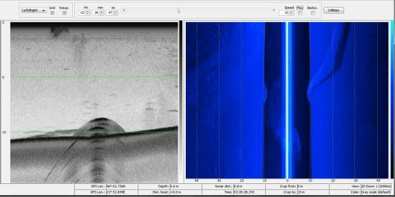
4 Methods: three main techniques: acoustic sonar, macrophyte sampling, underwater recording. 8 sampling transects, mostly in depths down to 10 m; 4 hours of underwater video data; 13 hours of acoustic data.
 and acoustic sonar Three engines")
 Acoustic")

 Cable (50 m) Depth Bottom topography")
5 Remotely operated underwater video system (ROV) and acoustic sonar Three engines Buoyancy regulators Two cameras (navigation, recording) Acoustic positioning Depth sensor Light Control unit (speed, distance above bottom, view wangle, zoom etc.) Cable (50 m) Depth Bottom topography Substrate type Small scale distribution in the area below the ship
6 Inventory of macrophytes: 1995 (Sinkevičienė, Stepanavičienė, 1996) 2012 (this study) Submerged phanerogams Horsetails (Equisetum sp.) 1 1 Aquatic mosses 2 3 Stoneworts (Charophytes) 9 8 Macroscopic green algae 1 4 TOTAL: 30 28


7 Habitat Directive Annex 1 Habitat types Natural eutrophic lakes with Magnopotamion or Hydrocharition type vegetation Characteristic species: Aldrovanda vesiculosa Hydrilla verticillata Hydrocharis morsus-ranae Lemna minor Lemna trisulca Myriophyllum verticillatum Potamogeton lucens Potamogeton perfoliatus Potamogeton praelongus Potamogeton angustifolius Potamogeton salicifolius Spirodela polyrhiza Stratiotes aloides Utricularia vulgaris Utricularia vulgaris Paprastasis skendenis


8 Habitat Directive Annex 1 Habitat types Hard oligo-mesotrophic waters with benthic vegetation of Chara spp. Characteristic species: Chara aspera Chara contraria Chara filiformis Chara rudis Chara strigosa Chara tomentosa Lychnothamnus barbatus Nitella flexilis Nitella opaca Nitellopsis obtusa Nitellopsis obtusa Nitella opaca
: Approx.")


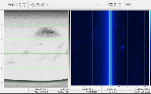
9 Main benthic habitats (ROV data analysis): Approx. 110 bottom types determined according to 17 physical and biological features 1. Muddy bottoms with zebra mussels 2. Muddy bottoms covered by shell deposits 3. Muddy bottom with free floating macroalgae (and freshwater sponges) 4. Charophyte dominated bottoms


10 Video mosaics analysis of benthic habitats at larger spatial scales:


11 Closer look at Chara dominated bottoms: habitat sub-types 1. Chara dominated bottoms with colonies of zebra mussels. 2. Chara dominated bottoms with Potamogeton. 3. Densely vegetated Chara bottoms.
12 Distribution of Chara dominated bottoms: Chara dominated bottoms with colonies of zebra mussels. Chara dominated bottoms with Potamogeton. Densely vegetated Chara bottoms. Not found

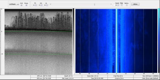
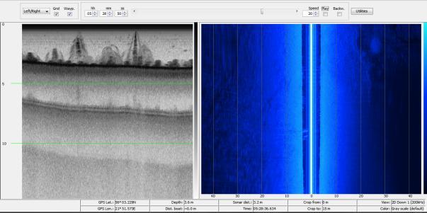
13 Acoustics: bottom geomorphology and vegetation types

14 Distribution/area of Chara dominated bottoms:
2015 Macrophyte Survey Results
 Invasive Macrophyte Survey Pilot 2015 2015 Macrophyte Survey Results COMPLETED WITH SUPPORT FROM: Acknowledgments The Invasive Plant Monitoring Program was made possible through the support of Alberta
Mud Bay SLELO-PRISM Water Chestnut & Hydrilla Surveillance 2012
 St. Lawrence Eastern Lake Ontario Partnership for Regional Invasive Species Management Mud Bay Water Chestnut & Hydrilla Surveillance 2012 June 27 th (Water Chestnut) & August 2 (Hydrilla), 2012 Figure
Starry Stonewort. A new aquatic invader in Wisconsin. Michelle Nault Wisconsin Department of Natural Resources
 Starry Stonewort A new aquatic invader in Wisconsin Michelle Nault Wisconsin Department of Natural Resources Michelle.Nault@Wisconsin.gov Photo: Paul Skawinski What is starry stonewort? Starry stonewort
Starry Stonewort in Silver Lake Washington County, WI BRAD STECKART AIS COORDINATOR FOR WASHINGTON AND WAUKESHA COUNTIES
 Starry Stonewort in Silver Lake Washington County, WI BRAD STECKART AIS COORDINATOR FOR WASHINGTON AND WAUKESHA COUNTIES Brad Steckart -AIS coordinator for Washington and Waukesha Counties -Graduated from
Aquatic Plant Point-Intercept Survey for Pike Lake, Scott County, Minnesota
 Campers on Pike Lake, Scott County, Minnesota, 2015 Aquatic Plant Point-Intercept Survey for Pike Lake, Scott County, Minnesota [Plant Survey Conducted August 24, 2015] Prepared for: Prior Lake/Spring
Kerr Lake Vegetation Survey. October November Report submitted by NC State University. Background
 Kerr Lake Vegetation Survey October November 2012 Report submitted by NC State University Background Hydrilla (Hydrilla verticillata) is a non-native invasive submersed aquatic plant. This plant was first
BIODIVERSITY OF MACROPHYTE VEGETATION FROM LAKE PRESPA, LAKE OHRID AND LAKE SKADAR
 BIODIVERSITY OF MACROPHYTE VEGETATION FROM LAKE PRESPA, LAKE OHRID AND LAKE SKADAR M. Talevska 1, D. Petrovic 2, D. Milosevic 2, T. Talevski 1, D. Maric 2 and A. Talevska 3 1 Hidrobiological Institute
Nearshore Habitat Mapping in Puget Sound Using Side Scan Sonar and Underwater Video
 Nearshore Habitat Mapping in Puget Sound Using Side Scan Sonar and Underwater Video Dana Woodruff, Paul Farley, Amy Borde, John Southard, Ron Thom Battelle Marine Sciences Laboratory Jim Norris Marine
Aquatic Plants of the Three Lakes
 Aquatic Plants of the Three Lakes Chris Doyle, CLM Senior Aquatic Biologist/Water Quality Program Supervisor Allied Biological, Inc. 580 Rockport Road Hackettstown, NJ 07840 Phone: 908-850-0303 E-mail:
Appendix A. Depth limits of selected species
 Appendix A. Depth limits of selected species Perennial macroalgae, stoneworts and higher plant taxa observed in more than 50 transects were selected for depth limit studies. Crustose algae, land plants,
MaxDepth Aquatics, Inc.
 MaxDepth Aquatics, Inc. Hydroacoustic Survey and Point Sampling of Macrophytes In Diamond Lake 2009 A Report to the Partners for Umpqua Rivers Roseburg, OR And the Umpqua National Forest Roseburg, OR By
BIG MARINE LAKE, WASHINGTON COUNTY: 2017 AQUATIC VEGETATION REPORT
 BIG MARINE LAKE, WASHINGTON COUNTY: 2017 AQUATIC VEGETATION REPORT Report by the Invasive Species Program Division of Ecological and Water Resources Minnesota Department of Natural Resources Lake: Big
Aquatic Vegetation of Bass Lake
 Aquatic Vegetation of Bass Lake July, August and September, 2012 Bulrush, wild rice and waterlilies in channel between the North and South basins of Bass Lake, 2012. Bass Lake, ID# 31-0576-00 Itasca County,
Video-Based Mapping of Oyster Bottom in the Upper Piscataqua River, Sturgeon Creek, and Spruce Creek
 University of New Hampshire University of New Hampshire Scholars' Repository PREP Reports & Publications Institute for the Study of Earth, Oceans, and Space (EOS) 1-21-2009 Video-Based Mapping of Oyster
QUALITATIVE COMPOSITION OF MACROPHYTE VEGETATION AND CYPRINID FAUNA FROM LAKE OHRID
 68 Bulgarian Journal of Agricultural Science, 21 (Supplement 1) 2015, 68 75 Agricultural Academy QUALITATIVE COMPOSITION OF MACROPHYTE VEGETATION AND CYPRINID FAUNA FROM LAKE OHRID M. TALEVSKA * and T.
Starry Stonewort (Nitellopsis obtusa) Removal Using Diver Assisted Suction Harvesting
 Removal Using Diver Assisted Suction Harvesting") Starry Stonewort (Nitellopsis obtusa) Removal Using Diver Assisted Suction Harvesting Silver Lake, Washington County, WI Brad Steckart, Aquatic Invasive Species Coordinator for Washington and Waukesha
Starry Stonewort (Nitellopsis obtusa) Removal Using Diver Assisted Suction Harvesting Silver Lake, Washington County, WI Brad Steckart, Aquatic Invasive Species Coordinator for Washington and Waukesha
Eelgrass and Macroalgae Presence/Absence Preliminary Surveys BHP Proposed Grays Harbor Potash Export Facility A Task 400
 Memorandum 40600-HS-MEM-55036 Revision 0 Date: 26 July 2018 Subject: Eelgrass and Macroalgae Presence/Absence Preliminary Surveys BHP Proposed Grays Harbor Potash Export Facility A17.0202.00 Task 400 INTRODUCTION
2015 Starry Stonewort Inspection and Assessment Report: Lake Koronis, Stearns County MNDNR Division of Ecological and Water Resources
 Lake: Koronis (DOW#73020000) County: Stearns Report type: Starry stonewort Inspection and Assessment MNDNR Field Contributors: Christine Jurek (Invasive Species Specialist), Courtney Millaway (Natural
DRAFT AMENDMENT 1. Introduction
 DRAFT AMENDMENT 1 Aquatic Plant Management Plan, Yahara River and Upper Mud Lake, Lower Rock River Basin, Dane County Wisconsin Approved by the Dane County Lakes and Watershed Commission on and by the
AQUATIC INVASIVE SPECIES EARLY DETECTORS A HOW-TO GUIDE
 AQUATIC SPECIES EARLY DETECTORS A HOW-TO GUIDE CM 0 1 2 3 4 5 6 7 8 9 10 11 12 13 14 15 16 17 18 19 20 21 FIELD NOTES TABLE OF CONTENTS AIS EARLY DETECTOR BASICS 3 How to prepare 5 Assembling a monitoring
Chateaugay Lakes Milfoil Control Program
 Chateaugay Lakes Milfoil Control Program Summary of Activities and Findings for June August 29 Prepared By: Daniel L. Kelting Executive Director Adirondack Watershed Institute Paul Smith's College P.O.
GRASS CARP SPAWNING IN LAKE ERIE TRIBUTARIES: WHEN AND WHERE?
 GRASS CARP SPAWNING IN LAKE ERIE TRIBUTARIES: WHEN AND WHERE? Nicole R. King 1, Patrick M. Kocovsky 2, Christine M. Mayer, 1 Song S. Qian 1 1. University of Toledo Dept. Environmental Sciences and Lake
Assessing the Risk of AIS in Waters with no Public Boat Access Hennepin County 2018
 Assessing the Risk of AIS in Waters with no Public Boat Access Hennepin County 2018 Fortin Consulting, Inc. January 2019 Contents Assessing the Risk of AIS in Waters with no Public Boat Access... 2 Executive
Glen Echo Lake Weed Biomass Study
 Weed Biomass Study Charlton, Massachusetts PREPARED FOR: Glen Echo Improvement Association PO Box 578 01508 PREPARED BY: ESS Group, Inc. 100 Fifth Avenue, 5th Floor Waltham, Massachusetts 02451 ESS Project
LAKE JESUP VEGETATION MAPPING: AN INTER-AGENCY COLLABORATION. Lakshmi Sankaran, GISP Public Works Department, Seminole County
 LAKE JESUP VEGETATION MAPPING: AN INTER-AGENCY COLLABORATION Lakshmi Sankaran, GISP Public Works Department, Seminole County LAKE JESUP Area - 12 sq miles Shoreline - 53 miles Watershed - 136 sq miles
Dexter Marsh Wildlife Management Area and Muskellunge Creek: Water Hyacinth (Eichhornia crassipes) Assessment
 Assessment") St. Lawrence Eastern Lake Ontario Partnership for Regional Invasive Species Management Special Note The partners of the SLELO PRISM have identified 2 Priority Conservation Areas on which we conduct early
St. Lawrence Eastern Lake Ontario Partnership for Regional Invasive Species Management Special Note The partners of the SLELO PRISM have identified 2 Priority Conservation Areas on which we conduct early
Indicators for ecological status of angiosperms and charophytes in Danish coastal waters
 Indicators for ecological status of angiosperms and charophytes in Danish coastal waters Research note from DCE - Danish Centre for Environment and Energy Date: 7 March 2018 Jacob Carstensen & Dorte Krause-Jensen
Dariusz Nowak School of Natural Sciences National University of Ireland Galway
 Dariusz Nowak School of Natural Sciences National University of Ireland Galway Aims Development of new, efficient and cost effective baited trap protocols. Specific (target) benthic invertebrate sampling.
Partnerships for Regional Invasive Species Management; Identification, Impact, Prevention & Control of Aquatic Invasive Species
 Partnerships for Regional Invasive Species Management; Identification, Impact, Prevention & Control of Aquatic Invasive Species By Megan Pistolese Ecological Education Outreach Coordinator for the SLELO
EcoLogic Memorandum. TO: Ben Brezell; EDR FROM: Mark Arrigo RE: Possible Impacts of Dredging Snooks Pond DATE: 6/4/07
 EcoLogic Memorandum TO: Ben Brezell; EDR FROM: Mark Arrigo RE: Possible Impacts of Dredging Snooks Pond DATE: 6/4/07 Background EDR P.C. (EDR) has been contracted by a landowner to assess the feasibility
Texada Stickleback Species Pair Recovery Group
 Texada Stickleback Species Pair Recovery Group Critical Habitat Survey for Threespine Stickleback Species Pairs: Aquatic Vegetation Mapping in Priest and Paxton Lakes, Texada Island, BC July 2008 Prepared
Water-level change effects on northern pike spawning and nursery habitat and reproductive success in Rainy Lake and Namakan Reservoir, Minnesota
 Water-level change effects on northern pike spawning and nursery habitat and reproductive success in Rainy Lake and Namakan Reservoir, Minnesota Principal Investigator: Principal CO-Investigator: Anne
Underwater Robots Jenny Gabel
 Underwater Robots Jenny Gabel 06.01.2014 Table of Contens Introduction Challenges of Underwater Exploration Remotely Operated Vehicles Autonomous Underwater Vehilces Future Perspectives References 2 Introduction
REQUEST FOR BID FOR DIVER ASSISTED SUCTION HARVESTING
 REQUEST FOR BID FOR DIVER ASSISTED SUCTION HARVESTING Located on Black Otter Lake, Village of Hortonville, Outagamie County Issued on: January 18, 2018 Due Date: March 16, 2018, 12:00PM Administered by:
Pre and Post Dredging Coral Health Monitoring
 Pre and Post Dredging Coral Health 11/08/16 Level 31, 12 Creek St Brisbane QLD 4000 Australia 301310-09660-00-EN-REP-0003 www.advisian.com Disclaimer This report has been prepared on behalf of and for
Investigating an Underwater Habitat by Submersible
 Investigating an Underwater Habitat by Submersible Investigating a Submerged Habitat by Submersible Introduction Many marine habitats are not easy to access. Habitats that are deep and offshore require
API Study on Detection and Recovery of Sunken Oil. API Study Objectives
 API Study on Detection and Recovery of Sunken Oil Jacqueline Michel, Research Planning, Inc. Mark Ploen, QualiTech Jim Elliott, T&T Marine Salvage, Inc. William Key API Study Objectives 1. ID current best
Environmental. Effects of Dredging
 Envi~onmental Effects of Dredging Technical Notes THE VALUE OF GRAVEL DISPOSAL MOUNDS IN RIVER SIDE CHANNELS FOR FRESHWATER MUSSELS PURPOSE: This note provides information on the value of gravel disposal
N.C. OYSTER STOCK STATUS. Manage by fishery management plans Assess overfishing and overfished status Stock Assessment
 istorical andings N.C. OYSTER STOC STATS Manage by fishery management plans Assess overfishing and overfished status Stock Assessment OYSTER STOC ASSESSMENT Classic stock assessments methods not available
Ray D. Valley* and Melissa T. Drake. Minnesota Department of Natural Resources Division of Fisheries and Wildlife 1200 Warner Road St.
 Minnesota Department of Natural Resources Investigational Report 527, December 2005 ACCURACY AND PRECISION OF HYDROACOUSTIC ESTIMATES OF AQUATIC VEGETATION AND THE REPEATABILITY OF WHOLE-LAKE SURVEYS:
Potential applications of AUVs and Gliders in Offshore Windfarm Site Surveys
 Potential applications of AUVs and Gliders in Offshore Windfarm Site Surveys Dr James Hunt (National Oceanography Centre, Southampton) MREKE Internship in partnership with MARS at NOCS Introduction to
Big Fish Lake Association Marcellus, MI 49067
 Marcellus Lakes 2013 Annual Progress Report An Annual Assessment of Aquatic Vegetation & Water Quality in Big Fish, Saddlebag, and Finch Lakes Cass County, Michigan Prepared for: Prepared by: Chris Brooks
Rob Tewes Senior Aquatic Biologist; ORSANCO. The Ohio River Valley Water Sanitation Commission (ORSANCO) Biological and Research Programs
 Biological and Research Programs") Rob Tewes Senior Aquatic Biologist; ORSANCO Background The Ohio River has been subject to invasions from exotic aquatic species since at least the mid to late 1800 s when Common Carp began gaining a foot-hold
Rob Tewes Senior Aquatic Biologist; ORSANCO Background The Ohio River has been subject to invasions from exotic aquatic species since at least the mid to late 1800 s when Common Carp began gaining a foot-hold
Osoyoos Lake Aquatic Plant Mapping
 Osoyoos Lake Aquatic Plant Mapping AquaTechnex, LLC Presented to Okanogan County NWCB by PO Box 30824 Bellingham WA, 98228 www.aquatechnex.com Introductions Myriophyllum spicatum or Eurasian Milfoil has
NOTICE OF DECISION. DATE: April 16, 2018
 NOTICE OF DECISION DATE: April 16, 2018 TO: FROM: SUBJECT: All Respondents to RFP2018-002 Indian River Lagoon National Estuary Program: 2018-2019 Request for Proposals Category 2: Science and Innovative
Small Footprint Topo-Bathymetric LiDAR
 May 8, 2013 Small Footprint Topo-Bathymetric LiDAR PNAMP Remote Sensing Forum Russ Faux, Co-CEO, WSI Amar Nayegandhi, Manager of Elevation Technologies, Dewberry Colin Cooper, Senior Analyst, WSI Watershed
CENTER FOR SUBSURFACE SENSING AND IMAGING SYSTEMS
 CENTER FOR SUBSURFACE SENSING AND IMAGING SYSTEMS S4: Coral Reef Monitoring Why Coral Reefs? Roy A. Armstrong UPRM CenSSIS Site Visit April 5, 2006 The Importance of Coral Reefs Coral reefs are highly
ANGLING AND MACROPHYTES IN PONDS 71
 Introduction ANGLING AND MACROPHYTES IN PONDS 71 ANGLING AND SPECIES RICHNESS OF AQUATIC MACROPHYTES IN PONDS RAYMOND GOULDER (Dr R. Goulder, Department of Biological Sciences, University of Hull, Hull
MISSISSIPPI MAKEOVER A Plan for Restoration, Just Around the Bend
 MISSISSIPPI MAKEOVER A Plan for Restoration, Just Around the Bend Interim Report Card 2013 Project coordinated by the Dakota County Soil and Water Conservation District and sponsored by the Minnesota Pollution
DOD Legacy Project No Contract No. HQ Dr. Paul Ayers, Emine Fidan, Mary Beth Iannuzzi University of Tennessee
 Habitat Mapping for Aquatic Species at Risk on Military Installations using GPS based Underwater Video DOD Legacy Project No. 15 776 Contract No. HQ0034 15 2 0012 Dr. Paul Ayers, Emine Fidan, Mary Beth
COASTAL RESOURCE ASSESSMENTS AT QUONSET-DAVISVILLE, RHODE ISLAND: LOBSTERS AND MARINE HABITAT
 COASTAL RESOURCE ASSESSMENTS AT QUONSET-DAVISVILLE, RHODE ISLAND: LOBSTERS AND MARINE HABITAT Tom Shinskey, Jeff Reidenauer, Bernward Hay, The Louis Berger Group, Inc. Jeffrey Grybowski, Office of the
An Unwelcome Newcomer
 An Unwelcome Newcomer An Unwelcome Newcomer This article is provided courtesy of the American Museum of Natural History. million eggs each year. Then Invasion of the Zebra Mussels the young mussels float
Habitat Fact Sheets. Rocky habitats are dominated by seaweeds and often mussels, which rely on the rocks for attachment.
 Habitat Fact Sheets Habitats in the Gulf of Maine serve many important roles for the environment and for humans as well. These include: cycling nutrients, filtering pollution, trapping sediments, storing
Characterizing the Fish Assemblages of Cordell Bank National Marine Sanctuary
 Characterizing the Fish Assemblages of Cordell Bank National Marine Sanctuary Dale Roberts & Many Others NATIONAL MARINE SANCTUARIES TM CORDELL BANK Point Reyes Lighthouse Cordell Bank I&M and SWiM* Similarities
Species. Totals by region: Bivalves (counted as habitat). Species with no marine or estuarine life stage.
. Species with no marine or estuarine life stage.") Habitats Shellfish aggregations: Oyster reef. Hard clam beds. Scallop beds. Dead shell accumulations. Other sessile fauna: Primary coral reef architecture. Patch reef, soft coral, anemones amidst soft
Habitats Shellfish aggregations: Oyster reef. Hard clam beds. Scallop beds. Dead shell accumulations. Other sessile fauna: Primary coral reef architecture. Patch reef, soft coral, anemones amidst soft
APPLICANT: Pacific Northwest National Laboratory Attention: Mr. Charles Brandt 1529 West Sequim Bay Road Sequim, Washington 98382
 US Army Corps of Engineers Seattle District Joint Public Notice Application for a Department of the Army Permit and a Washington Department of Ecology Water Quality Certification and/or Coastal Zone Management
PROCEDURE FOR MONITORING AN AQUATIC PLANT PROBLEM 1
 PROCEDURE FOR MONITORING AN AQUATIC PLANT PROBLEM 1 The density, diversity, and growth patterns of aquatic plants are unique to each lake. Therefore, many of the details concerning sample site locations
Table 1. Physical Characteristics of Your Lake.
 The lake assessments are created in partnership with Hillsborough County and the Florida Center for Community Design and Research LAKE ASSESSMENT DOCUMENT White Trout Lake /8/98 Watershed: Sweetwater Creek
Aquatic Plant Point-Intercept Survey for Cates Lake, Scott County, Minnesota
 American Lotus in Cates Lake, Scott County, Minnesota, 2016 Aquatic Plant Point-Intercept Survey for Cates Lake, Scott County, Minnesota [Plant Survey Conducted August 29, 2016] Prepared for: Prior Lake-Spring
Aquatic Invasive Species in Muskoka. March 2010
 Aquatic Invasive Species in Muskoka March 2010 Introduction The mission of MWC is To Champion Watershed Health. MWC Goals are to Evaluate the Watersheds, Advocate for the Watersheds, Communicate and Educate
New York District Briefing Template
 New York District Briefing Template New York District US Army Corps of Engineers Insert Text Here Dredging Windows Workshop November 30, 2011 Aquatic Biological Survey Winter Flounder Jenine Gallo & Kate
Summary of Research within Lamlash Bay No-Take Zone - Science report for COAST July
 Summary of Research within Lamlash Bay No-Take Zone - Science report for COAST July 2013 - *Picture of a spider crab (Macropodia spp) inside a plumose anemone. Taken within Lamlash Bay No-Take Zone by
Introduction to Marine Science
 Chapter 1 Introduction to Marine Science Marine Science and Oceanography Marine Science: the process of discovering i the facts, processes, and unifying principals that explain the nature of the oceans
Macro and Micro Flora & Fauna in Upper & Lower lakes during the period January to December, 2008
 Macro and Micro Flora & Fauna in Upper & Lower lakes during the period January to December, 2008 Micro flora (Phytoplankton) Upper lake - In Upper Lake in 2008 total 35 species of Phytoplankton were recorded
Northwest Montana Lakes Volunteer Monitoring Network 2015 Program Summary 5.7 SMALL LAKES. (Surface Area <100 Acres)
") 5.7 SMALL LAKES (Surface Area
5.7 SMALL LAKES (Surface Area
The Central and Regional Fisheries Boards
 1 ACKNOWLEDGEMENTS The authors wish to gratefully acknowledge the help and co-operation of the CEO Mr. Vincent Roche, Assistant CEO Dr. John Conneely and their staff from the North Western Regional Fisheries
JAMSTEC trial of 11,000m UROV
 JAMSTEC trial of 11,000m UROV Representative : Kikuo Hashimot (Director) Presenting : Hidehiko Nakajoh Japan Agency for Marine Earth Science and Technology ( JAMSTEC ) 2-15 Natsushima-cho Yokosuka, Japan
REPORT OF IN HOUSE WORKSHOP ON BENTHIC HABITAT MAPPING ON BOARD M.V. SEAFDEC 2
 REPORT OF IN HOUSE WORKSHOP ON BENTHIC HABITAT MAPPING ON BOARD M.V. SEAFDEC 2 17 19 September 2012 TD/RP/163 REPORT OF IN HOUSE WORKSHOP ON BENTHIC HABITAT MAPPING ON BOARD M.V. SEAFDEC 2 17 19 September
Macro and Micro Flora & Fauna in Upper & Lower lakes during the period January to December, 2009
 Macro and Micro Flora & Fauna in Upper & Lower lakes during the period January to December, 2009 Micro flora (Phytoplankton) UPPER LAKE In Upper Lake in 2009 (i.e. January to December) total 25 species
BASELINE SURVEY OF AQUATIC PLANTS LAKE MURRAY, SC 2007
 BASELINE SURVEY OF AQUATIC PLANTS LAKE MURRAY, SC 2007 Prepared for: South Carolina Electric & Gas Company prepared by: Cynthia A. Aulbach Botanical Services of South Carolina Lexington, SC 29072 December
Survey Technique for Underwater Digital Photography with Integrated GPS Location Data
 Survey Technique for Underwater Digital Photography with Integrated GPS Location Data Tim Siwiec: United States Environmental Protection Agency Abstract This survey technique is an inexpensive method of
Fine-Scale Survey of Right and Humpback Whale Prey Abundance and Distribution
 DISTRIBUTION STATEMENT A. Approved for public release; distribution is unlimited. Fine-Scale Survey of Right and Humpback Whale Prey Abundance and Distribution Joseph D. Warren School of Marine and Atmospheric
NOAA s Underwater UXO Demonstration Projects Vieques Island, Puerto Rico
 NOAA s Underwater UXO Demonstration Projects Vieques Island, Puerto Rico Vieques Restoration Advisory Board Meeting May 7, 2008 Jason Rolfe NOAA s Office of Response & Restoration NOAA s Underwater UXO
Vieques Underwater Demonstration Project
 Vieques Underwater Demonstration Project NOAA Office of Response and Restoration National Ocean Service 2006-2007 2007 University of New Hampshire Joint Hydrographic Center 2006 Science Application International
Institute of Marine Research
 Institute of Marine Research CRUISE REPORT NO. ** R/V G.O. Sars Cruise No. 2005108 9 th June 24 th June 2005 Coral survey off Northern Norway Principal Scientist J. H. Fosså 2005 Benthic Habitat Research
OBSERVING CORALS and ALGAE:
 5 OBSERVING CORALS and ALGAE: MANTA TOW, SNORKEL SURVEY, and POINT-INTERCEPT TRANSECT A. Manta Tow Definition A manta tow survey is the observation of an underwater area of good visibility by a snorkeler
Hudson River Food Webs
 Name Date Part 1: Introduction to the In part one, you will learn about food chains in one of the major environments in the Hudson River: marsh, brackish channel, freshwater channel, or freshwater shallows.
SOONER LAKE MANAGEMENT PLAN
 SOONER LAKE MANAGEMENT PLAN Background Lake Sooner impounds Greasy Creek, 15 miles south of Ponca City in Noble and Pawnee Counties, Oklahoma (Figure 1). The Grease Creek basin that Sooner Lake impounds
High Definition Laser Scanning (HDS) Underwater Acoustic Imaging and Profiling
 Underwater Acoustic Imaging and Profiling") High Definition Laser Scanning (HDS) Underwater Acoustic Imaging and Profiling Images at Depth: The Use of Acoustic Imaging on Large River Crossings A Case Study AGENDA Background of project Review of
High Definition Laser Scanning (HDS) Underwater Acoustic Imaging and Profiling Images at Depth: The Use of Acoustic Imaging on Large River Crossings A Case Study AGENDA Background of project Review of
Reef Watch Guidelines
 Reef Watch Guidelines What is Reef Watch? Reef watch is a simple one-dive-one-survey method to record the health of coral reefs. The method is easily learnt and it is even easier to participate in the
Special request, Advice June New information regarding the impact of fisheries on other components of the ecosystem
 1.5.1.2 Special request, Advice June 2013 ECOREGION SUBJECT General advice New information regarding the impact of fisheries on other components of the ecosystem Advice summary ICES advises that the following
4 Reef Watch Guidelines
 11 4 Reef Watch Guidelines Reef watch is a simple one-dive-one-survey method to record the health of a coral reef. You can easily learn the method and take part in the programme. On your dive or snorkel
TABLE ROCK LAKE 2014 ANNUAL LAKE REPORT. Shane Bush Fisheries Management Biologist Missouri Department of Conservation Southwest Region
 TABLE ROCK LAKE 14 ANNUAL LAKE REPORT Shane Bush Fisheries Management Biologist Missouri Department of Conservation Southwest Region March 1, 15 EXECUTIVE SUMMARY Table Rock Lake is a 43,1 acre reservoir
UNDERWATER SERVICES COMPANY PROFILE
 UNDERWATER SERVICES COMPANY PROFILE irov Underwater Services is an Italian Independent H i g h l y S p e c i a l i z e d C o m p a n y p r o v i d i n g underwater technology and ROV assistance to Salvage
Freshwater Mussel Tagging, Release, and Monitoring Date Prepared: 11/20/2017
 PARTNERSHIP FOR THE DELAWARE ESTUARY Science Group Freshwater Mussel Tagging, Release, and Monitoring Date Prepared: 11/20/2017 Prepared By: Kurt Cheng Suggested Citation: Cheng, K. 2017. Freshwater Mussel
Eelgrass Survey PARADISE CAY BELVEDERE, MARIN COUNTY CALIFORNIA. Prepared For:
 Eelgrass Survey PARADISE CAY BELVEDERE, MARIN COUNTY CALIFORNIA Prepared For: Radford (Skid) Hall, Ph.D. Land Planning and Permitting Consultant 500 Airport Blvd., Suite 350 Burlingame, CA 94010 (650)
SUMMARY REPORT FOR LAKE ST. MALO FISHERIES ASSESSMENT. Prepared for the St. Malo and District Wildlife Association
 SUMMARY REPORT FOR LAKE ST. MALO FISHERIES ASSESSMENT Prepared for the St. Malo and District Wildlife Association Presented by August 25, 2014 Study dates thus far: Date Tasks February 16 Fishing derby;
INTRACOASTAL WATERWAY DEEPENING BROWARD COUNTY, FLORIDA HARD CORAL RELOCATION SUMMARY REPORT
 INTRACOASTAL WATERWAY DEEPENING BROWARD COUNTY, FLORIDA 17th Street Bridge to 4,000 Feet North of the Las Olas Blvd. Bridge HARD CORAL RELOCATION SUMMARY REPORT Prepared for: Prepared by: 204 N. Dixie
Bathymetry Data Collection for Subaqueous Soil Mapping. Maggie Payne 2 nd National Workshop on Subaqueous Soils Rhode Island August 9-12, 2010
 Bathymetry Data Collection for Subaqueous Soil Mapping Maggie Payne 2 nd National Workshop on Subaqueous Soils Rhode Island August 9-12, 2010 Overview of Method Collect tide data Collect bathymetry data
Shallow Lake Management Strategies. Steve McComas Blue Water Science Shallow Lakes Forum April 2014
 Shallow Lake Management Strategies Steve McComas Blue Water Science Shallow Lakes Forum April 2014 Shallow Lakes and Ponds Are Similar Shallow Lake Goal: Clear water and macrophytes. Clear Turbid Aquatic
Autonomous Underwater Vehicles Explorer Class
 Autonomous Underwater Vehicles Explorer Class Neil Bose Professor of Maritime Hydrodynamics Manager, Australian Maritime Hydrodynamics Research Centre AMC National Centre for Maritime Engineering and Hydrodynamics
Aquatic Invasive Species : Update on AIS related efforts at Deep Creek Lake, Maryland
 Aquatic Invasive Species : Update on AIS related efforts at Deep Creek Lake, Maryland Presentation to the DCL Property Owners Association August 19, 2017 Julie Bortz Maryland Department of Natural Resources
Technical and Financial Proposal
 Technical and Financial Proposal Marine Survey of Montego Bay Marine Park Assessment of Reef Health for Management Recommendations Dayne Buddo Ph.D. Marine Ecologist April 24, 2014. Marine Survey Montego
Oyster Bed Mapping in the Great Bay Estuary,
 University of New Hampshire University of New Hampshire Scholars' Repository PREP Reports & Publications Institute for the Study of Earth, Oceans, and Space (EOS) 6-26-2013 Oyster Bed Mapping in the Great
A Guide to Selected Invasive Non-native Aquatic Species in Massachusetts
 A Guide to Selected Invasive Non-native Aquatic Species in Massachusetts C. Barre Hellquist Department of Biology Massachusetts College of Liberal Arts North Adams, Massachusetts 01247 James Straub Massachusetts
BIG TWIN LAKE Kalkaska County (T28N, R05W, Section 18, and T28N, R06W, Section 13) Surveyed May 1999
 Surveyed May 1999") Michigan Department of Natural Resources Status of the Fishery Resource Report No. 2001-1, Year 2001 BIG TWIN LAKE Kalkaska County (T28N, R05W, Section 18, and T28N, R06W, Section 13) Surveyed May 1999
Michigan Department of Natural Resources Status of the Fishery Resource Report No. 2001-1, Year 2001 BIG TWIN LAKE Kalkaska County (T28N, R05W, Section 18, and T28N, R06W, Section 13) Surveyed May 1999
Aquatic Invasive Species Program 2016 Final Report
 Aquatic Invasive Species Program 2016 Final Report Hudson River Sloop Clearwater, Inc. Samantha Epstein Invasive Species Program Coordinator Hudson River Sloop Clearwater Epstein@clearwater.org (845) 265-8080
Template for Submission of Scientific Information to Describe Ecologically or Biologically Significant Marine Areas
 Template for Submission of Scientific Information to Describe Ecologically or Biologically Significant Marine Areas Title/Name of the area: Coral Seamount Presented by (names, affiliations, title, contact
IB BIOLOGY SUMMER WORK OPTION G: Ecology & Conservation
 IB BIOLOGY SUMMER WORK OPTION G: Ecology & Conservation This portfolio is designed to be used as a study guide for one of the options that will be covered for your paper three exam. It will make an excellent
LK Increasing knowledge on sea grass habitats and dugong distribution at selected sites in North Western Sri Lanka Project progress July2016
 LK6-2132 Increasing knowledge on sea grass habitats and dugong distribution at selected sites in North Western Sri Lanka Project progress July2016 ORCA Ocean Resources Conservation Association This is