DOD Legacy Project No Contract No. HQ Dr. Paul Ayers, Emine Fidan, Mary Beth Iannuzzi University of Tennessee
|
|
|
- Mervin Osborne
- 6 years ago
- Views:
Transcription
1 Habitat Mapping for Aquatic Species at Risk on Military Installations using GPS based Underwater Video DOD Legacy Project No Contract No. HQ Dr. Paul Ayers, Emine Fidan, Mary Beth Iannuzzi University of Tennessee Support from: Ken Oristaglio MTC Fort Pickett Environmental
2 Objectives Habitat mapping for Roanoke logperch and the Atlantic pigtoe on Nottoway River at Fort Pickett using kayak based Underwater Videomapping System Other Snorkel mapping (SCUBA mapper) Streambank erosion mapping Water quality mapping


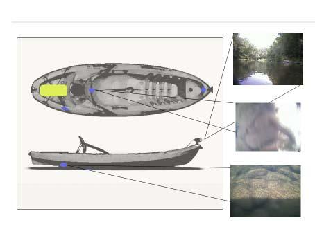
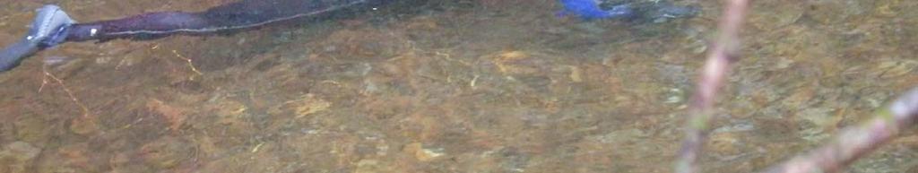
3 WATERPROOF CASE SONAR TRANSDUCER LASERS VIDEO CAMERAS


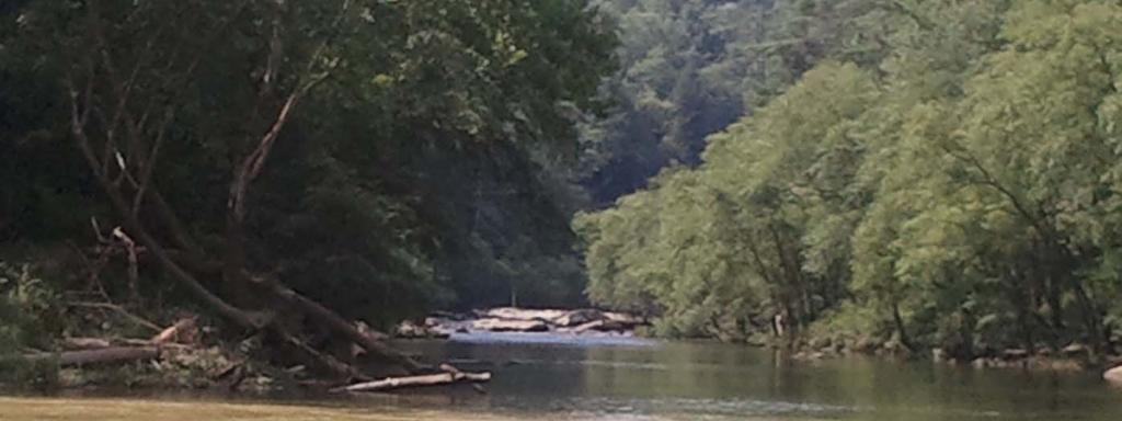
4 Instrumented kayaks floating the river thalweg. GPS and depth sonar Flush mounted underwater camera and lasers Above water camera
5

6 Georeferenced Above Water Image
7 GIS Attributes Defined GPS Position Depth Substrate River Characteristic Embeddedness Substrate Heterogeneity River Width (new) Streambank Vegetation and Cover (new)
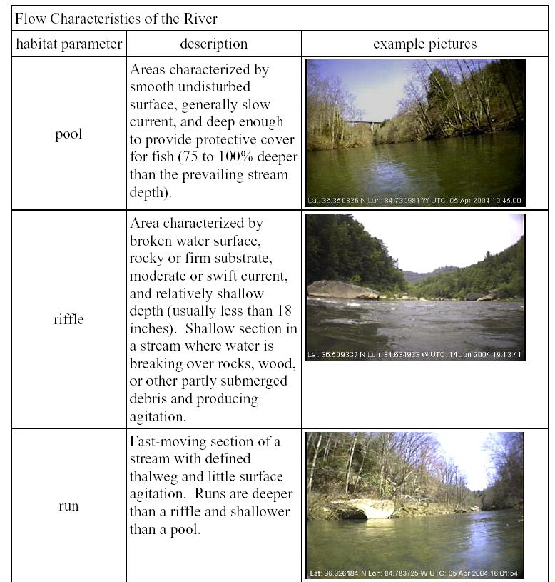
8 EPA river characteristics

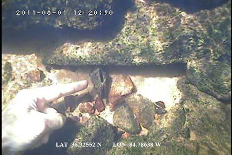
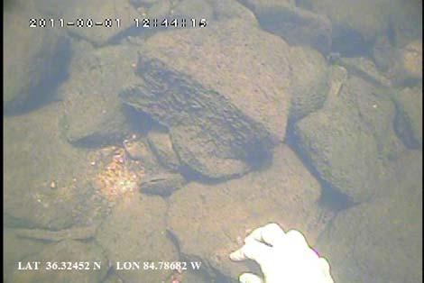
9 Substrate classification viewing
10 Discharge Rate 80 to 95 cfs

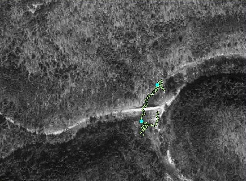
11 GPS Tracklog of the Nottoway River 10.3 miles

12 Depth map of the Nottoway River

13 River Characteristics of Nottoway River

14 GIS Attributes for Optimal Habitat: Depth <= 4 feet Substrate = gravel River Characteristic = riffle or run Roanoke logperch (NANFA, 2016).

15 ArcGIS search criterion for optimal habitat for the Roanoke logperch

16 Optimal Habitat of the Roanoke logperch on the Nottoway River, Fort Pickett (8%)

17 Small section of Optimal Habitat of the Roanoke logperch on the Nottoway River, Fort Pickett

18 GIS Attributes for Optimal Habitat: Depth <= 4 feet Substrate = gravel River Characteristic = riffle Atlantic pigtoe (Laurent, 2016)

19 Optimal Habitat for the Atlantic pigtoe on the Nottoway River, Fort Pickett (2.5%)


20 Driftwood River River Characteristics 20 mile 38,503 Sample Points

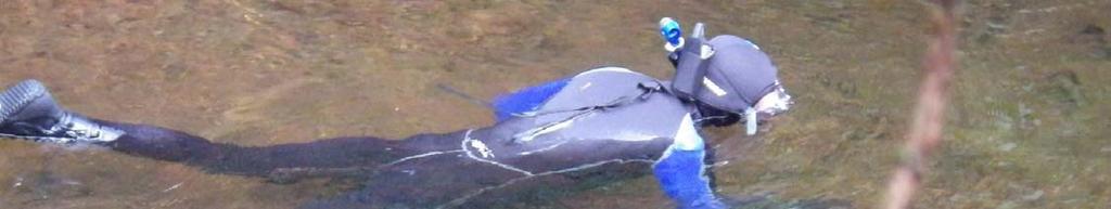
21 Driftwood River Thalweg Depth 20 mile 38,053 Sample Points

22 Driftwood River Substrate 20 mile 38,053 Sample Points


23 Species at Risk Habitat Maps Rayed Bean (Villosa fabalis) mussel Develop Optimum Habitat Criteria
24 Rayed Bean (Villosa fabalis) Habitat Criteria primarily found in small, shallow rivers usually about 4 feet in depth or less in and near riffles/runs usually found deeply buried in sand and gravel substrates often in and around aquatic vegetation Search (Depth <= 4 feet) River Characteristic = riffle/run Substrate = sand or gravel
 6.")
25 Rayed Bean (Villosa fabalis) 6.7% Optimum Habitat

26 US Navy Boca Chica Key Smalltooth Sawfish Habitat

27 Evaluating spatial habitat using parallel GPS tracks and underwater video

28 GPS based Snorkelmapping System for species identification and population monitoring Liquid Image Video Mask and Garmin 64csx GPS Receiver
29 Acquiring Georeferenced Snorkel Video
30


31 SCUBA Mapper under development GPS based SCUBA diver tracking system for georeferencing underwater video for coral reef monitoring
 > 91 =9 0 1ft 1ft 3ft 3ft 6ft 6ft 9ft 9ft 12ft 12ft 18ft >18ft Surface Protect (Avg. %) 100 56 =2.45 55 30 29 15 =4.95 =6.95 < 14 =9 Riparian Diversity Optimal =2.45 Sub Opt =4.")
32 mbehi Score = Rating = Extreme Bank Angle = 6.95, Bank Height = 7.5, Surface Protection = 9, Riparian Diversity = 9 Bank Angle (deg) 0 60 = =4.95 =6.95 Bank Height (ft) > 91 =9 0 1ft 1ft 3ft 3ft 6ft 6ft 9ft 9ft 12ft 12ft 18ft >18ft Surface Protect (Avg. %) = =4.95 =6.95 < 14 =9 Riparian Diversity Optimal =2.45 Sub Opt =4.95 Marginal =6.95 Poor =9 Use EPA BANCS technique to determine streambank erosion rates

 0.00 0.10 0.10 0.35 0.")
33 Fort Benning Upatoi Creek Streambank erosion sediment mapping for TMDL s Upatoi Creek Left Bank Sediment Load (tonnes yr 1 m 1 )
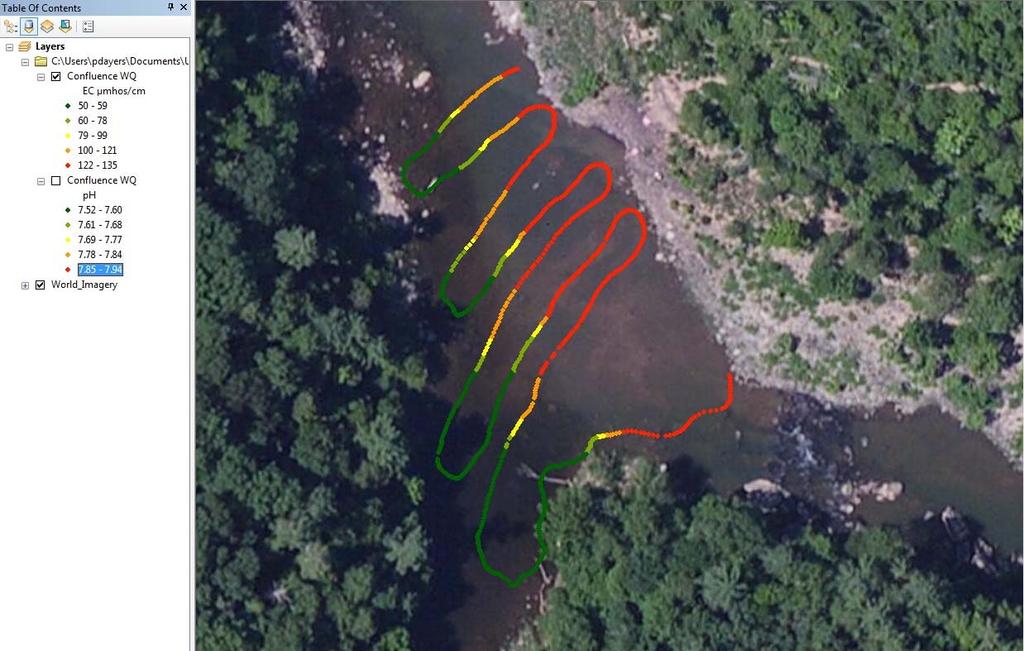
34 Evaluating Geospatial Water Quality

35 Flow cell and data recorder for YSI Sonde

36 Water Quality Mapping (GPS and YSI Sonde)
37 GPS (Trimble or Garmin18) SBAS, 1 3 m accuracy YSI (6920 V2) Temp, ph, EC, DO, Turbidity, TC95<7sec $GPRMC,165541,A, ,N, ,W,001.8,043.8,020617,005.0,W*73 $GPGGA,165541, ,N, ,W,2,09,1.5,250.4,M, 31.9,M,,*7F $YSI,1,17.24,5,177,18,7.53,203,0.6,212,7.26*7B $GPRMC,165542,A, ,N, ,W,001.8,043.3,020617,005.0,W*7B $GPGGA,165542, ,N, ,W,2,08,1.5,250.4,M, 31.9,M,,*7D $YSI,1,17.24,5,177,18,7.53,203,0.5,212,7.26*78 $GPRMC,165543,A, ,N, ,W,001.8,045.0,020617,005.0,W*75 $GPGGA,165543, ,N, ,W,2,09,1.5,250.3,M, 31.9,M,,*70 $YSI,1,17.25,5,176,18,7.53,203,0.4,212,7.26*79 $GPRMC,165544,A, ,N, ,W,001.7,047.1,020617,005.0,W*71 $GPGGA,165544, ,N, ,W,2,08,1.5,250.2,M, 31.9,M,,*78 $YSI,1,17.25,5,176,18,7.53,203,0.3,212,7.26*7E $GPRMC,165545,A, ,N, ,W,001.7,049.3,020617,005.0,W*79 $GPGGA,165545, ,N, ,W,2,09,1.3,250.1,M, 31.9,M,,*78 $YSI,1,17.25,5,176,18,7.53,203,0.4,212,7.25*7A
38
39 Benefits of Kayak based Videomapping Cover large areas (10 miles/day) continuous Non intrusive, no access required Allow for virtual video access in GIS Permanent historical video database, evaluate change The advantage of video mapping every foot of stream is that 1) the total population estimates can be made, and 2) the locations of optimal habitat can be identified and managed Evaluate habitat, streambank erosion, water quality.
40 Transfer plan for mapping aquatic habitat for Species at Risk using the underwater video mapping system Document prepared in final report Site specific based on need Contract or in house or USACE Field data collection (GPS, video, sensor) Use GIS specialist (on site or CEMML) As simple as GPS and GoPro (or smartphone)
41 Questions?
Survey Technique for Underwater Digital Photography with Integrated GPS Location Data
 Survey Technique for Underwater Digital Photography with Integrated GPS Location Data Tim Siwiec: United States Environmental Protection Agency Abstract This survey technique is an inexpensive method of
Vieques Underwater Demonstration Project
 Vieques Underwater Demonstration Project NOAA Office of Response and Restoration National Ocean Service 2006-2007 2007 University of New Hampshire Joint Hydrographic Center 2006 Science Application International
Nearshore Habitat Mapping in Puget Sound Using Side Scan Sonar and Underwater Video
 Nearshore Habitat Mapping in Puget Sound Using Side Scan Sonar and Underwater Video Dana Woodruff, Paul Farley, Amy Borde, John Southard, Ron Thom Battelle Marine Sciences Laboratory Jim Norris Marine
Stream Assessment. Date. Data Collected by. Location. Name of Stream and River Basin. Stream Order. Streambank Materials. Streambank Vegetation
 Stream Assessment Date Data Collected by Location Name of Stream and River Basin Stream Order Streambank Materials Streambank Vegetation Floodplain Soils Floodplain Vegetation Valley Type Valley Constraints
Video-Based Mapping of Oyster Bottom in the Upper Piscataqua River, Sturgeon Creek, and Spruce Creek
 University of New Hampshire University of New Hampshire Scholars' Repository PREP Reports & Publications Institute for the Study of Earth, Oceans, and Space (EOS) 1-21-2009 Video-Based Mapping of Oyster
Eelgrass Survey Reporting Form 2222 Channel Road Newport Beach, CA Eelgrass (Zostera marina) Survey
 Survey") Eelgrass Survey Reporting Form 2222 Channel Road Newport Beach, CA 92660 Eelgrass (Zostera marina) Survey Survey Date: July 19th, 2013 Report Date: July 26 th, 2013 Prepared by: Coastal Resources Management,
Eelgrass Survey Reporting Form 2222 Channel Road Newport Beach, CA 92660 Eelgrass (Zostera marina) Survey Survey Date: July 19th, 2013 Report Date: July 26 th, 2013 Prepared by: Coastal Resources Management,
Understanding the Impacts of Culvert Performance on Stream Health
 Understanding the Impacts of Culvert Performance on Stream Health Kristin Thomas Aquatic Ecologist Michigan Trout Unlimited Transportation and the Environment Conference 12/5/2018 Importance of adequately
Joe Rathbun Michigan DEQ Water Resources Division Nonpoint Source Unit * Thanks to The Nature Conservancy
 Joe Rathbun Michigan DEQ Water Resources Division Nonpoint Source Unit rathbunj@mi.gov * Thanks to The Nature Conservancy Road-stream intersections = 67,511 Culverts = 60,700 Bridges = 6,811 Perched Piping
Chinook Salmon Spawning Study Russian River Fall 2005
 Chinook Salmon Spawning Study Russian River Fall 2005 Sonoma County Water Agency 2150 West College Avenue Santa Rosa, California 95401 Prepared by David Cook - Senior Environmental Specialist March 27,
Creek Trash Assessment (CTA) Methodology (Demonstration: Mill Run Creek, Cheltenham, Pa.)
 Methodology (Demonstration: Mill Run Creek, Cheltenham, Pa.)") Creek Trash Assessment (CTA) Methodology (Demonstration: Mill Run Creek, Cheltenham, Pa.) Mill Run Creek emerges from a storm sewer in Philadelphia to an open creek in Cheltenham. The Creek downstream
Creek Trash Assessment (CTA) Methodology (Demonstration: Mill Run Creek, Cheltenham, Pa.) Mill Run Creek emerges from a storm sewer in Philadelphia to an open creek in Cheltenham. The Creek downstream
New two-lane bridge to replace the existing structure spanning the Maple River just south of the Village s central business district
 New two-lane bridge to replace the existing structure spanning the Maple River just south of the Village s central business district Rehabilitate the old bridge Convert to a nonmotorized trail Restore
WAVE Assessments
 2 2012-2105 WAVE Assessments 3 4 5 6 7 8 Lake George WAVE Stream Monitoring Sites Stream sampling sites in 2015. 9 Stream Name Volunteer DEC Assessment Species Found (Common Name) Habitat Assessment West
Study Update Tailrace Slough Use by Anadromous Salmonids
 Study Update Tailrace Slough Use by Anadromous Salmonids Goals and Objectives Identify what anadromous salmonids use the tailrace slough by: Life Stage (Juvenile, migrating and spawning adults) Timing
DIVE 1: UNDERWATER EXPLORER
 DIVE 1: UNDERWATER EXPLORER Summary This lesson introduces students to the marine habitat and the wealth and diversity of life found in the ocean. Students will learn about how scientists explore underwater,
STREAM SURVEY File form No..
 scanned for KRIS THE RESOURCES AGENCY OF CALIFORNIA California Department of Fish and Game STREAM SURVEY File form No.. Date: September 4, 1969. NAME: North Fork Schooner Gulch Creek COUNTY: Mendocino.
Freshwater Mussel Tagging, Release, and Monitoring Date Prepared: 11/20/2017
 PARTNERSHIP FOR THE DELAWARE ESTUARY Science Group Freshwater Mussel Tagging, Release, and Monitoring Date Prepared: 11/20/2017 Prepared By: Kurt Cheng Suggested Citation: Cheng, K. 2017. Freshwater Mussel
Big Spring Creek Habitat Enhancement and Fishery Management Plans
 Big Spring Creek Habitat Enhancement and Fishery Management Plans November 5, 2012 Big Spring Events and Activities Center Newville, PA Charlie McGarrell Regional Habitat Biologist Pennsylvania Fish and
Restoration of Spawning Habitat for Native Fish in the Central Great Lakes
 Restoration of Spawning Habitat for Native Fish in the Central Great Lakes D. H. B E N N I O N 1, E. R O S E M A N 1, B. M A N N Y 1, G. K E N N E D Y 1, J. B O A S E 2, J C R A I G 1 1 U S G S - G R E
Trout Buffer Variance
 Trout Buffer Variance Ashley L. Rodgers, PE Spring 2015 Why a Trout Buffer Capturing pollutants in runoff to keep the water clean. Capturing sediment to keep mud out of the water. Providing shade to keep
Steelhead Society of BC. Thompson River Watershed Restoration and Enhancement Project #4 Nicola River Bank Stabilization and Enhancement Project
 Steelhead Society of BC Presents: Thompson River Watershed Restoration and Enhancement Project #4 Nicola River Bank Stabilization and Enhancement Project Application for Funding December 2013 1.0 BACKGROUND
NOAA s Underwater UXO Demonstration Projects Vieques Island, Puerto Rico
 NOAA s Underwater UXO Demonstration Projects Vieques Island, Puerto Rico Vieques Restoration Advisory Board Meeting May 7, 2008 Jason Rolfe NOAA s Office of Response & Restoration NOAA s Underwater UXO
2011 SUMMARY REPORT Juvenile Steelhead Densities in the San Lorenzo, Soquel, Aptos and Corralitos Watersheds, Santa Cruz County, CA
 211 SUMMARY REPORT Juvenile Steelhead Densities in the San Lorenzo, Soquel, Aptos and Corralitos Watersheds, Santa Cruz County, CA, Aquatic Biology Don Alley, Jerry Smith and Chad Steiner, Fishery Biologists
EXPEDITION ADVENTURE PART 2: HIGHER RESOLUTION RANGE SEISMIC IMAGING TO LOCATE A SUNKEN PIRATE SHIP OFF ILE ST MARIE.
 EXPEDITION ADVENTURE PART 2: HIGHER RESOLUTION RANGE SEISMIC IMAGING TO LOCATE A SUNKEN PIRATE SHIP OFF ILE ST MARIE. Jakob B.U. Haldorsen, and Douglas E. Miller, Schlumberger-Doll Research, Ridgefield,
PARALENZ RESELLER MANUAL
 PARALENZ RESELLER MANUAL We created this document to familiarize you with the Paralenz Dive Camera and help you sell it. Our 9 USPs What differentiates Paralenz from other action cameras. OUR 9 USPs What
DIRECT INVENTORY TAKING OF UNDERWATER OBJECTS USING A HANDHELD GPS RECEIVER
 DIRECT INVENTORY TAKING OF UNDERWATER OBJECTS USING A HANDHELD GPS RECEIVER ABSTRACT Dariusz Popielarczyk Chair of Satellite Geodesy and Navigation Warmia and Mazury University in Olsztyn The paper presents
Jason Blackburn, Paul Hvenegaard, Dave Jackson, Tyler Johns, Chad Judd, Scott Seward and Juanna Thompson
 Alberta Conservation Association (ACA) Date: 2014-2015 Project Name: Owl River Walleye and Aquatic Habitat Assessment Fisheries Program Manager: Peter Aku Project Leader: Tyler Johns Primary ACA staff
What is Project Baseline?
 What is Project Baseline? A global network of highly skilled and organized SCUBA divers who are creating a lasting visual legacy of underwater conditions in oceans, lakes, rivers, springs, and caves all
March 6, 2013 Tony Giarrusso, Rama Sivakumar Center for GIS, Georgia Institute of Technology
 March 6, 2013 Tony Giarrusso, Rama Sivakumar Center for GIS, Georgia Institute of Technology 33 46 35.74 N, 83 23 48.33 W Location: Georgia Institute of Technology, College of Architecture Established:1996
Preakness Brook - FIBI098
 Preakness Brook - FIBI098 Preakn ess B rook Preakness " ( FIBI098 Naachtpunkt Brook 202 80 IBI Ratings FIBI Sampling Location Excellent Small Streams (1st and 2nd Order) Good Fair Large Streams (3rd Order
Using Habitat Guilds to Develop Habitat Suitability Criteria for a Warmwater Stream Fish Assemblage. Jason Persinger, Don Orth,, Tammy Newcomb
 Using Habitat Guilds to Develop Habitat Suitability Criteria for a Warmwater Stream Fish Assemblage Jason Persinger, Don Orth,, Tammy Newcomb Shenandoah River Basin North Fork Shenandoah River 20% discharge
SUMMARY OF MOVEMENT AND HABITAT USED BY TAGGED BROOK TROUT IN THE MAIN BRANCH AND NORTH BRANCH AU SABLE RIVER DURING SUMMER Data Submitted to:
 SUMMARY OF MOVEMENT AND HABITAT USED BY TAGGED BROOK TROUT IN THE MAIN BRANCH AND NORTH BRANCH AU SABLE RIVER DURING SUMMER 2014 Data Submitted to: Anglers of the Au Sable Submitted by: Dr. Mark R. Luttenton
Oyster Bed Mapping in the Great Bay Estuary,
 University of New Hampshire University of New Hampshire Scholars' Repository PREP Reports & Publications Institute for the Study of Earth, Oceans, and Space (EOS) 6-26-2013 Oyster Bed Mapping in the Great
Mussel Monitoring in Eau Claire County. Anna Mares Citizen Science Center April 10, 2013
 Mussel Monitoring in Eau Claire County Anna Mares Citizen Science Center April 10, 2013 Mussels/clams/fresh water bivalves What are the defining features of this group of animals? Clam comes from Old High
Minnesota Department of Natural Resources Division of Fish and Wildlife Section of Fisheries. Stream Survey Report. Luxemburg Creek.
 Minnesota F-29-R(P)-24 Area 315 Study 3 March 2016 Minnesota Department of Natural Resources Division of Fish and Wildlife Section of Fisheries Stream Survey Report Luxemburg Creek 2015 Mark Pelham Sauk
LAKE JESUP VEGETATION MAPPING: AN INTER-AGENCY COLLABORATION. Lakshmi Sankaran, GISP Public Works Department, Seminole County
 LAKE JESUP VEGETATION MAPPING: AN INTER-AGENCY COLLABORATION Lakshmi Sankaran, GISP Public Works Department, Seminole County LAKE JESUP Area - 12 sq miles Shoreline - 53 miles Watershed - 136 sq miles
Nechako white sturgeon are an Endangered Species
 Nechako white sturgeon are an Endangered Species There are likely less than 350 Nechako white sturgeon, and historically there were over 5000 in the Nechako Watershed. Endangered as per the Species at
STUDY PERFORMANCE REPORT
 STUDY PERFORMANCE REPORT State: Michigan Project No.: F-80-R-4 Study No.: 702 Title: Effects of sediment traps on Michigan river channels Period Covered: October 1, 2002 to September 30, 2003 Study Objectives:
Distribution. PFBC Northcentral Region Law Enforcement Office, Attention: WCO Kraynak, 1150 Spring Creek Road, Bellefonte, PA 16823
 Distribution Pennsylvania Department of Environmental Protection, Northcentral Region Office, Attention: Steve Means, 208 West Third St. Suite 101, Williamsport, PA 17701 PFBC Northcentral Region Law Enforcement
Fish Habitat Restoration and Monitoring in Southeast Washington. Andy Hill Eco Logical Research, Inc.
 Fish Habitat Restoration and Monitoring in Southeast Washington Andy Hill Eco Logical Research, Inc. Fish Habitat Restoration and Monitoring in Southeast Washington Talk overview: Restoration projects
Eelgrass and Macroalgae Presence/Absence Preliminary Surveys BHP Proposed Grays Harbor Potash Export Facility A Task 400
 Memorandum 40600-HS-MEM-55036 Revision 0 Date: 26 July 2018 Subject: Eelgrass and Macroalgae Presence/Absence Preliminary Surveys BHP Proposed Grays Harbor Potash Export Facility A17.0202.00 Task 400 INTRODUCTION
PROJECT TO INSTALL LARGE WOOD HABITAT STRUCTURES IN THE CARMEL RIVER USING CALIFORNIA DEPARTMENT OF FISH AND GAME GRANT FUNDS
 PROJECT TO INSTALL LARGE WOOD HABITAT STRUCTURES IN THE CARMEL RIVER USING CALIFORNIA DEPARTMENT OF FISH AND GAME GRANT FUNDS The Monterey Peninsula Water Management District (MPWMD), in cooperation with
Vieques Munitions Response: Current Issues
 Vieques Munitions Response: Current Issues NAOC General Membership Meeting December 7, 2016 Agenda Project Overview Surface Clearance Subsurface Clearance Remote Controlled Equipment Underwater MEC Open
Culvert Design for Low and High Gradient Streams in the Midwest. Dale Higgins, Hydrologist Chequamegon-Nicolet National Forest
 Culvert Design for Low and High Gradient Streams in the Midwest Dale Higgins, Hydrologist Chequamegon-Nicolet National Forest Overview Culvert Design Considerations Hydraulic Terms Culvert Impacts Low
Minnesota Department of Natural Resources Division of Fish and Wildlife Section of Fisheries. Stream Survey Report. Three Mile Creek 2011
 Minnesota Department of Natural Resources Division of Fish and Wildlife Section of Fisheries Stream Survey Report Three Mile Creek 2011 By Joseph D. Stewig Montrose Area Fisheries Office TABLE OF CONTENTS
Don Pedro Project Relicensing
 Don Pedro Project Relicensing M ODESTO I RRIGATION D ISTRICT TURLOCK I RRIGATION D ISTRICT FERC PROJECT N O. 2299 Resident Fish in Don Pedro Reservoir Don Pedro Reservoir Fish Stocking (1971-Present) CDFG
Small Footprint Topo-Bathymetric LiDAR
 May 8, 2013 Small Footprint Topo-Bathymetric LiDAR PNAMP Remote Sensing Forum Russ Faux, Co-CEO, WSI Amar Nayegandhi, Manager of Elevation Technologies, Dewberry Colin Cooper, Senior Analyst, WSI Watershed
Hydraulic Modeling of Stream Enhancement Methods
 Hydraulic Modeling of Stream Enhancement Methods Matthew J. Curry John J. Levitsky Abstract Development within watersheds increases the amounts of runoff causing stream erosion and degradation of stream
Volunteer and Internships Programs ECUADOR
 Volunteer and Internships Programs ECUADOR Equilibrio Azul is a non-for profit organization created in 2005 to protect the marine resources of Ecuador. Our mission is to integrate local communities, governmental
Investigation of Submarine Springs and other Karst Features in Coastal Regions of the SWFWMD
 Investigation of Submarine Springs and other Karst Features in Coastal Regions of the SWFWMD by David J. DeWitt, P.G. Southwest Florida Water Management District January 2004 FDEP Q- Meeting Clearwater
Data Report : Russian River Basin Steelhead and Coho Salmon Monitoring Program Pilot Study
 Data Report 1999-1: Russian River Basin Steelhead and Coho Salmon Monitoring Program Pilot Study Sonoma County Water Agency 215 West College Avenue Santa Rosa, California 951 Prepared by David Cook Senior
METHODS PAPER: Downstream Bathymetry and BioBase Analyses of Substrate and Macrophytes
 Mactaquac Aquatic Ecosystem Study Report Series 2015-006 METHODS PAPER: Downstream Bathymetry and BioBase Analyses of Substrate and Macrophytes Ben Wallace, Jae Ogilvie and Wendy Monk 17 February 2015
NEED FOR SUPPLEMENTAL BATHYMETRIC SURVEY DATA COLLECTION
 305 West Grand Avenue, Suite 300 Montvale, New Jersey 07645 Phone 201.930.9890 Fax 201.930.9805 www.anchorqea.com M EMORANDUM To: Caroline Kwan and Nica Klaber U.S. Environmental Protection Agency Region
APPLICANT: Pacific Northwest National Laboratory Attention: Mr. Charles Brandt 1529 West Sequim Bay Road Sequim, Washington 98382
 US Army Corps of Engineers Seattle District Joint Public Notice Application for a Department of the Army Permit and a Washington Department of Ecology Water Quality Certification and/or Coastal Zone Management
LONGITUDINAL FIELD METHODOLOGY FOR THE ASSESSMENT OF TMDL SEDIMENT AND HABITAT IMPAIRMENTS
 LONGITUDINAL FIELD METHODOLOGY FOR THE ASSESSMENT OF TMDL SEDIMENT AND HABITAT IMPAIRMENTS Montana Department of Environmental Quality 1520 East Sixth Avenue Helena, Montana 59620 June 2007 TABLE OF CONTENTS
Blue River Restoration Project William D. Linfield, P.E.
 Blue River Restoration Project William D. Linfield, P.E. 1 2 3 4 5 Blue River Restoration Project BUILDING BRIDGES BETWEEN COMMUNITIES IN COOPERATION WITH THE NATIONAL FOREST FOUNDATION Building Bridges
F I B I ST 519 OP 57. [ Excellent [ Fair. [ Poor. U p p e r D e l a w a r e W M A 1. C e n t r a l D e l a w a r e W M A 1 1.
 L o p a t c o n g C r e e k F I B I 0 0 4 # Allens Mills Uniontown # ST 519 U p p e r D e l a w a r e W M A 1 Lopatcong Creek 22 OP 57 [ 78 Still Valley # C e n t r a l D e l a w a r e W M A 1 1 FIBI Rating
Certified Professionals in Hydrographic Solutions
 Certified Professionals in Hydrographic Solutions Client Satisfaction is our Deliverable Port of Brisbane Pty Ltd Port Surveys Certified Professionals in Hydrographic Surveying Tel +61 (0) 7 3258 4820
Eastern Brook Trout Joint Venture. Update
 Eastern Brook Trout Joint Venture (EBTJV) Update Mark Hudy USDA Forest Service, Fish and Aquatic Ecology Unit NFHAB Board Meeting April 17, 2012 Introduction Assessment Case History 1. Evaluate the distribution
Boost Your Skills with On-Site Courses Tailored to Your Needs
 Boost Your Skills with On-Site Courses Tailored to Your Needs www.aticourses.com The Applied Technology Institute specializes in training programs for technical professionals. Our courses keep you current
Consigned to the deep: requiem or recovery of VR2W receivers in a freshwater river gorge after a 1:2-3 3 year ARI flood
 Consigned to the deep: requiem or recovery of VR2W receivers in a freshwater river gorge after a 1:2-3 3 year ARI flood 1 Ivars Reinfelds, 2,3 Chris Walsh and 1 Tim Haeusler 1 Department of Water and Energy,
1.Mill Creek Watershed Summary Description and Land Use
 1.Mill Creek Watershed Summary Description and Land Use Table xxx: Mill Creek Watershed Overview Watershed Size 31,435 acres/49.1 sq miles/ 127.1 sq km Elevation Range 5,594 feet [4,967-10,561] Stream
DRAFT TECHNICAL MEMORANDUM
 DRAFT TECHNICAL MEMORANDUM From: File No.: 213.001 Re: Beaux Arts Village Shoreline - 2016 Introduction The Washington Academy of Beaux Arts (WABA) completed shoreline habitat restoration at three locations
2012 SOUTH RIVER FISH COMMUNITIES AND PHYSICAL HABITAT ASSESSMENT, FRANKLIN COUNTY, MASSACHUSETTS
 2012 SOUTH RIVER FISH COMMUNITIES AND PHYSICAL HABITAT ASSESSMENT, FRANKLIN COUNTY, MASSACHUSETTS Prepared by Michael B. Cole, Ph.D. ABR, Inc. Environmental Research & Services Greenfield, MA For Deerfield
High Definition Laser Scanning (HDS) Underwater Acoustic Imaging and Profiling
 Underwater Acoustic Imaging and Profiling") High Definition Laser Scanning (HDS) Underwater Acoustic Imaging and Profiling Images at Depth: The Use of Acoustic Imaging on Large River Crossings A Case Study AGENDA Background of project Review of
High Definition Laser Scanning (HDS) Underwater Acoustic Imaging and Profiling Images at Depth: The Use of Acoustic Imaging on Large River Crossings A Case Study AGENDA Background of project Review of
Pequannock River - FIBI077
 Pequannock River - FIBI077 Canistear Rsvr. Clint on Brook Clinton R svr. k R r. idge Rs v Echo Lake Oa 23 Pequann ock R iver FIBI077 Kinnelon 287 23 FIBI Sampling Location Small Streams (1st and 2nd Order)
Challenges in determining water surface in airborne LiDAR topobathymetry. Amar Nayegandhi, Dewberry 15 th Annual JALBTCX Workshop, June 11 th 2014
 Challenges in determining water surface in airborne LiDAR topobathymetry Amar Nayegandhi, Dewberry 15 th Annual JALBTCX Workshop, June 11 th 2014 Why topobathy LiDAR? Complements acoustic (multi-beam sonar)
Great Lakes Stream Crossing Inventory Instructions
 Great Lakes Stream Crossing Inventory Instructions This document is a guide to completing the Stream Crossing Data Sheet (2/28/11 version). Careful attention to this guidance will ensure consistent crossing
Fish monitoring requirements of new FERC licenses: are they adequate?
 Fish monitoring requirements of new FERC licenses: are they adequate? Joseph D. Kiernan, Peter B. Moyle and John G. Williams Center for Watershed Sciences University of California, Davis Trends from recently
Fraser River. FISH SURVEY AND MANAGEMENT INFORMATION Jon Ewert - Aquatic Biologist (Hot Sulphur Springs)
") Fraser River FISH SURVEY AND MANAGEMENT INFORMATION Jon Ewert - Aquatic Biologist (Hot Sulphur Springs) General Information: The Fraser River is a highly diverse river offering many transitions in habitat
Fraser River FISH SURVEY AND MANAGEMENT INFORMATION Jon Ewert - Aquatic Biologist (Hot Sulphur Springs) General Information: The Fraser River is a highly diverse river offering many transitions in habitat
Beaver Brook - FIBI047 Hope
 Beaver Brook - FIBI047.-,80 Silve r Lake Mud dy Br ook % Hope Honey Run Beaver Brook FIBI047 #S #S FIBI Sampling Location Small Streams (1st and 2nd Order) Large Streams (3rd Order and Above) N 0 1 2 3
1.Warm Springs Creek (Anaconda) Watershed Description and Land Use
 Watershed Description and Land Use") 1.Warm Springs (Anaconda) Watershed Description and Land Use Table xxx: Warm Springs Watershed Overview Watershed Size 92,288 acres/144.2 sq miles/373.6 sq km Elevation Range 5,781 feet [4,800-10,581]
1.Warm Springs (Anaconda) Watershed Description and Land Use Table xxx: Warm Springs Watershed Overview Watershed Size 92,288 acres/144.2 sq miles/373.6 sq km Elevation Range 5,781 feet [4,800-10,581]
Juvenile Steelhead and Stream Habitat Conditions Steelhead and Coho Salmon Life History Prepared by: DW ALLEY & Associates, Fishery Consultant
 Juvenile Steelhead and Stream Habitat Conditions Steelhead and Coho Salmon Life History Prepared by: DW ALLEY & Associates, Fishery Consultant I-1. Steelhead and Coho Salmon Ecology Migration. Adult steelhead
Niangua Darter Monitoring Report 2010
 Niangua Darter Monitoring Report 2010 Longest Niangua Darter on record (total length 132 mm/5.2 in); Little Pomme de Terre River Doug Novinger and Jamey Decoske Missouri Department of Conservation Resource
U.S. Fish and Wildlife Service Stream Habitat Improvement Projects
 U.S. Fish and Wildlife Service Stream Habitat Improvement Projects Melanie Car ter and Corey Kanuckel U.S. Fish & Wildlife Service Partners for Fish & Wildlife (PFW) Stream Team: Drew Langston Hunter Kittrell
Robin J. Beaman. School of Earth and Environmental Sciences, James Cook University, Cairns, Qld 4870, Australia.
 Robin J. Beaman School of Earth and Environmental Sciences, James Cook University, Cairns, Qld 4870, Australia. Email: robin.beaman@jcu.edu.au Seminar to SSSI Qld Hydrography Coping with Nature, Brisbane,
MINNESOTA DEPARTMENT OF NATURAL RESOURCES DIVISION OF FISHERIES AND WILDLIFE. Gamefish Assessment Report
 Minnesota DNR F-29-R(P) Area F312 February 1, 2013 MINNESOTA DEPARTMENT OF NATURAL RESOURCES DIVISION OF FISHERIES AND WILDLIFE Gamefish Assessment Report Spring Gamefish Assessment on the Mississippi
ATTACHMENT F. Minnesota Department of Natural Resources. Marsh Lake Ecosystem Restoration Project
 ATTACHMENT F Minnesota Department of Natural Resources Marsh Lake Ecosystem Restoration Project Mussel Rescue and Translocation Plan for Pomme de Terre River Restoration (Prepared June, 2016) Attachment
Illinois Lake Management Association Conference March 23, 2018 By Trent Thomas Illinois Department of Natural Resources Division of Fisheries
 Illinois Lake Management Association Conference March 23, 2018 By Trent Thomas Illinois Department of Natural Resources Division of Fisheries Sources of Habitat Impairment Sedimentation Channelization
Ausable River Aquatic Habitat Assessment
 Ausable River Aquatic Habitat Assessment ~ 2005 ~ Prepared by: Kari Killins, Mari Veliz & Shawn Staton (DFO) Ausable Bayfield Conservation Authority Prepared for: Ausable River Recovery Team Fisheries
APPLICATION OF SOUND PROPAGATION (IN THE PERSIAN GULF AND OMAN SEA)
") APPLICATION OF SOUND PROPAGATION (IN THE PERSIAN GULF AND OMAN SEA) Seyed Majid Mosaddad Department of Physics, Shoushtar Branch, Islamic Azad University, Shoushtar, Iran Email: mosaddad5@gmail.com Abstract
APPLICATION OF SOUND PROPAGATION (IN THE PERSIAN GULF AND OMAN SEA) Seyed Majid Mosaddad Department of Physics, Shoushtar Branch, Islamic Azad University, Shoushtar, Iran Email: mosaddad5@gmail.com Abstract
Proposed Reclassification of Horse Creek, North Platte River Basin in Goshen County, Wyoming
 Proposed Reclassification of Horse Creek, North Platte River Basin in Goshen County, Wyoming October 25, 2010 Waterbody: Location: Tributary to: Horse Creek - Mainstem from the confluence with Stinking
Utilizing Vessel Based Mobile LiDAR & Bathymetry Survey Techniques for Survey of Four Southern California Breakwaters
 Utilizing Vessel Based Mobile LiDAR & Bathymetry Survey Techniques for Survey of Four Southern California Breakwaters Western Dredging Association: Pacific Chapter September 2012 Insert: Pipe Location
WALTON COUNTY NRDA ARTIFICIAL REEF PROGRAM
 WALTON COUNTY NRDA ARTIFICIAL REEF PROGRAM Melinda Gates Lauren Floyd Kathryn Brown Beau Suthard, PG Franky Stankiewicz Walton County - Coastal Resource Liaison APTIM - Senior Marine Biologist APTIM -
~ A Behavioral Response Study in 2007 &2008 (BRS 07/08) was conducted in the Bahamas to
 was conducted in the Bahamas to") Biological and Behavioral Response Studies in the Bahamas in 27 28 (BRS 7/8) ~ Project Summary ~ ~ A Behavioral Response Study in 27 &28 (BRS 7/8) was conducted in the Bahamas to study diving behavior
Biological and Behavioral Response Studies in the Bahamas in 27 28 (BRS 7/8) ~ Project Summary ~ ~ A Behavioral Response Study in 27 &28 (BRS 7/8) was conducted in the Bahamas to study diving behavior
Identifying and Executing Stream Projects Kristin Thomas, Aquatic Ecologist MITU
 Identifying and Executing Stream Projects Kristin Thomas, Aquatic Ecologist MITU Introduction 1. Methods for Identifying Projects 2. Methods in Action 3. The Partnership Paradigm 2 River Stewards Program
Trout Habitat Improvements On Hay Creek
 Trout Habitat Improvements On Hay Creek Jason Peterson "When we try to pick out anything by itself, we find it is hitched to everything else in the universe." - John Muir - Instream habitat for trout in
SECTION F FISH HABITAT CONDITION AND AQUATIC SPECIES DISTRIBUTION
 SECTION F FISH HABITAT CONDITION AND AQUATIC SPECIES DISTRIBUTION INTRODUCTION The fish species currently inhabiting the Gualala River WAU are steelhead trout (Oncorhynchus mykiss), sculpin (Cottus spp.),
Environmental. Effects of Dredging
 Envi~onmental Effects of Dredging Technical Notes THE VALUE OF GRAVEL DISPOSAL MOUNDS IN RIVER SIDE CHANNELS FOR FRESHWATER MUSSELS PURPOSE: This note provides information on the value of gravel disposal
An Overview of Methods for Estimating Absolute Abundance of Red Snapper in the Gulf of Mexico
 An Overview of Methods for Estimating Absolute Abundance of Red Snapper in the Gulf of Mexico JM Drymon 1, Greg Stunz 2 1. Mississippi State University, Coastal Research and Extension Center 2. Harte Research
Little Manistee River Instream Fish Habitat Assessment
 Little Manistee River Instream Fish Habitat Assessment Michigan Trout Unlimited February 215 Kristin Thomas Dr. Bryan Burroughs 1 Table of Contents PURPOSE & CONTEXT... 3 INTRODUCTION... 4 Table 1. Michigan
Blue River Restoration Project
 Blue River Restoration Project Blue River Restoration Project BUI LDI NG BRI DGES BETWEEN COMMUNI TI ES I N COOPERATI ON WI TH THE NATI ONAL FOREST FOUNDATI ON The Blue River Restoration project is an
Climate change and the California golden trout
 Climate change and the California golden trout Kathleen R. Matthews US Forest Service Research Sierra Nevada Research Center Outline Golden trout background How climate change may impact CGT and their
 D.W. ALLEY & Associates Aquatic Biology -------------------------------------------------------------------------- 2006 Juvenile Steelhead Densities in the San Lorenzo, Soquel, Aptos and Corralitos Watersheds,
Fish Community. Fish Habitat, Streams and Rivers
 Clear, Ston(e)y and White Lake Plan Fish Community The lakes support a cool/warm water fishery including muskellunge, walleye, largemouth and smallmouth bass, yellow perch, pumpkinseed, rockbass, blue
Cross-Country Madness: Run for Your Life
 Cross-Country Madness: Run for Your Life BY: THE MAPSTERBATORS- JHON AFRIDI, EMMA LUNDBERG, LUCAS REYES 12TH OF DECEMBER, 2014 Abstract Athletic facilities at Redwood Fields in Eureka, CA are assessed
South Fork Chehalis Watershed Culvert Assessment
 South Fork Chehalis Watershed Culvert Assessment Water Resource Inventory Area 23 Lewis County Conservation District Final Report By: Kelly Verd and Nikki Wilson March 2003 Funded by: The Washington State
Study Update Fish Distribution and Species Composition
 Study Update Fish Distribution and Species Composition Goals and Study Area Gain a better understanding of fish species composition and abundance in waters associated with the Packwood Lake Hydroelectric
SUMMARY OF RESULTS FIBI054
 SUMMARY OF RESULTS FIBI054 1. Stream Name: Lamington River 2. Sampling Date: 7/10/2007 3. Sampling Location: McCann Mill Road 4. Municipality Tewksbury Township 5. County: Hunterdon 6. Watershed Management
2014 Threatened and Endangered Fish Survey of. East Loon Lake and West Loon Lake. Lake County, Illinois
 2014 Threatened and Endangered Fish Survey of East Loon Lake and West Loon Lake Lake County, Illinois Prepared by Integrated Lakes Management 120 LeBaron St. Waukegan, IL 60085. Chris Ryan Chris Rysso
STREAM Girls field notebook
 s STREAM Girls field notebook Welcome...... to your stream! Trout Unlimited is excited to offer you and other Girl Scouts the chance to really get to know your home waters. Over the next three days, you