Community Beach Seining at Ship Harbor, Fidalgo Island, Washington, August 2012
|
|
|
- Amber Stone
- 5 years ago
- Views:
Transcription


1 Community Beach Seining at Ship Harbor, Fidalgo Island, Washington, August 2012 By Paul Dinnel and Jude Apple Shannon Point Marine Center, Western Washington University December 2012
2 Acknowledgments The Skagit County Marine Resources Committee and Shannon Point Marine Center thanks the following for their valuable assistance with the Community Beach Seining Project: Report Authors: Paul Dinnel and Jude Apple, Shannon Point Marine Center Project Funding: Burning Foundation, Northwest Straits Foundation and Shannon Point Marine Center, Western Washington University Project Management: Joan Drinkwin and Tracie Johannessen, Northwest Straits Foundation and Paul Dinnel, Skagit Marine Resources Committee Vessel Operators: Nathan Schwarck and Jay Dimond, Shannon Point Marine Center WSU Beach Watcher, Skagit MRC, Shannon Point Marine Center and Community Volunteers: Dan McCroskey, Erica Pickett, Pat Steffani, Austin Rose, Charles O Hara, Kathleen McDanold, Bruce McDanold, Lin Folsom, Dixon Elder, Mike Mohundro, Patti Hutchins, Chris Brown, Kurt Buchanan, Nancy Olsen, Morty Cohen, Lennon Beckman, Thomson, Anne Benolkin, Pete Hasse, Christna Goethel, Sarah DeLand, Venna Dohman, Alannah Pratt, John Helmerl, Sylvia Yang, Klara Schwarz, Suann Yang, Carrie Schwarz, Christian Schwarz, Cory Tolman, Judy Boum, Bob Weathers, Lynn Coffelt, Elyse Etlicher, Maggie Irving, Mira Lutz, Tracy Alker, Daron Jones, Jacob Jones, Joel Jones, Clareesa Jones, Rachel Jones, Merci Jones, John Patton, Gabe Velazquel, Cadel Velazquel, Maya Velazquel, Andrea Doll, Lauren Falkenberg, Melanie Tate, Steve Hanson. Partner Organizations: Skagit Marine Resources Committee, Shannon Point Marine Center, Skagit County WSU Beach Watchers, City of Anacortes, Port of Anacortes, Northwest Straits Foundation and the Burning Foundation. 2
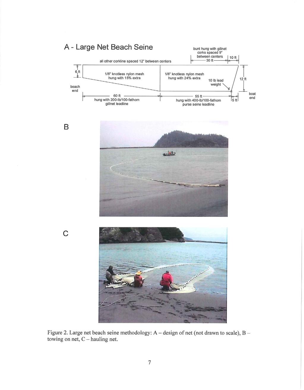
3 Community Beach Seining at Ship Harbor, Fidalgo Island, Washington, August 2012 Introduction One of the goals of the Northwest Straits Commission is to facilitate citizen science by training local citizens on how to collect scientific data and monitor the status of our marine resources and habitats. A second goal of the Commission is to provide education and outreach activities for local communities. The purpose of the Community Beach Seining project is to address both of these goals by using community volunteers to collect fish monitoring data and interact with interested community citizens by including them in the sampling efforts and data collection. Beach seining at Ship Harbor is continuing, in part, the fish sampling initiated at this location in 2010 as part of Skagit County Marine Resources Committee s (Skagit MRC) Cannery Pond Evaluation Project, which was primarily conducted by a WWU graduate student (Dinnel and Seyl 2011). Continuation of fish sampling in 2011, 2012 and beyond will provide a longer term fish database for this North Fidalgo Island (west Guemes Channel) location, which is not being monitored for fish by any other organization. All data collected will be forwarded to Skagit River Systems Cooperative, which maintains an extensive database for seine sampling in Skagit County waters, especially in relation to juvenile salmonid species. This report summarizes the Community Beach Seine sampling conducted at Ship Harbor on August 13, Data from this effort are presented in this report, and also includes comparisons to two previous sampling efforts at Ship Harbor (August 2011 and June 2012). Additional information and data from these two previous sampling efforts may be found in an earlier report (Dinnel and Apple 2012). Methods The location of the beach seining site is Ship Harbor, which is located on the northwest side of Fidalgo Island just east of the Washington State San Juan Island Ferry Terminal (Fig. 1). The tidelands are owned by the Port of Anacortes and the uplands are owned by the City of Anacortes, both which have given their permission for site access All seining activities were conducted at high tides (+6.0 foot or higher). The site substrate is sand with a cobble fringe at the high tide level. The dominant vegetation is algae, with sea lettuce (Ulva spp.) being the dominant vegetation. Two previous Community Beach Seine sampling and education events were held on 8 August 2011 and 14 June The sampling reported in this report occurred on 13 August Sampling was conducted with a large net beach seine measuring 120 (36.6 m) long by 12 (3.7 m) deep by 1/8 (0.3 cm) mesh knotless nylon net using sampling protocols established by the Skagit River System Cooperative Research Department (SRSC 3
4 2003) (Appendix 2). The beach seine was set using Shannon Point Marine Center s research vessel Fauna (Fig. 2). All volunteers were given an introduction and brief training session prior to sampling (Fig. 3). The net was set three successive times for four minutes each before being pulled to the beach by volunteers (Fig. 4). Once the net was retrieved, volunteers then captured all fish in the net and identified each fish to species or genus and measured each fish for total length (or counted excess fish when there were more than 25 of a given species -- Fig. 5), using the following fish guides: Hart 1973, Kramer et al. 1995, The Mountaineers 1984, Steele 2011, and a locally produced laminated fish guide based on illustrations posted on the Oregon Department of Fish and Wildlife s website ( All fish were handled carefully, maintained in large buckets of seawater until measured and released alive at the sampling site. Results Fish Catches The three August 2012 beach seine samples contained 530, 1,763 and 1,121 fish for a total of 3,414 fish for all three samples (Table 1). Thirteen species (or groups of species) were represented in the samples including: Juvenile Chinook salmon, Oncorhynchus tshawytscha Starry flounder, Platichtys stellatus English sole, Parophrys vetulus Speckled sanddab, Citharichthys stigmaeus Pacific shiner perch, Cymatogaster aggregata Staghorn sculpin, Leptocottus armatus Surf smelt, Hypomesus pretiosis Pacific sand lance, Ammodytes hexapterus Greenling sp. (Hexagrammos sp.) Pacific tomcod, Microgadus proximus Snake prickleback, Lumpenus sagitta Threespine stickleback, Gasterosteus aculeatus Gunnel sp., Family Pholidae All of these species are common to Puget Sound. Of particular note were the high catches of surf smelt, juvenile English sole, Pacific shiner perch and snake prickleback (Table 1). Size frequency histograms were prepared for some of the most commonly caught species (Figs. 6-13) and include comparisons of fish size distributions for this sampling and the two previous sample efforts in August 2011 and June These histograms show that all of the Chinook and pink salmon were caught in 2012 and were juveniles in transit from their natal rivers to the ocean (Figs. 6 and 7). Surf smelt, only caught in 2012, were mostly juveniles ( mm) (Fig 8). English sole and starry flounder were caught in both years and were mostly juveniles, the sizes indicating that these fish likely represented several year classes (Figs. 9 and 10). Pacific shiner perch were caught in both years and were mostly adults, with a few juveniles, especially in August 2012 (Fig. 11). This species produces live during the summer, which measure approximately mm in length. Snake prickleback were caught in both years and were mostly adults measuring between
5 mm (Fig. 12). Staghorn sculpin were very common in the catches of both years and included a wide range of sizes from juveniles to adults (Fig. 13). Summaries of the individual fish sizes (or subset of fish when many of a given species were caught) appear in Appendix Table 1. Community Beach Seine Partners and Participants This project was coordinated by Skagit MRC (project coordination/administration, data management, report preparation and the beach seine) in cooperation with Shannon Point Marine Center (boat and skipper, three Marine Scientists and students), the City and Port of Anacortes (site access) and WSU Beach Watchers (assist with setting the seine, measuring and identifying the fish, recording the data and interacting with the public invited to the events). Volunteers for these two seining events included: Nine Shannon Point Marine Center participants, including three Marine Scientists (Drs. Paul Dinnel, Jude Apple and Sylvia Yang), SPMC staff (Nate Schwarck and Jay Dimond) and four graduate and undergraduate students Four members of the Skagit Marine Resources Committee At least 17 trained Washington State University Beach Watchers In addition, approximately interested citizens and kids from the community (including persons walking the beach while waiting in the ferry line) participated in the event. Volunteer Hours Total volunteer time expended for the two Community Beach Seining events, including the sampling efforts, project coordination/administration and final report preparation was approximately 160 hours. This does not include the efforts by the citizens from the community who assisted with (or observed) the sampling. Cost Matching Most of the cost for this project was for the research vessel used to set the beach seine and the skipper s time. The hourly cost for the vessel and skipper was $110/hour. Four hours of vessel/skipper time were used for the August 2012 Community Beach Seine event. The Northwest Straits Foundation and Burning Foundation provided half of the funding ($550) for this sampling event. Dr. Steve Sulkin, Director of the Shannon Point Marine Center, contributed the other half of the vessel charter fees as a co-partner for this effort. Event Advertising Advertising for this event appeared in several editions of the local Anacortes American weekly newspaper in the Community Events section and one edition of the Skagit Valley Herald. Following is an example press release prepared for the event and sent to the local newspapers for publication: 5
6 Press Release Invitation to Community Beach Seine Sampling Skagit County Marine Resources Committee (Skagit MRC) and Shannon Point Marine Center are co-sponsoring a Community Beach Seine sampling event at Ship Harbor, next to the San Juan Ferry Terminal in Anacortes on Monday, August 13 th. Students, community members and any interested persons are invited to assist and learn about local marine life. Skagit County Beach Watchers, Skagit MRC members and students and staff of Shannon Point Marine Center will be on hand to lead the sampling effort and identify and measure fish caught in the net. Sampling will take place from 3:00 to 5:00 PM. To find out more information or to volunteer for this event, call Paul Dinnel at (mornings) or (afternoons, evenings, weekends) or padinnel@aol.com. Future Community Beach Seining Events Community Beach Seining events may be held in 2013 and future years but will depend on the availability of continued funding from some source. The original source, the Northwest Straits Commission, no longer has funds to support Marine Resources Committee projects due to the deletion of earmark funds by Congress. The most recent sampling effort (August 2012) was supported by private funding (Burning Foundation). 6
7 References Dinnel, P. and H. Seyl Investigation into the historic status of Cannery Pond, and its potential for restoration as a future pocket estuary. Final Report by Shannon Point Marine Center, Western Washington University for the Skagit County Marine Resources Committee and the Northwest Straits Commission, Mt. Vernon, WA. 51 pp. Dinnel, P. and J. Apple Community beach seining at Ship Harbor, Fidalgo Island, Washington, 2011 and Final Report by Shannon Point Marine Center, Western Washington University for the Skagit County Marine Resources Committee and the Northwest Straits Commission, Mt. Vernon, WA. 33 pp. Hart, J.L Pacific Fishes of Canada. Bulletin 180, Fisheries Research Board of Canada, Ottawa, Canada. 740 pp. Kramer, D.E., W.H. Barass, B.C. Paust and B.E. Bracken Northeast Pacific Flatfishes. Marine Advisory Bulletin No. 47, Alaska Sea Grant Program, University of Alaska Fairbanks. 104 pp. SRSC (Skagit River System Cooperative) Estuarine fish sampling methods, March Beach seine and fyke trap sampling protocol. 8 pp. Steele, E Juvenile salmon identification. The Mountaineers Mac s field guide to northwest coastal fish. Laminated field guide, Seattle, WA. 7
8 Table 1. Total beach seine fish catches by species, August 8, 2011, June 14, 2012 and August 13, 2012 from Ship Harbor, NW Fidalgo Island. The entries are the total number of fish caught in each of the three replicate (Rep) sets on each date and total for each date. 8/8/11 6/14/12 8/13/12 Species Rep 1 Rep 2 Rep 3 Total Rep 1 Rep 2 Rep 3 Total Rep 1 Rep 2 Rep 3 Total Sockeye salmon Chinook salmon Coho salmon Chum salmon Pink salmon Surf smelt Pacific sandlance English sole Starry flounder Speckled sanddab Shiner perch Snake prickleback Greenling Pacific tomcod Threespine stickleback Gunnel Pacific herring Staghorn sculpin Buffalo sculpin Other sculpin sp Larval rockfish Identified to genus only.


9 Figures Figure 1. Location of the beach seining site at Ship Harbor, just east of the San Juan Island Ferry Terminal, northwest Fidalgo Island. Photo source: Washington Department of Ecology. Figure 2. Beach seine being set by volunteers and the Research vessel Fauna.


10 Figure 3. Volunteer and citizen beach seine training session prior to setting the net. Figure 4. Volunteers and citizens from the community pulling in the beach seine. 10

11 Figure 5. Volunteers and community members identifying, measuring and recording fish caught in the beach seine. 11
12 Figure 6. Size frequency distribution for juvenile Chinook salmon caught in June and August No Chinook salmon were caught in August Figure 7. Size frequency distribution for juvenile pink salmon caught in June No pink salmon were caught in August 2011 or August
13 Figure 8. Size frequency distribution for surf smelt caught in June and August No surf smelt were caught in August Figure 9. Size frequency distribution for English sole caught in August 2011 and June and August

14 Figure 10. Size frequency distribution for starry flounder caught in August 2011 and June and August Figure 11. Size frequency distribution for Pacific shiner perch caught in August 2011 and June and August
15 Figure 12. Size frequency distribution for snake prickleback caught in August 2011 and June and August Figure 13. Size frequency distribution for staghorn sculpin caught in August 2011 and June and August
16 Appendix 1. Total lengths (mm) of fish caught in three replicate sets of the Community Beach Seining, August 13, Only a subset of fish were measured from each replicate seine when a given species was very numerous. Replicate Chinook Surf Pacific English Starry Speckled Shiner Snake Greenling Pacific Threespine Gunnel Staghorn Set Salmon Smelt Sandlance Sole Flounder Sanddab Perch Prickleback Sp. Tomcod Stickleback Sp. Sculpin
17 Appendix 1, continued. Total lengths (mm) of fish caught in three replicate sets of the Community Beach Seining, August 13, Replicate Chinook Surf Pacific English Starry Speckled Shiner Snake Greenling Pacific Threespine Gunnel Staghorn Set Salmon Smelt Sandlance Sole Flounder Sanddab Perch Prickleback Sp. Tomcod Stickleback Sp. Sculpin
18 Appendix 1, continued. Total lengths (mm) of fish caught in three replicate sets of the Community Beach Seining, August 13, Replicate Chinook Surf Pacific English Starry Speckled Shiner Snake Greenling Pacific Threespine Gunnel Staghorn Set Salmon Smelt Sandlance Sole Flounder Sanddab Perch Prickleback Sp. Tomcod Stickleback Sp. Sculpin
19 Appendix 1, continued. Total lengths (mm) of fish caught in three replicate sets of the Community Beach Seining, August 13, Replicate Chinook Surf Pacific English Starry Speckled Shiner Snake Greenling Pacific Threespine Gunnel Staghorn Set Salmon Smelt Sandlance Sole Flounder Sanddab Perch Prickleback Sp. Tomcod Stickleback Sp. Sculpin
20 Appendix 1, continued. Total lengths (mm) of fish caught in three replicate sets of the Community Beach Seining, August 13, Replicate Chinook Surf Pacific English Starry Speckled Shiner Snake Greenling Pacific Threespine Gunnel Staghorn Set Salmon Smelt Sandlance Sole Flounder Sanddab Perch Prickleback Sp. Tomcod Stickleback Sp. Sculpin
21 Appendix 1, continued. Total lengths (mm) of fish caught in three replicate sets of the Community Beach Seining, August 13, Replicate Chinook Surf Pacific English Starry Speckled Shiner Snake Greenling Pacific Threespine Gunnel Staghorn Set Salmon Smelt Sandlance Sole Flounder Sanddab Perch Prickleback Sp. Tomcod Stickleback Sp. Sculpin
22 Appendix 1, continued. Total lengths (mm) of fish caught in three replicate sets of the Community Beach Seining, August 13, Replicate Chinook Surf Pacific English Starry Speckled Shiner Snake Greenling Pacific Threespine Gunnel Staghorn Set Salmon Smelt Sandlance Sole Flounder Sanddab Perch Prickleback Sp. Tomcod Stickleback Sp. Sculpin
23 Appendix 2. Protocol used for the beach seine sampling. Skagit System Cooperative Research Department P.O. Box Moorage Way La Conner, WA ESTUARINE FISH SAMPLING METHODS March 2003 We sample estuarine habitat using three different methods (small net beach seine, large net beach seine, and fyke trap) depending on the habitat types. Small net beach seine methods are used for sampling shallow intertidal shoreline areas of Skagit and Padilla Bays or distributary channel habitat in the Skagit tidal delta and Swinomish Channel. The areas seined are typically less than 4ft deep (1.2m) and have relatively homogeneous habitat features such as: water depth and velocity, substrate, and vegetation. Small net beach seine methodology uses an 80 (24.4m) by 6 (1.8m) by 1/8 (0.3cm) mesh knotless nylon net (Figure 1). The net is set in round haul fashion by fixing one end of the net on the beach while the other end is deployed by wading the net upstream against the water current using a floating tote, and then returning to the shoreline in a ½ circle. Both ends of the net are then retrieved yielding a catch. We typically conduct three sets per site. Large net beach seine methods are used for sampling the intertidal-subtidal fringe of the Skagit and Padilla Bays. These areas are typically deeper than the areas seined by small net beach seine, ranging from 6-15ft ( m) requiring a longer and deeper net. Large net beach seine methodology uses a 120 (36.6m) by 12 (3.7m) by 1/8 (0.3cm) mesh knotless nylon net where one end of the net is fixed on the beach while the other end is set by boat across the current at an approximate distance of 60% of the net s length (Figure 2). After the set has been held open against the tidal current for a period of about 4 minutes, the boat end is brought to the shoreline edge and both ends are retrieved yielding a catch in the net s bunt section. We typically conduct three sets per site. Fyke trap methods are used for sampling blind tidal channel habitat in the Skagit tidal delta, Swinomish Channel corridor, and southern Padilla Bay. Fyke trap methodology uses nets constructed of 1/8 (0.3cm) mesh knotless nylon with a 2 (0.6m) by 9 (2.7m) diameter cone sewn into the net to collect fish draining out of the blind channel site (Figure 3). Overall net dimensions (length and depth) are variable depending on the site s cross-sectional channel dimensions. All nets are sized to completely block fish access at high tide. The net is set across the blind channel site at high tide and fished through the ebb tide yielding a catch. The juvenile Chinook catch is adjusted by a trap recovery efficiency (RE) estimate that is derived from mark-recapture experiments using a known number of marked fish released upstream of the trap at high tide. RE is usually related to
24 hydraulic characteristics unique to the site (e.g., change in water surface elevation during trapping, or water surface elevation at the end of trapping). Multiple RE tests (several times per season) at each site are used to develop a regression model to convert the raw juvenile Chinook catch to an estimated population within the habitat upstream of the fyke trap on any sampling day. Data collected for each beach seine set include: Time and date of set Tidal stage (ebb, flood, high tide slack, low tide slack) Water surface area seined Length of time the set is held open (large net only) Surface and bottom water temperature of area seined using YSI meter Surface and bottom salinity of area seined using YSI meter Maximum depth of area seined Average surface water velocity (small net only) using a flow meter Substrate of area seined following the definitions shown in Table 1 (small net only, unless substrate type is uniform for large net area) Vegetation of area seined following the definitions shown in Table 2 (small net only, unless vegetation type is uniform for large net area) Complete fish catch records by species following the coding shown in Table 3 Sub-sample of individual juvenile chinook lengths and weights (following mark coding shown in Table 4) Sub-sample of individual lengths on all other fish species (following mark coding shown in Table 4) Data collected for each fyke trap set include: Time at start and end of trapping Water surface elevation at start and end of trapping Surface and bottom water temperature at start and end of trapping Surface and bottom salinity at start and end of trapping Complete fish catch records by species following the coding shown in Table 3 Sub-sample of individual juvenile chinook lengths and weights (following mark coding shown in Table 4) Sub-sample of individual lengths on all other fish species (following mark coding shown in Table 4) REFERENCES Dethier, M. N A marine and estuarine habitat classification system for Washington State. Washington Natural Heritage Program, Washington Department of Natural Resources. Olympia WA. 56 pages. 24
25 Table 1. Definitions of substrate types modified from Dethier (1990). Substrate Type Bedrock Boulder Cobble Gravel Mixed Coarse Fines With Gravel Sand Mixed Fines Mud Artificial Definition 75% of the surface is covered by bedrock, commonly forming bluffs and headlands. 75% of the surface is covered by boulders (>256mm). 75% of the surface is covered by clasts 64 to 256mm in diameter. 75% of the surface is covered by clasts 4 to 64mm in diameter. No one size comprises > 75% of surface area. Cobbles and boulders are > 6%. No one clast size comprises more than 75% of the surface area. Cobbles and boulders make up > 6% of the surface area; Coarse sediments combined make up < 55%. Rich with epibenthic fauna. More than 75% of the surface area consists of sand 0.06 to 4 mm in diameter. Fine sand, silt, and clay comprise 75% of the surface area, with no one size class being dominant. May contain gravel (<15%). Cobbles and boulders make up < 6%. Walkable. Silt and clay comprise 75% of the surface area. Often anaerobic, with high organics content. Tends to pool water on the surface and be unwalkable. Anthropogenic structures replacing natural substrate within the intertidal zone, including boat ramps, jetties, fill, and pilings. 25
26 26
27 27
June oblique aerial photo of Cornet Bay (courtesy WA Department of Ecology)
") JUVENILE SALMON AND NEARSHORE FISH USE IN SHALLOW INTERTIDAL HABITAT ASSOCIATED WITH CORNET BAY, 2009 June 2009 2006 oblique aerial photo of Cornet Bay (courtesy WA Department of Ecology) Data collection
JUVENILE SALMON AND NEARSHORE FISH USE IN SHALLOW INTERTIDAL HABITAT ASSOCIATED WITH CORNET BAY, 2009 June 2009 2006 oblique aerial photo of Cornet Bay (courtesy WA Department of Ecology) Data collection
LONE TREE POCKET ESTUARY RESTORATION 2004 FISH SAMPLING AND PRE-RESTORATION PROJECT MONITORING REPORT
 Skagit River System Cooperative 11426 Moorage Way P.O. Box 368 LaConner, WA 98257-368 Phone: 36-466-7228 Fax: 36-466-447 www.skagitcoop.org LONE TREE POCKET ESTUARY RESTORATION 24 FISH SAMPLING AND PRE-RESTORATION
JUVENILE SALMON AND NEARSHORE FISH USE IN SHORELINE AND LAGOON HABITAT ASSOCIATED WITH ELGER BAY,
 JUVENILE SALMON AND NEARSHORE FISH USE IN SHORELINE AND LAGOON HABITAT ASSOCIATED WITH ELGER BAY, 2-27 December 27 Anna Kagley 1 Todd Zackey 2 Kurt Fresh 1 Eric Beamer 3 26 oblique aerial photo of Elger
Summary of Fish Catch Results for James Island E and James Island W, 2008 and 2009
 Summary of Fish Results for James Island E and James Island W, 2008 and 2009 Skagit River System Cooperative Research Program December 2012 Beach seine sampling for fish was conducted at James Island E
Beaver in tidal marshes: Dam effects on low-tide channel pools and fish use of estuarine habitat. W. Gregory Hood Skagit River System Cooperative
 Beaver in tidal marshes: Dam effects on low-tide channel pools and fish use of estuarine habitat W. Gregory Hood Skagit River System Cooperative Skagit Historical and Current Deltas 95% loss of tidal
11426 Moorage Way P.O. Box 368 LaConner, WA Phone: Fax:
 Skagit River System Cooperative 11426 Moorage Way P.O. Box 368 LaConner, WA 98257-368 Phone: 36-466-7228 Fax: 36-466-447 www.skagitcoop.org BULL TROUT USE OF SWINOMISH RESERVATION WATERS Eric Beamer, Rich
POST PROJECT MONITORING REPORT FOR THE WASHINGTON HARBOR RESTORATION PROJECT
 POST PROJECT MONITORING REPORT FOR THE WASHINGTON HARBOR RESTORATION PROJECT Report Prepared by: Jamestown S Klallam Tribe 1033 Old Blyn Highway, Sequim WA 98382 (360) 681-4601 PA-00J32201-0 Submitted
APPENDIX L Species Composition of Fish, Shrimp, and Crabs Collected by the California Department of Fish and Game Fishery Surveys from South Bay
 APPENDIX L Species Composition of Fish, Shrimp, and Crabs Collected by the California Department of Fish and Game Fishery Surveys from South Bay Introduction California Department of Fish and Game (Baxter
Juvenile Salmon Use of Knik Arm Estuaries. Hannah N. Ramage
 Juvenile Salmon Use of Knik Arm Estuaries Hannah N. Ramage Literature Review Function of estuaries for juvenile salmon Migration pathway Pink salmon use estuaries as a neutral pathway (Simenstad 1982)
Juvenile chum migration patterns in the lower Columbia River and estuary
 Juvenile chum migration patterns in the lower Columbia River and estuary Curtis Roegner Dan Bottom Kristen Homel Thanks to the many NOAA and CE colleagues! * Columbia River Estuary Workshop 214 * Collapse
X.B WETLANDS ROGUE RIVER ESTUARY
 X.B WETLANDS ROGUE RIVER ESTUARY The Rogue River has a drainage area of 5,100 square miles, yet the estuary of the Rogue River is one of the smallest in Oregon, measuring approximately 1,880 acres during
Puget Sound Shorelines. Waves and coastal processes. Puget Sound shorelines: Effects of beach armoring
 Puget Sound Shorelines Puget Sound shorelines: Effects of beach armoring Waves and coastal processes Factors affecting wave energy hitting the coast Processes transporting sediment along coastlines What
Nisqually River Estuary Baseline Fish Ecology Study:
 Nisqually River Estuary Baseline Fish Ecology Study: 2003-2006 October 2007 Prepared by: Christopher S. Ellings Nisqually National Wildlife Refuge and Ducks Unlimited Sayre Hodgson Nisqually Indian Tribe
Freshwater Fish Assessment
 Alaska Department of Transportation & Public Facilities Seward Highway MP 7-9 6-7 Freshwater Fish Assessment March 14, 8 Prepared by HDR Alaska C Street, Suite 3 Anchorage, Alaska 993 Project Number: BR-BH-NH-OA3
Matching bird diets with fish data: New insight into avian predation in the Columbia River estuary
 Matching bird diets with fish data: New insight into avian predation in the Columbia River estuary Laurie Weitkamp and Tom Good NOAA Fisheries, Northwest Fisheries Science Center Don Lyons and Dan Roby
KUKUTALI PRESERVE JUVENILE CHINOOK SALMON AND FORAGE FISH ASSESSMENT
 KUKUTALI PRESERVE JUVENILE CHINOOK SALMON AND FORAGE FISH ASSESSMENT Eric Beamer, Josh Demma, and Rich Henderson Skagit River System Cooperative LaConner, WA March 2014 Report prepared for: Swinomish Indian
DRAFT TECHNICAL MEMORANDUM
 DRAFT TECHNICAL MEMORANDUM From: File No.: 213.001 Re: Beaux Arts Village Shoreline - 2016 Introduction The Washington Academy of Beaux Arts (WABA) completed shoreline habitat restoration at three locations
Ecology of Place: What salmon need Eric Beamer Skagit River System Cooperative. November 2010
 Ecology of Place: What salmon need Eric Beamer Skagit River System Cooperative November 2010 Acknowledgements NOAA Fisheries NW Fisheries Science Center Tim Beechie George Pess Correigh Greene Talk overview
Monitoring of Downstream Fish Passage at Cougar Dam in the South Fork McKenzie River, Oregon February 8, By Greg A.
 Monitoring of Downstream Fish Passage at Cougar Dam in the South Fork McKenzie River, Oregon 1998- February 8, 2 By Greg A. Taylor Oregon Dept. of Fish & Wildlife 315 E. Main Street Springfield, OR 97478
Howe Sound Chinook Smolt Outmigration Pilot Study. Interim Report August 2011
 Howe Sound Chinook Smolt Outmigration Pilot Study Interim Report August 2011 Prepared for: Squamish River Watershed Society & Fisheries and Oceans Canada Prepared by: Kendra Morgan Simon Fraser University
Restoration of the Nisqually River Delta and increased rearing opportunities for salmonids
 Western Washington University Western CEDAR Salish Sea Ecosystem Conference 2014 Salish Sea Ecosystem Conference (Seattle, Wash.) May 2nd, 8:30 AM - 10:00 AM Restoration of the Nisqually River Delta and
Tidal delta restoration for the recovery of wild Skagit River Chinook salmon: linking estuary restoration to wild Chinook salmon populations
 Tidal delta restoration for the recovery of wild Skagit River Chinook salmon: linking estuary restoration to wild Chinook salmon populations Eric Beamer Skagit River System Cooperative February 2009 Acknowledgements
FISH USE OF TILLAMOOK BAY
 FISH USE OF TILLAMOOK BAY SYNTHESIS REPORT FOR MONITORING CONDUCTED 1999 THROUGH 2001 Prepared for: Tillamook County Estuary Partnership P.O. Box 493 613 Commercial Garibaldi, OR 97118 Prepared by: Robert
Prepared for: Naval Facilities Engineering Command Northwest (NAVFAC NW) Submitted by: The WDFW Marine Fish Science Unit
 Submitted by: The WDFW Marine Fish Science Unit") Final Assessment of Threatened and Endangered Marine and Anadromous Fish Presence Adjacent to the NAS Whidbey Island Crescent Harbor: 2015-16 Beach Seine Survey Results Prepared for: Naval Facilities Engineering
Final Assessment of Threatened and Endangered Marine and Anadromous Fish Presence Adjacent to the NAS Whidbey Island Crescent Harbor: 2015-16 Beach Seine Survey Results Prepared for: Naval Facilities Engineering
Aim. Survey Methodology
 The fish that smells of cucumber: conservation of smelt Osmerus eperlanus in the Thames Estuary Interim Report on results of 2015 survey work Joanna Barker Project Manager, Europe Conservation Programme
Warm-up # 7 A day 5/17 - B day 5/18 UPDATE YOUR TABLE OF CONTENTS
 Warm-up # 7 A day 5/17 - B day 5/18 UPDATE YOUR TABLE OF CONTENTS Question: List all examples of surface water on Earth. Answer: Rivers and streams, lakes and reservoirs, (ponds) wetlands, estuaries and
Freshwater fish on Gabriola Island, BC
 Gabriola Streamkeepers (GSK) Freshwater fish on Gabriola Island, BC Species (? = tentative id. * = introduced) threespine stickleback Gasterosteus aculeatus *pumpkinseeds Lepomis gibbosus staghorn sculpin
APPENDIX A bay pipefish Sygnathus leptorhynchus California halibut Paralichthys californicus Chinook salmon Oncorhynchus tshawytscha
 APPENDIX A Total number of fishes caught in Marsh by otter trawl, beach seine, midwater trawl, and all methods from 1979 to 2013 (native species in bold). Common Name Scientific Name Otter Trawl Beach
1998 Willow Creek Downstream Migrant Trap Report. Draft. Prepared By: C. A. Walker. Lower Trinity Ranger District. Six Rivers National Forest
 1998 Willow Creek Downstream Migrant Trap Report Draft Prepared By: C. A. Walker Lower Trinity Ranger District Six Rivers National Forest September 1998 Executive Summary The downstream migrant trap was
SUCCESSFUL GEAR RECOVERY Lessons from Puget Sound
 APEC MARINE DEBRIS SEMINAR SUCCESSFUL GEAR RECOVERY Lessons from Puget Sound Jeff June, Project Manager Joe Schmitt & Gary Wood JD Northwest Straits Commission Washington State, U.S. The Northwest Straits
Juvenile salmon use of estuaries Functional performance of restoring and natural habitats Ecological effects of shoreline modifications.
 Juvenile salmon use of estuaries Functional performance of restoring and natural habitats Ecological effects of shoreline modifications Jason Toft Jason Toft It s my birthday! CMR GPR GPC PA P2AR NC RIR
CHAPTER 4 DESIRED OUTCOMES: VISION, GOALS, AND OBJECTIVES
 CHAPTER 4 DESIRED OUTCOMES: VISION, GOALS, AND OBJECTIVES Vision One of the first steps in developing this Plan was articulating a vision - a clear statement of what the Plan strives to achieve and what
Report on the Fish, Shrimp, and Crab Sampling in the San Francisco Estuary, California
 title creator Subject Description Coverage Report on the 1980-1995 Fish, Shrimp, and Crab Sampling in the San Francisco Estuary, California James Orsi biological resources, ecology, ecosystem, estuary,
Report on Science Center Activities
 Agenda Item E.1.b Supp NMFS PowerPoint March 2016 Report on Science Center Activities Columbia River Estuary Habitat Puget Sound Harbor Seal Predation West Coast Salmon GSI Climate Update Evaluating the
DRIVING TOURS. Grays Harbor County is a fisherman s dream! Fish the bay, ocean, streams, rivers or lakes... the choice is yours!
 Grays County is a fisherman s dream! bay, ocean, streams, rivers or lakes... the choice is yours! Grays offers excellent fresh and saltwater fishing in all seasons. Fish in the open ocean for tuna, halibut,
Cypress Island Aquatic Reserve Pilot Nearshore Fish Use Assessment
 Cypress Island Aquatic Reserve Pilot Nearshore Fish Use Assessment A 2009 joint nearshore research effort conducted in Skagit County, Washington by: and Cypress Island Aquatic Reserve Pilot Nearshore Fish
2016 Conservation Stamp, Esther Semple. Dr. Brian Riddell, Pacific Salmon Foundation, Vancouver, B.C. Contacts:
 2016 Conservation Stamp, Esther Semple Dr. Brian Riddell, Pacific Salmon Foundation, Vancouver, B.C. Contacts: briddell@psf.ca 604-664-7664 www.marinesurvivalproject.com 2 Our Work www.psf.ca Grant Making:
Cook Inlet Habitat Conservation Strategy
 Cook Inlet Habitat Conservation Strategy What is the Cook Inlet Habitat Conservation Strategy? It s a new effort to tie together all of NOAA Fisheries habitat-related science and management activities
Thanks to: -Current and former Habitat staff -Fish Program Marine Fish Division & Region 6 Staff
 Thanks to: -Current and former Habitat staff -Fish Program Marine Fish Division & Region 6 Staff - Overview Intro to forage fish What they are and why are they important Nearshore Forage Fish Habitat surveys
Kayak Launch Sites in the Bellingham Area
 revised: Feb. 5, 2017 Page 1 of 5 Arranged Roughly North to South NOTE: if you want to see location on a map just cut and paste the Latitude and Longitude into your browser and a map with the location
The Central and Regional Fisheries Boards
 1 ACKNOWLEDGEMENTS The authors wish to gratefully acknowledge the help and co-operation of the Acting CEO Dr. Milton Matthews and the staff of the Northern Regional Fisheries Board. The authors would also
TAG RETURNS AN]) RELEASES IN UNITED STATES HIGH-SEAS SALMON TAGGING
![TAG RETURNS AN]) RELEASES IN UNITED STATES HIGH-SEAS SALMON TAGGING](/thumbs/87/95893238.jpg "TAG RETURNS AN]) RELEASES IN UNITED STATES HIGH-SEAS SALMON TAGGING") FRI-UW-94 12 September 1994 TAG RETURNS AN]) RELEASES IN 1994 - UNITED STATES HIGH-SEAS SALMON TAGGING by Katherine W. Myers and Robert V. Walker Fisheries Research Institute WH-1O School of Fisheries
FRI-UW-94 12 September 1994 TAG RETURNS AN]) RELEASES IN 1994 - UNITED STATES HIGH-SEAS SALMON TAGGING by Katherine W. Myers and Robert V. Walker Fisheries Research Institute WH-1O School of Fisheries
Keywords: marine habitat recovery, derelict fishing gear
 Marine habitat recovery after derelict fishing net removal. Jeff June*, Kyle Antonelis, Natural Resources Consultants, Inc. Seattle, WA. *Corresponding author: jjune@nrccorp.com Keywords: marine habitat
Shoreline Modification Inventory for San Juan County, Washington
 Shoreline Modification Inventory for San Juan County, Washington Mud/Hunter Bay Region, Lopez July 2010 Friends of the San Juans P.O. Box 1344 Friday Harbor, WA 98250 www.sanjuans.org Shoreline Modification
Cemetery Creek Smolt Trap Data Summary What is a smolt? What is a smolt trap? Cemetery Creek Smolt Trap Data:
 Cemetery Creek Smolt Trap Data Summary What is a smolt? A "smolt" is one of the life stages of a juvenile salmon. This life stage occurs when the juvenile salmon begins its migration from freshwater to
Puget Sound Nearshore Ecosystem Restoration Project Restore America s Estuaries Conference 2012 Tampa, FL
 Restore America s Estuaries Conference 2012 Tampa, FL presented by: Theresa Mitchell, WA Dept. of Fish & Wildlife Nearshore General Investigation Change Analysis: Comparison of historical and current
The Salmonid Species. The Salmonid Species. Definitions of Salmonid Clans. The Salmonid Species
 The Salmonid Species The Salmonid Species N. American salmon (2 more Asian species) Chinook ( King ) Coho ( Silver ) Sockeye Chum ( Dog ) Pink ( Humpy ) Sea-run trout Steelhead, Cutthroat, Dolly Varden
sonmmmhhhhhu Ehhmhhhmhm u
 AD-A1lZ 554 DAMES AND MOORE SEATTLE WA- / / COMMENCEMENT SAY STUDY. VOLUME 111. FISH WETLANDS.(U) DEC Al D E WEITCAMP, T H SCHADT DACW67-8O-C-0101 UNCLASSIFIED 682-021-05-VOL-3 NL sonmmmhhhhhu Ehhmhhhmhm
Wetland Recovery and Salmon Population Resilience: A Case Study in Estuary Ecosystem Restoration
 Wetland Recovery and Salmon Population Resilience: A Case Study in Estuary Ecosystem Restoration Daniel L. Bottom NOAA NW Fisheries Science Center, Newport, OR Kim K. Jones, Trevan J. Cornwell, Staci Stein
Data Report : Russian River Basin Steelhead and Coho Salmon Monitoring Program Pilot Study
 Data Report 1999-1: Russian River Basin Steelhead and Coho Salmon Monitoring Program Pilot Study Sonoma County Water Agency 215 West College Avenue Santa Rosa, California 951 Prepared by David Cook Senior
THE DYNAMICS OF ESTUARIES AND THEIR FISH POPULATIONS: implications for fish conservation in the Tidal Thames
 THE DYNAMICS OF ESTUARIES AND THEIR FISH POPULATIONS: implications for fish conservation in the Tidal Thames Adrian C. Pinder Bournemouth University Global Environmental Solutions (BUG) ESTUARIES AND THEIR
The Blue Heron Slough Conservation Bank
 1 The Blue Heron Slough Conservation Bank CONSERVATION BANKING July 19-23, 2010 CASE STUDY SERIES The Blue Heron Slough Conservation Bank (Washington) I. OVERVIEW & BACKGROUND: Location: Snohomish River
REVISED DRAFT HABITAT SUITABILITY CURVES and COHO SALMON and STEELHEAD TROUT. Sawmill Creek Alaska
 REVISED DRAFT HABITAT SUITABILITY CURVES and COHO SALMON and STEELHEAD TROUT Sawmill Creek Alaska Blue Lake Hydroelectric Project, FERC No. 2230, Relicensing Prepared by: City and Borough of Sitka ( City
FINAL REPORT DERELICT FISHING GEAR REMOVAL PROJECT PORT GARDNER
 1900 W. NICKERSON, STE. 207 SEATTLE, WASHINGTON 98119-1650, U.S.A. TELEPHONE: (206) 285-3480 TELEFAX: (206) 283-8263 E-Mail : jjune@nrccorp.com (corporate) FINAL REPORT DERELICT FISHING GEAR REMOVAL PROJECT
Prevalence of Sea Lice (Lepeophtheirus salmonis and Caligus clemensi) on Juvenile Salmonids Captured in Quatsino Sound, BC 2015
 on Juvenile Salmonids Captured in Quatsino Sound, BC 2015") Prevalence of Sea Lice (Lepeophtheirus salmonis and Caligus clemensi) on Juvenile Salmonids Captured in Quatsino Sound, BC 2015 Prepared for Marine Harvest Canada 124-1334 Island Highway, Campbell River,
Prevalence of Sea Lice (Lepeophtheirus salmonis and Caligus clemensi) on Juvenile Salmonids Captured in Quatsino Sound, BC 2015 Prepared for Marine Harvest Canada 124-1334 Island Highway, Campbell River,
Prepared for: Naval Facilities Engineering Command Northwest (NAVFAC NW) Submitted by: The WDFW Marine Fish Science Unit
 Submitted by: The WDFW Marine Fish Science Unit") Final Assessment of Threatened and Endangered Marine and Anadromous Fish Presence Adjacent to the NAVMAG Indian Island: 2015-16 Beach Seine Survey Results Prepared for: Naval Facilities Engineering Command
Final Assessment of Threatened and Endangered Marine and Anadromous Fish Presence Adjacent to the NAVMAG Indian Island: 2015-16 Beach Seine Survey Results Prepared for: Naval Facilities Engineering Command
Juvenile Steelhead Distribution, Migration, Growth and Feeding in the Columbia River Estuary, Plume and Ocean Waters
 Juvenile Steelhead Distribution, Migration, Growth and Feeding in the Columbia River Estuary, Plume and Ocean Waters Elizabeth Daly (OSU) Richard Brodeur (NWFSC) Julie Scheurer (ARO) Laurie Weitkamp (NWFSC)
Orange County MPA Watch A n n u a l R e p o r t
 Orange County MPA Watch 2 0 1 4 A n n u a l R e p o r t WHAT IS AN MPA? Marine Protected Areas (MPAs) are discrete geographic marine or estuarine areas designed to protect or conserve marine life and habitat.
Prepared by: Eric Beamer 1 and Kurt Fresh 2. December 2012
 JUVENILE SALMON AND FORAGE FISH PRESENCE AND ABUNDANCE IN SHORELINE HABITATS OF THE SAN JUAN ISLANDS, 2008-2009: MAP APPLICATIONS FOR SELECTED FISH SPECIES Prepared by: Eric Beamer 1 and Kurt Fresh 2 December
Perspectives of a State Director Selective fisheries as a tool in fisheries management and salmon recovery
 Perspectives of a State Director Selective fisheries as a tool in fisheries management and salmon recovery Jeffrey P. Koenings, PhD. Washington Department of Fish and Wildlife American Fisheries Society
Project Name: Monitoring the Response of Fish Assemblages to Restoration in the South Bay Salt Ponds
 Semi-Annual Report (Quarter 2, 2011) James Hobbs Wildlife, Fish and Conservation Biology University of California, Davis. Grant Number 2009-0215 Project Name: Monitoring the Response of Fish Assemblages
Essential Fish Habitat
 Pacific Fishery Management Council Fact sheet: Essential Fish Habitat Habitat is the environment where an animal lives, feeds, and reproduces. Identifying fish habitat is complex because fish move through
State of California The Resources Agency DEPARTMENT OF FISH AND GAME
 State of California The Resources Agency DEPARTMENT OF FISH AND GAME FINAL REPORT SHASTA AND SCOTT RIVER JUVENILE SALMONID OUTMIGRATION MONITORING PROJECT Prepared for the Pacific States Marine Fisheries
For next Thurs: Jackson et al Historical overfishing and the recent collapse of coastal ecosystems. Science 293:
 For next Thurs: Jackson et al. 2001. Historical overfishing and the recent collapse of coastal ecosystems. Science 293: 629-637. Resource: means of supplying a want or deficiency, from French resourdre
Redd Dewatering and Juvenile Salmonid Stranding in the Lower Feather River,
 Redd Dewatering and Juvenile Salmonid Stranding in the Lower Feather River, 2005-2006 Interim Report for NOAA Fisheries Prepared by: California Department of Water Resources Division of Environmental Services
We would also like to thank Dr. Martin O Grady (CFB) and No. 3 Operational Wing, Irish Air Corps (Aer Chór na héireann) for the aerial photographs.
 and No. 3 Operational Wing, Irish Air Corps (Aer Chór na héireann) for the aerial photographs.") ACKNOWLEDGEMENTS The authors wish to gratefully acknowledge the help and co-operation of the CEO Mr. Vincent Roche, the assistant CEO Dr. John Conneely and the staff of the North Western Regional Fisheries
ACKNOWLEDGEMENTS The authors wish to gratefully acknowledge the help and co-operation of the CEO Mr. Vincent Roche, the assistant CEO Dr. John Conneely and the staff of the North Western Regional Fisheries
RELEASES AND RECOVERIES OF U.S. SALMONID DATA STORAGE TAGS, AND RECOVERIES OF HIGH SEAS TAGS IN NORTH AMERICA, 2001
 NPAFC Doc. 556 Rev. RELEASES AND RECOVERIES OF U.S. SALMONID DATA STORAGE TAGS, AND RECOVERIES OF HIGH SEAS TAGS IN NORTH AMERICA, 2001 Robert V. Walker, Nancy D. Davis, and Katherine W. Myers University
Salmon and Steelhead in the American River Tim Horner, PhD Geology Department California State University, Sacramento
 Salmon and Steelhead in the American River Tim Horner, PhD Geology Department California State University, Sacramento What kind of fish are in the American River? The American River provides habitat for
Early Marine Migrations. General geography Four general patterns Influence of genetics
 Early Marine Migrations General geography Four general patterns Influence of genetics Coastal range of anadromous Pacific salmon and trout Techniques employed to study salmon at sea Recently developed
Rehabilitation of Grimes Creek, a Stream Impacted in the Past by Bucket-lined Dredge Gold Mining, Boise River Drainage, July 2008 to August 2011.
 Rehabilitation of Grimes Creek, a Stream Impacted in the Past by Bucket-lined Dredge Gold Mining, Boise River Drainage, July 2008 to August 2011. Pam Harrington TU,1020 W. Main Street Suite 440, Boise,
APPROVED WORK WINDOWS FOR FISH PROTECTION FOR ALL MARINE/ESTUARINE AREAS. excluding THE MOUTH OF THE COLUMBIA RIVER (BAKER BAY)
") APPROVED FOR FISH PROTECTION FOR ALL MARINE/ESTUARINE AREAS excluding THE MOUTH OF THE COLUMBIA RIVER (BAKER BAY) BY August 21, 2017 (1) The general work window is given by Tidal Reference Area. Figure
APPROVED FOR FISH PROTECTION FOR ALL MARINE/ESTUARINE AREAS excluding THE MOUTH OF THE COLUMBIA RIVER (BAKER BAY) BY August 21, 2017 (1) The general work window is given by Tidal Reference Area. Figure
Juvenile Chinook Salmon and Forage Fish Use of Eelgrass Habitats in a Diked and Channelized Puget Sound River Delta
 Marine and Coastal Fisheries: Dynamics, Management, and Ecosystem Science 10:435 451, 2018 Published 2018. This article is a U.S. Government work and is in the public domain in the USA. ISSN: 1942-5120
Response of a Newly Created Marsh-Wetland Affected by Tidal Forcing, Upland Discharge, and Groundwater Interaction
 Response of a Newly Created Marsh-Wetland Affected by Tidal Forcing, Upland Discharge, and Groundwater Interaction Mouth of Columbia River, Cape Disappointment State Park, Washington 12 Hans R. Moritz
FINAL REPORT. Yonkers Creek Migration Barrier Removal Project Wonderstump Road Del Norte County. Submitted By:
 FINAL REPORT Yonkers Creek Migration Barrier Removal Project Wonderstump Road Del Norte County Submitted By: Del Norte County Community Development Department Yonkers Creek Migration Barrier Removal Project
Clowhom Project Water Use Plan. Fish Productivity Monitoring. Reference: COMMON-2. Fish Productivity Monitoring Year 2 Data Summary 2008
 Clowhom Project Water Use Plan Fish Productivity Monitoring Reference: COMMON-2 Fish Productivity Monitoring Year 2 Data Summary 2008 Study Period: August 25 to October 16, 2008 D.J. Bates Resource Management
Depletion-Based Stock Reduction Analysis (DB-SRA) for Starry Flounder (Platichthys stellatus) in U.S. Waters off California, Oregon and Washington
 for Starry Flounder (Platichthys stellatus) in U.S. Waters off California, Oregon and Washington") Agenda Item F.6 Attachment 3 November 2017 Depletion-Based Stock Reduction Analysis (DB-SRA) for Starry Flounder (Platichthys stellatus) in U.S. Waters off California, Oregon and Washington E.J. Dick 1,
Agenda Item F.6 Attachment 3 November 2017 Depletion-Based Stock Reduction Analysis (DB-SRA) for Starry Flounder (Platichthys stellatus) in U.S. Waters off California, Oregon and Washington E.J. Dick 1,
Diadromous Fish Assemblage Assessment in the Saco River Estuary, ME
 Diadromous Fish Assemblage Assessment in the Saco River Estuary, ME Kayla Smith James Sulikowski, Ph.D. and Carrie Byron, Ph.D. Dept of Marine Sciences Saco River Estuary Nursery ground Foraging stop-over
Ecosystem Monitoring Project 2014 Fish Sampling Update
 Ecosystem Monitoring Project 2014 Fish Sampling Update Lyndal Johnson, Sean Sol, Dan Lomax, Paul Chittaro, David Teel, and Gina Ylitalo NOAA Fisheries Northwest Fisheries Science Center, Seattle, WA, USA
RESILIENCE THROUGH RESTORATION
 RESILIENCE THROUGH RESTORATION RECLAMATION DISTRICT NO. 1601 TWITCHELL ISLAND SAN JOAQUIN RIVER SETBACK LEVEE PROJECT TWITCHELL ISLAND BASICS Nearly 12 miles of levee Storm drainage facilities Protects
Commercial Anchovy Fishery Public Meeting
 Commercial Anchovy Fishery Public Meeting February 15, 2017 Astoria, Oregon Cyreis Schmitt Troy Buell Maggie Sommer 1 Northern Anchovy Anchovy Ecology and Life History Federal and State Anchovy Management
Five Counties Salmonid Conservation Program - Fish Passage Design Workshop. February 2013
 Program - Aquatic Organisms and Stream Crossings Ecological Connectivity A watershed is a network of channels that drain a common boundary. Channel characteristics formed by interaction of precipitation,
We would also like to thank Dr. Martin O Grady (CFB) and No. 3 Operational Wing, Irish Air Corps (Aer Chór na héireann) for the aerial photographs.
 and No. 3 Operational Wing, Irish Air Corps (Aer Chór na héireann) for the aerial photographs.") ACKNOWLEDGEMENTS The authors wish to gratefully acknowledge the help and co-operation of the CEO Mr. Aidan Barry, the assistant CEO Dr. Patrick Buck and the staff of the Southern Regional Fisheries Board.
ACKNOWLEDGEMENTS The authors wish to gratefully acknowledge the help and co-operation of the CEO Mr. Aidan Barry, the assistant CEO Dr. Patrick Buck and the staff of the Southern Regional Fisheries Board.
ATLANTIC STATES MARINE FISHERIES COMMISSION. Winter Flounder Abundance and Biomass Indices from State Fishery-Independent Surveys
 ATLANTIC STATES MARINE FISHERIES COMMISSION Winter Flounder Abundance and Biomass Indices from State Fishery-Independent Surveys Technical Committee Report to the Winter Flounder Management Board February
COA-F17-F-1343 YEAR END REPORT
 DAVE MARSHALL SALMON RESERVE RESTORATION, MAINTENANCE, AND UPGRADES YEAR END REPORT Prepared for: Fish and Wildlife Compensation Program Prepared by: Edith Tobe, RPBio, Executive Director Box 1791, Squamish,
Habitat Fact Sheets. Rocky habitats are dominated by seaweeds and often mussels, which rely on the rocks for attachment.
 Habitat Fact Sheets Habitats in the Gulf of Maine serve many important roles for the environment and for humans as well. These include: cycling nutrients, filtering pollution, trapping sediments, storing
Salmon responses to Climate change
 Salmon responses to Climate change Dr. Correigh Greene NOAA Fisheries October 17th, 2012 WSU, Mt. Vernon Importance of salmon in the skagit Importance to the ecosystem Tribal rights Recreational value
Life Beyond the Spawning Grounds: Distribution & Food Web Relations of Herring & Forage Fishes in Puget Sound
 Life Beyond the Spawning Grounds: Distribution & Food Web Relations of Herring & Forage Fishes in Puget Sound Dave Beauchamp, USGS & UW-SAFS Liz Duffy, UW-SAFS (NRDC) Iris Kemp, UW-SAFS Collaborators:
San Juan County Shoreline Modification Inventory Restoration Opportunities Report
 San Juan County Shoreline Modification Inventory Restoration Opportunities Report June 2011 www.sanjuans.org San Juan County Shoreline Modification Inventory Restoration Opportunities Report Coastal geomorphic
Clowhom Project Water Use Plan
 Clowhom Project Water Use Plan Fish Productivity Monitoring Implementation Year 4 Reference: COMMON-2 Fish Productivity Monitoring Year 4 Data Summary 2010 Study Period: September 16 to October 6, 2010
Feasibility Study for Restoration of Titlow Lagoon Fish Passage. South Puget Sound Salmon Enhancement Group
 Feasibility Study for Restoration of Titlow Lagoon Fish Passage South Puget Sound Salmon Enhancement Group January 2010 Feasibility Study for Restoration of Titlow Lagoon Fish Passage Prepared for South
Essential Fish Habitat OCNMS Advisory Council July 13, 2013
 Essential Fish Habitat OCNMS Advisory Council July 13, 2013 John Stadler Habitat Conservation Division NMFS Northwest Region Essential Fish Habitat (EFH) What is it, where did it come from, and what does
ESTIMATED RETURNS AND HARVEST OF COLUMBIA RIVER FALL CHINOOK 2000 TO BY JOHN McKERN FISH PASSAGE SOLUTIONS
 ESTIMATED RETURNS AND HARVEST OF COLUMBIA RIVER FALL CHINOOK 2000 TO 2007 BY JOHN McKERN FISH PASSAGE SOLUTIONS ESTIMATED RETURNS AND HARVEST OF COLUMBIA RIVER FALL CHINOOK 2000 TO 2007 This analysis of
2018 NASS RIVER SALMON STOCK ASSESSMENT UPDATE MONDAY, 9 JULY
 218 NASS RIVER SALMON STOCK ASSESSMENT UPDATE MONDAY, 9 JULY The following is the fourth general public update for 218 of Nass River salmon and summer run steelhead stock assessments from the Nisga a Lisims
P/FR/SK/54 DE LEEUW, A. D. MAMIN RIVER STEELMEAD: A STUDY ON A LIMITED TAGGING CPOX c. 1 mm SMITHERS MAMIN RIVER STEELHEAD: A STUDY ON A LIMITED
 P/FR/SK/54 DE LEEUW, A. D. MAMIN RIVER STEELMEAD: A STUDY ON A LIMITED TAGGING CPOX c. 1 mm SMITHERS MAMIN RIVER STEELHEAD: A STUDY ON A LIMITED TAGGING STUDY UNDERTAKEN DURING WINTER, 1984 by A.D. de
Cedar Lake Comprehensive Survey Report Steve Hogler and Steve Surendonk WDNR-Mishicot
 Cedar Lake- 2006 Comprehensive Survey Report Steve Hogler and Steve Surendonk WDNR-Mishicot ABSTRACT Cedar Lake is a 142 acre lake located in the southwest corner of Manitowoc County. It is a seepage lake
Objectives, Design Evolution, Standardization, Research platform piggybacks Proposed modifications
 Objectives, Design Evolution, Standardization, Research platform piggybacks Proposed modifications Primary Objectives Standardized, fishery independent data for stock assessment CPUE, sex specific length-at-age,
Biology and Ecological Impacts of the European Green Crab, Carcinus maenas, on the Pacific Coast of Canada
 Biology and Ecological Impacts of the European Green Crab, Carcinus maenas, on the Pacific Coast of Canada G.E. Gillespie and T.W. Therriault Fisheries and Oceans Canada Pacific Biological Station Green
2014 Threatened and Endangered Fish Survey of. East Loon Lake and West Loon Lake. Lake County, Illinois
 2014 Threatened and Endangered Fish Survey of East Loon Lake and West Loon Lake Lake County, Illinois Prepared by Integrated Lakes Management 120 LeBaron St. Waukegan, IL 60085. Chris Ryan Chris Rysso
Strategies for mitigating ecological effects of hatchery programs
 Strategies for mitigating ecological effects of hatchery programs Some case studies from the Pacific Northwest Kathryn Kostow Oregon Department of Fish and Wildlife Ecological risks occur when the presence
TABLE 1. Riverscape surveys completed in the upper Chehalis River, Newaukum, and Satsop rivers.
 RIVERSCAPE SURVEYS OF IN-STREAM FISH ASSEMBLAGES AND HABITAT IN THE CHEHALIS RIVER Mara Zimmerman and John Winkowski Washington Department of Fish and Wildlife, Fish Program EXECUTIVE SUMMARY Introduction