Shoreline Modification Inventory for San Juan County, Washington
|
|
|
- Delphia Powers
- 5 years ago
- Views:
Transcription

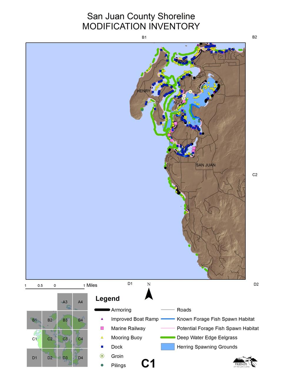
1 Shoreline Modification Inventory for San Juan County, Washington Mud/Hunter Bay Region, Lopez July 2010 Friends of the San Juans P.O. Box 1344 Friday Harbor, WA
2 Shoreline Modification Inventory for San Juan County, Washington Acknowledgements Friends of the San Juans 2009 Shoreline Modification Inventory would not have possible without the assistance of many individuals and organizations. Field survey efforts and GIS database development was led by James Slocomb. Undergraduate interns Tiffany Stephens and Samantha Palace and community volunteers Rick Exstrom, Craig Green, John Ashoff, Mary Masters and Chuck Rust collectively provided over 400 hundred hours of field assistance. Primary funding was provided by The Washington State Salmon Recovery Funding Board with matching support from ESRI, Robert Trimble and Jensen s Shipyard.
3 Background With over 400 miles of shoreline located at the confluence of Puget Sound, Georgia Strait and the Strait of Juan de Fuca, the nearshore marine habitats of San Juan County (SJC) play a critical role in the regional ecosystem. Protection of nearshore habitat has been identified at the local and regional levels as the most important salmon recovery strategy for the San Juan Archipelago (Shared Strategy 2005). The same forage fish species and nearshore habitats of interest in salmon recovery are also vital to the protection and restoration of additional key marine species including six stocks of Puget Sound rockfish; multiple species of seabirds, including the federally threatened Marbled murrelet; and the federally threatened Southern Resident Killer Whale. Shore modifications, almost without exception, impact the ecological functioning of nearshore coastal systems and the proliferation of these structures has been viewed as one of the greatest threats (Thom et al. 1994). Modifications often result in the loss of the very feature that attracted coastal property owners in the first place, the beach (Fletcher et al. 1997). Bulkheads and other shore modifications that bury habitat, and limit bluff erosion and littoral sediment transport have led to major changes in sediment supply and associated changes in beach and habitat stability. The cumulative impact of human modifications to the shoreline may be far-reaching in terms of both habitat and existing human activities, particularly in the face of anticipated increases in the rate of sea level rise and storm induced erosion. Coastal geomorphic processes create and maintain the nearshore habitats upon which many Puget Sound species of concern rely, including forage fish spawning areas, and juvenile salmonid rearing and migratory habitats, among others (Fresh 2006, Penttila 2007, Johannessen and MacLennan 2007). A recent study by C. Rice (2006) documented the effects of shoreline modifications on Puget Sound beaches on surf smelt mortality. Results showed that anthropogenic alteration of the shoreline typically makes beaches less suitable for surf smelt embryo survival when compared with unmodified shores (Rice 2006). Loss of marine riparian areas is commonly associated with shoreline development and anthropogenically modified shores. Shoreline modification is identified as a top threat to the SJC marine ecosystem (SJC Marine Stewardship Area Plan 2007) and protection of unmodified habitat was a primary focus for the San Juan Initiative s ecosystem research. The San Juan Initiative s Case Study of 40 miles of marine shoreline within San Juan County documented a predominance of shore modifications along feeder bluffs, transport zones, accretion shoreforms and pocket beaches, which all provide habitat for important marine species including forage fish and eelgrass (Johannessen and MacLennan 2008). The location of most modifications along non rocky shorelines means that impacts are concentrated in areas important to forage fish spawning habitat and habitat forming processes. With just twelve miles of documented forage fish spawning habitat in SJC, improved protections are needed to ensure maintenance of these habitats over the long term. In 2007, Friends of the San Juans (FSJ) completed an Analysis of Shoreline Permit Activity in San Juan County ( ) and found that over 300 permits are granted each year by the County for shoreline structures, excluding houses (Whitman 2007). The analysis also found that no-net-loss and sensitive areas regulations adopted in the 1990 s have not reduced the number or rate of shoreline permits granted that impact priority nearshore habitats including eelgrass and documented forage fish spawning habitats (Whitman 2007). Permits
4 for expansion of existing armoring and new armoring at known surf smelt and Pacific sand lance spawning habitats and docks over eelgrass continue to be granted in SJC by both county and state regulators. The majority of shoreline development activity in San Juan County occurs through incremental single-family development and individual shoreline alterations. The magnitude of these impacts may only become evident cumulatively over time. To date, no attempt has been made to evaluate the cumulative impacts of incremental shoreline development. Without a complete inventory of San Juan County s existing shoreline modifications, it is not possible to understand the extent of the problem, identify priority restoration projects, and reduce future impacts. In 2009, FSJ conducted a boat-based inventory and mapping project of shoreline modifications for all 400+ miles of marine shoreline within San Juan County. Results show that the current level of impact to shoreline habitats is much higher than previously believed and that the vast majority of impacts are associated with residential shoreline development. Methods A shallow water field assessment of all marine shorelines was completed aboard a small boat. Field surveys were primarily conducted at mid to high tidal elevations, to support traveling in close proximity to the shorelines. Surveys were carried out from April to July of At each point where a shoreline modification was encountered, two data records (electronic and hard copy) were collected for each structure. Data collected included: GPS point; recorder name and region; date and waypoint; two georeferenced digital photos; and information on modification type, material, size, condition, design and tidal elevation. All survey records were collected from boat except for the following three extremely shallow locations: Buck Bay, Orcas Island, inner Fisherman s Bay, Lopez Island and False Bay, San Juan Island where data was collected from a combination of land reconnaissance and aerial photo interpretation. The basic data categories included: Armoring; Docks; Marinas/Jetties/Breakwaters; Improved Boat Ramps; Marine Railways; Groins; Moorings and Floats; Pilings and Other. Because of the high number of structures and the challenges with accurately locating and documenting pipes using the boat based field survey methodology, stormwater outflow pipes and stairs were not included in this inventory. However, armoring greater than 5 feet in lenth associated with outflows and stairs was recorded. At the end of each field day the memory cards were extracted from the camera and data collector and all data was transferred to the master map using the standard ESRI procedure for checking field data into the ArcGIS project. This allowed visual verification that the day s data was successfully integrated into the map. All data were then immediately backed up and paper copies of records stored chronologically. Because survey methodology records the location of all the observed objects just offshore of their true location, a combination of field records and aerial photo review were utilized to join each structure to the correct location and shoreline tax parcel. More detailed field to ArcGIS database methodology is provided in the associated database distribution DVD Readme.doc.
5 Results Just under 3,500 modifications were mapped, photographed and described and included: 710 armored beaches, 472 docks, 32 groins, 55 marine railways, 70 improved boat ramps, 50 marina/jetty/breakwater, 116 piling groupings and 191 other on-beach structures. Information on structure size, material, tidal elevation and collection were recorded where relevant to inform understanding of potential habitat impacts and support the identification and prioritization of restoration opportunities. Armoring A total of 710 individual records were recorded for shoreline armoring, covering over 18 linear miles of SJC s total marine shorelines. The minimum armor length recorded was 6.5 feet. Maximum armor length recorded in the 2009 inventory was 3,513 feet and the mean length of armoring was 137 feet. The majority of armoring (674 or 95%) was associated with residential bulkheads. Armoring was also associated with beach access (155), roads (51), boat ramps (20), stormwater outfalls (14), road ends (8), breakwaters (3), groins (3) and jettys (2). 1,096 shoreline tax parcels (24%) had armoring present in the 2009 surveys. As documented by the San Juan Initiative s Case Study (MacLennan and Johannessen 2008), armoring was concentrated on sand/gravel or soft, non-rock shorelines. When analyzed with tax parcels on the approximately 320 miles of rocky shorelines removed, the proportion of armored soft shore shoreline tax parcels increases to nearly half of shoreline parcels (49%). While just 4% of the total marine shorelines within San Juan County are armored, the percent armored jumps to 22.5% for the 80 miles of sand/gravel shorelines. The majority of shoreline armoring consists of large rock (505), followed by small rock (364), wood (182), creosote wood (56), concrete (140) and gabion basket (9) construction. While the majority of armoring was in good condition (483), a significant proportion (200) were in degraded or poor condition. The waterward toe of bulkhead elevations ranged from a minimum of -2 M.L.L.W. to a high of + 11 M.L.L.W., with a mean of +5.7 M.L.L.W. These results indicate that the majority of bulkheads are located where they are directly impacting intertidal habitats through burial. As one example of direct habitat impacts, forage fish spawning and incubation normally occurs on upper beach habitat within the +7 to +9 M.L.L.W tidal elevation zone (Moulton and Penttila 2001). In addition to direct burial impacts, lower elevation structures also typically have larger indirect effects such as increased erosion at the ends and toe of the structure, bulkhead associated vegetation removal and loss of fine sediments over time on the beach face. Docks A total of 472 docks (excluding marinas and large community docks) were documented along San Juan County s marine shorelines. Of these, 42 (8%) had grated floats and 17 (3%) had grated piers. 356 (77%) docks with creosote wood piles and/or decking were recorded. 39 (8%) docks were noted to be in poor condition. Groins Thirty two groins were documented along the marine shorelines of San Juan County. The lower elevation of all documented groins was below the water line at the time of the survey. Upper beach elevations of groin structures ranged from +2 M.L.L.W. to +9 M.L.L.W., with a mean of +3.8 M.L.L.W. Groin elevation can play an
6 important role in evaluating potential or likely impacts to habitat and habitat forming processes such as burial of forage fish spawning substrate and disruption of sediment transport. Marine Railways Fifty five marine railways were documented along the marine shorelines of San Juan County in the 2009 inventory. Boat Ramps Seventy improved boat ramps (includes permanent on beach structures such as concrete pads) were documented along the marine shorelines of San Juan County in the 2009 inventory. Marinas/Jettys/Breakwaters A total of fifty structures were classified as marinas/jetties/breakwaters, including a number of large community docks. Detailed information beyond the locational waypoint and digital photograph was not collected for this category of structure, a result of the cost/benefit ratio of survey effort required and low restoration potential. Pilings One hundred and sixteen groupings of pilings (not associated with another existing structure such as a dock or marina) were documented along San Juan County s marine shorelines, including 425 individual pilings. Piling material was overwhelmingly creosote (89%). Mooring Buoys and Floats A total of 1,914 mooring buoys and floats were recorded in the 2009 field inventory, including 1,835 buoys and 79 floats (not associated with a dock or marina), and average of 4.7 per linear marine shoreline mile. Data recorded for buoys was limited to GPS location. For floats, a GPS location and photo was collected. Other A total of 191 additional modifications were documented in the 2009 county-wide inventory of San Juan County s marine shorelines. Structures included on-beach items such as boathouses, hot tubs, patios, lime kilns etc. Following the field surveys, the other category was reviewed and reclassified into five categories including: Other Structure: functioning (65); Other Structure: derelict (51); Ferry (4); Platform (59) and Aquaculture (1). Key Findings 1. Current shoreline impact level in San Juan County is greater than previously believed, and comparable with other rural Puget Sound Counties. When looked at with other areas with comparable shoreline inventory data sets, San Juan County s current level of shoreline development is similar to other rural areas around Puget Sound, including Hood Canal, east Jefferson County and Whatcom County (outside of Bellingham City limits). As an example, for all shoreline
7 structures except buoys (buoy data not included in Point No Point Treaty Council assessment), San Juan County has an average of 4 modifications per marine shoreline mile, while Hood Canal to East Juan de Fuca (Union River to Dungeness Spit, including City of Port Townsend), has an average of 3 modification per marine shoreline mile (Point No Point Treaty Council 2003). In another example, the percentage of armored sand/gravel shorelines, with rocky shores removed, is also comparable: 22.5% sand/gravel shorelines armored in San Juan County; 18% sand/gravel shorelines armored in Hood Canal to east Juan de Fuca (Point No Point Treaty Council 2003) and 18% sand/gravel shorelines armored in rural Whatcom County (excluding City of Bellingham) (Whatcom County 2006). 2. Impacts concentrated on non-rocky shorelines As documented by the San Juan Initiative s Case Study investigation of 40 miles of marine shorelines within four regions of San Juan County (Johannessen and MacLennan 2008), FSJ s 2009 modification inventory found a predominance of shore modifications along not just feeder bluffs but also along transport zones, accretion shoreforms and pocket beaches, which all provide habitat for important marine species. The location of most modifications along non rocky shorelines means that impacts are concentrated in areas important to key species and processes such as forage fish spawning habitat and habitat forming processes. With the majority of impacts concentrated along just 20% of the total marine shoreline miles in San Juan County (remaining 80% is rocky shore), significantly improved protections will be needed to address cumulative impacts to these shore types. 3. Significant restoration opportunities exist Process-based restoration has been recognized as the ideal means of restoring Puget Sound nearshore environments (Leschine and Petersen 2007, Johannessen and MacLennan 2007, Shared Strategy 2005). Processbased restoration attempts to restore and protect those self-sustaining processes that support the ongoing maintenance of habitats on a landscape scale. The connections between coastal processes and nearshore habitats is complex and occurs at multiple spatial and temporal scales, all of which require detailed information on the location and extent of habitats and human impacts as well as adequate policy language to effectively manage development and protect natural resources. Many degraded, outdated or unnecessary shoreline structures were documented in the 2009 Shoreline Modification Inventory for San Juan County. Collection of detailed size, material and condition data will support future restoration prioritization and landowner outreach efforts by FSJ and others. For example, the high number of degraded bulkheads presents a significant opportunity to restore habitat through structure removal where feasible or enhance habitat by rebuilding structures (higher beach elevation, smaller beach footprint using modern design standards, replacement of hard armor structure with soft shore protection methods, etc.). This fall, FSJ, with the involvement of an interdisciplinary technical team, will analyze shoreline modification inventory results with spatial species and habitat data to identify and prioritize shoreline restoration projects at the county scale. Project results will be used to inform San Juan County salmon recovery efforts. FSJ will also conduct significant landowner outreach efforts at potential restoration sites to identify interested landowners for voluntary restoration efforts.
8 4. Significant protection challenges ahead Despite the fact that approximately half of the shoreline tax parcels within San Juan County have not yet been developed with a residence, 40% of shoreline parcels already have a shoreline modification. As demand for additional shoreline structures will come from already developed parcels as well as newly developed shoreline lots, rates of impact are likely to increase over time. In addition, recent analysis of County permit trends indicates that the rate of armoring permitted through the Shoreline Exemption process is rapidly increasing. This situation is expected to be further exacerbated by the combined variables of sea level rise and associated increases in storminess, demand by property owners to fortify existing structures and the ongoing permitting of residential structures within close proximity to marine shorelines. While considered a rural county, shoreline tax parcel sizes within San Juan County are more closely associated with suburban levels of development. With shoreline natural areas and parks removed, the mean or average size of marine shoreline tax parcels within the county is 5.37 acres, the median or middle value is 1.32 acres, and the mode or most common value is 0.68 acres. With over 4,600 current marine shoreline tax parcels, the cumulative impacts of shoreline modifications are likely to be large, unless significant management improvements are made that change the current shoreline modification development patterns. Conclusions While each individual shoreline modification may not be negatively impacting habitat, and all are not avoidable, many are negatively impacting habitat, and many are avoidable. FSJ s Shoreline Modification Inventory results indicate that the cumulative impacts of current shoreline development to marine habitats and habitat forming processes are likely significant. In the face of declining marine species and habitats and increasing human populations and shoreline development pressures, coordinated and improved protection at the local, state and federal level will be required to meet the multiple objectives of no net loss of habitat function, endangered species recovery and property protection. Understanding of current on-the-ground conditions, and the likely cumulative impacts of the current level of shoreline modification, is needed to efficiently and effectively plan both restoration and protection programs.
9 References Fletcher, C.H., R.A. Mullane, B.M. Richmond, Beach loss along armored shoreline on Oahu, Hawaiian Islands, Journal of Coastal Research, vol. 13, no. 1, p Fresh, K.L Juvenile Pacific Salmon in Puget Sound. Puget Sound Nearshore Partnership Report No Published by Seattle District, U.S. Army Corps of Engineers, Seattle, Washington. Johannessen, J. and A. MacLennan Beaches and Bluffs of Puget Sound. Puget Sound Nearshore Partnership Report No Published by Seattle District, U.S. Army Corps of Engineers, Seattle, Washington. Leschine, T.M. and A.W. Petersen Valuing Puget Sound s Valued Ecosystem Components. Puget Sound Nearshore Partnership Report No Published by Seattle District, U.S. Army Corps of Engineers, Seattle, Washington. MacLennan, A.J., J. W. Johannessen, San Juan Initiative Protection Assessment Nearshore Case Study Area Characterization, Final Report Prepared for The San Juan Initiative; The Puget Sound Partnership through The Surfrider Foundation, 54 p. plus appendices. Moulton, L. L. and D. E. Penttila, Field manual for sampling forage fish spawn in intertidal shore regions and the Distribution of potential surf smelt and Pacific sand lance spawning habitat in San Juan County. MJM Research and Washington Department of Fish and Wildlife for the San Juan County Forage Fish Project. Penttila, D Marine Forage Fishes in Puget Sound. Puget Sound Nearshore Partnership Report No Published by Seattle District, U.S. Army Corps of Engineers, Seattle, Washington. Point No Point Treaty Council Shoreline alterations in Hood canal and the Eastern Strait of Juan de Fuca. PNPTC Technical Report Kingston, WA. Rice, C Effects of Shoreline Modification on a Northern Puget Sound Beach: Microclimate and Embryo Mortality in Surf Smelt (Hypomesus pretiosus). Estuaries and Coasts. Vol 29, No. 1. p San Juan County Marine Resources Committee Marine Stewardship Area Conservation Action Plan. San Juan County and The Nature Conservancy, Friday Harbor, Washington. Shared Strategy Puget Sound Chinook salmon recovery plan. San Juan County Chapter. NOAA Fisheries and the State of Washington. Seattle, Washington. Thom, R., Shreffler, D., and Macdonald, Keith, Shoreline armoring effects on coastal ecology and biological resources in Puget Sound, Washington: Coastal Erosion Management Studies. Whatcom County Shoreline Master Program Update Background Information Volume 1. Shoreline Inventory and Characterization. Whatcom County Planning and Development Services, Parametrix and Adolfson Associates. Whitman, T Analysis of Shoreline Permit Activity in San Juan County, Washington ( ). Friends of the San Juans. Friday Harbor, WA.

10
11

12

13

14

15

16
17

18

19

20

21

22

23

24
San Juan County Shoreline Modification Inventory Restoration Opportunities Report
 San Juan County Shoreline Modification Inventory Restoration Opportunities Report June 2011 www.sanjuans.org San Juan County Shoreline Modification Inventory Restoration Opportunities Report Coastal geomorphic
The Cumulative Effects of Shoreline Armoring on Forage Fish Spawning Beach Habitat in San Juan County, Washington.
 The Cumulative Effects of Shoreline Armoring on Forage Fish Spawning Beach Habitat in San Juan County, Washington. Tina Whitman, Science Director Friends of the San Juans August 2011 Prepared for the Bullitt
The Cumulative Impacts of Shoreline Armoring on Forage Fish Spawning Habitat in San Juan County, Washington
 Western Washington University Western CEDAR Salish Sea Ecosystem Conference 2014 Salish Sea Ecosystem Conference (Seattle, Wash.) May 1st, 1:30 PM - 3:00 PM The Cumulative Impacts of Shoreline Armoring
Analysis of Shoreline Permit Activity in San Juan County, Washington
 Analysis of Shoreline Permit Activity in San Juan County, Washington 1972-2005 Aerial Photo of Fisherman s Bay, Lopez Island by Mark Gardner Tina Whitman Friends of the San Juans P.O. Box 1344 Friday Harbor,
Puget Sound Shorelines. Waves and coastal processes. Puget Sound shorelines: Effects of beach armoring
 Puget Sound Shorelines Puget Sound shorelines: Effects of beach armoring Waves and coastal processes Factors affecting wave energy hitting the coast Processes transporting sediment along coastlines What
Thanks to: -Current and former Habitat staff -Fish Program Marine Fish Division & Region 6 Staff
 Thanks to: -Current and former Habitat staff -Fish Program Marine Fish Division & Region 6 Staff - Overview Intro to forage fish What they are and why are they important Nearshore Forage Fish Habitat surveys
Blakely Island, N Thatcher Bay. Restoration Recommendation: Rank Score (total score)
") Soft Shore Protection/Structure Removal Blueprint for San Juan County Forage Fish Beaches Appendix 2: Recommendations for sites scoring below the top ten, sorted by island (east to west) Blakely Island,
Soft Shore Protection/Structure Removal Blueprint for San Juan County Forage Fish Beaches Appendix 2: Recommendations for sites scoring below the top ten, sorted by island (east to west) Blakely Island,
Puget Sound Nearshore Ecosystem Restoration Project Restore America s Estuaries Conference 2012 Tampa, FL
 Restore America s Estuaries Conference 2012 Tampa, FL presented by: Theresa Mitchell, WA Dept. of Fish & Wildlife Nearshore General Investigation Change Analysis: Comparison of historical and current
The Blue Heron Slough Conservation Bank
 1 The Blue Heron Slough Conservation Bank CONSERVATION BANKING July 19-23, 2010 CASE STUDY SERIES The Blue Heron Slough Conservation Bank (Washington) I. OVERVIEW & BACKGROUND: Location: Snohomish River
living with the shoreline A Stewardship Guide for San Juan County Property Owners
 living with the shoreline A Stewardship Guide for San Juan County Property Owners living with the shoreline A Stewardship Guide for San Juan County Property Owners The San Juan Islands and the Northwest
New Jersey Coastal Zone Overview. The New Jersey Beach Profile Network (NJBPN) 3 Dimensional Assessments. Quantifying Shoreline Migration
 3 Dimensional Assessments. Quantifying Shoreline Migration") New Jersey Coastal Zone Overview The New Jersey Beach Profile Network (NJBPN) Objectives Profile Locations Data Collection Analyzing NJBPN Data Examples 3 Dimensional Assessments Methodology Examples Quantifying
New Jersey Coastal Zone Overview The New Jersey Beach Profile Network (NJBPN) Objectives Profile Locations Data Collection Analyzing NJBPN Data Examples 3 Dimensional Assessments Methodology Examples Quantifying
Proposed Terrestrial Critical Habitat for the Northwest Atlantic Loggerhead Sea Turtle Population. U.S. Fish and Wildlife Service
 Proposed Terrestrial Critical Habitat for the Northwest Atlantic Loggerhead Sea Turtle Population U.S. Fish and Wildlife Service History of Loggerhead Listing (joint responsibility USFWS and NOAA Fisheries)
SUCCESSFUL GEAR RECOVERY Lessons from Puget Sound
 APEC MARINE DEBRIS SEMINAR SUCCESSFUL GEAR RECOVERY Lessons from Puget Sound Jeff June, Project Manager Joe Schmitt & Gary Wood JD Northwest Straits Commission Washington State, U.S. The Northwest Straits
Concept for a Whale Protection Zone for the Endangered Southern Resident Killer Whale
 Concept for a Whale Protection Zone for the Endangered Southern Resident Killer Whale Supported (in part) by the Charlotte Martin Foundation and the Norcliffe Foundation The concept described in this document
USE OF SEGMENTED OFFSHORE BREAKWATERS FOR BEACH EROSION CONTROL
 .. CETN-III-22 4/84 PURPOSE: USE OF SEGMENTED OFFSHORE BREAKWATERS FOR BEACH EROSION CONTROL To provide information on the functional application of and general design considerations for using offshore
11426 Moorage Way P.O. Box 368 LaConner, WA Phone: Fax:
 Skagit River System Cooperative 11426 Moorage Way P.O. Box 368 LaConner, WA 98257-368 Phone: 36-466-7228 Fax: 36-466-447 www.skagitcoop.org BULL TROUT USE OF SWINOMISH RESERVATION WATERS Eric Beamer, Rich
Estuarine Shoreline Stabilization
 Estuarine Shoreline Stabilization Property Owner s Guide to Determining the Most Appropriate Stabilization Method Estuarine shorelines are dynamic features that experience continued erosion. Land is lost
FISH PASSAGE IMPROVEMENT in California s Watersheds. Assessments & Recommendations by the Fish Passage Forum
 FISH PASSAGE IMPROVEMENT in California s Watersheds Assessments & Recommendations by the Fish Passage Forum FISH PASSAGE IMPROVEMENT in California s Watersheds The mission of the Fish Passage Forum is
APPLICANT: Pacific Northwest National Laboratory Attention: Mr. Charles Brandt 1529 West Sequim Bay Road Sequim, Washington 98382
 US Army Corps of Engineers Seattle District Joint Public Notice Application for a Department of the Army Permit and a Washington Department of Ecology Water Quality Certification and/or Coastal Zone Management
Essential Fish Habitat OCNMS Advisory Council July 13, 2013
 Essential Fish Habitat OCNMS Advisory Council July 13, 2013 John Stadler Habitat Conservation Division NMFS Northwest Region Essential Fish Habitat (EFH) What is it, where did it come from, and what does
Inventory and Mapping of City of Seattle Shorelines along Lake Washington, the Ship Canal, and Shilshole Bay
 SAFS-UW-0302 April 2003 Inventory and Mapping of City of Seattle Shorelines along Lake Washington, the Ship Canal, and Shilshole Bay J TOFT, C SIMENSTAD, C YOUNG, L STAMATIOU Wetland Ecosystem Team University
MUCKLESHOOT INDIAN TRIBE Fisheries Division nd Avenue SE Auburn, Washington Phone: (253) Fax: (253)
 Fax: (253)") MUCKLESHOOT INDIAN TRIBE Fisheries Division 39015-172nd Avenue SE Auburn, Washington 98092-9763 Phone: (253) 939-3311 Fax: (253) 931-0752 U.S. Army Corps of Engineers Regulatory Branch Attn: Karen Urelius
MUCKLESHOOT INDIAN TRIBE Fisheries Division 39015-172nd Avenue SE Auburn, Washington 98092-9763 Phone: (253) 939-3311 Fax: (253) 931-0752 U.S. Army Corps of Engineers Regulatory Branch Attn: Karen Urelius
ALTERNATIVES FOR COASTAL STORM DAMAGE MITIGATION
 ALTERNATIVES FOR COASTAL STORM DAMAGE MITIGATION Dave Basco Old Dominion University, Norfolk, Virginia, USA National Park Service Photo STRUCTURAL (changes to natural, physical system) hardening (seawalls,
Lake Tahoe Shoreline Plan. 05 Policy Topic: Piers- Fish Habitat, Design, and Scenic Issues
 Lake Tahoe Shoreline Plan 05 Policy Topic: Piers- Fish Habitat, Design, and Scenic Issues 07.20.2016 1 Brief Description There are 768 piers located along the shoreline of Lake Tahoe. Approximately 43
Perspectives of a State Director Selective fisheries as a tool in fisheries management and salmon recovery
 Perspectives of a State Director Selective fisheries as a tool in fisheries management and salmon recovery Jeffrey P. Koenings, PhD. Washington Department of Fish and Wildlife American Fisheries Society
DRAFT TECHNICAL MEMORANDUM
 DRAFT TECHNICAL MEMORANDUM From: File No.: 213.001 Re: Beaux Arts Village Shoreline - 2016 Introduction The Washington Academy of Beaux Arts (WABA) completed shoreline habitat restoration at three locations
Orange County MPA Watch A n n u a l R e p o r t
 Orange County MPA Watch 2 0 1 4 A n n u a l R e p o r t WHAT IS AN MPA? Marine Protected Areas (MPAs) are discrete geographic marine or estuarine areas designed to protect or conserve marine life and habitat.
Use of Conservation Moorings as a Component of Eelgrass Restoration in two Massachusetts Harbors
 Use of Conservation Moorings as a Component of Eelgrass Restoration in two Massachusetts Harbors Massachusetts Bays Program Division of Marine Fisheries Jay Baker, Tay Evans, Mass Bays Program MarineFisheries
Feasibility Study for Restoration of Titlow Lagoon Fish Passage. South Puget Sound Salmon Enhancement Group
 Feasibility Study for Restoration of Titlow Lagoon Fish Passage South Puget Sound Salmon Enhancement Group January 2010 Feasibility Study for Restoration of Titlow Lagoon Fish Passage Prepared for South
Nearshore Habitat Mapping in Puget Sound Using Side Scan Sonar and Underwater Video
 Nearshore Habitat Mapping in Puget Sound Using Side Scan Sonar and Underwater Video Dana Woodruff, Paul Farley, Amy Borde, John Southard, Ron Thom Battelle Marine Sciences Laboratory Jim Norris Marine
INTRODUCTION TO COASTAL ENGINEERING
 The University of the West Indies Organization of American States PROFESSIONAL DEVELOPMENT PROGRAMME: COASTAL INFRASTRUCTURE DESIGN, CONSTRUCTION AND MAINTENANCE A COURSE IN COASTAL DEFENSE SYSTEMS I CHAPTER
Oregon Department of Fish and Wildlife: Inland Fisheries - Hatchery Management
 Oregon Department of Fish and Wildlife: Inland Fisheries - Hatchery Management Primary Outcome Area: Economy & Jobs Secondary Outcome Area: Healthy Environments Program Contact: Ed Bowles, 503-947-6206
Essential Fish Habitat
 Pacific Fishery Management Council Fact sheet: Essential Fish Habitat Habitat is the environment where an animal lives, feeds, and reproduces. Identifying fish habitat is complex because fish move through
Redondo Beach Boat Launch Ramp Facility
 Redondo Beach Boat Launch Ramp Facility Feasibility Report for the California Department of Boating and Waterways 2015 Grant Cycle For the City of Redondo Beach Submitted by March 13, 2014 Table of Contents
Chagrin River TMDL Appendices. Appendix F
 Appendix F The following are excerpts from the Eastern Brook Trout Joint Venture s Conservation Strategy (Working Draft v.6), Conserving the Eastern Brook Trout: Strategies for Action Found at: http://www.easternbrooktrout.org/constrategy.html
Free fish and invertebrate ID classes gets SCUBA divers involved in marine conservation
 Proceedings of the 2007 Georgia Basin Puget Sound Research Conference, Vancouver, BC pg. 1 Free fish and invertebrate ID classes gets SCUBA divers involved in marine conservation Janna Nichols, Anne Stoltz,
Friends of Semiahmoo Bay Society
 Friends of Semiahmoo Bay Society Marine Conservation Initiative Boundary Bay Intertidal Forage Fish Spawning Habitat Project Summary of the Project and Findings July 2006 October 2007 Funding Provided
Mid-Columbia Fisheries Enhancement Group Annual Report Fiscal Year 06: July 1, 2005 June 30, 2006
 Mid-Columbia Fisheries Enhancement Group Annual Report Fiscal Year 06: July 1, 2005 June 30, 2006 Mission Statement The mission of the Mid-Columbia Fisheries Enhancement Group is to restore self-sustaining
APPROVED WORK WINDOWS FOR FISH PROTECTION FOR ALL MARINE/ESTUARINE AREAS. excluding THE MOUTH OF THE COLUMBIA RIVER (BAKER BAY)
") APPROVED FOR FISH PROTECTION FOR ALL MARINE/ESTUARINE AREAS excluding THE MOUTH OF THE COLUMBIA RIVER (BAKER BAY) BY August 21, 2017 (1) The general work window is given by Tidal Reference Area. Figure
APPROVED FOR FISH PROTECTION FOR ALL MARINE/ESTUARINE AREAS excluding THE MOUTH OF THE COLUMBIA RIVER (BAKER BAY) BY August 21, 2017 (1) The general work window is given by Tidal Reference Area. Figure
Essential Fish Habitat Consultation
 1 Essential Fish Habitat Consultation Marine Shoreline Development Workshop February 21, 2007 John H. Stadler Washington State Habitat Office National Marine Fisheries Service Magnuson-Stevens Fishery
KUKUTALI PRESERVE JUVENILE CHINOOK SALMON AND FORAGE FISH ASSESSMENT
 KUKUTALI PRESERVE JUVENILE CHINOOK SALMON AND FORAGE FISH ASSESSMENT Eric Beamer, Josh Demma, and Rich Henderson Skagit River System Cooperative LaConner, WA March 2014 Report prepared for: Swinomish Indian
Beach profile surveys and morphological change, Otago Harbour entrance to Karitane May 2014 to June 2015
 Beach profile surveys and morphological change, Otago Harbour entrance to Karitane May 2014 to June 2015 Prepared for Port Otago Ltd Martin Single September 2015 Shore Processes and Management Ltd Contact
Eelgrass Survey Reporting Form 2222 Channel Road Newport Beach, CA Eelgrass (Zostera marina) Survey
 Survey") Eelgrass Survey Reporting Form 2222 Channel Road Newport Beach, CA 92660 Eelgrass (Zostera marina) Survey Survey Date: July 19th, 2013 Report Date: July 26 th, 2013 Prepared by: Coastal Resources Management,
Eelgrass Survey Reporting Form 2222 Channel Road Newport Beach, CA 92660 Eelgrass (Zostera marina) Survey Survey Date: July 19th, 2013 Report Date: July 26 th, 2013 Prepared by: Coastal Resources Management,
ALTERNATIVES FOR COASTAL STORM DAMAGE MITIGATION AND FUNCTIONAL DESIGN OF COASTAL STRUCTURES
 The University of the West Indies Organization of American States PROFESSIONAL DEVELOPMENT PROGRAMME: COASTAL INFRASTRUCTURE DESIGN, CONSTRUCTION AND MAINTENANCE A COURSE IN COASTAL DEFENSE SYSTEMS I CHAPTER
Project Webpage:
 Project Webpage: http://nature.ly/marinesatlanticbightera Coastal Data and Full Metadata: http://easterndivision.s3.amazonaws.com/marine/sab MA/SABMACoastalEcosystems.zip Coastal Chapter: http://easterndivision.s3.amazonaws.com/marine/sab
Oregon Estuaries defined: (Goal 16)
") Bob Bailey, Manager, Oregon Coastal Management Program Oregon Estuaries defined: (Goal 16) includes estuarine water, tidelands, tidal marshes, and submerged lands. Estuaries extend upstream to the head
Bob Bailey, Manager, Oregon Coastal Management Program Oregon Estuaries defined: (Goal 16) includes estuarine water, tidelands, tidal marshes, and submerged lands. Estuaries extend upstream to the head
ESTIMATED RETURNS AND HARVEST OF COLUMBIA RIVER FALL CHINOOK 2000 TO BY JOHN McKERN FISH PASSAGE SOLUTIONS
 ESTIMATED RETURNS AND HARVEST OF COLUMBIA RIVER FALL CHINOOK 2000 TO 2007 BY JOHN McKERN FISH PASSAGE SOLUTIONS ESTIMATED RETURNS AND HARVEST OF COLUMBIA RIVER FALL CHINOOK 2000 TO 2007 This analysis of
Patterns of Southern Resident Killer Whale (Orcinus orca) Movement in Relation to the Tides and Currents
 Movement in Relation to the Tides and Currents") Patterns of Southern Resident Killer Whale (Orcinus orca) Movement in Relation to the Tides and Currents Erin M. Soucy Beam Reach Marine Science and Sustainability School 620 University Road Friday Harbor,
Patterns of Southern Resident Killer Whale (Orcinus orca) Movement in Relation to the Tides and Currents Erin M. Soucy Beam Reach Marine Science and Sustainability School 620 University Road Friday Harbor,
Klickitat County Shoreline Master Program Update. Open House March 15, 2017
 Klickitat County Shoreline Master Program Update Open House March 15, 2017 Agenda 6:00 6:10 Welcome 6:10 6:40 Presentation SMP Update Process Shoreline Analysis review 6:40 8:00 Open House Topics SMP Process
Three point plan to addressing land use and habitat loss impacts on Chesapeake Bay tidal fish and shellfish
 Three point plan to addressing land use and habitat loss impacts on Chesapeake Bay tidal fish and shellfish 1. Establish Principles for Protection of Chesapeake Bay Fish and Shellfish The Fisheries GIT
Commercial Anchovy Fishery Public Meeting
 Commercial Anchovy Fishery Public Meeting February 15, 2017 Astoria, Oregon Cyreis Schmitt Troy Buell Maggie Sommer 1 Northern Anchovy Anchovy Ecology and Life History Federal and State Anchovy Management
CHAPTER 8 ASSESSMENT OF COASTAL VULNERABILITY INDEX
 124 CHAPTER 8 ASSESSMENT OF COASTAL VULNERABILITY INDEX 8.1 INTRODUCTION In order to assess the vulnerability of the shoreline considered under this study against the changing environmental conditions,
PUBLIC EXHIBITION OF COASTAL ZONE MANAGEMENT PLAN FOR COLLAROY-NARRABEEN BEACH AND FISHERMANS BEACH
 ITEM 8.3 REPORTING MANAGER TRIM FILE REF 2014/110936 ATTACHMENTS PUBLIC EXHIBITION OF COASTAL ZONE MANAGEMENT PLAN FOR COLLAROY-NARRABEEN BEACH AND FISHERMANS BEACH GROUP MANAGER NATURAL ENVIRONMENT 1
HARBOR INFRASTRUCTURE INVENTORIES Marquette Harbor, Michigan
 HARBOR INFRASTRUCTURE INVENTORIES Marquette Harbor, Michigan Harbor Location: Marquette Harbor is located in Marquette Bay on the south shore of Lake Superior, 160 miles west of Sault Ste. Marie, MI and
EXHIBIT ARWA-700 TESTIMONY OF PAUL BRATOVICH
 EXHIBIT ARWA-700 TESTIMONY OF PAUL BRATOVICH 1. I am a fisheries biologist employed by the firm of HDR, Inc. I hold a Bachelor of Science degree in Fisheries from the University of Washington, located
Okanagan Sockeye Reintroduction
 Okanagan Sockeye Reintroduction Backgrounder Elders accounts, and other forms of Traditional Ecological Knowledge (TEK) tell us that many species of salmon once came into the Okanagan Valley and tell us
FISHERIES BLUE MOUNTAINS ADAPTATION PARTNERSHIP
 FISHERIES A warming climate, by itself, substantially affects the hydrology of watersheds in the Blue Mountains. Among the key hydrologic changes projected under all scenarios for the 2040s and beyond
AN OVERVIEW OF RECENT PROJECTS RELATED TO SAND BUDGETS, SOUTHERN CALIFORNIA BEACHES
 AN OVERVIEW OF RECENT PROJECTS RELATED TO SAND BUDGETS, SAND SUPPLY, COASTAL ARMORING, MANAGEMENT, AND VALUING SOUTHERN CALIFORNIA BEACHES Dr. Kiki Patsch California State University Channel Islands Environmental
Orange County MPA Watch M o n i t o r i n g H u m a n U s a g e
 Orange County MPA Watch M o n i t o r i n g H u m a n U s a g e WHAT IS AN MPA? Marine Protected Areas (MPAs) are discrete geographic marine or estuarine areas designed to protect or conserve marine life
Discussion Paper: February 15, 2018
 Discussion Paper: February 15, 2018 Proposed 2018 Salmon Fishery Management Measures to Support Chinook Salmon Prey Availability for Southern Resident Killer Whales Contents 1. Purpose... 2 1.0 Background...
Lake Tahoe Shoreline Plan 05 Policy Topic: Piers- Fish Habitat, Design, and Scenic Issues
 Lake Tahoe Shoreline Plan 05 Policy Topic: Piers- Fish Habitat, Design, and Scenic Issues V8 Last Updated 03.14.2017 1 Brief Description There are 768 piers located along the shoreline of Lake Tahoe. Approximately
STATUS REPORT FOR THE SUBMERGED REEF BALL TM ARTIFICIAL REEF SUBMERGED BREAKWATER BEACH STABILIZATION PROJECT FOR THE GRAND CAYMAN MARRIOTT HOTEL
 August 23 STATUS REPORT FOR THE SUBMERGED REEF BALL TM ARTIFICIAL REEF SUBMERGED BREAKWATER BEACH STABILIZATION PROJECT FOR THE GRAND CAYMAN MARRIOTT HOTEL performed by Lee E. Harris, Ph.D., P.E. Consulting
EVALUATING THE EFFECTS OF BIVALVE SHELLFISH AQUACULTURE AND ITS ECOLOGICAL ROLE IN THE ESTUARINE ENVIRONMENT IN THE UNITED STATES
 EVALUATING THE EFFECTS OF BIVALVE SHELLFISH AQUACULTURE AND ITS ECOLOGICAL ROLE IN THE ESTUARINE ENVIRONMENT IN THE UNITED STATES Brett Dumbauld USDA Agricultural Research Service, Hatfield Marine Science
Restoring the Kootenai: A Tribal Approach to Restoration of a Large River in Idaho
 Restoring the Kootenai: A Tribal Approach to Restoration of a Large River in Idaho Susan Ireland, Kootenai Tribe of Idaho Future of our Salmon Conference Technical Session August 2016 Healthy Floodplains,
Case study 64. Shoreham Harbour Shingle Bypassing and Recycling
 Case study 64. Shoreham Harbour Shingle Bypassing and Recycling Authors: Tony Parker, Uwe Dornbusch Main driver: Improved defences Project stage: Ongoing construction/operation since 1992 Photo 1: Shoreham
TITLE: North Carolina s Changing Shorelines. KEYWORDS: erosion - shorelines - mapping - sustainability
 UNC Coastal Studies Institute Teacher Resources 1 TITLE: North Carolina s Changing Shorelines KEYWORDS: erosion - shorelines - mapping - sustainability Changing shorelines impact coastal infrastructure.
Charter Boat Fishing in Lake Michigan: 2017 Illinois Reported Harvest
 Illinois Department of Natural Resources Division of Fisheries Charter Boat Fishing in Lake Michigan: 2017 Illinois Reported Harvest Steven R. Robillard Illinois Department of Natural Resources Lake Michigan
Habitat Development: Habitat Boulders Lawson Pier Foreshore Enhancement
 Habitat Development: Habitat Boulders Improve the existing habitat by stabilising beach sediments. Increase biodiversity by creating new habitats and colonisation opportunities. Loose cobble is unstable;
EVALUATION OF BEACH EROSION UP-DRIFT OF TIDAL INLETS IN SOUTHWEST AND CENTRAL FLORIDA, USA. Mohamed A. Dabees 1 and Brett D.
 EVALUATION OF BEACH EROSION UP-DRIFT OF TIDAL INLETS IN SOUTHWEST AND CENTRAL FLORIDA, USA Mohamed A. Dabees 1 and Brett D. Moore 1 The paper discusses the analysis of up-drift beach erosion near selected
POST PROJECT MONITORING REPORT FOR THE WASHINGTON HARBOR RESTORATION PROJECT
 POST PROJECT MONITORING REPORT FOR THE WASHINGTON HARBOR RESTORATION PROJECT Report Prepared by: Jamestown S Klallam Tribe 1033 Old Blyn Highway, Sequim WA 98382 (360) 681-4601 PA-00J32201-0 Submitted
Restoration of the Nisqually River Delta and increased rearing opportunities for salmonids
 Western Washington University Western CEDAR Salish Sea Ecosystem Conference 2014 Salish Sea Ecosystem Conference (Seattle, Wash.) May 2nd, 8:30 AM - 10:00 AM Restoration of the Nisqually River Delta and
Public Notice U.S. Army Corps In Reply to Application Number CENAB-OP-RMS (NATIONAL HARBOR (FORMERLY PORT Baltimore District AMERICA])
![Public Notice U.S. Army Corps In Reply to Application Number CENAB-OP-RMS (NATIONAL HARBOR (FORMERLY PORT Baltimore District AMERICA])](/thumbs/89/100795623.jpg "Public Notice U.S. Army Corps In Reply to Application Number CENAB-OP-RMS (NATIONAL HARBOR (FORMERLY PORT Baltimore District AMERICA])") Public Notice U.S. Army Corps In Reply to Application Number of Engineers CENAB-OP-RMS (NATIONAL HARBOR (FORMERLY PORT Baltimore District AMERICA]) 88-01361 PN 14-05 Comment Period: January 16, 2014 to
Public Notice U.S. Army Corps In Reply to Application Number of Engineers CENAB-OP-RMS (NATIONAL HARBOR (FORMERLY PORT Baltimore District AMERICA]) 88-01361 PN 14-05 Comment Period: January 16, 2014 to
Introduction Proposed Action
 Introduction The United States Navy s Naval Special Warfare Group THREE of the Naval Special Warfare Command proposes to conduct training at multiple Western Washington locations. The purpose of the training
Progress Made by Tuna Regional Fisheries Management Organizations (RFMOs)
") Progress Made by Tuna Regional Fisheries Management Organizations (RFMOs) Background Following the first joint meeting of the five tuna regional fisheries management organizations (RFMOs) in January 2007,
Progress Made by Tuna Regional Fisheries Management Organizations (RFMOs) Background Following the first joint meeting of the five tuna regional fisheries management organizations (RFMOs) in January 2007,
Nearshore Sediment Transport What influences the loss of sediment on Beaches? - Waves - Winds - Tidal Currents - River discharge - Runoff
 Tides & Beaches Nearshore Sediment Transport What influences the loss of sediment on Beaches? - Waves - Winds - Tidal Currents - River discharge - Runoff Oceans Ocean Topography Physical Structure of the
CHAPTER 4 DESIRED OUTCOMES: VISION, GOALS, AND OBJECTIVES
 CHAPTER 4 DESIRED OUTCOMES: VISION, GOALS, AND OBJECTIVES Vision One of the first steps in developing this Plan was articulating a vision - a clear statement of what the Plan strives to achieve and what
Estimated on-the-ground start and end dates: 1 June October 2018
 A. Applicant Information Name of Organization: U.S. Army Corps of Engineers, Carlyle Lake 801 Lake Road, Carlyle, IL 62231 Contact Information: Robert Wilkins, Operations Manager, (618) 594-2484, Robert.Wilkins@usace.army.mil
Skeena Salmon. Skeena Estuary. Estuary location. Introduction. Narrative. Total estuary area 1,802 km 2. Total Accessible Stream Length (km)
") Skeena Salmon Skeena Estuary Version 1.2, February 2014 Introduction This habitat report card was developed by the Pacific Salmon Foundation with technical support from ESSA Technologies. This project
Skeena Salmon Skeena Estuary Version 1.2, February 2014 Introduction This habitat report card was developed by the Pacific Salmon Foundation with technical support from ESSA Technologies. This project
COMMENTS ON SEATTLE DISTRICT 2017 NATIONWIDE PERMIT GENERAL REGIONAL CONDITIONS AND SPECIFIC REGIONAL CONDITIONS
 State of Washington DEPARTMENT OF FISH AND WILDLIFE Mailing Address: 600 Capitol Way N, Olympia, WA 98501-1091 (360) 902-2200 TDD (360) 902-2207 Main Office Location: Natural Resources Building, 1111 Washington
Living Shorelines Non-structural Erosion Control Practices Rhode Island Land & Water Summit, 2014
 Living Shorelines Non-structural Erosion Control Practices Rhode Island Land & Water Summit, 2014 D. Steven Brown (1) Kevin Ruddock (1) Rhonda Smith (2) The Nature Conservancy United States Fish and Wildlife
Dear Governor Inslee, Co-Chairs Solien and Purce, and Southern Resident Orca Recovery Task Force Members,
 October 15, 2018 Governor Jay Inslee Office of the Governor P.O. Box 40002 Olympia, WA 98504 Ms. Stephanie Solien, Co-Chair Mr. Thomas (Les) Purce, Co-Chair Southern Resident Killer Whale Task Force c/o
Environmental Protection on the Gold Coast of Queensland, Australia. 1. What is the appeal of the Gold Coast to tourists?
 Environmental Protection on the Gold Coast of Queensland, Australia Sections 1. What is the appeal of the Gold Coast to tourists? 2. How are Gold Coast visitor trends changing? 3. How can the impacts of
Fisheries Management Zone 10:
 Fisheries Management Zone 10: Lake Trout Operational Objectives and Management Photo Credit: www.jamessmedleyoutdoors.com 2 FMZ 10: Lake Trout Operational Objectives and Management Lake trout are the second
SACO RIVER AND CAMP ELLIS BEACH SACO, MAINE SECTION 111 SHORE DAMAGE MITIGATION PROJECT APPENDIX F ECONOMIC ASSESSMENT
 SACO RIVER AND CAMP ELLIS BEACH SACO, MAINE SECTION 111 SHORE DAMAGE MITIGATION PROJECT APPENDIX F ECONOMIC ASSESSMENT Department of the Army New England District, Corps of Engineers 696 Virginia Road
Black Sturgeon Regional Plan
 Black Sturgeon Regional Plan This is one of twenty Regional Plans that support implementation of the Lake Superior Biodiversity Conservation Strategy (Strategy). The Strategy, prepared and overseen by
X.B WETLANDS ROGUE RIVER ESTUARY
 X.B WETLANDS ROGUE RIVER ESTUARY The Rogue River has a drainage area of 5,100 square miles, yet the estuary of the Rogue River is one of the smallest in Oregon, measuring approximately 1,880 acres during
Time Will Tell: Long-term Observations of the Response of Rocky-Habitat Fishes to Marine Reserves in Puget Sound
 Time Will Tell: Long-term Observations of the Response of Rocky-Habitat Fishes to Marine Reserves in Puget Sound Wayne A. Palsson, Robert E. Pacunski, and Tony R. Parra Washington Department of Fish and
Town of Duck, North Carolina
 Tracking No. 00.00.2010 Erosion Mitigation And Shoreline Management Feasibility Study Town of Duck, North Carolina Coastal Planning & Engineering of North Carolina August 15, 2012 Tom Jarrett Robert Neal
East Kitsap Peninsula WRIA 15 Salmon Habitat Restoration Strategy Summary
 East Kitsap Peninsula WRIA 15 Salmon Habitat Restoration Strategy Summary I. Specificity and Focus of the Strategy Strategic Planning Area The planning area for the East Kitsap Peninsula Salmon Habitat
Maryland Chapter Trout Unlimited Brook Trout Conservation Effort
 Maryland Chapter Trout Unlimited Brook Trout Conservation Effort Photo by Matt Kline Portfolio of Recent Work MDTU Brook Trout Conservation Coordinator: Scott C. Scarfone, ASLA sscarfone@oasisdesigngroup.com
Employer Name: NOAA Fisheries, Northwest Fisheries Science Center
 Internship Description Employer Name: NOAA Fisheries, Northwest Fisheries Science Center Employer Description: Manchester Research Station functions as a satellite facility to the NOAA Fisheries Northwest
National Report on Large Whale Entanglements
 National Report on Large Whale Entanglements Confirmed in the United States in 2017 In 2017, 76 confirmed cases of large whale entanglements were documented along the coasts of the United States. Seventy
HURRICANE SANDY LIMITED REEVALUATION REPORT UNION BEACH, NEW JERSEY DRAFT ENGINEERING APPENDIX SUB APPENDIX D SBEACH MODELING
 HURRICANE SANDY LIMITED REEVALUATION REPORT UNION BEACH, NEW JERSEY DRAFT ENGINEERING APPENDIX SUB APPENDIX D SBEACH MODELING Rev. 18 Feb 2015 1 SBEACH Modeling 1.0 Introduction Following the methodology
Estuary & Salmon Restoration Program
 Estuary & Salmon Restoration Program Advancing Nearshore Protection and REStoration 2015 program report Overview The Estuary and Salmon Restoration Program (ESRP) provides funding and technical assistance
Chapter 4 EM THE COASTAL ENGINEERING MANUAL (Part I) 1 August 2008 (Change 2) Table of Contents. Page. I-4-1. Background...
 1 August 2008 (Change 2) Table of Contents. Page. I-4-1. Background...") Chapter 4 EM 1110-2-1100 THE COASTAL ENGINEERING MANUAL (Part I) 1 August 2008 (Change 2) Table of Contents I-4-1. Background... Page I-4-1 a. Shore Protection Planning and Design, TR 4... I-4-1 b. Shore
Chapter 4 EM 1110-2-1100 THE COASTAL ENGINEERING MANUAL (Part I) 1 August 2008 (Change 2) Table of Contents I-4-1. Background... Page I-4-1 a. Shore Protection Planning and Design, TR 4... I-4-1 b. Shore
Coastal and marine recreation in New England is ingrained in the region s economic and
 RECREATION Coastal and marine recreation in New England is ingrained in the region s economic and social fabric. Recreation on the ocean and coast includes many of New Englanders most time-honored and
FRIENDS. of the San Juans. Vessel Impacts from Coal & Tar Sands Oil Shipping Shoreline Master Program Informational Pull-Out
 FRIENDS of the San Juans Vessel Impacts from Coal & Tar Sands Oil Shipping Shoreline Master Program Informational Pull-Out Tsunamis Debris Reaches Local Shores Forage Fish and the Marine Food Web Protecting
Habitat Fact Sheets. Rocky habitats are dominated by seaweeds and often mussels, which rely on the rocks for attachment.
 Habitat Fact Sheets Habitats in the Gulf of Maine serve many important roles for the environment and for humans as well. These include: cycling nutrients, filtering pollution, trapping sediments, storing
State of San Francisco Bay 2011 Appendix O Steelhead Trout Production as an Indicator of Watershed Health
 State of San Francisco Bay 2011 Appendix O Steelhead Trout Production as an Indicator of Watershed Health Gordon Becker and Katherine Smetak, Center for Ecosystem Management and Restoration 290 Introduction
page - Laboratory Exercise #5 Shoreline Processes
 page - Laboratory Exercise #5 Shoreline Processes Section A Shoreline Processes: Overview of Waves The ocean s surface is influenced by three types of motion (waves, tides and surface currents). Shorelines