The Cumulative Effects of Shoreline Armoring on Forage Fish Spawning Beach Habitat in San Juan County, Washington.
|
|
|
- Merryl Manning
- 5 years ago
- Views:
Transcription


1 The Cumulative Effects of Shoreline Armoring on Forage Fish Spawning Beach Habitat in San Juan County, Washington. Tina Whitman, Science Director Friends of the San Juans August 2011 Prepared for the Bullitt Foundation
2 Introduction Forage fish play a key role in marine food webs, with a small number of species providing the trophic connection between zooplankton and larger fishes, squids, seabirds and marine mammals, including ESA listed species such as Chinook salmon and the marbled murrelet. Beach spawning forage fish such as surf smelt (Hypomesus pretiosus) and Pacific sand lance (Ammodytes hexapterus) are threatened by land use activities along shorelines, where development is also concentrated. Forage fish spawning areas in San Juan County (SJC) and throughout Puget Sound are especially vulnerable to the impacts of shoreline armoring. Sea level rise is expected to exacerbate the impacts of shoreline armoring on forage fish spawning habitat. In addition, sea level rise and other implications of climate change such as increased storminess are anticipated to result in the increased demand for new shoreline armoring, which will further compound forage fish spawning habitat loss and degrade the nearshore sediment sources or feeder bluffs that sustain nearshore habitats. The objective of this assessment was to investigate the cumulative effect shoreline armoring is having on the upper intertidal sand and gravel beach habitats required for spawning substrate by two key forage fish in the Puget Sound region, surf smelt and Pacific sand lance. The geographic scope of the project was San Juan County, Washington. Generous funding for this research was provided by the Bullitt Foundation. Background With over 400 miles of marine shoreline located at the confluence of Puget Sound, Georgia Strait and the Strait of Juan de Fuca, the nearshore marine habitats of SJC play an important role in regional salmon and orca recovery efforts. Bulkheads and other shore modifications that bury habitat and limit bluff erosion and littoral sediment transport have led to major changes in sediment supply and associated changes in beach and habitat stability. The cumulative impact of human modifications to the shoreline may be far-reaching in terms of both habitat and existing human activities, particularly in the face of anticipated increases in the rate of sea level rise and storm induced erosion. Coastal geomorphic processes create and maintain the nearshore habitats upon which many Puget Sound species of concern rely, including forage fish spawning areas, and juvenile salmonid rearing and migratory habitats, among others (Fresh 2006, Penttila 2007, Johannessen and MacLennan 2007). Shore modifications, almost without exception, impact the ecological functioning of nearshore coastal systems. The proliferation of these structures has been viewed as one of the greatest threats to the ecological functioning of coastal systems (Thom et al. 1994). Modifications often result in the loss of the very feature that attracted coastal property owners in the first place, the beach (Fletcher et al. 1997). With bulkheading and other shore modifications such as filling and dredging, net shore-drift input from bluffs is reduced and beaches become sediment starved. The installation of structures typically results in the direct burial of the backshore area and portions of the beach face, resulting in reduced beach width (Griggs 2005) and loss of habitat area (Bulleri and Chapman 2010). Beaches also become more coarse-grained as sand is 2
3 winnowed out and transported away. The beach is often converted to a gravel beach which does not provide the same quality of habitat as a finer grain beach (Thom et al. 1994, MacDonald 1994). Large woody debris (LWD) is usually also transported away from the shore following installation of bulkheads, with corresponding changes in habitat (Tonnes 2008). Habitats that are substantially impacted by shore modifications include forage fish (such as surf smelt and sand lance) spawning habitat. These habitat areas are only found in the upper intertidal portion of fine gravel and sand beaches, with a high percentage of 1-7 mm sediment (Penttila 1999), which is fine gravel (smaller than pea gravel) to coarse sand. Sand lance require mm sediment for spawning. Beach sediment coarsening can also affect hard-shell clam habitat, by decreasing or locally eliminating habitat. A recent study by C. Rice (2006) documented the effects of shoreline modifications on Puget Sound beaches on surf smelt mortality. Results showed that anthropogenic alteration of the shoreline typically makes beaches less suitable for surf smelt embryo survival when compared with unmodified shores (Rice 2006). Loss of marine riparian areas is commonly associated with shoreline development and anthropogenically modified shores. Shoreline modification was identified as a top threat to the SJC marine ecosystem (SJC Marine Stewardship Area Plan 2007) and protection of unmodified habitat was a primary focus for the San Juan Initiative s ecosystem research. In 2007, FSJ completed an Analysis of Shoreline Permit Activity in San Juan County ( ) and found that over 300 permits are granted each year for shoreline structures, excluding houses (Whitman 2007). The analysis also found that no-net-loss and sensitive areas regulations adopted in the 1990 s have not reduced the amount of shoreline permits granted that impact priority nearshore habitats including eelgrass and documented forage fish spawning habitats (Whitman 2007). Permits for expansion of existing armoring and new armoring of known surf smelt and Pacific sand lance spawning habitats also continue to be granted in SJC by both county and state regulators. In 2009, FSJ conducted a field-based inventory and mapping project of shoreline modifications for the 408 miles of marine shoreline within SJC. Results show that the current level of impact to shorelines is much higher than previously believed and that the vast majority of impacts are associated with residential shoreline development. Just under 3,500 individual modifications were mapped, photographed and described (size, material, condition, tidal elevation) and include: 710 armored beaches, 472 docks, 32 groins, 55 marine railways, 70 improved boat ramps, 50 marina/jetty/breakwater, and 191 other beach structures (boathouses, stormwater outflow pipes, patios etc.). Over 18 miles of SJC s total shoreline is armored; and 22.5% of the 80 miles of sand and gravel beaches are armored (the remaining 320+ miles of shoreline is rocky). As documented by the San Juan Initiative s Case Study (Johannessen and MacLennan 2008), there was a predominance of shore modifications along not just feeder bluffs but also along transport zones, accretion shoreforms and pocket beaches, which all provide habitat for important marine species. The location of most modifications along non rocky shorelines means that impacts are concentrated in areas important to forage fish spawning habitat and habitat forming 3
4 processes. With just ten miles of documented forage fish (surf smelt and Pacific sand lance) beach spawning habitat in SJC, improved protections are needed to ensure maintenance of these habitats over the long term. Process-based restoration has been recognized as the ideal means of restoring Puget Sound nearshore environments (Leschine and Petersen 2007, Johannessen and MacLennan 2007). Processed-based restoration attempts to restore and protect those self-sustaining processes that support the ongoing maintenance of habitats on a landscape scale. Eroding bluffs (commonly referred to as feeder bluffs ) contribute sediment to net shore-drift cells (along shore sediment sub-systems); replacing sediment that is continuously transported to maintain down-drift habitats such as spits and pocket estuaries. Protecting and enhancing physical processes along Puget Sound area beaches and bluffs is essential to sustaining, preserving, restoring and creating more resilient nearshore habitats (Shared Strategy 2005). The connections between coastal processes and nearshore habitats is complex and occurs at multiple spatial and temporal scales, all of which require adequate policy language to effectively protect or manage these resources. Methods A spatially explicit analysis was conducted using the following GIS data layers: documented forage fish spawning habitat, shoreline armoring, shoreform, and drift cell. Technical assistance in the development of project methodology was provided by Andrea MacLennan of Coastal Geologic Services, Dan Penttila of Salish Sea Biological and James Slocomb. GIS analysis and mapping was conducted by Sally Hawkins. Forage fish spawning habitat and armor were assessed for their relationship to shoreform, and to each other. In addition, known impacts to spawning habitat including direct burial, changes to sediment supply and sediment transport were evaluated. The presence or absence of marine riparian vegetation at documented spawning sites, and associated armored spawn sites, is also underway but was not completed in time for this report. Burial of spawning habitat was quantified by the linear shoreline length of impact of armor with a toe elevation at and below 9 feet Mean Lower Low Water (M.L.L.W.). A more detailed quantification would include an assessment of beach profile to support a calculation of the area of spawning habitat buried. Site specific field investigation of beach profiles was beyond the scope of this project, but should be considered for future work on this topic. Impacts to sediment supply, essential to formation and long term maintenance of the spawning substrate size range required by surf smelt and Pacific sand lance, were evaluated by the number and length of armoring of feeder bluffs, in drift cells with documented and potential spawning beaches. Impacts to sediment transport were evaluated by the number and length of shoreline armoring occurrences with a toe elevation below mean sea level (4.5 M.L.L.W. from NOAA Friday Harbor station applied countywide). 4
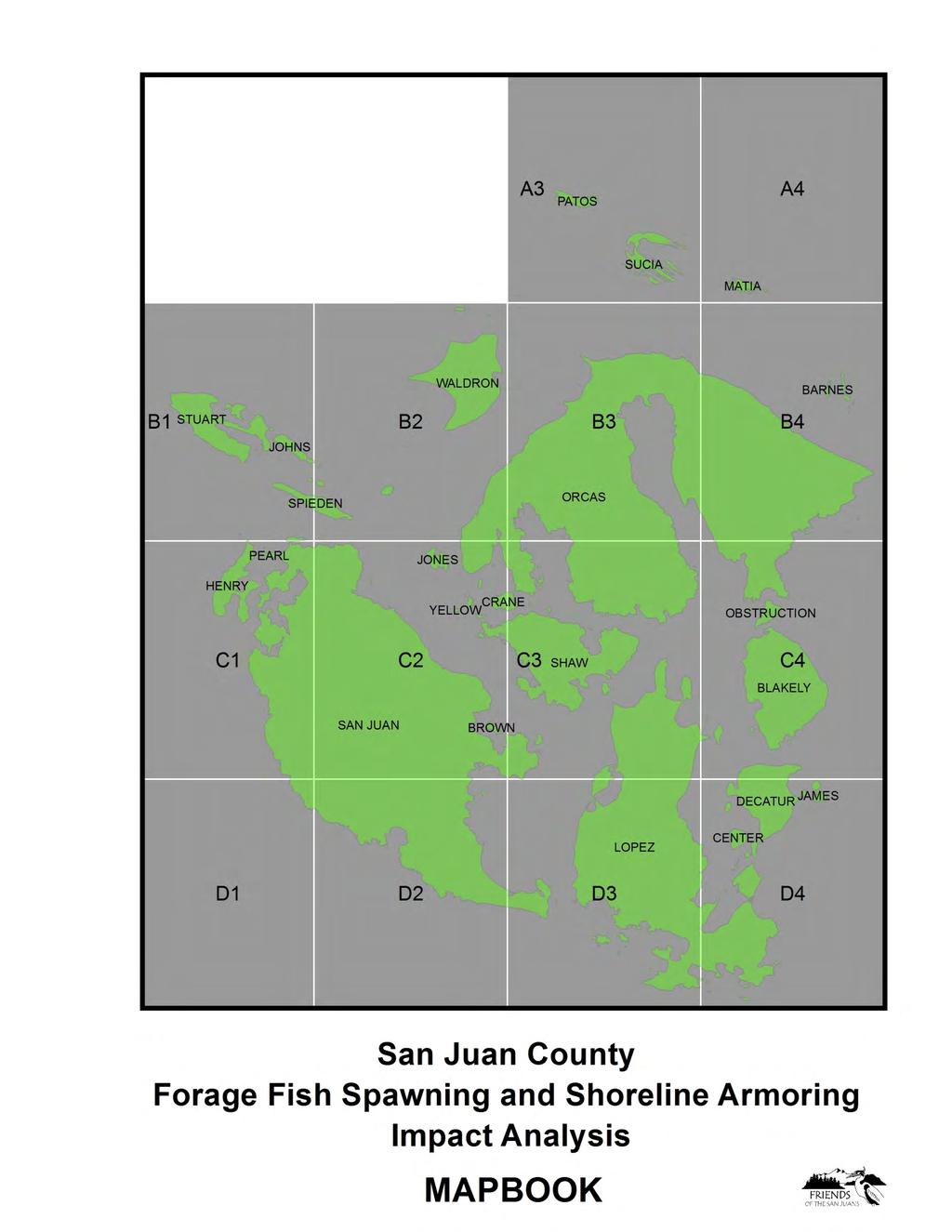
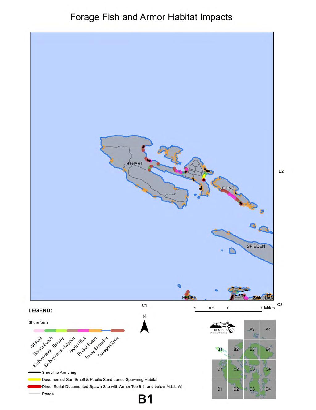
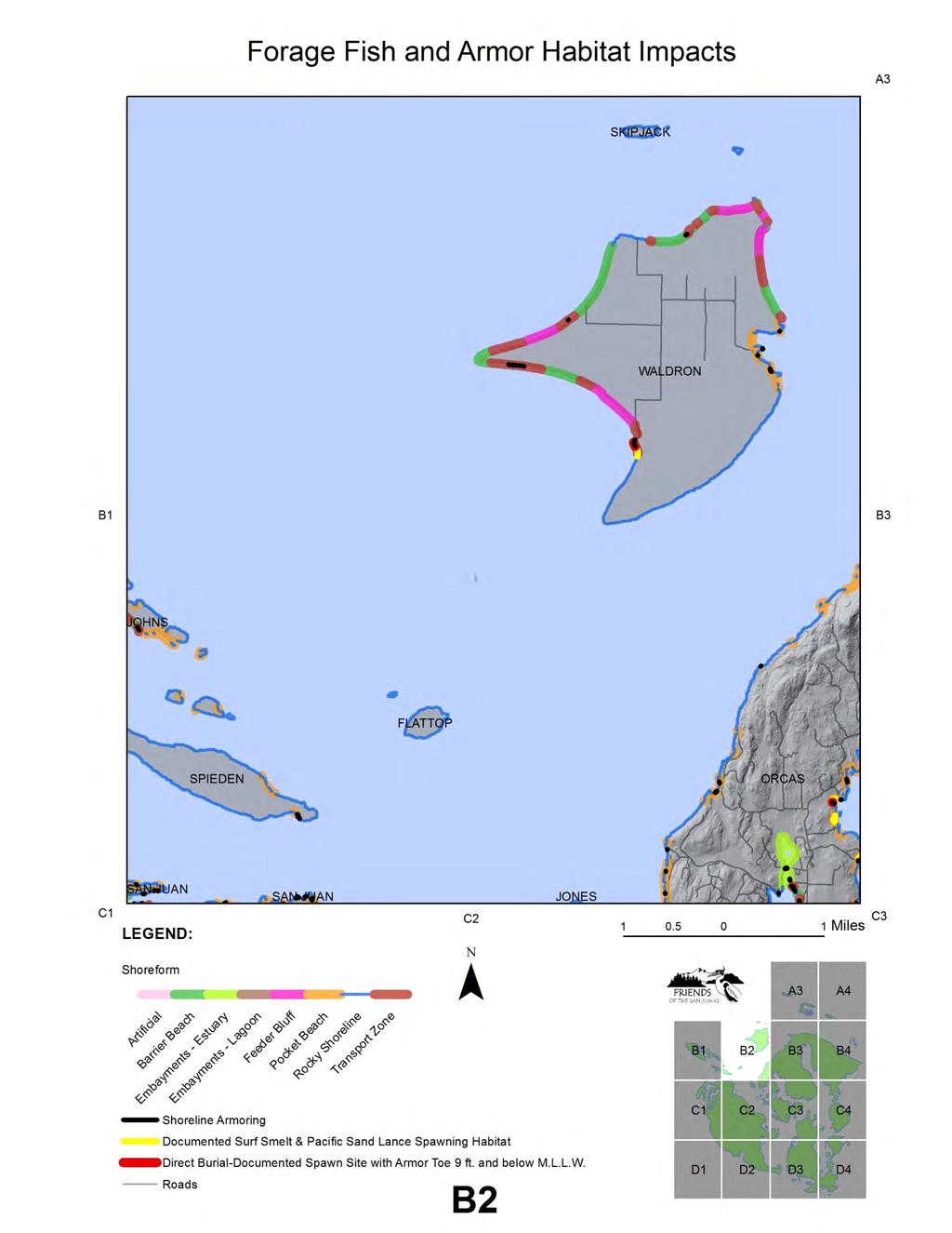
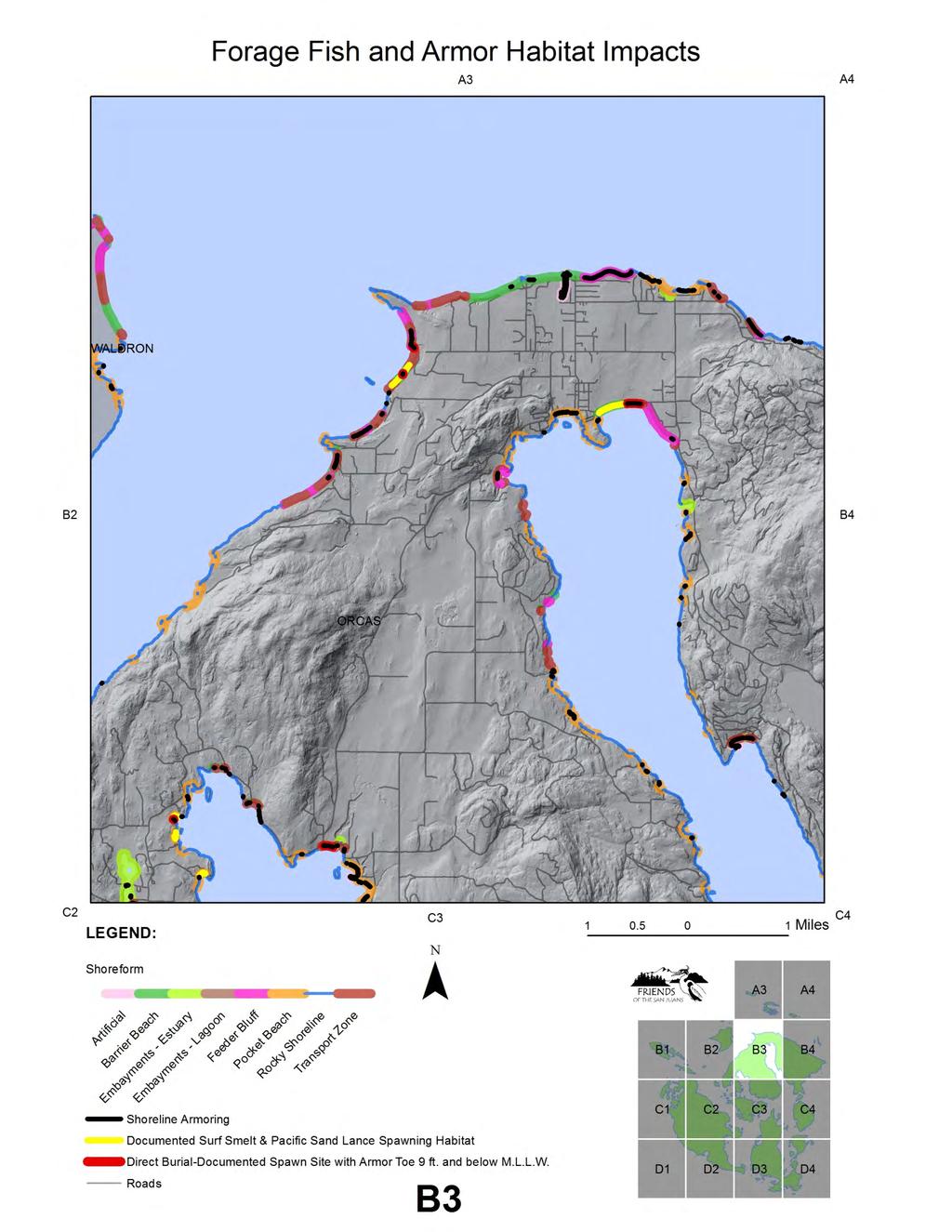
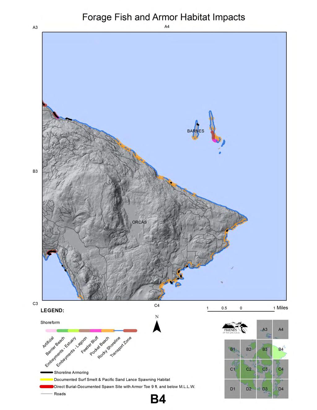
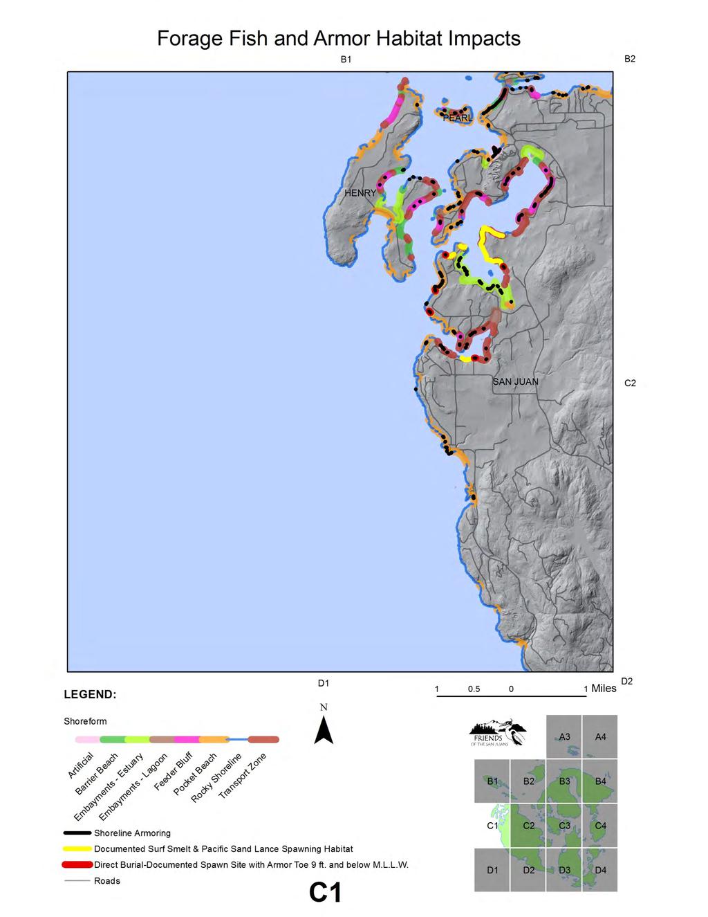
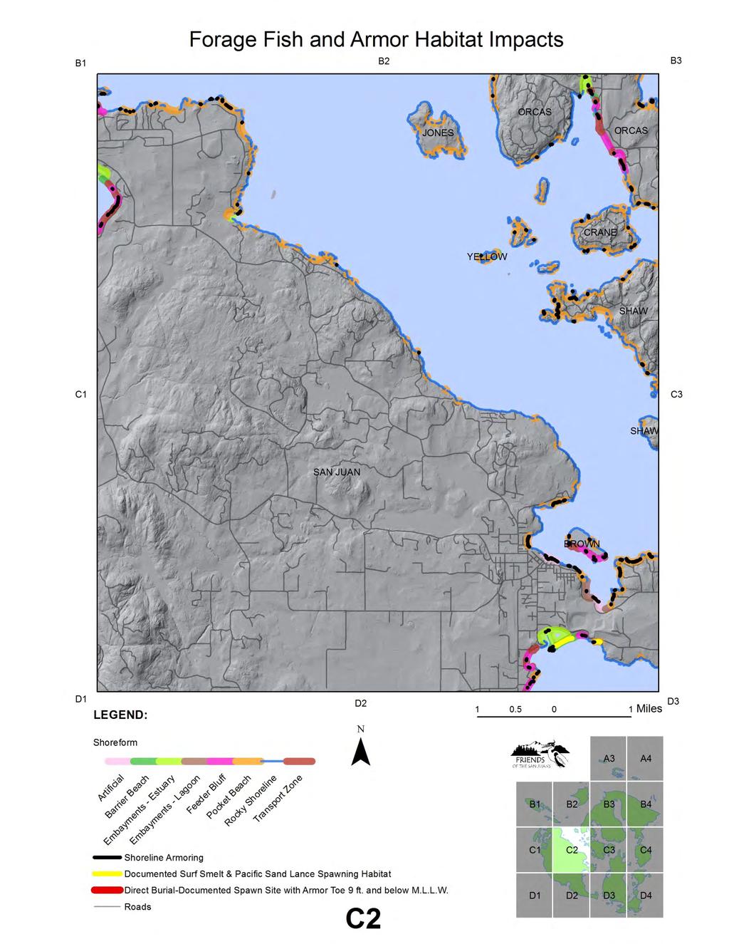
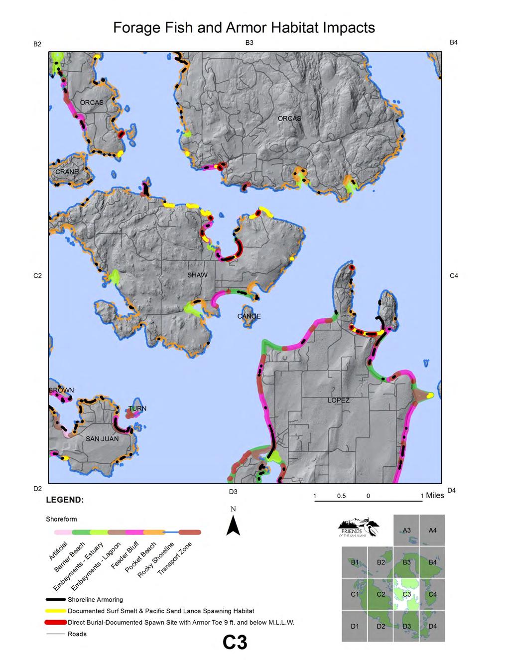
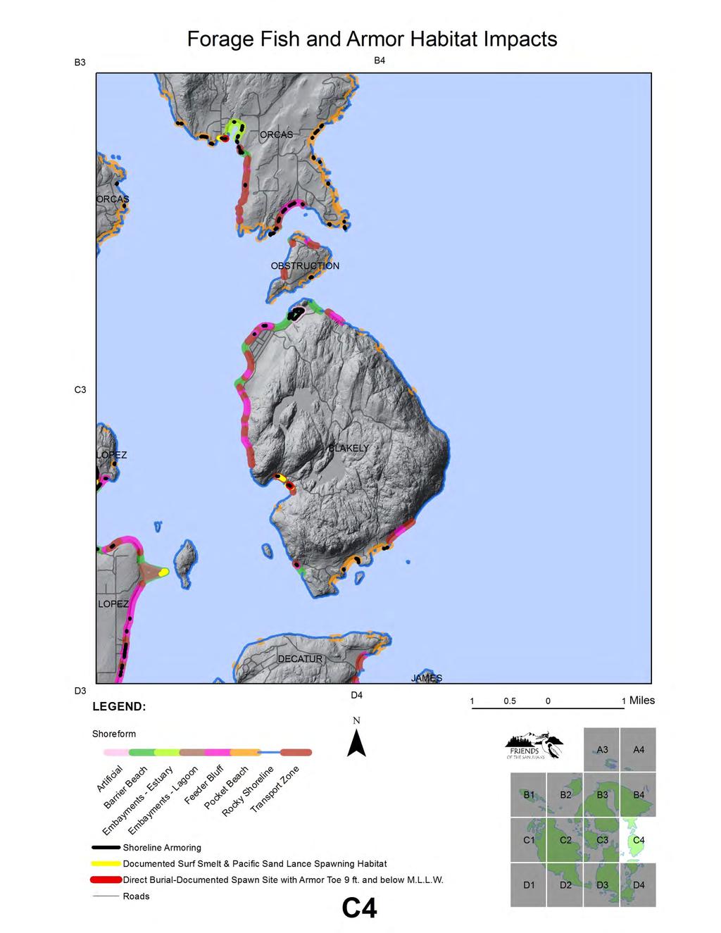
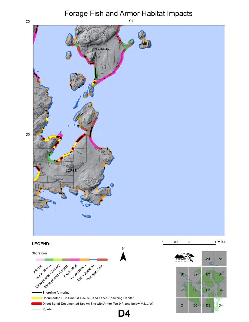
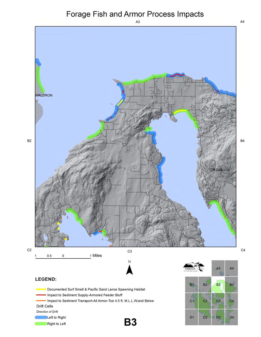
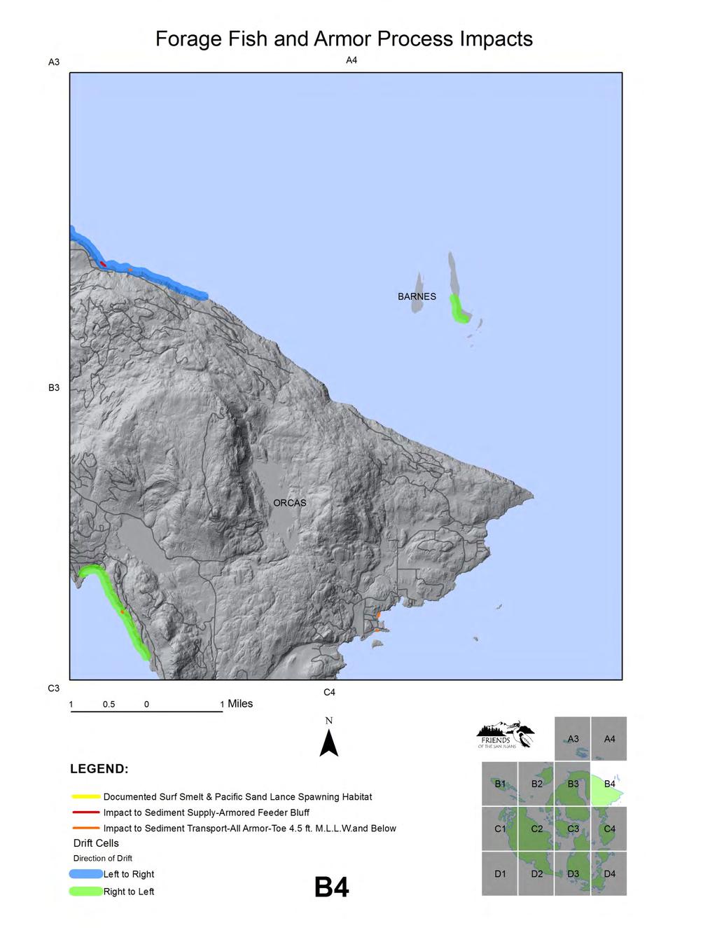
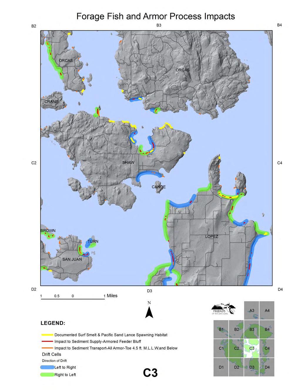
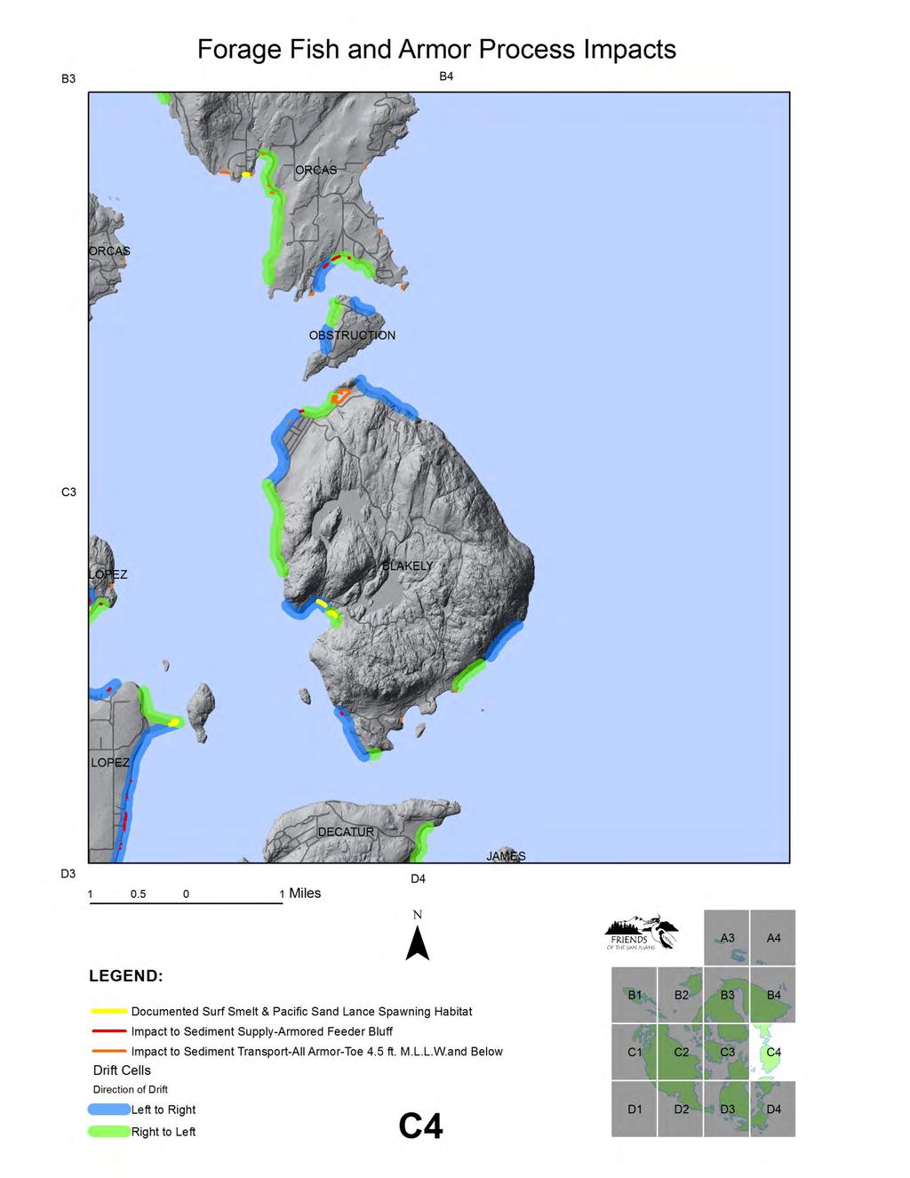
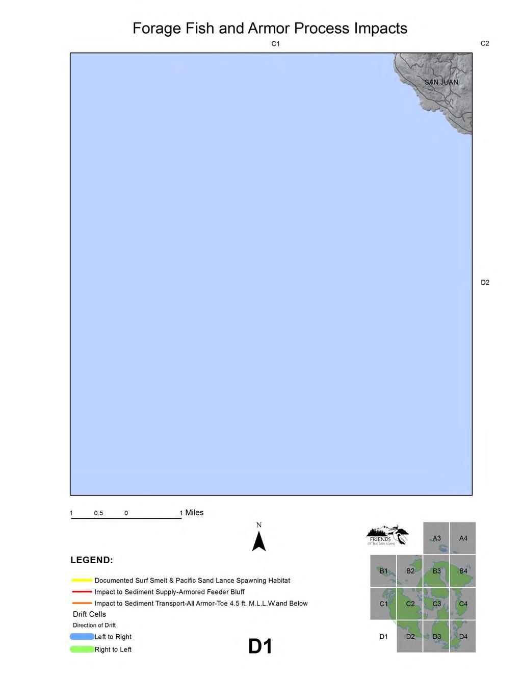
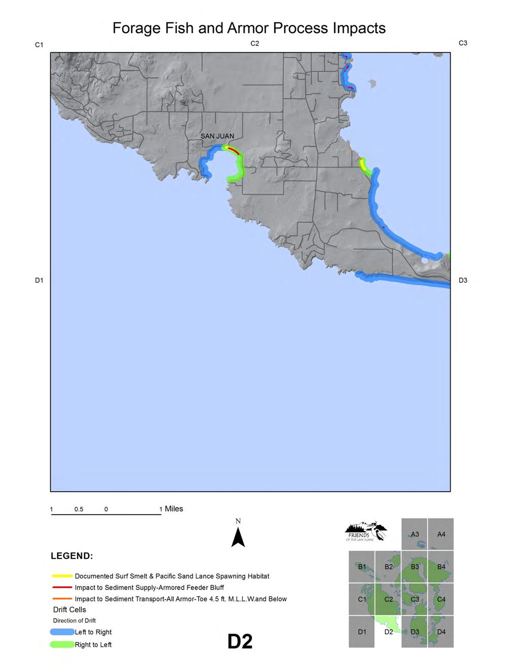
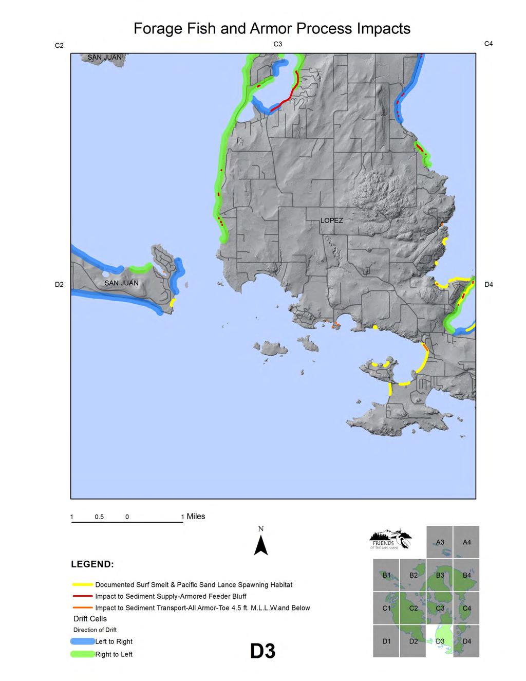
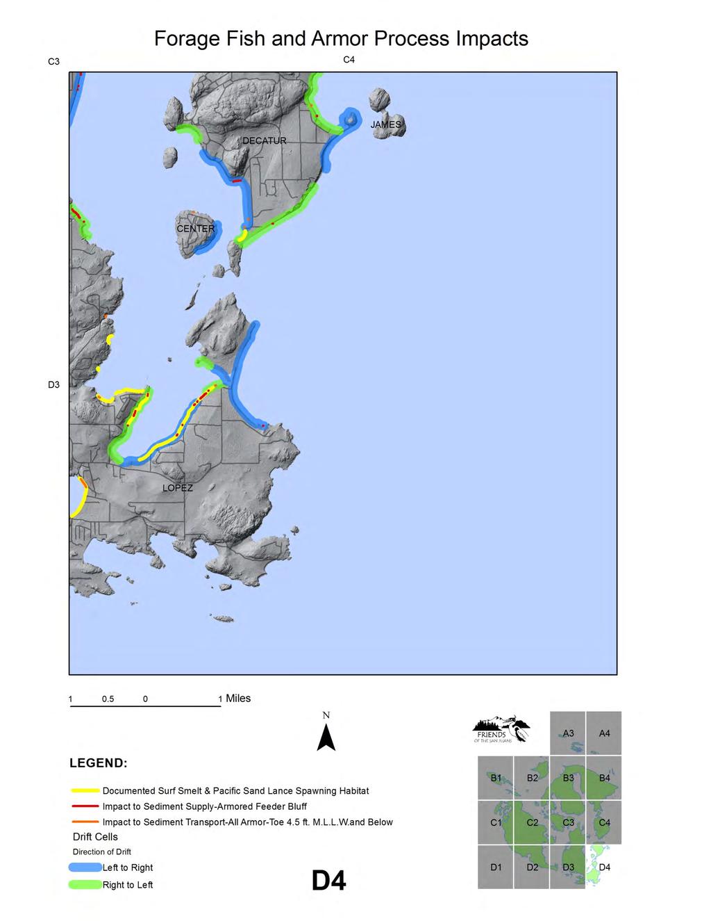
5 Results Just over eleven miles of surf smelt and/or Pacific sand lance spawning beaches have been documented in San Juan County. Sporadic spawning habitat assessment surveys were conducted by the Washington Department of Fish and Wildlife beginning in the late 1980 s and a concentrated survey effort was completed by Friends of the San Juans, in partnership with WDFW, Friday Harbor Marine Labs and the San Juan County Marine Resources Committee from Potential spawning habitat was assessed through a combination of aerial photo interpretation and field based analysis of suitable spawning substrate. Over 80 miles of potential spawning habitat is documented in San Juan County. The majority of documented forage fish spawning in San Juan County occurs on pocket beaches, with 44 of 186 shoretypes with spawn and 3.10 miles. Barrier beaches have the next highest occurrence of documented spawn, by length with 2.33 miles at 20 sites. Feeder bluffs also have substantial documented forage fish spawning habitat, with 39 sites and 1.98 miles. Forage fish spawn has also been documented in transport zones, with 28 sites making up just over 1.6 lineal shoreline miles of spawn habitat. The remaining mile or so of habitat occurs along artificial shorelines (those places where the shore has been modified to the extent that the original shoreform classification is uncertain, or along areas incorrectly classified as rocky shorelines. The majority of armor impacts on documented spawn sites were located on feeder buffs, followed by pocket beaches, barrier beaches, transport zones and then rocky shores. With 2.23 miles of armoring in place at known surf smelt and Pacific sand lance spawning beaches, 20% of documented spawn sites are currently armored. See Forage Fish and Armor Habitat Impacts Mapbook, beginning on page 14 and Table 1. Forage fish spawning habitat and shoreline armoring by shoreform, below. 5
6 Table 1. Forage Fish Spawning Beaches and Armoring by Shoreform Shoreform Documented Forage Fish Spawn Beaches - Count Documented Forage Fish Spawn - Length feet (miles) Armored Documented Forage Fish Spawning Beaches - Count Armored Documented Forage Fish Spawn - Length feet (miles) Artificial ft. (.05 mi) 0 0 Embayment 0 n/a n/a n/a Feeder Bluff 39 10,477 ft. (1.98 mi) ft. Transport Zone 28 8,685 ft. (1.64 mi) ft. Barrier Beach 20 11,797 ft. (2.23 mi) 7 1,613 ft. Pocket Beach 44 16,0359 ft. (3.10 mi) 22 2,986 ft. Rocky Shoreline* 54 9,244 ft.* (1.75 mi*) ft. total 186 sites 58,384 feet (11.06 miles) 71 sites 8,621 feet (1.63 miles) *NOTE: While shoreform maps of San Juan County have improved greatly over the past year with the completion of geomorphic feeder bluff mapping and pocket beach mapping (Coastal Geologic Services 2010 and 2011) some rocky shore remains incorrectly classified. Spawn not actually present on rocky shores, but shore segments classified as rocky due to resolution issues or errors including: small, unmapped pocket beaches, complex features such as tombolos or areas with heavy forest cover that may have limited classification efforts. Direct Burial of Spawning Habitat Surf smelt and Pacific sand lance are obligate intertidal spawners, requiring suitable substrate on the upper elevation portion of beaches to successfully incubate and hatch their eggs. The preferred spawning range of the surf smelt is 7 to 9 feet M.L.L.W., roughly at and above mean higher high water in San Juan County. On low profile beach types such as mud flats, the presence of armoring in the tidal elevation range of spawn can result in significant and permanent loss of spawning substrate through direct burial. While the overall area of impact may be less when quantified numerically at a steeper beach face site, as the area of suitable spawn area is also typically narrower at these types of sites, the loss of suitable spawning habitat may be just as severe. For this study, direct burial of spawning habitat was quantified by the lineal shoreline length of armoring with a toe elevation of 9 feet M.L.L.W. or below at documented surf smelt and Pacific sand lance spawning sites. The vast majority of armoring at documented sites are currently causing direct burial impacts to spawning habitat. With 2.07 miles of armor along documented forage fish spawning 6
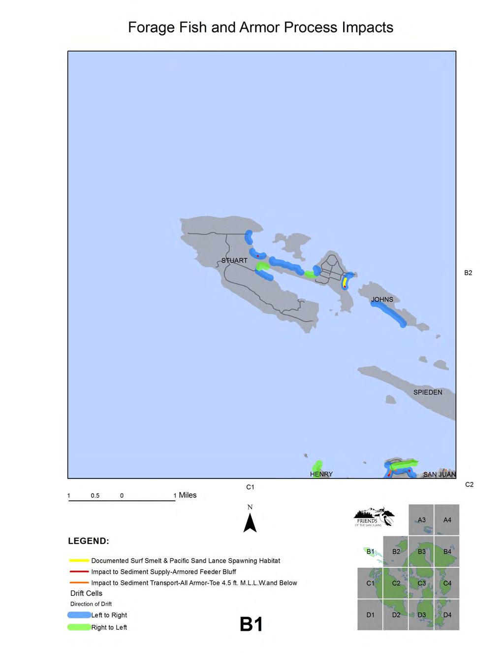
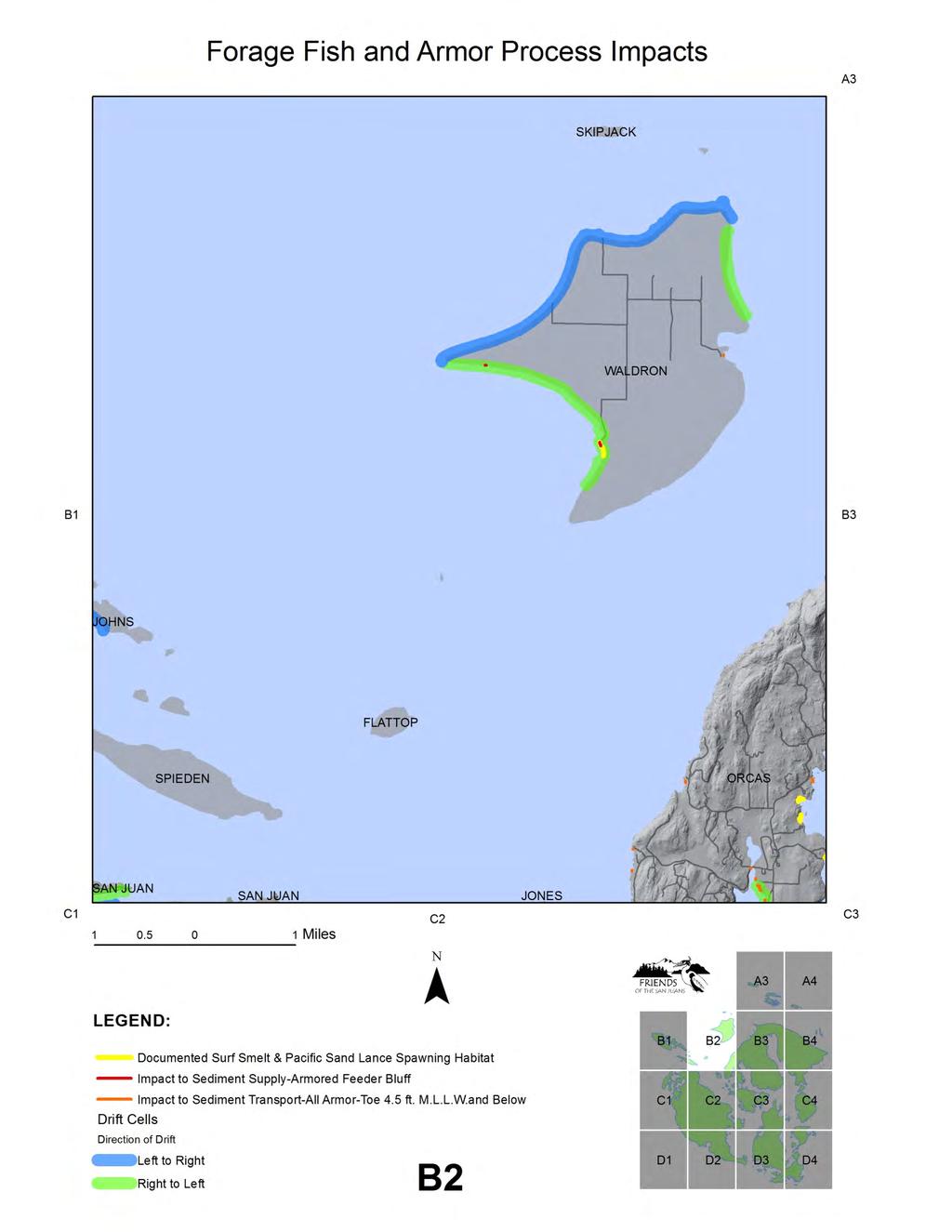
7 sites, 98% of these sites (1.60 miles) have a toe elevation at or below 9 feet M.L.L.W. See Forage Fish and Armor Habitat Impacts Mapbook, beginning on page 14 and Table 2. Direct burial of spawning habitat, below. Table 2. Direct Burial of Spawning Habitat (armored documented forage fish spawning beaches with armor toe elevation below 9 ft. M.L.L.W.) Shoreform Armored documented forage fish spawning beaches with armor toe elevation at or below 9 ft. M.L.L.W. - count Armored documented forage fish spawning beaches with armor toe elevation at or below 9 ft. M.L.L.W. - length Feet (miles) Artificial n/a n/a Embayment n/a n/a Feeder Bluff 30 3,073 ft. ( mi) Transport Zone ft. ( mi) Barrier Beach 7 1,613 ft. ( mi) Pocket Beach 20 2,817 ft. ( mi) Rocky Shoreline* ft. (mi) total 71 8,428 ft (miles) *See note about rocky shoreforms in Table 1, Impacts to Sediment Supply Erosion from bluffs provide over 90% of the beach sediment supply in Puget Sound and bluff sediment is an even larger percentage in San Juan County, which lacks major rivers to transport sediment from inland upland sources. Formation and maintenance of forage fish spawning beaches, with the required fine sediment size range to support beach spawning species such as surf smelt and Pacific sand lance, depends on long term protection and restoration of coastal sediment processes. Armoring of feeder bluffs, the primary sediment supply source, is a major concern for the long term maintenance of suitable spawning substrate. This is especially important in drift cells with documented forage fish spawn. Protection of sediment processes in all drift cells is a critical management imperative, to ensure protection of other substrate dependent functions and values such as shellfish and eelgrass. In addition, documentation of new spawning sites continues to occur in San Juan County and throughout the region. In San Juan County, there are 167 instances of armored feeder bluffs, or 4.94 miles where sediment supply has been impacted. Roughly one third of these armored feeder bluffs (1.3 miles) are located within drift cells with documented spawn. In San Juan County, there are 18 drift cells with armored feeder bluffs that also contain documented forage fish spawn habitat. 58 drift cells have armoring of feeder bluffs, disrupting sediment supply to potential forage fish 7
8 spawning habitat, or areas where spawn has not yet been documented. These areas are top restoration priorities to ensure adequate sediment supply to maintain forage fish spawning substrate at known spawning sites into the future. Protection of intact feeder bluffs within drift cells with documented forage fish spawning habitat should also be a top management strategy. See Forage Fish and Armor Process Impact Map Book, beginning on page 29 and Table 3. Sediment Supply Impacts, below. Table 3. Sediment Supply Impacts to Forage Fish Spawn Habitat (armored feeder bluffs and armored feeder bluffs in drift cells with documented forage fish spawn) Drift cells Armored Feeder Bluffs - count Armored Feeder Bluffs - length Armored Feeder Bluffs in Drift Cells with Documented Forage Fish Spawning Beaches - Count Armored Feeder Bluffs in Drift Cells with Documented Forage Fish Spawning Beaches - Length ,076 feet 4.94 miles 58 6,813 feet 1.3 miles Impacts to Sediment Transport In addition to impacts to sediment supply, shoreline armoring can also disrupt sediment transport processes. Impacts to littoral drift were evaluated by identification of armoring with toe elevation at mean sea level and below. Mean sea level has been determined for multiple San Juan County sites by NOAA; the value of 4.5 feet M.L.L.W. (Friday Harbor NOAA station) was used in this countywide analysis. The severity of the impact to sediment transport processes also depends on shoreform, and location relative to documented or potential spawning habitat, with the largest impacts to sediment transport occurring when armoring with a toe elevation below mean sea level is located on feeder bluffs or transport zones updrift of documented forage fish spawning beaches. Nearly four miles of armoring with a toe elevation below mean sea level were documented in San Juan County, potentially impacting the transport of sediment to documented and potential forage fish spawning beaches. See Forage Fish and Armor Process Impact Map Book, beginning on page 29 and Table 4. Impacts to Sediment Transport, below. 8
9 Table 4. Impacts to Sediment Transport (armor with a toe elevation below mean sea level defined as 4.5 M.L.W.) Shoreform Armor located below mean sea level - count Armor located below mean sea level length Feet (miles) Artificial 4 2,937 ft. (.55 mi) Embayment-Estuary 13 1,041 ft. (.20 mi) Embayment-Lagoon 1 25 ft. (.004 mi) Barrier Beach 8 1,120 ft. (.21 mi) Pocket Beach 65 6,396 ft. (1.21 mi) Rocky Shoreline 72 4,039 ft. (.76 mi) Transport Zone 18 2,129 ft. (.40 mi) Feeder Bluff 28 2,544 ft. (.48 mi) total 209 sites 20,231 feet (3.83 miles) Marine Riparian Conditions Shoreline vegetation provides habitat structure and function for salmon and salmon prey. Research has shown that surf smelt egg survival is reduced up to 50% along armored shorelines (Rice 2006). The removal of shoreline, or riparian vegetation, is often associated with shoreline armoring. To help evaluate potential impacts to forage fish spawning success, and improve understanding of the relationship between armoring and shoreline vegetation, a visual assessment of overhanging vegetation at armored and unarmored documented forage fish spawning sites was conducted. Visual assessment was conducted using oblique and vertical aerial photographs from the Washington Department of Ecology as well as infrared vertical aerials (Friends of the San Juans and the WA Department of Natural Resources). Overhanging vegetation presence was classified into five categories (none,.1 to 25%, 26-50%, 51-75% and %). Changes to overhanging vegetation at armored documented spawn sites was most pronounced for feeder bluff, pocket beach and rocky shoreforms. See Table 5. Overhanging Marine Riparian Vegetation; results shown as for the dominant coverage classes only. 9
10 Table 5. Overhanging Marine Riparian Vegetation dominant coverage class (coverage classes: none;.1-25%; 26-50%; 51-75%; %) Shoreform Overhanging Vegetation Shoreform with Spawn* Overhanging Vegetation Unarmored Spawning Beaches* Overhanging Vegetation Armored Spawning Beaches* Artificial none none n/a Embayment n/a n/a n/a Feeder Bluff % %.1-25% Transport Zone % % % Barrier Beach none none none Pocket Beach % % None Rocky Shore % % none Note: table simplified to show dominant coverage class results only. Conclusions/Management Implications With over 700 armored beaches and a limited number of documented forage fish spawning beaches, improved efforts to understand and manage the cumulative effects of shoreline armoring to these critical spawning habitats and habitat forming processes are needed. Forage fish play a critical role in marine foods, with a small number of forage fish species providing the critical link between zooplankton and the predators, including seabirds, marine mammals and a multitude of fish species including Chinook salmon. Improved management, including both restoration and protection strategies, are needed to reduce the impacts of bulkheads and shoreline infrastructure such as roads on beach spawning habitat and the coastal processes that form and maintain suitable spawning substrate. Top restoration priorities include: restoration to remove armoring from documented forage fish spawning beaches to uncover and restore buried spawning substrate; removal of shoreline armoring from feeder bluffs in drift cells with documented forage fish spawning habitat to restore sediment supply; and removal of shoreline armoring located below mean sea level updrift of documented spawning sites to restore sediment transport. Additional restoration priorities include the removal of armoring from feeder bluffs and removal of all armoring with a toe elevation less than mean sea level in drift cells with potential forage fish spawning habitat. As restoration success is limited by feasibility and high cost, improved protection will play an essential role in ensuring that forage fish spawning habitat and habitat forming processes are maintained into the future. Improved protections are needed to clearly prohibit the construction of new bulkheads at documented forage fish spawning sites or at feeder bluffs in drift cells with document spawning sites. In addition, policies to promote the removal or relocation of existing armoring, perhaps through enhanced repair/replace regulations, are needed countywide. Demand for armoring is expected to increase and the documentation of additional spawning sites is also likely. As such, policies designed to minimize the need for 10
11 future armoring at all shoreforms and drift cells and for potential as well as documented spawn sites, such as wider building setbacks and protection of vegetative buffers between structures and the shoreline, will be needed. Protection of beach habitats into the future, for fish, wildlife and people, will not be possible through restoration actions alone. Improved protection policies will be required. 11
12 References Bargmann, G Forage Fish Management Plan. A plan for managing the forage fish resources of Washington. Washington Department of Fish and Wildlife. Olympia, WA. 66 p. Bruun, P., Sea-level rise as a cause of shore erosion. Journal Waterways and Harbors Division, 88, (1-3), 117. Bulleri, F. and M.G. Chapman The introduction of coastal infrastructure as a driver of change in marine environments. Journal of Applied Ecology 2010, 47, Cooper, N.J The use of managed retreat in coastal engineering. Proceedings of the Institution of Civil Engineers Engineering Sustainability 156 Issue ES2 p Cox J., and M Baker Jr, Shoreline Armoring Effect and Engineering Techniques for Shoreline Erosion Management In Project Puget Sound, Seeking Balance: Conflict, Resolution & Partnership conference proceedings, p Downing, J., The Coast of Puget Sound, Its Processes and Development. Washington Sea Grant Publication, University of Washington Press, Seattle, 126 pp. Fletcher, C.H., R.A. Mullane, B.M. Richmond, Beach loss along armored shoreline on Oahu, Hawaiian Islands, Journal of Coastal Research, vol. 13, no. 1, p Fresh, K.L Juvenile Pacific Salmon in Puget Sound. Puget Sound Nearshore Partnership Report No Published by Seattle District, U.S. Army Corps of Engineers, Seattle, Washington. Friends of the San Juans Forage Fish Spawning Habitat Assessment and a Summary of Protection and Restoration Priorities for San Juan County Washington. Final Project Report. Friday Harbor, WA. Griggs, G.B., The impacts of coastal armoring. Shore and Beach, vol. 73, no. 1, Winter, p Glick, P., J. Clough and B. Nunley Sea-level Rise and Coastal Habitats in the Pacific Northwest: An Analysis for Puget Sound, Southwestern Washington, and Northwestern Oregon. National Wildlife Federation. Hampton, Monty, Griggs, Gary, Edil, Tuncer, Guy, Donald, Kelly, Joseph, Komar, Paul, Mickleson, David, and Shipman, Hugh, Processes that Govern the Formation and Evolution of Coastal Cliffs: Formation, Evolution, and Stability of Coastal Cliffs Status and Trends, Hampton, Monty A. and Griggs, Gary B. (editors), USGS Professional Paper 1693, p Hosking, A. & R. McInnes, Preparing for the Impacts of climate change on the Central Southeast of England: A framework for future risk management. Journal of Coastal Research, Special issue 36, IPCC (Intergovernmental Panel on Climate Change), Climate change 2001: The scientific basis. Contribution of Working Group 1 to the Third Assessment Report of the Intergovernmental Panel on Climate Change. Houghton, J. T., Y. Ding, D. J. Griggs, M. Noguer, P. 12
13 J. can der Linden, X. Dai, K. Maskell, and C. A. Johnson (eds). Cambridge University Press, Cambridge, United Kingdom and New York, NY, USA. 881 p. Johannessen, J.W. and A.J. MacLennan, Soft Shore Protection/Structure Removal Blueprint for San Juan County Forage Fish Beaches. Prepared for Friends of the San Juans, 40 p. Johannessen, J. and A. MacLennan Beaches and Bluffs of Puget Sound. Puget Sound Nearshore Partnership Report No Published by Seattle District, U.S. Army Corps of Engineers, Seattle, Washington. Legget, D.J., N. Cooper and R. Harvey Coastal and estuarine managed realignment- design issues. CIRIA. London Leschine, T.M. and A.W. Petersen Valuing Puget Sound s Valued Ecosystem Components. Puget Sound Nearshore Partnership Report No Published by Seattle District, U.S. Army Corps of Engineers, Seattle, Washington. MacDonald, K. D. Simpson, B. Paulsen, J. Cox, and J. Gendron, Shoreline Armoring Effects on Physical Coastal Processes in Puget Sound, Washington. Coastal Erosion Management Studies Volume 5. Shorelands and Water Resources Program, Washington Department of Ecology, Olympia. Report # MacLennan, A.J., J. W. Johannessen, San Juan Initiative Protection Assessment Nearshore Case Study Area Characterization, Final Report Prepared for The San Juan Initiative; The Puget Sound Partnership through The Surfrider Foundation, 54 p. plus appendices. Moulton, L. L. and D. E. Penttila, Field manual for sampling forage fish spawn in intertidal shore regions and the Distribution of potential surf smelt and Pacific sand lance spawning habitat in San Juan County. MJM Research and Washington Department of Fish and Wildlife for the San Juan County Forage Fish Project. Penttila, D.E Documented spawning areas of the Pacific herring (Clupea), surf smelt (Hypomesus), and Pacific sand lance (Ammodytes) in San Juan County, Washington. Washington Dept. of Fish and Wildlife, Marine Resources Division. Manuscript Report. LaConner, WA. 27p. Penttila, D Marine Forage Fishes in Puget Sound. Puget Sound Nearshore Partnership Report No Published by Seattle District, U.S. Army Corps of Engineers, Seattle, Washington. Pethick, J., Coastal management and sea-level rise. Catena, 42, Plant, N.G. and Griggs, G. B Interactions between nearshore processes and beach morphology near a seawall. Journal of Coastal Research, No. 8: Puget Sound Partnshership Action Agenda for Puget Sound. Redman, Scott, and Fresh, Kurt, Regional Nearshore and Marine Aspects of Salmon Recovery, Puget Sound Action Team and NOAA Fisheries Olympia/Seattle. 13
14 Rice, C Effects of Shoreline Modification on a Northern Puget Sound Beach: Microclimate and Embryo Mortality in Surf Smelt (Hypomesus pretiosus). Estuaries and Coasts. Vol 29, No. 1. p San Juan County Marine Resources Committee Marine Stewardship Area Conservation Action Plan. San Juan County and The Nature Conservancy, Friday Harbor, Washington. San Juan Initiative San Juan Initiative Protection Assessment Nearshore Case Study Area Characterization. San Juan County and the Puget Sound Partnership. Shared Strategy Puget Sound Chinook salmon recovery plan. Seattle, Washington. Stone, G. W., J. P. Morgan, A. Sheremet & X. Zhang, Coastal land loss and wave-surge predictions during hurricanes in Coastal Louisiana: implications for the oil and gas industry. Baton Rouge: Coastal Studies Institute, Louisiana State University. 67pp Thom, R., Shreffler, D., and Macdonald, Keith, Shoreline armoring effects on coastal ecology and biological resources in Puget Sound, Washington: Coastal Erosion Management Studies. Whitman, T Analysis of Shoreline Permit Activity in San Juan County, Washington ( ). Friends of the San Juans. Friday Harbor, WA. 14
15
16
17
18
19
20
21
22
23
24
25
26
27
28
29
30
31
32
33
34
35
36

37
38
39
40
41
42
43
Shoreline Modification Inventory for San Juan County, Washington
 Shoreline Modification Inventory for San Juan County, Washington Mud/Hunter Bay Region, Lopez July 2010 Friends of the San Juans P.O. Box 1344 Friday Harbor, WA 98250 www.sanjuans.org Shoreline Modification
The Cumulative Impacts of Shoreline Armoring on Forage Fish Spawning Habitat in San Juan County, Washington
 Western Washington University Western CEDAR Salish Sea Ecosystem Conference 2014 Salish Sea Ecosystem Conference (Seattle, Wash.) May 1st, 1:30 PM - 3:00 PM The Cumulative Impacts of Shoreline Armoring
San Juan County Shoreline Modification Inventory Restoration Opportunities Report
 San Juan County Shoreline Modification Inventory Restoration Opportunities Report June 2011 www.sanjuans.org San Juan County Shoreline Modification Inventory Restoration Opportunities Report Coastal geomorphic
Puget Sound Shorelines. Waves and coastal processes. Puget Sound shorelines: Effects of beach armoring
 Puget Sound Shorelines Puget Sound shorelines: Effects of beach armoring Waves and coastal processes Factors affecting wave energy hitting the coast Processes transporting sediment along coastlines What
Thanks to: -Current and former Habitat staff -Fish Program Marine Fish Division & Region 6 Staff
 Thanks to: -Current and former Habitat staff -Fish Program Marine Fish Division & Region 6 Staff - Overview Intro to forage fish What they are and why are they important Nearshore Forage Fish Habitat surveys
Blakely Island, N Thatcher Bay. Restoration Recommendation: Rank Score (total score)
") Soft Shore Protection/Structure Removal Blueprint for San Juan County Forage Fish Beaches Appendix 2: Recommendations for sites scoring below the top ten, sorted by island (east to west) Blakely Island,
Soft Shore Protection/Structure Removal Blueprint for San Juan County Forage Fish Beaches Appendix 2: Recommendations for sites scoring below the top ten, sorted by island (east to west) Blakely Island,
Puget Sound Nearshore Ecosystem Restoration Project Restore America s Estuaries Conference 2012 Tampa, FL
 Restore America s Estuaries Conference 2012 Tampa, FL presented by: Theresa Mitchell, WA Dept. of Fish & Wildlife Nearshore General Investigation Change Analysis: Comparison of historical and current
Analysis of Shoreline Permit Activity in San Juan County, Washington
 Analysis of Shoreline Permit Activity in San Juan County, Washington 1972-2005 Aerial Photo of Fisherman s Bay, Lopez Island by Mark Gardner Tina Whitman Friends of the San Juans P.O. Box 1344 Friday Harbor,
11426 Moorage Way P.O. Box 368 LaConner, WA Phone: Fax:
 Skagit River System Cooperative 11426 Moorage Way P.O. Box 368 LaConner, WA 98257-368 Phone: 36-466-7228 Fax: 36-466-447 www.skagitcoop.org BULL TROUT USE OF SWINOMISH RESERVATION WATERS Eric Beamer, Rich
Beach profile surveys and morphological change, Otago Harbour entrance to Karitane May 2014 to June 2015
 Beach profile surveys and morphological change, Otago Harbour entrance to Karitane May 2014 to June 2015 Prepared for Port Otago Ltd Martin Single September 2015 Shore Processes and Management Ltd Contact
The Blue Heron Slough Conservation Bank
 1 The Blue Heron Slough Conservation Bank CONSERVATION BANKING July 19-23, 2010 CASE STUDY SERIES The Blue Heron Slough Conservation Bank (Washington) I. OVERVIEW & BACKGROUND: Location: Snohomish River
New Jersey Coastal Zone Overview. The New Jersey Beach Profile Network (NJBPN) 3 Dimensional Assessments. Quantifying Shoreline Migration
 3 Dimensional Assessments. Quantifying Shoreline Migration") New Jersey Coastal Zone Overview The New Jersey Beach Profile Network (NJBPN) Objectives Profile Locations Data Collection Analyzing NJBPN Data Examples 3 Dimensional Assessments Methodology Examples Quantifying
New Jersey Coastal Zone Overview The New Jersey Beach Profile Network (NJBPN) Objectives Profile Locations Data Collection Analyzing NJBPN Data Examples 3 Dimensional Assessments Methodology Examples Quantifying
ALTERNATIVES FOR COASTAL STORM DAMAGE MITIGATION
 ALTERNATIVES FOR COASTAL STORM DAMAGE MITIGATION Dave Basco Old Dominion University, Norfolk, Virginia, USA National Park Service Photo STRUCTURAL (changes to natural, physical system) hardening (seawalls,
Feasibility Study for Restoration of Titlow Lagoon Fish Passage. South Puget Sound Salmon Enhancement Group
 Feasibility Study for Restoration of Titlow Lagoon Fish Passage South Puget Sound Salmon Enhancement Group January 2010 Feasibility Study for Restoration of Titlow Lagoon Fish Passage Prepared for South
EVALUATING THE EFFECTS OF BIVALVE SHELLFISH AQUACULTURE AND ITS ECOLOGICAL ROLE IN THE ESTUARINE ENVIRONMENT IN THE UNITED STATES
 EVALUATING THE EFFECTS OF BIVALVE SHELLFISH AQUACULTURE AND ITS ECOLOGICAL ROLE IN THE ESTUARINE ENVIRONMENT IN THE UNITED STATES Brett Dumbauld USDA Agricultural Research Service, Hatfield Marine Science
USE OF SEGMENTED OFFSHORE BREAKWATERS FOR BEACH EROSION CONTROL
 .. CETN-III-22 4/84 PURPOSE: USE OF SEGMENTED OFFSHORE BREAKWATERS FOR BEACH EROSION CONTROL To provide information on the functional application of and general design considerations for using offshore
ALTERNATIVES FOR COASTAL STORM DAMAGE MITIGATION AND FUNCTIONAL DESIGN OF COASTAL STRUCTURES
 The University of the West Indies Organization of American States PROFESSIONAL DEVELOPMENT PROGRAMME: COASTAL INFRASTRUCTURE DESIGN, CONSTRUCTION AND MAINTENANCE A COURSE IN COASTAL DEFENSE SYSTEMS I CHAPTER
April 7, Prepared for: The Caribbean Disaster Emergency Response Agency Prepared by: CEAC Solutions Co. Ltd.
 April 7, 2006 Prepared for: The Caribbean Disaster Emergency Response Agency Prepared by: Introduction CEAC Solutions Co. Ltd was commissioned in May 2005 to prepare coastal beach erosion hazard maps for
living with the shoreline A Stewardship Guide for San Juan County Property Owners
 living with the shoreline A Stewardship Guide for San Juan County Property Owners living with the shoreline A Stewardship Guide for San Juan County Property Owners The San Juan Islands and the Northwest
Volume and Shoreline Changes along Pinellas County Beaches during Tropical Storm Debby
 Volume and Shoreline Changes along Pinellas County Beaches during Tropical Storm Debby Ping Wang and Tiffany M. Roberts Coastal Research Laboratory University of South Florida July 24, 2012 Introduction
KUKUTALI PRESERVE JUVENILE CHINOOK SALMON AND FORAGE FISH ASSESSMENT
 KUKUTALI PRESERVE JUVENILE CHINOOK SALMON AND FORAGE FISH ASSESSMENT Eric Beamer, Josh Demma, and Rich Henderson Skagit River System Cooperative LaConner, WA March 2014 Report prepared for: Swinomish Indian
Estuarine Shoreline Stabilization
 Estuarine Shoreline Stabilization Property Owner s Guide to Determining the Most Appropriate Stabilization Method Estuarine shorelines are dynamic features that experience continued erosion. Land is lost
DRAFT TECHNICAL MEMORANDUM
 DRAFT TECHNICAL MEMORANDUM From: File No.: 213.001 Re: Beaux Arts Village Shoreline - 2016 Introduction The Washington Academy of Beaux Arts (WABA) completed shoreline habitat restoration at three locations
CHAPTER 4 DESIRED OUTCOMES: VISION, GOALS, AND OBJECTIVES
 CHAPTER 4 DESIRED OUTCOMES: VISION, GOALS, AND OBJECTIVES Vision One of the first steps in developing this Plan was articulating a vision - a clear statement of what the Plan strives to achieve and what
Building Coastal Resiliency at Plymouth Long Beach
 Building Coastal Resiliency at Plymouth Long Beach Department of Marine and Environmental Affairs March 30, 2017 Introducing Green Infrastructure for Coastal Resiliency Plymouth Long Beach & Warren s Cove
Sea-Level Rise and Coastal Habitats in Southeastern Louisiana An Application of the SLAMM Model
 Sea-Level Rise and Coastal Habitats in Southeastern Louisiana An Application of the SLAMM Model Patty Glick (National Wildlife Federation) Jonathan Clough (Warren Pinnacle Consulting, Inc.) Amy Polaczyk
VIMS CCRM Coastal Management Decision Tools. Decision Tree for Undefended Shorelines and Those with Failed Structures
 VIMS CCRM Coastal Management Decision Tools Decision Tree for Undefended Shorelines and Those with Failed Structures Center for Coastal Resources Management Virginia Institute of Marine Science Gloucester
Friends of Semiahmoo Bay Society
 Friends of Semiahmoo Bay Society Marine Conservation Initiative Boundary Bay Intertidal Forage Fish Spawning Habitat Project Summary of the Project and Findings July 2006 October 2007 Funding Provided
Beach Profiles. Topics. Module 9b Beach Profiles and Crossshore Sediment Transport 3/23/2016. CE A676 Coastal Engineering
 Beach Profiles AND CROSS-SHORE TRANSPORT Orson P. Smith, PE, Ph.D., Professor Emeritus Topics Features of beach and nearshore profiles Equilibrium profiles Cross-shore transport References Text (Sorensen)
AN OVERVIEW OF RECENT PROJECTS RELATED TO SAND BUDGETS, SOUTHERN CALIFORNIA BEACHES
 AN OVERVIEW OF RECENT PROJECTS RELATED TO SAND BUDGETS, SAND SUPPLY, COASTAL ARMORING, MANAGEMENT, AND VALUING SOUTHERN CALIFORNIA BEACHES Dr. Kiki Patsch California State University Channel Islands Environmental
Nearshore Sediment Transport What influences the loss of sediment on Beaches? - Waves - Winds - Tidal Currents - River discharge - Runoff
 Tides & Beaches Nearshore Sediment Transport What influences the loss of sediment on Beaches? - Waves - Winds - Tidal Currents - River discharge - Runoff Oceans Ocean Topography Physical Structure of the
CHAPTER 8 ASSESSMENT OF COASTAL VULNERABILITY INDEX
 124 CHAPTER 8 ASSESSMENT OF COASTAL VULNERABILITY INDEX 8.1 INTRODUCTION In order to assess the vulnerability of the shoreline considered under this study against the changing environmental conditions,
Future Condi,ons coastal hazard modeling and mapping
 Future Condi,ons coastal hazard modeling and mapping Presented by Bob Ba:alio, PE Environmental Science Associates, Inc. (ESA) On behalf of the physical processes team (USGS, TerraCosta- Scripps, ESA)
DUNE STABILIZATION AND BEACH EROSION
 DUNE STABILIZATION AND BEACH EROSION CAPE HATTERAS NATIONAL SEASHORE NORTH CAROLINA ROBERT DOLAN PAUL GODFREY U. S. DEPARTMENT OF INTERIOR NATIONAL PARK SERVICE OFFICE OF NATURAL SCIENCE WASHINGTON, D.
COMMENTS ON SEATTLE DISTRICT 2017 NATIONWIDE PERMIT GENERAL REGIONAL CONDITIONS AND SPECIFIC REGIONAL CONDITIONS
 State of Washington DEPARTMENT OF FISH AND WILDLIFE Mailing Address: 600 Capitol Way N, Olympia, WA 98501-1091 (360) 902-2200 TDD (360) 902-2207 Main Office Location: Natural Resources Building, 1111 Washington
Inlet Management Study for Pass-A-Grille and Bunces Pass, Pinellas County, Florida
 Inlet Management Study for Pass-A-Grille and Bunces Pass, Pinellas County, Florida Final Report Submitted By Ping Wang, Ph.D., Jun Cheng Ph.D., Zachary Westfall, and Mathieu Vallee Coastal Research Laboratory
Figure79. Location map for the 10 NJBPN profile sites in Atlantic County, NJ 155
 154 Figure79. Location map for the 10 NJBPN profile sites in Atlantic County, NJ 155 ATLANTIC COUNTY SPRING 2009 to FALL 2010 The Atlantic County coastline consists of three barrier islands. Between Little
Inventory of coastal sandy areas protection of infrastructure and planned retreat
 2018-02-28 Inventory of coastal sandy areas protection of infrastructure and planned retreat Johanna Birgander, Thorbjörn Nilsson, Pär Persson Summary To estimate the natural protection around the coast
Inventory and Mapping of City of Seattle Shorelines along Lake Washington, the Ship Canal, and Shilshole Bay
 SAFS-UW-0302 April 2003 Inventory and Mapping of City of Seattle Shorelines along Lake Washington, the Ship Canal, and Shilshole Bay J TOFT, C SIMENSTAD, C YOUNG, L STAMATIOU Wetland Ecosystem Team University
CROSS-SHORE SEDIMENT PROCESSES
 The University of the West Indies Organization of American States PROFESSIONAL DEVELOPMENT PROGRAMME: COASTAL INFRASTRUCTURE DESIGN, CONSTRUCTION AND MAINTENANCE A COURSE IN COASTAL DEFENSE SYSTEMS I CHAPTER
Town of Duck, North Carolina
 Tracking No. 00.00.2010 Erosion Mitigation And Shoreline Management Feasibility Study Town of Duck, North Carolina Coastal Planning & Engineering of North Carolina August 15, 2012 Tom Jarrett Robert Neal
Louisiana CPRA SJB Group, Baton Rouge Coastal Engineering Consultants U.S. Army Corps of Engineers Federal and State PDT Members
 Louisiana CPRA SJB Group, Baton Rouge Coastal Engineering Consultants U.S. Army Corps of Engineers Federal and State PDT Members Project Setting and Background Island Restoration Plans Pre-Screening Analysis
Environmental Protection on the Gold Coast of Queensland, Australia. 1. What is the appeal of the Gold Coast to tourists?
 Environmental Protection on the Gold Coast of Queensland, Australia Sections 1. What is the appeal of the Gold Coast to tourists? 2. How are Gold Coast visitor trends changing? 3. How can the impacts of
FISHERIES BLUE MOUNTAINS ADAPTATION PARTNERSHIP
 FISHERIES A warming climate, by itself, substantially affects the hydrology of watersheds in the Blue Mountains. Among the key hydrologic changes projected under all scenarios for the 2040s and beyond
Time Will Tell: Long-term Observations of the Response of Rocky-Habitat Fishes to Marine Reserves in Puget Sound
 Time Will Tell: Long-term Observations of the Response of Rocky-Habitat Fishes to Marine Reserves in Puget Sound Wayne A. Palsson, Robert E. Pacunski, and Tony R. Parra Washington Department of Fish and
Reading Material. Inshore oceanography, Anikouchine and Sternberg The World Ocean, Prentice-Hall
 Reading Material Inshore oceanography, Anikouchine and Sternberg The World Ocean, Prentice-Hall BEACH PROCESSES AND COASTAL ENVIRONMENTS COASTAL FEATURES Cross section Map view Terminology for Coastal
Climate Change Impacts to KSC Launch Complex
 Climate Change Impacts to KSC Launch Complex Presented to: 2010 International Workshop on Environment and Energy By: John Shaffer NASA Environmental Management Branch Kennedy Space Center Hurricane Season
North Shore of Long Island, Feasibility Study
 North Shore of Long Island, Asharoken New York Asharoken, Feasibility Study Asharoken, NY Public Meeting June 30, 2015 US Army Corps of Engineers US Army Corps of Engineers New York BUILDING STRONG BUILDING
Proposed Terrestrial Critical Habitat for the Northwest Atlantic Loggerhead Sea Turtle Population. U.S. Fish and Wildlife Service
 Proposed Terrestrial Critical Habitat for the Northwest Atlantic Loggerhead Sea Turtle Population U.S. Fish and Wildlife Service History of Loggerhead Listing (joint responsibility USFWS and NOAA Fisheries)
GONE! Coastal Erosion Happens During Storms! Why Worry About Coastal Setbacks? Goals for Today
 RI Regulatory Setbacks & Buffers: Coastal Zone Management Issues New England Onsite Wastewater Training Program @ URI OWT 155 November 21, 2013 Goals for Today Understand the impacts of storms, coastal
Long Beach Island Holgate Spit Little Egg Inlet Historical Evolution Introduction Longshore Transport Map, Survey and Photo Historic Sequence
 Appendix B Long Beach Island Holgate Spit Little Egg Inlet Historical Evolution Introduction The undeveloped southern end of Long Beach Island (LBI) is referred to as the Holgate spit as it adjoins the
STATUS REPORT FOR THE SUBMERGED REEF BALL TM ARTIFICIAL REEF SUBMERGED BREAKWATER BEACH STABILIZATION PROJECT FOR THE GRAND CAYMAN MARRIOTT HOTEL
 August 23 STATUS REPORT FOR THE SUBMERGED REEF BALL TM ARTIFICIAL REEF SUBMERGED BREAKWATER BEACH STABILIZATION PROJECT FOR THE GRAND CAYMAN MARRIOTT HOTEL performed by Lee E. Harris, Ph.D., P.E. Consulting
INTRODUCTION TO COASTAL ENGINEERING
 The University of the West Indies Organization of American States PROFESSIONAL DEVELOPMENT PROGRAMME: COASTAL INFRASTRUCTURE DESIGN, CONSTRUCTION AND MAINTENANCE A COURSE IN COASTAL DEFENSE SYSTEMS I CHAPTER
RI Regulatory Setbacks & Buffers: Coastal Management Issues
 RI Regulatory Setbacks & Buffers: Coastal Management Issues New England Onsite Wastewater Training Program @ URI OWT 155 - November 29, 2012 James Boyd - Coastal Policy Analyst Photo: October 30, 2012
FISH PASSAGE IMPROVEMENT in California s Watersheds. Assessments & Recommendations by the Fish Passage Forum
 FISH PASSAGE IMPROVEMENT in California s Watersheds Assessments & Recommendations by the Fish Passage Forum FISH PASSAGE IMPROVEMENT in California s Watersheds The mission of the Fish Passage Forum is
Cook Inlet Habitat Conservation Strategy
 Cook Inlet Habitat Conservation Strategy What is the Cook Inlet Habitat Conservation Strategy? It s a new effort to tie together all of NOAA Fisheries habitat-related science and management activities
RE: Hurricane Matthew Beach Damage Assessment and Recommendations [CSE 2416]
![RE: Hurricane Matthew Beach Damage Assessment and Recommendations [CSE 2416]](/thumbs/83/87675702.jpg "RE: Hurricane Matthew Beach Damage Assessment and Recommendations [CSE 2416]") October 25, 2016 Iris Hill Town Administrator Town of Edisto Beach 2414 Murray St Edisto Beach SC 29438 RE: Hurricane Matthew Beach Damage Assessment and Recommendations [CSE 2416] Dear Iris, Hurricane
October 25, 2016 Iris Hill Town Administrator Town of Edisto Beach 2414 Murray St Edisto Beach SC 29438 RE: Hurricane Matthew Beach Damage Assessment and Recommendations [CSE 2416] Dear Iris, Hurricane
Klickitat County Shoreline Master Program Update. Open House March 15, 2017
 Klickitat County Shoreline Master Program Update Open House March 15, 2017 Agenda 6:00 6:10 Welcome 6:10 6:40 Presentation SMP Update Process Shoreline Analysis review 6:40 8:00 Open House Topics SMP Process
ST. JOSEPH PENINSULA, GULF COUNTY, FLORIDA Beach Re-Nourishment and Environmental Enhancement Project RECOMMENDATIONS
 ST. JOSEPH PENINSULA, GULF COUNTY, FLORIDA Beach Re-Nourishment and Environmental Enhancement Project RECOMMENDATIONS January 23, 2018 543 Harbor Boulevard, Suite 204 Destin, Florida 32541 850.654.1555
Ocean and Plume Science Management Uncertainties, Questions and Potential Actions (Work Group draft 11/27/13)
") Ocean and Plume Science Management Uncertainties, Questions and Potential Actions (Work Group draft 11/27/13) (The work group thinks the following four questions should form a logic path, but that logic
Ocean and Plume Science Management Uncertainties, Questions and Potential Actions (Work Group draft 11/27/13) (The work group thinks the following four questions should form a logic path, but that logic
Sub-watershed Summaries
 Project Description The Salmon Drift Creek Watershed Council (SDCWC) has focused their efforts in the Salmon River estuary for the past few years. The multifaceted partnership effort is nearing completion
SACO RIVER AND CAMP ELLIS BEACH SACO, MAINE SECTION 111 SHORE DAMAGE MITIGATION PROJECT APPENDIX F ECONOMIC ASSESSMENT
 SACO RIVER AND CAMP ELLIS BEACH SACO, MAINE SECTION 111 SHORE DAMAGE MITIGATION PROJECT APPENDIX F ECONOMIC ASSESSMENT Department of the Army New England District, Corps of Engineers 696 Virginia Road
SOCIETAL GOALS TO DETERMINE ECOSYSTEM HEALTH: A FISHERIES CASE STUDY IN GALVESTON BAY SYSTEM, TEXAS
 SOCIETAL GOALS TO DETERMINE ECOSYSTEM HEALTH: A FISHERIES CASE STUDY IN GALVESTON BAY SYSTEM, TEXAS Anthony S. Pait, NOAA, National Centers for Coastal Ocean Science Thomas P. O Connor, David R. Whitall,
Fish Community. Fish Habitat, Streams and Rivers
 Clear, Ston(e)y and White Lake Plan Fish Community The lakes support a cool/warm water fishery including muskellunge, walleye, largemouth and smallmouth bass, yellow perch, pumpkinseed, rockbass, blue
Evaluating the Influence of Development on Mule Deer Migrations
 2013 Annual Report Evaluating the Influence of Development on Mule Deer Migrations Teal Wyckoff 1,2, Matt Kauffman 3, Hall Sawyer 4, Shannon Albeke 2 1 Wyoming Cooperative Fish and Wildlife Research Unit,
Eelgrass and Macroalgae Presence/Absence Preliminary Surveys BHP Proposed Grays Harbor Potash Export Facility A Task 400
 Memorandum 40600-HS-MEM-55036 Revision 0 Date: 26 July 2018 Subject: Eelgrass and Macroalgae Presence/Absence Preliminary Surveys BHP Proposed Grays Harbor Potash Export Facility A17.0202.00 Task 400 INTRODUCTION
OECS Regional Engineering Workshop September 29 October 3, 2014
 B E A C H E S. M A R I N A S. D E S I G N. C O N S T R U C T I O N. OECS Regional Engineering Workshop September 29 October 3, 2014 Coastal Erosion and Sea Defense: Introduction to Coastal/Marine Structures
Habitat Development: Habitat Boulders Lawson Pier Foreshore Enhancement
 Habitat Development: Habitat Boulders Improve the existing habitat by stabilising beach sediments. Increase biodiversity by creating new habitats and colonisation opportunities. Loose cobble is unstable;
Dauphin Island East End Beach and Barrier Island Restoration Project. Beau Buhring South Coast Engineers
 Dauphin Island East End Beach and Barrier Island Restoration Project Beau Buhring South Coast Engineers Funding Funded with qualified outer continental shelf oil and gas revenues by the Coastal Impact
EVALUATION OF BEACH EROSION UP-DRIFT OF TIDAL INLETS IN SOUTHWEST AND CENTRAL FLORIDA, USA. Mohamed A. Dabees 1 and Brett D.
 EVALUATION OF BEACH EROSION UP-DRIFT OF TIDAL INLETS IN SOUTHWEST AND CENTRAL FLORIDA, USA Mohamed A. Dabees 1 and Brett D. Moore 1 The paper discusses the analysis of up-drift beach erosion near selected
MCCAW REACH RESTORATION
 Final Report MCCAW REACH FISH RESTORATION PHASE B Jack McCaw Inland Empire Action Coalition http://www.wwccd.net/ Phone: 509-956-3777 Hours: 8:00-4:30 Walla Walla County Conservation District Snake River
Identifying Areas with Potential to Contain High Value Fish Habitat (HVFH) June 2007
 June 2007") Identifying Areas with Potential to Contain High Value Fish Habitat (HVFH) June 2007 1 High Value Fish Habitat INTENT: To apply added precautionary protection to those special areas deemed of high value
Identifying Areas with Potential to Contain High Value Fish Habitat (HVFH) June 2007 1 High Value Fish Habitat INTENT: To apply added precautionary protection to those special areas deemed of high value
Chagrin River TMDL Appendices. Appendix F
 Appendix F The following are excerpts from the Eastern Brook Trout Joint Venture s Conservation Strategy (Working Draft v.6), Conserving the Eastern Brook Trout: Strategies for Action Found at: http://www.easternbrooktrout.org/constrategy.html
Mid-Columbia Fisheries Enhancement Group Annual Report Fiscal Year 06: July 1, 2005 June 30, 2006
 Mid-Columbia Fisheries Enhancement Group Annual Report Fiscal Year 06: July 1, 2005 June 30, 2006 Mission Statement The mission of the Mid-Columbia Fisheries Enhancement Group is to restore self-sustaining
LAB: WHERE S THE BEACH
 Name: LAB: WHERE S THE BEACH Introduction When you build a sandcastle on the beach, you don't expect it to last forever. You spread out your towel to sunbathe, but you know you can't stay in the same spot
Essential Fish Habitat OCNMS Advisory Council July 13, 2013
 Essential Fish Habitat OCNMS Advisory Council July 13, 2013 John Stadler Habitat Conservation Division NMFS Northwest Region Essential Fish Habitat (EFH) What is it, where did it come from, and what does
Australian Coastal Councils Conference
 Australian Coastal Councils Conference Kiama March 2019 Where Has My Beach Gone? (and what can I do about it?) Dr Andrew McCowan Water Technology Where Has My Beach Gone? Where Has My Beach Gone? Where
BEACH PROCESSES AND COASTAL ENVIRONMENTS
 BEACH PROCESSES AND COASTAL ENVIRONMENTS COASTAL FEATURES Cross section Map view TOPICS: Terminology Waves Beach Morphology Barriers Coastal Migration Tides Tidal Flats and Marshes Sediment Budgets Human
County of Santa Barbara Permit Option Analysis Goleta Beach JULY 13, 2017
 County of Santa Barbara Permit Option Analysis Goleta Beach JULY 13, 2017 Introduction 2 Goleta Beach Park welcomes 1.5 million visitors annually Amenities include: Picnic Areas and Group Areas w/bbqs
Bay County, MI Coastal Hazard Analysis Flood Risk Review Meeting. May 14, 2018
 Bay County, MI Coastal Hazard Analysis Flood Risk Review Meeting May 14, 2018 Agenda Introductions Coastal Flood Risk Study and Mapping Program Current Status Technical Overview of Study and Mapping Floodplain
NORTHERN CELL OPTIONS SHORTLIST RECOMMENDATIONS
 OPTIONS SHORTLIST RECOMMENDATIONS Coastal Unit C: Bayview Options recommended for MCDA scoring. Status quo. Planting 3. Renourishment (gravel) 6. Beach-scraping 7. Restore shingle crest. Inundation accommodation
Keywords: marine habitat recovery, derelict fishing gear
 Marine habitat recovery after derelict fishing net removal. Jeff June*, Kyle Antonelis, Natural Resources Consultants, Inc. Seattle, WA. *Corresponding author: jjune@nrccorp.com Keywords: marine habitat
WHAT ARE ECOSYSTEMS? Dr. V. N. Nayak Professor of Marine Biology (Retd)
") WHAT ARE ECOSYSTEMS? Dr. V. N. Nayak Professor of Marine Biology (Retd) An ECOSYSTEM is an interacting system of plant, animals, and humans and the surrounding environment. An ecosystem contains living
WHAT ARE ECOSYSTEMS? Dr. V. N. Nayak Professor of Marine Biology (Retd) An ECOSYSTEM is an interacting system of plant, animals, and humans and the surrounding environment. An ecosystem contains living
Chapter 4 EM THE COASTAL ENGINEERING MANUAL (Part I) 1 August 2008 (Change 2) Table of Contents. Page. I-4-1. Background...
 1 August 2008 (Change 2) Table of Contents. Page. I-4-1. Background...") Chapter 4 EM 1110-2-1100 THE COASTAL ENGINEERING MANUAL (Part I) 1 August 2008 (Change 2) Table of Contents I-4-1. Background... Page I-4-1 a. Shore Protection Planning and Design, TR 4... I-4-1 b. Shore
Chapter 4 EM 1110-2-1100 THE COASTAL ENGINEERING MANUAL (Part I) 1 August 2008 (Change 2) Table of Contents I-4-1. Background... Page I-4-1 a. Shore Protection Planning and Design, TR 4... I-4-1 b. Shore
COASTAL ENVIRONMENTS. 454 lecture 12
 COASTAL ENVIRONMENTS Repeated movement of sediment & water constructs a beach profile reflecting the balance between average daily or seasonal wave forces and resistance of landmass to wave action Coasts
Lake Tahoe Shoreline Plan. 05 Policy Topic: Piers- Fish Habitat, Design, and Scenic Issues
 Lake Tahoe Shoreline Plan 05 Policy Topic: Piers- Fish Habitat, Design, and Scenic Issues 07.20.2016 1 Brief Description There are 768 piers located along the shoreline of Lake Tahoe. Approximately 43
TITLE: North Carolina s Changing Shorelines. KEYWORDS: erosion - shorelines - mapping - sustainability
 UNC Coastal Studies Institute Teacher Resources 1 TITLE: North Carolina s Changing Shorelines KEYWORDS: erosion - shorelines - mapping - sustainability Changing shorelines impact coastal infrastructure.
Beach Nourishment Impact on Beach Safety and Surfing in the North Reach of Brevard County, Florida
 Beach Nourishment Impact on Beach Safety and Surfing in the North Reach of Brevard County, Florida Prepared by John Hearin, Ph.D. Coastal Engineering Vice Chairman Cocoa Beach Chapter Port Canaveral Patrick
Daniel E. Penttila Salish Sea Biological, Anacortes, WA
 A Review of Effects on Forage Fishes, Zooplankton and Marine Vegetation from Three Geoduck/Clam Farm Proposals in Henderson Inlet and One Proposal in Eld Inlet, Thurston County, WA Daniel E. Penttila Salish
PUBLIC EXHIBITION OF COASTAL ZONE MANAGEMENT PLAN FOR COLLAROY-NARRABEEN BEACH AND FISHERMANS BEACH
 ITEM 8.3 REPORTING MANAGER TRIM FILE REF 2014/110936 ATTACHMENTS PUBLIC EXHIBITION OF COASTAL ZONE MANAGEMENT PLAN FOR COLLAROY-NARRABEEN BEACH AND FISHERMANS BEACH GROUP MANAGER NATURAL ENVIRONMENT 1
An Update of Coastal Erosion in Puerto Rico
 Jack Morelock and Maritza Barreto An Update of Coastal Erosion in Puerto Rico Department of Marine Sciences, University of Puerto Rico at Mayagüez and Geography Department, University of Puerto Rico at
Wind Blow-out Hollow Generated in Fukiage Dune Field, Kagoshima Prefecture, Japan
 R. Nishi Wind Blow-out Hollow Generated in Fukiage Dune Field, Kagoshima Prefecture, Japan Ryuichiro Nishi, Li Elikson and Myokhin PREFACE A sand dune is vulnerable to severe waves and wind. Therefore,
Essential Fish Habitat
 Pacific Fishery Management Council Fact sheet: Essential Fish Habitat Habitat is the environment where an animal lives, feeds, and reproduces. Identifying fish habitat is complex because fish move through
Admiralty Inlet Pilot Tidal Project FERC No Appendix C. Derelict Gear Monitoring Plan
 Appendix C Derelict Gear Monitoring Plan ADMIRALTY INLET PILOT TIDAL PROJECT FERC PROJECT NO. 12690 DERELICT GEAR MONITORING PLAN (submitted with the Final Application for a New Pilot Project License)
Essential Fish Habitat Consultation
 1 Essential Fish Habitat Consultation Marine Shoreline Development Workshop February 21, 2007 John H. Stadler Washington State Habitat Office National Marine Fisheries Service Magnuson-Stevens Fishery
HARBOUR SEDIMENTATION - COMPARISON WITH MODEL
 HARBOUR SEDIMENTATION - COMPARISON WITH MODEL ABSTRACT A mobile-bed model study of Pointe Sapin Harbour, in the Gulf of St. Lawrence, resulted in construction of a detached breakwater and sand trap to
Chronic coastal erosion is a statewide problem
 Chronic coastal erosion is a statewide problem 1 Seawalls are constructed where there is erosion, but they do not solve the erosion they often worsen it along adjacent shores. Hawaii needs erosion solutions.
Project Webpage:
 Project Webpage: http://nature.ly/marinesatlanticbightera Coastal Data and Full Metadata: http://easterndivision.s3.amazonaws.com/marine/sab MA/SABMACoastalEcosystems.zip Coastal Chapter: http://easterndivision.s3.amazonaws.com/marine/sab
ATLANTIC COUNTY 2006 to 2008
 ATLANTIC COUNTY 2006 to 2008 The Atlantic County oceanfront shoreline consists of three barrier islands where the northern one, Little Beach Island and a third of the second, Brigantine Island, are undeveloped
APPENDIX AIR10-C. Technical Data Reports Containing Habitat Maps at Local and Regional Scales. TDR MF-4 - Forage Fish Beach Spawn Survey TDR
 APPENDIX AIR10-C Technical Data Reports Containing Habitat Maps at Local and Regional Scales TDR MF-4 - Forage Fish Beach Spawn Survey TDR PORT METRO VANCOUVER Roberts Bank Terminal 2 Information Request