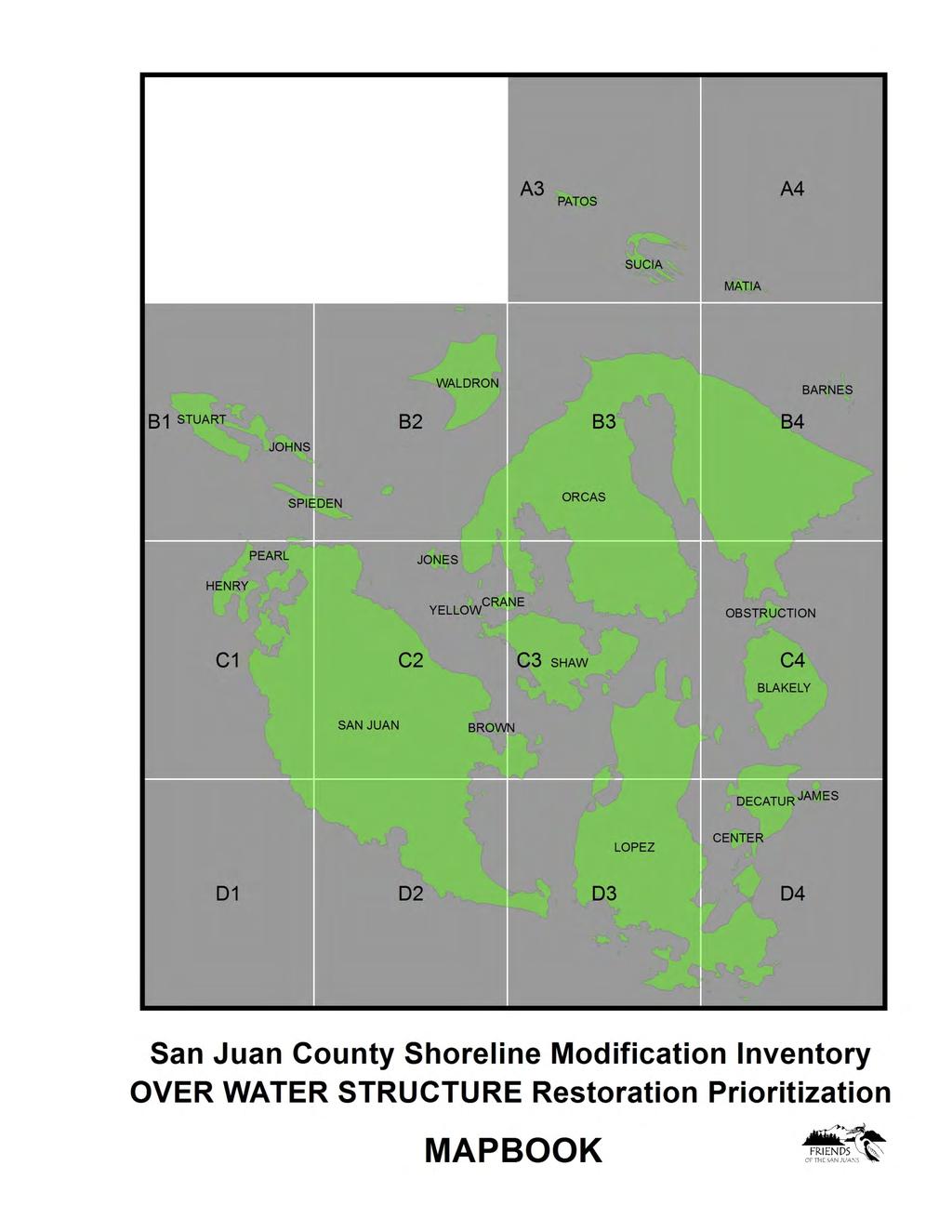
San Juan County Shoreline Modification Inventory Restoration Opportunities Report
|
|
|
- Hannah Dawson
- 6 years ago
- Views:
Transcription


1 San Juan County Shoreline Modification Inventory Restoration Opportunities Report June
2 San Juan County Shoreline Modification Inventory Restoration Opportunities Report Coastal geomorphic processes create and maintain the nearshore habitats upon which many Puget Sound species of concern rely, including forage fish spawning areas, and juvenile salmonid rearing and migratory habitats, among others (Fresh 2006, Penttila 2007, Johannessen and MacLennan 2007). A recent study by C. Rice (2006) documented the effects of shoreline modifications on Puget Sound beaches on surf smelt mortality. Results showed that anthropogenic alteration of the shoreline typically makes beaches less suitable for surf smelt embryo survival when compared with unmodified shores (Rice 2006). Loss of marine riparian areas is commonly associated with shoreline development and modified shores. Shore modifications, almost without exception, impact the ecological functioning of nearshore coastal systems and the proliferation of these structures has been viewed as one of the greatest threats (Thom et al. 1994). Modifications often result in the loss of the very feature that attracted coastal property owners in the first place, the beach (Fletcher et al. 1997). Bulkheads and other shore modifications that bury habitat, and limit bluff erosion and littoral sediment transport have led to major changes in sediment supply and associated changes in beach and habitat stability. The cumulative impact of human modifications to the shoreline may be far-reaching in terms of both habitat and existing human activities, particularly in the face of anticipated increases in the rate of sea level rise and storm induced erosion. With over 400 miles of shoreline located at the confluence of Puget Sound, Georgia Strait and the Strait of Juan de Fuca, the nearshore marine habitats of San Juan County (SJC) play a critical role in the regional ecosystem. The same forage fish species and nearshore habitats of interest in salmon recovery are also vital to the protection and restoration of additional key marine species including six stocks of Puget Sound rockfish; multiple species of seabirds, including the federally threatened Marbled murrelet; and the federally threatened Southern Resident Killer Whale. Shoreline modification is identified as a top threat to the SJC marine ecosystem (SJC Marine Stewardship Area Plan 2007). In 2009, FSJ conducted a boat-based inventory and mapping project of shoreline modifications for all 400+ miles of marine shoreline within San Juan County. Just under 4,000 modifications were mapped, photographed and described. Modifications in San Juan County include: 710 armored beaches, 472 docks, 32 groins, 55 marine railways, 70 improved boat ramps, 116 piling groupings (425 pilings), 50 marina/jetty/breakwater, and 191 other on-beach structures (FSJ 2010). Information on structure size, material, tidal elevation and collection were recorded where relevant to inform understanding of potential habitat impacts and support the identification and prioritization of restoration opportunities. For more information on the Shoreline Modification Inventory for San Juan County methods and results, please see the project s Executive Summary and Readme reports. 1

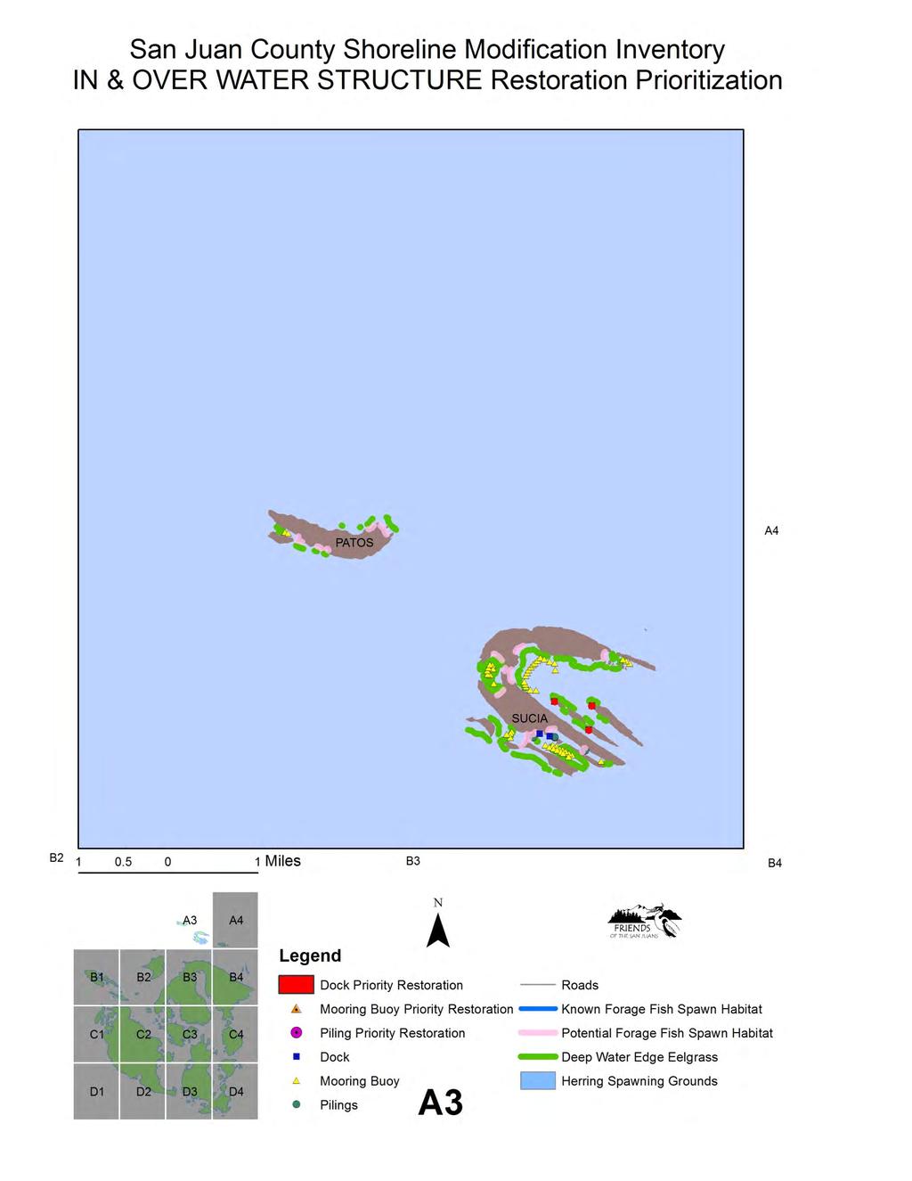
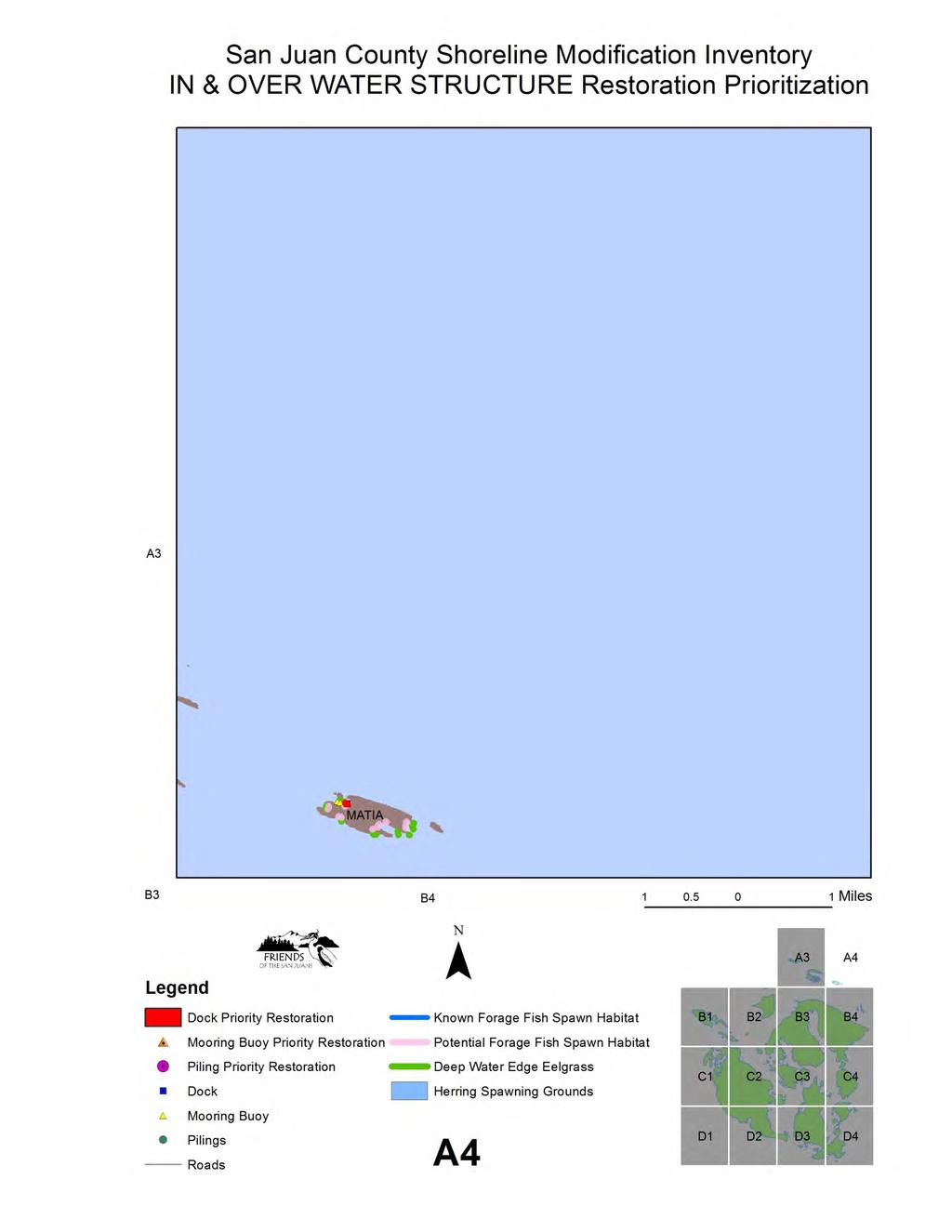
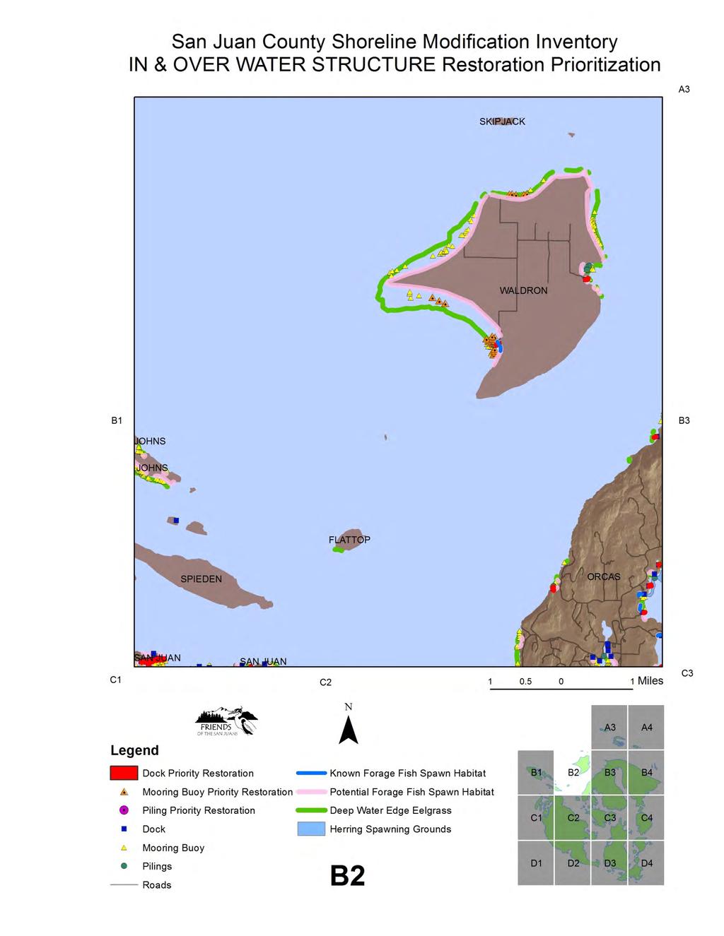
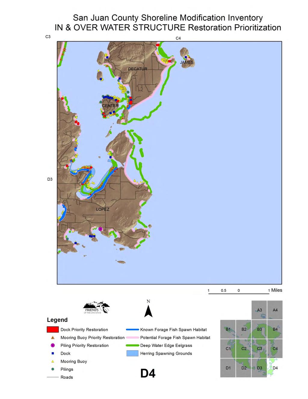
3 Restoration Project Identification and Prioritization In 2010, results of the 2009 shoreline modification inventory were applied to a countywide identification and prioritization of potential restoration opportunities. Restoration opportunities were identified and prioritized using a combination of data sets on priority habitats and species, geomorphic shoretype, and details of the modification itself, such as size, tidal elevation, material and condition. Opportunities to reduce the impacts of existing structures through design and material changes, for those structures unlikely to be removed, such as docks, were also noted. Targeted outreach efforts were conducted for sites identified in the restoration prioritization. Informational mailings targeted two types of habitat improvement opportunities: 1) identifying landowners interested in restoration through modification removal at top ranked sites, and 2) reaching owners of degraded or poor condition docks and bulkheads, highlighting specific actions they can take to reduce habitat impacts if they are considering repair or replacement activities. Outreach materials included information on priority nearshore marine species and habitats, the impacts of modifications, by type such as dock, buoy or bulkhead, as well as ways to reduce impacts, through removal or redesign of existing structures. Friends of the San Juans has secured grant funds to continue project cultivation work with interested landowners of top priority restoration project sites into the future, including completing expert site visits, restoration feasibility analyses and preliminary designs. Targeted mailings offered these free services to interested landowners at highly ranked sites. Mooring buoys results have been applied to a related buoy upgrade cost share program being piloted by Friends of the San Juans, through which multiple outdated buoy designs were removed from eelgrass habitat in the summer of Additional eelgrass restoration through buoy redesign or relocation work planned for Criteria used in the identification and ranking of restoration opportunities from the 2009 inventory of shoreline modifications and restoration ranking results are described below and shown in the associated map books. The report and map books are organized into two categories: over and in water structures (buoys, pilings and docks), followed by on-beach structures (improved boat ramps, groins and armoring). 2
4 Restoration Opportunities- Over and In Water Structures The potential removal of over and in water structures covered in the shoreline modification inventory restoration prioritization included buoys, pilings and docks. Marinas and large community docks were not ranked for restoration potential as the opportunity for removal is considered unlikely, or low. Restoration opportunity for buoys, pilings and docks was conducted for all structures within those project types, and rankings were based on proximity to priority habitats and species including eelgrass, known Pacific herring spawning grounds, and documented presence of out-migrating juvenile salmon. Results were binned into Top, High and Moderate restoration opportunity categories. See Figure 1. Over and In Water Structures Restoration Prioritization map book. BUOYS A total of 1,914 mooring buoys and floats were recorded in the 2009 field inventory, including 1,835 buoys and 79 floats (not associated with a dock or marina). This is an average of 4.7 buoys per linear marine shoreline mile (FSJ 2010). Buoys are heavily concentrated within embayments and protected pocket beaches. Improperly sited or designed mooring buoys can negatively impact submerged aquatic vegetation including eelgrass and macro algae such as kelps, priority habitats for forage fish and out-migrating juvenile salmon. Impacts primary occur through the anchor to surface line contacting the bed at low tide events. Additional impacts include anchor drag, shading, and the introduction of pollution. One third of mapped mooring buoys were located in eelgrass, and 50% were located in close proximity. With an estimated one-third of the mooring buoys in Puget Sound, a significant restoration opportunity exists in San Juan County to improve habitat, especially for eelgrass. Potential habitat restoration opportunities from buoy upgrades (redesigns), removals or relocations were prioritized based on the proximity to priority habitats and species. No assessment was made of buoy use, condition or distribution (e.g. numbers of buoys in a specific bay or region ). Three hundred and thirty five buoys, 18% of buoys in San Juan County, were identified as priority habitat restoration opportunities. The top two buoys identified were located within eelgrass and in close proximity to known herring spawning grounds as well as documented out-migrating juvenile salmon presence. The high restoration category included 293 buoys, for proximity to eelgrass and either documented herring grounds or out-migrating juvenile salmon. The moderate priority category used the same factors as the high category, with larger proximity distances, and included 140 buoys. See Table One below for a countywide and island breakout. While the individual impact of any one mooring buoy may be relatively small, the combination of high numbers of buoys and the relatively simple and low cost solutions to buoy impacts (relocation away from priority habitats or upgrade to latest design), makes this restoration project type a top habitat improvement opportunity for San Juan County. 3
 and herring SJI 0 upgrade or spawning")
5 Table 1. Buoy Restoration Prioritization Restoration Priority Ranking Criteria Number of Buoys Top priority for Proximity to eelgrass SJC 2 removal, design (100 ft) and herring SJI 0 upgrade or spawning grounds (100 Shaw 0 relocation ft) and juvenile salmon Orcas 2 (0.5 miles ) Lopez 0 High priority for removal, design upgrade or relocation Moderate priority for removal, design upgrade or relocation Proximity to eelgrass (100 ft) and proximity to juvenile salmon (0.5 miles) or herring spawning grounds (100 ft) Proximity to eelgrass (200 ft) and herring spawning grounds (200 ft) or juvenile salmon (0.5 miles) Outer Islands 0 SJC 293 SJI 56 Shaw 31 Orcas 68 Lopez 74 Outer Islands 64 SJC 140 SJI 35 Shaw 24 Orcas 24 Lopez 55 Outer Islands 2 4
. Piling material was overwhelmingly creosote (89%) (FSJ 2010).")
6 PILINGS One hundred and sixteen groupings of pilings not associated with another existing structure such as a dock or marina were documented along San Juan County s marine shorelines, including 425 individual pilings (FSJ 2010). Piling material was overwhelmingly creosote (89%) (FSJ 2010). The primary habitat impact from pilings is the leaching of toxins from the creosote wood material and its effect on water quality conditions for aquatic life. Studies on the effects of creosote wood contamination on spawning Pacific herring show that PAH contamination from 40 year old pilings in surface waters caused significant reductions in hatching success and increased abnormalities in surviving larvae (Vines et al 2000, Stratus 2005a). Impacts of PAH s in surface waters have also been studied for trout, with immune effects documented at the lowest observable concentrations (Karrow et al 1999, Stratus 2005a). Many studies have also investigated thresholds for biological effects of PAH concentrations in sediment. Effects on benthic fish included: liver lesions, spawning inhibition, infertile eggs and abnormal larvae (Stratus 2005a). While direct impacts to salmonids from PAH s in contaminated marine surface waters or sediments are believed to be relatively low, salmonids are potentially at risk of exposure from consumption of contaminated prey (Poston 2001). In addition, if emerging science shows that certain stocks of outmigrating juvenile salmon spend considerable time in shallower nearshore marine environments, direct impacts may occur in areas with high PAH s. Potential habitat restoration opportunities from piling removals were prioritized based on the proximity to priority habitats and species as well as piling material. A total of ten piling groupings were identified as high or moderate priorities for restoration through removal, for proximity to eelgrass and known Pacific herring spawning grounds or documented out-migrating juvenile salmon presence. As the majority of these pilings are not still in use or serving any purpose, removal of creosote pilings from priority habitats is likely a restoration opportunity with a high potential for broad landowner and community support. 5
7 Table 2. Pile Removal Prioritization Restoration Priority Ranking Criteria Number of Piling Groupings High priority Creosote piles and proximity SJC 9 to eelgrass (100 ft) and SJI 2 herring spawning grounds Shaw 2 (100 ft) or juvenile salmon Orcas 5 (0.5 mile) Lopez 0 Moderate priority Creosote piles and proximity to eelgrass (200 ft) and herring spawning grounds (200 ft) or juvenile salmon (0.5m) Outer Islands 0 SJC 10 SJI 2 Shaw 2 Orcas 5 Lopez 1 Outer Islands 0 DOCKS A total of 472 docks (excluding marinas and large community docks) were documented along San Juan County s marine shorelines (FSJ 2010). Of these, very few had incorporated best design practices for minimizing habitat impacts. Of the 472 docks recorded, 42 (8%) had grated floats and 17 (3%) had grated piers. 356 (77%) docks with creosote wood piles and/or decking were recorded. 39 (8%) docks were noted to be in poor condition (FSJ 2010). Over-water structures of any kind will result in loss of some habitat functions due to short-term (construction activities) and long-term (permanent structure features) impacts. Piers, docks, mooring floats and other types of overwater structures have the potential to alter the physical characteristics of nearshore environments both at the site and beyond the footprint of the structure. By altering the physical processes that operate in the nearshore environment, such as light penetration, wave energy, and sediment transport, overwater structures can promote changes in habitats. Once habitats are altered, the species using those habitats and the way those habitats are used may also change, affecting the biological community in a number of ways. For example, the shaded, deep-water environment under piers can create a favorable habitat for predatory fish. Juvenile salmon tend to migrate out around structures that shade the water column and into deeper water where they are exposed to increased predation. Overwater structures can also impair habitat function. For example, by shading the nearshore environment and altering wave energy and sediment transport characteristics, overwater structures can degrade eelgrass habitat, which is an important refuge for a variety of important marine species. Docks are often also associated with shoreline armoring- to secure the pier- which can directly bury intertidal habitat and interrupt natural coastal sediment processes as well as the removal of marine riparian vegetation. While full dock removal is unlikely to be a broadly applied restoration action for landowner willingness reasons, significant opportunities to at least reduce habitat impacts through design, size, orientation and material upgrades do provide some project potential. Investment in this area 6
8 should be focused on educating owners of existing docks about impact reduction, requiring improvements through repair/replace permit processes and working programmatically to reduce the ongoing proliferation of docks in the county. Potential habitat restoration opportunities from dock design upgrades or dock removals were prioritized based on the proximity to priority habitats and species including eelgrass, forage fish spawning habitat and out-migrating juvenile, salmon, as well as the current design, material and condition of the dock (pier, float and ramp) structure itself. A total of 259 docks were identified as high (51) or moderate ( 208) restoration opportunities. Table 3. Dock Removal Prioritization Restoration Priority Ranking Criteria Number of Docks High Priority- a Degraded condition dock and proximity to eelgrass (100 ft) and proximity to herring spawning grounds (100 ft) or proximity to juvenile salmon (0.5 mile) High Priority- b Moderate Priority-a Moderate Priority-b Moderate Priority-c Any condition dock and ungrated float and proximity to eelgrass (100 ft) and proximity to herring spawning grounds (100 ft) or proximity to juvenile salmon (0.5 mile) Degraded condition dock and proximity to eelgrass (200 ft) Creosote dock and proximity to herring spawn (200 ft) Any condition dock and un-grated float and proximity to eelgrass (200 ft) SJC 5 SJI 2 Shaw 1 Orcas 0 Lopez 2 Outer Islands 0 SJC 51 SJI 12 Shaw 10 Orcas 12 Lopez 5 Outer Islands 12 SJC 19 SJI 9 Shaw 3 Orcas 1 Lopez 3 Outer Islands 3 SJC 54 SJI 19 Shaw 3 Orcas 19 Lopez 11 Outer Islands 2 SJC 225 SJI 67 Shaw 18 Orcas 47 Lopez 17 Outer Islands 76 7

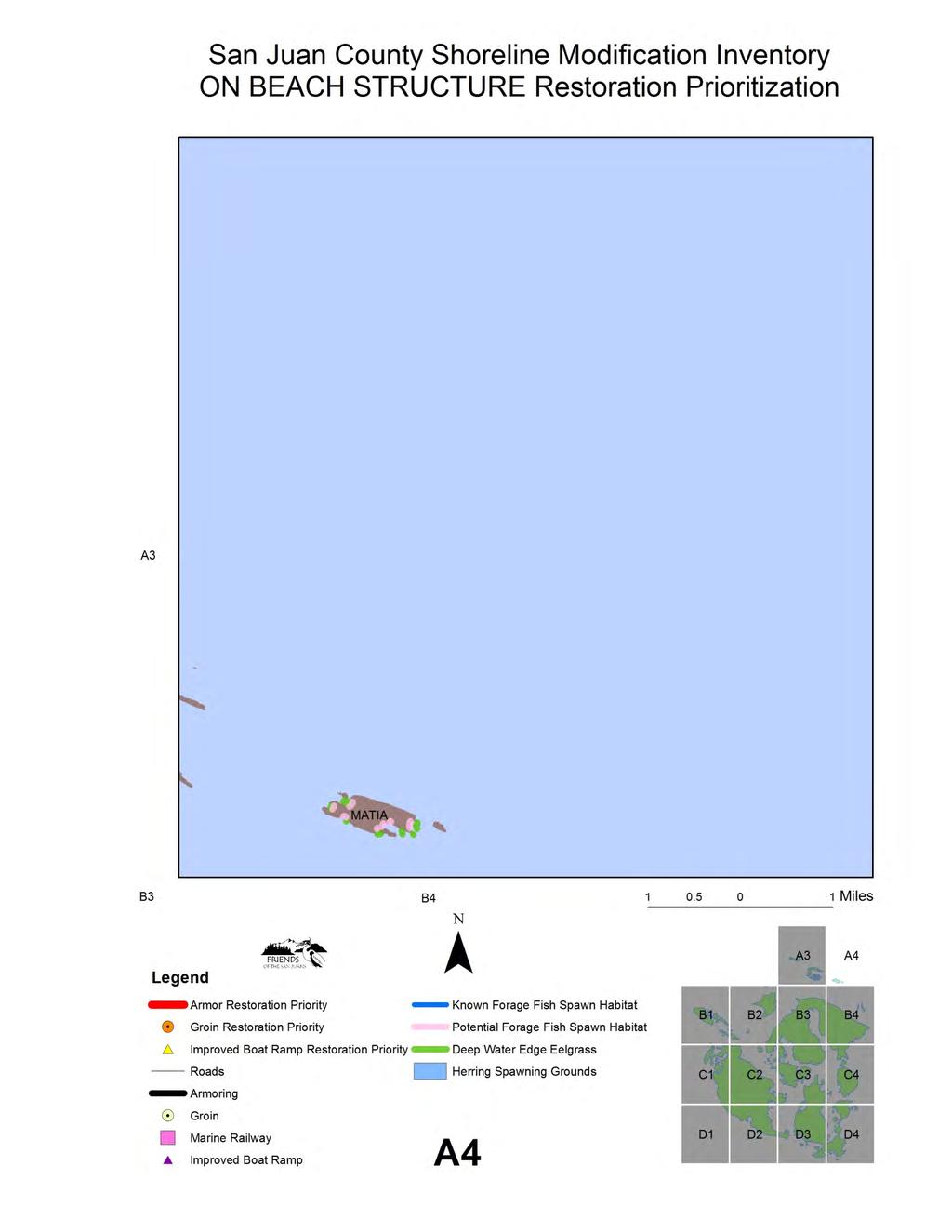
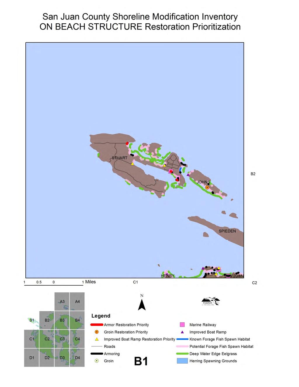
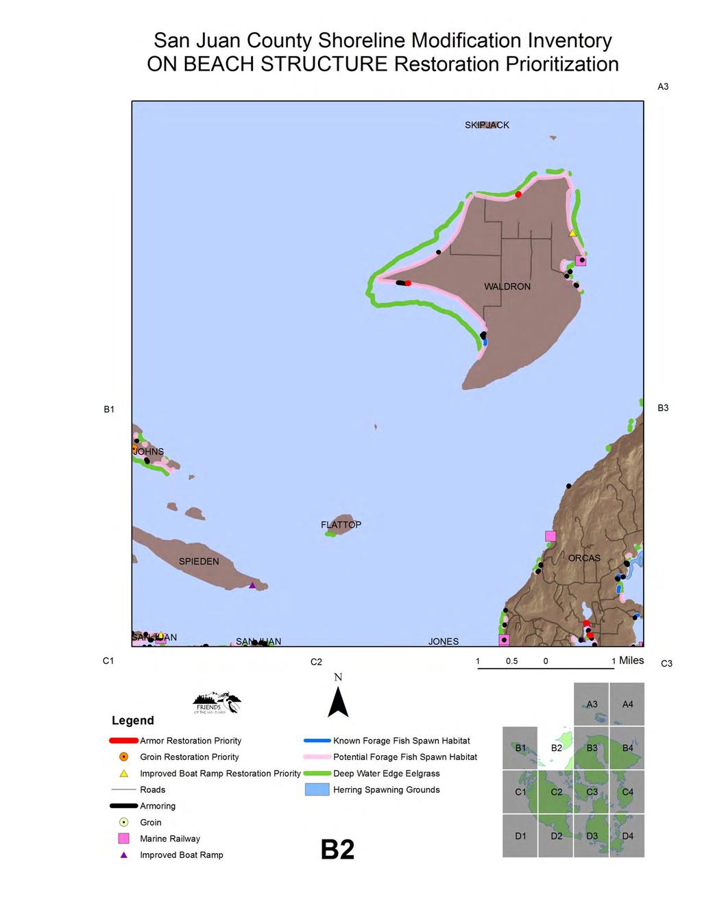
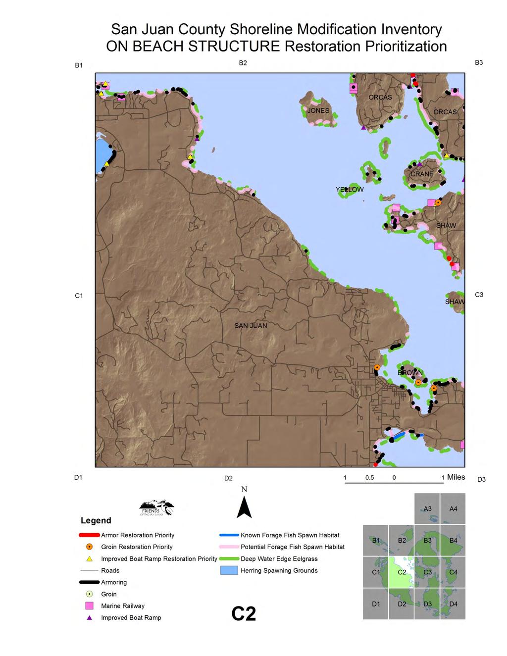
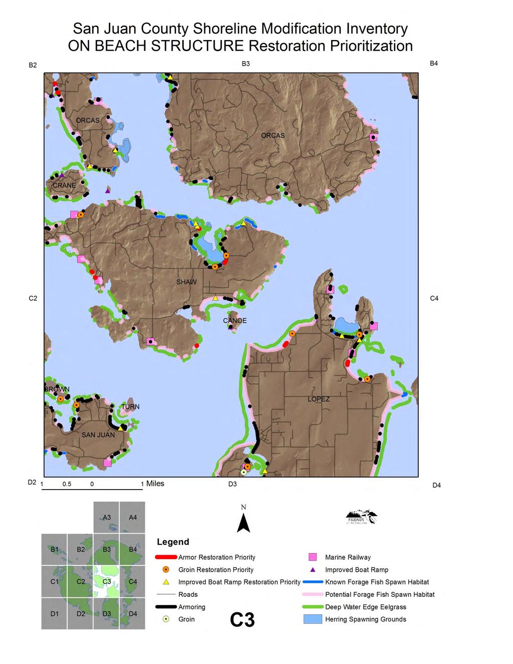
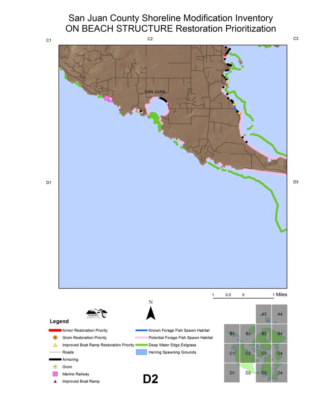
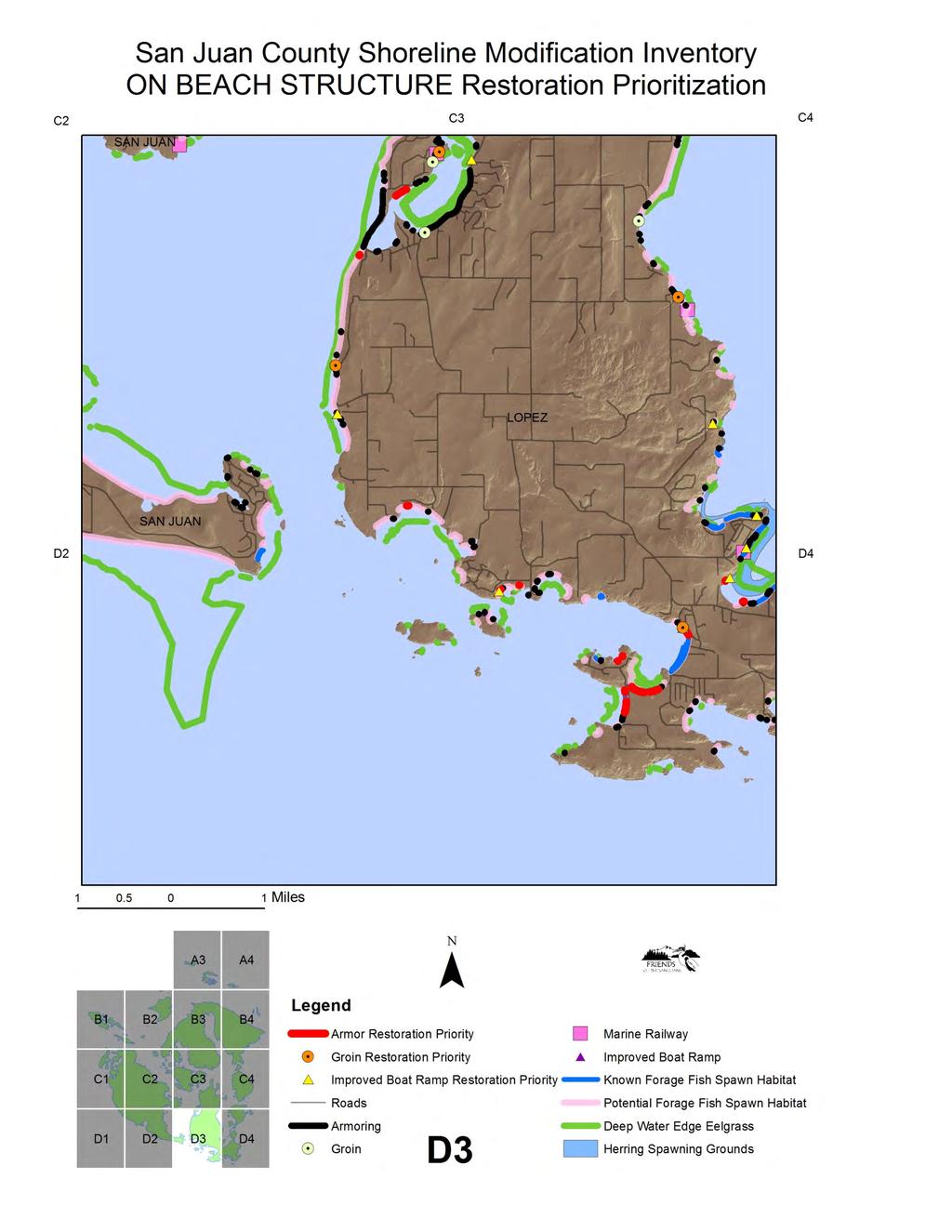
9 Restoration Opportunities- On Beach Structures On-beach shoreline modifications including improved boat ramps, groins and armoring (bulkheads) were analyzed for restoration potential based on a combination of factors including proximity to priority habitats and species including eelgrass, documented surf smelt and/or sand lance spawning beaches and out-migrating juvenile salmon presence. Geomorphic shoretype location and features of the modification itself were also included in the restoration prioritization. Higher priority was assigned for structures located within drift cell systems for their likely off-site impacts to geomorphic processes in addition to the site specific habitat impacts. Ramps and groins were binned into high and moderate restoration ranking categories, while a more detailed, numerical analysis that factored in the feasibility of structure removal in addition to habitat benefits was conducted for shoreline armoring. See Figure 2. On-Beach Structures Restoration Prioritization map book. IMPROVED BOAT RAMPS Seventy improved boat ramps, which includes permanent on-beach structures such as concrete pads were documented along the marine shorelines of San Juan County in the 2009 inventory (FSJ 2010). Boat ramps directly bury intertidal and subtidal habitat and can affect coastal sediment processes that form and maintain beaches. Ramps are often also associated with the removal of marine riparian vegetation and the introduction of pollution and exotic species to the marine environment. Potential habitat restoration opportunities from the removal of improved boat ramps were prioritized based on the proximity to priority habitats and species including eelgrass, forage fish spawning habitat and out-migrating juvenile salmon, as well as whether or not the structure was located in a drift cell system or on a pocket beach geomorphic shoretype. Condition of the structure and likelihood of removal were not included in the ranking criteria for boat ramps. 53 improved boat ramps (76%) were identified as restoration priorities for removal; 26 high priority and 27 moderate priority. 8
10 Table 4. Improved Boat Ramp Removal Prioritization Restoration Priority Ranking Criteria Number of Boat Ramps High Priority-A Improved boat ramp and SJC 8 documented forage fish(surf SJI 0 smelt and/or sand lance) spawn Orcas 1 (100ft) Shaw 3 Lopez 4 High Priority-B Moderate Priority- A Moderate Priority- B Improved boat ramp and drift cell and eelgrass (300 ft) or juvenile salmon (0.5 m) or herring spawning grounds (500 ft) Improved boat ramp and potential forage fish (surf smelt and/or sand lance) spawn (100 ft) and drift cell Improved boat ramp and potential forage fish (surf smelt and/or sand lance) spawn and pocket beach Outer Islands 0 SJC 26 SJI 5 Orcas 7 Shaw 1 Lopez 7 Outer Islands 6 SJC 20 SJI 3 Orcas 5 Shaw 1 Lopez 4 Outer Islands 7 SJC 29 SJI 8 Orcas 11 Shaw 3 Lopez 4 Outer Islands 3 GROINS Thirty two groins were documented along the marine shorelines of San Juan County (FSJ 2010). The lower elevation of all documented groins was below the water line at the time of the survey. Upper beach elevations of groin structures ranged from +2 M.L.L.W. to +9 M.L.L.W., with a mean of +3.8 M.L.L.W.(FSJ 2010). Groin elevation can play an important role in evaluating potential or likely impacts to habitat and habitat forming processes such as burial of forage fish spawning substrate and disruption of sediment transport. Groins directly bury intertidal and subtidal habitats and interrupt the natural coastal sediment processes that form and maintain beaches. Potential habitat restoration opportunities from the removal of groins were prioritized based on the proximity to priority habitats and species including eelgrass, forage fish spawning habitat and outmigrating juvenile salmon, as well as whether or not the structure was located in a drift cell system or on a pocket beach geomorphic shoretype. Condition of the structure and likelihood of removal were not included in the ranking criteria for groins. A total of 20 groins (63%) were identified as priorities for removal, including 14 high priority and 6 moderate priority sites. 9
 spawn (100ft) High Priority-B")
11 Table 5. Groin Removal Prioritization Restoration Priority Ranking Criteria Number of Groins High Priority-A Groin and documented forage fish (surf smelt and/or sand lance) spawn (100ft) High Priority-B Moderate Priority-A Moderate Priority-B Groin and drift cell and eelgrass (300ft) or juvenile salmon (0.5 mile) or herring spawning grounds (500 ft) Groin and potential forage fish (surf smelt and/or sand lance) spawn (100 ft) and drift cell Groin and potential forage fish (surf smelt and/or sand lance) spawn (100ft) and pocket beach SJC 5 SJI 0 Orcas 0 Shaw 1 Lopez 4 Outer Islands 0 SJC 18 SJI 4 Orcas 0 Shaw 2 Lopez 9 Outer Islands 3 SJC 12 SJI 4 Orcas 0 Shaw 1 Lopez 5 Outer Islands 2 SJC 10 SJI 5 Orcas 1 Shaw 2 Lopez 2 Outer Islands 0 10
. Maximum armor length recorded in the 2009 inventory was 3,513 feet and the mean length of armoring was 137 feet (FSJ 2010).")
12 ARMORING A total of 710 individual modifications were recorded for shoreline armoring, covering over 18 linear miles of SJC s total marine shorelines (FSJ 2010). The minimum armor length recorded was 6.5 feet (FSJ 2010). Maximum armor length recorded in the 2009 inventory was 3,513 feet and the mean length of armoring was 137 feet (FSJ 2010). The majority of armoring, 674 (95%) are associated with residential bulkheads (FSJ 2010). Armoring was also associated with beach access (155), roads (51), boat ramps (20), stormwater outfalls (14), road ends (8), breakwaters (3), groins (3) and jettys (2) (FSJ 2010). Shoreline armoring including riprap, retaining walls, bulkheads, and other forms of shoreline armoring structures can have a number of adverse impacts on the marine shoreline environment. The adverse effects of these structures can occur through a variety of mechanisms that have been documented (Shipman et al. 2010). These adverse effects are particularly evident in areas where these structures have been constructed below the OHW elevation (Shipman et al. 2010). Development activities, such as clearing vegetation and modifying site drainage, can make erosion worse. Bulkheads and rock walls can reduce erosion caused by wave action, but they often do little to prevent continued erosion and sliding of the upper bank. They will not prevent the beach itself from eroding. In fact, bulkheads can cause increased erosion of the beach when waves reflect off the hard structure and erode nearby shorelines (Shipman et al. 2010). 1,096 shoreline tax parcels (24%) had armoring present in the 2009 surveys (FSJ 2010). As documented by the San Juan Initiative s Case Study (MacLennan and Johannessen 2008), armoring was concentrated on sand/gravel or soft, non-rock shorelines. When analyzed with tax parcels on the approximately 320 miles of rocky shorelines removed, the proportion of armored soft shore shoreline tax parcels increases to nearly half of shoreline parcels (49%) (FSJ 2010). While just 4% of the total marine shorelines within San Juan County are armored, the percent armored jumps to 22.5% for the 80 miles of sand/gravel shorelines (FSJ 2010). The majority of shoreline armoring consists of large rock (505), followed by small rock (364), wood (182), creosote wood (56), concrete (140) and gabion basket (9) construction (FSJ 2010). While the 11
.")
13 majority of armoring was in good condition (483), a significant proportion, (200) were in degraded or poor condition (FSJ 2010). The waterward toe of bulkhead elevations ranged from a minimum of -2 M.L.L.W. to a high of + 11 M.L.L.W., with a mean of +5.7 M.L.L.W.(FSJ 2010). These results indicate that the majority of bulkheads are located where they are directly impacting intertidal habitats through burial. As one example of direct habitat impacts, forage fish spawning and incubation normally occurs on upper beach habitat within the +7 to +9 M.L.L.W tidal elevation zone (Moulton and Penttila 2001). In addition to direct burial impacts, lower elevation structures also typically have larger indirect effects such as increased erosion at the ends and toe of the structure, bulkhead associated vegetation removal and loss of fine sediments over time on the beach face. All sites with greater than 5 linear shoreline feet of armoring were included in the restoration prioritization. The numerical ranking included removal feasibility criteria as well as scores based on habitat benefit. Scoring criteria were adapted from an earlier Friends of the San Juans project completed in partnership with Coastal Geologic Services, the Soft Shore Restoration Blueprint for Forage Fish Spawning Beaches in San Juan County, Washington (Johannessen and MacLennan 2006). Changes to the scoring reflect the improved level of detail now available, such as bulkhead condition and location information from the modification inventory project as well as geomorphic mapping results that allow us to site projects within their drift cell context. The 48 potential armor removal restoration sites (residential bulkheads or armored roads) with the highest combined feasibility and habitat value scores are considered the best opportunities for restoration. Top ranked sites include multiple County roads as well as residential bulkheads. Armor removal projects with the top five scores (combined scores of 30 and above- see Tables 6 and 7 for armor removal feasibility and habitat benefit scoring and rationale) included potential restoration project locations on southwest Decatur Island, multiple south Lopez Island sites, such as Barlow Bay, Agate Beach, MacKaye Harbor and additional smaller pocket beaches and Blind Bay, Shaw Island. Outreach efforts to identify landowners interested in exploring restoration opportunities are underway and some match funds have been secured to provide technical site visits to willing landowners and explore restoration alternatives. 12
14 Table 6. Armor Removal Feasibility Scoring and Rationale Feasibility Factor & Score 1. Armor Condition a) Good or unknown (0) b) Mixed (1) c) Poor (3) 2. Fetch a) > 12 miles (0) b) miles (1) c) miles (2) d) miles (3) e) 0-3 miles (4) 3. Aspect/orientation a) South (0) b) North (1) c) West and east (2) 4. Adjacent shores a) Modified (0) b) Unmodified soft shore (1) c) Unmodified bedrock shore (2) 5. Adequate setback (distance to structure) a) 0-25 ft (0) b) ft (1) c) ft (2) d) > 75 ft (3) 6. Location in drift cell and pocket beaches a) Feeder bluff exceptional (0) b) Feeder bluff (1) c) Transport zone (2) d) Accretionary shores (5) e) Pocket beach (3) Rationale Bulkheads in degraded or failed condition are likely candidates for repair or replacement in the short term, providing an opportunity for removal or alternative shore protection design. In addition, current landowner investment in the structure is likely lower. Higher energy beaches have greater erosion potential and are less successful nourishment projects. Exposure to prevailing/predominant winds (southerlies) is associated with more frequent high wave energy events thus more rapid erosion rates. Modifications can result in end effects or exacerbated erosion on the adjacent shore. Unmodified high elevation banks may provide some natural sediment into the beach system. Bedrock often acts as a headland- and traps sediment, increasing the long-term sustainability of the project. Enables some erosion to occur over the long term, reduces risk to homes/infrastructure. Sites near the drift cell origin (feeder bluffs) are more likely to be erosive. Mid cell, no appreciable drift areas and pocket beaches typically have negligible erosion/accretion, and the cell terminus is often accretionary- thus possessing greater long term project sustainability (sediment retention). Note: scoring criteria adapted from Johannessen, J. and A. MacLennan Soft shore restoration blueprint for forage fish spawning beaches in San Juan County, Washington. In partnership with Friends of the San Juans. Report to the WA State Salmon Recovery Funding Board. 13
15 Table 7. Armor Removal Habitat Enhancement Value Scoring and Rationale Habitat Enhancement Value Factor & Score 7. Armor length a) <50 ft (1 pt) b) ft (2) c) ft (3) d) ft (4) e) 500+ ft (5) 8. Armor elevation a) < 0 MLLW (7) b) 0 to 3 MLLW (6) c) 3 to 6 MLLW (5) d) 7 to 10 MLLW (4) e) > 10 MLLW (2) 9. Proximity to documented forage fish (surf smelt or sand lance) spawning habitat (100 ft) (8) 10. Proximity to potential forage fish (surf smelt or sand lance) spawning habitat (100 ft) (2) 11. Location in a priority restoration feeder bluff (within 100 ft) (3) 12. Proximity to freshwater (500 ft) (2) 13. Proximity to outmigrating juvenile salmon (0.5 miles) (2) 14. Proximity to eelgrass (300 ft) (2) 15. Proximity to herring spawning grounds (300 ft) (2) Habitat Benefit Rationale Rehabilitation of long modifications provides greater benefits as greater length of intertidal area typically provides greater benefit versus cost. Modification elevations are relative to MLLW. Low elevation modifications eliminate forage fish spawning habitat, reduce shoreline connectivity and increase the risk of predation of outmigrating juvenile salmon. Documented forage fish spawning habitat is of more value due to their known presence and the species propensity for site fidelity. Documented forage fish spawning habitat is of more value due to their known presence and the species propensity for site fidelity. Feeder bluffs provide sediment to entire drift cell systems, maintaining beaches beyond the project site scale. Estuarine nearshore conditions (Osmoregulation- physiological support for outmigrating juvenile salmon). Also a source of nutrients and terrestrial insects transfer from upland to marine environment. In an area known to be utilized by outmigrating juvenile salmon as they pass through the shallow waters of San Juan County. In time, armoring can change sediment conditions in front of the structure, causing a loss of the fine sediments eelgrass requires to grow. In San Juan County, eelgrass is the predominant submerged aquatic vegetation utilized for spawning by Pacific herring. Armored shores can also cause site specific increases in predation risk for small fish. Note: scoring criteria adapted from Johannessen, J. and A. MacLennan Soft shore restoration blueprint for forage fish spawning beaches in San Juan County, Washington. In partnership with Friends of the San Juans. Report to the WA State Salmon Recovery Funding Board. 14
16 Conclusions The majority of shoreline development activity in San Juan County occurs through incremental single-family development and individual shoreline alterations. The magnitude of these impacts may only become evident cumulatively over time. In addition, significant county infrastructure is located in close proximity to marine shorelines and is negatively impacting habitat and habitat forming processes. Many degraded, outdated or unnecessary shoreline structures were documented in the 2009 Shoreline Modification Inventory for San Juan County. The shoreline modification restoration prioritization identifies important restoration opportunities for improving nearshore marine habitat conditions at public and private sites across the county. The location of most modifications along non rocky shorelines means that impacts are concentrated in areas important to forage fish spawning habitat as well as the coastal sediment processes critical to forming and maintaining local beaches. With just 12 miles of documented forage fish spawning habitat and a limited number of feeder bluffs in San Juan County, restoration actions as well as improved protections will be needed to ensure maintenance of these and other important habitats and processes over the long term. Restoration prioritization results can be applied by restoration practitioners, private landowners, managers of public infrastructure, and policy makers. For example, the large number of degraded bulkheads presents a significant opportunity to restore habitat through structure removal where feasible or habitat enhancement through rebuilding structures in a less impactful location and design, such as soft shore protection. Outdated mooring buoy installations located in priority eelgrass or herring spawning habitats can be upgraded to less impactful designs, or relocated, away from the most sensitive habitats. In some cases, landowners may be willing to consider removal of existing modifications, particularly where they are in poor condition or not serving any current purpose. The county itself, through its oversight of public infrastructure, has a major opportunity to improve habitat, as well as the long term viability of infrastructure, through relocation of roads away from critical habitats and implementation of improved maintenance and repair practices at remaining structures such as boat ramps and docks. San Juan County s marine shorelines provide numerous forage fish spawning sites, eelgrass meadows, kelp beds, and feeding, refuge and migration corridors for salmon, seabirds and marine mammals. The success of regional salmon and orca recovery efforts is critically dependent on the protection and restoration of habitats and habitat forming processes. However, sensitive nearshore ecosystems in the San Juans and throughout Puget Sound are suffering from the ongoing impacts of shoreline modification activities. Shoreline modifications pose a significant threat to the ecological functioning of coastal systems. The cumulative impact of human modifications on nearshore habitats and shoreline processes that sustain them may be far-reaching, particularly in light of anticipated increases in sea level and storm-induced erosion. A combination of improved protection for intact shorelines and restoration of degraded sites is needed. 15
17 References Bargmann, G Forage Fish Management Plan. A plan for managing the forage fish resources of Washington. Washington Department of Fish and Wildlife. Olympia, WA. 66 p. Beamer, E., K. Fresh, R. Henderson, and T. Wyllie-Echeverria Skagit River System Cooperative--Preliminary findings of the Habitat Based Assessment of Juvenile Salmon Project. Salmon Recovery Technical Workshop Proceedings. Friday Harbor, Washington. ENVIROVISION, HERRERA, AND AHG III -20 OCTOBER 2007 Protecting Nearshore Habitat and Functions in Puget Sound: An Interim Guide. Erstad, P Draft Priority Habitats and Species recommendations: Bulkheads and shoreline armoring. Washington Department of Fish and Wildlife, Olympia, Washington. Fletcher, C.H., R.A. Mullane, B.M. Richmond, Beach loss along armored shoreline on Oahu, Hawaiian Islands, Journal of Coastal Research, vol. 13, no. 1, p Fresh, K.L Juvenile Pacific Salmon in Puget Sound. Puget Sound Nearshore Partnership Report No Published by Seattle District, U.S. Army Corps of Engineers, Seattle, Washington. Friends of the San Juans Forage Fish Spawning Habitat Assessment and a Summary of Protection and Restoration Priorities for San Juan County Washington. Final Project Report. Friday Harbor, WA. Friends of the San Juans Eelgrass Mapping Project for San Juan County Washington. Final Project Report to the Washington State Salmon Recovery Funding Board. In partnership with the University of Washington and the Washington Department of Natural Resources. Friday Harbor, WA. Friends of the San Juans Exploratory Pacific herring spawn surveys for San Juan County Washington. Final Project Report to the Washington State Salmon Recovery Funding Board. Friday Harbor, WA. Griggs, G.B., The impacts of coastal armoring. Shore and Beach, vol. 73, no. 1, Winter, p Johannessen, J.W. and A.J. MacLennan, Soft Shore Protection/Structure Removal Blueprint for San Juan County Forage Fish Beaches. Prepared for Friends of the San Juans, 40 p. Johannessen, J. and A. MacLennan Beaches and Bluffs of Puget Sound. Puget Sound Nearshore Partnership Report No Published by Seattle District, U.S. Army Corps of Engineers, Seattle, Washington. Karrow, N.A., H.J. Boermans, D.G. Dixon, A. Hontella, K.R. Solomon, J.J. Whyte, and N.C. Bols Characterizing the immunotoxicity of creosote to rainbow trout (Oncorhynchusmykiss): A microcosm study. Aquatic Toxicology 45(4): Cited in Stratus 2005a. Leschine, T.M. and A.W. Petersen Valuing Puget Sound s Valued Ecosystem Components. Puget Sound Nearshore Partnership Report No Published by Seattle District, U.S. Army Corps of Engineers, Seattle, Washington. 16
18 MacDonald, K. D. Simpson, B. Paulsen, J. Cox, and J. Gendron, Shoreline Armoring Effects on Physical Coastal Processes in Puget Sound, Washington. Coastal Erosion Management Studies Volume 5. Shorelands and Water Resources Program, Washington Department of Ecology, Olympia. Report # Moulton, L. L. and D. E. Penttila, Field manual for sampling forage fish spawn in intertidal shore regions and the Distribution of potential surf smelt and Pacific sand lance spawning habitat in San Juan County. MJM Research and Washington Department of Fish and Wildlife for the San Juan County Forage Fish Project. Penttila, D.E Documented spawning areas of the Pacific herring (Clupea), surf smelt (Hypomesus), and Pacific sand lance (Ammodytes) in San Juan County, Washington. Washington Dept. of Fish and Wildlife, Marine Resources Division. Manuscript Report. LaConner, WA. 27p. Penttila, D Marine Forage Fishes in Puget Sound. Puget Sound Nearshore Partnership Report No Published by Seattle District, U.S. Army Corps of Engineers, Seattle, Washington. Poston, T Treated Wood Issues Associated with Overwater Structures in Marine and Freshwater Environments. Prepared for the Washington Department of Fish and Wildlife, Washington Department of Ecology, and Washington Department of Transportation. Redman, Scott, and Fresh, Kurt, Regional Nearshore and Marine Aspects of Salmon Recovery, Puget Sound Action Team and NOAA Fisheries Olympia/Seattle. Rice, C Effects of Shoreline Modification on a Northern Puget Sound Beach: Microclimate and Embryo Mortality in Surf Smelt (Hypomesus pretiosus). Estuaries and Coasts. Vol 29, No. 1. p San Juan County Marine Resources Committee Marine Stewardship Area Conservation Action Plan. San Juan County and The Nature Conservancy, Friday Harbor, Washington. San Juan Initiative San Juan Initiative Protection Assessment Nearshore Case Study Area Characterization. San Juan County and the Puget Sound Partnership. Shared Strategy Puget Sound Chinook salmon recovery plan. Seattle, Washington. Shipman, H., Dethier, M.N., Gelfenbaum, G., Fresh, K.L., and Dinicola, R.S., eds. 2010, Puget Sound Shorelines and the Impacts of Armoring-Proceedings of a state of the science workshop, May 2009: U.S. Geological Survey Scientific Investigations Report , 266 p. Stratus (Stratus Consulting Inc., Duke University). 2005a. Creosote Treated Wood in Aquatic Environments: Technical Review and Use Recommendations. Prepared for the National Oceanic and Atmospheric Administration s National Marine Fisheries Service. Thom, R., Shreffler, D., and Macdonald, Keith, Shoreline armoring effects on coastal ecology and biological resources in Puget Sound, Washington: Coastal Erosion Management Studies. Vines, C.A., T. Robbins, F.J. Griffin, and G.N. Cherr The effects of diffusible creosote derived compounds on development in Pacific herring (Clupea pallasi). Aquatic Toxicology 51: Cited in Stratus 2005a. 17
19 Figure 1.
20
21
22
23
24
25
26
27
28
29
30
31
32
33
34 Figure. 2
35
36
37
38
39
40
41
42
43
44
45
46
47
48
Shoreline Modification Inventory for San Juan County, Washington
 Shoreline Modification Inventory for San Juan County, Washington Mud/Hunter Bay Region, Lopez July 2010 Friends of the San Juans P.O. Box 1344 Friday Harbor, WA 98250 www.sanjuans.org Shoreline Modification
The Cumulative Effects of Shoreline Armoring on Forage Fish Spawning Beach Habitat in San Juan County, Washington.
 The Cumulative Effects of Shoreline Armoring on Forage Fish Spawning Beach Habitat in San Juan County, Washington. Tina Whitman, Science Director Friends of the San Juans August 2011 Prepared for the Bullitt
Puget Sound Shorelines. Waves and coastal processes. Puget Sound shorelines: Effects of beach armoring
 Puget Sound Shorelines Puget Sound shorelines: Effects of beach armoring Waves and coastal processes Factors affecting wave energy hitting the coast Processes transporting sediment along coastlines What
Blakely Island, N Thatcher Bay. Restoration Recommendation: Rank Score (total score)
") Soft Shore Protection/Structure Removal Blueprint for San Juan County Forage Fish Beaches Appendix 2: Recommendations for sites scoring below the top ten, sorted by island (east to west) Blakely Island,
Soft Shore Protection/Structure Removal Blueprint for San Juan County Forage Fish Beaches Appendix 2: Recommendations for sites scoring below the top ten, sorted by island (east to west) Blakely Island,
The Cumulative Impacts of Shoreline Armoring on Forage Fish Spawning Habitat in San Juan County, Washington
 Western Washington University Western CEDAR Salish Sea Ecosystem Conference 2014 Salish Sea Ecosystem Conference (Seattle, Wash.) May 1st, 1:30 PM - 3:00 PM The Cumulative Impacts of Shoreline Armoring
Analysis of Shoreline Permit Activity in San Juan County, Washington
 Analysis of Shoreline Permit Activity in San Juan County, Washington 1972-2005 Aerial Photo of Fisherman s Bay, Lopez Island by Mark Gardner Tina Whitman Friends of the San Juans P.O. Box 1344 Friday Harbor,
Puget Sound Nearshore Ecosystem Restoration Project Restore America s Estuaries Conference 2012 Tampa, FL
 Restore America s Estuaries Conference 2012 Tampa, FL presented by: Theresa Mitchell, WA Dept. of Fish & Wildlife Nearshore General Investigation Change Analysis: Comparison of historical and current
Thanks to: -Current and former Habitat staff -Fish Program Marine Fish Division & Region 6 Staff
 Thanks to: -Current and former Habitat staff -Fish Program Marine Fish Division & Region 6 Staff - Overview Intro to forage fish What they are and why are they important Nearshore Forage Fish Habitat surveys
11426 Moorage Way P.O. Box 368 LaConner, WA Phone: Fax:
 Skagit River System Cooperative 11426 Moorage Way P.O. Box 368 LaConner, WA 98257-368 Phone: 36-466-7228 Fax: 36-466-447 www.skagitcoop.org BULL TROUT USE OF SWINOMISH RESERVATION WATERS Eric Beamer, Rich
living with the shoreline A Stewardship Guide for San Juan County Property Owners
 living with the shoreline A Stewardship Guide for San Juan County Property Owners living with the shoreline A Stewardship Guide for San Juan County Property Owners The San Juan Islands and the Northwest
Habitat Development: Habitat Boulders Lawson Pier Foreshore Enhancement
 Habitat Development: Habitat Boulders Improve the existing habitat by stabilising beach sediments. Increase biodiversity by creating new habitats and colonisation opportunities. Loose cobble is unstable;
FISHERIES BLUE MOUNTAINS ADAPTATION PARTNERSHIP
 FISHERIES A warming climate, by itself, substantially affects the hydrology of watersheds in the Blue Mountains. Among the key hydrologic changes projected under all scenarios for the 2040s and beyond
ALTERNATIVES FOR COASTAL STORM DAMAGE MITIGATION
 ALTERNATIVES FOR COASTAL STORM DAMAGE MITIGATION Dave Basco Old Dominion University, Norfolk, Virginia, USA National Park Service Photo STRUCTURAL (changes to natural, physical system) hardening (seawalls,
CHAPTER 4 DESIRED OUTCOMES: VISION, GOALS, AND OBJECTIVES
 CHAPTER 4 DESIRED OUTCOMES: VISION, GOALS, AND OBJECTIVES Vision One of the first steps in developing this Plan was articulating a vision - a clear statement of what the Plan strives to achieve and what
Essential Fish Habitat Consultation
 1 Essential Fish Habitat Consultation Marine Shoreline Development Workshop February 21, 2007 John H. Stadler Washington State Habitat Office National Marine Fisheries Service Magnuson-Stevens Fishery
Estuarine Shoreline Stabilization
 Estuarine Shoreline Stabilization Property Owner s Guide to Determining the Most Appropriate Stabilization Method Estuarine shorelines are dynamic features that experience continued erosion. Land is lost
ALTERNATIVES FOR COASTAL STORM DAMAGE MITIGATION AND FUNCTIONAL DESIGN OF COASTAL STRUCTURES
 The University of the West Indies Organization of American States PROFESSIONAL DEVELOPMENT PROGRAMME: COASTAL INFRASTRUCTURE DESIGN, CONSTRUCTION AND MAINTENANCE A COURSE IN COASTAL DEFENSE SYSTEMS I CHAPTER
Assessment of Creosote-Treated Structures and Other Artificial Substrates in San Francisco Bay
 Assessment of Creosote-Treated Structures and Other Artificial Substrates in San Francisco Bay Jennifer Hunt, Christine Werme, Kristen Cayce, Marcus Klatt, William Winner, Erin Beller, Eric Polson, Robin
COMMENTS ON SEATTLE DISTRICT 2017 NATIONWIDE PERMIT GENERAL REGIONAL CONDITIONS AND SPECIFIC REGIONAL CONDITIONS
 State of Washington DEPARTMENT OF FISH AND WILDLIFE Mailing Address: 600 Capitol Way N, Olympia, WA 98501-1091 (360) 902-2200 TDD (360) 902-2207 Main Office Location: Natural Resources Building, 1111 Washington
FISH PASSAGE IMPROVEMENT in California s Watersheds. Assessments & Recommendations by the Fish Passage Forum
 FISH PASSAGE IMPROVEMENT in California s Watersheds Assessments & Recommendations by the Fish Passage Forum FISH PASSAGE IMPROVEMENT in California s Watersheds The mission of the Fish Passage Forum is
Proposed Terrestrial Critical Habitat for the Northwest Atlantic Loggerhead Sea Turtle Population. U.S. Fish and Wildlife Service
 Proposed Terrestrial Critical Habitat for the Northwest Atlantic Loggerhead Sea Turtle Population U.S. Fish and Wildlife Service History of Loggerhead Listing (joint responsibility USFWS and NOAA Fisheries)
KUKUTALI PRESERVE JUVENILE CHINOOK SALMON AND FORAGE FISH ASSESSMENT
 KUKUTALI PRESERVE JUVENILE CHINOOK SALMON AND FORAGE FISH ASSESSMENT Eric Beamer, Josh Demma, and Rich Henderson Skagit River System Cooperative LaConner, WA March 2014 Report prepared for: Swinomish Indian
The Blue Heron Slough Conservation Bank
 1 The Blue Heron Slough Conservation Bank CONSERVATION BANKING July 19-23, 2010 CASE STUDY SERIES The Blue Heron Slough Conservation Bank (Washington) I. OVERVIEW & BACKGROUND: Location: Snohomish River
Essential Fish Habitat OCNMS Advisory Council July 13, 2013
 Essential Fish Habitat OCNMS Advisory Council July 13, 2013 John Stadler Habitat Conservation Division NMFS Northwest Region Essential Fish Habitat (EFH) What is it, where did it come from, and what does
TITLE: North Carolina s Changing Shorelines. KEYWORDS: erosion - shorelines - mapping - sustainability
 UNC Coastal Studies Institute Teacher Resources 1 TITLE: North Carolina s Changing Shorelines KEYWORDS: erosion - shorelines - mapping - sustainability Changing shorelines impact coastal infrastructure.
Delaware Chapter Surfrider Foundation - Indian River Inlet Monitoring
 Delaware Chapter Surfrider Foundation - Indian River Inlet Monitoring In 2012, the Delaware Surfrider Foundation Chapter formed the Surf Quality and Access Committee to focus on issues such as surf spot
The Salmonid Species. The Salmonid Species. Definitions of Salmonid Clans. The Salmonid Species
 The Salmonid Species The Salmonid Species N. American salmon (2 more Asian species) Chinook ( King ) Coho ( Silver ) Sockeye Chum ( Dog ) Pink ( Humpy ) Sea-run trout Steelhead, Cutthroat, Dolly Varden
I. Monitoring and Adaptive Management Approach. Potential Effects, Monitoring Studies & Mitigation
 I. Monitoring and Adaptive Management Approach Define the problem or management objective. Determine potential effects of the project on indicator species. Emphasis on examining potentially negative, rather
Black Sturgeon Regional Plan
 Black Sturgeon Regional Plan This is one of twenty Regional Plans that support implementation of the Lake Superior Biodiversity Conservation Strategy (Strategy). The Strategy, prepared and overseen by
Inventory and Mapping of City of Seattle Shorelines along Lake Washington, the Ship Canal, and Shilshole Bay
 SAFS-UW-0302 April 2003 Inventory and Mapping of City of Seattle Shorelines along Lake Washington, the Ship Canal, and Shilshole Bay J TOFT, C SIMENSTAD, C YOUNG, L STAMATIOU Wetland Ecosystem Team University
Chagrin River TMDL Appendices. Appendix F
 Appendix F The following are excerpts from the Eastern Brook Trout Joint Venture s Conservation Strategy (Working Draft v.6), Conserving the Eastern Brook Trout: Strategies for Action Found at: http://www.easternbrooktrout.org/constrategy.html
Michael Tehan, Assistant Regional Administrator, Interior Columbia Basin Office
 UNITED STATES DEPARTMENT OF COMMERCE National Oceanic and Atmospheric Administration NATIONAL MARINE FISHERIES SERVICE Northwest Fisheries Science Center Fish Ecology Division 2725 Montlake Boulevard East
EXHIBIT ARWA-700 TESTIMONY OF PAUL BRATOVICH
 EXHIBIT ARWA-700 TESTIMONY OF PAUL BRATOVICH 1. I am a fisheries biologist employed by the firm of HDR, Inc. I hold a Bachelor of Science degree in Fisheries from the University of Washington, located
DRAFT TECHNICAL MEMORANDUM
 DRAFT TECHNICAL MEMORANDUM From: File No.: 213.001 Re: Beaux Arts Village Shoreline - 2016 Introduction The Washington Academy of Beaux Arts (WABA) completed shoreline habitat restoration at three locations
Feasibility Study for Restoration of Titlow Lagoon Fish Passage. South Puget Sound Salmon Enhancement Group
 Feasibility Study for Restoration of Titlow Lagoon Fish Passage South Puget Sound Salmon Enhancement Group January 2010 Feasibility Study for Restoration of Titlow Lagoon Fish Passage Prepared for South
Project Webpage:
 Project Webpage: http://nature.ly/marinesatlanticbightera Coastal Data and Full Metadata: http://easterndivision.s3.amazonaws.com/marine/sab MA/SABMACoastalEcosystems.zip Coastal Chapter: http://easterndivision.s3.amazonaws.com/marine/sab
Warm-up # 7 A day 5/17 - B day 5/18 UPDATE YOUR TABLE OF CONTENTS
 Warm-up # 7 A day 5/17 - B day 5/18 UPDATE YOUR TABLE OF CONTENTS Question: List all examples of surface water on Earth. Answer: Rivers and streams, lakes and reservoirs, (ponds) wetlands, estuaries and
Juvenile salmon use of estuaries Functional performance of restoring and natural habitats Ecological effects of shoreline modifications.
 Juvenile salmon use of estuaries Functional performance of restoring and natural habitats Ecological effects of shoreline modifications Jason Toft Jason Toft It s my birthday! CMR GPR GPC PA P2AR NC RIR
North Shore of Long Island, Feasibility Study
 North Shore of Long Island, Asharoken New York Asharoken, Feasibility Study Asharoken, NY Public Meeting June 30, 2015 US Army Corps of Engineers US Army Corps of Engineers New York BUILDING STRONG BUILDING
EVALUATING THE EFFECTS OF BIVALVE SHELLFISH AQUACULTURE AND ITS ECOLOGICAL ROLE IN THE ESTUARINE ENVIRONMENT IN THE UNITED STATES
 EVALUATING THE EFFECTS OF BIVALVE SHELLFISH AQUACULTURE AND ITS ECOLOGICAL ROLE IN THE ESTUARINE ENVIRONMENT IN THE UNITED STATES Brett Dumbauld USDA Agricultural Research Service, Hatfield Marine Science
STATUS REPORT FOR THE SUBMERGED REEF BALL TM ARTIFICIAL REEF SUBMERGED BREAKWATER BEACH STABILIZATION PROJECT FOR THE GRAND CAYMAN MARRIOTT HOTEL
 August 23 STATUS REPORT FOR THE SUBMERGED REEF BALL TM ARTIFICIAL REEF SUBMERGED BREAKWATER BEACH STABILIZATION PROJECT FOR THE GRAND CAYMAN MARRIOTT HOTEL performed by Lee E. Harris, Ph.D., P.E. Consulting
X.B WETLANDS ROGUE RIVER ESTUARY
 X.B WETLANDS ROGUE RIVER ESTUARY The Rogue River has a drainage area of 5,100 square miles, yet the estuary of the Rogue River is one of the smallest in Oregon, measuring approximately 1,880 acres during
Oregon Estuaries defined: (Goal 16)
") Bob Bailey, Manager, Oregon Coastal Management Program Oregon Estuaries defined: (Goal 16) includes estuarine water, tidelands, tidal marshes, and submerged lands. Estuaries extend upstream to the head
Bob Bailey, Manager, Oregon Coastal Management Program Oregon Estuaries defined: (Goal 16) includes estuarine water, tidelands, tidal marshes, and submerged lands. Estuaries extend upstream to the head
Lake Tahoe Shoreline Plan. 05 Policy Topic: Piers- Fish Habitat, Design, and Scenic Issues
 Lake Tahoe Shoreline Plan 05 Policy Topic: Piers- Fish Habitat, Design, and Scenic Issues 07.20.2016 1 Brief Description There are 768 piers located along the shoreline of Lake Tahoe. Approximately 43
MUCKLESHOOT INDIAN TRIBE Fisheries Division nd Avenue SE Auburn, Washington Phone: (253) Fax: (253)
 Fax: (253)") MUCKLESHOOT INDIAN TRIBE Fisheries Division 39015-172nd Avenue SE Auburn, Washington 98092-9763 Phone: (253) 939-3311 Fax: (253) 931-0752 U.S. Army Corps of Engineers Regulatory Branch Attn: Karen Urelius
MUCKLESHOOT INDIAN TRIBE Fisheries Division 39015-172nd Avenue SE Auburn, Washington 98092-9763 Phone: (253) 939-3311 Fax: (253) 931-0752 U.S. Army Corps of Engineers Regulatory Branch Attn: Karen Urelius
Fish Community. Fish Habitat, Streams and Rivers
 Clear, Ston(e)y and White Lake Plan Fish Community The lakes support a cool/warm water fishery including muskellunge, walleye, largemouth and smallmouth bass, yellow perch, pumpkinseed, rockbass, blue
Building Coastal Resiliency at Plymouth Long Beach
 Building Coastal Resiliency at Plymouth Long Beach Department of Marine and Environmental Affairs March 30, 2017 Introducing Green Infrastructure for Coastal Resiliency Plymouth Long Beach & Warren s Cove
New Jersey Coastal Zone Overview. The New Jersey Beach Profile Network (NJBPN) 3 Dimensional Assessments. Quantifying Shoreline Migration
 3 Dimensional Assessments. Quantifying Shoreline Migration") New Jersey Coastal Zone Overview The New Jersey Beach Profile Network (NJBPN) Objectives Profile Locations Data Collection Analyzing NJBPN Data Examples 3 Dimensional Assessments Methodology Examples Quantifying
New Jersey Coastal Zone Overview The New Jersey Beach Profile Network (NJBPN) Objectives Profile Locations Data Collection Analyzing NJBPN Data Examples 3 Dimensional Assessments Methodology Examples Quantifying
Habitat Fact Sheets. Rocky habitats are dominated by seaweeds and often mussels, which rely on the rocks for attachment.
 Habitat Fact Sheets Habitats in the Gulf of Maine serve many important roles for the environment and for humans as well. These include: cycling nutrients, filtering pollution, trapping sediments, storing
Eelgrass Survey PARADISE CAY BELVEDERE, MARIN COUNTY CALIFORNIA. Prepared For:
 Eelgrass Survey PARADISE CAY BELVEDERE, MARIN COUNTY CALIFORNIA Prepared For: Radford (Skid) Hall, Ph.D. Land Planning and Permitting Consultant 500 Airport Blvd., Suite 350 Burlingame, CA 94010 (650)
Three point plan to addressing land use and habitat loss impacts on Chesapeake Bay tidal fish and shellfish
 Three point plan to addressing land use and habitat loss impacts on Chesapeake Bay tidal fish and shellfish 1. Establish Principles for Protection of Chesapeake Bay Fish and Shellfish The Fisheries GIT
Good Mooring to You! Jensen Beach Mooring Field. Kathy Fitzpatrick, P.E. Coastal Engineer, Martin County
 Good Mooring to You! Kathy Fitzpatrick, P.E. Coastal Engineer, Martin County Penny Cutt Regional Manager, Coastal Systems International Mooring Field Advantages Provide a safe and secure anchorage at a
Environmental Protection on the Gold Coast of Queensland, Australia. 1. What is the appeal of the Gold Coast to tourists?
 Environmental Protection on the Gold Coast of Queensland, Australia Sections 1. What is the appeal of the Gold Coast to tourists? 2. How are Gold Coast visitor trends changing? 3. How can the impacts of
Restoration of the Nisqually River Delta and increased rearing opportunities for salmonids
 Western Washington University Western CEDAR Salish Sea Ecosystem Conference 2014 Salish Sea Ecosystem Conference (Seattle, Wash.) May 2nd, 8:30 AM - 10:00 AM Restoration of the Nisqually River Delta and
RESILIENCE THROUGH RESTORATION
 RESILIENCE THROUGH RESTORATION RECLAMATION DISTRICT NO. 1601 TWITCHELL ISLAND SAN JOAQUIN RIVER SETBACK LEVEE PROJECT TWITCHELL ISLAND BASICS Nearly 12 miles of levee Storm drainage facilities Protects
Nearshore Habitat Mapping in Puget Sound Using Side Scan Sonar and Underwater Video
 Nearshore Habitat Mapping in Puget Sound Using Side Scan Sonar and Underwater Video Dana Woodruff, Paul Farley, Amy Borde, John Southard, Ron Thom Battelle Marine Sciences Laboratory Jim Norris Marine
Briefing Book - Glossary. Accretion due to stream sediment added naturally to the shore Puget Sound, Everett
 Glossary Accretion: Accretion is the process of adding sediments to a beach, whether naturally (material deposited by water or blown in by the wind) or artificially (material placed by humans). Accretion
USE OF SEGMENTED OFFSHORE BREAKWATERS FOR BEACH EROSION CONTROL
 .. CETN-III-22 4/84 PURPOSE: USE OF SEGMENTED OFFSHORE BREAKWATERS FOR BEACH EROSION CONTROL To provide information on the functional application of and general design considerations for using offshore
Chronic coastal erosion is a statewide problem
 Chronic coastal erosion is a statewide problem 1 Seawalls are constructed where there is erosion, but they do not solve the erosion they often worsen it along adjacent shores. Hawaii needs erosion solutions.
Fisheries Management Zone 10:
 Fisheries Management Zone 10: Lake Trout Operational Objectives and Management Photo Credit: www.jamessmedleyoutdoors.com 2 FMZ 10: Lake Trout Operational Objectives and Management Lake trout are the second
Okanagan Sockeye Reintroduction
 Okanagan Sockeye Reintroduction Backgrounder Elders accounts, and other forms of Traditional Ecological Knowledge (TEK) tell us that many species of salmon once came into the Okanagan Valley and tell us
State of San Francisco Bay 2011 Appendix O Steelhead Trout Production as an Indicator of Watershed Health
 State of San Francisco Bay 2011 Appendix O Steelhead Trout Production as an Indicator of Watershed Health Gordon Becker and Katherine Smetak, Center for Ecosystem Management and Restoration 290 Introduction
Nearshore Sediment Transport What influences the loss of sediment on Beaches? - Waves - Winds - Tidal Currents - River discharge - Runoff
 Tides & Beaches Nearshore Sediment Transport What influences the loss of sediment on Beaches? - Waves - Winds - Tidal Currents - River discharge - Runoff Oceans Ocean Topography Physical Structure of the
Appendix A Recommended EPA Temperature Thresholds for use in Establishing Thermal Potential and Species Life Stage Numeric Criteria
 Appendix A Recommended EPA Temperature Thresholds for use in Establishing Thermal Potential and Species Life Stage Numeric Criteria 1. Temperature Limits Recommended to Protect Salmonid Guilds In this
Chapter 10 Lecture Outline. The Restless Oceans
 Chapter 10 Lecture Outline The Restless Oceans Focus Question 10.1 How does the Coriolis effect influence ocean currents? The Ocean s Surface Circulation Ocean currents Masses of water that flow from one
Executive Summary. Map 1. The Santa Clara River watershed with topography.
 Santa Clara River Steelhead Trout: Assessment and Recovery Opportunities December 2005 Prepared By: Matt Stoecker and Elise Kelley, Ph.D. University of California, Santa Barbara Prepared For: The Santa
Species Conclusions Table
 Conclusions Table Project Name: Chesapeake Landing HOA- Breakwaters (NAO-14-0283) Date: February 25, 2014 /Resource Name Loggerhead sea turtle (Caretta caretta) Conclusion ESA Section 7 / Eagle Act Determination
GONE! Coastal Erosion Happens During Storms! Why Worry About Coastal Setbacks? Goals for Today
 RI Regulatory Setbacks & Buffers: Coastal Zone Management Issues New England Onsite Wastewater Training Program @ URI OWT 155 November 21, 2013 Goals for Today Understand the impacts of storms, coastal
Juvenile Salmon Use of Knik Arm Estuaries. Hannah N. Ramage
 Juvenile Salmon Use of Knik Arm Estuaries Hannah N. Ramage Literature Review Function of estuaries for juvenile salmon Migration pathway Pink salmon use estuaries as a neutral pathway (Simenstad 1982)
Living Shorelines Non-structural Erosion Control Practices Rhode Island Land & Water Summit, 2014
 Living Shorelines Non-structural Erosion Control Practices Rhode Island Land & Water Summit, 2014 D. Steven Brown (1) Kevin Ruddock (1) Rhonda Smith (2) The Nature Conservancy United States Fish and Wildlife
DUNE STABILIZATION AND BEACH EROSION
 DUNE STABILIZATION AND BEACH EROSION CAPE HATTERAS NATIONAL SEASHORE NORTH CAROLINA ROBERT DOLAN PAUL GODFREY U. S. DEPARTMENT OF INTERIOR NATIONAL PARK SERVICE OFFICE OF NATURAL SCIENCE WASHINGTON, D.
Eelgrass and Macroalgae Presence/Absence Preliminary Surveys BHP Proposed Grays Harbor Potash Export Facility A Task 400
 Memorandum 40600-HS-MEM-55036 Revision 0 Date: 26 July 2018 Subject: Eelgrass and Macroalgae Presence/Absence Preliminary Surveys BHP Proposed Grays Harbor Potash Export Facility A17.0202.00 Task 400 INTRODUCTION
County of Santa Barbara Permit Option Analysis Goleta Beach JULY 13, 2017
 County of Santa Barbara Permit Option Analysis Goleta Beach JULY 13, 2017 Introduction 2 Goleta Beach Park welcomes 1.5 million visitors annually Amenities include: Picnic Areas and Group Areas w/bbqs
Managing Chesapeake Bay s Land Use, Fish Habitat, and Fisheries: Studies. Jim Uphoff & Margaret McGinty, Fisheries Service
 Managing Chesapeake Bay s Land Use, Fish Habitat, and Fisheries: Positive Image and or Negative Graphic Case Studies Jim Uphoff & Margaret McGinty, Fisheries Service Maryland Fisheries Service has been
VIMS CCRM Coastal Management Decision Tools. Decision Tree for Undefended Shorelines and Those with Failed Structures
 VIMS CCRM Coastal Management Decision Tools Decision Tree for Undefended Shorelines and Those with Failed Structures Center for Coastal Resources Management Virginia Institute of Marine Science Gloucester
Klickitat County Shoreline Master Program Update. Open House March 15, 2017
 Klickitat County Shoreline Master Program Update Open House March 15, 2017 Agenda 6:00 6:10 Welcome 6:10 6:40 Presentation SMP Update Process Shoreline Analysis review 6:40 8:00 Open House Topics SMP Process
A.23 RIVER LAMPREY (LAMPETRA
 A. RIVER LAMPREY (LAMPETRA AYRESII) A.. Legal and Other Status The river lamprey is a Class (Watch List) California Species of Special Concern (Moyle et al., DFG 0). It has no federal status. A.. Species
RI Regulatory Setbacks & Buffers: Coastal Management Issues
 RI Regulatory Setbacks & Buffers: Coastal Management Issues New England Onsite Wastewater Training Program @ URI OWT 155 - November 29, 2012 James Boyd - Coastal Policy Analyst Photo: October 30, 2012
Five Counties Salmonid Conservation Program - Fish Passage Design Workshop. February 2013
 Program - Aquatic Organisms and Stream Crossings Ecological Connectivity A watershed is a network of channels that drain a common boundary. Channel characteristics formed by interaction of precipitation,
LAB: WHERE S THE BEACH
 Name: LAB: WHERE S THE BEACH Introduction When you build a sandcastle on the beach, you don't expect it to last forever. You spread out your towel to sunbathe, but you know you can't stay in the same spot
Redondo Beach Boat Launch Ramp Facility
 Redondo Beach Boat Launch Ramp Facility Feasibility Report for the California Department of Boating and Waterways 2015 Grant Cycle For the City of Redondo Beach Submitted by March 13, 2014 Table of Contents
Essential Fish Habitat
 Pacific Fishery Management Council Fact sheet: Essential Fish Habitat Habitat is the environment where an animal lives, feeds, and reproduces. Identifying fish habitat is complex because fish move through
Friends of Semiahmoo Bay Society
 Friends of Semiahmoo Bay Society Marine Conservation Initiative Boundary Bay Intertidal Forage Fish Spawning Habitat Project Summary of the Project and Findings July 2006 October 2007 Funding Provided
Report on Science Center Activities
 Agenda Item E.1.b Supp NMFS PowerPoint March 2016 Report on Science Center Activities Columbia River Estuary Habitat Puget Sound Harbor Seal Predation West Coast Salmon GSI Climate Update Evaluating the
Oregon Hatchery Research Center January 2014 David L. G. Noakes, Professor & Director
 Oregon Hatchery Research Center January 2014 David L. G. Noakes, Professor & Director Research Proposal Homing Homing behavior is a striking feature of the biology of Pacific salmon, and is the basis for
MCCAW REACH RESTORATION
 Final Report MCCAW REACH FISH RESTORATION PHASE B Jack McCaw Inland Empire Action Coalition http://www.wwccd.net/ Phone: 509-956-3777 Hours: 8:00-4:30 Walla Walla County Conservation District Snake River
SMP Handbook Chapter 12 Piers, Docks and Overwater Structures
 SMP Handbook Chapter 12 Piers, Docks and Overwater Structures Phase 3, Task 3.4 Shoreline Master Program Planning Process Introduction Piers, docks and other overwater and in-water structures are significant
East Kitsap Peninsula WRIA 15 Salmon Habitat Restoration Strategy Summary
 East Kitsap Peninsula WRIA 15 Salmon Habitat Restoration Strategy Summary I. Specificity and Focus of the Strategy Strategic Planning Area The planning area for the East Kitsap Peninsula Salmon Habitat
Orange County MPA Watch M o n i t o r i n g H u m a n U s a g e
 Orange County MPA Watch M o n i t o r i n g H u m a n U s a g e WHAT IS AN MPA? Marine Protected Areas (MPAs) are discrete geographic marine or estuarine areas designed to protect or conserve marine life
4/20/17. #32 - Coastal Erosion Case Histories - Lake Michigan
 Writing Assignment Due Monday by 11:59 pm #32 - Coastal Erosion Case Histories - Lake Michigan See main class web pages for detailed instructions Submit papers Illinois Compass No copying: Compass will
Trout Unlimited Comments on the Scope of Environmental Impact Statement for the Constitution Pipeline Project, Docket No. PF12-9
 October 9, 2012 Kimberly D. Bose, Secretary Federal Energy Regulatory Commission 888 First Street, NE, Room 1A Washington, DC 20426 RE: Trout Unlimited Comments on the Scope of Environmental Impact Statement
Green Sturgeon Feeding Observations in Humboldt Bay, California
 Green Sturgeon Feeding Observations in Humboldt Bay, California Matt Goldsworthy 1, Bill Pinnix, Miles Barker 1, Liz Perkins 1, Aaron David, Jeffrey Jahn 1 Introduction Understanding the distribution,
Use of Conservation Moorings as a Component of Eelgrass Restoration in two Massachusetts Harbors
 Use of Conservation Moorings as a Component of Eelgrass Restoration in two Massachusetts Harbors Massachusetts Bays Program Division of Marine Fisheries Jay Baker, Tay Evans, Mass Bays Program MarineFisheries
Keywords: marine habitat recovery, derelict fishing gear
 Marine habitat recovery after derelict fishing net removal. Jeff June*, Kyle Antonelis, Natural Resources Consultants, Inc. Seattle, WA. *Corresponding author: jjune@nrccorp.com Keywords: marine habitat
Water Resources Report RKLD Annual Meeting July 30, 2016
 Water Resources Report RKLD Annual Meeting 2016 July 30, 2016 Topics Hydrology Report Indianford Dam trash rack cleanout performance Experimental Project update Review of PAS project Twin floods- 1 to
Refined Designated Uses for the Chesapeake Bay and Tidal Tributaries
 A-1 appendixa Refined Designated Uses for the Chesapeake Bay and Tidal Tributaries BACKGROUND Federal water quality standards regulations establish that states must specify appropriate water uses to be
Admiralty Inlet Pilot Tidal Project FERC No Appendix C. Derelict Gear Monitoring Plan
 Appendix C Derelict Gear Monitoring Plan ADMIRALTY INLET PILOT TIDAL PROJECT FERC PROJECT NO. 12690 DERELICT GEAR MONITORING PLAN (submitted with the Final Application for a New Pilot Project License)
FWCP External Projects Delivered by Stakeholders and First Nations
 FWCP External Projects Delivered by Stakeholders and First Nations 2013-2014 For more information contact FWCP-Columbia program manager, Trevor Oussoren Trevor.oussoren@bchydro.com 250-365-4551 2013-2014
APPENDIX D REAL ESTATE PLAN
 NAVIGATION IMPROVEMENTS SITKA HARBOR, ALASKA CHANNEL ROCK BREAKWATERS DRAFT DEFICIENCY CORRECTION EVALUATION REPORT APPENDIX D REAL ESTATE PLAN JANUARY 2011 REAL ESTATE PLAN FOR SITKA HARBOR, ALASKA CHANNEL
Mid-Columbia Fisheries Enhancement Group Annual Report Fiscal Year 06: July 1, 2005 June 30, 2006
 Mid-Columbia Fisheries Enhancement Group Annual Report Fiscal Year 06: July 1, 2005 June 30, 2006 Mission Statement The mission of the Mid-Columbia Fisheries Enhancement Group is to restore self-sustaining