Seagrass-Watch Proceedings of a workshop for monitoring seagrass habitats in the Noosa region, South East Queensland CWA Hall, Tewantin 9-10 March
|
|
|
- Laurel Patterson
- 5 years ago
- Views:
Transcription

1 Seagrass-Watch Proceedings of a workshop for monitoring seagrass habitats in the Noosa region, South East Queensland CWA Hall, Tewantin 9-10 March 2013 Len McKenzie & Rudi Yoshida
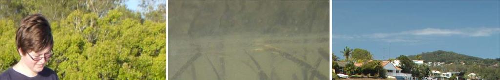
2 First Published 2013 Seagrass Watch HQ, 2013 Copyright protects this publication. Reproduction of this publication for educational or other noncommercial purposes is authorised without prior written permission from the copyright holder provided the source is fully acknowledged. Reproduction of this publication for resale or other commercial purposes is prohibited without prior written permission of the copyright holder. Disclaimer Information contained in this publication is provided as general advice only. For application to specific circumstances, professional advice should be sought. Seagrass Watch HQ has taken all reasonable steps to ensure the information contained in this publication is accurate at the time of the survey. Readers should ensure that they make appropriate enquires to determine whether new information is available on the particular subject matter. The correct citation of this document is McKenzie, LJ & Yoshida, R.L. (2013). Seagrass Watch: Proceedings of a workshop for monitoring seagrass habitats in the Noosa region, South East Queensland. CWA Hall, Tewantin, Queensland, 9 10 March 2013 (Seagrass Watch HQ, Cairns). 50pp. Produced by Seagrass Watch HQ Front cover photos (left to right): monitoring Keyser channel (Feb13) by Maree Cliff; Zostera capricorni underwater by Rudi Yoshida; and Zostera meadow Keyser Island (Nov13) by Len McKenzie. Enquires should be directed to: Len McKenzie Seagrass Watch Program Leader Seagrass Watch HQ TropWATER (James Cook University) PO Box 6811 Cairns QLD 4870 AUSTRALIA
3 Table of Contents OVERVIEW...5 WORKSHOP LEADERS...7 AGENDA - LEVEL 1 (BASIC)...8 SATURDAY 9 TH MARCH 2013 (CWA HALL, TEWANTIN)... 8 SUNDAY 10 TH MARCH 2013 (KEYSER ISLAND)... 8 BACKGROUND 9 INTERESTING FACTS:...17 SEAGRASS IN THE NOOSA REGION OF SOUTH EAST QUEENSLAND...19 A GUIDE TO THE IDENTIFICATION OF SOUTH EAST QUEENSLAND S SEAGRASSES..21 PARTS OF A SEAGRASS PLANT...23 MONITORING A SEAGRASS MEADOW...25 MONITORING SEAGRASS SEAGRASS-WATCH EACH SAMPLING EVENT AT COMPLETION OF MONITORING HOW TO USE A COMPASS...33 MAKING A HERBARIUM PRESS SPECIMEN...36 COLLECTION PRESSING HERBARIA UNDERSTANDING SEDIMENT...39 MANAGING SEAGRASS RESOURCES...41 THREATS TO SEAGRASS HABITATS MANAGEMENT REFERENCES44 3

4 CWA Hall, 123 Poinciana Avenue, Tewantin Telephone:
5 Overview Seagrass Watch is a participatory monitoring program developed in 1998 to provide an early warning of coastal ecological decline. Anyone can participate in Seagrass Watch, as it responds to local needs. Program participants include scientists, rangers and volunteers (e.g., local residents, indigenous groups, tertiary institutions, non government organisations). Seagrass Watch is a monitoring program that brings people together for seagrass conservation. Participants range in ages from 18 to 68 and represent a diverse cross section of the community, including tradespeople, engineers, school teachers, fishers, divers, retirees, high school and university students, biologists and ecologists. Many are involved with local environmental groups and have a keen interest in conservation and environmental issues. Seagrass Watch is a global scientific, non destructive, seagrass assessment and monitoring program. It identifies areas important for seagrass species diversity and conservation. The information collected can be used to assist the management of coastal environments and to prevent significant areas and species being lost. Monitoring seagrass resources is important for two reasons: it is a valuable tool for improving management practices; and it allows us to know whether resource status and condition is stable, improving or declining. Successful management of coastal environments (including seagrass resources) requires regular monitoring of the status and condition of natural resources. Early detection of change allows coastal management agencies to adjust their management practices and/or take remedial action sooner for more successful results. Monitoring is important in improving our understanding of seagrass resources and to coastal management agencies for: exposing coastal environmental problems before they become intractable, developing benchmarks against which performance and effectiveness can be measured, identifying and prioritising future requirements and initiatives, determining the effectiveness of management practices being applied, maintaining consistent records so that comparisons can be made over time, developing within the community a better understanding of coastal issues, developing a better understanding of cause and effect in land/catchment management practices, assisting education and training, and helping to develop links between local communities, schools and government agencies, and assessing new management practices. Seagrass Watch monitoring efforts are vital to assist with tracking global patterns in seagrass health, and assess the human impacts on seagrass meadows, which have the potential to destroy or degrade these coastal ecosystems and decrease their yield of natural resources. Responsive management based on adequate information will help to prevent any further significant areas and species being lost. To protect the valuable seagrass meadows along our coasts, everyone must work together. The goals of the Seagrass Watch program are: to educate the wider community on the importance of seagrass resources to raise awareness of coastal management issues to build the capacity of local stakeholders in the use of standardised scientific methodologies to conduct long term monitoring of seagrass & coastal habitat condition to provide an early warning system of coastal environment changes for management to support conservation measures which ensure the long term resilience of seagrass ecosystems. 5

6 This workshop is coordinated by Maree Cliff and supported by the Noosa Integrated Catchment Association Inc, Caring for our Country, Noosa Biosphere Ltd, and Seagrass Watch HQ (JCU). This workshop is for experienced participants who plan to lead seagrass monitoring at a site/location or conduct seagrass extension activities. As part of the Level 1 workshop we will: 1. study seagrass biology; 2. learn seagrass taxonomy; 3. discuss the present knowledge of seagrass ecology, including importance and threats; 4. gain knowledge of monitoring; 5. learn about the Seagrass Watch program and techniques for monitoring seagrass resources; and 6. become skilled at conducting a Seagrass Watch field monitoring event. The following information is provided as a training guide and a reference for future Seagrass Watch monitoring activities. For further information, please do not hesitate to contact us at Seagrass Watch HQ Centre for Tropical Water & Aquatic Ecosystem Research (TropWATER) James Cook University PO Box 6811 Cairns QLD 4870 AUSTRALIA E mail hq@seagrasswatch.org or visit Photo: Jurgen Freund. 6


7 Workshop leaders Len McKenzie Len is a Principal Researcher with TropWATER (James Cook University) and Seagrass Watch Program Leader. He is also the Task Leader of the Reef Rescue Marine Monitoring Program Intertidal Seagrass Monitoring and project leader for a series of projects involving the assessment and sustainable use of coastal fisheries habitats. Len has over 20 years experience as a researcher on seagrass ecology, assessment and fisheries habitats. This includes experience within Australia and internationally in seagrass research, resource mapping/ assessment and biodiversity. He has provided information on seagrass communities that has been vital in management of seagrass resources of the Great Barrier Reef and at the state, national and international levels. He has also advised on fisheries and coastal resource use issues for managers, fishing organisations, conservation and community groups. Len is a qualified trainer and assessor (TAE40110). Len is also the Secretary of the World Seagrass Association. Current Projects Seagrass Watch Status and mapping of seagrass resources in Queensland Condition, trend and risk in coastal habitats: Seagrass indicators, distribution and thresholds of potential concern Identification of indicators and thresholds of concern for water quality and ecosystem health on a bioregional scale for the Great Barrier Reef Assessment of primary and secondary productivity of tropical seagrass ecosystems Investigations on the macrofauna associated with seagrass meadows Great Barrier Reef Water Quality Protection Plan Reef Rescue Marine Monitoring Program: seagrass Rudi Yoshida Rudi is a Research Assistant with TropWATER (James Cook University). Rudi has over 15 years experience in seagrass related research and monitoring. He is also a core member of Seagrass Watch HQ, and ensures data submitted is managed and QA/QC protocols applied. He is also responsible for maintenance of the Seagrass Watch website. Current Projects Seagrass Watch Great Barrier Reef Water Quality Protection Plan Reef Rescue Marine Monitoring Program: seagrass 7
8 Agenda - Level 1 (basic) Saturday 9 th March 2013 (CWA Hall, Tewantin) Morning (15min) Welcome & Introduction (20min) Seagrass Biology and Identification* (40min) Classroom activity: seagrass Identification (15min) Break (60min) Seagrass Identification continued* (60min) Seagrass Biology 2 and Ecology Afternoon Lunch (30min) Seagrass importance (45min) Seagrass threats* Classroom activity: seagrass importance Classroom activity: seagrass threats (15min) Seagrass monitoring* (15min) Break (60min) Seagrass-Watch: how to sample* Classroom activity: estimating percent cover (45min) Seagrass-Watch: how data is used* (15min) Wrap-up for day Sunday 10 th March 2013 (Keyser Island) (15min) Safety briefing & risk assessment (2hrs) Field exercise: Seagrass-Watch monitoring Where: Keyser Island channel meet at Nancy Cato park be punctual be well rested What to bring: hat, sunscreen (Slip! Slop! Slap!) dive booties or old shoes that can get wet drink/refreshments and energising snack wet weather gear: poncho/raincoat insect repellent polaroid sunglasses (not essential) simple medical kit in case of injuries to yourself change of footwear and clothes enthusiasm You will be walking across a seagrass meadow along a creek bank exposed with the tide, through shallow water Wrap up (on foreshore) check gear feedback Low tide: 0.4m at 1321pm (1.1m, 1620) 8
9 Background Seagrasses are unique flowering plants that have evolved to live in sea water. Seagrasses belong to a group of plants known as angiosperms (flowering plants). Seagrass are marine flowering plants Composite illustration demonstrating morphological features used to distinguish main seagrass taxonomic groups. Various common names are applied to seagrass species, such as turtle grass, eelgrass, tape grass, spoon grass and shoal grass. These names are not consistently applied among countries. Coastal communities would almost certainly recognise the term turtle grass as referring to the shallow subtidal and intertidal seagrasses that turtles are associated with. Like terrestrial (land living) plants, a seagrass can be divided into its veins (lignified conducting tissue that transports food, nutrients and water around the plant), stem, roots (buried in the substrate) and reproductive parts such as flowers and fruits. Algae do not have veins in their leaves nor do they possess roots (anchoring to the surface of the substrate by a holdfast) or produce flowers or seeds. They are called seagrass because most have ribbon like, grassy leaves. There are many different kinds of seagrasses and some do not look like grass at all. Seagrass range from the size of your fingernail to plants with leaves as long as 7 metres. Some of the shapes and sizes of leaves of different species of seagrass include an oval (paddle or clover) shape, a fern shape, a long spaghetti like leaf and a ribbon shape. Species that have a paddle or fern shaped leaf are called Halophila. Ones that have a ribbon shaped leaf are the Cymodocea, Thalassia, Thalassodendron, Halodule and Zostera. Spaghetti like seagrass is called Syringodium. At the base of a leaf is a sheath, which protects young leaves. At the other end of a leaf is the tip, which can be rounded or pointed. The vertical stem, found in some species, is the upright axis of the plant from which leaves arise (attach). The remnants of leaf attachment are seen as scars. Seagrass leaves lack stomata (microscopic pores on the under side of leaves) but have thin cuticle to allow gas and nutrient exchange. They also possess Seagrasses have roots, stems and leaves Seagrass is different to seaweed (algae) as they have internal veins, true roots and produce flowers, fruits and seeds Leaves of different seagrass species can be shaped like a flattened ribbon, look like a fern, round like a clover, or even spaghetti shaped 9
10 large thin walled aerenchyma. The aerenchyma are commonly referred to as veins as they carry water and nutrients throughout the plant (i.e. an internal vascular system). Aerenchyma is specialized tissue having a regular arrangement of air spaces, called lacunae, that both provides buoyancy to the leaves and facilitate gas exchange throughout the plant. Leaves have a very thin cuticle, which allows gas and some nutrient diffusion into them from the surrounding water. Veins can be across the leaf blade or run parallel to the leaf edge. Also within the leaves are chloroplasts, which use the suns light to convert carbon dioxide and water into oxygen and sugar (photosynthesis). The sugar and oxygen are then available for use by other living organisms. The roots and horizontal stems (rhizomes) of seagrass are often buried in sand or mud. They anchor the plant, store carbohydrates and absorb nutrients. Roots can be simple or branching and all have fine hairs to help absorb nutrients. Rhizomes are formed in segments with leaves or vertical stems rising from the joins, called nodes or scars. Sections between the nodes are called internodes. Seagrasses depend upon the growth of rhizomes to increase the area they occupy. This vegetative growth is the most common mode of growth for seagrasses. Although the rhizome mainly runs horizontally, some lateral branches are more or less erect and bear leaves (erect shoots). Sometimes the leaves are on a special type of stalk, called a petiole. Seagrass have veins and air channels in their leaves and stems so they can carry water, food and absorb gases Seagrasses rely on light to convert carbon dioxide and water into oxygen and sugar (photosynthesis) Roots can be simple or branching and all have fine hairs to help absorb nutrients The Roots and Rhizomes of seagrasses are well endowed with aerenchyma and the lacunae are extensive and continuous with leaf tissues. Oxygen transport to the roots creates an oxic environment around the roots, facilitating nutrient uptake. Seagrasses have flowers and pollination systems that are well adapted for pollination by water. Seagrass form tiny flowers, fruits and seeds. Most seagrasses have separate male and female plants. In most species, flowers are small, white and are borne at the base of the leaf clusters. The stamens (male parts) and pistils (female parts) extend above the petals to facilitate pollen release and pollination respectively. Most seagrasses reproduce by pollination while submerged and complete their entire life cycle underwater. Pollination in seagrasses is hydrophilic (aided by water), and can occur by: (i) pollen transported above water surface (e.g., Enhalus); (ii) pollen transported on water surface (e.g., Halodule), or; (iii) pollen transported beneath water surface (e.g., Thalassia). Seagrass pollen grains are elongated into a filamentous shape. The filamentous nature of pollen grains facilitates transport within the water medium, mainly by water currents. Halophila and Thalassia have spherical pollen grains, but they remain joined together in long chains, giving the same effect as having elongated, filamentous pollen grains. After fertilization, the ovary of the female flower develops into a fruit. In seagrasses, fruit development and fruit structure are as diversified as their flowering patterns and floral structures. In general the seeds, ranging in the size from 0.3 to 0.5mm in some Halophila species to more than 1 2 cm in Enhalus, are furnished with a nutrition reserve and sink rather than float. The number of seeds within a fruit also varies from 1 (e.g. Halodule uninervis) up to 25 (e.g. Halophila ovalis). Seagrass pump oxygen into the sediment via their roots Seagrass have flowers, fruits and seeds Pollination occurs in the water Pollen from male seagrass flowers is mainly dispersed to female seagrass flowers by tidal currents Seagrasses are not true grasses Seagrasses are more closely related to lilies 10
11 Seagrass taxonomy Seagrasses are monocotyledons that are not true grasses (true grasses belong to the family Poaceae), but are rather more closely related to the lily family. Seagrasses evolved approximately 100 million years ago from land plants that returned to the sea in a least three separate lineages or families. Thus, seagrasses are not a taxonomically unified group but a biological or ecological group. The evolutionary adaptations required for survival in the marine environment have led to convergence (similarity) in morphology. Worldwide, there are about 12 major divisions, consisting of approximately 60 species (up to 72) of seagrass. The highest concentration of species occurs in the Indo West Pacific region. Over 30 species can be found within Australian waters. The most diverse seagrass communities are in the waters of north eastern Queensland and southern Western Australia. Various common names are applied to seagrass species, such as turtle grass, eelgrass, tape grass, spoon grass and shoal grass. Seagrasses are not seaweeds. Seaweed is the common name for algae. Seagrass evolved 100 million years ago from land plants that returned to the sea There are around 60 species of seagrass found in ocean throughout the world Seagrass requirements for growth Seagrasses require light, nutrients, carbon dioxide, substrate for anchoring, tolerable salinity, temperature and ph to survive. The requirements for a seagrass to be able to exist in the marine environment include: 1. adaptation to life in saline (salty) medium 2. growth when completely submerged 3. anchoring system able to withstand the forces of wave action and tidal currents 4. hydrophilous pollination (pollination aided by water). The need for physiological adaptations to life in sea water is obvious when one considers that seagrasses evolved from land plants, and most land plants are unable to tolerate even small quantities of salt. In contrast to land plants, some seagrasses can tolerate a salinity range from 4 to 65 parts per thousand (2x seawater concentration). Typically, seagrasses grow best in salinities of 35 parts per thousand. Not all species tolerate all salinities equally well, and salinity tolerance may be a factor promoting different species distributions along salinity gradients, e.g., going up estuaries. Some seagrasses can survive in a range of conditions encompassing fresh water, estuarine, marine, or hypersaline (very salty). A limiting factor for many intertidal seagrasses is osmotic impacts resulting from hypersalinity due to evaporation Seagrasses being plants need light for photosynthesis. Light availability is the most dominant overriding factor in seagrass growth. Seagrasses have high minimum light requirements (e.g % on average, 4.4% minimum and 29% maximum depending on species) of surface irradiance) because: (i) they have a high respiratory demand to support a large non photosynthetic biomass (e.g. roots, rhizomes); (ii) they lack certain pigments and therefore can utilise only a restricted spectral range; and (iii) they must regularly oxygenate their root zone to compensate for anoxic sediment. However, light in the intertidal can be in excess of requirements and excess light can cause Seagrasses need plenty of sun and clean water to grow. Seagrasses are physiologically adapted to life in sea water Seagrasses can tolerate a range of salinities. Some species are less tolerant than others Light availability is the most important factor determining seagrass growth Seagrasses require between 10-20% of surface light to grow 11
12 temporary photo damage. UV exposure can also have significant impacts on seagrasses. Temperature influences the rate of growth and the health of plants, particularly at the extremes. As water temperatures increase (up to 38 C) the rate of photorespiration increases reducing the efficiency of photosynthesis at a given CO 2 concentration. The cause of thermal stress at higher temperatures (38 C to 42 C) is the disruption of electron transport activity via inactivation of the oxygen producing enzymes (proteins) of photosystem II. Above these temperatures many proteins are simply destroyed in most plants, resulting in plant death. Temperature also controls the range of ph and dissolved carbon dioxide (CO 2 ) concentrations in the water column; factors critical in plant survival in the marine environment. Seagrasses require inorganic carbon for growth. They uptake inorganic carbon at the leaf surface via two pathways which are species specific. Some species use bicarbonate (HCO 3 ) as an inorganic carbon source (e.g. Halophila ovalis, Cymodocea rotundata, Syringodium isoetifolium and Thalassia), whereas others use enzymes to make CO 2 available as the inorganic carbon source (e.g. Enhalus acoroides, Halodule, Cymodocea serrulata). Seagrasses require two key nutrients, nitrogen and phosphorous, for growth. In the coastal regions, seagrasses appear to be primarily limited by nitrogen and secondarily by phosphorus. The demand for nutrients by seagrasses appears to be seasonally dependent. During the growing season the demand for nutrients is high, however during the senescent season elevated nutrients may become toxic. The availability of nutrients to seagrasses may also be dependent on sediment quality / geochemistry. Bioavailability of nutrients is dependent on particle size and type. For example, clay content influences sediment adsorptive capacity the more clays the greater the absorptive capacity and, calcium carbonate binds phosphorus, limiting its bioavailability. Sediment quality, depth and mobility are important factors for seagrass composition, growth and persistence. Most seagrasses live in sand or mud substrates where their roots and rhizomes anchor the plants to the see floor. Some seagrasses such as Cymodocea spp. prefer deeper sediments while others can tolerate a broad range of sediment depths. Colonising seagrasses such as Halophila spp. and Halodule uninervis are better suited to mobile sediments than larger species. The biogeochemical characteristics of sediment that can affect the nutrient content/binding capacity, organic content and oxygen levels. Seagrasses are unable to grow in sediments of high organic content. Currents and hydrodynamic processes affect almost all biological, geological and chemical processes in seagrass ecosystems at scales from the smallest (physiological and molecular) to the largest (meadow wide). The pollination of seagrass flowers depends on currents and without current flows, vegetative material and seeds will not be transported to new areas, and species will not be exchanged between meadows. Factors such as the photosynthetic rate of seagrasses depend on the thickness of the diffusive boundary layer that is determined by current flow, as is the sedimentation rate. Both influence growth rates of seagrass, survival of seagrass species and overall meadow morphology. Water temperature influences the rate of growth and the health of seagrass Seawater temperatures above 40ºC will stress seagrass. Death occurs at temperatures above 43ºC Seagrass require inorganic carbon for growth Seagrass uptake carbon via two different pathways Seagrass require two key nutrients, nitrogen and phosphorous, for growth Nutrient availability to seagrass is dependent on the type of sediment they grow in Most seagrass live in sand or mud sediments Sediment movement can determine the presence of seagrass species Tidal currents are important for pollination and exchange of gases from the water to the plant 12
13 Where are seagrasses found? Seagrasses are found in ocean throughout the world. They occur in tropical (hot), temperate (cool) and the edge of the artic (freezing) regions. Seagrass are mainly found in bays, estuaries and coastal waters from the midintertidal (shallow) region down to depths of 50 or 60 metres. Most species are found in clear shallow inshore areas between mean sea level and 25 metres depth. Seagrasses survive in the intertidal zone especially in locations sheltered from wave action or where there is pooling of water at low tide, (e.g., reef platforms and tide pools), which protects seagrass from elevated temperatures and drying. Seagrasses inhabit all types of ground (substrates), from mud to rock. The most extensive seagrass meadows occur on soft substrates like sand and mud. The depth range of seagrass is most likely to be controlled at its deepest edge by the availability of light for photosynthesis. Exposure at low tide, wave action and associated turbidity and low salinity from fresh water inflow determines seagrass species survival at the shallow edge. Seagrass plants form small patches that develop into large continuous meadows. These meadows may consist of one or many species: sometimes up to 12 species present within one location. How are seagrasses important to the marine ecosystem? Seagrass communities are one of the most productive and dynamic ecosystems globally. Seagrasses may significantly influence the physical, chemical and biological environments in which they grow by acting as ecological engineers. They provide habitats and nursery grounds for many marine animals and act as substrate stabilisers. Seagrass meadows are highly productive. They have been documented to create habitat complexity compared with unvegetated areas, providing up to 27 times more habitable substrate, as well as providing refuge and food for a range of animals. About 40 times more animals occur in seagrass meadows than on bare sand. One of the most important roles of seagrasses is providing a nursery and shelter area for fish and prawns which are valuable to fisheries. Juveniles of some important species which depend on seagrass meadows include fish such as perch, mullet, whiting, tailor, bream, snappers, emperors and sweetlips. Commercial penaeid prawns such as red spot king, brown tiger, grooved tiger and endeavour also live in seagrass meadows as juveniles. Tropical rock lobsters also live in seagrass meadows as juveniles. Shellfish such as some oysters and pearl shell may be more likely to settle and survive where there is seagrass. Juvenile and adult sandcrabs and flathead are just two species which spend most of their lives in seagrass meadows, where there is not only food but also protection from strong tidal currents and predators. Larger predatory animals such as herons, cormorants, sharks, barramundi, salmon, crocodiles, etc, are also attracted to the seagrass meadows by the schools of forage fish which seek shelter there. Seagrass meadows are a major food source for a number of grazing animals and are considered very productive pastures of the sea. The dugong Seagrass are commonly found in estuaries, shallow coastal locations, and on reef-tops. Seagrass are mainly found in clear shallow inshore areas between mean sea-level and 25 metres depth. The depth that seagrass are found underwater depends on the light availability (water clarity) Seagrass plants form small patches that develop into large meadows Seagrasses are important habitat and feeding grounds for marine organisms. About 40 times more animals occur in seagrass meadows than on bare sand. Seagrasses are important nursery grounds for fish, and they support many human commercial activities. 13
14 (Dugong dugon) and the green turtle (Chelonia mydas) mainly feed on seagrass. An adult green turtle eats about two kilograms of seagrass a day while an adult dugong eats about 28 to 40 kilograms a day. Although dugongs and turtles will feed on any seagrass species within their range, if a range of species is available, they select seagrass species for food which are high nitrogen, high starch and low fibre. For example, the order of seagrass species preference for dugongs is Halophila ovalis > Halodule uninervis > Zostera capricorni. In sub tropical and temperate areas, water birds such as black swans also eat seagrass. Decomposing seagrasses provide food for benthic (bottom dwelling) aquatic life. The decaying leaves are broken down by fungi and bacteria which in turn provide food for other microorganisms such as flagellates and plankton. Microorganisms provide food for the juveniles of many species of marine animals such as fish, crabs, prawns and molluscs. The rhizomes and roots of the grasses bind sediments on the substrate, where nutrients are recycled by microorganisms back into the marine ecosystem. The leaves of the grasses slow water flow, allowing suspended material to settle on the bottom. This increases the amount of light reaching the seagrass meadow and creates a calm habitat for many species. Seagrasses are nutrient sinks, buffering or filtering nutrient and chemical inputs to the marine environment. Seagrasses uptake nitrogen and phosphorus from coastal run off that, in overabundance, can lead to algal blooms that can impair water quality. Dugongs can eat up to 40kg of seagrass per day. Dugongs and turtles select seagrass species for food which are high nitrogen, high starch and low fibre Seagrasses also contribute to the productivity of ecosystems via the detrital food pathway Seagrass binds sediments and help prevent erosion Seagrasses slow water flow and increase water clarity Interactions with mangroves and coral reefs Tropical seagrasses are important in their interactions with mangroves and coral reefs. All these systems exert a stabilizing effect on the environment, resulting in important physical and biological support for the other communities). Barrier reefs protect coastlines, and the lagoon formed between the reef and the mainland is protected from waves, allowing mangrove and seagrass communities to develop. Seagrasses trap sediment and slow water movement, causing suspended sediment to fall out. This trapping of sediment benefits coral by reducing sediment loads in the water. Mangroves trap sediment from the land, reducing the chance of seagrasses and corals being smothered. Sediment banks accumulated by seagrasses may eventually form substrate that can be colonized by mangroves. All three communities trap and hold nutrients from being dispersed and lost into the surrounding oceanic waters. Seagrass help remove harmful nutrient and sediment pollution from coastal waters Seagrasses, mangroves and coral reef interact, providing physical and biological support for other communities Valuation of seagrasses The valuation of ecosystem services is a very controversial topic in today's literature. Ecosystem Services are the processes by which the environment produces resources that we often take for granted. For seagrasses it is services such as clean water, preventing erosion, and habitat for fisheries. The economic values of seagrass meadows are very large, although not always easy to quantify. Seagrass meadows are rated the 3rd most valuable ecosystem globally (on a per hectare basis), only preceded by estuaries and wetlands. The average global value of seagrasses for their nutrient cycling services and the raw product they provide has been estimated at 1994 US$ 19,004 ha 1 yr 1. Seagrass meadows are rated the 3rd most valuable ecosystem globally (more valuable than mangroves or coral reefs) 14
15 What causes seagrass areas to change? Tropical seagrass meadows vary seasonally and between years, and the potential for widespread seagrass loss has been well documented. Factors which affect the distribution of seagrass meadows are sunlight and nutrient levels, water depth, turbidity, salinity, temperature, current and wave action. Seagrasses respond to natural variations in light availability, nutrient and trace element (iron) availability, grazing pressure, disease, weather patterns, and episodic floods and cyclones. The dynamic nature of seagrass meadows in response to natural environmental variation complicates the identification of changes caused by humans. What threatens seagrass? Seagrass meadows can be easily damaged. Approximately 58% of seagrass meadows globally, have lost part of their distribution. According to reports, the documented losses in seagrass meadows globally since 1980 are equivalent to two football fields per hour. Some losses are natural due to storms and herbivores, however most losses are the result of human activities. Human pollution has contributed most to seagrass declines around the world. The most widespread and pervasive cause of seagrass decline is a reduction in available light. Processes that reduce light penetration to seagrasses include pulsed turbidity events during floods, enhanced suspended sediment loads and elevated nutrient concentrations. Poor farming practices can result in excess sediments and fertilizers washing down creeks to the sea. Sewage discharge and stormwater runoff from urban development can elevate nutrients in coastal areas. Boating activity may also stir up sediment, reducing light levels. Phytoplankton and fast growing macroalgae are also better competitors for light than benthic plants and their biomass can shade seagrasses during progressive eutrophication. Oil and trace metal contamination can exert direct toxic effects on some seagrass species. Seagrasses are able to bioaccumulate the trace metals and this can have ramifications for grazers such as dugongs. People can also physically damage or destroy seagrass. Coastal development for boat marinas, shipping ports and housing generally occurs on the coast in areas which are sheltered and seagrass like to grow. Seagrass meadows are either removed or buried by these activities. Coastal developments can also cause changes in water movement. Dredging boat channels to provide access to these developments not only physically removes plants, but can make the water muddy and dump sediment on seagrass. Litter and rubbish can also wash into the sea if not properly disposed. Rubbish can physically and chemically damage seagrass meadows and the animals that live within them. Boating and fishing activities can physically impact or destroy seagrasses. Boat anchors and their chains can dig into seagrass. Propellers can cut into seagrass meadows and unstabilise the rhizome mat. Storms can further exacerbate the damage by the physical force of waves and currents ripping up large sections of the rhizome mat. Uncontrolled digging for bait worm can also physically damage seagrasses and some introduced marine pests and pathogens also have the potential to damage seagrass meadows. Seagrasses can change due to both natural and human impacts People can damage or destroy seagrass by pollution (sewage, oil spills and coastal runoff) and physical destruction (dredging, bait & clam digging, boat propellers and anchors/moorings). Poor farming practices can result in runoff which can damage seagrass by elevating nutrients, reducing available light and releasing herbicides. Coastal development can have a major impact on seagrass meadows 15

16 One of the other significant impacts to seagrass is climate change. The major vulnerability of seagrass to climate change is loss of seagrass in the coastal zone, particularly near river mouths and in shallow areas. The greatest impact is expected to result from elevated temperatures, particularly in shallower habitats where seagrasses grow (e.g., effecting distribution and reproduction). In addition, reduced light penetration from sediment deposition and resuspension are expected due to more intensive cyclones/hurricanes and elevated flooding frequency and amplitude. This will result in even greater seagrass losses, and changes in species composition are expected to occur particularly in relation to disturbance and recolonisation. Following such events, a shift to more ephemeral species and those with lower minimum light requirements is expected. Climate change can threaten intertidal seagrass by increased seawater temperature and greater physical disturbance from storms Please note: citations have been removed for ease of reading. Please see References & Further Reading for source/citations on scientific facts. Notes: 16
17 Interesting facts: Over a billion people live within 50 km of a seagrass meadow. Millions of people obtain their protein from animals that live in seagrasses. The estimated global coverage of seagrass is between 300,000 and 600,000 square kilometres. A hectare of seagrass absorbs 1.2 kilograms of nutrients per year, equivalent to the treated effluent from 200 people. In northern Australia, whole seagrass meadows are able to completely replace their leaves (turnover) in around 14 days during the growing season. A hectare of seagrass sequesters 830 kilograms of carbon per year, equivalent to the CO 2 emissions from an automobile travelling 3,350 km. One square metre of seagrass can produce up to 10 litres of oxygen per day In northern Australia, the primary productivity of seagrass meadows is higher than a mangrove forest, a terrestrial forest or grassland. Seagrasses occupy only 0.1% of the seafloor, yet are responsible for 12% of the organic carbon buried in the ocean, which helps reduce greenhouse gases. The only endangered marine plant is a species of seagrass (Halophila johnsonii in Florida). There is a single clone of seagrass that is over 6,000 years old (Posidonia oceanica in the Mediterranean Sea). It is possibly the world s oldest plant! The deepest growing seagrass (Halophila decipiens), 86 metres, was reported from Cargados Carajos Shoals in the Indian Ocean northeast of Mauritius. Seagrass produce the longest pollen grains on the planet. Some intertidal species of seagrasses can lose up to 50% per cent of their water content and still survive. Did you know that Australia has the highest number of seagrass species of any continent in the world? In Alaska, seagrasses remain frozen and in a dormant state over winter and do not start to grow again until the thaw. The longest known seagrass 7.3 metres in length has been reported from Funakoshi Bay, Japan. 40,000 seeds of Halodule uninervis have been found in 1 square metre of mudflat. In Florida, 80% of the above ground seagrass biomass is consumed by parrot fish. The anchor and chain from one cruise boat can destroy an area of seagrass the size of a football field! 17
18 Notes: 18
19 Seagrass in the Noosa region of South East Queensland The South East Queensland (SEQ)region extends from Noosa in the north to Coolangatta in the south. SEQ is one of Queensland's most important natural, recreational, cultural and economic resources. Seagrasses are a major component of the SEQ marine ecosystems and their contribution to the total primary carbon production (estimated at 105 tonnes of carbon per day (QLD Museum 1998)) is critical to regionally important dugong (Marsh and Lawler 2001) and turtle populations, and productive fisheries (Coles et al. 2003). Coastal meadows are important nursery habitat to juvenile fish and prawns (Williams 1997; Coles et al.1993; Blaber 1980; Beumer et al. 1997; Zeller 1998; Masel & Smallwood 2000). The seagrass also provide habitat for migratory wading birds and food for black swans. Extensive seagrass meadows occur both on intertidal mudflats and subtidal areas. Eight seagrass species occur in the SEQ region (Cymodocea serrulata, Halophila decipiens, Halophila minor, Halophila ovalis, Halophila spinulosa, Halodule uninervis, Syringodium isoetifolium and Zostera muelleri subsp. capricorni (aka Zostera capricorni)), with Zostera capricorni and Halophila ovalis the most common, and Halophila minor the rarest (Phillips et al. 2008); although H. minor taxonomy remains under review (see Waycott et al. 2004). Seagrass communities in SEQ have been mapped several times over the past 35 years to varying degrees and accuracies. Seagrass distribution throughout the region is most likely influenced by shelter, sediment characteristics, water turbidity and tidal exposure. The most extensive seagrass meadows in the SEQ region occur in the intertidal zone. Large seagrass meadows occur in areas of wide intertidal flats while small but dense seagrass meadows are found in association with narrow or confined channels. Seagrass do not occur on exposed oceanic shores in the region, but do occur in small intertidal areas within some rivers and creeks flowing directly into the ocean. Between August 1987 and December 1987 a detailed survey documented the broad extent of seagrass distribution in SEQ (Hyland et al. 1989). Hyland et al. (1989) identified seven species of seagrass, and estimated approximately 14,170 ha of seagrass meadows (light to dense) and 12,500 ha of sparse or patchy seagrass areas between Coolangatta and Noosa. In August 1987, approximately 48 ha of seagrass meadows were mapped in estuaries of the Sunshine Coast (Hyland et al. 1989). The maps from the surveys estimate 1188 ±409 hectares of seagrass meadows between Noosa and Caloundra (Hyland et al. 1989), however, this figure is an over estimate, as the isolated patches within Lakes Cooroibah, Doonella and Weyba were represented in the seagrass distribution maps as large contiguous areas because mapping individual patches was not possible. Only two seagrass species have been reported from the Noosa region: Zostera muelleri subsp. capricorni and Halophila ovalis. The only mapping of seagrass in the Noosa River region since 1987, was in 2007 via remote sensing for an undergraduate project (King 2008), however no estimate of area is available. SEAGRASS-WATCH IN THE NOOSA REGION To provide an early warning of change, long term monitoring has been established on the Noosa River as part of the Seagrass Watch, global seagrass assessment and monitoring program ( McKenzie et al. 2000). Establishing a network of monitoring sites on the Noosa region provides valuable information on temporal trends in the 19


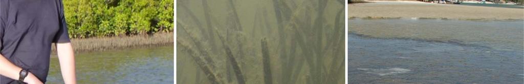
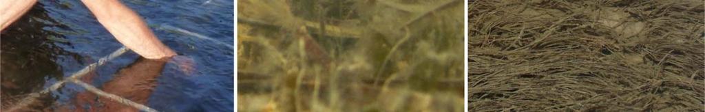
20 health status of seagrass meadows in the region and provides a tool for decision makers in adopting protective measures. It encourages local communities to become involved in seagrass management and protection. Working with both scientists and local stakeholders, this approach is designed to draw attention to the many local anthropogenic impacts on seagrass meadows which degrade coastal ecosystems and decrease their yield of natural resources. Seagrass-Watch monitoring at Noosa: left - Keyser channel, Feb 2013 (photo courtesy Maree Cliff) and right Weyba Creek, 2006 (photo courtesy Kris Boody) Monitoring sites are located at Makepeace Island; Goat Island; Lake Doonella; Keyser Island; and Weyba Creek. Sites were selected based on seagrass density and distribution in the Noosa River, as observed by aerial photography. Areas with low, medium and high impact from recreational and other anthropogenic influences were considered during selection of the monitoring sites. For more information, visit 20
 A guide to tropical seagrasses in the Indo-West Pacific. (James Cook University Townsville) 72pp.")


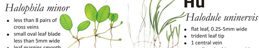
21 A guide to the identification of South East Queensland s Seagrasses Adapted from Waycott, M, McMahon, K, Mellors, J., Calladine, A., and Kleine, D (2004) A guide to tropical seagrasses in the Indo-West Pacific. (James Cook University Townsville) 72pp. Leaves cylindrical Syringodium isoetifolium leaves taper to a point leaves contain air cavities inflorescence a cyme leaves 7-30cm long Leaves oval to oblong obvious vertical stem with more than 2 leaves Halophila spinulosa leaves arranged opposite in pairs leaf margin serrated shoots can be up to 15cm long pairs of leaves per shoot leaf 15-20mm long and 3-5mm wide leaves with petioles, in pairs Halophila ovalis cross veins 8 or more pairs leaf margins smooth no leaf hairs leaf 5-20mm long separate male & female plants Halophila decipiens leaf margins serrated 6-8 cross vein pairs fine hairs on both sides of leaf blade leaves are usually longer than wide Halophila minor oval leaf less than 5mm wide less than 8 pairs of cross veins leaf margins smooth no leaf hairs separate male & female plants 21

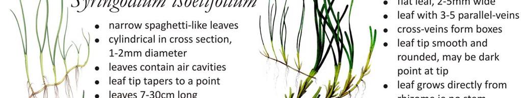
22 Leaves strap-like Leaves can arise from vertical stem Cymodocea serrulata leaf tip rounded with serrated edge leaf sheath broadly flat and triangular, not fibrous leaf sheath scars not continuous around upright stem straplike Halodule uninervis leaf tip tri-dentate or pointed, not rounded leaf with 3 distinct parallel- veins, sheaths fibrous narrow leaf blades mm wide rhizome usually pale ivory, with small black fibres at the nodes Leaves always arise directly from rhizome Zostera muelleri subsp. capricorni leaf with 3-5 parallel-veins cross-veins form boxes leaf tip smooth and rounded, may be dark point at tip rhizome usually brown or yellow in younger parts prophyllum present, i.e. a single leaf originating from the rhizome instead of from the vertical, leaf bearing shoot. 22


23 Parts of a seagrass plant Leaf Tip Can be rounded or pointed. Tips are easily damaged or cropped, so young leaves are best to observe. Veins Edges Sheath Attachment Used by the plant to transport water, nutrients and photosynthetic products. The pattern, direction and placement of veins in the leaf blade are used for Identification. cross vein: perpendicular to the length of the leaf parallel vein: along the length of the leaf mid vein: prominent central vein Intramarginal vein: around inside edge of leaf The edges of the leaf can be either serrated, smooth or inrolled A modification of the leaf base that protects the newly developing tissue. The sheath can entirely circle the vertical stem or rhizome (continuous) or not (non continuous); fully or partly cover the developing leaves and be flattened or rounded. Once the leaf has died, persistent sheaths may remain as fibres or bristles. The leaf can attach directly to the rhizome, where the base of the leaf clasps the rhizome, or from a vertical stem or stalk (petiole) e.g. Halophila ovalis. rounded pointed cross parallel mid intramarginal serrated smooth inrolled clean & flattened fibrous 23
 or open (do not entirely circle the vertical stem). Rhizome The horizontal axis of the seagrass plant, usually in sediment.")

24 Stem The vertical stem, found in some species, is the upright axis of the plant from which leaves arise (attach). The remnants of leaf attachment are seen as scars. Scars can be closed (entirely circle the vertical stem) or open (do not entirely circle the vertical stem). Rhizome The horizontal axis of the seagrass plant, usually in sediment. It is formed in segments, with leaves or vertical stem arising from the joins of the segments, the nodes. Sections between the nodes are called internodes. Rhizomes can be fragile, thick and starchy or feel almost woody and may have scars where leaves were attached. Root Underground tissues that grow from the node, important for nutrient uptake and stabilisation of plants. The size and thickness of roots and presence of root hairs (very fine projections) are used for identification. Some roots are simple or cordlike, others may be branching, depending on seagrass species. Notes: 24
25 Monitoring a seagrass meadow Monitoring is the repeated observation of a system, usually to detect change. It is an integrated activity to evaluate the condition of the physical, chemical and biological character of the environment. Environment monitoring programs provide coastal managers with information and assist them to make decisions with greater confidence. Environmental monitoring programs are ideally designed to: quantify the causes of change; examine and assess acceptable ranges of change for the particular site; and to measure levels of impacts. Common drivers (reasons) for monitoring include: community interest; government policies such as Coastal Strategies and Plans, Oceans Policy, State of the Environment Reporting (SoE), Water Quality guidelines or Best Practice Guidelines; and Government Legislation (e.g., Fish Habitat Protection). Users of the monitoring program information/results are diverse, including for example: the general public, environmental regulators legislators, resource managers and scientists. There are a number of issues to consider when implementing a monitoring program, including: ensure the protocols used have explicit objectives; clearly identified responsibilities of the partners (e.g. Gov agencies, consultants, community groups); a clear and defensible rationale for using the parameters that are measures (e.g. physico/chemico, biological indicators); to have a baseline (first) assessment / measure against which subsequent changes can be measured/compared; knowledge of spatial and temporal variation prior to designing the program (i.e. pilot study); clearly defined field protocols; data management procedures, ensure the level of change and accuracy of the detection is appropriate (as will vary according to the methodology); selection of statistical tools; and a mechanism to reduce and manage errors (i.e. QA/QC program). Appropriate Quality Assurance/Quality Control (QA/QC) procedures are an integral component of all aspects of sample collection and analysis in monitoring programs. This includes participation in relevant inter laboratory studies, proficiency testing, and the use of standard reference materials. Monitoring programs often include the following guidelines for implementation by data collectors and reporters: appropriate methods must be in place to ensure consistency in field procedures to produce robust, repeatable and comparable results including consideration of sampling locations, replication and frequency; all methods used must be fit for purpose and suited to a range of conditions; appropriate accreditation of participating laboratories or provision of standard laboratory protocols to demonstrate that appropriate laboratory QA/QC procedures are in place for sample handling and analysis; participation in inter laboratory performance testing trials and regular exchange of replicate samples between laboratories; rigorous procedures to ensure chain of custody and tracking of samples; appropriate standards and procedures for data management and storage; and a process to ensure data collectors are aware of any errors and provide an opportunity to clarify or correct data. 25
26 Monitoring seagrass Seagrasses are often at the downstream end of catchments, receiving runoff from a range of agricultural, urban and industrial land uses. Seagrass communities are generally susceptible to changes in water quality and environmental quality that make them a useful indicator of environmental health. Seagrass make good bioindicators of environmental health because they are: are widely distributed; have an important ecological role; are sessile plants which show measurable and timely responses to external stressors/impacts (rather than relocating to a less stressful environment) and; are integrative of environmental conditions. Several factors are important for the persistence of healthy seagrass meadows, these include: sediment quality and depth; water quality (temperature, salinity, clarity); current and hydrodynamic processes; and species interactions (e.g., epiphytes and grazers). Seagrass generally respond in a typical manner that allows them to be measured and monitored. In reporting on the health of seagrasses it is important to consider the type of factors that can effect growth and survival. Factors include: increased turbidity reduces light penetration through the water, interfering with photosynthesis and limiting the depth range of seagrass; increased nutrient loads encourages algal blooms and epiphytic algae to grow to a point where it smothers or shade seagrasses, thereby reducing photosynthetic capacity; increased sedimentation can smother seagrass or interferes with photosynthesis; herbicides can kill seagrass and some chemicals (e.g., pesticides) can kill associated macrofauna; boating activity (propellers, mooring, anchors) can physically damage seagrass meadows, from shredding leaves to complete removal; storms, floods and wave action can rip out patches of seagrasses. Seagrass-Watch A simple method for monitoring seagrass resources is used in the Seagrass Watch program. This method uses standardised measurements taken from sites established within representative intertidal meadows to monitor seagrass condition. The number and position of sites can be used to investigate natural and anthropogenic impacts. Seagrass Watch is one of the largest seagrass monitoring programs in the world. Since it's genesis in March 1998 in Australia, Seagrass Watch has now expanded internationally to more than 26 countries. Monitoring is currently occurring at over 300 sites. To learn more about the program, visit Seagrass Watch aims to raise awareness on the condition and trend of nearshore seagrass ecosystems and provide an early warning of major coastal environment changes. Participants of Seagrass Watch are generally volunteers from a wide variety of backgrounds who all share the common interest in marine conservation. Most participants are associated with established local community groups, schools, universities & research institutions, government (local & state) or non government organisations. Seagrass Watch integrates with existing education, government, non government and scientific programs to raise community awareness to protect this important marine habitat for the benefit of the community. The program has a strong scientific underpinning with an 26
27 emphasis on consistent data collection, recording and reporting. Seagrass Watch identifies areas important for seagrass species diversity and conservation and the information collected is used to assist the management of coastal environments and to prevent significant areas and species being lost. Seagrass Watch methods were developed to be rigorous, yet relatively simple and easy to use. Each of the parameters used have been carefully chosen with a clear and defensible rationale. The protocols used have explicit objectives and the sampling strategy is prepared using baseline and knowledge of spatial and temporal variation. As the collection of data by a diversity of participants necessitates a high level of training to ensure that the data is of a standard that can be used by management agencies. After 6 9 hours of training, participants can produce reliable data. Training includes both formal and informal approaches. Formal training is conducted by Seagrass Watch HQ for participants 18 years of age and includes formal lectures and on site assessments with a tired level of certification for competency. Formally trained participants are certified to supervise on site monitoring and demonstrate (i.e. informally train) monitoring methods. Informal training is also conducted by local coordinators and/or scientists. Ideally, at least one formally trained volunteer is present at each monitoring event. Evidence of competency is securely filed at Seagrass Watch HQ. Seagrass Watch has an accepted Quality Assurance Quality Control program in place to ensure that the program is producing data of high quality, and that time and resources are not wasted. Seagrass Watch HQ has systems in place to manage the way Seagrass Watch data is collected, organised, documented, evaluated and secured. The Seagrass Watch program collects and collates all data in a standard format. By using simple and easy methods, Seagrass Watch ensures completeness (the comparison between the amounts of valid or useable data originally planned to collect, versus how much was collected). Standard seagrass cover calibration sheets are used to ensure precision (the degree of agreement among repeated measurements of the same characteristic at the same place and the same time) and consistency between observers and across sites at monitoring times to ensure percentage covers are close to a true or standardised value. Other QAQC procedures include the selection of intertidal seagrass sites which are permanently marked with either plastic star pickets or an accurate (±3m) GPS waypoint. Labels identifying the sites and contact details for the program are attached to these pickets. Positions of 0 m and 50 m points for all three transects at a site are also noted using GPS. This ensures that the same site is monitored each event and that data can be compared between periods of time. Ongoing standardisation of observers is achieved by on site refreshers of standard percentage covers by all observers prior to monitoring and through ad hoc comparisons of data returned from duplicate surveys (e.g. either a site or a transect will be repeated by scientist preferably the next day and unknown to volunteers). Any discrepancy in these duplicates is used to identify and subsequently mitigate bias. For the most part however uncertainties in percentage cover or species identification are mitigated in the field via direct communication (as at least one experienced/certified observer is always present), or the collection of voucher specimens (to be checked under microscope and pressed in herbarium) and the use of a digital camera to record images (protocol requires at least 27% of quadrats are photographed) for later identification and discussion. Seagrass Watch HQ has implemented a quality assurance management system to ensure that data collected is organised and stored and able to be used easily. All data (datasheets and photographs) received are entered onto a relational database on a secure server. Receipt of all original data hardcopies is documented and filed within the James Cook University Management System, a formally organised and secure system. Seagrass Watch HQ operates as custodian of data collected from other participants and provides an evaluation and analysis of 27
28 the data for reporting purposes. Access to the IT system and databases is restricted to only authorised personnel. Provision of data to a third party is only on consent of the data owner/principal. Seagrass Watch HQ checks all data for completeness, consistency and accuracy. All data submitted to Seagrass Watch HQ it is first checked from compliancy: legible original datasheets, good quality quadrat photographs (high resolution), voucher specimens (if required) and completed MS Excel spreadsheet. Validation is provided by checking observations against photographic records to ensure consistency of observers and by identification of voucher specimens submitted. In accordance with QA/QC protocols, Seagrass Watch HQ advises observers via an official Data Error Notification of any errors encountered/identified and provides an opportunity for correction/clarification (this may include additional training). Once Seagrass Watch HQ has completed all checks, a field in the Master database identifies data as either passed, quarantined, non compliant or not passed. Non compliant data is used for large scale summary reporting only if the data quality is deemed acceptable, i.e. if it was collected by a Level 1 trained participant, that the scans/copies of datasheets are OK (only if originals are not available), and/or that the quadrat images were acceptable to complete QAQC, etc. If data quality is unacceptable, the data is either not entered into the Master database or remains quarantined/not passed (excluded from analysis & reporting). If predominantly non compliant data is used for detailed analysis and reporting at a site or location/region, it is marked on the outputs with a notice of non compliancy (e.g., site graphs). If officially requested data is non compliant, a note in the metadata advises of non compliancy and includes a caveat to "use with caution". Any data considered unsuitable (e.g. nil response to data notification within thirty days) is quarantined or removed from the database. Seagrass Watch employs a proactive approach to monitoring, involving ongoing training for participants and the continued development of new methods and refinement of existing methods, including location/habitat specific calibration sheets, operation & validation of autonomous temperature and light loggers, etc. Quality data reassures the data users (e.g., coastal management agencies) that they can use the data to make informed decisions with confidence. Seagrass Watch monitoring efforts are vital to assist with tracking global patterns in seagrass health, and assessing human impacts on seagrass meadows, which have the potential to destroy or degrade these coastal ecosystems and decrease their value as a natural resource. Responsive management based on adequate information will help to prevent any further significant areas and species being lost. To protect the valuable seagrass meadows along our coasts, the community, government and researchers have to work together. THE GOALS OF THE PROGRAM ARE: To educate the wider community on the importance of seagrass resources To raise awareness of coastal management issues To build the capacity of local stakeholders in the use of standardised scientific methodologies To conduct long term monitoring of seagrass & coastal habitat condition To provide an early warning system of coastal environment changes for management To support conservation measures which ensure the long term resilience of seagrass ecosystems. 28
29 50m Seagrass-Watch Protocols Source: McKenzie, L.J., Campbell, S.J. & Roder, C.A. (2001) Seagrass-Watch: Manual for Mapping & Monitoring Seagrass Resources by Community (citizen) volunteers. (QFS, NFC, Cairns) 100pp ( Site layout Transect 1 25m Transect 2 25m Quadrat code = site + transect+quadrat Transect e.g., PI1225 = Pigeon Is. site 1, transect 2, 25m quadrat 3 Pre-monitoring preparation Make a Timetable Create a timetable of times of departure and arrival back, and what the objective of the day is and what is to be achieved on the day. Give a copy of this to all volunteers involved in advance so they can make their arrangements to get to the site on time. List on this timetable what the volunteers need to bring. Have a Contact Person Arrange to have a reliable contact person to raise the alert if you and the team are not back at a specified or reasonable time. Safety Assess the risks before monitoring - check weather, tides, time of day, etc. Use your instincts - if you do not feel safe then abandon sampling. Do not put yourself or others at risk. Wear appropriate clothing and footwear. Be sun-smart. Adult supervision is required if children are involved Be aware of dangerous marine animals. Have a first aid kit on site or nearby Take a mobile phone or marine radio Necessary equipment and materials 3x 50metre fibreglass measuring tapes 6x 50cm plastic tent pegs Compass 1x standard (50cm x 50cm) quadrat Magnifying glass 3x Monitoring datasheets Clipboard, pencils & 30 cm ruler Camera & film Quadrat photo labeller Percent cover standard sheet Seagrass identification sheets Each sampling event Within the 50m by 50m site, lay out the three 50 transects parallel to each other, 25m apart and perpendicular to shore (see site layout). Within each of the quadrats placed for sampling, complete the following steps: Step 1. Take a Photograph of the quadrat Photographs are usually taken at the 5m, 25m and 45m quadrats along each transect, or of quadrats of particular interest. First place the photo quadrat labeller beside the quadrat and tape measure with the correct code on it. Take the photograph from an angle as vertical as possible, which includes the entire quadrat frame, quadrat label and tape measure. Avoid having any shadows or patches of reflection off any water in the field of view. Check the photo taken box on datasheet for quadrat. Step 2. Describe sediment composition Dig your fingers into the top centimetre of the substrate and feel the texture. Describe the sediment by noting the grain size in order of dominance (e.g., Sand, Fine sand, Fine sand/mud). Step 3. Describe other features and ID/count of macrofauna Note and count (whole numbers - never use < or > symbols) any features which may be of interest (e.g. gastropods, hermit crabs, turtle feeding) within the comments column.
30 Step 4. Estimate seagrass percent cover Looking down on the quadrat from above, estimate the total percentage of the seabed (substrate) within the quadrat covered by seagrass. Estimate the footprint/shadow provided by the seagrass shoots. Always use the percent cover photo standards (calibration sheets) as your guide, estimating cover as accurate as possible, e.g. 27%, 61% If cover is below 3%, you can count the seagrass shoots and calculate percent cover using the rule of 1 shoot = 0.1% Step 5. Estimate seagrass species composition Identify the species of seagrass within the quadrat and determine the percent contribution of each species (starting with least abundant, total composition must equal 100%) Use seagrass species identification keys provided and use more than 1 feature to identify the species Step 6. Measure seagrass canopy height Measure canopy height (in centimetres) of the dominant strap-leaf species, ignoring the tallest 20%. Measure from the sediment to the leaf tip of 3 shoots, entering all 3 measures onto datasheet Step 7. Estimate algae percent cover Looking down on the quadrat from above, estimate the total percentage of the seabed (substrate) within the quadrat covered by macroalgae (independent of seagrass cover) Macroalgae is not attached to seagrass leaves and may be attached to rocks, shells or may be drift Step 8. Estimate epiphyte percent cover Epiphytes are algae attached to seagrass blades and often give the blade a furry appearance. First estimate how much of an average seagrass leaf surface is covered, and then how many of the leaves in the quadrat are covered. For example, if 20% of the blades are each 50% covered by epiphytes, then quadrat epiphyte cover is 10%. Use the epiphyte matrix to assist you. Do not include epifauna with epiphytes. Epifauna are sessile animals attached to seagrass blades record % cover of epipfauna in the comments or an unused/blank column do not add to epiphyte cover. Step 9. Take a voucher seagrass specimen if required Place seagrass samples in a labelled plastic bag with a little seawater and a waterproof label. Select a representative specimen of the species and ensure that you have all the plant parts including the rhizomes and roots. Collect plants with fruits and flowers structures if possible. Step 10. Move to next quadrat Repeat steps 1 to 8 for the remaining 32 quadrats Step 11. At completion of monitoring Check data sheets are filled in fully. Remove equipment from site (eg non-permanent pegs) At completion of monitoring Step 1. Wash & pack gear Rinse all tapes, pegs and quadrats with freshwater and let them dry. Review supplies for next quarterly sampling and request new materials Store gear for next quarterly sampling Step 2. Press any voucher seagrass specimens if collected The voucher specimen should be pressed as soon as possible after collection. Do not refrigerate longer than 2 days, press the sample as soon as possible. Allow to dry in a dry/warm/dark place for a minimum of two weeks. For best results, replace the newspaper after 2-3 days. Step 3. Submit all data Data can be entered into the MS-Excel file downloadable from completed files to hq@seagrasswatch.org Mail original datasheets, photos and herbarium sheets Seagrass-Watch HQ TropWATER (James Cook University) PO Box 6811 Cairns QLD 4870 AUSTRALIA


31 31
32

, on which is a large red travel arrow. Attached to the base plate is a turnable dial.")

33 How to use a compass Modified from Kjetil Kjernsmo The most important thing you first need to learn before using a compass are the directions North, South, East and West. Look at the figure below and learn how they are. North is the most important. Remember the sun rises in the east and sets in the west. A type of compass often used in Seagrass Watch is an orienteering compass. It has a large rectangular base plate (often of clear rigid plastic), on which is a large red travel arrow. Attached to the base plate is a turnable dial. The turnable dial on the compass is called the Compass housing. On the edge of the compass housing is a scale from 0 to 360. These are the degrees or the azimuth. Also on the housing are the letters N, S, W and E for North, South, West and East. Within the compass housing is a red and black arrow, called the compass needle (on some compasses it might be red and white). The red part of the needle always points towards the earth's magnetic north pole. To find a direction using the compass, you first turn the compass housing until the direction you desire comes exactly in line with the travel arrow, then holding the compass flat, you then turn the whole compass until the compass needle is aligned within the orienting arrow and the red end of the needle points to N (north). 33

 part of the compass needle points to North in the compass housing.")

 with the travel arrow and now head for it.")
34 For example, if you have arrived at your site and want to lay out transect 2 at bearing (compass heading) of 320 degrees, you first turn the compass housing so that 320 on the housing comes exactly in line with where the large direction of travel arrow meets the housing. 320 Hold the compass flat in your hand so that the compass needle can turn freely. Then turn yourself, your hand, the entire compass (make sure the compass housing doesn't turn), until the compass needle is aligned with the orienting arrow lines inside the compass housing. It is extremely important that the red (North) part of the compass needle points to North in the compass housing. If the red points to the South, you would walk off in the exact opposite direction of what you want! A problem can occur if there is a local magnetic attraction. For example, if you are carrying something of iron, it might disturb the arrow. Even a staple in your book might be a problem. Make sure there is nothing of the sort around. There is a possibility for magnetic attractions in the soil as well, "magnetic deviation", but they are rarely seen. If the needle is directly aligned, you should now be facing 320 degrees. When you are sure you've got it right, fix your eye on some special feature on the horizon (e.g., a rock or coral) with the travel arrow and now head for it. If you are directing someone, keep them informed and line them up with hand signals when they reach the 50m mark. 34
35 When standing at the start of transect 2 and you want to find the start of transect 1, you need to change your compass bearing by subtracting 90 from the transect bearing (e.g., in the previous example, = 230). Measure 25m from the start of transect 2, heading 230 degrees, and put in the peg. This is the start of transect 1. Lay out transect 1 using the same procedure as you just completed fro transect 2 (heading 320). To locate the start of transect 3, you need to change your compass bearing by adding 90 from the transect bearing (e.g., in the previous example, = 410, but as only 360 in a compass your bearing will be 50). Measure 25m from the start of transect 2, heading 50 degrees, and put in the peg. This is the start of transect 3. Lay out transect 3 using the same procedure as you just completed for both transects 1 and 2 (heading 320) m m 25m 35
36 Making a herbarium press specimen Herbaria are repositories of preserved and labelled plant specimens, arranged to allow easy access and archival storage. The specimens are typically in the form of herbarium sheets: pressed and dried plants that have been attached to a sheet of heavy paper together with a data label. A herbarium specimen is simple in form and low tech in preparation, yet it preserves a wealth of valuable information. If properly stored, a herbarium specimen will last for centuries without much deterioration. Specimens document the variation in form and geographical range of species. Herbaria also document valuable historical collections, such as "type specimens", the original specimens on which a plant's Latin name is based. Many herbarium specimens record the existence of plants in habitats now developed and lost. COLLECTION PRESSING Before collecting any seagrass specimens, ensure you have the appropriate permits. In the field, collect a handful of representative seagrass shoots, including the leaves, rhizomes and roots. Keep in mind that it is not always possible to get a successful classification if you do not have particular parts such as flowers, fruits, seeds and roots, so try to select shoots which have these features. Ideally, collect plants with growing tips (meristems) as they contain higher concentrations of DNA which could aid genetic identification in the future. Specimens should be pressed as soon as possible after collection. If it is more than 2 hours before you press the specimen, then you should refrigerate to prevent any decomposition. Do not refrigerate longer than 2 days, press the sample as soon as possible. Tools First you will need some clean white cartridge type paper (photocopy paper will suffice) and herbarium sheets (if available). You will also need forceps, scissors/scalpel, a dish of clean fresh water and a herbarium press. It is not difficult to build a home made press, keeping in mind that what must be accomplished is to keep the specimens squeezed between layers of paper (newspapers or blotting paper) until they are totally devoid of the original content of water. The upper and lower parts of the press might be made of heavy cardboard or thick plywood or equivalent material. A more advanced kind of press might be built for an optimal drying of your plants. This press can be made with two wooden boards with screws and nuts placed at each corner: turning the nuts the two boards will come closer pushing together the paper with the plants. This kind of press can be built at home or bought in some art tools stores. Preparation Wash the seagrass specimen in clean fresh water and carefully remove any debris, epiphytes or sediment particles. Arrangement It is very important that the seagrass specimen be arranged so that you can immediately see all the main characters of that particular species; so do not focus only at the aesthetics of the mounted specimen. It is advisable to arrange specimens before being placed in the press as once dried, plant specimens can easily be broken if handled without care. The best manner to place the plants on the mounting sheets is to align them with the right side of the page (or diagonally if space is required) and to have the heaviest parts and specimens at the bottom. Leaves can be folded in larger specimens if a larger press in not available. It is better to leave an empty space at the borders of the mounting sheets; but you can either arrange your specimens (along with the label) in a regular way from page to page, or stagger the specimens 36
 along with information on the date and place of")
37 at different positions on each sheet, so that each group of sheets will have a more equally distributed pressure. Labels Each specimen must have a label on its own sheet, which should include the taxonomic denomination (at least family, genus and species) along with information on the date and place of collection. The name of the collector and of the individual who did the determination should also be added. Use permanent and water resistant ink (black or blue) to write your labels; otherwise a pencil can be used (medium lead). Specimen labels should include: species name (if known) location & site code (if applicable) date collected latitude/longitude water depth % seagrass cover sediment type other seagrass species present name of collector and who identified the specimen comments such as presence of flowers/fruits or ecological notes Place the label on the lower right hand corner of the paper. Drying Place another clean sheet of paper over the specimen and place within several sheets of newspaper. As circulating air is very important to get your specimens dried in a short time, the assemblage of specimen/paper should be placed within two sheets of corrugated cardboard and then into a herbarium press. Corrugated cardboard ensures air can penetrate and speed up the drying process. If no corrugated cardboard is available, keep the filled press size small. Once in the herbarium press, wind down the screws until tight (do not over tighten). If you do not have a press, the specimens can be pressed by putting some heavy object on top, i.e. bricks or large books. It is important that the plants are put under sufficient pressure; otherwise more time will be required to achieve a good desiccation, besides they could be damaged by dampness and moulds. The press should be exposed to a gentle heat source, avoiding excessive heat that will "cook" the specimens. Sometimes it is possible to use the heat from the sun. In this case the presses should be small. If fire is the heat source, keep the press at a safe distance to prevent fire starting on the press. Changing the paper is a very important step. In the first three or four days a paper change should take place every day, then you can leave more time between changes. If you neglect the change of paper the plants will take more time to loose their water content, besides they could be damaged if the paper stays wet for a few days. When changing the paper you must keep the specimens intact and ensure the label travels with the specimen. The minimum time required for complete dying ranges from two to four days or more. Once a specimen has become dry and stiff, it can be mounted and placed into the herbarium. 37
38 Mounting Once the specimen is completely dry, you will need to mount it to herbarium sheets if available or a new clean white cartridge type paper. There are different ways to mount the specimens to the herbarium sheets, such as strapping, gluing, pinning or nothing. We recommend the strapping method using removable adhesive tape (e.g. Magic Tape). The tape pulls off easily, leaves behind no messy residue, and can be pulled up and moved around. To fix the specimen to the mounting paper, lay small strips of tape across a few sturdy parts of the plant (e.g. either end of rhizome or a stem) at a minimal number of points. This method will allow a certain degree of movement for further examinations, but the specimen will not fall from the mounting paper HERBARIA Once the specimen is mounted it can be stored in a dry place or lodged in Herbaria. If you do not have a Herbaria in your region or state (usually located at a University or Government agency), you can submit specimens to Seagrass Watch HQ which maintains a Herbaria as part of the Australia Tropical Herbarium. Alternatively, you can a scanned image of the pressed specimen. Please ensure that the scanned image is no less then 600 dpi and includes the specimen and label. Scanned images can be sent to hq@seagrasswatch.org and will be lodged in the Seagrass Watch Virtual Herbarium The Virtual Herbarium is an electronic gateway to the collections of the Seagrass Watch HQ herbaria. The goals of the Virtual Herbarium are to make specimen data available electronically for use in biodiversity research projects; to reduce transport of actual specimens for projects where digital representations will suffice for study; and to provide a source of reference information for Seagrass Watch participants. 38
39 Understanding sediment Seagrasses, especially structurally large species, affect coastal and reef water quality by trapping sediments and acting as a buffer between catchment inputs and reef communities. Seagrass meadows have the ability to modify the energy regimes of their environments, and help stabilise sediment by trapping and binding the sediment. However, the trapping ability of seagrass is in reality an equilibrium established between deposition/sedimentation and erosion/resuspension. Studies have shown that sediment characteristics are important in determining seagrass growth, germination, survival, and distribution. As part of Seagrass Watch, field descriptions of sediment type collected 0 2 cm below the sediment/water interface are determined by visual and tactile inspection of (wet) samples and constituents (primary descriptors) differentiated according to the Udden Wentworth grade scale. Grain size classes used, based on the Udden Wentworth grade scale of Wentworth (1922). Mud Sand Gravel Fine medium Clay Coarse Clay Very Fine Silt Fine Silt Medium Silt Coarse Silt Very Fine Sand Fine Sand Medium Sand Coarse Sand Very Coarse Sand Granules Pebbles and larger mm mm mm mm mm mm mm mm mm mm mm mm > mm In Seagrass Watch, the primary descriptors relate to the size of the sediment grains: gravel (>2000μm); coarse sand (>500 μm); sand (>250 μm); fine sand (>63 μm); and mud (<63 μm). The sediment Primary Descriptors are written down from left to right in decreasing order of abundance: e.g. Mud/Sand is mud with sand, where mud is determined as the dominant constituent (by volume). mud has a smooth and sticky texture. fine sand fairly smooth texture with some roughness just detectable. Not sticky in nature. sand rough grainy texture, particles clearly distinguishable. coarse sand coarse texture, particles loose. gravel very coarse texture, with some small stones. Sediment type Modifiers are also commonly used, however these are recorded in the comments section. Modifiers include: coral, shell grit, forams, diatoms, etc. The visual/tactile estimation method used in Seagrass Watch is a simple yet relatively accurate measure of the sediment grain size which can be used for quantitative assessments (see McKenzie 2007, 39
 very")
 (0.")

 fine")


40 gravel (>2mm) very coarse sand (1 2 mm) coarse sand (0.5 1 mm) medium sand ( mm) fine sand ( mm) very fine sand ( mm) Notes: 40
Seagrass-Watch. Activity Book. Junior Edition
 Seagrass-Watch Activity Book Junior Edition Sensational Seagrass Seagrass are flowering plants that live in the sea. There are many different kinds of seagrasses and some do not look like grass at all.
Marine Ecosystems. Aquatic Ecosystems Section 2
 Marine Ecosystems Marine ecosystems are located mainly in coastal areas and in the open ocean. Organisms that live in coastal areas adapt to changes in water level and salinity. Organisms that live in
Seagrass-Watch Proceedings of a workshop for monitoring seagrass habitats in South East Queensland QPWS, Moreton Bay Manly Office August 2013 Len
 Seagrass-Watch Proceedings of a workshop for monitoring seagrass habitats in South East Queensland QPWS, Moreton Bay Manly Office August 2013 Len McKenzie & Rudi Yoshida First Published 2013 Seagrass Watch
Habitat Fact Sheets. Rocky habitats are dominated by seaweeds and often mussels, which rely on the rocks for attachment.
 Habitat Fact Sheets Habitats in the Gulf of Maine serve many important roles for the environment and for humans as well. These include: cycling nutrients, filtering pollution, trapping sediments, storing
SALINITY. It's the amount of dissolved salts the water contains.
 AQUATIC ECOSYSTEMS SALINITY The types of organisms in an aquatic ecosystem depend upon the water s Salinity. It's the amount of dissolved salts the water contains. Salinity determines the two main aquatic
CHAPTER 11.1 THE WORLD OCEAN MARINE BIOMES NOTES
 CHAPTER 11.1 THE WORLD OCEAN MARINE BIOMES NOTES 1. The world ocean can be divided into zones both and. The,, and zones that apply to large lakes also apply to the ocean. 2. In addition to the depth zones,
Seagrass-Watch Proceedings of a workshop for monitoring seagrass habitats in the Kimberley region, Western Australia Department of Parks and Wildlife
 Seagrass-Watch Proceedings of a workshop for monitoring seagrass habitats in the Kimberley region, Western Australia Department of Parks and Wildlife (DPaW) - Broome Work Centre Broome, Western Australia
Seagrass-Watch. Len McKenzie
 Seagrass-Watch Proceedings of a Workshop for Mapping and Monitoring Seagrass Habitats in North East Arnhem Land, Northern Territory 18 th 20 th October 2008 Len McKenzie Seagrass-Watch HQ Table of Contents
Examples of estuaries include bays, sounds, salt marshes, mangrove forests, mud flats, swamps, inlets, and sloughs.
 An estuary is a partially enclosed body of water where incoming seawater is mixed with fresh water coming from the land. Examples of estuaries include bays, sounds, salt marshes, mangrove forests, mud
Seagrass Educators Handbook By Len McKenzie (Seagrass-Watch HQ/DPI&F), Feb 2008
, Feb 2008") Seagrass-Watch Seagrass Educators Handbook By Len McKenzie (Seagrass-Watch HQ/DPI&F), Feb 2008 This handbook provides educators with information on what seagrasses are, their plant morphology and anatomy,
Seagrass-Watch Seagrass Educators Handbook By Len McKenzie (Seagrass-Watch HQ/DPI&F), Feb 2008 This handbook provides educators with information on what seagrasses are, their plant morphology and anatomy,
Warm-up # 7 A day 5/17 - B day 5/18 UPDATE YOUR TABLE OF CONTENTS
 Warm-up # 7 A day 5/17 - B day 5/18 UPDATE YOUR TABLE OF CONTENTS Question: List all examples of surface water on Earth. Answer: Rivers and streams, lakes and reservoirs, (ponds) wetlands, estuaries and
Seagrass Surveys in Kampot
 Coastal Annual Forum 23 rd October 2014 Sihanoukville, Cambodia Seagrass Surveys in Kampot Presentation by Louis Bourne INTERNATIONAL UNION FOR CONSERVATION OF NATURE Presentation Overview Location and
Seagrass-Watch. Activity Book
 Seagrass-Watch Activity Book Sensational Seagrass Seagrass is one of the most important plants on earth. Seagrass is the only marine flowering plant. Seagrass is found in oceans throughout the world and
Review of the current impacts of Dredge Spoil Islands and water circulation on adjacent seagrass beds Swansea Flats
 Office of the Lake Macquarie and Catchment Co-ordinator Review of the current impacts of Dredge Spoil Islands and water circulation on adjacent seagrass beds Swansea Flats March 2004 TABLE OF CONTENTS
Seagrasses of the Virgin Islands
 Seagrasses of the Virgin Islands Seagrasses are flowering plants that live underwater. These marine plants resemble the land species of grasses in that they have long blade-like leaves. Seagrasses grow
Oceans Humans both depend on it and threaten it with their activities
 Oceans Humans both depend on it and threaten it with their activities Oceans Water covers nearly ¾ of the Earth s surface More than 50% of the world s population lives within an hour of the coast Oceans
EVALUATING THE EFFECTS OF BIVALVE SHELLFISH AQUACULTURE AND ITS ECOLOGICAL ROLE IN THE ESTUARINE ENVIRONMENT IN THE UNITED STATES
 EVALUATING THE EFFECTS OF BIVALVE SHELLFISH AQUACULTURE AND ITS ECOLOGICAL ROLE IN THE ESTUARINE ENVIRONMENT IN THE UNITED STATES Brett Dumbauld USDA Agricultural Research Service, Hatfield Marine Science
Types of Freshwater Ecosystems. Streams originate from underground water. Rivers form when streams join together. Freshwater Biome
 Definition Streams originate from underground water sources Types of Freshwater Ecosystems Streams Rivers Rivers form when streams join together Freshwater Lakes Ponds Basic Characteristics Directional
Dr. Kim Peyton. (w/ some modifications by Dr. Bruland) University of Hawai i Mānoa
 University of Hawai i Mānoa") The Seagrasses Dr. Kim Peyton (w/ some modifications by Dr. Bruland) University of Hawai i Mānoa Department t of Botany 1 Outline Anatomy Characteristics Taxonomy, systematics, &evolution Distribution
The Seagrasses Dr. Kim Peyton (w/ some modifications by Dr. Bruland) University of Hawai i Mānoa Department t of Botany 1 Outline Anatomy Characteristics Taxonomy, systematics, &evolution Distribution
WHAT ARE ECOSYSTEMS? Dr. V. N. Nayak Professor of Marine Biology (Retd)
") WHAT ARE ECOSYSTEMS? Dr. V. N. Nayak Professor of Marine Biology (Retd) An ECOSYSTEM is an interacting system of plant, animals, and humans and the surrounding environment. An ecosystem contains living
WHAT ARE ECOSYSTEMS? Dr. V. N. Nayak Professor of Marine Biology (Retd) An ECOSYSTEM is an interacting system of plant, animals, and humans and the surrounding environment. An ecosystem contains living
Definitions. The environment is the biological, chemical, physical, and social conditions that surround organisms.
 Marine Ecosystems Definitions An ecosystem is a geographically specified system of organisms (including humans), the environment, and the processes that control its dynamics. The environment is the biological,
5/8/2018. Estuaries are classified by: > Mode of formation e.g. glaciers, deposition, sea level rise. > Patterns of water circulation
 Prepared by Diana Wheat-LBCC Compare and contrast the various types of estuaries, including their origin, size, shape, and general location on earth. Distinguish and describe the different types of habitats
Restoration of Eelgrass to Upper Casco Bay: Feasibility Tests in Hilary A. Neckles US Geological Survey Augusta, ME
 Restoration of Eelgrass to Upper Casco Bay: Feasibility Tests in 2015 Hilary A. Neckles US Geological Survey Augusta, ME hneckles@usgs.gov Robert J. Orth Eelgrass: Zostera marina * marine flowering plant
Seagrasses: Vital Habitat in Texas Estuaries
 Seagrasses: Vital Habitat in Texas Estuaries Cindy Hobson Water Resources Branch Coastal Fisheries Division Texas Parks and Wildlife Department February 17, 2015 Why Care About Seagrass? Sustain coastal
Lecture Benthic Ecology
 Lecture Benthic Ecology Benthos Unlike the drifting plankton and swimming nekton, benthic organisms commonly referred to as benthos live on or near the ocean bottom A benthic habitat may be shallow or
Seagrass-Watch Guidelines for Torres Strait Land & Sea Rangers
 Seagrass-Watch Guidelines for Torres Strait Land & Sea Rangers Port Kennedy Association Hall, Thursday Island 26 th February 2007 Len McKenzie & Jane Mellors Department of Primary Industries & Fisheries,
dugon) ) and Seagrass in Thailand: Present Status and Future Challenges Kanjana Adulyanukosol Sombat Poovachiranon Mickmin Charuchida
 ) and Seagrass in Thailand: Present Status and Future Challenges Kanjana Adulyanukosol Sombat Poovachiranon Mickmin Charuchida") Dugong ( (Dugong dugon) ) and Seagrass in Thailand: Present Status and Future Challenges Kanjana Adulyanukosol Sombat Poovachiranon Mickmin Charuchida Phuket Marine Biological Center (PMBC) Department
Dugong ( (Dugong dugon) ) and Seagrass in Thailand: Present Status and Future Challenges Kanjana Adulyanukosol Sombat Poovachiranon Mickmin Charuchida Phuket Marine Biological Center (PMBC) Department
Sample page. Contents
 Contents Part A: Mangroves and seagrasses 5 A1. What do mangroves look like? 5 A2. Which animals use mangroves for shelter? 7 A3. How do mangroves grow? 8 A4. How do mangroves reproduce? 10 A5. Which animals
Annual Measurement of Solar UVB at a Reef Site Using a Polyphenylene Oxide Dosimeter
 Annual Measurement of Solar UVB at a Reef Site Using a Polyphenylene Oxide Dosimeter Alfio Parisi, Nathan Downs, Peter Schouten parisi@usq.edu.au University of Southern Queensland, Toowoomba, Australia
Refined Designated Uses for the Chesapeake Bay and Tidal Tributaries
 A-1 appendixa Refined Designated Uses for the Chesapeake Bay and Tidal Tributaries BACKGROUND Federal water quality standards regulations establish that states must specify appropriate water uses to be
Overview. What are Corals?
 Overview Coral Reefs extend back over 500 m.y. Grow in tropical seas with normal salinity Support a great variety of plant and animal life Cover less than 0.2% of sea floor Contain about 25% of marine
Florida Seagrass Integrated Mapping and Monitoring Program
 Florida Seagrass Integrated Mapping and Monitoring Program - 2004 The following document is composed of excerpts taken from the 2011 publication, Seagrass Integrated Mapping and Monitoring for the State
Seagrass-Watch Proceedings of Workshops for Monitoring Seagrass Habitats in South East Queensland
 Seagrass-Watch Proceedings of Workshops for Monitoring Seagrass Habitats in South East Queensland Capalaba Baseball Club, Sheldon, Brisbane 24 th November 2007 & Gecko House, Currumbin, Gold Coast 25 th
Coastal areas have become increasingly under threat in recent years. Climate change is having a huge effect on coastal areas, making them much more
 Why are some coastal environments under threat? Coastal areas have become increasingly under threat in recent years. Climate change is having a huge effect on coastal areas, making them much more likely
Biological Oceanography: Benthos
 Biological Oceanography: Benthos Dr Rhian G. Waller MSB 610 rwaller@hawaii.edu x67822 Biological Oceanography: Benthos Benthic Generalizations, Introduction Sediments and Biogeochemistry Deposit Feeding
Oceanic Society Reef Research Team: Nicole Crane, Avigdor Abelson, Peter Nelson, Giacomo Bernardi, Michelle Paddack, Kate Crosman
 The coral reef of Tamil (Yap, FSM): Preliminary ecological assessment of reef state and fish assemblages, and potential of conservation for sustainable use Report compiled by vigdor belson, Peter Nelson
UNIVERSITY OF CAMBRIDGE INTERNATIONAL EXAMINATIONS General Certificate of Education Advanced Subsidiary Level and Advanced Level
 UNIVERSITY OF CAMBRIDGE INTERNATIONAL EXAMINATIONS General Certificate of Education Advanced Subsidiary Level and Advanced Level *2677524077* MARINE SCIENCE 9693/03 Structured Questions May/June 2013 Paper
Texas Water Resources Institute
 Texas Water Resources Institute November/December 1982 Volume 8 No. 6 A Precise Environment By Lou Ellen Ruesink, Editor, Texas Water Resources Aquarium enthusiasts know just how particular fish are about
INTRODUCTION SEAS AND OCEANS: A PRECIOUS RESOURCE KEY FACTS
 6 ~ SEAS FOR LIFE INTRODUCTION SEAS AND OCEANS: A PRECIOUS RESOURCE We all benefit from our seas and oceans. In addition to the more traditional uses like transport, fishing, aquaculture, tourism and recreation,
Today: Coastal Issues and Estuaries
 Today: Coastal Issues and Estuaries Coastal issues Human effect on coastlines What is an estuary Why are they so important? Circulation of water in estuary Environmental issues Coastal Issues: Problem
Marine Environments. Copyright 2011 LessonSnips
 Marine Environments I must go down to the seas again, for the call of the running tide Is a wild call and a clear call that may not be denied Excerpt from a poem by John Masefield Continents and islands
Marine Conservation and Research Expedition Training, Examination and Certification Summary
 Marine Conservation and Research Expedition Training, Examination and Certification Summary Introduction This document summarizes the current training schedule and materials being used at the two Marine
Lesson 10: Oyster Reefs and Their Inhabitants
 Lesson 10: Oyster Reefs and Their Inhabitants Focus Question: What animals use oyster reefs for habitats? Objective: observe properties of animals found within a bag of oysters; Infer about the quality
LK Increasing knowledge on sea grass habitats and dugong distribution at selected sites in North Western Sri Lanka Project progress July2016
 LK6-2132 Increasing knowledge on sea grass habitats and dugong distribution at selected sites in North Western Sri Lanka Project progress July2016 ORCA Ocean Resources Conservation Association This is
Fighting for Life in French Creek
 Fighting for Life in French Creek Created By: An original Creek Connections activity created by David Hall, Creek Connections staff. Creek Connections, Allegheny College, Meadville, Pennsylvania, 16335
Questions # 4 7 refer to Figure # 2 (page 321, Fig )
") Shoreline Community College OCEANOGRAPHY 101 Fall 2006 Sample Exam # 3 Instructor: Linda Khandro Questions # 1 3 refer to Figure # 1 (page 284, Fig 11.7) 1. At which position is the moon in its new moon
Shoreline Community College OCEANOGRAPHY 101 Fall 2006 Sample Exam # 3 Instructor: Linda Khandro Questions # 1 3 refer to Figure # 1 (page 284, Fig 11.7) 1. At which position is the moon in its new moon
Seagrass: Global Conservation Challenges
 Seagrass: Global Conservation Challenges Len McKenzie 1 & Richard Unsworth 2 1 James Cook University, Cairns, Queensland, Australia 2 Swansea University, Swansea, Wales, United Kingdom photo courtesy Ria
Secret Gardens under the Sea: What. They Important? SEA PLEASE KEEP OFF GRASS
 the Earth and its Resources Published: 01 February 2018 doi:10.3389/frym.2018.00002 SEA PLEASE KEEP OFF GRASS Secret Gardens under the Sea: What Are and Why Are They Important? Leanne Claire Cullen-Unsworth
Dr. Prakash N. Mesta
 Coastal Wetland Monitoring Dr. Prakash N. Mesta prakashhonavar@gmail.com Coastal Ecosystem is diverse in nature Most of the world human population p settled in Coastal region. Cities & Industries established
The Maritime Law Association of Australia and New Zealand
 The Maritime Law Association of Australia and New Zealand Protecting the Environment and Promoting Safe Navigation: Australia s System of Pilotage in the Torres Strait Adam McCarthy Assistant Secretary
Fish Texas AQUATIC ECOSYSTEMS
 27 Additionally, healthy aquatic communities in Texas rivers, reservoirs and estuaries provide unparalleled recreational opportunities to millions of Texans. Our fresh and saltwater environments vary from
Eelgrass Survey PARADISE CAY BELVEDERE, MARIN COUNTY CALIFORNIA. Prepared For:
 Eelgrass Survey PARADISE CAY BELVEDERE, MARIN COUNTY CALIFORNIA Prepared For: Radford (Skid) Hall, Ph.D. Land Planning and Permitting Consultant 500 Airport Blvd., Suite 350 Burlingame, CA 94010 (650)
Cambridge International Examinations Cambridge International Advanced Subsidiary and Advanced Level
 Cambridge International Examinations Cambridge International Advanced Subsidiary and Advanced Level *9180775193* MARINE SCIENCE 9693/03 Paper 3 A2 Structured Questions May/June 2017 1 hour 30 minutes Candidates
Great Barrier Reef: Bleaching 'kills 35% of area's coral' 8 hours ago From the section Australia
 Great Barrier Reef: Bleaching 'kills 35% of area's coral' 8 hours ago From the section Australia Image copyright AFP Image caption The recovery of coral cover is expected to take a decade or longer, scientists
1. Distribute the activity sheet, and allow 20 minutes for the first use.
 A LOCAL WAY OF LEARNING Title: MISSING MANGROVE MESSAGE Author: Eulalie R. Rivera Elementary School Environmental Education Team Grade Level: 4-6 Concepts: 2.Ecosystem 6.Resources 9.Change Disciplines:
Green crabs: invaders in the Great Marsh Featured scientist: Alyssa Novak from the Center for Coastal Studies/Boston University
 Name Green crabs: invaders in the Great Marsh Featured scientist: Alyssa Novak from the Center for Coastal Studies/Boston University Research Background: Marshes are areas along the coast that flood with
Chesil Beach, Dorset UK High energy, shingle coastline. Brighton Beach, Sussex UK Pebble beach
 Beaches: Depositional landform Extends from the highest high tide to the lowest low tide. Very important temporary store in coastal system. Accretion: sediment returning to the visible portion of a beach
Context Most US West Coast open coast estuaries have: INTERTIDAL AQUACULTURE AS HABITAT IN PACIFIC NORTHWEST COASTAL ESTUARIES: CONSIDERING SCALE
 INTERTIDAL AQUACULTURE AS HABITAT IN PACIFIC NORTHWEST COASTAL ESTUARIES: CONSIDERING SCALE Brett Dumbauld USDA Agricultural Research Service Context Most US West Coast open coast estuaries have: Broad
Indian River Lagoon: Lessons, Challenges and Opportunities
 Indian River Lagoon: Lessons, Challenges and Opportunities Upper Chain of Lakes Lake Kissimmee Kissimmee River Indian River Lagoon Caloosahatchee Estuary Lake Okeechobee St. Lucie Estuary Mark Perry, Executive
THE SEAGRASS LANDSCAPE OF BUNDAS MARINE PROTECTED AREA, BARANGAY BAGUMBAYAN, LUPON, DAVAO ORIENTAL, PHILIPPINES
 THE SEAGRASS LANDSCAPE OF BUNDAS MARINE PROTECTED AREA, BARANGAY BAGUMBAYAN, LUPON, DAVAO ORIENTAL, PHILIPPINES Presented by: Cirilo O. Ybaňez Jr. 1, Kris Vallerie A. Oñate 2 Davao Oriental of State College
For Creative Minds. Salt Marsh Plants and Animals
 For Creative Minds The For Creative Minds educational section may be photocopied or printed from our website by the owner of this book for educational, non-commercial uses. Cross-curricular teaching activities,
Protect Our Reefs Grant Interim Report (October 1, 2008 March 31, 2009) Principal investigators: Donald C. Behringer and Mark J.
 Principal investigators: Donald C. Behringer and Mark J.") Investigating the role of the spotted spiny lobster (Panulirus guttatus) in the recovery of the long spined sea urchin (Diadema antillarum) on the coral reefs of the Florida Keys Protect Our Reefs Grant
Investigating the role of the spotted spiny lobster (Panulirus guttatus) in the recovery of the long spined sea urchin (Diadema antillarum) on the coral reefs of the Florida Keys Protect Our Reefs Grant
;DG:HIH Plankton
 or coral reefs near the shore of the ocean it is easy for us to see the various parts of an ecosystem, especially because the near-shore ecosystems tend to be particularly productive and have a high level
Eastern Shore Islands Area of Interest Community Newsletter
 Eastern Shore Islands Area of Interest Community Newsletter Fall 2018 1ỊNTRODUCTION In addition to information on our Fisheries and Oceans Canada (DFO) website, we have now created a seasonal, community
MARSH DEGRADATION AT THE MOUTH OF MOORE CREEK
 MARSH DEGRADATION AT THE MOUTH OF MOORE CREEK Hunter Winstanley, Department of Earth Sciences, University of South Alabama, Mobile, AL 36688. E-Mail: hcw501@jaguar1.usouthal.edu. Moore Creek is located
Canon Envirothon Wildlife Curriculum Guidelines
 Canon Envirothon Wildlife Curriculum Guidelines Please note: the resources in this document are web links and require an internet connection to access them. Key Point 1: Knowledge of Wild Birds, Mammals
Cambridge International Examinations Cambridge International Advanced Subsidiary and Advanced Level
 Cambridge International Examinations Cambridge International Advanced Subsidiary and Advanced Level *4245615796* MARINE SCIENCE 9693/03 Paper 3 A2 Structured Questions May/June 2015 1 hour 30 minutes Candidates
Harbours, bays and estuaries. at the edges of land and sea
 Harbours, bays and estuaries at the edges of land and sea Our prized snapper Snapper are fish that live not too far offshore mainly around the coasts of the North Island. They are one of New Zealand s
EcoLogic Memorandum. TO: Ben Brezell; EDR FROM: Mark Arrigo RE: Possible Impacts of Dredging Snooks Pond DATE: 6/4/07
 EcoLogic Memorandum TO: Ben Brezell; EDR FROM: Mark Arrigo RE: Possible Impacts of Dredging Snooks Pond DATE: 6/4/07 Background EDR P.C. (EDR) has been contracted by a landowner to assess the feasibility
FACT SHEET MCGREGOR LAKE RESTORATION HABITAT PROJECT POOL 10, UPPER MISSISSIPPI RIVER, WISCONSIN ENVIRONMENTAL MANAGEMENT PROGRAM
 FACT SHEET MCGREGOR LAKE RESTORATION HABITAT PROJECT POOL 10, UPPER MISSISSIPPI RIVER, WISCONSIN ENVIRONMENTAL MANAGEMENT PROGRAM LOCATION McGregor Lake is located within a mid-river island in Pool 10
Let s take a closer look at estuaries and learn why they are important.
 ave you ever wondered what happens where a river or stream flows into the ocean? When fresh water meets saltwater in a protected bay or inlet, a partially enclosed body of water called an estuary often
Case Study 3. Case Study 3: Cebu Island, Philippines MPA Network 10
 Case studies of mpa networks Case Study 3: Cebu Island, Philippines MPA Network 10 Location and background Cebu Island in the Philippines lies in the center of the Visayan Islands, known as an area high
Species Conclusions Table
 Conclusions Table Project Name: Chesapeake Landing HOA- Breakwaters (NAO-14-0283) Date: February 25, 2014 /Resource Name Loggerhead sea turtle (Caretta caretta) Conclusion ESA Section 7 / Eagle Act Determination
Bay of Fundy Estuary Profile
 s The is a sub-basin of the Bay of Fundy along the northwestern shore of Nova Scotia and at the western end of the Annapolis Valley. The Annapolis River is the major water source flowing into the estuary.
Puget Sound Shorelines. Waves and coastal processes. Puget Sound shorelines: Effects of beach armoring
 Puget Sound Shorelines Puget Sound shorelines: Effects of beach armoring Waves and coastal processes Factors affecting wave energy hitting the coast Processes transporting sediment along coastlines What
The Movement of Ocean Water. Currents
 The Movement of Ocean Water Currents Ocean Current movement of ocean water that follows a regular pattern influenced by: weather Earth s rotation position of continents Surface current horizontal movement
Seawater. Earth is an Ocean Planet
 Seawater Earth is an Ocean Planet Topics Origin of the Ocean and Atmosphere Hydrologic Cycle Biogeochemical Cycle Seawater Salinity Variations in Seawater Chemistry Carbonic Acid System Topics Origin of
Coral Reef Basics and Its Impact on Ocean Life
 2012 Coral Reef Basics and Its Impact on Ocean Life Biology 1010 Professor LynneGilbert-Norton 4/25/2012 Contents Introduction... 2 Coral Explained... 2 Evolution... 3 Eating Habits... 4 Location... 4
6 Producers and Consumers IN KELP FORESTS or coral reefs near the shore of the ocean it is easy for us to see
 6 Producers and Consumers IN KELP FORESTS or coral reefs near the shore of the ocean it is easy for us to see the various parts of an ecosystem, especially because the near-shore ecosystems tend to be
SARASOTA BAY ESTUARY PROGRAM OYSTER HABITAT MONITORING RESULTS: YEAR 1. Jay R. Leverone
 SARASOTA BAY ESTUARY PROGRAM OYSTER HABITAT MONITORING RESULTS: YEAR 1 by Jay R. Leverone Mote Marine Laboratory 1600 Ken Thompson Parkway Sarasota, Fl 34236 to Gary Raulerson Sarasota Bay Estuary Program
Chapter. The Dynamic Ocean
 Chapter The Dynamic Ocean An ocean current is the mass of ocean water that flows from one place to another. 16.1 The Composition of Seawater Surface Circulation Surface Currents Surface currents are movements
Marine Ecosystems. Objectives. Key Terms SECTION 2
 SECTION 2 Marine Ecosystems Marine ecosystems of the world are made up of a wide variety of plant and animal communities. Marine ecosystems are located mainly in coastal areas and in the open ocean. Organisms
UNIVERSITY OF CAMBRIDGE INTERNATIONAL EXAMINATIONS General Certificate of Education Advanced Subsidiary Level and Advanced Level
 UNIVERSITY OF CAMBRIDGE INTERNATIONAL EXAMINATIONS General Certificate of Education Advanced Subsidiary Level and Advanced Level *5466176767* MARINE SCIENCE 9693/03 Structured Questions May/June 2011 Paper
Learning Pad Launch Portal S & T Activities Producers and Consumers activity
 Activities Producers and Consumers activity Google DCDSB. Click on the DCDSB website. Near the top of the screen, click on Students. Down the right side of the screen, click on the LaunchPad Learning Portal
WHALE SHARK (Rhincodon typus) RECOVERY PLAN
 RECOVERY PLAN") WHALE SHARK (Rhincodon typus) RECOVERY PLAN 2004-2009 Great Barrier Reef Marine Park Authority Background The whale shark (Rhincodon typus) is the world s largest fish, and one of only 3 filter-feeding
WHALE SHARK (Rhincodon typus) RECOVERY PLAN 2004-2009 Great Barrier Reef Marine Park Authority Background The whale shark (Rhincodon typus) is the world s largest fish, and one of only 3 filter-feeding
Significant Ecological Marine Area Assessment Sheet
 Significant Ecological arine Area Assessment Sheet Name: ouhora arbour arine Values Summary: The entrance subtidal channel, tidal flats, seagrass mangrove and saltmarsh habitats of ouhora arbour have given
Focus on New Sites for Caves and Reefs Issues Identified. Dr. Leyla Knittweis-Mifsud Department of Biology, Faculty of Science University of Malta
 Focus on New Sites for Caves and Reefs Issues Identified Dr. Leyla Knittweis-Mifsud Department of Biology, Faculty of Science University of Malta Presentation Overview Areas of conservation potential within
SEAGRASS MAPPING FOR THE PENRHYN ESTUARY HABITAT ENHANCEMENT PLAN
 SEAGRASS MAPPING FOR THE PENRHYN ESTUARY HABITAT ENHANCEMENT PLAN PREPARED FOR SYDNEY PORTS CORPORATION By D. E. Roberts, S. R. Murray, G. R., Sainty August 2008 TABLE OF CONTENTS INTRODUCTION...3 METHODS...3
The Wide Spread Negative Effects of Exposure to Excess Nutrients for Coral Reefs
 The Wide Spread Negative Effects of Exposure to Excess Nutrients for Coral Reefs Introduction: The majority of the Earth we live on is underwater, yet we know so little about life below the surface. It
Strait of Georgia and Howe Sound Glass Sponge Reef Conservation Initiative
 Strait of Georgia and Howe Sound Glass Sponge Reef Conservation Initiative Presentation for the Howe Sound Community Forum October 13, 2017 Aleria Ladwig Resource Management Pacific Region 1 Presentation
Seagrass habitat of Cairns Harbour and Trinity Inlet: December 2001
 Information Series QI02059 Seagrass habitat of Cairns Harbour and Trinity Inlet: December 2001 Campbell, S.J., Rasheed, M.A. and Thomas, R. Marine Plant Ecology Group Northern Fisheries Centre Queensland
Adaptations of Flora and Fauna in Rhode Island s s Estuaries
 Adaptations of Flora and Fauna in Rhode Island s s Estuaries Presented by: Kimberly Sullivan RIDEM Division of Fish and Wildlife Estuarine Habitats One of the most biologically diverse habitats in the
What are the threats to the oceans? Consequences. Four examples. Tuna
 Conservation of the marine environment Dr. Katrina Mangin Department of Ecology and Evolutionary Biology mangin@email.arizona.edu What are the threats to the oceans? Over-fishing & over-harvesting Climate
The Great Barrier Reef
 The Great Barrier Reef The Great Barrier Reef Where are the most biologically diverse places on the planet? If I asked you this question, you might guess the Amazon rainforest in Brazil or the jungles
Booklet translated by SREJ at CSDC 1
 Name: Gr. : Booklet translated by SREJ at CSDC 1 This is the beginning of a new project about Aquaculture. Before we start, I would like to see what you already know about the subject. Write all the words
FISHERIES BLUE MOUNTAINS ADAPTATION PARTNERSHIP
 FISHERIES A warming climate, by itself, substantially affects the hydrology of watersheds in the Blue Mountains. Among the key hydrologic changes projected under all scenarios for the 2040s and beyond
UNDERSTANDING YOUR ESTUARY Level IA- ESTUARY SEARCH
 UNDERSTANDING YOUR ESTUARY Level IA- ESTUARY SEARCH Kakagon/Bad River Sloughs, a Lake Superior estuary located on the Bad River Reservation near Ashland, WI. GOAL Select one Wisconsin estuary to study
Lecture Outlines PowerPoint. Chapter 15 Earth Science, 12e Tarbuck/Lutgens
 Lecture Outlines PowerPoint Chapter 15 Earth Science, 12e Tarbuck/Lutgens 2009 Pearson Prentice Hall This work is protected by United States copyright laws and is provided solely for the use of instructors
no-take zone 1 of 5 Channel Islands National Marine Sanctuary, California
 This website would like to remind you: Your browser (Apple Safari 4) is out of date. Update your browser for more security, comfort and the best experience on this site. Encyclopedic Entry no-take zone
Managing Chesapeake Bay s Land Use, Fish Habitat, and Fisheries: Studies. Jim Uphoff & Margaret McGinty, Fisheries Service
 Managing Chesapeake Bay s Land Use, Fish Habitat, and Fisheries: Positive Image and or Negative Graphic Case Studies Jim Uphoff & Margaret McGinty, Fisheries Service Maryland Fisheries Service has been