MINISTRY OF THE ENVIRONMENT. Aquatic Plant Growths in Lake Couchiching
|
|
|
- Meagan Blankenship
- 5 years ago
- Views:
Transcription

1 MINISTRY OF THE ENVIRONMENT Aquatic Plant Growths in Lake Couchiching 1972
2 Copyright Provisions and Restrictions on Copying: This Ontario Ministry of the Environment work is protected by Crown copyright (unless otherwise indicated), which is held by the Queen's Printer for Ontario. It may be reproduced for non-commercial purposes if credit is given and Crown copyright is acknowledged. It may not be reproduced, in all or in part, for any commercial purpose except under a licence from the Queen's Printer for Ontario. For information on reproducing Government of Ontario works, please contact ServiceOntario Publications at copyright@ontario.ca
3 AQUATIC PLANT GROWTHS IN LAKE COUCHICHING by M. Jones and D. Veal Biology Section Water Quality Branch Water Resources Division ONTARIO MINISTRY OF THE ENVIRONMENT 1972
4
5 TABLE OF CONTENTS Page INTRODUCTION 1 DESCRIPTION OF STUDY AREA 2 SAMPLING METHODS AND LOCATIONS 3 RESULTS 6 DISCUSSION 13 Plant Control 17 SUMMARY 19 RECOMMENDATIONS 20 ACKNOWLEDGEMENTS 20 BIBLIOGRAPHY 21 APPENDIX I (Description and Photographs of Major Plant Types) 23 APPENDIX II (Tabulation of Plant Types and Densities Found at Each Sampling Location) 29
6 INTRODUCTION During 1971, the Ministry of the Environment (then Ontario Water Resources Commission) conducted a water quality survey of the Lake Simcoe basin. Part of this study involved an assessment of aquatic plant growths (i.e. macrophytes) throughout the Lake. The resulting report entitled "Aquatic Weed Growths in Lake Simcoe", provided meaningful information on the ecology of Lake Simcoe and will be used in the future to direct water management policies (e.g. vegetation cropping, fish management). In 1972, the study was expanded to include the watershed area draining into Lake Simcoe, as well as the interconnecting Severn Waterway (including Lake Couchiching) between Lake Simcoe and Georgian Bay. The results of this expanded study will provide data for a management policy designed to maintain the existing high quality of waters in Lakes Simcoe and Couchiching. It was decided to assess the extent and type of vegetation growth in Lake Couchiching as part of the 1972 watershed survey. Lake Couchiching, because of its geographical location and water quality, is an important recreational area. It is on the Trent Canal waterway connecting Georgian Bay with Lake Ontario, it supports a good fishery (perch, bass, pike, maskinonge) and is a popular area for cottagers, campers and swimmers. It was therefore felt that a macrophyte assessment, similar to the one completed on Lake Simcoe, would provide important information that could be used in understanding the Lake and in developing sound management policies for the aquatic resource. -1-
7 In order to provide continuity and to facilitate comparisons between Lake Simcoe and Lake Couchiching, the same field procedures were employed in assessing macrophyte abundance and species composition. DESCRIPTION OF STUDY AREA Lake Couchiching is situated about 130 km (80 mi) north of Toronto, on the north end of Lake Simcoe. The lake has an area of about 49 km 2 (19 mi 2 ) with a shoreline of 45 km (28 mi). In the southern end of the lake, the predominant underlying bedrock is limestone, while in the north end the bedrock is granite which is typical of the Precambrian Shield. The occurrence of limestone in Lake Simcoe and in the southern end of Lake Couchiching accounts for the moderate hardness of 120 mg/l. Most of the bedrock in the lake is covered with a soft mud. In the northern end, there are numerous shallow areas where the bedrock is not blanketed with sediment except for small accumulations in depressions and in quiet bays. There are several islands in the lake; the largest, Chief's Island, has an area of about 1.5 km 2 (0.6 mi 2 ). The other major islands are Horseshoe, Heron and Garnet. Their areas range from 60 hectares (150 acres) to 3 hectares (7 acres). The average depth of Lake Couchiching is approximately 6m (20 ft) with the maximum depth being 12m (39 ft).the shallowness of the lake prevents any significant thermal stratification throughout the summer months and water temperatures often reach 24EC (76EF) throughout most of the lake. The warm temperatures, shallow water, relatively flat bottom profile and soft mud substrate provide a suitable physical environment for extensive macrophyte growths. -2-
8 SAMPLING METHODS AND LOCATIONS The abundance and species compositions of macrophyte communities was evaluated at 86 sampling stations (Figure 1) between July 17 and 30, Most of the stations were arbitrarily selected on a systematic basis throughout the lake. Because of the shallow nature of the lake, the majority of stations were placed on transects running west to east across the lake about 1.5 km (1 mi) apart. The transects were labelled with the "a" or first station on the west shore, going through b, c, d, etc., until the east shore was reached. The transect stations typically were 0.4 km(0.25mi) to 0.8 km (0.5 mi) apart. In the southern end, and other shoreline areas where heavy plant growth was observed, stations were added as the study progressed. Stations were also placed around Chief's Island, Horseshoe Island, Heron Island and Garnet Island. Investigations of smaller islands were deleted owing to time limitations. The "added" stations, as well as the first and last stations on the transects, were selected in a water depth of 2 to 4 meters which was normally the depth supplying optimum conditions for growth. Very shallow areas which supported emergent plants (i.e. Scirpus and Typha) were not surveyed owing to the size (6m, 60 hp outboard) of boat used, preventing shallow water access. However, the locations and sizes of predominant Scirpus beds were roughly charted as the survey progressed. At each station, the boat was anchored and one or two divers entered the water and examined the macrophyte production within a five-meter radius of the boat. Specimens of each of the plants present were collected and identified. If field -3-
9 FIGURE 1. Lake Couchiching showing sampling stations and depth contours. -4-
10 identification was not possible, the specimen was fixed*, preserved in a 4% formaldehyde solution and returned to the laboratory for identification. Specimens were identified according to Fasset (1969) and Prescott (1960). Nomenclature is that of Fasset. Each species within the circle was recorded and its density estimated. A density code similar to the one used in the Milwaukee Rivershed Lakes (Modlin 1970) and the same as the one used in "Aquatic Weed Growths in Lake Simcoe" (Millard and Veal, 1971) was used. Each species was given a density number according to the following code: I - Heavy growth: plants formed continuous coverage over the sample area with little space between individuals. II - Moderate growth: plants occurred in dense patches or clumps with large spaces between the clumps. III - Scattered growth: scattered growth with varying distances between individuals. Perhaps the odd dense clump. More than 15 plants. IV - Occasional growth: plants not common, usually less than 15 plants. A total percent bottom cover was also estimated at each station. Since density coding and percent cover estimations were made by several individuals, the divers compared observations at several stations in order to minimize subjective error. * Fixing solution consisted of 120 cc commercial formalin, 26 cc glacial acetic acid, 4000 cc 50% alcohol, saturated with cupric acetate (25 g/l). -5-
11 RESULTS Table 1 illustrates that eleven families with thirteen genera and twenty-three species were found in Lake Couchiching. The lack of fruiting bodies on many of the aquatic plants prevented identification to the species level. As a result, these plants were only identified to genera (e.g. Utricularia, Ranunculus and Scirpus). Because of the many taxonomic levels involved in the ensuing discussion, the term plant type will collectively represent genus and species. The common name of each plant type will normally be used (i.e. milfoil, coontail, etc.). Table 2 represents a complete list of all macrophytes identified with their common names, the number of stations at which they were found, the percent frequency of occurrence, and the abundance value which is explained in Table 2. Pictures and descriptions of some of the more common plants are contained in Appendix I. Appendix II provides data on the plant types and their density ratings at each of the 86 sampling locations. The alga chara was found to be the most abundant macrophyte. It was found at 74% of the stations and had an abundance value of 72%.Chara grew in thick mats up to 15 cm deep on a variety of substrates. Soft organic mud seemed to be the most conducive to luxuriant chara beds. It must be noted, however, that chara also grew on coarse silts, gravels and in water up to 8m deep. Bushy pondweed was often found in association with chara, especially in shallow water 2-3m deep. Tapegrass or wild celery rated second in abundance. It occurred at only 55 stations (64% of the total) and had an abundance value of 57%. Tapegrass was found only in association with a fine organic mud substrate. -6-
12 TABLE 1: A listing of all the families, genera and species found in Lake Couchiching. FAMILY FAMILY SPECIES SPECIES GENUS (SCIENTIFIC NAME) (COMMON NAME) (SCIENTIFIC NAME) (COMMON NAME) Halorgidaceae water milfoil Myriophyllum verticillatum exalbescens Characeae chara Chara aspera Najadaceae pondweed Potamogeton amplifolius richardsonii big leaf pondweed richardson's pondweed zosteriformis narrow leaf pondweed gramineus variable pondweed pectinatus sago pondweed crispus L. curly leaf pondweed pusillus L. slender pondweed praelongus angustifolius whitestem pondweed robbinsii robbin's pondweed Najas flexilis bushy pondweed Lentibulariaceae bladderwort Utricularia bladderwort Hydrocharitaceae frogbit Vallisneria Anacharis americana (Michx) canadensis tapegrass canada waterweed Ceratophylaceae hornwort Ceratophyllum demersum coontail -7-
13 TABLE 1: Continued FAMILY (SCIENTIFIC NAME) FAMILY (COMMON NAME) GENUS SPECIES (SCIENTIFIC NAME) SPECIES (COMMON NAME) Ranunculaceae water buttercup Ranunculus Pontederiaceae Pickerel weed Heteranthera dubia water star grass Eriocaulaceae pipewort Eriocaulon septangulare pipewort Cyperaceae sedge Scirpus not determined bulrush Typhaceae cattail Typha latifolia common cattail -8-
14 TABLE 2: Aquatic macrophytes found in Lake Couchiching, the number of stations where they were found, the frequency of their occurrence and abundance values. Scientific Name Common Name Frequency of Abundance value (i.e. % of No. of stations Occurrence total stations where density where found (%) rating was I, II or III) Myriophyllum milfoil Chara chara Vallisneria americana (Michx.) tapegrass and wild celery Najas flexilis (Willd.) Rostk & Schmidt bushy pondweed Potamogeton amplifolius big leaf pondweed (Tuckerm.) bass weed Utricularia bladderwort P. richardsonii (Benn.) richardson's pondweed Anacharis canadensis (Michx.) Planchon canada waterweed or elodea P. zosteriformis flat-stemmed pondweed P. gramineus L. variable pondweed P. pectinatus L. sago pondweed P. crispus L. curly-leaf pondweed P. pusillus L. slender pondweed * Frequency of occurrence refers to the percent of the total number of stations (i.e. 86) where the plant was found. -9-
15 Table 2 - Cont'd Scientific Name Common Name No. of stations where found Frequency* of Occurrence (%) Abundance value (i.e. % of total stations where density rating was I, II or III) Ceratophyllum demersum L. coontail Ranunculus spp. water buttercup P. praelongus (Wulf.) whitestem pondweed P. angustifolius (Berchtold & Presl.) P. robbinsii (Oakes) robbin's pondweed Heteranthera dubia (Jacq.) water star grass Eriocaulon septangulare (with.) pipewort
16 It was especially prolific in the area adjacent to Couchiching Beach Park and the Orillia municipal docks. Milfoil was the most widely distributed plant form, being found at 68 of the 86 stations. However, its abundance value was only 34%. Milfoil grew in shallow and deep water (up to 8m) on a variety of substrates including sandy gravel and coarse silts. The pondweed family (i.e. genus Potamogeton) encompasses several species and while individual species were less prevalent than the three aforementioned plant types, this family as a unit did have a relatively high rate of occurrence and density. There was at least one type of pondweed at 62 of the 86 stations (72% frequency of occurrence), with at least one species having a density rating of I, II or III at 46 stations (54% abundance value). The pondweeds were found predominantly on soft mud substrates and in some of the coarser silts; very few specimens were found growing on gravel or sand substrates. Figure 2 illustrates the over-all density of vegetation throughout Lake Couchiching. It must be pointed out that because of the limited number of sampling locations (86), the figure lacks detailed accuracy. However, the main purpose of the study was to gain an appreciation of the over-all abundance and composition of vegetation in the lake, rather than defining the conditions at any given location. Most of the shallow water (less than 8 meters, see Figure 1) areas supported heavy growths (75-100% coverage, see Figure 2) with the deep areas (6-12 meters) having very limited growth (0-25% coverage). A considerable difference was noted between the north and south ends of the lake. The shallow water and thick mud sediment in the south end, particularly in the area of The Narrows, provided an ideal habitat for dense macrophyte beds with a wide variety of species. The north end, -11-
17 FIGURE 2. Lake Couchiching, showing bottom coverage by macrophytes. -12-
18 however, is characterized by many areas of exposed granite bedrock and the macrophytes are restricted to areas where some accumulation of sediment has materialized. Chief's Island, with its large shallow area to the south-west and sheltered bays to the north and east, was another area conducive to dense macrophyte growth. Heron Island, on the other hand, with its exposed position and gravel bottom surrounding it, was almost void of macrophytes. Garnet Island was void of growth on the rocky western side (exposed to prevailing westerly winds); however, the protected east side had a soft mud bottom and 90% macrophyte coverage. Figure 3 illustrates the locations of major bulrush beds. The mapping of these beds was ancillary to the main study and the figure is not complete since it was drawn as a result of casual field observations. However, it does outline major bulrush beds which were found in shallow water (1-2.5m) with soft mud substrates. DISCUSSION One interesting aspect of the vegetation pattern in Lake Couchiching is that while production is moderately high throughout much of the lake, nuisance conditions resulting from over-production are negligible. Records maintained by the Ministry reveal that during 1972, there was only one approved herbicide treatment and this was for a quarter-acre area in The Narrows area of Lake Couchiching. This indicates that plant growths do not present significant problems to the many cottagers who use the lake for their summer retreat. -13-
19 FIGURE 3. Lake Couchiching, showing locations of major Scirpus beds. -14-
20 While no attempt was made in the present study to determine the role and significance of macrophytes to the overall ecology of the lake, the authors suggest that the existing weed growths appear to represent ideal conditions. Firstly, Lake Couchiching supports a good sport fishery including several species (e.g. pike, maskinonge) that require vegetated areas for the maintenance of a successful population. Secondly, the extent of macrophyte growths, together with the small standing crop of phytoplankton (phytoplankton density, measured by the chlorophyll 'a' test, was normally less than 3 mg/m 3 ) indicates that there may well be a successful and ecologically desirable competition between the two levels of plant communities. The nutrient qualities of the lake are very similar to those found in Lake Simcoe (the only significant water input is from Lake Simcoe) - *0.02 mg/l total P and 0.4 mg/l total N. The waters are therefore able to support only limited plant growths and competition for limiting plant nutrients (e.g. N, P) can be expected to be severe. In Lake Simcoe, macrophyte production is restricted to a very narrow shoreline band around the perimeter of the lake and it is obvious that the beds of vegetation are not large enough to compete significantly with the phytoplankton for nutrients (except for competition in some local areas - e.g. Cook Bay).This is unlike the situation in Lake Couchiching where macrophytes can be found practically throughout the lake. It is also interesting to note that unlike Lake Couchiching, blooms of blue-green algae materialized on Lake Simcoe during 1971 and 1972 and it is suggested that the competitive nature of the macrophytes in Lake Couchiching may have **prevented the development of a bloom. * Levels in Lake Simcoe proper are also 0.02 mg/l total P and 0.4 mg/l total N. * * To the authors' knowledge, an algal bloom has never developed on Lake Couchiching. -15-
21 While the physical and geographic features of Lake Couchiching are favourable to macrophyte growths (unlike Lake Simcoe) because of the shallow, flat bottom profile, the extensive areas of soft mud substrate and the warm water temperatures, the actual variety of plant types and the community structure within hydrophyte beds are very similar between the two lakes. Not unlike Lake Simcoe, chara was the most abundant macrophyte. It was found in both shallow and deep water, and grew from a variety of substrates. It was, however, more prevalent in shallow water on a soft mud substrate. It appears that chara is highly adaptable to a wide range of environmental conditions. This macrophyte has been shown to play an important role in fresh water ecology by supporting many aquatic animals and by controlling the growths of other macrophytes through smothering (Pirnie, 1935). Metcalf (1931) reported that chara is useful as a duck food, and the value of this alga in keeping bottom waters cool for trout and in harbouring food for bass and trout has long been recognized. Another interesting feature of chara is that it tends to soften hard water by abstracting lime and carbon dioxide to form marl (Titcombe, 1909). Tapegrass, another prevalent macrophyte in Lake Couchiching had a definite preference for soft mud substrates. It nas been shown to be an excellent duck food (Kubichek, 1933) and a valuable fish food (McAtee, 1917). Milfoil, like chara, showed a great versatility in growing on all types of substrates and in both shallow and deep water. Its ability to grow in a variety of environments accounts for its distribution throughout Lake Couchiching. Although milfoil is not a commonly used food, it does provide shelter and attachment surfaces for aquatic invertebrates. -16-
22 The pondweeds (i.e. species of the genus Potamogeton) were found only on soft mud substrates, probably because the mud provided good anchorage for these tall plants. Pond weeds are used as food by ducks, marsh birds and muskrats (Hicks, 1932).They also provide shelter and food for fish as well as having a water softening effect (Aldrich, 1937) similar to chara. It is obvious from the above information that the fish and wild fowl populations of Lake Couchiching are supported by its macrophyte growth. Because of this, great care must be taken in aquatic nuisance control and in formulating a management plan which will maintain the ecological balance and yet optimize water resource utilization. If plant harvesting or clearing is necessary, it should be undertaken in limited areas with strict procedural controls being followed. PLANT CONTROL There are several methods available for aquatic plant control. The fastest, least expensive and most efficient is chemical treatment. Although the initial effectiveness of chemical treatment is readily apparent, problems can result. Little is known about the persistence of aquatic herbicides in water, fish and sediments. The dangers of the herbicide entering a private water supply is also of concern. In open shoreline areas, controlling the size of the treated area is difficult because of water movements and overdoses to compensate for this dispersion, or a miscalculation, can lead to the death of fishes and invertebrates. Because of these factors, the use of aquatic herbicides is government-regulated through a *permit system. * Permit application forms may be obtained by writing to: The Ministry of the Environment, Biology Section, P.O. Box 213, Rexdale, Ontario. -17-
23 Mayhew and Runkel (1962) as well as Schenk (1965) had considerable short term success (one season) inhibiting macrophyte growth using black polyethylene sheets. Areas as large as 324 m 2 were treated in early spring by covering the bottom or having the sheets floating just below the surface. Leaving the sheets in position for up to 20 days resulted in inhibited growth until late September. Other mechanical methods such as underwater cutters, chains, air jets, rakes and dredging all remove aquatic plants but necessitate secondary handling of the cut plants. Probably the most promising method for managing aquatic macrophyte growths is the mechanical underwater cutter. Sophisticated cutters are presently on the market which can both cut and remove the plants. Repeated "harvests" can prevent nuisance conditions from developing and also remove organic and nutrient materials from the aquatic environment. Research is presently underway within the Ministry to determine the ecological relationship between macrophytes and other components of the biota such as fish and invertebrate life. Results of these studies hopefully will be used in the future for local areas in Lake Couchiching where a need develops for aquatic vegetation control without altering the favourable balance which now exists. -18-
24 SUMMARY 1. Lake Couchiching supports a large standing crop of aquatic macrophytes. Throughout most of the shallow-water area (<8 meters) % of the bottom was covered with plants; the overall average coverage for the lake would be about 50%. 2. Milfoil, tapegrass, chara and the pondweeds constituted the major plant types. 3. The heaviest plant growth occurred in shallow water (2 meters) with soft mud substrates. 4. Although the vegetation is quite heavy, there are practically no areas that are "choked" with excessive macrophytes; existing plant growths at present do not constitute a nuisance problem. -19-
25 RECOMMENDATIONS 1. The existing plant population should be left mainly unharvested in order to promote optimum fish and wildlife populations. 2. Where local situations necessitate control, mechanical means such as plant harvesters should be encouraged. 3. Dredging permits for Lake Couchiching should be issued only if there is no danger of problems resulting from floating macrophytes at the disposal site. Because of the widespread occurrence of macrophytes in shallow water, land disposal of dredgings may be required for most dredging operations. ACKNOWLEDGEMENTS To Mr. A.R. Clark who managed the field duties, and to Mr. G. Black who did a great deal of the sampling, and photographed the specimens. -20-
26 BIBLIOGRAPHY Aldrich, A.D Construction and Management of Small Lakes and Fish Rearing Ponds. Parks and Recreation Ec. No.7. Fassett, N.C A Manual of Aquatic Plants. University of Wisconsin Press. Hasler, A.D. and E. Jones Demonstration of the Antagonistic Action of Large Aquatic Plants on Algae and Rotifers. Ecology Vol.30, Hicks, L.E Ohio Game and Song Birds in Winter. Ohio Dept. Agric., D 10. Conservation Bur. Sci. Research. Bull.1, No.2. Illinois Aquatic Weeds, their Identification and Methods of Control. Fisheries Bulletin No.4. Div. of Fisheries State of Illinois. Kubichek, W.F. Report on the Food of Five of our Most Important Game Ducks. Iowa State Coll. Journ. Sci. 8, No.1, (1933). Mayhew, J.K. and S.T. Runkel The Control of Nuisance Aquatic Vegetation with Black Polyethylene Plastic. Iowa Acad. of Sci. Vol. 69, McAtee, W.L & Eleven Important Duck Foods U.S. Dept. of Agric. Bull 205. Propagation of Wild Duck Foods. Bull Metcalf, F.P Wild Duck Foods of North Dakota Lakes. U.S. Dept. of Agric. Tech Bull 221. Michalski, M.F.P Kawartha Lakes - Trent River Water Management Study. Field Methodology. Ministry of Environment Report. Millard, S. and D. Veal Aquatic Weed Growths in Lake Simcoe Ministry of Environment Report. Anonymous Water Fowl Food Plants. More game birds in America (Found.) Modlin, R.F Aquatic Plant Survey of Milwaukee River Watershed Lakes. Research Report No.52. Dept. of Natural Resources, Madison, Wisconsin
27 Pirnie, M.D Michigan Water Fowl Management. Dept. of. Conser. Game Dev. Lansing, Michigan Principles of Plant and Animal Pest Control Vol. 2. Weed Control. National Acad. of Sciences. Washington Schenk, C.F. Using Polyethylene Plastic as a surface film to control submergent Aquatic Vegetation. OWRC Report Titcombe, J.W. Aquatic Plants in Pond Culture. U.S. Bur. Fisheries, Doc. 643,
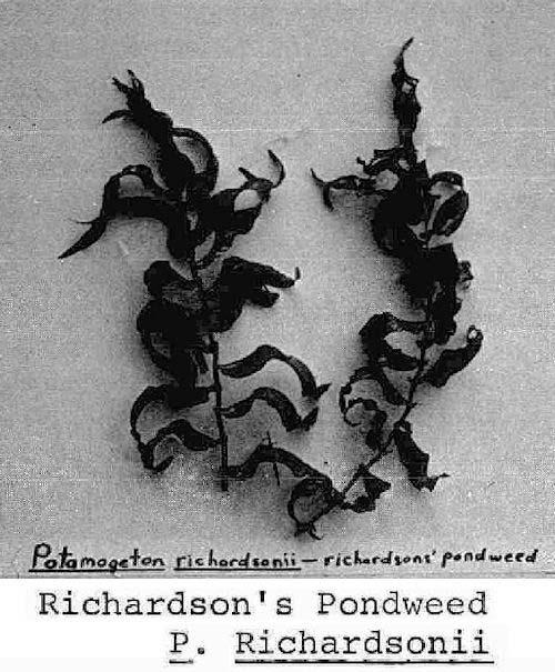
 Milfoil Perennial aquatics, submersed with slender sparingly branched stems, rooting freely at lower nodes.")
28 APPENDIX I: Descriptions and photographs of major plant types. Plant descriptions from Lawrence and Weldon,"Obnoxious Aquatic Plants Affecting Water Resources" A) Milfoil Perennial aquatics, submersed with slender sparingly branched stems, rooting freely at lower nodes. Leaves whorled, variable; pinnately dissected into Filiform segments to those reduced to bracts leaf dissection variable from submersed to immersed form. Flowers very small born either in axils of immersed leaves, or bracts. Well distributed throughout Canada. -23-
.")
29 B) Chara: Plants large, erect, stem like. Whorled branches and forked leaves that are rough to the touch (often lime encrusted). Crushed plants produce a musk-like odour. Almost always in hard water. -24-
30 C) Frogbit Family: Perennial, slender-stemmed, branching submersed aquatic plants, with whorled thin linear leaves and fibrous roots, or submersed plants with clusters of leaves at nodes of rhizomes. Flowers borne on peduncle above surface of water. -25-

31 D) Pondweeds Found in fresh or brackish waters, submersed aquatic plants with creeping rootstocks. Leaves mostly alternate, may be opposite on erect jointed stems. Leaves all alike or may be two kinds; all submersed or some of them floating. Submersed leaves thin and linear or all broad. Immersed leaves broad more or less elliptical and petioled. Seed heads small and crowded into spikes. Spikes raised to surface on long peduncle and/or submersed on short peduncle. Winter buds produced in axils of leaves of some species. Creeping rootstock of other species may terminate in tubers. The largest family of truly aquatic plant, widely distributed throughout Canada. -26-
32 -27-
 which are digested and serve as partial nourishment for the plant.")
33 E) BLADDERWORT FAMILY: Submersed or floating rootless plants with flaccid finely dissected or filiform simple leaves. Many of the leaf segments with small bladders that have little trap doors. These bladders may trap small aquatic animals (amphipods, midges) which are digested and serve as partial nourishment for the plant. Solitary flowers appear above the water on short erect peduncle and are either yellow or purple. -28-
34 APPENDIX II: A Tabulation Of The Variety And Density Of Plants Found At Each Sampling Location. PLANT TYPE SAMPLING LOCATIONS AND DENSITY RATINGS 1 2a 2b 2c a 7b 8 8b a 15b Anacharis canadensis I III III IV III III III Ceratophyllum demersum IV III Chara II II I II III II I II II II II III I Eriocaulon septangulare Heteranthera dubia Myriophyllum II III III II III IV IV IV IV III II III IV IV III III III IV IV Najas flexilis IV IV IV II III III III Potamogeton amplifolius III III IV IV III III III III angustifolius crispus IV III gramineus pectinatus IV III II praelongus pusillus IV II IV richardsonii II IV III III II robinsii III zosteriformis III III III IV III III Ranunculus II III III Utricularia III III III IV IV III III Vallisneria americana IV III II III IV III II III I III I I III -29-
35 APPENDIX II - Cont'd PLANT TYPE SAMPLING LOCATIONS AND DENSITY RATINGS 15c 15d 15e 15f 15g 16a 16b 16c 16d 16e 17a 17b 17c 17d 17e 18a Anacharis canadensis III III IV III Ceratophyllum demersum IV IV Chara II II I II I II III II I I II II Eriocaulon septangulare Heteranthera dubia Myriophyllum IV IV III III III IV IV IV III IV IV Najas flexilis IV III IV II III III III Potamogeton amplifolius III III III III III III angustifolius III crispus III III gramineus pectinatus praelongus pusillus III IV richardsonii III IV III III IV III robinsii zosteriformis III IV III Ranunculus Utricularia III III III IV Vallisneria americana III III III II III II III III III -30-
36 APPENDIX II - Cont'd PLANT TYPE SAMPLING LOCATIONS AND DENSITY RATINGS 18b 18c 18d 19 20a 20b 20c 21a 21b 21c 21d 21e 22a 22b 22c 23a 1 Anacharis canadensis III III Certophyllum demersum IV Chara II II II II II II I III II II I I Eriocaulon septangulare Heteranthera dubia Myriophyllum IV IV IV III IV IV IV IV II IV Najas flexilis IV I III III IV IV II III Potamogeton amplifolius IV III IV IV IV III III III III IV angustifolius III crispus IV III III III III III gramineus III pectinatus II IV praelongus IV III pusillus IV richardsonii III III robinsii zosteriformis IV IV IV III Ranunculus Utricularia IV IV III Vallisneria americana III III IV II III II IV III III III III III IV -31-
37 APPENDIX II - Cont'd PLANT TYPE SAMPLING LOCATIONS AND DENSITY RATINGS 23a 2 23b 23c 24a 24c 25a 25b 25c 26a 26b 26c 27a 27b 27c 28a 28b Anacharis canadensis IV III III IV Ceratophyllum demersum Chara II I II II III II II II II II IV III I Eriocaulon septangulare III Heteranthera dubia IV Myriophyllum II IV IV IV IV IV III III IV IV III III III Najas flexilis III IV III II III III IV II II Potamogeton amplifolius III IV III III III III angustifolius IV crispus III gramineus III II IV III IV III pectinatus IV IV III praelongus pusillus IV richardsonii III III IV III robinsii zosteriformis III IV IV IV Ranunculus Utricularia IV IV Vallisneria americana III IV IV III III III III III -32-
38 APPENDIX II - Cont'd... PLANT TYPE SAMPLING LOCATIONS AND DENSITY RATINGS 28c 29a 29b a 33b 33c d 38b Anacharis canadensis III III III IV Ceratophyllum demersum III Chara II II I II II II III II II II I I I Eriocaulon septangulare Heteranthera dubia Myriophyllum IV III IV III IV III III IV III IV III IV IV IV IV Najas flexilis III II III II I I III II III I III II III III Potamogeton amplifolius III III IV III IV IV angustifolius III crispus gramineus III III III III III III III IV pectinatus II IV III praelongus IV IV III pusillus IV III richardsonii III IV IV IV IV IV III robinsii IV zosteriformis III III III IV Ranunculus IV IV Utricularia IV IV IV IV IV III IV IV IV IV Vallisneria americana III III III III II I I I II III II III II -33-
Aquatic Plant Point-Intercept Survey for Pike Lake, Scott County, Minnesota
 Campers on Pike Lake, Scott County, Minnesota, 2015 Aquatic Plant Point-Intercept Survey for Pike Lake, Scott County, Minnesota [Plant Survey Conducted August 24, 2015] Prepared for: Prior Lake/Spring
Aquatic Plants of the Three Lakes
 Aquatic Plants of the Three Lakes Chris Doyle, CLM Senior Aquatic Biologist/Water Quality Program Supervisor Allied Biological, Inc. 580 Rockport Road Hackettstown, NJ 07840 Phone: 908-850-0303 E-mail:
Aquatic Plant Point-Intercept Survey for Cates Lake, Scott County, Minnesota
 American Lotus in Cates Lake, Scott County, Minnesota, 2016 Aquatic Plant Point-Intercept Survey for Cates Lake, Scott County, Minnesota [Plant Survey Conducted August 29, 2016] Prepared for: Prior Lake-Spring
Chateaugay Lakes Milfoil Control Program
 Chateaugay Lakes Milfoil Control Program Summary of Activities and Findings for June August 29 Prepared By: Daniel L. Kelting Executive Director Adirondack Watershed Institute Paul Smith's College P.O.
BIG MARINE LAKE, WASHINGTON COUNTY: 2017 AQUATIC VEGETATION REPORT
 BIG MARINE LAKE, WASHINGTON COUNTY: 2017 AQUATIC VEGETATION REPORT Report by the Invasive Species Program Division of Ecological and Water Resources Minnesota Department of Natural Resources Lake: Big
Kerr Lake Vegetation Survey. October November Report submitted by NC State University. Background
 Kerr Lake Vegetation Survey October November 2012 Report submitted by NC State University Background Hydrilla (Hydrilla verticillata) is a non-native invasive submersed aquatic plant. This plant was first
PROCEDURE FOR MONITORING AN AQUATIC PLANT PROBLEM 1
 PROCEDURE FOR MONITORING AN AQUATIC PLANT PROBLEM 1 The density, diversity, and growth patterns of aquatic plants are unique to each lake. Therefore, many of the details concerning sample site locations
2015 Starry Stonewort Inspection and Assessment Report: Lake Koronis, Stearns County MNDNR Division of Ecological and Water Resources
 Lake: Koronis (DOW#73020000) County: Stearns Report type: Starry stonewort Inspection and Assessment MNDNR Field Contributors: Christine Jurek (Invasive Species Specialist), Courtney Millaway (Natural
DRAFT AMENDMENT 1. Introduction
 DRAFT AMENDMENT 1 Aquatic Plant Management Plan, Yahara River and Upper Mud Lake, Lower Rock River Basin, Dane County Wisconsin Approved by the Dane County Lakes and Watershed Commission on and by the
GRASS CARP SPAWNING IN LAKE ERIE TRIBUTARIES: WHEN AND WHERE?
 GRASS CARP SPAWNING IN LAKE ERIE TRIBUTARIES: WHEN AND WHERE? Nicole R. King 1, Patrick M. Kocovsky 2, Christine M. Mayer, 1 Song S. Qian 1 1. University of Toledo Dept. Environmental Sciences and Lake
2015 Macrophyte Survey Results
 Invasive Macrophyte Survey Pilot 2015 2015 Macrophyte Survey Results COMPLETED WITH SUPPORT FROM: Acknowledgments The Invasive Plant Monitoring Program was made possible through the support of Alberta
Osoyoos Lake Aquatic Plant Mapping
 Osoyoos Lake Aquatic Plant Mapping AquaTechnex, LLC Presented to Okanogan County NWCB by PO Box 30824 Bellingham WA, 98228 www.aquatechnex.com Introductions Myriophyllum spicatum or Eurasian Milfoil has
AQUATIC PLANT MANAGEMENT PLAN
 AQUATIC PLANT MANAGEMENT PLAN JENNI AND KYLE PRESERVE PONDS TENNEY PARK LAGOON VILAS PARK LAGOON WARNER PARK LAGOON Lower Rock River Basin and VERONA QUARRY Grant-Platte-Sugar-Pecatonica Basin DANE COUNTY,
Mud Bay SLELO-PRISM Water Chestnut & Hydrilla Surveillance 2012
 St. Lawrence Eastern Lake Ontario Partnership for Regional Invasive Species Management Mud Bay Water Chestnut & Hydrilla Surveillance 2012 June 27 th (Water Chestnut) & August 2 (Hydrilla), 2012 Figure
MEMORANDUM Comfort Lake-Forest Lake Watershed District
 MEMORANDUM Comfort Lake-Forest Lake Watershed District To: Board of Managers Date: December 7, 2016 From: Mike Kinney Subject: 2016 Watercraft Inspections and AIS Report Summaries Watercraft Inspection
Table 1. Physical Characteristics of Your Lake.
 The lake assessments are created in partnership with Hillsborough County and the Florida Center for Community Design and Research LAKE ASSESSMENT DOCUMENT White Trout Lake /8/98 Watershed: Sweetwater Creek
Starry Stonewort in Silver Lake Washington County, WI BRAD STECKART AIS COORDINATOR FOR WASHINGTON AND WAUKESHA COUNTIES
 Starry Stonewort in Silver Lake Washington County, WI BRAD STECKART AIS COORDINATOR FOR WASHINGTON AND WAUKESHA COUNTIES Brad Steckart -AIS coordinator for Washington and Waukesha Counties -Graduated from
MaxDepth Aquatics, Inc.
 MaxDepth Aquatics, Inc. Hydroacoustic Survey and Point Sampling of Macrophytes In Diamond Lake 2009 A Report to the Partners for Umpqua Rivers Roseburg, OR And the Umpqua National Forest Roseburg, OR By
2014 Island Lake Survey June 13 th, 2014 Andrew Plauck District Fisheries Biologist Report Prepared 4 March 2015
 2014 Island Lake Survey June 13 th, 2014 Andrew Plauck District Fisheries Biologist Report Prepared 4 March 2015 BACKGROUND - A fish survey was requested due to a moderately severe winterkill in Island
Aquatic Plant Surveys in Donner Lake State Park, California: Report to California State Parks. Final Draft
 Aquatic Plant Surveys in Donner Lake State Park, California: 2017 Report to California State Parks Final Draft Brant Allen, Katie Senft, and Brandon Berry UC Davis Tahoe Environmental Research Center February
Eurasian Water-milfoil Bed Mapping Survey Red Lake (WBIC: ) Douglas County, Wisconsin
 Douglas County, Wisconsin") Eurasian Water-milfoil Bed Mapping Survey Red Lake (WBIC: 2492100) Douglas County, Wisconsin Red Lake Eurasian water-milfoil with >12 leaflet pairs/limp whorls out of water EWM Beds on Red Lake 10/2/16
Eurasian Water-milfoil Bed Mapping Survey Red Lake (WBIC: 2492100) Douglas County, Wisconsin Red Lake Eurasian water-milfoil with >12 leaflet pairs/limp whorls out of water EWM Beds on Red Lake 10/2/16
Aquatic Vegetation of Bass Lake
 Aquatic Vegetation of Bass Lake July, August and September, 2012 Bulrush, wild rice and waterlilies in channel between the North and South basins of Bass Lake, 2012. Bass Lake, ID# 31-0576-00 Itasca County,
Aquatic Plant Management and Importance to Sport Fisheries
 Aquatic Plant Management and Importance to Sport Fisheries Presentation to Michigan Inland Lakes Convention May 2014 Mike Maceina Professor Emeritus School of Fisheries, Aquaculture, and Aquatic Sciences
Big Fish Lake Association Marcellus, MI 49067
 Marcellus Lakes 2013 Annual Progress Report An Annual Assessment of Aquatic Vegetation & Water Quality in Big Fish, Saddlebag, and Finch Lakes Cass County, Michigan Prepared for: Prepared by: Chris Brooks
Fish Community. Fish Habitat, Streams and Rivers
 Clear, Ston(e)y and White Lake Plan Fish Community The lakes support a cool/warm water fishery including muskellunge, walleye, largemouth and smallmouth bass, yellow perch, pumpkinseed, rockbass, blue
2014 Threatened and Endangered Fish Survey of. East Loon Lake and West Loon Lake. Lake County, Illinois
 2014 Threatened and Endangered Fish Survey of East Loon Lake and West Loon Lake Lake County, Illinois Prepared by Integrated Lakes Management 120 LeBaron St. Waukegan, IL 60085. Chris Ryan Chris Rysso
Flowering Rush An Invasive Aquatic Macrophyte Infesting the Columbia River Basin
 Flowering Rush An Invasive Aquatic Macrophyte Infesting the Columbia River Basin Virgil Dupuis Salish Kootenai College Peter Rice University of Montana Pacific Northwest Distribution Montana Distribution
Dexter Marsh Wildlife Management Area and Muskellunge Creek: Water Hyacinth (Eichhornia crassipes) Assessment
 Assessment") St. Lawrence Eastern Lake Ontario Partnership for Regional Invasive Species Management Special Note The partners of the SLELO PRISM have identified 2 Priority Conservation Areas on which we conduct early
St. Lawrence Eastern Lake Ontario Partnership for Regional Invasive Species Management Special Note The partners of the SLELO PRISM have identified 2 Priority Conservation Areas on which we conduct early
MIDDLE FORK RESERVOIR Wayne County 2004 Fish Management Report. Christopher C. Long Assistant Fisheries Biologist
 MIDDLE FORK RESERVOIR Wayne County 2004 Fish Management Report Christopher C. Long Assistant Fisheries Biologist FISHERIES SECTION INDIANA DEPARTMENT OF NATURAL RESOURCES DIVISION OF FISH AND WILDLIFE
AN ANALYSIS OF FISHING EFFORT AT INDIAN LAKE
 AN ANALYSIS OF FISHING EFFORT AT INDIAN LAKE LOWELL E. BINKLEY.i Section of Fish Management and Propagation, Ohio Division of Conservation and Natural Resources, Columbus, Ohio Although the study of natural
REQUEST FOR BID FOR DIVER ASSISTED SUCTION HARVESTING
 REQUEST FOR BID FOR DIVER ASSISTED SUCTION HARVESTING Located on Black Otter Lake, Village of Hortonville, Outagamie County Issued on: January 18, 2018 Due Date: March 16, 2018, 12:00PM Administered by:
LAKE PLEASANT Steuben County 2006 Fish Management Report. Larry A. Koza Assistant Fisheries Biologist
 LAKE PLEASANT Steuben County 2006 Fish Management Report Larry A. Koza Assistant Fisheries Biologist Fisheries Section Indiana Department of Natural Resources Division of Fish and Wildlife I.G.C.-South,
Fighting Milfoil at Lake Louise
 Fighting Milfoil at Lake Louise Presentation by Cottagers Council, Lake Louise Christian Community Charlevoix County Parks and Recreation Committee April 20, 2015 Lake Louise Christian Community (LLCC)
Crooked Lake Oakland County (T4N, R9E, Sections 3, 4, 9) Surveyed May James T. Francis
 Surveyed May James T. Francis") Michigan Department of Natural Resources Status of the Fishery Resource Report No. 2004-1, 2004 Crooked Lake Oakland County (T4N, R9E, Sections 3, 4, 9) Surveyed May 2002 James T. Francis Environment Crooked
Michigan Department of Natural Resources Status of the Fishery Resource Report No. 2004-1, 2004 Crooked Lake Oakland County (T4N, R9E, Sections 3, 4, 9) Surveyed May 2002 James T. Francis Environment Crooked
Adapting to Climate Change In Coastal Environments
 Adapting to Climate Change In Coastal Environments Peter Nimmrichter, P.Eng. AMEC Earth and Environmental, Mississauga, Ontario 19/11/2007 1 The Great Lakes Watershed The Great Lakes cover an area of 244,160
Warm-up # 7 A day 5/17 - B day 5/18 UPDATE YOUR TABLE OF CONTENTS
 Warm-up # 7 A day 5/17 - B day 5/18 UPDATE YOUR TABLE OF CONTENTS Question: List all examples of surface water on Earth. Answer: Rivers and streams, lakes and reservoirs, (ponds) wetlands, estuaries and
Summary of Diver Assisted Suction Harvesting Efforts. Lake Ellwood Florence County, WI
 2527 Lake Ottawa Road Iron River, MI 49935 906.284.2198 Summary of Diver Assisted Suction Harvesting Efforts Lake Ellwood Florence County, WI 2015 WDNR Mechanical Harvesting Permit Annual Report Permit
Habitat Fact Sheets. Rocky habitats are dominated by seaweeds and often mussels, which rely on the rocks for attachment.
 Habitat Fact Sheets Habitats in the Gulf of Maine serve many important roles for the environment and for humans as well. These include: cycling nutrients, filtering pollution, trapping sediments, storing
Management of Hybrid Watermilfoil (Myriophyllum sibericum x spicatum) using Diver Assisted Suction Harvesting
 using Diver Assisted Suction Harvesting") 2527 Lake Ottawa Road Iron River, MI 49935 906.284.2198 Management of Hybrid Watermilfoil (Myriophyllum sibericum x spicatum) using Diver Assisted Suction Harvesting Lake Ellwood, Florence, WI - 2014 Final
2527 Lake Ottawa Road Iron River, MI 49935 906.284.2198 Management of Hybrid Watermilfoil (Myriophyllum sibericum x spicatum) using Diver Assisted Suction Harvesting Lake Ellwood, Florence, WI - 2014 Final
Marine Ecosystems. Aquatic Ecosystems Section 2
 Marine Ecosystems Marine ecosystems are located mainly in coastal areas and in the open ocean. Organisms that live in coastal areas adapt to changes in water level and salinity. Organisms that live in
Glen Echo Lake Weed Biomass Study
 Weed Biomass Study Charlton, Massachusetts PREPARED FOR: Glen Echo Improvement Association PO Box 578 01508 PREPARED BY: ESS Group, Inc. 100 Fifth Avenue, 5th Floor Waltham, Massachusetts 02451 ESS Project
MARTINDALE POND Wayne County 2004 Fish Management Report. Christopher C. Long Assistant Fisheries Biologist
 MARTINDALE POND Wayne County 2004 Fish Management Report Christopher C. Long Assistant Fisheries Biologist Fisheries Section Indiana Department of Natural Resources Division of Fish and Wildlife I.G.C.
SOONER LAKE MANAGEMENT PLAN
 SOONER LAKE MANAGEMENT PLAN Background Lake Sooner impounds Greasy Creek, 15 miles south of Ponca City in Noble and Pawnee Counties, Oklahoma (Figure 1). The Grease Creek basin that Sooner Lake impounds
Current Status and Management Recommendations for the Fishery in the Cloverleaf Chain of Lakes
 Current Status and Management Recommendations for the Fishery in the Cloverleaf Chain of Lakes Jason Breeggemann Senior Fisheries Biologist Wisconsin Department of Natural Resources Outline DNR fisheries
Environmental. Effects of Dredging
 Envi~onmental Effects of Dredging Technical Notes THE VALUE OF GRAVEL DISPOSAL MOUNDS IN RIVER SIDE CHANNELS FOR FRESHWATER MUSSELS PURPOSE: This note provides information on the value of gravel disposal
BEAUTIFUL... OR BLIGHTED? AN APPREHENSIVE LOOK AT OUR LAKESHORES
 BEAUTIFUL... OR BLIGHTED? AN APPREHENSIVE LOOK AT OUR LAKESHORES JACK SKRYP'EK * Trends indicate that all North Central Minnesota lakeshore will be fully developed by the mid-1970's. * Is indiscriminate
Nothing So Constant as Change
 Nothing So Constant as Change By Ron Schaper Dynamic Environments 1) Lake Levels 2) Beach Size 3) Cliff Erosion 4) Beach and Cliff Plant Communities 1) Lake Levels (Michigan/Huron) More than 20,000 years
EcoLogic Memorandum. TO: Ben Brezell; EDR FROM: Mark Arrigo RE: Possible Impacts of Dredging Snooks Pond DATE: 6/4/07
 EcoLogic Memorandum TO: Ben Brezell; EDR FROM: Mark Arrigo RE: Possible Impacts of Dredging Snooks Pond DATE: 6/4/07 Background EDR P.C. (EDR) has been contracted by a landowner to assess the feasibility
Pond Management. Dan Lekie Agriculture & Natural Resource Agent K-State Research & Extension Johnson County
 Pond Management Dan Lekie Agriculture & Natural Resource Agent K-State Research & Extension Johnson County Pond Management Basics Plant ID and Control Fish Management Wildlife Concerns Management Options
BASELINE SURVEY OF AQUATIC PLANTS LAKE MURRAY, SC 2007
 BASELINE SURVEY OF AQUATIC PLANTS LAKE MURRAY, SC 2007 Prepared for: South Carolina Electric & Gas Company prepared by: Cynthia A. Aulbach Botanical Services of South Carolina Lexington, SC 29072 December
BIG TWIN LAKE Kalkaska County (T28N, R05W, Section 18, and T28N, R06W, Section 13) Surveyed May 1999
 Surveyed May 1999") Michigan Department of Natural Resources Status of the Fishery Resource Report No. 2001-1, Year 2001 BIG TWIN LAKE Kalkaska County (T28N, R05W, Section 18, and T28N, R06W, Section 13) Surveyed May 1999
Michigan Department of Natural Resources Status of the Fishery Resource Report No. 2001-1, Year 2001 BIG TWIN LAKE Kalkaska County (T28N, R05W, Section 18, and T28N, R06W, Section 13) Surveyed May 1999
Cedar Lake Comprehensive Survey Report Steve Hogler and Steve Surendonk WDNR-Mishicot
 Cedar Lake- 2006 Comprehensive Survey Report Steve Hogler and Steve Surendonk WDNR-Mishicot ABSTRACT Cedar Lake is a 142 acre lake located in the southwest corner of Manitowoc County. It is a seepage lake
Starry Stonewort. A new aquatic invader in Wisconsin. Michelle Nault Wisconsin Department of Natural Resources
 Starry Stonewort A new aquatic invader in Wisconsin Michelle Nault Wisconsin Department of Natural Resources Michelle.Nault@Wisconsin.gov Photo: Paul Skawinski What is starry stonewort? Starry stonewort
LaSalle Park Marina Wave Break
 LaSalle Park Marina Wave Break Federal and Municipal Environmental Assessment Background History of the Marina and LaSalle Park The LaSalle Park Marina is located in LaSalle Park at the foot of LaSalle
FACT SHEET MCGREGOR LAKE RESTORATION HABITAT PROJECT POOL 10, UPPER MISSISSIPPI RIVER, WISCONSIN ENVIRONMENTAL MANAGEMENT PROGRAM
 FACT SHEET MCGREGOR LAKE RESTORATION HABITAT PROJECT POOL 10, UPPER MISSISSIPPI RIVER, WISCONSIN ENVIRONMENTAL MANAGEMENT PROGRAM LOCATION McGregor Lake is located within a mid-river island in Pool 10
Overview. What are Corals?
 Overview Coral Reefs extend back over 500 m.y. Grow in tropical seas with normal salinity Support a great variety of plant and animal life Cover less than 0.2% of sea floor Contain about 25% of marine
Nearshore Habitat Mapping in Puget Sound Using Side Scan Sonar and Underwater Video
 Nearshore Habitat Mapping in Puget Sound Using Side Scan Sonar and Underwater Video Dana Woodruff, Paul Farley, Amy Borde, John Southard, Ron Thom Battelle Marine Sciences Laboratory Jim Norris Marine
KICKAPOO LAKE Shakamak State Park Sullivan, Greene, and Clay Counties 2009 Fish Management Report. David S. Kittaka Fisheries Biologist
 KICKAPOO LAKE Shakamak State Park Sullivan, Greene, and Clay Counties 2009 Fish Management Report David S. Kittaka Fisheries Biologist Fisheries Section Indiana Department of Natural Resources Division
HARBOUR SEDIMENTATION - COMPARISON WITH MODEL
 HARBOUR SEDIMENTATION - COMPARISON WITH MODEL ABSTRACT A mobile-bed model study of Pointe Sapin Harbour, in the Gulf of St. Lawrence, resulted in construction of a detached breakwater and sand trap to
CARL BLACKWELL LAKE MANAGEMENT PLAN
 CARL BLACKWELL LAKE MANAGEMENT PLAN Background Lake Carl Blackwell impounds Stillwater Creek, 10 miles west of Stillwater in Payne County, Oklahoma (Figure 1). The lake covers 3,370 surface acres and was
Seagrasses: Vital Habitat in Texas Estuaries
 Seagrasses: Vital Habitat in Texas Estuaries Cindy Hobson Water Resources Branch Coastal Fisheries Division Texas Parks and Wildlife Department February 17, 2015 Why Care About Seagrass? Sustain coastal
located Let s go fishing Hydrilla
 Our Lake of the Month for November is Lake August (set your GPS to 27.2750-81.4136). The elevation of Lake August is 102.5. Lake August is a 52 acre dredge hole lake (man-made from a former wetland; see
Eurasian water-milfoil (Myriophyllum spicatum) SCUBA Dive Monitoring Survey Sand Bar Lake WBIC: Bayfield County, Wisconsin
 SCUBA Dive Monitoring Survey Sand Bar Lake WBIC: Bayfield County, Wisconsin") Eurasian water-milfoil (Myriophyllum spicatum) SCUBA Dive Monitoring Survey Sand Bar Lake WBIC: 2494900 Bayfield County, Wisconsin 6ft EWM Towers with Rooted Branch Preparing to Fall Off (Berg 2016) EWM
Eurasian water-milfoil (Myriophyllum spicatum) SCUBA Dive Monitoring Survey Sand Bar Lake WBIC: 2494900 Bayfield County, Wisconsin 6ft EWM Towers with Rooted Branch Preparing to Fall Off (Berg 2016) EWM
JadEco, LLC PO BOX 445 Shannon, IL 61078
 Introduction: With the assistance of Lake Holiday staff and volunteers, we were able to conduct an AC electrofishing survey on May 8, 27. Water temperatures were 2.3 C (8.5 F) and water clarity was decent
Assessing the Risk of AIS in Waters with no Public Boat Access Hennepin County 2018
 Assessing the Risk of AIS in Waters with no Public Boat Access Hennepin County 2018 Fortin Consulting, Inc. January 2019 Contents Assessing the Risk of AIS in Waters with no Public Boat Access... 2 Executive
Flowering Rush An Invasive Aquatic Macrophyte Infesting the Columbia River Basin
 Flowering Rush An Invasive Aquatic Macrophyte Infesting the Columbia River Basin Peter Rice, University of Montana, Virgil Dupuis, Salish Kootenai i College Flowering Rush (Butomus umbellatus) umbel shaped
LITTLE WHITE OAK Knox County 2006 Fish Management Report. Debbie King Assistant Fisheries Biologist
 LITTLE WHITE OAK Knox County 2006 Fish Management Report Debbie King Assistant Fisheries Biologist Fisheries Section Indiana Department of Natural Resources Division of Fish and Wildlife I.G.C.-South,
Warmwater Fisheries Assessments 2014
 NJDEP Division of Fish and Wildlife Bureau of Freshwater Fisheries Warmwater Fisheries Assessments 2014 New Jersey has over 400 impoundments open to the general public for fishing and thousands more in
RECREATIONAL PONDS AND LAKES
 RECREATIONAL PONDS AND LAKES POND ECOLOGY AQUATIC PLANTS & FISH F.S. Conte Department of Animal Science University of California Davis Photos By Flickr AQUATIC PLANTS POND HEALTH Chemical Recycling Oxygen
Water Habitat Model. Outcome: Materials: Teacher Instructions: : Identify the components of an animal habitat..
 Water Habitat Model Outcome: 4-1-03: Identify the components of an animal habitat.. Materials: Shoe boxes (1 per student) Art supplies: Glue and/or tape Paint and brushes for the background Plasticine/clay
The Loon Pond Experience
 Bridgewater State University Virtual Commons - Bridgewater State University Watershed Access Lab Projects Watershed Access Lab 2005 The Loon Pond Experience Recommended Citation Apponequet Regional High
Michigan Dept. of Natural Resources Status of the Fishery Resource Report Page 1. Weber Lake Cheboygan County, T34N, R3W, Sec.
 Michigan Dept. of Natural Resources 2012-143 Status of the Fishery Resource Report Page 1 Weber Lake Cheboygan County, T34N, R3W, Sec. 31 Neal Godby, Fisheries Biologist Environment Weber Lake is a 28.5-acre
MISSISSIPPI MAKEOVER A Plan for Restoration, Just Around the Bend
 MISSISSIPPI MAKEOVER A Plan for Restoration, Just Around the Bend Interim Report Card 2013 Project coordinated by the Dakota County Soil and Water Conservation District and sponsored by the Minnesota Pollution
UNIVERSITY OF. ILL»hOlS LIBRARY AT URBANA-CHAMPAIGN NATURAL HIST. SURVEY
 UNIVERSITY OF ILL»hOlS LIBRARY AT URBANA-CHAMPAIGN NATURAL HIST. SURVEY Digitized by the Internet Archive in 2010 with funding from University of Illinois Urbana-Champaign http://www.archive.org/details/controllingaquat57wile
Fish population survey report
 Fish population survey report Upper River Avon Catchment This report provides a summary of results from recent fish population surveys on the Tetbury Avon, Sherston Avon and River Marden The surveys were
Management of Small Impoundments
 Management of Small Impoundments Chapter 12 (Lake food webs) Chapter 15 (Natural Lakes) Chapter 16 (Farm Ponds & Small Impoundments) Quote for today: "The gods do not deduct from man's allotted span the
Water-level change effects on northern pike spawning and nursery habitat and reproductive success in Rainy Lake and Namakan Reservoir, Minnesota
 Water-level change effects on northern pike spawning and nursery habitat and reproductive success in Rainy Lake and Namakan Reservoir, Minnesota Principal Investigator: Principal CO-Investigator: Anne
LAKE MANAGEMENT PLAN
 LAKE MANAGEMENT PLAN Region Area DOW Number County DOW Lake Name Acreage 2 Duluth F213 69-0041 St. Louis Bassett DOW: 436 Plan: 442 Long Range Goal: Manage for walleye with a gillnet catch rate greater
Background Report #3. Our Water Fishability
 Background Report #3 Our Water Fishability July 2004 OUR WATER- FISHABILITY Indicator Are We Happy? Are Things Improving No restrictions on eating local fish. Healthy fish populations.? Why are we concerned
Three Rivers Cockle Abundance Survey Report April 2016
 Three Rivers Cockle Abundance Survey Report April 16 May 16 Crown Copyright WG 2884 ISBN digital 978-1-4734-669-6 1. Introduction The annual Three Rivers Estuaries cockle abundance survey was conducted
Fish Assessment for Sanctuary Pond October 10, 2005
 83 Ambrogio Dr, Suite K Gurnee, IL 60030 8847-244-6662 847-244-0261 fax www.lakesmanagement.com Fish Assessment for Sanctuary Pond October 10, 2005 Prepared For: Dr. Mike Sands Executive Director Liberty
Eelgrass Survey PARADISE CAY BELVEDERE, MARIN COUNTY CALIFORNIA. Prepared For:
 Eelgrass Survey PARADISE CAY BELVEDERE, MARIN COUNTY CALIFORNIA Prepared For: Radford (Skid) Hall, Ph.D. Land Planning and Permitting Consultant 500 Airport Blvd., Suite 350 Burlingame, CA 94010 (650)
We would also like to thank Dr. Martin O Grady (CFB) and No. 3 Operational Wing, Irish Air Corps (Aer Chór na héireann) for the aerial photographs.
 and No. 3 Operational Wing, Irish Air Corps (Aer Chór na héireann) for the aerial photographs.") ACKNOWLEDGEMENTS The authors wish to gratefully acknowledge the help and co-operation of the CEO Mr. Vincent Roche, the assistant CEO Dr. John Conneely and the staff of the North Western Regional Fisheries
ACKNOWLEDGEMENTS The authors wish to gratefully acknowledge the help and co-operation of the CEO Mr. Vincent Roche, the assistant CEO Dr. John Conneely and the staff of the North Western Regional Fisheries
2016 Field Survey Oneida Lake / Three Mile Bay WMA SLELO-PRISM Early Detection Surveillance
 St. Lawrence Eastern Lake Ontario Partnership for Regional Invasive Species Management 2016 Field Survey Oneida Lake / Three Mile Bay WMA Early Detection Surveillance August 3 rd, 4 th, 5 th, and 8 th,
Florida Seagrass Integrated Mapping and Monitoring Program
 Florida Seagrass Integrated Mapping and Monitoring Program - 2004 The following document is composed of excerpts taken from the 2011 publication, Seagrass Integrated Mapping and Monitoring for the State
Overview of Recreational Pond Management
 Overview of Recreational Pond Management extension November 13 th 2013 Forrest Wynne State Extension Specialist for Aquaculture Kentucky State University Ponds are built for some of the following purposes:
Waubee Lake Kosciusko County Fish Management Report 2006
 Waubee Lake Kosciusko County Fish Management Report 2006 Jed Pearson, fisheries biologist Fisheries Section Indiana Department of Natural Resources Division of Fish and Wildlife I.G.C.-South, Room W273
SAV. Watchers. Pocket Field Guide
 Chesapeake Bay SAV Watchers Pocket Field Guide Field packing list Tier 1 On-site reporting Smartphone equipped with the Water Reporter app SAV species guide Off-site reporting Paper Pencil Watch or Clock
Why do different beaches have different types of vegetation?
 Why do different beaches have different types of vegetation? Allan Crowe Environment Canada National Water Research Institute Burlington, Ontario Environment Canada Environnement Canada NATIONAL WATER
Waupaca Chain O' Lakes Anonymous Stakeholder Survey Surveys Distributed: 804 Surveys Returned: 432 Response Rate: 54% Chain Property
 Waupaca Chain O' Lakes Anonymous Stakeholder Survey Surveys Distributed: 84 Surveys Returned: 432 Rate: 54% Chain Property 1. On which lake of the Chain do you reside or own property? Percent Columbia
INLAND LAKE MANAGEMENT REPORT FY Spring 2008
 INLAND LAKE MANAGEMENT REPORT FY 2008 Spring 2008 Prepared by Robert O. Andress District Fisheries Biologist E. Daniel Catchings District Fisheries Supervisor Kevin W. Baswell District Biologist Aide Department
Northwest Montana Lakes Volunteer Monitoring Network 2015 Program Summary 5.7 SMALL LAKES. (Surface Area <100 Acres)
") 5.7 SMALL LAKES (Surface Area
5.7 SMALL LAKES (Surface Area
SKIATOOK LAKE MANAGEMENT PLAN
 SKIATOOK LAKE MANAGEMENT PLAN Background Skiatook Lake impounds Hominy Creek, 5 miles west of Skiatook in Osage County, Oklahoma (Figure 1). Skiatook Lake covers 10,540 surface acres and was constructed
Wampum Lake Population Survey
 Wampum Lake Survey Located in Thornton on Thornton-Lansing Rd. 1½ mile west of Torrence Ave. Wampum Lake is 35 acres is size and has a maximum depth of 14.1 feet. Northern pike, largemouth bass, bluegill,
Two types of physical and biological standards are used to judge the performance of the Wheeler North Reef 1) Absolute standards are measured against
 Absolute standards are measured against") 1 Two types of physical and biological standards are used to judge the performance of the Wheeler North Reef 1) Absolute standards are measured against fixed value at Wheeler North Reef only 2) Relative
1 Two types of physical and biological standards are used to judge the performance of the Wheeler North Reef 1) Absolute standards are measured against fixed value at Wheeler North Reef only 2) Relative
Research Grant Application Barnstead Milfoil Committee Suncook River Milfoil Removal Study
 07-08 Suncook River Milfoil Removal Study A. Brief Description: The, Center Barnstead, NH is submitting a proposal to the NH Department of Environmental Services to develop a procedure and study the results
MINNESOTA DEPARTMENT OF NATURAL RESOURCES DIVISION OF FISHERIES AND WILDLIFE. Gamefish Assessment Report
 Minnesota DNR F-29-R(P) Area F312 February 1, 2013 MINNESOTA DEPARTMENT OF NATURAL RESOURCES DIVISION OF FISHERIES AND WILDLIFE Gamefish Assessment Report Spring Gamefish Assessment on the Mississippi
Current projects for Fisheries Research Unit of Minnesota Department of Natural Resources
 Current projects for Fisheries Research Unit of Minnesota Department of Natural Resources MAJOR RESOURCE ISSUES IN THE DIVISION OF FISHERIES Status of Fish Populations To effectively manage fish populations,
STUDY PERFORMANCE REPORT
 STUDY PERFORMANCE REPORT State: Michigan Project No.: F-80-R-4 Study No.: 702 Title: Effects of sediment traps on Michigan river channels Period Covered: October 1, 2002 to September 30, 2003 Study Objectives:
feeding - clear moderate-sized shallow streams with moderate vegetation spawning - nests in gravel, sand, or hard rock substrate
 orthern longear sunfish (Lepomis peltastes) feeding - clear moderate-sized shallow streams with moderate vegetation - rocky substrates - little to no current spawning - nests in gravel, sand, or hard rock