FINAL HARRIS CHAIN OF LAKES RESTORATION COUNCIL SITE VISIT SUMMARY. of the. Projects Tour March 3, 2006
|
|
|
- MargaretMargaret Webb
- 5 years ago
- Views:
Transcription
1 FINAL HARRIS CHAIN OF LAKES RESTORATION COUNCIL SITE VISIT SUMMARY of the Projects Tour March 3, 2006 The regular meeting of the Harris Chain of Lakes Restoration Council (Council) was cancelled to facilitate site visits to the Burrell Lock and Dam, Lowrie Brown Restoration Site and Lake Griffin Canal Dredging Project. Council members met at the Burrell Lock and Dam for the site visits at 8:45 AM on March 3, Members Present Skip Goerner, Chairman Hugh (Dave) Davis II, Vice Chairman Rick Powers, P.G., Secretary Keith Farner Robert Kaiser, P.E. Don Nicholson Richard Royal Member Not Present Edward M. Schlein, M.D. Ted Woodrell The Council met at the Burrell Lock and Dam to conduct site visits to the property north of the Burrell Lock and Dam, the Lowrie Brown Restoration Site and the Lake Griffin Canal Dredging Project. Below is a summary of observations made and information gained from visiting these locations. The tour consisted of boats to ferry the Council and other visitors to the various locations and airboats to provide a tour of the Lowrie Brown Restoration Area. Several members of the Technical Advisory Group (TAG) to the Council also attended the site visits including Barbara Bess of the Florida Department of Environmental Protection (FDEP), Bill Johnson of the Florida Fish and Wildlife Conservation Commission (FWCC), and Mike Perry of the Lake County Water Authority (LCWA). The Agenda for the site visits is provided as Attachment 1. Burrell Lock and Dam This structure was visited to observe conditions relating to alleged erosion issues of a seawall located immediately north of the spillway leading from the structure. The Burrell Lock and Dam are located on Haines Creek which runs northwest from Lake Eustis to Lake Griffin, in the Harris Chain of Lakes. The allegations were brought forth by Richard Howley who is the owner of the Spillway Park located adjacent to the north side of the spillway. Mr. Howley alleges that the water discharged during peak flows from the Burrell
2 Site Visit Summary March 3, 2006 Page 2 of 7 structure have caused erosion at the base of the seawall along his property. John Richmond of the St. Johns River Water Management District (SJRWMD) had conducted a study of the sediments at the base of the seawall and concluded that hardpan material extends out approximately 4 feet from the base of the wall. Other mitigating factors include the age of the seawall, which is believed to be approximately 22 years and the design / construction of the seawall. It is Mr. Richmond s opinion that only normal erosion has occurred at the base of the seawall. Furthermore, he believes that if the seawall were properly built with horizontal supports leading inland from the wall, then perhaps the leaning and cracking noted along the wall and walkway may not have occurred at this time. While at the site a couple of the Council members used a long, aluminum pole to probe the creek bottom along the seawall. At the locations where they probed the Council members described a hard area leading out from the base of the seawall. Additionally, Councilman Bob Kaiser placed a tennis ball in the water near the western portion of Mr. Howley s property. A gentle current carried the ball back to the east in a small embayment, just north of the Burrell spillway. Mr. Richmond explained that approximately 95% of the year the spillway is operated at the flow rate observed on the day of the site visit and during the other periods of time it is operated at flows which are three to four times greater. The increased flow is necessary to lower the water levels in Lake Eustis and upstream lakes after heavy rainfall events. Councilman Kaiser suggested that extending the jetty leading downstream from the Burrell structure along the northern side may help to alleviate any additional erosion at Mr. Howley s property, which may be affected by the flowing water. Chairman Skip Goerner suggested that perhaps any erosion which has occurred along Mr. Howley s property may only have been exacerbated by water flowing through the Burrell structure and that erosion is a natural process. He suggested that the Council discuss the matter between themselves to make a decision of potential liability and arrive at a satisfactory conclusion. The Council was directed by Florida State Senator Carey Baker to review the matter negotiate an equitable arrangement with Mr. Howley as necessary. Lowrie Brown Restoration Site After boating along Haines Creek from the Burrell Lock and Dam to Lake Griffin, the Council members and other visitors arrived at the location of a pump station from the Lowrie Brown Restoration site to Lake Griffin. Access was made by transversing the levee at that location and boarding airboats. Jay Potinkas, a Project Manager with the SJRWMD provided an overview of the Lowrie Brown Restoration project. He explained that the hurricanes and storms over the previous two years have caused breaches and erosion to the levees that separate Lowrie Brown from both Lake Griffin and Haines Creek, adding that with the breaches the water levels are now about the same. He said that originally the SJRWMD had planned to conduct plantings of wetland vegetation to enhance the functioning of this marsh as a method to improve the quality of water being discharged into
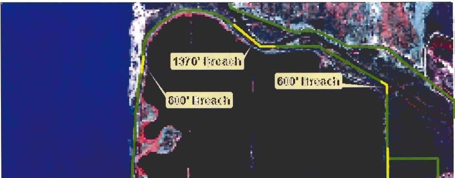
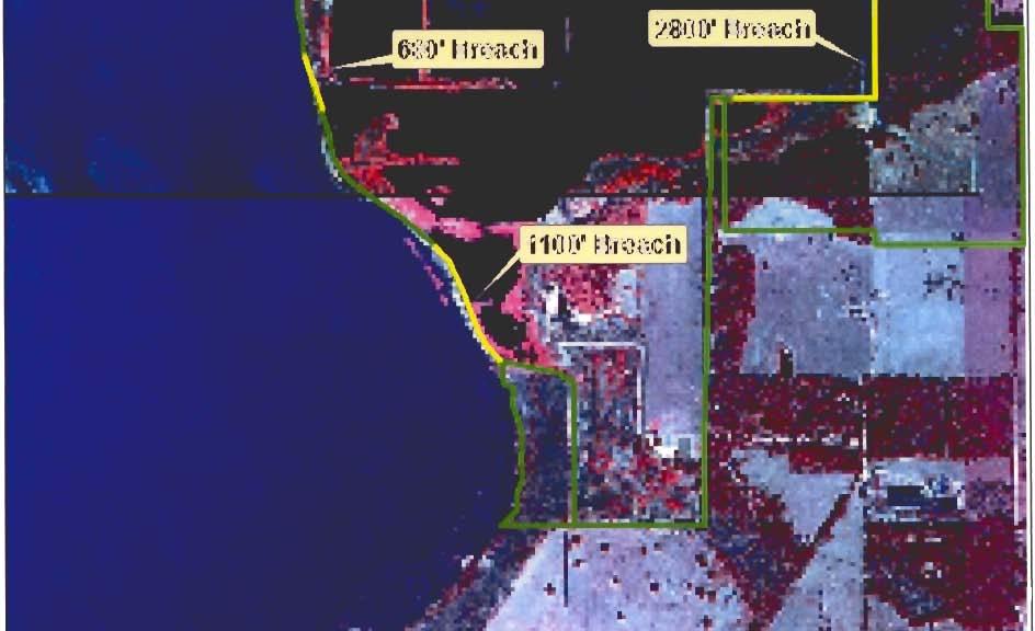
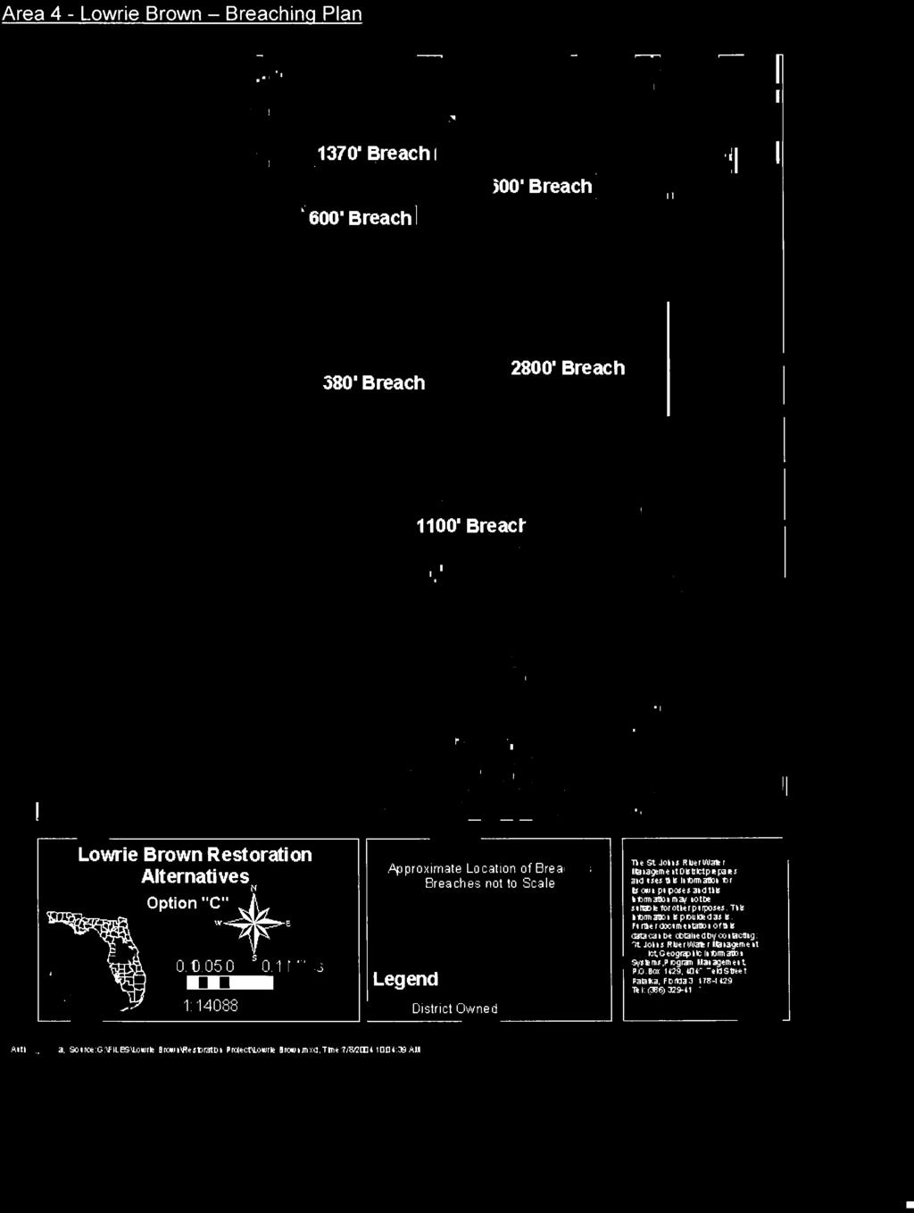
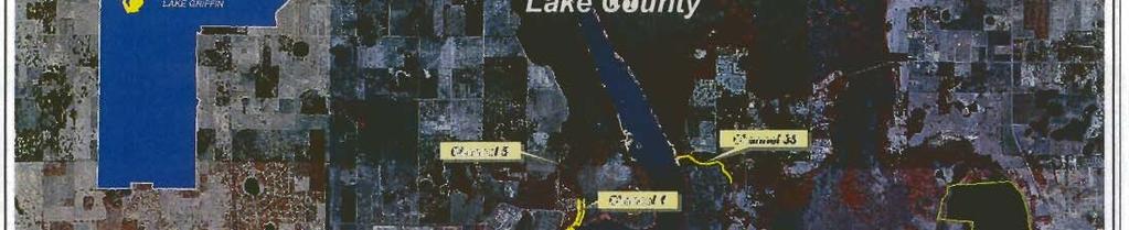
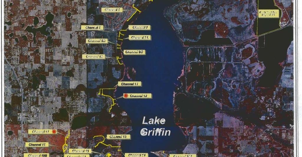
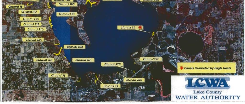
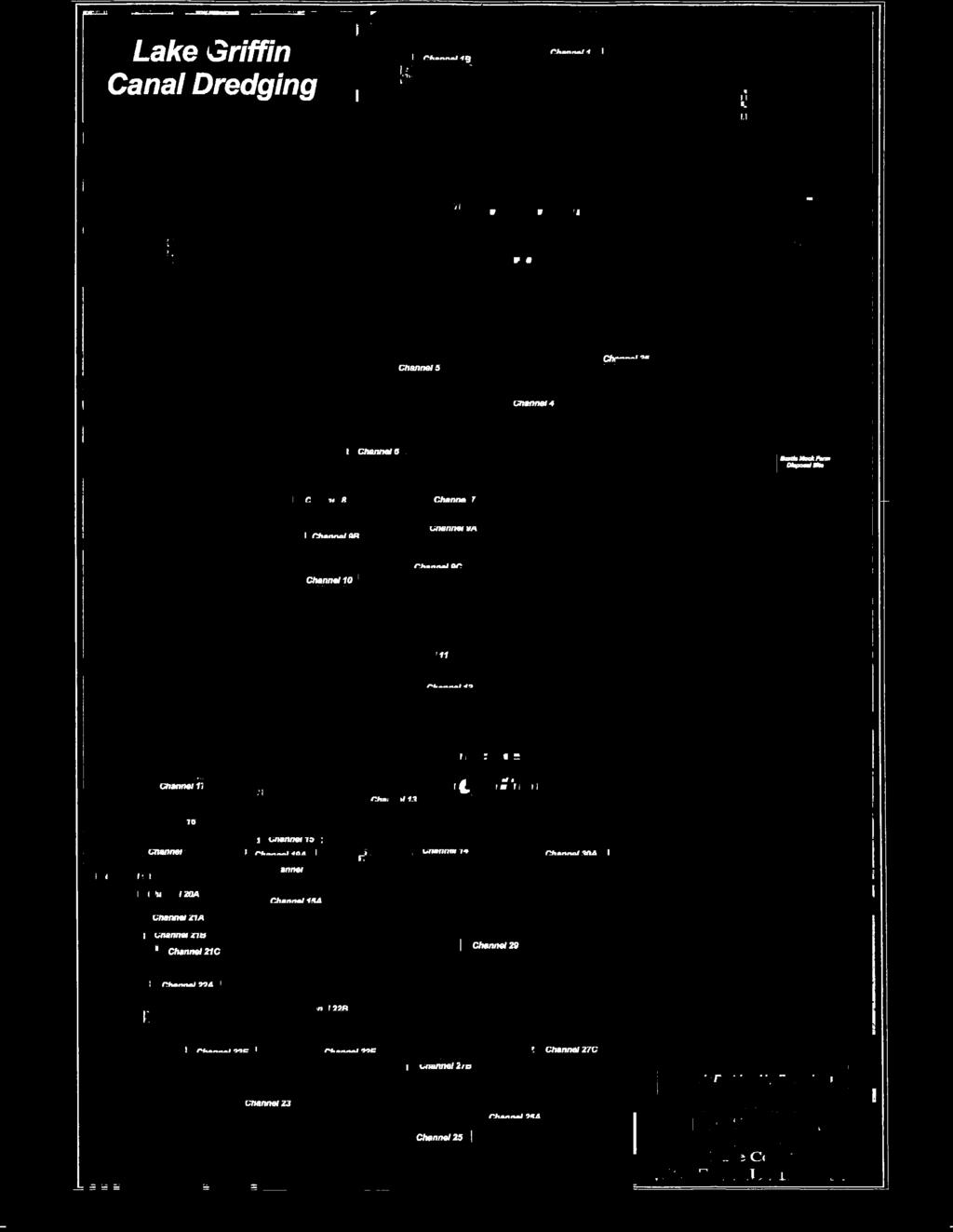
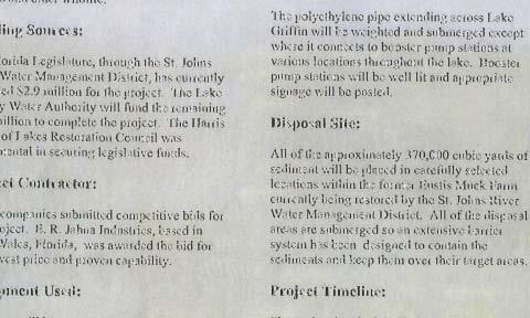
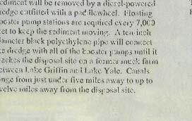
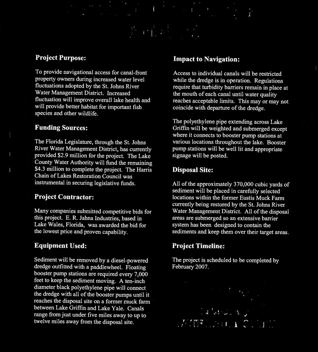
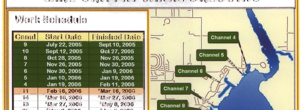
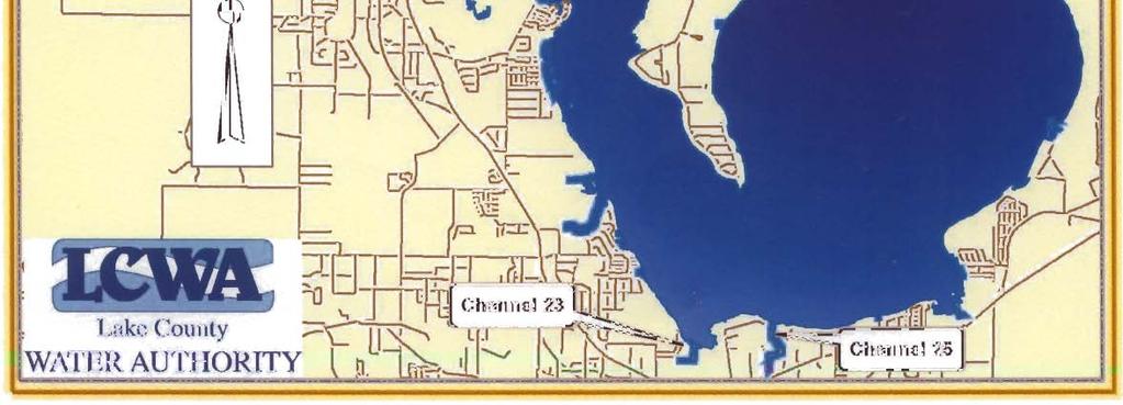
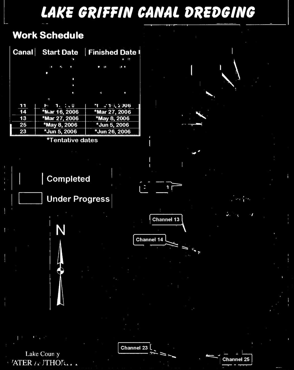
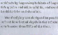
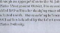
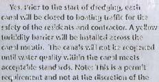
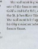
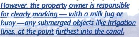
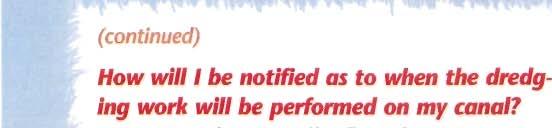
3 Site Visit Summary March 3, 2006 Page 3 of 7 Lake Griffin, however the cost of lowering the water levels to allow for this vegetative planting would be prohibitive. The SJRWMD has decided to modify their plan for managing Lowrie Brown. Mr. Potinkas explained that they intend to extend breaches in the levees and open the area to boaters. The breaches they intend to improve are listed below and a copy of the Area 4 Lowrie Brown Breaching Plan handout provided during the site visit is included as Attachment 2. 1,370 breach in north-central portion of levee along Haines Creek 600 breach at northeast corner of levee along Haines Creek 2,800 breach at southeast corner of levee 1,100 breach at southwest corner of levee 680 and 600 breaches in western levee along Lake Griffin As explained by Mr. Potinkas, the material from the breached potion of the levees will be used to create a littoral shelf along the interior of the levees. This plateau-type shelf will be planted with aquatic vegetation to enhance the filtering characteristics of the marsh and provide stability in those areas. He also said that there will be two 50 wide public access areas for boats located at the 680 and 1,370 breaches. Councilman Kaiser asked if the bermed areas will prevent runoff from the pastures adjacent to the marsh. Mr. Potinkas said yes. Chairman Goerner asked if hydrilla management will be performed at the site. Mr. Potinkas again said yes and added that they plan the site to be 450 acres that will be wet or inundated with water and 75 acres that will be mostly dry. Chairman Goerner expressed his concern that hydrilla be properly managed prior to and after opening the area to boating. Chairman Goerner then asked when the last time bass counts were conducted at Lowrie Brown. Bill Johnson of the FWCC said that approximately two years ago they conducted fish counts and last Winter they conducted pesticide studies at the site. Lake Griffin Access Canal Dredging Following the airboat tour of the Lowrie Brown Restoration project, the site visit attendees were ferried by boats across Lake Griffin to observe progress of the access canal dredging. Three handouts with information and the schedule of dredging were provided to the attendees. Copies of those handouts are included as Attachment 3. On the trip across the lake a brief stop was made at one of the booster pumps that move the dredge material to the disposal area. Due to the size of the pipe and the distance to the disposal site, a booster pump is required every 7,000 to maintain flow of the dredged material. The disposal site is at a former muck farm located between lakes Griffin and Yale. Depending on the particular canal and the portion of the muck farm where the material is deposited, the distance for the material to be pumped is between five miles to twelve miles. The dredged
4 Site Visit Summary March 3, 2006 Page 4 of 7 material is being placed at locations within the disposal site that serves to cap contaminated sediments of the muck farm. Approximately 370,000 cubic yards of unconsolidated sediments are proposed to be dredged from the Lake Griffin canals. The purpose of the access canal dredging is to provide adequate boating access to property owners along the canals during periods of drawdown, when implementing the enhanced fluctuation schedule for the lake. After brief tours of two of the dredged canals, the site visit attendees were ferried by boats back across Lake Griffin and up Haines Creek to the Burrell Lock and Dam. Lunch was provided by the SJRWMD. The tour ended at 12:30 PM Photographs were taken to document observations. Respectfully submitted by: Chairman Skip Goerner Secretary Rick Powers, P.G.
5 Attachment 1 Special Agenda for Meeting 3/3/06
6
7 Attachment 2 Area 4 Lowrie Brown Breaching Plan Handout SJRWMD 3/3/06
8
9 Attachment 3 Lake Griffin Access Canal Dredging Handouts SJRWMD 3/3/06
10


11

12


13


14
FINAL. MINUTES OF THE MEETING of the HARRIS CHAIN OF LAKES RESTORATION COUNCIL. February 6, 2004
 FINAL MINUTES OF THE MEETING of the HARRIS CHAIN OF LAKES RESTORATION COUNCIL February 6, 2004 The regular meeting of the Harris Chain of Lakes Restoration Council (Council) was held at 9:00 AM on February
FINAL. MINUTES OF THE MEETING of the HARRIS CHAIN OF LAKES RESTORATION COUNCIL. May 2, 2008
 FINAL MINUTES OF THE MEETING of the HARRIS CHAIN OF LAKES RESTORATION COUNCIL May 2, 2008 The regular meeting of the Harris Chain of Lakes Restoration Council (Council) was held at 9:00 AM on May 2, 2008
FINAL. MINUTES OF THE MEETING of the HARRIS CHAIN OF LAKES RESTORATION COUNCIL. September 11, 2009
 FINAL MINUTES OF THE MEETING of the HARRIS CHAIN OF LAKES RESTORATION COUNCIL September 11, 2009 The regular meeting of the Harris Chain of Lakes Restoration Council (Council) was held at 9:00 AM on September
Water Resources Report RKLD Annual Meeting July 30, 2016
 Water Resources Report RKLD Annual Meeting 2016 July 30, 2016 Topics Hydrology Report Indianford Dam trash rack cleanout performance Experimental Project update Review of PAS project Twin floods- 1 to
Annual CCR Landfill Inspection OML Existing Landfill OML Expansion Phase 1
 Annual CCR Landfill Inspection OML Existing Landfill OML Expansion Phase 1 Ottumwa-Midland Landfill Prepared for: Ottumwa-Midland Landfill 15300 130 th Street Ottumwa, Iowa 52501 Prepared by: SCS ENGINEERS
USING A LABYRINTH WEIR TO INCREASE HYDRAULIC CAPACITY. Dustin Mortensen, P.E. 1 Jake Eckersley, P.E. 1
 USING A LABYRINTH WEIR TO INCREASE HYDRAULIC CAPACITY Dustin Mortensen, P.E. 1 Jake Eckersley, P.E. 1 Plum Creek Floodwater Retarding Structure No. 6 is located in an area of Kyle, Texas, that is currently
Conservation and Restoration Florida s Coastal Marshes: An Overview of MESS. Jeff Beal, Kent Smith, Erin McDevitt, Maria Merrill
 Conservation and Restoration Florida s Coastal Marshes: An Overview of MESS Jeff Beal, Kent Smith, Erin McDevitt, Maria Merrill FWC s MESS: -Marine/Estuarine Subsection -within Aquatic Habitat Conservation
Istokpoga Newswire Article Index
 Newswire Article Index Issue Year Month Page Article Name Author 38 2008 November 1-2 NEEPP - Northern Everglades & Estuaries Protection Program Bert Galloway, President FOI 38 2008 November 2-3 What s
next trip? Bulrush and fishing areas Discussion of mitigation of ruined areas Better trip agenda (stick to times) or smaller sections/trip
 or smaller sections/trip") Overview Lake Istokpoga Advisory Committee Meeting 4 Bert J. Harris Jr. Agricultural Center, Conference Room 3 4509 George Blvd; Sebring, Florida 33875 December 13, 2018 Summary On Thursday, December 13,
Overview Lake Istokpoga Advisory Committee Meeting 4 Bert J. Harris Jr. Agricultural Center, Conference Room 3 4509 George Blvd; Sebring, Florida 33875 December 13, 2018 Summary On Thursday, December 13,
ANNUAL INSPECTION BY A QUALIFIED PROFESSIONAL ENGINEER ALL CCR IMPOUNDMENTS CCR Rule Section (b)
") ANNUAL INSPECTION BY A QUALIFIED PROFESSIONAL ENGINEER ALL CCR IMPOUNDMENTS ASBURY POWER PLANT 21133 Uphill Lane Asbury, Missouri 64832 January 18, 2017 EMPIRE DISTRICT ELECTRIC COMPANY Prepared by: Rachel
ANNUAL INSPECTION BY A QUALIFIED PROFESSIONAL ENGINEER ALL CCR IMPOUNDMENTS ASBURY POWER PLANT 21133 Uphill Lane Asbury, Missouri 64832 January 18, 2017 EMPIRE DISTRICT ELECTRIC COMPANY Prepared by: Rachel
Hard Hat Services ph: hardhatinc.com 932 N. Wright St., Suite 160 Naperville, IL 60563
 Interstate Power and Light Company Ottumwa Generation Station CCR Surface Impoundment Annual Inspection Report 154.018.012.003 Report issued: December 21, 2016 Hard Hat Services ph: 877-630-7428 hardhatinc.com
HARBOR INFRASTRUCTURE INVENTORIES Lorain Harbor, Ohio
 HARBOR INFRASTRUCTURE INVENTORIES Lorain Harbor, Ohio Harbor Location: Lorain Harbor is located on the southern shore of Lake Erie in the city of Lorain, OH about 45 miles west of Cleveland, OH. Authority:
ALTERNATIVES FOR COASTAL STORM DAMAGE MITIGATION
 ALTERNATIVES FOR COASTAL STORM DAMAGE MITIGATION Dave Basco Old Dominion University, Norfolk, Virginia, USA National Park Service Photo STRUCTURAL (changes to natural, physical system) hardening (seawalls,
ANNUAL INSPECTION BY A QUALIFIED PROFESSIONAL ENGINEER ALL CCR IMPOUNDMENTS CCR Rule Section (b)
") ANNUAL INSPECTION BY A QUALIFIED PROFESSIONAL ENGINEER ALL CCR IMPOUNDMENTS ASBURY POWER PLANT 21133 Uphill Lane Asbury, Missouri 64832 January 18, 2019 LIBERTY UTILITIES Empire District Prepared by: Rachel
ANNUAL INSPECTION BY A QUALIFIED PROFESSIONAL ENGINEER ALL CCR IMPOUNDMENTS ASBURY POWER PLANT 21133 Uphill Lane Asbury, Missouri 64832 January 18, 2019 LIBERTY UTILITIES Empire District Prepared by: Rachel
Green CCR Surface Impoundment
 Green CCR Surface Impoundment Disposal of Coal Combustion Residuals (CCR) from Electric Utilities Final Rule CCR Impoundment 2017 Annual Inspection Report January 11, 2018 Prepared By: Project ID: 170138A
Assateague Island National Seashore North End Restoration Project Timeline
 Assateague Island National Seashore North End Restoration Project Timeline Date Event Some information provided in the Project Introduction document. Detailed events are available in a timeline compiled
Coastal Hazards and Management in North Carolina. Braxton Davis April 14, 2015
 Coastal Hazards and Management in North Carolina Braxton Davis April 14, 2015 Coastal Facts and Figures 320 miles of ocean beaches 12,000+ miles of estuarine shoreline 2 million + acres of sounds, creeks,
Hard Hat Services ph: hardhatinc.com 932 N. Wright St., Suite 160 Naperville, IL 60563
 Interstate Power and Light Company Ottumwa Generation Station CCR Surface Impoundment Annual Inspection Report 154.018.015.003 Report issued: July 03, 2017 Hard Hat Services ph: 877-630-7428 hardhatinc.com
UNDERWATER BRIDGE INSPECTION REPORT STRUCTURE NO CSAH NO. 7 OVER THE SNAKE RIVER DISTRICT 1 - PINE COUNTY
 UNDERWATER BRIDGE INSPECTION REPORT STRUCTURE NO. 58506 CSAH NO. 7 OVER THE SNAKE RIVER DISTRICT 1 - PINE COUNTY PREPARED FOR THE MINNESOTA DEPARTMENT OF TRANSPORTATION BY COLLINS ENGINEERS, INC. JOB NO.
3.0 Basin and Watershed Characteristics
 3.0 Basin and Watershed Characteristics 3.1 Basin Characteristics 3.1.1 Crystal Lake Crystal Lake, located in the cities of Burnsville and Lakeville (Dakota County), covers an area of approximately 292
HERBERT HOOVER DIKE REHABILITATION PROJECT
 HERBERT HOOVER DIKE REHABILITATION PROJECT Update to the Broward County Water Advisory Board 19 September 2013 Ingrid Bon, PE Project Manager Forward Initial Levees Along Lake Okeechobee Authorized by
FACT SHEET MCGREGOR LAKE RESTORATION HABITAT PROJECT POOL 10, UPPER MISSISSIPPI RIVER, WISCONSIN ENVIRONMENTAL MANAGEMENT PROGRAM
 FACT SHEET MCGREGOR LAKE RESTORATION HABITAT PROJECT POOL 10, UPPER MISSISSIPPI RIVER, WISCONSIN ENVIRONMENTAL MANAGEMENT PROGRAM LOCATION McGregor Lake is located within a mid-river island in Pool 10
ALTERNATIVES FOR COASTAL STORM DAMAGE MITIGATION AND FUNCTIONAL DESIGN OF COASTAL STRUCTURES
 The University of the West Indies Organization of American States PROFESSIONAL DEVELOPMENT PROGRAMME: COASTAL INFRASTRUCTURE DESIGN, CONSTRUCTION AND MAINTENANCE A COURSE IN COASTAL DEFENSE SYSTEMS I CHAPTER
FINDING OF NO SIGNIFICANT IMPACT
 DEPARTMENT OF THE ARMY CHARLESTON DISTRICT, CORPS OF ENGINEERS 69A HAGOOD AVENUE CHARLESTON, SOUTH CAROLINA 29403-5107 FINDING OF NO SIGNIFICANT IMPACT EDISTO BEACH COASTAL STORM DAMAGE REDUCTION GENERAL
King. Maureen C. Keller. Tuyen L. Tran, P.E Sr Project Manager. Trusted Professional Services Since 1977
 Maureen C. Keller From: Sent: To: Subject: Tuyen L. Tran Tuesday, May 16, 2017 11:07 AM Maureen C. Keller FW: Carlton Lakes Development : Creek Remediation Work From: Russell Martin [mailto:russell.martin@swfwmd.state.fl.us]
UNDERWATER BRIDGE INSPECTION REPORT DISTRICT 4 - OTTER TAIL COUNTY
 UNDERWATER BRIDGE INSPECTION REPORT STRUCTURE NO. L0885 TWP NO. 970 OVER THE OTTER TAIL RIVER DISTRICT 4 - OTTER TAIL COUNTY PREPARED FOR THE MINNESOTA DEPARTMENT OF TRANSPORTATION BY COLLINS ENGINEERS,
I would like to welcome Parish President VJ St. Pierre, Councilwoman Carolyn Schexnaydre and Councilman Terry Authement who are here.
 IER 1, 2 and 3 Public Meeting Thursday, December 6, 2007 Location Time Attendees Format Handouts Facilitator Ramada New Orleans Airport 110 James Drive East St. Rose, LA 70087 6:00 p.m. Open House 7:00
4344 GEORGE BOULEVARD, SEBRING, FL
 To: CC: Lake Istokpoga Management Committee members and alternates: Gary Albin, Bill Dwinell, Paul Gray, Rick Ingler, Flint Johns, Gary Lamperelli, Paul Phypers Jr., Jeanette Porter, Dick Reaney, Jim Reed,
VWP CONSTRUCTION INSPECTION REPORT. Project Name: Berkmar Drive Extension Locality: Albemarle County Inspector: ERM
 VWP CONSTRUCTION INSPECTION REPORT Inspection Date: August 22, 2016 VWP Permit No. 15-1268 SPGP RO Project Name: Berkmar Drive Extension Locality: Albemarle County Inspector: ERM Impacts: PFO PEM PSS POW
CORPS FACTS. Harbor Dredging U.S. ARMY CORPS OF ENGINEERS BUILDING STRONG
 CORPS FACTS Harbor Dredging U.S. ARMY CORPS OF ENGINEERS BUILDING STRONG Disaster Response Sedimentation in the channel is caused by the normal cycle of silt movement, erosion from high water or heavy
Upper/Lower Owl Creek Reservoir
 Upper/Lower Owl Creek Reservoir Schuylkill County 2018 Largemouth Bass Survey Upper Owl Creek Reservoir and Lower Owl Creek Reservoir are 67-acre and 26-acre impoundments, respectively, created by two
Florida Seagrass Integrated Mapping and Monitoring Program
 Florida Seagrass Integrated Mapping and Monitoring Program - 2004 The following document is composed of excerpts taken from the 2011 publication, Seagrass Integrated Mapping and Monitoring for the State
Notice of Intent to Close Inactive CCR Surface Impoundments
 Notice of Intent to Close Inactive CCR Surface Impoundments Virginia Electric and Power Company Possum Point Power Station Coal Combustion Residual Surface Impoundments A, B, C, D, and E Dumfries, Virginia
Initial Annual CCR Landfill Inspection OML Existing Landfill OML Expansion Phase 1
 Initial Annual CCR Landfill Inspection OML Existing Landfill OML Expansion Phase 1 Ottumwa-Midland Landfill Prepared for: Ottumwa-Midland Landfill 15300 130 th Street Ottumwa, Iowa 52501 Prepared by: SCS
UNDERWATER BRIDGE INSPECTION REPORT DISTRICT 4 - OTTER TAIL COUNTY
 UNDERWATER BRIDGE INSPECTION REPORT STRUCTURE NO. L0885 TWP NO. 970 OVER THE OTTER TAIL RIVER DISTRICT 4 - OTTER TAIL COUNTY PREPARED FOR THE MINNESOTA DEPARTMENT OF TRANSPORTATION BY COLLINS ENGINEERS,
Beach Renourishment in Jacksonville
 Beach Renourishment in Jacksonville Kevin Bodge, PhD, P.E. - Olsen Associates, Inc. 1978 Oct 2004 2000 2016 2011 Oct 2016 Coastal Duval County, FL Nassau Sound Blount Island Ft. George Inlet St. Johns
Lake Texoma Advisory Committee
 Lake Texoma Authorized by Flood Control Act of 1938 Construction of dam completed in 1944 89,000 surface acres Largest lake in capacity in the Tulsa District Operated by the U.S. Army Corps of Engineers
Integrated Pest Management Program Final Report
 Integrated Pest Management Program Final Report Shoreline Stewardship Program: Be a Lake Pan Pal Joan Bradshaw Specialized Regional Programs for Natural Resource Citrus, Hernando, Pasco and Sumter Counties
Whitewater Valley Station Surface Impoundment Coal Combustion Residual Annual Report
 Whitewater Valley Station Wayne County, Indiana GAI Project Number: C151119.07 July 2017 Prepared by: GAI Consultants, Inc. Murrysville Office 4200 Triangle Lane Export, Pennsylvania 15632-1358 Prepared
Emergent Sandbar Habitat Program Middle Missouri River
 Emergent Sandbar Habitat Program Middle Missouri River Jeremiah Szynskie, P.E. Hydrologic Engineering Branch Introduction Main Stem System Dam Closures Fort Peck 1937 Fort Randall 1952 Garrison - 1953
Notice of Proposed Rulemaking. Title 58. Recreation Part II. Fish and Boat Commission Chapter 65 Special Fishing Regulations.
 Notice of Proposed Rulemaking COMMONWEALTH OF PENNSYLVANIA PENNSYLVANIA FISH AND BOAT COMMISSION Title 58. Recreation Part II. Fish and Boat Commission Chapter 65 Special Fishing Regulations Preamble The
CCR Landfill 2017 Annual Inspection Report NC1 Ash Disposal Area
 CCR Landfill 2017 Annual Inspection Report NC1 Ash Disposal Area Omaha Public Power District Nebraska City Station Nebraska City, Nebraska January 19, 2018 OPPD Nebraska City Station NC1 Ash Disposal Area
located Let s go fishing Hydrilla
 Our Lake of the Month for November is Lake August (set your GPS to 27.2750-81.4136). The elevation of Lake August is 102.5. Lake August is a 52 acre dredge hole lake (man-made from a former wetland; see
ST. LUCIE COUNTY, FLORIDA
 ST. LUCIE COUNTY, FLORIDA COASTAL STORM RISK MANAGEMENT STUDY Draft Feasibility Study & Integrated Environmental Assessment Public Meeting Presented by U.S. Army Corps of Engineers Jacksonville District
TABLE OF CONTENTS LEGAL NOTICE
 Closure Plan for Existing CCR Rev. 0 Surface Impoundments Page No. i TABLE OF CONTENTS 1. INTRODUCTION AND PURPOSE... 1 2. CLOSURE PLAN NARRATIVE DESCRIPTION... 2 3. FINAL COVER SYSTEM DESCRIPTION... 3
UTAH RECLAMATION MITIGATION AND CONSERVATION COMMISSION [RC0ZCUPCA0, 155R0680R1, RR ]
![UTAH RECLAMATION MITIGATION AND CONSERVATION COMMISSION [RC0ZCUPCA0, 155R0680R1, RR ]](/thumbs/86/94483046.jpg "UTAH RECLAMATION MITIGATION AND CONSERVATION COMMISSION [RC0ZCUPCA0, 155R0680R1, RR ]") This document is scheduled to be published in the Federal Register on 07/07/2015 and available online at http://federalregister.gov/a/2015-16600, and on FDsys.gov DEPARTMENT OF THE INTERIOR UTAH RECLAMATION
This document is scheduled to be published in the Federal Register on 07/07/2015 and available online at http://federalregister.gov/a/2015-16600, and on FDsys.gov DEPARTMENT OF THE INTERIOR UTAH RECLAMATION
New Jersey Beach Profile Network Atlantic County Profile Site Locations
 215 RICHARD STOCKTON COLLEGE OF NEW JERSEY New Jersey Beach Profile Network Atlantic County Profile Site Locations COASTAL RESEARCH CENTER Figure 128 There are nine NJBPN survey sites on the Atlantic County
Restoring the Kootenai: A Tribal Approach to Restoration of a Large River in Idaho
 Restoring the Kootenai: A Tribal Approach to Restoration of a Large River in Idaho Susan Ireland, Kootenai Tribe of Idaho Future of our Salmon Conference Technical Session August 2016 Healthy Floodplains,
OVERVIEW OF MID-COLUMBIA FISHERIES ENHANCEMENT GROUP
 Mid-Columbia Fisheries Enhancement Group MISSION STATEMENT The Mid-Columbia Fisheries Enhancement Group is a non-profit organization dedicated to restoring selfsustaining salmon and steelhead populations
What I ve Learned About Dam Safety Good, Bad and Ugly
 What I ve Learned About Dam Safety Good, Bad and Ugly Ron Gruzesky Dam Safety and Floodplain Compliance Kentucky Division of Water Department for Environmental Protection August 26, 2015 What is a Dam?
DELAWARE S VULNERABLE COASTAL AREAS. DELAWARE INLAND BAYS and DELAWARE BAY RECONNAISSANCE STUDY
 DELAWARE S VULNERABLE COASTAL AREAS and the DELAWARE INLAND BAYS and DELAWARE BAY RECONNAISSANCE STUDY Kimberly K. McKenna, PG Delaware Dept. of Natural Resources & Environmental Control Division of Watershed
UNDERWATER BRIDGE INSPECTION REPORT DISTRICT 8 - LAC QUI PARLE COUNTY
 UNDERWATER BRIDGE INSPECTION REPORT STRUCTURE NO. 6391 CSAH NO. 33 OVER THE MINNESOTA RIVER DISTRICT 8 - LAC QUI PARLE COUNTY PREPARED FOR THE MINNESOTA DEPARTMENT OF TRANSPORTATION BY COLLINS ENGINEERS,
To: William Woods, Jenni Austin Job No: CentrePort Harbour Deepening Project - Comments on community queries
 Memo To: William Woods, Jenni Austin From: Richard Reinen-Hamill Date: Subject: cc: 1 Purpose This memo sets out our response to issues raised at and after Seatoun community consultation sessions held
Juneau Douglas Harbor
 Juneau Douglas Harbor Douglas Harbor Page 2 of 8 Condition of Improvements 31 December 2015 Douglas Harbor, Alaska (CWIS No. 072789, 180942) Authorization Rivers and Harbors Act, 3 July 1958 (House Doc.
Blakely Island, N Thatcher Bay. Restoration Recommendation: Rank Score (total score)
") Soft Shore Protection/Structure Removal Blueprint for San Juan County Forage Fish Beaches Appendix 2: Recommendations for sites scoring below the top ten, sorted by island (east to west) Blakely Island,
Soft Shore Protection/Structure Removal Blueprint for San Juan County Forage Fish Beaches Appendix 2: Recommendations for sites scoring below the top ten, sorted by island (east to west) Blakely Island,
2016 Annual Inspection Report
 2016 Annual Inspection Report for Compliance with the Coal Combustion Residuals Rule (40 CFR Part 257) Pawnee Station 14940 Morgan County Road 24 Brush, Colorado 80723 January 18, 2017 Table of Contents
Cat Island Chain Restoration
 Cat Island Chain Restoration 1820s Fox River Military Road Map to Fort Howard 1845 Chart of Green Bay & Fox River Cat Island Chain - 1938 Cat Island Brown County Aerial Photography, 1938 Historic Western
LAKE TANEYCOMO 2012 ANNUAL LAKE REPORT. Shane Bush Fisheries Management Biologist Missouri Department of Conservation Southwest Region
 LAKE TANEYCOMO 12 ANNUAL LAKE REPORT Shane Bush Fisheries Management Biologist Missouri Department of Conservation Southwest Region March 1, 13 EXECUTIVE SUMMARY Lake Taneycomo was formed by the construction
1-32 NOME HARBOR, ALASKA (CWIS NOS , 87755, & 10422) Condition of Improvement 30 September 2009
 Condition of Improvement 30 September 2009") NOME HARBOR 1-32 NOME HARBOR, ALASKA (CWIS NOS. 72742, 87755, & 10422) Condition of Improvement 30 September 2009 AUTHORIZATION: (1) Rivers and Harbors Act, 8 August 1917 (House Doc. 1932, 64th Congress,
NOME HARBOR 1-32 NOME HARBOR, ALASKA (CWIS NOS. 72742, 87755, & 10422) Condition of Improvement 30 September 2009 AUTHORIZATION: (1) Rivers and Harbors Act, 8 August 1917 (House Doc. 1932, 64th Congress,
BELLA VISTA PROPERTY OWNERS ASSOCIATION LAKES COMMITTEE MEETING MINUTES, August 19th, 2015 Committee Members/Liaisons in Attendance: Jerry
 BELLA VISTA PROPERTY OWNERS ASSOCIATION LAKES COMMITTEE MEETING MINUTES, August 19th, 2015 Committee Members/Liaisons in Attendance: Jerry Argetsinger, Walter Hinojosa and Larry Lamar Board Liaisons: John
Annual CCR Landfill Inspection. Lansing Landfill. Interstate Power and Light Company. Prepared for:
 Annual CCR Landfill Inspection Lansing Landfill Prepared for: Interstate Power and Light Company Lansing Generating Station 2320 Power Plant Drive Lansing, Iowa 52151 Prepared by: SCS ENGINEERS 2830 Dairy
Amendment to a Biological Assessment/Evaluation completed for the Coon Creek Land Disposal completed December Grand Valley Ranger District
 Amendment to a Biological Assessment/Evaluation completed for the Coon Creek Land Disposal completed December 2007 Grand Valley Ranger District Grand Mesa, Uncompahgre, Gunnison National Forests Prepared
COCOLALLA LAKE ASSOCIATION MEETING JUNE 17, 2008
 COCOLALLA LAKE ASSOCIATION MEETING JUNE 17, 2008 The annual membership and public meeting of the CLA was held on June 17, 2008, at the Cocolalla Community Hall. 14 members and guests were present. Board
MEMORANDUM. Existing Operations. City of Clearwater. Michael Herrman. Date: January 26, Seminole Boat Launch Overview. M&N Job No.
 1509 W. Swann Avenue, Suite 225 Tampa, FL 33606 (813) 258-8818 Fax (813) 258-8525 www.moffattnichol.com MEMORANDUM To: From: City of Clearwater Michael Herrman Date: Subject: Seminole Boat Launch Overview
Indian River Lagoon: Lessons, Challenges and Opportunities
 Indian River Lagoon: Lessons, Challenges and Opportunities Upper Chain of Lakes Lake Kissimmee Kissimmee River Indian River Lagoon Caloosahatchee Estuary Lake Okeechobee St. Lucie Estuary Mark Perry, Executive
1-32 NOME HARBOR, ALASKA (CWIS NOS , 87755, 12270, & 10422) Condition of Improvement 30 September 2012
 Condition of Improvement 30 September 2012") NOME HARBOR 1-32 NOME HARBOR, ALASKA (CWIS NOS. 72742, 87755, 12270, & 10422) Condition of Improvement 30 September 2012 AUTHORIZATION: (1) Rivers and Harbors Act, 8 August 1917 (House Doc. 1932, 64th
NOME HARBOR 1-32 NOME HARBOR, ALASKA (CWIS NOS. 72742, 87755, 12270, & 10422) Condition of Improvement 30 September 2012 AUTHORIZATION: (1) Rivers and Harbors Act, 8 August 1917 (House Doc. 1932, 64th
Figure79. Location map for the 10 NJBPN profile sites in Atlantic County, NJ 155
 154 Figure79. Location map for the 10 NJBPN profile sites in Atlantic County, NJ 155 ATLANTIC COUNTY SPRING 2009 to FALL 2010 The Atlantic County coastline consists of three barrier islands. Between Little
City of Deerfield Beach
 City of Deerfield Beach MARINE ADVISORY BOARD MINUTES MEETING of December 18, 2014 CITY COMMISSION CHAMBERS 150 NE 2 nd Avenue The meeting was called to order on the above date by Chair Katherine Hendrickson
Regular Workshop October 20, 2014 Agenda Item: Dr. Albert E. Browder, PE; Olsen Associates, Inc.
 Regular Workshop October 20, 2014 Agenda Item 8 Agenda Item: Presenter: Summary: Beach Update Town Manager; Dr. Albert E. Browder, PE; Olsen Associates, Inc. At the January 21, 2014 Regular Workshop Meeting,
APPENDIX C. Fluvial and Tidal Hydraulics Report
 APPENDIX C Fluvial and Tidal Hydraulics Report BUENA VISTA LAGOON ENHANCEMENT PROJECT FLUVIAL AND TIDAL HYDRAULICS ANALYSES Prepared for: SANDAG 401 B Street, Suite 800 San Diego, California 92101 Contact:
MOREHEAD CITY HARBOR, NC. Dredged Material Management Plan (DMMP)
") MOREHEAD CITY HARBOR, NC Dredged Material Management Plan (DMMP) Public Meeting/Info Session 15 January 2014 US Army Corps of Engineers Morehead City Harbor DMMP Presentation Topics Morehead City Harbor
MOREHEAD CITY HARBOR, NC Dredged Material Management Plan (DMMP) Public Meeting/Info Session 15 January 2014 US Army Corps of Engineers Morehead City Harbor DMMP Presentation Topics Morehead City Harbor
Aquatic Biological Assessment. Lassen 15 Restoration Project. Modoc National Forest Warner Mountain Ranger District
 Aquatic Biological Assessment Lassen 15 Restoration Project Modoc National Forest Warner Mountain Ranger District Prepared By:_/s/ Marty Yamagiwa Date: December 10, 2015 Marty Yamagiwa, Natural Resources
Okeechobee Waterway Speed Restrictions
 Okeechobee Waterway Speed Restrictions Rulemaking Authority 327.46 FS. Law Implemented 327.46 FS. History New 9-18-88, Amended 12-7-89, Formerly 16N-24.010, Amended 10-1- 96, Formerly 62N-24.010, Amended
Enclosure 16. Memorandum for Record Informal Consultation Telecon 12 March 2004
 Enclosure 16 Memorandum for Record Informal Consultation Telecon 12 March 2004 MEMORANDUM FOR RECORD 1. On Tuesday, 9 March 2004, the US Army Corps of Engineers, Mobile District, Water Management Section
PRELIMINARY STORM DRAINAGE REPORT
 PRELIMINARY STORM DRAINAGE REPORT DRURY LANE DEVELOPMENT 704 1ST STREET SULTAN, WA 98294-94240 PARCEL #28083200305500 AUDITOR S FILE NO. 1090255 CITY OF SULTAN SNOHOMISH COUNTY, WASHINGTON PREPARED FOR:
Special projects are mainly capital equipment purchases and improvements to the inlet. Most improvements are cost shared with FDEP and FIND.
 Background In 1957 the Florida Legislature created the Hillsboro Inlet District. This is a special independent district that can levy taxes to finance the maintenance and improvements to the Inlet. The
Big Spring Creek Habitat Enhancement and Fishery Management Plans
 Big Spring Creek Habitat Enhancement and Fishery Management Plans November 5, 2012 Big Spring Events and Activities Center Newville, PA Charlie McGarrell Regional Habitat Biologist Pennsylvania Fish and
{ } Jack Holland Page 1 of DOC
 Background In 1957 the Florida Legislature created the Hillsboro Inlet District. This is a special independent district that can levy taxes to finance the maintenance and improvements to the Inlet. The
Kootenai River Habitat Restoration Program. Kootenai Tribe of Idaho - January 27, 2014 Presentation for Kootenai Valley Resource Initiative
 Kootenai River Habitat Restoration Program Kootenai Tribe of Idaho - January 27, 2014 Presentation for Kootenai Valley Resource Initiative Decline of native species Kootenai River White Sturgeon ENDANGERED
Puget Sound Shorelines. Waves and coastal processes. Puget Sound shorelines: Effects of beach armoring
 Puget Sound Shorelines Puget Sound shorelines: Effects of beach armoring Waves and coastal processes Factors affecting wave energy hitting the coast Processes transporting sediment along coastlines What
FINAL ENVIRONMENTAL IMPACT STATEMENT ON BROWARD COUNTY SHORE PROTECTION PROJECT SEGMENTS II AND III BROWARD COUNTY, FLORIDA
 FINAL ENVIRONMENTAL IMPACT STATEMENT ON BROWARD COUNTY SHORE PROTECTION PROJECT SEGMENTS II AND III BROWARD COUNTY, FLORIDA 1. PROJECT PURPOSE AND NEED 1.1. PROJECT AUTHORITY. 1.1.1. INITIAL AUTHORIZATION.
RE: Hurricane Matthew Beach Damage Assessment and Recommendations [CSE 2416]
![RE: Hurricane Matthew Beach Damage Assessment and Recommendations [CSE 2416]](/thumbs/83/87675702.jpg "RE: Hurricane Matthew Beach Damage Assessment and Recommendations [CSE 2416]") October 25, 2016 Iris Hill Town Administrator Town of Edisto Beach 2414 Murray St Edisto Beach SC 29438 RE: Hurricane Matthew Beach Damage Assessment and Recommendations [CSE 2416] Dear Iris, Hurricane
October 25, 2016 Iris Hill Town Administrator Town of Edisto Beach 2414 Murray St Edisto Beach SC 29438 RE: Hurricane Matthew Beach Damage Assessment and Recommendations [CSE 2416] Dear Iris, Hurricane
PLAQUEMINES PARISH BARRIER ISLAND RESTORATION & SUSTAINABILITY. MVD/Gulf Coast Regional Dredging Meeting November 5, 2013
 PLAQUEMINES PARISH BARRIER ISLAND RESTORATION & SUSTAINABILITY MVD/Gulf Coast Regional Dredging Meeting November 5, 2013 OVERVIEW 1. Barrier Island Restoration Projects in Plaquemines Parish 2. Plaquemines
Largemouth bass fishing has long been
 Fish & Wildlife Management Stocking Wild-Adult Largemouth Bass Daniel E. Canfield Jr. and Mark V. Hoyer An Additional Tool for the Management of Largemouth Bass Introduction Largemouth bass fishing has
Appalachian Adventure Unguided Tour #5
 Appalachian Adventure Unguided Tour #5 (44 mi, approximately 1hr 27 min driving time) Our 3-Dam tour provides for a short, leisurely drive to the Fontana, Santeetlah and Cheoah Dams using some interesting
FEDERAL ENERGY REGULATORY COMMISSION FIELD INSPECTION REPORT
 FIELD INSPECTION REPORT Date September 25 and 26, 2016 Project Kern River Gas Transmission Company (Kern River) Apex Expansion Project Utah, Millard, Beaver, Morgan, Davis, and Salt Lake Counties, Utah;
SHORE PROTECTION AND HABITAT CREATION AT SHAMROCK ISLAND, TEXAS ABSTRACT
 SHORE PROTECTION AND HABITAT CREATION AT SHAMROCK ISLAND, TEXAS M. Cameron Perry, P.E., and Daniel J. Heilman, P.E. Coastal Engineer Shiner Moseley & Associates., Inc. 555 N. Carancahua Corpus Christi,
THREATENED, ENDANGERED, AND SENSITIVE SPECIES 2010 ANNUAL REPORT
 LICENSE ARTICLE 410 THREATENED, ENDANGERED, AND SENSITIVE SPECIES 2010 ANNUAL REPORT REPORTING PERIOD JANUARY 1 DECEMBER 31, 2010 BAKER RIVER HYDROELECTRIC PROJECT FERC No. 2150 Puget Sound Energy Bellevue,
STRUCTURAL STABILITY ASSESSMENT
 STRUCTURAL STABILITY ASSESSMENT CFR 257.73(d) Fly Ash Reservoir II Cardinal Plant Brilliant, Ohio October, 2016 Prepared for: Cardinal Operating Company Cardinal Plant Brilliant, Ohio Prepared by: Geotechnical
Estimated on-the-ground start and end dates: 1 June October 2018
 A. Applicant Information Name of Organization: U.S. Army Corps of Engineers, Carlyle Lake 801 Lake Road, Carlyle, IL 62231 Contact Information: Robert Wilkins, Operations Manager, (618) 594-2484, Robert.Wilkins@usace.army.mil
FINAL Caples Lake Fisheries Management Plan. Version 4.0
 FINAL Caples Lake Fisheries Management Plan Version 4.0 August 15, 2008 Purpose The Caples Lake Fisheries Management Plan (Plan) outlines the stocking plan to reestablish a sport fishery in Caples Lake
AUDIT REPORT. Report No. R-GR-FWS
 AUDIT REPORT U.S. Fish and Wildlife Service Federal Assistance Grants Administered by the State of South Dakota, Department of Game, Fish and Parks, from July 1, 2001, through June 30, 2003 Report No.
Closure Plan for CCR Surface Impoundments
 Closure Plan for CCR Surface Impoundments B.L. England Generating Station Beesley s Point, New Jersey April 17, 2018 Prepared For RC Cape May Holdings, LLC 900 North Shore Road Beesley s Point, New Jersey
Vocabulary: Headwaters, watershed, tributaries, estuary, replica, point source pollution, nonpoint source pollution, amd river miles.
 From Source To Sea: Lesson Plan Concepts: 1. Understanding the path the Hudson River takes from the headwaters in the Adirondacks to the New York Harbor 2. Identifying the Hudson River watershed area,
EcoLogic Memorandum. TO: Ben Brezell; EDR FROM: Mark Arrigo RE: Possible Impacts of Dredging Snooks Pond DATE: 6/4/07
 EcoLogic Memorandum TO: Ben Brezell; EDR FROM: Mark Arrigo RE: Possible Impacts of Dredging Snooks Pond DATE: 6/4/07 Background EDR P.C. (EDR) has been contracted by a landowner to assess the feasibility
Waikanae River Environmental Strategy. 12. Arapawaiti/Otaihanga Reach
 74 Waikanae River Environmental Strategy 12. Arapawaiti/Otaihanga Reach Figure 12: Arapawaiti/Otaihanga Reach 75 PART C: Protecting and Improving the River Corridor / Arapawaiti/Otaihanga Reach Waikanae
FACT SHEET I. LOCATION
 STEAMBOAT ISLAND HABITAT REHABILITATION AND ENHANCEMENT PROJECT (HREP) SCOTT COUNTY, IOWA, UPPER MISSISSIPPI RIVER RESTORATION-ENVIRONMENTAL MANAGEMENT PROGRAM ROCK ISLAND DISTRICT FACT SHEET I. LOCATION
Illinois Lake Management Association Conference March 23, 2018 By Trent Thomas Illinois Department of Natural Resources Division of Fisheries
 Illinois Lake Management Association Conference March 23, 2018 By Trent Thomas Illinois Department of Natural Resources Division of Fisheries Sources of Habitat Impairment Sedimentation Channelization
Trout Unlimited Comments on the Scope of Environmental Impact Statement for the Constitution Pipeline Project, Docket No. PF12-9
 October 9, 2012 Kimberly D. Bose, Secretary Federal Energy Regulatory Commission 888 First Street, NE, Room 1A Washington, DC 20426 RE: Trout Unlimited Comments on the Scope of Environmental Impact Statement
Searsville Dam Removal
 Searsville Dam Removal A unique opportunity for all Presented by the Beyond Searsville Dam Coalition San Francisquito Creek flows into the San Francisco Bay near the Palo Alto Airport and Golf Course seen