VWP CONSTRUCTION INSPECTION REPORT. Project Name: Berkmar Drive Extension Locality: Albemarle County Inspector: ERM
|
|
|
- Estella Brooks
- 5 years ago
- Views:
Transcription
1 VWP CONSTRUCTION INSPECTION REPORT Inspection Date: August 22, 2016 VWP Permit No SPGP RO Project Name: Berkmar Drive Extension Locality: Albemarle County Inspector: ERM Impacts: PFO PEM PSS POW Stream Channel WWD STAGE OF CONSTRUCTION Pre-construction Road Infrastructure Final Stabilization Complete Other Clearing/Grubbing Rough Grade Building Construction Final Grade IN COMPLIANCE? YES NO N/A Applicable Permit Condition Construction activities are not substantially disrupting the movement of aquatic life. Proper E&S controls are present, properly maintained, and functioning adequately. Stormwater measures are present and properly preventing stormwater runoff. Surface waters temporarily affected by construction activities have been restored to original elevations and appropriately stabilized. Utility line work in surface waters was performed to minimize disturbance to surface waters and the area was returned to original contours and appropriately stabilized. In-stream work is being performed in the dry with the appropriate use of cofferdams sheetpiling etc, to minimize disturbance of the stream bottom and increases in turbidity. Pipes and/or culverts for road crossings are countersunk a minimum of six inches to provide for the re-establishment of a natural stream bottom and low flow channel. Wetlands outside the construction areas are clearly marked to prevent additional unpermitted wetland impacts and no additional wetland impacts have occurred. Stream banks have been adequately stabilized. Time-of-year restrictions regarding impacts to surface waters are being adhered to. No additional impacts to surface waters have occurred.
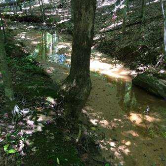
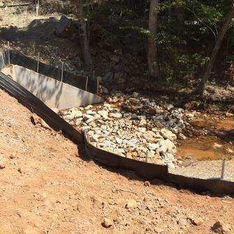
2 GENERAL COMMENTS: DEQ staff (Eric Millard, Paul Demarsh, Duston Staton) performed a joint VWP/Stormwater Construction site inspection on August 22, 2016 at 10 AM. DEQ staff met with Ricky Woody (RK&K), Paul Rash (Lane/Corman), Mark Graham (VDOT), Dave Covington (VDOT), among others. The site inspection was in response to a notification received from Ricky Woody on August 11, 2016 that indicated downstream impacts associated with sediment were observed on July 30 and 31, Impact area #1: No impacts were permitted in this area for the span crossing of the South Fork Rivanna River. DEQ staff observed this area to ensure no unpermitted impacts to avoided waters had occurred. DEQ staff recommends that the piling constructed closest to the avoided wetlands be returned to grade following construction to prevent draining of avoided wetlands. GENERAL NON-COMPLIANCE ITEMS NOTED: Impact area #2: Impacts associated with a culvert crossing for road. The stream below the culvert installation was observed to have measurable sediment for at least 200 linear feet below crossing. Impact area #3: The upstream and downstream culvert is not countersunk a minimum of 6 inches. The permittee has indicated that the lack of countersinking is due to incomplete construction of the inlet and outlet protection. Once inlet and outlet protection has been completed and the low flow channel has been constructed, the culvert will be appropriately countersunk. Impact area #4: The upstream culvert is not countersunk a minimum of 6 inches. The permittee has indicated that the lack of countersinking is due to incomplete construction of the inlet protection. Once inlet protection has been completed and the low flow channel has been constructed, the culvert will be appropriately countersunk. The erosion and sediment controls adjacent to the upstream culvert section required maintenance. The downstream culvert and stream section below the culvert leading offsite was observed to be completely inundated. The permittee indicated that this is likely due to the downstream neighbor stream crossing has been clogged creating the inundation. The permittee has attempted to contact the downstream property owners with no response. Impact area #5: The downstream culvert is not countersunk a minimum of 6 inches. The permittee has indicated that the lack of countersinking is due to incomplete construction of the
3 inlet protection. Once inlet protection has been completed and the low flow channel has been constructed, the culvert will be appropriately countersunk. The upstream culvert was not observed. Measurable sediment was observed in the stream channel approximately 300 linear feet below the downstream culvert. DEQ staff observed measurable sediment in the stream to a point approximately adjacent to Flag 263. Impact area #6: The upstream and downstream culvert is not countersunk a minimum of 6 inches. The permittee has indicated that the lack of countersinking is due to incomplete construction of the inlet and outlet protection. Once inlet and outlet protection has been completed and the low flow channel has been constructed, the culvert will be appropriately countersunk. Measurable sediment was observed in the stream channel approximately 200 linear feet below the downstream culvert. DEQ staff observed measurable sediment in the stream to a point approximately adjacent to Flag FF33. Impact area #7: The downstream culverts are not countersunk a minimum of 6 inches for both the larger stream section (Identified as USM G) and the smaller stream section (identified as USM E). The permittee has indicated that the lack of countersinking is due to incomplete construction of the inlet protection. Once inlet protection has been completed and the low flow channel has been constructed, the culvert will be appropriately countersunk. The upstream culverts were not observed. The small stream section discharges at the wing wall of the downstream structure. The small stream section outlet is approximately 1 foot higher than the stream channel. The existing rip rap outlet protection was observed to be full of sediment. The permittee has indicated that they will attempt to seed this area and establish vegetation adjacent to the stream channel. Measurable sediment was observed in the stream channel approximately 30 linear feet below the downstream culvert. DEQ staff also observed sediment below the main stormwater BMP northeast of the downstream culvert. The silt fence at the bottom of the stormwater BMP slope appeared to have been overtopped by sediment. DEQ staff observed measurable sediment in the stream channel below that point for approximately 800 linear feet. DEQ staff observed measurable sediment in the stream to a point approximately adjacent to Flag Impact area #8: Measurable sediment was observed in the stream channel approximately 700 linear feet below the downstream culvert. The permittee had already removed sediment in the stream channel prior to the site visit to a point approximately 200 linear feet below the downstream culvert. DEQ staff observed measurable sediment in the stream to a point
4 approximately adjacent to the DEQ wetland mitigation site for the Hollymead Town Center project. The entire length of stream channel where measureable sediment was observed was located in a DEQ stream mitigation area. The additional unpermitted impacts to surface waters were discovered on July and DEQ was notified on August 11, Permit Part I.G.5. requires DEQ to be notified within 24 hours of discovering impacts to surface waters that are not authorized by the permit. The notification shall include photographs, estimated acreage and/or linear footage of impacts, and a description of the impacts. VWP INPSECTOR:
5 IMPACTS MAP


6 PHOTOGRAPHS Photo 2: Impact area 1-North side of SF Rivanna at E&SC measures; Orientation: SW Photo 1: Impact area 1 looking from south side of SF Rivanna River; Orientation: NE Photo 4: Impact area 1-looking at pilings next to avoided wetlands; Orientation: N Photo 3: Impact area 1-Looking at avoided wetlands; Orientation: E


7 Photo 6: Impact area 1-looking at avoided wetland area; Orientation: N Photo 5: Impact area 1-looking at avoided wetland area; Orientation: E Photo 7: Impact area 2-looking at outlet from SWM BMP; Orientation: SW Photo 8: Impact area 2-looking at culvert; Orientation: SW


8 Photo 9: Impact area 2-stream channel below SWM BMP outlet (~300 lf of stream channel impacts observed); Orientation: SW Photo 10: Impact area 2-looking downstream. Measureable sediment observed; Orientation: W Photo 12: Impact area 3-looking upstream of culvert inlet; Orientation: NW Photo 11: Impact area 3-looking at culvert inlet; Orientation: SE


9 Photo 13: Impact area 3-looking at culvert outlet; Orientation: NW Photo 14: Impact area 3-looking downstream from culvert outlet; Orientation: SE Photo 15: Impact area 4-looking at culvert inlet; Orientation: E Photo 16: Impact area 4-looking upstream of culvert inlet; Orientation: NE


10 Photo 17: Impact area 4-looking at the downstream culvert outlet area; Orientation: S Photo 18: Impact area 4-looking at culvert outlet; Orientation: SW Photo 19: Impact area 4-backwater condition created by downstream clogged culvert crossing; Orientation: SE Photo 20: Impact area 5-looking at culvert outlet; Orientation: NW


11 Photo 21: Impact area 5-measureable sediment observed in downstream channel (~300 lf of stream channel impacts observed); Orientation: SE Photo 22: Impact area 5- measureable sediment observed in downstream channel; Orientation: SE Photo 23: Impact area 5- measureable sediment observed in downstream channel; Orientation: SE Photo 24: Impact area 5-measureable sediment observed in downstream channel; Orientation: SE


12 Photo 25: Impact area 6-looking upstream of culvert inlet; Orientation: NW Photo 26: Impact area 6-looking at culvert inlet; Orientation: E Photo 27: Impact area 6-looking at culvert outlet; Orientation: NE Photo 28: Impact area 6-measureable sediment observed in downstream channel(~200 lf of stream channel impacts observed); Orientation: SE

; Orientation: W Photo 31:")
; Orientation: N Photo 32: Impact")

13 Photo 29: Impact area 6-measureable sediment observed in downstream channel; Orientation: SE Photo 30: Impact area 7-looking at larger stream culvert outlet (USM G); Orientation: W Photo 31: Impact area 7-looking at smaller stream culvert outlet (USM E); Orientation: N Photo 32: Impact area 7-looking downstream just below culvert outlet pipes (~30 lf of stream channel impacts observed); Orientation: NE


14 Photo 33: Impact area 7-looking below SWM BMP; Orientation: NE Photo 34: Impact area 7-looking below SWM BMP on NE side of silt fence leading toward channel; Orientation: NE Photo 35: Impact area 7-measurable sediment observed in stream channel below SWM BMP (~800 lf of stream channel impacts observed); Orientation: NE Photo 36: Impact area 7-measurable sediment observed in stream channel below SWM BMP; Orientation: NE


15 Photo 37: Impact area 7-measurable sediment observed in stream channel below SWM BMP; Orientation: NE Photo 38: Impact area 7-measurable sediment observed in stream channel below SWM BMP; Orientation: NE Photo 39: Impact area 7-measurable sediment observed in stream channel below SWM BMP; Orientation: NE Photo 40: Impact area 7-measurable sediment observed in stream channel below SWM BMP; Orientation: NE


16 Photo 41: Impact area 7-measurable sediment observed in stream channel below SWM BMP; Orientation: NE Photo 42: Impact area 7-measurable sediment observed in stream channel below SWM BMP; Orientation: NE Photo 43: Impact area 7-measurable sediment observed in stream channel below SWM BMP; Orientation: NE Photo 44: Impact area 8-looking at culvert outlet; Orientation: E

;")


17 Photo 45: Impact area 8-looking at culvert outlet; Orientation: NE Photo 46: Impact area 8-looking downstream from culvert outlet (~200 lf of sediment in stream channel removed prior to inspection); Orientation: S Photo 47: Impact area 8-looking downstream, measureable sediment observed (~500 lf of stream channel impacts observed); Orientation: S Photo 48: Impact area 8-walking downstream measureable sediment observed; Orientation: W


18 Photo 49: Impact area 8-walking downstream measureable sediment observed; Orientation: W Photo 50: Impact area 8-looking from top of crossing down at culvert inlet; Orientation: NW
Suitable Applications Check dams may be appropriate in the following situations: To promote sedimentation behind the dam.
 Categories EC Erosion Control SE Sediment Control TC Tracking Control WE Wind Erosion Control Non-Stormwater NS Management Control Waste Management and WM Materials Pollution Control Legend: Primary Category
FINAL REPORT. Yonkers Creek Migration Barrier Removal Project Wonderstump Road Del Norte County. Submitted By:
 FINAL REPORT Yonkers Creek Migration Barrier Removal Project Wonderstump Road Del Norte County Submitted By: Del Norte County Community Development Department Yonkers Creek Migration Barrier Removal Project
JAP Additional Information Sheet
 JAP Additional Information Sheet Block 15: Purpose and Need The USACE purpose of the project is to provide a safe and reliable whitewater park for the recreational public in a city park, which will provide
Sediment Basin 7E-12. Design Manual Chapter 7 - Erosion and Sediment Control 7E - Design Information for ESC Measures BENEFITS.
 7E-12 Design Manual Chapter 7 - Erosion and Sediment Control 7E - Design Information for ESC Measures Sediment Basin BENEFITS Flow Control Erosion Control Sediment Control Runoff Reduction Flow Diversion
RULES OF THE OIL AND GAS PROGRAM DIVISION OF WATER RESOURCES CHAPTER DRILLING WELLS TABLE OF CONTENTS
 RULES OF THE OIL AND GAS PROGRAM DIVISION OF WATER RESOURCES CHAPTER 0400-52-06 DRILLING WELLS TABLE OF CONTENTS 0400-52-06-.01 Drilling Equipment 0400-52-06-.03 Casingheads 0400-52-06-.02 Blowout Prevention
As temporary grade control facilities along waterways until final stabilization is established.
 Check Dams (CD) EC-12 Description Check dams are temporary grade control structures placed in drainage channels to limit the erosivity of stormwater by reducing flow velocity. Check dams are typically
Information for File # SEW
 Information for File #2014-02744-SEW Applicant: Minnesota Department of Transportation (MnDOT), District 3; c/o Mr. Robert Nibbe Corps Contact: Sarah Wingert, U.S. Army Corps of Engineers, 180 5 th Street
General Information for Culvert Design
 Design Manual Chapter 2 - Stormwater 2E - Culvert Design 2E-1 General Information for Culvert Design A. Introduction A culvert is a conduit under an embankment that transports stormwater from one side
APPENDIX C VEGETATED EMERGENCY SPILLWAY. VERSION 1.0 March 1, 2011
 APPENDIX C VEGETATED EMERGENCY SPILLWAY VERSION 1.0 March 1, 2011 [NOTE: Could use a better photo more clearly showing the emergency spillway in the context of the dam.] SECTION C-1: DESCRIPTION OF PRACTICE
INFILTRATION PRACTICE MAINTENANCE INSPECTION FORM
 Facility Number: Date: Time: Subdivision Name: Watershed: Weather: Inspector(s): Date of Last Rainfall: Amount: Inches Streets: Mapbook Location: GPS Coordinates: Property Classification: Residential 9
ROAD OCCUPANCY PERMIT APPLICATION # Damascus Township, 60 Conklin Hill Road, Damascus, PA Tel Fax
 Instructions: For a driveway access permit, fill in sections 1, 2, 3 and 4, and the appropriate drawings and sign. For a Utility access, fill in sections 1, 2, 3 and 5, and figures 1 and 3. Prepare a detailed
Indiana LTAP Road Scholar Core Course #10 Culvert Drainage. Presented by Thomas T. Burke, Jr., PhD, PE Christopher B. Burke Engineering, Ltd.
 Indiana LTAP Road Scholar Core Course #10 Culvert Drainage Presented by Thomas T. Burke, Jr., PhD, PE Christopher B. Burke Engineering, Ltd. Objectives Review culvert shapes, end sections, and materials
APPENDIX J HYDROLOGY AND WATER QUALITY
 APPENDIX J HYDROLOGY AND WATER QUALITY J-1 Technical Report on Airport Drainage, Northern Sector Airport and Ordinance Creek Watershed / Preliminary Creek Constructed Natural Channel Culvert J-2 Preliminary
Culvert Safety Inspection Report
 Culvert Safety Inspection Report Facility Federal Structure ID Inspector Name Agency/Consultant Inspection Date LEGEND Haggerty Rd (South) N/A RL/JF GLEG 1/26/2016 9 New Feature Latitude Longitude Struc
Technical Report Culvert A Hydraulic Analysis
 DATE: November 3, 2011 Technical Report Culvert A Hydraulic Analysis TO: FROM: RE: Jim Reiser, P.E. Project Manager Parsons Brinckerhoff, Inc. Kurt Killian, P.E., CFM Parsons Brinckerhoff, Inc. Design
(Revised February,2005) CULVERTS, BRIDGES, AND FORDS
 CULVERTS, BRIDGES, AND FORDS") GUIDE TO STREAM CROSSINGS (Revised February,2005) CULVERTS, BRIDGES, AND FORDS Culverts, bridges, and fords are all methods used to cross-streams. Culverts are the most common stream crossing structure.
GUIDE TO STREAM CROSSINGS (Revised February,2005) CULVERTS, BRIDGES, AND FORDS Culverts, bridges, and fords are all methods used to cross-streams. Culverts are the most common stream crossing structure.
UNDERWATER BRIDGE INSPECTION REPORT STRUCTURE NO OVER THE STRAIGHT RIVER DISTRICT 6 - RICE COUNTY
 UNDERWATER BRIDGE INSPECTION REPORT STRUCTURE NO. 66513 14 th STREET (MSAS NO. 103) OVER THE STRAIGHT RIVER DISTRICT 6 - RICE COUNTY PREPARED FOR THE MINNESOTA DEPARTMENT OF TRANSPORTATION BY COLLINS ENGINEERS,
STRUCTURAL STABILITY ASSESSMENT
 STRUCTURAL STABILITY ASSESSMENT CFR 257.73(d) Fly Ash Reservoir II Cardinal Plant Brilliant, Ohio October, 2016 Prepared for: Cardinal Operating Company Cardinal Plant Brilliant, Ohio Prepared by: Geotechnical
June 13, 2016 Tom Garigen Re: Myrtle Beach Golf and Yacht Club Drainage assessment
 INFRASTRUCTURE & REGULATION DIVISION- STORMWATER DEPARTMENT 4401 Privetts Road Conway, South Carolina 29526 Post Office Box 1236 Conway, South Carolina 29528-1236 Phone: (843) 915-5160 Fax: (843) 365-2208
UNDERWATER BRIDGE INSPECTION REPORT STRUCTURE NO CSAH 4 OVER THE BEAVER RIVER ST. LOUIS COUNTY
 UNDERWATER BRIDGE INSPECTION REPORT STRUCTURE NO. 7635 CSAH 4 OVER THE BEAVER RIVER ST. LOUIS COUNTY JUNE 18, 2012 PREPARED FOR THE MINNESOTA DEPARTMENT OF TRANSPORTATION BY COLLINS ENGINEERS, INC. JOB
King. Maureen C. Keller. Tuyen L. Tran, P.E Sr Project Manager. Trusted Professional Services Since 1977
 Maureen C. Keller From: Sent: To: Subject: Tuyen L. Tran Tuesday, May 16, 2017 11:07 AM Maureen C. Keller FW: Carlton Lakes Development : Creek Remediation Work From: Russell Martin [mailto:russell.martin@swfwmd.state.fl.us]
Chapter 11. Culverts and Bridges Design Checklist for Culvert Design
 Yes No N/A Design Requirements I. GENERAL DESIGN GUIDELINES Chapter 11. Culverts and Bridges A. Culvert design is in accordance with the Culverts chapter of Volume 2 of the UDFCD Manual for additional
UNDERWATER BRIDGE INSPECTION REPORT STRUCTURE NO MSAS 123 (2 ND AVE. SW) OVER THE CANNON RIVER CITY OF FARIBAULT, RICE COUNTY
 OVER THE CANNON RIVER CITY OF FARIBAULT, RICE COUNTY") UNDERWATER BRIDGE INSPECTION REPORT STRUCTURE NO. 66546 MSAS 123 (2 ND AVE. SW) OVER THE CANNON RIVER CITY OF FARIBAULT, RICE COUNTY SEPTEMBER 13, 2012 PREPARED FOR THE MINNESOTA DEPARTMENT OF TRANSPORTATION
UNDERWATER BRIDGE INSPECTION REPORT STRUCTURE NO. 66546 MSAS 123 (2 ND AVE. SW) OVER THE CANNON RIVER CITY OF FARIBAULT, RICE COUNTY SEPTEMBER 13, 2012 PREPARED FOR THE MINNESOTA DEPARTMENT OF TRANSPORTATION
CT EXPANSION PROJECT SILT FENCE DESIGN CRITERIA AND METHODOLOGY CONNECTICUT LOOP. Submitted by:..
 CT EXPANSION PROJECT SILT FENCE DESIGN CRITERIA AND METHODOLOGY CONNECTICUT LOOP Submitted by:.. Tennessee Gas Company L.L.C. 1001 Louisiana St, Suite 1000 Houston, TX 77002 July 2014 Revised March 2015
Eastern Brook Trout Joint Venture Annual Report The Nature Conservancy 2013
 Eastern Brook Trout Joint Venture Annual Report The Nature Conservancy 2013 2013 Annual Performance Report Enhancing Connectivity in the Ash-Black Rock Sub-basin of the West Branch Narraguagus River. Project
Beavers are particularly adept at manipulating their
 Beavers are particularly adept at manipulating their environment to suit their needs. They instinctively build dams to raise water levels and increase the area covered by water. Beaver ponds provide security
CHAPTER 5 CULVERT DESIGN
 CHAPTER 5 CULVERT DESIGN HYDRAULICS OF CULVERTS There are two major types of culvert flow: 1) flow with inlet control, and 2) flow with outlet control. For each type, different factors and formulas are
Stream Crossings I: Engineering and Design Approaches to Provide Fish Passage at Culvert Slipline Projects in Connecticut
 University of Massachusetts - Amherst ScholarWorks@UMass Amherst International Conference on Engineering and Ecohydrology for Fish Passage International Conference on Engineering and Ecohydrology for Fish
INADVERTENT RETURN PLAN FOR HORIZONTAL DIRECTIONAL DRILLING (HDD)
") INADVERTENT RETURN PLAN FOR HORIZONTAL DIRECTIONAL DRILLING (HDD) FACILITY OPERATOR: NextEra Energy Resources, LLC 700 Universe Boulevard Juno Beach, FL 33408 For Horizontal Directional Drilling Contents
INADVERTENT RETURN PLAN FOR HORIZONTAL DIRECTIONAL DRILLING (HDD) FACILITY OPERATOR: NextEra Energy Resources, LLC 700 Universe Boulevard Juno Beach, FL 33408 For Horizontal Directional Drilling Contents
TABLE OF CONTENTS LEGAL NOTICE
 Closure Plan for Existing CCR Rev. 0 Surface Impoundments Page No. i TABLE OF CONTENTS 1. INTRODUCTION AND PURPOSE... 1 2. CLOSURE PLAN NARRATIVE DESCRIPTION... 2 3. FINAL COVER SYSTEM DESCRIPTION... 3
CCR Landfill 2017 Annual Inspection Report NC1 Ash Disposal Area
 CCR Landfill 2017 Annual Inspection Report NC1 Ash Disposal Area Omaha Public Power District Nebraska City Station Nebraska City, Nebraska January 19, 2018 OPPD Nebraska City Station NC1 Ash Disposal Area
UNDERWATER BRIDGE INSPECTION REPORT STRUCTURE NO CSAH 133 OVER A DITCH ST. LOUIS COUNTY
 UNDERWATER BRIDGE INSPECTION REPORT STRUCTURE NO. 7780 CSAH 133 OVER A DITCH ST. LOUIS COUNTY SEPTEMBER 27, 2012 PREPARED FOR THE MINNESOTA DEPARTMENT OF TRANSPORTATION BY COLLINS ENGINEERS, INC. JOB NO.
UNDERWATER BRIDGE INSPECTION REPORT METRO DISTRICT - ANOKA COUNTY
 UNDERWATER BRIDGE INSPECTION REPORT STRUCTURE NO. 02545 CR NO. 116 OVER THE RUM RIVER METRO DISTRICT - ANOKA COUNTY SEPTEMBER 9, 2012 PREPARED FOR THE MINNESOTA DEPARTMENT OF TRANSPORTATION BY COLLINS
CHAPTER 4 SPALDING COUNTY, GEORGIA 4.0 CULVERT DESIGN
 SPALDING COUNTY, GEORGIA CHAPTER 4 4.0 CULVERT DESIGN... 4-1 4.1 INTRODUCTION... 4-1 4.2 SYMBOLS AND DEFINITIONS... 4-1 4.3 ENGINEERING DESIGN CRITERIA... 4-2 4.3.1 FREQUENCY FLOOD... 4-2 4.3.2 VELOCITY
Great Lakes Stream Crossing Inventory Instructions
 Great Lakes Stream Crossing Inventory Instructions This document is a guide to completing the Stream Crossing Data Sheet (2/28/11 version). Careful attention to this guidance will ensure consistent crossing
Creation of Fish and Wildlife Habitat on the Closed Salmon Harbour Mine in Minto, NB
 Creation of Fish and Wildlife Habitat on the Closed Salmon Harbour Mine in Minto, NB M. Coleman 1, R. Rutherford 2, RA Currie 3 1 NB Power 2 Thaumas Environmental Consultants Ltd 3 RA Currie Ltd. Location
City of Burnaby Environmental Review Committee (ERC) Guide for Applicants
 Guide for Applicants") City of Burnaby Environmental Review Committee (ERC) Guide for Applicants 2017-2018 This Guide summarizes the ERC process for project review including applications for a relaxation (variance) to the development
City of Burnaby Environmental Review Committee (ERC) Guide for Applicants 2017-2018 This Guide summarizes the ERC process for project review including applications for a relaxation (variance) to the development
Whitewater Valley Station Surface Impoundment Coal Combustion Residual Annual Report
 Whitewater Valley Station Wayne County, Indiana GAI Project Number: C151119.07 July 2017 Prepared by: GAI Consultants, Inc. Murrysville Office 4200 Triangle Lane Export, Pennsylvania 15632-1358 Prepared
Green CCR Surface Impoundment
 Green CCR Surface Impoundment Disposal of Coal Combustion Residuals (CCR) from Electric Utilities Final Rule CCR Impoundment 2017 Annual Inspection Report January 11, 2018 Prepared By: Project ID: 170138A
Storm Damage Floating Culverts & Other Inlet Issues
 Storm Damage Floating Culverts & Other Inlet Issues Mark Bailey, PE - Hydraulic Manager, INDOT Dale Sedler, PE - Sr. Hydraulic Engineer, INDOT Road School 2016 What causes a culvert to float? 1. Accumulation
Site Diary Campus Drive Relocation Project. Noboru Togawa. Presented to: Dr. Pitt Construction Site Erosion Control
 Site Diary Campus Drive Relocation Project by Presented to: Dr. Pitt Construction Site Erosion Control Department of Civil, Construction, and Environmental Engineering The University of Alabama Tuscaloosa,
D.B. Wilson Station CCR Landfill
 D.B. Wilson Station CCR Landfill Disposal of Coal Combustion Residuals (CCR) from Electric Utilities Final Rule Closure and Post-closure Care Plan October 11, 2016 Prepared By: Project ID: 160030A Big
HY-8 Version 7.2 Build Date January 17, Federal Highway Administration.
 HY-8 Version 7.2 Build Date January 17, 2012 Federal Highway Administration http://www.fhwa.dot.gov/engineering/hydraulics/software/hy8/index.cfm SIMPLE Simple to use Use for simple culverts and bridges
Water Resources Report RKLD Annual Meeting July 30, 2016
 Water Resources Report RKLD Annual Meeting 2016 July 30, 2016 Topics Hydrology Report Indianford Dam trash rack cleanout performance Experimental Project update Review of PAS project Twin floods- 1 to
FEDERAL ENERGY REGULATORY COMMISSION FIELD INSPECTION REPORT
 FIELD INSPECTION REPORT Date September 25 and 26, 2016 Project Kern River Gas Transmission Company (Kern River) Apex Expansion Project Utah, Millard, Beaver, Morgan, Davis, and Salt Lake Counties, Utah;
PRELIMINARY STORM DRAINAGE REPORT
 PRELIMINARY STORM DRAINAGE REPORT DRURY LANE DEVELOPMENT 704 1ST STREET SULTAN, WA 98294-94240 PARCEL #28083200305500 AUDITOR S FILE NO. 1090255 CITY OF SULTAN SNOHOMISH COUNTY, WASHINGTON PREPARED FOR:
Project Completion Abstract Fish Passage Activity ( Engineering Activities)
") Project Completion Abstract Fish Passage Activity ( Engineering Activities) SUBMIT COMPLETED FORM TO DISTRICT MANAGER AND FIA ADMINISTRATOR AFTER PROJECT COMPLETION SECTION A GENERAL INFORMATION Recipient:
Project Completion Abstract Fish Passage Activity ( Engineering Activities) SUBMIT COMPLETED FORM TO DISTRICT MANAGER AND FIA ADMINISTRATOR AFTER PROJECT COMPLETION SECTION A GENERAL INFORMATION Recipient:
RLRC COMMUNITIES EAST GRAND FORKS AREA CHARACTER THE RED LAKE RIVER & THE RED RIVER OF THE NORTH CONFLUENCE EAGLE POINT BOAT LAUNCH DESIGN
 AREA CHARACTER THE RED LAKE RIVER & THE RED RIVER OF THE NORTH CONFLUENCE EAGLE POINT BOAT LAUNCH DESIGN DESIGN DETAILS 135 AREA CHARACTER East Grand Forks a city of 7,501 people is located across the
Culvert Design An Overview of the NYS Highway Design Manual Chapter 8
 Seventeenth Statewide Conference on Local Bridges Culvert Design An Overview of the NYS Highway Design Manual Chapter 8 Tuesday, October 25, 2011 Training Session: Culvert Design, Analysis - talk 2 Presented
U.S. Army Corps of Engineers Sacramento District
 U.S. Army Corps of Engineers Sacramento District Regional General Permit (RGP) 3 Pre-Construction Notification (PCN) Form This form may be used to request verification for a small, private, recreational
Trout Buffer Variance
 Trout Buffer Variance Ashley L. Rodgers, PE Spring 2015 Why a Trout Buffer Capturing pollutants in runoff to keep the water clean. Capturing sediment to keep mud out of the water. Providing shade to keep
ANNUAL INSPECTION BY A QUALIFIED PROFESSIONAL ENGINEER ALL CCR IMPOUNDMENTS CCR Rule Section (b)
") ANNUAL INSPECTION BY A QUALIFIED PROFESSIONAL ENGINEER ALL CCR IMPOUNDMENTS ASBURY POWER PLANT 21133 Uphill Lane Asbury, Missouri 64832 January 18, 2019 LIBERTY UTILITIES Empire District Prepared by: Rachel
ANNUAL INSPECTION BY A QUALIFIED PROFESSIONAL ENGINEER ALL CCR IMPOUNDMENTS ASBURY POWER PLANT 21133 Uphill Lane Asbury, Missouri 64832 January 18, 2019 LIBERTY UTILITIES Empire District Prepared by: Rachel
USING A LABYRINTH WEIR TO INCREASE HYDRAULIC CAPACITY. Dustin Mortensen, P.E. 1 Jake Eckersley, P.E. 1
 USING A LABYRINTH WEIR TO INCREASE HYDRAULIC CAPACITY Dustin Mortensen, P.E. 1 Jake Eckersley, P.E. 1 Plum Creek Floodwater Retarding Structure No. 6 is located in an area of Kyle, Texas, that is currently
UNDERWATER BRIDGE INSPECTION REPORT DISTRICT 1 PINE COUNTY
 UNDERWATER BRIDGE INSPECTION REPORT STRUCTURE NO. 58551 CSAH NO. 41 OVER THE KETTLE RIVER DISTRICT 1 PINE COUNTY JULY 28, 2012 PREPARED FOR THE MINNESOTA DEPARTMENT OF TRANSPORTATION BY COLLINS ENGINEERS,
CLEANING, INSPECTION, AND TESTING OF SEWERS
 CLEANING, INSPECTION, AND TESTING OF SEWERS PART 1 - GENERAL 1.01 SECTION INCLUDES A. Cleaning, Inspecting, and Testing Sanitary Sewers B. Cleaning, Inspecting, and Testing Storm Sewers C. Cleaning and
Photo 1: Typical 4 Weephole
 April 25, 2008 MEMORANDUM To: Shelly LeClaire Milford Highway Department From: Tom Jenkins, P.E. Baystate Environmental Consultants, Inc. RE: Results of Field Inspection of Charles River Culvert Potential
Illinois State Water Survey
 Illinois State Water Survey HYDROLOGY DIVISION SWS Contract Report 508 COMPARISON OF 1987 AND 1989 BED PROFILE SURVEYS OF THE LOWER CACHE RIVER by Richard Allgire Office of Sediment and Wetland Studies
Hard Hat Services ph: hardhatinc.com 932 N. Wright St., Suite 160 Naperville, IL 60563
 Interstate Power and Light Company Ottumwa Generation Station CCR Surface Impoundment Annual Inspection Report 154.018.012.003 Report issued: December 21, 2016 Hard Hat Services ph: 877-630-7428 hardhatinc.com
Hard Hat Services ph: hardhatinc.com 932 N. Wright St., Suite 160 Naperville, IL 60563
 Interstate Power and Light Company Ottumwa Generation Station CCR Surface Impoundment Annual Inspection Report 154.018.015.003 Report issued: July 03, 2017 Hard Hat Services ph: 877-630-7428 hardhatinc.com
FINAL HARRIS CHAIN OF LAKES RESTORATION COUNCIL SITE VISIT SUMMARY. of the. Projects Tour March 3, 2006
 FINAL HARRIS CHAIN OF LAKES RESTORATION COUNCIL SITE VISIT SUMMARY of the Projects Tour March 3, 2006 The regular meeting of the Harris Chain of Lakes Restoration Council (Council) was cancelled to facilitate
If you have comments on this or suggestions for other terms that should be added to this glossary, please send an to
 Tide Gates Glossary There is very little information available anywhere related to tide gates and flap gates. This is a glossary of terms that are associated with, or useful when discussing, tide gates.
Shovelnose Creek Off-Channel Complex Berm Repair
 Shovelnose Creek Off-Channel Complex Berm Repair Recent high discharge events have put valuable off-channel salmonid rearing and spawning habitat at risk in the upper Squamish River. This document is a
Estimated on-the-ground start and end dates: 1 June October 2018
 A. Applicant Information Name of Organization: U.S. Army Corps of Engineers, Carlyle Lake 801 Lake Road, Carlyle, IL 62231 Contact Information: Robert Wilkins, Operations Manager, (618) 594-2484, Robert.Wilkins@usace.army.mil
RESTORING THE CONNECTION BETWEEN CREEK AND LAKE: FRESH WATER ESTUARINE CREATION IN MISSISSAUGA
 RESTORING THE CONNECTION BETWEEN CREEK AND LAKE: FRESH WATER ESTUARINE CREATION IN MISSISSAUGA Jeff Doucette, Kenneth Dion and Sally-Beth Betts 6 th International Conference on Natural Channel Systems
City of Guelph. Hanlon Creek Business Park Stormwater Management Report Ponds 1, 2, 3 and 4
 City of Guelph Hanlon Creek Business Park Stormwater Management Report Ponds 1, 2, 3 and 4 City of Guelph Hanlon Creek Business Park Stormwater Management Report Ponds 1, 2, 3 and 4 Prepared by: AECOM
Definitions as used in this Subchapter:
 21-2 Streets and Sidewalks 21-2 STORM WATER. 21-2.01 Definitions as used in this Subchapter: The terms as used in this Subchapter are further defined in the City of Bowling Green Stormwater Best Management
ADDENDA B Hydrologic and Hydraulic (H&H) Study Guidance 2019
 Study Guidance 2019") 09/25/2018 DRAFT FEMA Region I PA H&H Study ADDENDA B Hydrologic and Hydraulic (H&H) Study Guidance 2019 Region I Federal Emergency Management Agency (FEMA) Public Assistance Hydrologic and Hydraulic (H&H)
09/25/2018 DRAFT FEMA Region I PA H&H Study ADDENDA B Hydrologic and Hydraulic (H&H) Study Guidance 2019 Region I Federal Emergency Management Agency (FEMA) Public Assistance Hydrologic and Hydraulic (H&H)
NWS 44: Mining Activities Location #1, Stanislaus River
 NWS 44: Mining Activities Location #1, Stanislaus River Permit is for the use of a single 8 dredge on a federal mining claim at the location described on the map and as Twp 02N Range 14E, Section 04, MDM
CITY OF ROSEVILLE DESIGN STANDARDS
 CITY OF ROSEVILLE DESIGN STANDARDS Section 1 Purpose and Definitions 1-1 Purpose PD 1 1-2 Design Practice PD 1 1-3 Definitions PD 1 Section 2 General Requirements 2-1 Plans by an Appropriate Engineer GR
Joe Rathbun Michigan DEQ Water Resources Division Nonpoint Source Unit * Thanks to The Nature Conservancy
 Joe Rathbun Michigan DEQ Water Resources Division Nonpoint Source Unit rathbunj@mi.gov * Thanks to The Nature Conservancy Road-stream intersections = 67,511 Culverts = 60,700 Bridges = 6,811 Perched Piping
Assessment of Soil Erosion at a DC Park Facility Spring Valley Park NW Washington, DC
 Assessment of Soil Erosion at a DC Park Facility Spring Valley Park NW Washington, DC Annual Progress Report for FY 2004 Prepared by: Principal Investigators: Inder Bhambri, Ph.D., PE Philip Brach, Ph.D.,
UNDERWATER BRIDGE INSPECTION REPORT DISTRICT 8 - LAC QUI PARLE COUNTY
 UNDERWATER BRIDGE INSPECTION REPORT STRUCTURE NO. 6391 CSAH NO. 33 OVER THE MINNESOTA RIVER DISTRICT 8 - LAC QUI PARLE COUNTY OCTOBER 22, 2012 PREPARED FOR THE MINNESOTA DEPARTMENT OF TRANSPORTATION BY
River Restoration: Culvers Island weir removals and river naturalisation project.
 River Restoration: Culvers Island weir removals and river naturalisation project. Background Chalk streams are an incredibly rare habitat on a global scale, and owing to their international importance,
Introduction to Check Dams
 Introduction to Check Dams Kabul, Afghanistan February 2011 3 This watershed rehabilitation and restoration training was prepared by the U.S. Department of Agriculture (USDA) team of Jon Fripp (Civil Engineer
RESPONSE TO COMMENT: 45
 45 a. 45 b. RESPONSE TO COMMENT: 45 California State Lands Commission (Stephen L. Jenkins) 45-a: The comment states that the State Lands Commission will not require a lease at this time but may require
Illinois Lake Management Association Conference March 23, 2018 By Trent Thomas Illinois Department of Natural Resources Division of Fisheries
 Illinois Lake Management Association Conference March 23, 2018 By Trent Thomas Illinois Department of Natural Resources Division of Fisheries Sources of Habitat Impairment Sedimentation Channelization
Project Report for Marsh Creek and Albion River Instream Fish Barrier Removal Flynn Creek Road, CR 135, M.P. 8.1 and 8.3
 Project Report for Marsh Creek and Albion River Instream Fish Barrier Removal Flynn Creek Road, CR 135, M.P. 8.1 and 8.3 Project Title: Marsh Creek and Albion River Instream Fish Barrier Removal, Flynn
3.0 Basin and Watershed Characteristics
 3.0 Basin and Watershed Characteristics 3.1 Basin Characteristics 3.1.1 Crystal Lake Crystal Lake, located in the cities of Burnsville and Lakeville (Dakota County), covers an area of approximately 292
SAFE WALKS PROGRAM FREQUENTLY ASKED QUESTIONS
 SAFE WALKS PROGRAM FREQUENTLY ASKED QUESTIONS Why does the City have a Safe Walks Program? The Safe Walks program was initiated in 2006 at the request of City Council in order to address the increasing
Becker* Products Below Ground Ball Valve Regulators
 GE Oil & Gas Becker* Products Below Ground Ball Valve Regulators Reduce Noise Levels at Large Volume Regulator Stations GE s Becker* Below Ground ball valve regulator has the long-term proven reliability,
Initial Annual CCR Landfill Inspection OML Existing Landfill OML Expansion Phase 1
 Initial Annual CCR Landfill Inspection OML Existing Landfill OML Expansion Phase 1 Ottumwa-Midland Landfill Prepared for: Ottumwa-Midland Landfill 15300 130 th Street Ottumwa, Iowa 52501 Prepared by: SCS
Stephens Creek Culvert Replacement. CAC April 28, 2010
 Stephens Creek Culvert Replacement CAC April 28, 2010 1 Top of Bank Willamette Moorage Park Existing Culverts 50 ft Greenway Setback 200 ft Greenway Setback Existing Macadam Bay Access Stephens Creek Existing
MEETING CALLED TO ORDER: THOSE PRESENT: EXCUSED: GUESTS: 310 INSPECTION REPORTS ~ READY FOR DECISION:
 MEETING CALLED TO ORDER: THOSE PRESENT: EXCUSED: GUESTS: 310 Agenda: 310 INSPECTION REPORTS ~ READY FOR DECISION: Inspection Date 3 /17/2016 Application Number GD-009-16 Applicant Longmire Court Holdings,
UNDERWATER BRIDGE INSPECTION REPORT STRUCTURE NO CSAH NO. 7 OVER THE SNAKE RIVER DISTRICT 1 - PINE COUNTY
 UNDERWATER BRIDGE INSPECTION REPORT STRUCTURE NO. 58506 CSAH NO. 7 OVER THE SNAKE RIVER DISTRICT 1 - PINE COUNTY PREPARED FOR THE MINNESOTA DEPARTMENT OF TRANSPORTATION BY COLLINS ENGINEERS, INC. JOB NO.
Little Traverse Bay Watershed Road/Stream Crossing Inventory
 Little Traverse Bay Watershed Road/Stream Crossing Inventory Completed by Tip of the Mitt Watershed Council with support from: Petoskey-Harbor Springs Area Community Foundation s Little Traverse Bay Protection
Climate Change Adaptation and Stream Restoration. Jack Williams;
 Climate Change Adaptation and Stream Restoration Jack Williams; jwilliams@tu.org 1 Goals for this presentation Develop strategies for adapting streams to climate impacts by Thinking like a watershed Understanding
January 25, Franklin Pasture Sanitary Sewer Cure-In-Place Pipe Lining Bid No Bid Date: 2/7/17 ADDENDUM NO 1
 PUBLIC WORKS DEPARTMENT David A. Jones, P.E., Director January 25, 2017 Franklin Pasture Sanitary Sewer Cure-In-Place Pipe Lining Bid. 2017-005 Bid Date: 2/7/17 ADDENDUM NO 1 SPECIFICATION REVISIONS: QUESTIONS
Low Gradient Velocity Control Short Term Steep Gradient Channel Lining Medium-Long Term Outlet Control Soil Treatment Permanent [1]
![Low Gradient Velocity Control Short Term Steep Gradient Channel Lining Medium-Long Term Outlet Control Soil Treatment Permanent [1]](/thumbs/80/80811988.jpg "Low Gradient Velocity Control Short Term Steep Gradient Channel Lining Medium-Long Term Outlet Control Soil Treatment Permanent [1]") Check Dams DRAINAGE CONTROL TECHNIQUE Low Gradient Velocity Control Short Term Steep Gradient Channel Lining Medium-Long Term Outlet Control Soil Treatment Permanent [1] [1] Though not generally considered
Check Dams DRAINAGE CONTROL TECHNIQUE Low Gradient Velocity Control Short Term Steep Gradient Channel Lining Medium-Long Term Outlet Control Soil Treatment Permanent [1] [1] Though not generally considered
Notice of Intent to Close Inactive CCR Surface Impoundments
 Notice of Intent to Close Inactive CCR Surface Impoundments Virginia Electric and Power Company Possum Point Power Station Coal Combustion Residual Surface Impoundments A, B, C, D, and E Dumfries, Virginia
CITY OF SALEM DEPARTMENT OF PUBLIC WORKS STANDARD DRAWINGS TABLE OF CONTENTS
 001-099 100-199 200-299 Stormwater 300-399 400-499 500-599 600-699 700-799 800-899 Miscellaneous Sewers and Drains Streets Water Structures Earthwork Street Lighting and Traffic Signals Landscape and Irrigation
Five Counties Salmonid Conservation Program - Fish Passage Design Workshop. February 2013
 Program - Aquatic Organisms and Stream Crossings Ecological Connectivity A watershed is a network of channels that drain a common boundary. Channel characteristics formed by interaction of precipitation,
Schedule for Culvert Works in or on the Bed or Bank of a Watercourse PLEASE READ THIS PAGE BEFORE COMPLETING THE APPLICATION FORM
 10A Schedule for Culvert Works in or on the Bed or Bank of a Watercourse This form is to be used for applications to use, erect, place, extend, alter or replace a culvert in or on the beds or banks of
ANNUAL INSPECTION BY A QUALIFIED PROFESSIONAL ENGINEER ALL CCR IMPOUNDMENTS CCR Rule Section (b)
") ANNUAL INSPECTION BY A QUALIFIED PROFESSIONAL ENGINEER ALL CCR IMPOUNDMENTS ASBURY POWER PLANT 21133 Uphill Lane Asbury, Missouri 64832 January 18, 2017 EMPIRE DISTRICT ELECTRIC COMPANY Prepared by: Rachel
ANNUAL INSPECTION BY A QUALIFIED PROFESSIONAL ENGINEER ALL CCR IMPOUNDMENTS ASBURY POWER PLANT 21133 Uphill Lane Asbury, Missouri 64832 January 18, 2017 EMPIRE DISTRICT ELECTRIC COMPANY Prepared by: Rachel
Hospital Link Project Project Update November 2017
 Hospital Link Project Project Update November 2017 General The project provides a link from Riverside Drive and the Transitway to the Hospital Link Road. Construction is well underway. Read on for important
OFFICE OF STRUCTURES MANUAL FOR HYDROLOGIC AND HYDRAULIC DESIGN CHAPTER 13 CULVERTS APRIL 2011
 OFFICE OF STRUCTURES MANUAL FOR HYDROLOGIC AND HYDRAULIC DESIGN CHAPTER 13 CULVERTS APRIL 2011 APRIL 2011 Chapter 13 Culverts Table of Contents Foreword.3 13.1 Introduction.. 4 13.2 Policy 6 13.3 Passage
HEC 26 Aquatic Organism Passage Design Manual Evolution & Application
 HEC 26 Aquatic Organism Passage Design Manual Evolution & Application Sven Leon, P.E., Hydraulics Engineer Federal Highway Administration 2015 Alaska Fish Passage Meeting October 13 14, 2015 VTRC, Juneau,
Northern Indiana Public Service Company Michigan City Generating Station Primary Settling Pond Number Annual RCRA CCR Unit Inspection Report
 REPORT Northern Indiana Public Service Company Michigan City Generating Station Primary Settling Pond Number 2 2018 Annual RCRA CCR Unit Inspection Report Submitted to: Northern Indiana Public Service
Culvert Design for Low and High Gradient Streams in the Midwest. Dale Higgins, Hydrologist Chequamegon-Nicolet National Forest
 Culvert Design for Low and High Gradient Streams in the Midwest Dale Higgins, Hydrologist Chequamegon-Nicolet National Forest Overview Culvert Design Considerations Hydraulic Terms Culvert Impacts Low
Earthen Embankments. turning into larger, more costly repairs. The following. The State Dam Safety Program has inspection
 TOPIC: COMMON PROBLEMS FOR SMALL DAMS WITH CONCRETE CHANNEL SPILLWAYS The State Dam Safety Program has inspection requirements for state regulated dams. A dam, like any man-made structure, will change
Final Fish Salvage & Temporary Tailrace Barrier Report for the Wallowa Falls Hydroelectric Project Tailrace. (FERC No. P-308) December 20, 2018
 December 20, 2018") Final Fish Salvage & Temporary Tailrace Barrier Report for the Wallowa Falls Hydroelectric Project Tailrace (FERC No. P-308) December 20, 2018 Prepared by: Jeremiah Doyle PacifiCorp 825 NE Multnomah Street
Final Fish Salvage & Temporary Tailrace Barrier Report for the Wallowa Falls Hydroelectric Project Tailrace (FERC No. P-308) December 20, 2018 Prepared by: Jeremiah Doyle PacifiCorp 825 NE Multnomah Street