Exploration and Mine Site Model Applied to Seamount Lease-Block Selection for Cobalt-Rich Crusts. James R. Hein U.S. Geological Survey For the ISA
|
|
|
- Camron Gardner
- 5 years ago
- Views:
Transcription

1 Exploration and Mine Site Model Applied to Seamount Lease-Block Selection for Cobalt-Rich Crusts James R. Hein U.S. Geological Survey For the ISA

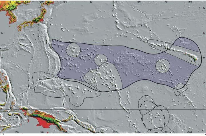
2 Introduction Parameters that ultimately will be used to define an exploration area and mine site are unknown Reasonable assumptions are used to bracket likely characteristics A set of conditions is selected based on present state-of-knowledge of seamount morphology and size, and distribution of cobalt-rich crusts
3 Rationale for seamount selection parameters Mining operations will take place around the summit region of guyots on flat or shallowly inclined surfaces: summit platforms, terraces, and saddles These are the areas with the thickest and most cobalt-rich crusts Much thinner crusts occur on steep slopes Conical seamounts are too small, with rugged summits Seamount summits will not be much deeper than about 2200 m; terraces will not be deeper than about 2500 m Slopes are more rugged below 2500 m Crusts are thinner below 2500 m The contents of Co, Ni, Cu, etc. in crusts are less below 2500 m Little or no sediment will occur on the summit platform, therefore, a region of strong and persistent bottom currents
4 Rationale (continued) The summit region above 2500 m will be large, more than 400 km 2 Yields fewest seamounts needed to be mined The submarine flanks of islands and atolls will not be considered for mining Clusters of large seamounts will be favoured The seamounts will be old, of Cretaceous age Crust thickness, slope stability, guyots with large summit areas Seamounts with thick crusts and high grades (Co, Ni, Cu, etc.) The central Pacific best fulfills all these criteria
5
6 Area calculation details Surface area of 34 typical seamounts calculated ArcMap s 3-D analyst used for area calculations Sediment vs. hard-rock calculated from side-scan sonar back-scatter images


7 56 kilometers long Terraces: smooth and rough Large area above 2500 m Debris apron Typical Guyot
8 14 slopes Small area above 2,500 m Rugged summit Typical Conical Seamount
9 Total surface area of 19 Central Pacific Guyots Km 2 Km ,800 1,600 1,400 1,200 1, , Total surface area of 34 seamounts: 62,250 km 2 Geographic area hosting 34 seamounts: 506,000 km 2 25 km 2 /yr mining area 500 km 2 /20 yrs mining site 2,500 km 2 for exploration for mine sites Total Surface Area of 15 Central Pacific Conical Seamounts
10 Total Surface Area of 19 Guyots above 2500 m water depth Total Surface Area of 15 Conical Seamounts above 2500 m water depth Km Km Total surface area of 34 seamounts above 2500 m: 17,470 km 2 25 km 2 /yr mining area 500 km 2 /20 yrs mining site 2,500 km 2 for exploration for mine sites
11 Average Seamount (Surface Area Statistics for 34 Seamounts) Total Surface Area (km 2 ) Surface Area above 2500m water depth (km 2 ) Mean 1, Median 1, SD 1 1, Minimum Maximum 4,775 1,843 1 Standard Deviation 25 km 2 /yr mining area 500 km 2 /20 yrs mining area 2,500 km 2 for exploration for mine sites
 Other impediments to")
12 Actual surface area to be mined limited by: Crust exposure/sediment cover Varies from nearly 0% to nearly 100% Cut-off of 60% sediment cover, seamount size dependent Worst case scenario: 60% reduction leaves 528 km 2 for largest seamount in data set (1,254 km 2 for 5% cover) Other impediments to mining

13 Other Impediments to Mining Prohibitive smallscale topography Biological corridors Unforeseen impediments Up to 70% further reduction in mining area Worst case scenario: 70% reduction leaves 158 square kilometers available for the largest seamount in data set (376 square kilometers for 5% sediment cover)
14 Reduction in Mineable Area
15 Crust thickness and square meter tonnage Worst case: mean crust thickness of 2 cm = 39 kg/m 2 wet weight (density 1.95 g/cm 3 ) Best case: mean crust thickness of 6 cm = 117 kg/m 2 Model mine site: 2.5 cm net thickness = kg/m 2 Areas have been found with a mean crust thickness of 14 cm = an incredible 273 kg of Corich crusts per m 2 of seabed
16 Number of seamounts Based on our data set of 34 measured seamounts: 1.1 to 2.6 large guyots or average-size seamounts needed for 20-year mining project A single larger seamount could sustain a 20-year mining operation under favorable conditions Large guyots with little sediment cover, subdued topography, and average crusts of >2.5 cm are most likely to be mined, all of which would reduce the number of seamounts needed for a 20-year mine site
17 Selection of Lease-Block Size and Exploration Area Recommended exploration lease-block size is 100 km 2 The 100 km 2 blocks are composed of contiguous 20 km 2 sub-blocks 100 km 2 exploration blocks need not be contiguous The sub-block size should be small enough to ensure nearly continuous crust coverage within the sub-block
18 The exploration lease is defined as twenty-five 100 km 2 blocks, yielding 2,500 km 2 for exploration Relinquishment of unwanted territory will proceed using the 20 km 2 sub-blocks 20 km 2 sub-blocks will be relinquished during 2 or 3 phases as unfavorable areas are identified A final 25 sub-blocks will be chosen for a 20- year mine site of 500 km 2 ; on one seamount or portioned among two or more seamounts
19 Summary of Exploration/Mine Blocks Twenty-five 100 km 2 blocks leased for exploration Yielding 2,500 km 2 per exploration license Groups of 20 km 2 blocks relinquished during several phases 25 sub-blocks of 20 km 2 will define the final 20-year mine site of 500 km 2
20 Mine Site Parameters Seamount area (km 2 ) Seamount slope ( o ) Water depth (m) Mean crust thickness (cm) Sediment cover (%) Crust recovery (%) Mine block size (km 2 ) Exploration block size (km 2 ) Range > < Model Site > <
21 Area Mined Worst Case Best Case Model Site Mean crust thickness (cm) Wet tonnage (kg/m 2 ) Annual production (10 6 tons) Area mined/year (km 2 ) Recovery efficiency (%) Area mined/year (km 2 ) Area mined in 20 years (km 2 ) Area for exploration (km 2 )
22 Model Mine Sites
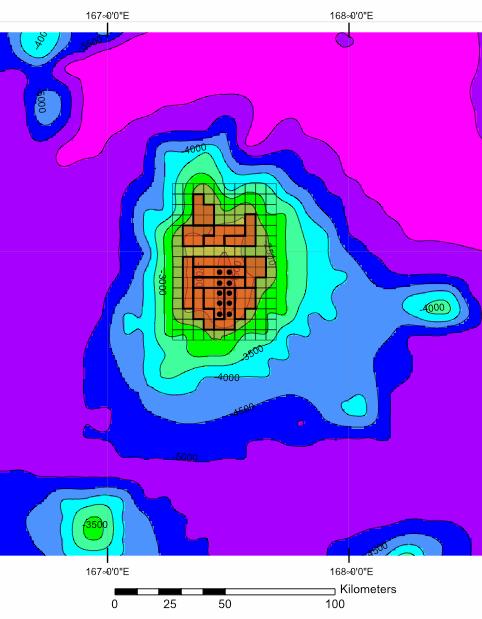
23 Seamount A Large composite seamount Total surface area: 9,309 km 2 Area above 2,500 m water depth: 2,939 km 2 This seamount can accommodate a single 20-year mine site
24 Seamount B

25 Seamount C
Assessment of the Japanese sardine (Sardinops melanostictus) stock in the northwestern Pacific for Japanese management system
 stock in the northwestern Pacific for Japanese management system") Assessment of the Japanese sardine (Sardinops melanostictus) stock in the northwestern Pacific for Japanese management system Hiroshi NISHIDA, Masayuki NOTO, Atsushi KAWABATA and Chikako WATANABE National
Assessment of the Japanese sardine (Sardinops melanostictus) stock in the northwestern Pacific for Japanese management system Hiroshi NISHIDA, Masayuki NOTO, Atsushi KAWABATA and Chikako WATANABE National
Scanning Sonar and ROV Operations. For Underwater SAR Imaging Applications
 Scanning Sonar and ROV Operations For Underwater SAR Imaging Applications This training module provides information specific to integrating scanning sonar onto an ROV platform and fundamentals in using
Utilizing Vessel Based Mobile LiDAR & Bathymetry Survey Techniques for Survey of Four Southern California Breakwaters
 Utilizing Vessel Based Mobile LiDAR & Bathymetry Survey Techniques for Survey of Four Southern California Breakwaters Western Dredging Association: Pacific Chapter September 2012 Insert: Pipe Location
Comments EXECUTIVE SUMMARY
 Comments 1. Under any Alternatives, MCDOT should provide better at-grade pedestrian crossing of Georgia Avenue and Forest Glen Road, including improved crosswalks with wider medians and adequate signal
Dec 6 3:08 PM. Density. Over the last two periods we discussed/observed the concept of density. What have we learned?
 Over the last two periods we discussed/observed the concept of density. What have we learned? is a ratio of mass to volume describes how much matter is packed into a space is a property of both solids
PROJECT Nº 96/005: SIZE SELECTIVITY AND RELATIVE FISHING POWER OF BALTIC COD GILL-NETS
 PROJECT Nº 96/005: SIZE SELECTIVITY AND RELATIVE FISHING POWER OF BALTIC COD GILL-NETS KEY WORDS Selectivity, fishing power, Baltic Sea, statistical model, fisheries management, cod (Gadus morhua). AUTHORS
DMU 008 Barry County Deer Management Unit
 DMU 8 Barry County Deer Management Unit Area Description The Barry County Deer Management Unit (DMU) 8 is in the Southwest Region and was once part of the Bellevue deer management unit 38. Bellevue DMU
Assessment Summary Report Gulf of Mexico Red Snapper SEDAR 7
 Assessment Summary Report Gulf of Mexico Red Snapper SEDAR 7 Stock Distribution: Red snapper are found throughout the Gulf of Mexico, the Caribbean Sea, and from the U.S. Atlantic Coast to northern South
Body Search and Recovery Using Sonar
 Body Search and Recovery Using Sonar Photos Mark W. Atherton Mark W. Atherton, Echoes and Images Image courtesy FBI Dive Team Images not for distribution. All photographs and drawings courtesy and Mark
RECAP The performance standard for fish biomass is an absolute standard that requires the Wheeler North Reef to support at least 28 US tons of reef
 1 RECAP The performance standard for fish biomass is an absolute standard that requires the Wheeler North Reef to support at least 28 US tons of reef dwelling fish. This was the estimated reduction in
Mesoscale modeling of the productive capacity of fish habitats in the littoral zone of reservoirs
 Mesoscale modeling of the productive capacity of fish habitats in the littoral zone of reservoirs Mesoscale modeling of the productive capacity of fish habitats in the littoral zone of reservoirs General
Overview. Beach Features. Coastal Regions. Other Beach Profile Features. CHAPTER 10 The Coast: Beaches and Shoreline Processes.
 Overview CHAPTER 10 The Coast: Beaches and Shoreline Processes Coastal regions constantly change. The beach is a dominant coastal feature. Wave activity continually modifies the beach and coastal areas.
Data Collection and Processing: Elwha Estuary Survey, February 2013
 Data Collection and Processing: Elwha Estuary Survey, February 2013 Ian Miller, WA Sea Grant Olympic Peninsula Field Office, 1502 E. Lauridsen Blvd #82, Port Angeles, WA 98362 immiller@u.washington.edu
SEISMIC SURVEY GREENLAND 2014 Underwater sound propagation for North East Greenland offshore seismic survey
 TGS February 2014 SEISMIC SURVEY GREENLAND 2014 Underwater sound propagation for North East Greenland offshore seismic survey Appendix: NEG14 modelling results Mark Mikaelsen PROJECT Seismic Survey Greenland
While the fishing standing stock at Wheeler North Reef has been consistently below the 28 ton requirement, data from last summer s survey showed that
 1 While the fishing standing stock at Wheeler North Reef has been consistently below the 28 ton requirement, data from last summer s survey showed that it increased by 88% in 2014. This raises the question
Norway lobster (Nephrops norvegicus) in Division 4.a, Functional Unit 32 (northern North Sea, Norway Deep)
 in Division 4.a, Functional Unit 32 (northern North Sea, Norway Deep)") ICES Advice on fishing opportunities, catch, and effort Greater North Sea Ecoregion Published 29 June 2018 Version 2: 14 November 2018 https://doi.org/10.17895/ices.pub.4439 Norway lobster (Nephrops norvegicus)
ICES Advice on fishing opportunities, catch, and effort Greater North Sea Ecoregion Published 29 June 2018 Version 2: 14 November 2018 https://doi.org/10.17895/ices.pub.4439 Norway lobster (Nephrops norvegicus)
3. A fluid is forced through a pipe of changing cross section as shown. In which section would the pressure of the fluid be a minimum?
 AP Physics Multiple Choice Practice Fluid Mechanics 1. A cork has weight mg and density 5% of water s density. A string is tied around the cork and attached to the bottom of a water-filled container. The
Experiment 1, Measurement and Density Chemistry 201, Wright College, Department of Physical Science and Engineering
 Name Date Experiment 1, Measurement and Density Chemistry 201, Wright College, Department of Physical Science and Engineering Making measurements in the laboratory involves equipment and instrumentation.
Juan de Fuca Recreational Chinook Fishery Proposal. Forum on Conservation & Harvest Planning for Fraser Salmon April 13, 2015
 Juan de Fuca Recreational Chinook Fishery Proposal Forum on Conservation & Harvest Planning for Fraser Salmon April 13, 2015 1 Outline Origin of proposal What is the rationale for the proposal? What is
R E V I S E D D A T E 0 4 /
 R E V I S E D D A T E 0 4 / 2 0 0 9 Guidelines Growing Oysters with the OysterGro System (OGS) Congratulations, you have just invested in one of the most efficient oyster growing system there is, the OysterGro.
NRCan Exploration & Deposit Appraisal Statistics for Northern Canada
 NRCan Exploration & Deposit Appraisal Statistics for Northern Canada NRCan Data as of February 2018 is sourced here: http://sead.nrcan.gc.ca/expl-expl/annual-eng.aspx Northern Canada Mineral Exploration
BOLAND DRIVE PATH PROJECT. Martin Le Jack Reilly Paul Rodriguez Allison Rotella Maria Wilson
 BOLAND DRIVE PATH PROJECT Martin Le Jack Reilly Paul Rodriguez Allison Rotella Maria Wilson INTRODUCTION TO PROJECT The purpose: to construct a multi-purpose path, which will connect two existing bike
Règlement pour la navigation pour la zone arctique. Alexey DUDAL Marine Division Bureau VERITAS
 Règlement pour la navigation pour la zone arctique Alexey DUDAL Marine Division Bureau VERITAS 1 Contents 1. Introduction 2. BV Rules and Guidelines for Ice-Going Vessels 3. Direct Calculation Tool 4.
The MEDUSA Deep Sea and FUSION AUVs:
 1 The MEDUSA Deep Sea and FUSION AUVs: When Research and business get together EMRA 2017, Girona, Spain 15 May 2017 Bruno Cardeira/IST Deep Ocean Exploration -Why the effort? Portugal Exclusive Economic
Taranaki Tsunami Inundation Analysis. Prepared for Taranaki Civil Defence Emergency Management Group. Final Version
 Taranaki Tsunami Inundation Analysis Prepared for Taranaki Civil Defence Emergency Management Group Final Version June 2012 AM 12/07 HBRC Plan Number 4362 Asset Management Group Technical Report Prepared
STRUCTURE AND FUNCTIONAL
 STRUCTURE AND FUNCTIONAL CHARACTERISTICS OF SEAMOUNTS ECOSYSTEMS TINA MOLODTSOVA P.P. SHIRSHOV INSTITUTE OF OCEANOLOGY RAS INTERNATIONAL WORKSHOP OF THE REMP FOR THE COBALT-RICH FERROMANGANESE CRUSTS IN
Advice June 2012
 2.4.1 Advice June 212 ECOREGION STOCK Iceland and East Greenland Beaked redfish (Sebastes mentella) in Subareas V, XII, and XIV and NAFO Subareas 1+2 (Deep pelagic stock > 5 m) Advice for 213 The advice
KY10-15 KAIYO / HYPER-DOLPHIN
 KY10-15 KAIYO / HYPER-DOLPHIN Kumano-Nada January 2011 Earthquake and Tsunami Research Project for Disaster Prevention JAMSTEC TABLE OF CONTENTS 1. INTRODUCTION 2. SCHEDULE 3. DIVE RESULTS 4. CONCLUSIONS
Digital Elevation Models
 Digital Elevation Models National Elevation Dataset 14-Oct-14 GEO327G/386G, UT Austin 1 Data Sets US DEM series 7.5, 30, 1 o for conterminous US 7.5, 15 for Alaska US National Elevation Data (NED) GTOPO30
Special request, Advice June New information regarding the impact of fisheries on other components of the ecosystem
 1.5.1.2 Special request, Advice June 2013 ECOREGION SUBJECT General advice New information regarding the impact of fisheries on other components of the ecosystem Advice summary ICES advises that the following
ENHANCED PARKWAY STUDY: PHASE 2 CONTINUOUS FLOW INTERSECTIONS. Final Report
 Preparedby: ENHANCED PARKWAY STUDY: PHASE 2 CONTINUOUS FLOW INTERSECTIONS Final Report Prepared for Maricopa County Department of Transportation Prepared by TABLE OF CONTENTS Page EXECUTIVE SUMMARY ES-1
Bottomfish Habitat and Restricted Fishing Area Analysis
 Bottomfish Habitat and Restricted Fishing Area Analysis Robert O Conner, NOAA National Marine Fisheries Service Chris Kelley, Hawaii Undersea Research Laboratory, University of Hawaii Study Area Essential
DMU 332 Huron, Sanilac and Tuscola Counties Deer Management Unit
 DMU 332 Huron, Sanilac and Tuscola Counties Deer Management Unit Area Description The Greenleaf Deer Management Unit (DMU 332) lies in the Southeast Region of the Southern Lower Peninsula (SLP) and covers
CORRELATION BETWEEN SONAR ECHOES AND SEA BOTTOM TOPOGRAPHY
 CORRELATION BETWEEN SONAR ECHOES AND SEA BOTTOM TOPOGRAPHY JON WEGGE Norwegian Defence Research Establishment (FFI), PO Box 115, NO-3191 Horten, Norway E-mail: jon.wegge@ffi.no False alarms resulting from
/ Advice May 2011
 1.5.1.3/1.5.4.1 Advice May 2011 ECOREGION SUBJECT General advice Update of cold-water coral and sponge maps and the information underpinning such maps on Vulnerable Marine Habitats (including Hatton and
The economic implications of changing regulations for deep sea fishing: UK case study
 The economic implications of changing regulations for deep sea fishing: UK case study Stephen Mangi, Andrew Kenny, Lisa Readdy, Paulette Posen, Ana Ribeiro-Santos, Francis Neat and Finlay Burns Mangi et
PILOT PROJECT: 2018 YOUTH TEAM AND DEVELOPMENT PROGRAM
 PILOT PROJECT: 2018 YOUTH TEAM AND DEVELOPMENT PROGRAM -OUTLINE AND SELECTION CRITERIA- (Version 1.0 March 2 nd, 2018) 1. SUMMARY: Karate Canada launched a pilot project in 2016, aimed at increased support
Using AUVs in Under-Ice Scientific Missions
 Using AUVs in Under-Ice Scientific Missions James Ferguson, International Submarine Engineering Ltd. Presented at Arctic Change 08 11 Decenber 2008- Quebec City, Canada 1/16 ISE s s Experience in Arctic
Exploration update: The majority of holes have intersected gold mineralizations
 Endomines AB Press Release Stockholm, 27th August 2013 Exploration update: The majority of holes have intersected gold mineralizations Endomines has carried out further exploration drilling at its properties
3. How many kilograms of air is in the room?
 1. Astronomers use density as a clue to the composition of distant objects. Judging by the orbits of its moons the mass of Saturn is found to be 5.68 10 26 kg. (a) Use its mean radius 58 230 km to determine
+)) Lower Churchill Project RIPRAP DESIGN FOR WIND-GENERATED WAVES SNC LAVALIN. SLI Document No HER
) Lower Churchill Project RIPRAP DESIGN FOR WIND-GENERATED WAVES SNC LAVALIN. SLI Document No HER") +)) SNC LAVALIN Lower Churchill Project RIPRAP DESIGN FOR SLI Document No. 505573-3001-4HER-0011-00 Nalcor Reference No. MFA-SN-CD-0000-CV-RP-0006-01 Rev. 81 Date: 07 -Dec-2012 Prepared by: Checked by:
+)) SNC LAVALIN Lower Churchill Project RIPRAP DESIGN FOR SLI Document No. 505573-3001-4HER-0011-00 Nalcor Reference No. MFA-SN-CD-0000-CV-RP-0006-01 Rev. 81 Date: 07 -Dec-2012 Prepared by: Checked by:
Agenda. REGIONAL REVIEW WELL RESULTS EAST FLANK PLAY FAIRWAY PROSPECTS and LEADS 3D SEISMIC SURVEY NINKY PROSPECT FUNDING ECONOMICS CONCLUSIONS
 PRESENTATION FEBRUARY 2011 1 Agenda 1. 2. 3. 4. 5. 6. 7. 8. 9. REGIONAL REVIEW WELL RESULTS EAST FLANK PLAY FAIRWAY PROSPECTS and LEADS 3D SEISMIC SURVEY NINKY PROSPECT FUNDING ECONOMICS CONCLUSIONS Subsurface
A Review of the Bed Roughness Variable in MIKE 21 FLOW MODEL FM, Hydrodynamic (HD) and Sediment Transport (ST) modules
 and Sediment Transport (ST) modules") A Review of the Bed Roughness Variable in MIKE 1 FLOW MODEL FM, Hydrodynamic (HD) and Sediment Transport (ST) modules by David Lambkin, University of Southampton, UK 1 Bed roughness is considered a primary
A Review of the Bed Roughness Variable in MIKE 1 FLOW MODEL FM, Hydrodynamic (HD) and Sediment Transport (ST) modules by David Lambkin, University of Southampton, UK 1 Bed roughness is considered a primary
Data Report : Russian River Basin Steelhead and Coho Salmon Monitoring Program Pilot Study
 Data Report 1999-1: Russian River Basin Steelhead and Coho Salmon Monitoring Program Pilot Study Sonoma County Water Agency 215 West College Avenue Santa Rosa, California 951 Prepared by David Cook Senior
Is lung capacity affected by smoking, sport, height or gender. Table of contents
 Sample project This Maths Studies project has been graded by a moderator. As you read through it, you will see comments from the moderator in boxes like this: At the end of the sample project is a summary
Absorption measurements for a carbon fiber couch top and its modelling in a treatment planning system
 Absorption measurements for a carbon fiber couch top and its modelling in a treatment planning system G. Kunz, F. Hasenbalg, P. Pemler 1 1 Klinik für Radio-Onkologie und Nuklearmedizin, Stadtspital Triemli
Dauphin Lake Fishery. Status of Walleye Stocks and Conservation Measures
 Dauphin Lake Fishery Status of Walleye Stocks and Conservation Measures Date: December, 21 Dauphin Lake Fishery Status of Walleye Stocks and Conservation Measures Background: Walleye stocks in Dauphin
Deep-sea volcano a hotspot for mysterious life 16 September 2016, by Caleb Jones
 Deep-sea volcano a hotspot for mysterious life 16 September 2016, by Caleb Jones A deep sea shark and several eels are attracted to bait placed at the summit of the Cook seamount, seen from the Pisces
Sea urchin density along a depth gradient at Rodney's Rock and Champagne Bay, Dominica
 Sea urchin density along a depth gradient at Rodney's Rock and Champagne Bay, Dominica Michele Felix Cassie Kalinec Julia Lemmon Carl Raetzsch A.J. Vale Andrew Woolley May 28 June 17, 2004 1 Abstract The
City of Rolling Hills Equestrian Facility Guidelines
 City of Rolling Hills Equestrian Facility Guidelines Drafted by the Stable Ad Hoc Committee STABLE GUIDELINES 1 2 [STABLE GUIDELINES] 2017 INTRODUCTION The Rolling Hills City Council noted a recent trend
Roundnose grenadier (Coryphaenoides rupestris) in Division 3.a (Skagerrak and Kattegat)
 in Division 3.a (Skagerrak and Kattegat)") Greater North Sea ecoregion Published 3 June 2016 9.3.28 Roundnose grenadier (Coryphaenoides rupestris) in Division 3.a (Skagerrak and Kattegat) ICES stock advice ICES advises that when the precautionary
Greater North Sea ecoregion Published 3 June 2016 9.3.28 Roundnose grenadier (Coryphaenoides rupestris) in Division 3.a (Skagerrak and Kattegat) ICES stock advice ICES advises that when the precautionary
A comparison of deltaic structure in forested and deforested watersheds using highresolution
 A comparison of deltaic structure in forested and deforested watersheds using highresolution bathymetric surveys Student: Willie Guerra Mentor: Kiram Lezzar Introduction Steeply sloping deltaic systems
Delegation of Australia
 SC-03-06.3.2 (10) 3 rd Meeting of the Southern Indian Ocean Fisheries Agreement (SIOFA) Scientific Committee 20-24 March 2017, Saint Denis, La Reunion Proposal for designation of the MIDDLE OF WHAT (MOW)
Coiled Tubing string Fatigue Management in High Pressure Milling Operation- Case Study
 Coiled Tubing string Fatigue Management in High Pressure Milling Operation- Case Study Abstract: Paper Presenter: Ebrahim Rabbani 1 e.rabbani@mehranservices.com Ebrahim Rabbani, Danial Davoodi 2, Fatemeh
Memorandum. Dr. Wilbert Odem, Dr. Paul Trotta, and Mr. Justin Ramsey. From: Timothy Mahon, Patrick Belsheim, and Ali Alrayyes.
 Memorandum To: Dr. Wilbert Odem, Dr. Paul Trotta, and Mr. Justin Ramsey From: Timothy Mahon, Patrick Belsheim, and Ali Alrayyes Date: 10/17/2013 Re: Routes Decision Matrix Decision Matrix Methodology The
Norway lobster (Nephrops norvegicus) in Division 4.a, Functional Unit 10 (northern North Sea, Noup)
 in Division 4.a, Functional Unit 10 (northern North Sea, Noup)") ICES Advice on fishing opportunities,, and effort Celtic Seas Ecoregion and Greater North Sea Ecoregions Published 30 June 2016 Version 2: 11 November 2016 6.3.25 Norway lobster (Nephrops norvegicus) in
ICES Advice on fishing opportunities,, and effort Celtic Seas Ecoregion and Greater North Sea Ecoregions Published 30 June 2016 Version 2: 11 November 2016 6.3.25 Norway lobster (Nephrops norvegicus) in
Rivers Inlet Salmon Initiative
 Rivers Inlet Salmon Initiative 5-YEAR BUSINESS PLAN C AS E F O R S U P P O R T M AR C H 2 0 1 5 Dedication Rick Hansen had been inspired to go to Rivers Inlet in July 2010 by his good friend, and fellow
Technical properties of purse seines targeting small pelagic species in the Adriatic Sea
 Technical properties of purse seines targeting small pelagic species in the Adriatic Sea Alessandro Lucchetti CNR-ISMAR, Ancona a.lucchetti@ismar.cnr.it Council Regulation 1967/2006 Article 13: Minimum
Marine Kit 4 Marine Kit 4 Sail Smooth, Sail Safe
 Marine Kit 4 Marine Kit 4 Sail Smooth, Sail Safe Includes Basic ship Terminologies and Investigation Check list Index 1. Ship Terminology 03 2. Motions of a Floating Body...09 3. Ship Stability.10 4. Free
RURAL HIGHWAY SHOULDERS THAT ACCOMMODATE BICYCLE AND PEDESTRIAN USE (TxDOT Project ) June 7, Presented by: Karen Dixon, Ph.D., P.E.
 June 7, Presented by: Karen Dixon, Ph.D., P.E.") RURAL HIGHWAY SHOULDERS THAT ACCOMMODATE BICYCLE AND PEDESTRIAN USE (TxDOT Project 0-6840) June 7, 2016 Presented by: Karen Dixon, Ph.D., P.E., TTI Team: Kay Fitzpatrick, Raul Avelar, & Subasish Das Project
RURAL HIGHWAY SHOULDERS THAT ACCOMMODATE BICYCLE AND PEDESTRIAN USE (TxDOT Project 0-6840) June 7, 2016 Presented by: Karen Dixon, Ph.D., P.E., TTI Team: Kay Fitzpatrick, Raul Avelar, & Subasish Das Project
HUGH THOMPSON FRA RDT RADIM BRUZEK ENSCO, INC. CHRIS MOALE
 Characterization of Fouled Ballast Track Demonstration with Multiple Technologies 2017 RIVIT Conference June 20-21, 2017 HUGH THOMPSON FRA RDT RADIM BRUZEK ENSCO, INC. CHRIS MOALE CSX TRANSPORTATION DAVE
ISC Pacific Bluefin tuna Stock Assessment 2016
 ISC Pacific Bluefin tuna Stock Assessment 2016 Completed in 2016-Feb. 29 th to 2016-Apr. 12 th at La Jolla, USA ISC Pacific Bluefin tuna Working Group 2016/5/10 San Diego Marriott La Jolla -IATTC SAC 07-
THE CHALLENGES OF A LARGE-AREA BATHYMETRIC SURVEY
 THE CHALLENGES OF A LARGE-AREA BATHYMETRIC SURVEY Agenda: - Introduction - Tender - Project Planning - Survey - Processing - Delivery - Conclusion 2 Introduction We know less of the oceans at our feet,
INTERNATIONAL SKATING UNION
 INTERNATIONAL SKATING UNION Communication No. 2128 SHORT TRACK SPEED SKATING PADDING MEASURES TO INCREASE SAFETY FOR SKATERS (This Communication will replace ISU Communication No. 1726, as of June 1, 2018)
Assessment of flooding on low-elevation reef-lined coasts
 Assessment of flooding on low-elevation reef-lined coasts Ap van Dongeren, Deltares, Delft, The Netherlands With Curt Storlazzi, USGS, Santa Cruz, USA Impact on coral reef-lined islands and coasts Coral
Rock Ramp Design Guidelines. David Mooney MS Chris Holmquist-Johnson MS Drew Baird Ph.D. P.E. Kent Collins P.E.
 Rock Ramp Design Guidelines David Mooney MS Chris Holmquist-Johnson MS Drew Baird Ph.D. P.E. Kent Collins P.E. Rock Ramp Design Guidelines OUTLINE Local and System Interactions with Rock Ramps Ramp Geometry
Our Council s Own: Oceanography Cadette/Senior/Ambassador Badge
 Our Council s Own: Oceanography Cadette/Senior/Ambassador Badge Oceanography: The science that deals with oceans, the delimitation of their extent and depth, the physics and chemistry of their water, marine
Potential applications of AUVs and Gliders in Offshore Windfarm Site Surveys
 Potential applications of AUVs and Gliders in Offshore Windfarm Site Surveys Dr James Hunt (National Oceanography Centre, Southampton) MREKE Internship in partnership with MARS at NOCS Introduction to
CONDITIONS OF USE OF THIS REPORT COPYRIGHT NAMIBIAN MARINE PHOSPHATE (PTY) LTD 2014 ALL RIGHTS RESERVED
 LTD 2014 ALL RIGHTS RESERVED") CONDITIONS OF USE OF THIS REPORT COPYRIGHT NAMIBIAN MARINE PHOSPHATE (PTY) LTD 2014 ALL RIGHTS RESERVED. All rights to the intellectual property and/or contents of this document remain vested in Namibian
CONDITIONS OF USE OF THIS REPORT COPYRIGHT NAMIBIAN MARINE PHOSPHATE (PTY) LTD 2014 ALL RIGHTS RESERVED. All rights to the intellectual property and/or contents of this document remain vested in Namibian
3D Inversion in GM-SYS 3D Modelling
 3D Inversion in GM-SYS 3D Modelling GM-SYS 3D provides a wide range of inversion options including inversion for both layer structure and physical properties for gravity and magnetic data. There is an
UNIT 2 FLUIDS PHYS:1200 LECTURE 12 FLUIDS (1)
") 1 UNIT 2 FLUIDS PHYS:1200 LECTURE 12 FLUIDS (1) Lecture 12 is the first lecture on the new topic of fluids. Thus far we have been discussing the physics of ideal solid objects that do not change their
1 UNIT 2 FLUIDS PHYS:1200 LECTURE 12 FLUIDS (1) Lecture 12 is the first lecture on the new topic of fluids. Thus far we have been discussing the physics of ideal solid objects that do not change their
Examples of Carter Corrected DBDB-V Applied to Acoustic Propagation Modeling
 Naval Research Laboratory Stennis Space Center, MS 39529-5004 NRL/MR/7182--08-9100 Examples of Carter Corrected DBDB-V Applied to Acoustic Propagation Modeling J. Paquin Fabre Acoustic Simulation, Measurements,
Guidelines for Providing Access to Public Transportation Stations APPENDIX C TRANSIT STATION ACCESS PLANNING TOOL INSTRUCTIONS
 APPENDIX C TRANSIT STATION ACCESS PLANNING TOOL INSTRUCTIONS Transit Station Access Planning Tool Instructions Page C-1 Revised Final Report September 2011 TRANSIT STATION ACCESS PLANNING TOOL INSTRUCTIONS
Panel Discussion on unmanned Hydrography
 Panel Discussion on unmanned Hydrography Overview Why bother General Types Autonomous Underwater Vehicle (AUV) Remotely Operated Vehicle (ROV) Unmanned Surface Vessels (USV) TerraSond s Experiences AUV
Geospatial Positioning Accuracy Standards Part 5: Standards for Nautical Charting Hydrographic Surveys - Public Review Draft
 Appendix B FGDC Hydrographic Accuracy Standard Geospatial Positioning Accuracy Standards Part 5: Standards for Nautical Charting Hydrographic Surveys - Public Review Draft Subcommittee on Marine and Coastal
Pelagic fishery for Sebastes mentella in the Irminger Sea
 3.2.6.d Pelagic fishery for Sebastes mentella in the Irminger Sea The stock structure of deep-sea redfish S. mentella in Sub-area XII, Division Va and Sub-area XIV and NAFO Div. 1F remains generally uncertain.
NEED FOR SUPPLEMENTAL BATHYMETRIC SURVEY DATA COLLECTION
 305 West Grand Avenue, Suite 300 Montvale, New Jersey 07645 Phone 201.930.9890 Fax 201.930.9805 www.anchorqea.com M EMORANDUM To: Caroline Kwan and Nica Klaber U.S. Environmental Protection Agency Region
Fluids. James H Dann, Ph.D. Say Thanks to the Authors Click (No sign in required)
") Fluids James H Dann, Ph.D. Say Thanks to the Authors Click http://www.ck12.org/saythanks (No sign in required) To access a customizable version of this book, as well as other interactive content, visit
Fluids James H Dann, Ph.D. Say Thanks to the Authors Click http://www.ck12.org/saythanks (No sign in required) To access a customizable version of this book, as well as other interactive content, visit
SEMAFO FOR. the Wona-Kona extending the scenarios and plunging. results in. to incoming. DDH No. Wona Kona g/t / 15.0 m
 PRESS RELEASE SEMAFO FOR IMMEDIATE RELEASE SEMAFO Further Expands the - Deposit at Mana Including Values of Up to 6.06 g/t Au Over 40 Meters and in a Parallel Zone, 4.09 g/t Au Over 17 Meters Montreal,
Culvert Design for Low and High Gradient Streams in the Midwest. Dale Higgins, Hydrologist Chequamegon-Nicolet National Forest
 Culvert Design for Low and High Gradient Streams in the Midwest Dale Higgins, Hydrologist Chequamegon-Nicolet National Forest Overview Culvert Design Considerations Hydraulic Terms Culvert Impacts Low
Data Set 7: Bioerosion by Parrotfish Background volume of bites The question:
 Data Set 7: Bioerosion by Parrotfish Background Bioerosion of coral reefs results from animals taking bites out of the calcium-carbonate skeleton of the reef. Parrotfishes are major bioerosion agents,
Design and Planning Considerations For a Seabed Survey
 Design and Planning Considerations For a Seabed Survey Vera Quinlan Hydrographer & Data Processor Seabed Survey Overview Survey Platform - What boat do I use? Survey Area / depth of water / objective &
from ocean to cloud HEAVY DUTY PLOUGH PERFORMANCE IN VERY SOFT COHESIVE SEDIMENTS
 HEAVY DUTY PLOUGH PERFORMANCE IN VERY SOFT COHESIVE SEDIMENTS Geoff Holland, Sarah Dzinbal (Alcatel-Lucent Submarine Networks) Email: geoff.holland@alcatel-lucent.com Alcatel-Lucent Submarine Networks
Best Practice Guidance for Assessing the Financial Performance of Fishing Gear: Industry-led gear trials
 Best Practice Guidance for Assessing the Financial Performance of Fishing Gear: Industry-led gear trials Prepared for The UK Fisheries Economic Network (UKFEN) by Seafish Introduction and Background Reducing
Paper Report for Possible Road Locations within Saint Edwards State Park
 Paper Report for Possible Road Locations within Saint Edwards State Park Jedediah Bryce Troy Lane Kim Littke Douglas Marconi Project #1 Submitted to: Professor Peter Schiess on April 4 th, 2009 ESRM 468
Year Avg. TAC Can Others Totals
 SKATE IN DIVISIONS 3L, 3N, 3O AND SUBDIVISION 3Ps Background There are 8 to 1 species of skate in the waters around Newfoundland. Of these, thorny skate (Raja radiata) is by far the most common, comprising
OPTIMUM ESCAPEMENT GOALS FOR CHINOOK SALMON IN THE TRANSBOUNDARY ALSEK RIVER
 Canadian Science Advisory Secretariat Science Advisory Report 2011/019 OPTIMUM ESCAPEMENT GOALS FOR CHINOOK SALMON IN THE TRANSBOUNDARY ALSEK RIVER Chinook salmon adult spawning phase. DFO website. Figure
Types of Forces. Pressure Buoyant Force Friction Normal Force
 Types of Forces Pressure Buoyant Force Friction Normal Force Pressure Ratio of Force Per Unit Area p = F A P = N/m 2 = 1 pascal (very small) P= lbs/in 2 = psi = pounds per square inch Example: Snow Shoes
Final Bull Trout Genetics Monitoring Plan for the Wallowa Falls Hydroelectric Project. (FERC No. P-308) June 2017
 June 2017") Final for the Wallowa Falls Hydroelectric Project (FERC No. P-308) June 2017 Prepared by: Jeremiah Doyle PacifiCorp 825 NE Multnomah Street Portland, OR 97232 June, 2017 Page 1 of 8 Table of Contents 1.0
Final for the Wallowa Falls Hydroelectric Project (FERC No. P-308) June 2017 Prepared by: Jeremiah Doyle PacifiCorp 825 NE Multnomah Street Portland, OR 97232 June, 2017 Page 1 of 8 Table of Contents 1.0
Drift Characteristics of Paroscientific pressure sensors
 Drift Characteristics of Paroscientific pressure sensors by Randolph Watts, Maureen Kennelly, Karen Tracey, and Kathleen Donohue (University of Rhode Island) PIES + current meter & CPIES arrays Paroscientific
Designing and Benchmarking Mine Roads for Safe and Efficient Haulage. Roger Thompson Alex Visser
 Designing and Benchmarking Mine Roads for Safe and Efficient Haulage Roger Thompson Alex Visser Departments of Mining and Civil & Bio-systems Engineering University of Pretoria, South Africa Aim of Presentation
SA2 + Div. 3K Redfish
 Fisheries and Oceans Pêches et Océans Canada Canada DFO Science Stock Status Report A2-15(21) entered the fishery in 1975 and averaged about 16,5 t from 1978-1986. The steady reduction in catches from
MINISTRY OF ENVIRONMENT ENVIRONMENTAL STEWARDSHIP DIVISION FISH AND WILDLIFE BRANCH. Horsefly River Angling Management Plan
 MINISTRY OF ENVIRONMENT ENVIRONMENTAL STEWARDSHIP DIVISION FISH AND WILDLIFE BRANCH Horsefly River Angling Management Plan January 30 th, 2006 Area/Fishery Description The Horsefly River watershed provides
Alternative Impedances for Shortest Path Network Analysis for Cycling
 Alternative Impedances for Shortest Path Network Analysis for Cycling Introduction Traditional impedances used in network analysis are travel time, travel distance and travel cost or some type of cost
San Lorenzo Valley Water District, Watershed Management Plan, Final Version Part I: Existing Conditions Report
 LIST OF FIGURES Figure 1-1. Map of the San Lorenzo River watershed Figure 2-1. The Santa Cruz Mountains Bioregion Figure 2-2. Protected areas within the San Lorenzo River watershed Figure 2-3. Primary
Step-by-Step Planning Guide
 B A C K Y A R D P L A N N I N G G U I D E Step-by-Step Planning Guide Whether you are considering purchasing a Michael Phelps Signature Swim Spa by Master Spas, or can t wait for yours to be delivered,
STOCK ASSESSMENT OF ALBACORE TUNA IN THE NORTH PACIFIC OCEAN IN 2011
 STOCK ASSESSMENT OF ALBACORE TUNA IN THE NORTH PACIFIC OCEAN IN 2011 Report of the ISC-Albacore Working Group Stock Assessment Workshop 3rd Science Advisory Committee Meeting Inter-American Tropical Tuna
Lecture 8 questions and answers The Biological Pump
 Lecture 8 questions and answers The Biological Pump (1) How long would it take a particle of about 2micron in size and a density of 1.5 g/cm 3 to get to the bottom of the sea (4000m)? How do particles
Hydrostatic Testing of In-Situ Pipelines & Spike Testing. Colin Silla, PE, PMP Southeast District Manager 6/27/18
 Hydrostatic Testing of In-Situ Pipelines & Spike Testing Colin Silla, PE, PMP Southeast District Manager 6/27/18 Hydrotest Design and Support: Statistics Piping and Test Heads Overall: GTS has designed
ACTIVITY 1: Buoyancy Problems. OBJECTIVE: Practice and Reinforce concepts related to Fluid Pressure, primarily Buoyancy
 LESSON PLAN: SNAP, CRACKLE, POP: Submarine Buoyancy, Compression, and Rotational Equilibrium DEVELOPED BY: Bill Sanford, Nansemond Suffolk Academy 2012 NAVAL HISTORICAL FOUNDATION TEACHER FELLOWSHIP ACTIVITY