INTRODUCTION TO STRUCTURE FISHING: IDENTIFICATION OF FISH LOCATIONS STRUCTURE FISHING
|
|
|
- Fay Lynch
- 5 years ago
- Views:
Transcription
1 INTRODUCTION TO STRUCTURE FISHING: IDENTIFICATION OF FISH LOCATIONS Featuring: - Migration Theory of fish. - Structure types: Point Bar Underwater Hump Channel Man Made - Understanding Breaks & Breaklines - How to establish trolling patterns. - Structure Fishing Definitions STRUCTURE FISHING Buck Perry is considered the grand-daddy of the concept of "Structure Fishing" having coined this term during the 1950's. He's the first fisherman to describe the use of underwater features to locate fish. These ideas incorporated below use his concepts to help identify these structural locations. The home of the fish is deep water, where the fish are dormant and very difficult to catch. Periodically, the fish becomes active, and move toward the shallows (food source) using underwater structure as a guide. These bottom features, which go all the way from the deep water to the shallow water, act as submerged highways for the fish during their movement. If we desire to catch fish consistently, we must be able to use these structural features as a guide to the location of the fish. During migration on structure, the fish will stop and hesitate at breaks and breaklines located on structure. We must identify these breaks and breaklines to pinpoint the exact location of the fish. We then present our lures on structure at the correct depth and speed to catch the fish. How far the fish migrate toward the shallows and how long they stay there is dependent on weather and water conditions. Home - About - Map Features - Catalog/Order Form - Structured Fishing Guide Phone:(303) Fax: (303)
2 Definitions Breaks - Objects found on the lake bottom.; Breakline - An imaginary line on the lake bottom created from a sudden increase or decrease in depth; An abrupt contrast in the underwater conditions ( i.e.: weedline, thermocline, shadeline, water color change, etc.) Channel - The submerged riverbed; A type of structure used by fish during migration. Contact Point - The point at which the fish make first contact with the structure when they start their migration. Deep Water - 30 ft. deep or deeper; the deepest water in the immediate area, usually the channel; the home of the fish. Drop Off - A breakline or structure where there is a sudden drop into the deepest water. Feeder Creek - A submerged gulch, creek, or wash that feeds into the main channel; Structure that fish use during their migration from deep water to shallow water. Flat - An area of the lake bottom that contains no structure. Food Source - An area of the lake that contains food for the fish; Usually an area having either an inlet with running water, a weed flat, rock reef, or a rip-rap, manmade structure. Hump - An underwater island; A structure in which the lake bottom rises up from the surrounding area. Migration - A movement of the fish from deep water to shallow water along certain underwater paths. Migration Route - The actual structure or breakline the fish use during their migration from deep water to the shallows. Point Bar - A type of underwater structure in which the shallow water protrudes out into the lake more than the surrounding area. Ridge - A type of structure where a long narrow hump exists along the sides of a channel or feeder creek; A levee. Rip-Rap - Large rocks placed by man along the sides of dams and roadways to prevent erosion. Rock Reef - A type of structure in which the bottom is covered by rock and rubble; A potential food source if found shallow. Saddle - A type of structure which is formed from two inside bends facing opposite directions. Sanctuary - An area in deep water where the fish are in a neutral or inactive state; The home of the fish. Shallow Water - Water with a depth of 10 feet or less. Shallows - An area containing shallow water. Steep Deep - An area void of structure, which contains very little shallow water due to steep shoreline, drop off conditions. Structure - A lake bottom feature that is distinctly different from the surrounding area. Thermocline - a horizontal plane of rapidly changing water temperature. Weedline (upper) - A line created from the contrast of weed growing to the waters' surface and weed which isn't growing to the surface. Weedline (lower) - A line created on the lake bottom where the weed stops growing due to depths too great for the weed to grow. Home - About - Map Features - Catalog/Order Form - Structured Fishing Guide Phone:(303) Fax: (303) info@fishnmap.com
3 FISHING STRATEGIES I. Fish Seek Food & Saftey For consistent fishing success, we must find these two conditions in or lake and present our lures or bait in these areas. Our fishing strategy consists of three key steps, next. II. Fishing Strategy - Three Steps to finding fish: 1. Find the Food Sources 2. Find the Deeper Water (Safety) & other safety features for the fish. 3. Find the structure connecting the food with the deeper water III. Types of Food Sources: 1. Running water inlet 2. Weeds Beds 3. Rock Reef 4. Large areas of shallow water where light can penetrate to the bottom of the lake. 5. Areas of submerged Timber & Brush in shallow water (less than 15' deep) IV. Deeper Water - Why Important? 1. Provides safety from surface predators. 2. Provides water temperature stability - no rapidly fluctuating temperatures. 3. Provides stable light conditions for the fish. V. Other safety features the fish use: 1. Weed Beds - Provide cover for the fish in shallow water. 2. Submerged Brush & Trees - Provide cover fot the fish in shallow water. 3. Rock Reefs - Provide cover for the fish in shallow water if spaces between rockes are large enough. VI. Identify the Structure connnecting the deeper water (safety) to the food source: 1. Poit Bar 2. Channels, Feeder Creeks, & Washes. 3. Underwater Hump (Submerged Island) 4. Rock Reef 5. Man-Made Structure (Submerged Roadbeds; Dams, etc.) Home - About - Map Features - Catalog/Order Form - Structured Fishing Guide Phone:(303) Fax: (303) info@fishnmap.com
 using underwater structure as a guide.")
4 MIGRATION THEORY OF FISH The home of the fish is deep water, where the fish are dormant and very difficult to catch. Periodically the fish become active and move toward the shallows (food source) using underwater structure as a guide. These bottom features, which go all the way from the deep water to the shallow water, act as submerged highways for the fish during their movement. Example of fish migration: Point Bar Structure- Top View - Fish: All Trout
 421-5994 Fax: (303) 420-0843 Email: info@fishnmap.")
5 Home - About - Map Features - Catalog/Order Form - Structured Fishing Guide Phone:(303) Fax: (303) info@fishnmap.com
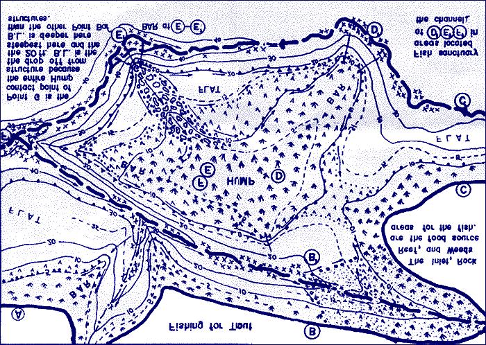
6 POINT BAR Requirements for a good Point Bar: 1. Point Bar goes all the way from the deep water to the shallow water. 2. Top of the Bar has large shallow water area with good food source. 3. Fish have immediate access to deep water. 4. Breakline into deep water (Drop Off) occurs at 15-30ft. deep. 5. Drop off plunges into submerged channel, which has Breaks. 6. Bar is Large with structural "fingers". 7. Drop off faces North. (shaded). Point Bars are important to recognize: 1. Fish use Point Bars as a guide to go from deep water to shallow water. 2. Point Bars increase the area of shallow water. 3. Good Point Bars make the shallow food accessable to deep water.
7 Home - About - Map Features - Catalog/Order Form - Structured Fishing Guide Phone:(303) Fax: (303) info@fishnmap.com
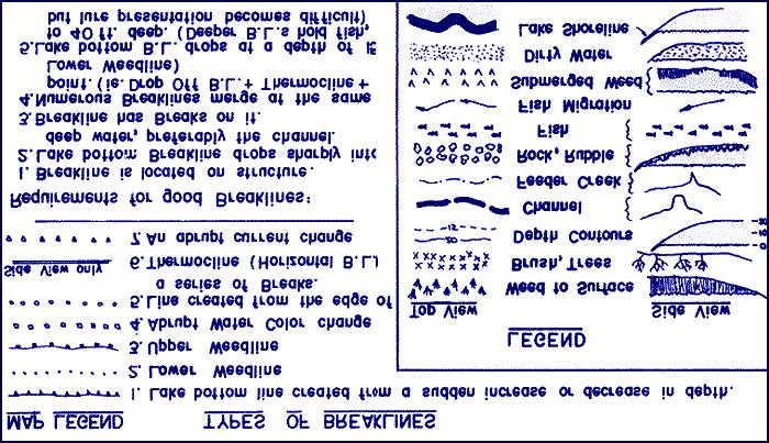
8 BREAKS & BREAKLINES


9 Why Breaks and Breaklines are important: Since the breaklines and structure are the actual migration routes of the fish, and Breaks offer "cover" and location identification for the fish, we must present the lure or bait directly over the Breaks and Breaklines on structure. If the Breakline is located 20ft. deep, we present the lure at 18 to 20ft. deep. When the fish are neutral or dormant, we present the lure or bait over their sanctuary in deep water. Trolling at the proper depth and speed is the fastest way to find the productive Breaks and Breaklines. Home - About - Map Features - Catalog/Order Form - Structured Fishing Guide Phone:(303) Fax: (303) info@fishnmap.com
10 POINT BAR Requirements for a good Point Bar: 1. Point Bar goes all the way from the deep water to the shallow water. 2. Top of the Bar has large shallow water area with good food source. 3. Fish have immediate access to deep water. 4. Breakline into deep water (Drop Off) occurs at 15-30ft. deep. 5. Drop off plunges into submerged channel, which has Breaks. 6. Bar is Large with structural "fingers". 7. Drop off faces North. (shaded). Point Bars are important to recognize: 1. Fish use Point Bars as a guide to go from deep water to shallow water. 2. Point Bars increase the area of shallow water. 3. Good Point Bars make the shallow food accessable to deep water.
11 Home - About - Map Features - Catalog/Order Form - Structured Fishing Guide Phone:(303) Fax: (303) info@fishnmap.com

12 CHANNEL Requirements fo good Channel structure: 1. Inlet has high water flow. (good food source) 2. Food Source adjacent to channel. 3. Channel has strong Breakline. 4. Feeder creeks enter channel. 5. Channel pulls in close to Point Bar, Hump, or Rock Reef. 6. There are breaks on the channel breakline. Channels are important to identify: 1. The channel is a natural highway for the fish. 2. Channel goes all the way from the deep water to the shallows. 3. The channel is the deepest water in the area and is often the home fo the fish. 4. The inlet is a food source, assuming water flow
 421-5994 Fax: (303) 420-0843 Email: info@fishnmap.")
13 Home - About - Map Features - Catalog/Order Form - Structured Fishing Guide Phone:(303) Fax: (303) info@fishnmap.com

14 HUMP Requirements for good structure: 1. The Hump has immediate access to deep water. 2. Top of Hump is flat & shallow (food). 3. Hump is adjacent to channel or creek. 4. Hump has strong 15-30ft. breakline into deep water. 5. Top of the Hump is large & has breaks. 6. Point Bars run all the way from the top of the Hump to deep water. Humps are important structure: 1. Humps can provide shallow food source. 2. Fish use Humps in defining their migration route. 3. Point Bars are often found with the Hump.
 421-5994 Fax: (303) 420-0843 Email: info@fishnmap.")
15 Home - About - Map Features - Catalog/Order Form - Structured Fishing Guide Phone:(303) Fax: (303) info@fishnmap.com

16 MAN MADE Types of Man-Made Structure: 1. Submerged Roadbed (R.R or auto). 2. Roadways crossing the lake. 3. Dam. 4. Bulldozed areas. Requirements fo good Man-Made structure: 1. Goes all the way from deep water to the shallows, which has a food source. 2. Strong Breakline on the sides of the submerged roadbed. 3. Crosses the main channel 4. Rip Rap covers the Man-Made structure.
 421-5994 Fax: (303) 420-0843 Email: info@fishnmap.")
17 Home - About - Map Features - Catalog/Order Form - Structured Fishing Guide Phone:(303) Fax: (303) info@fishnmap.com

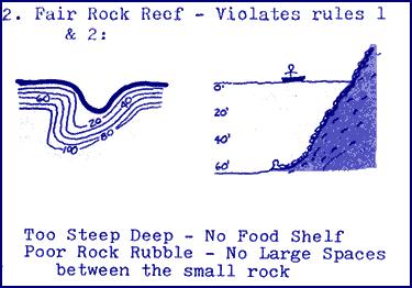
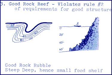
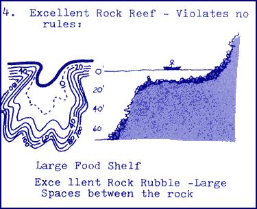
18 ROCK REEF Types of Rock Reefs- (from poor to excellent): 1. Solid Rock - Little Rubble. 2. Small rock of the same size-cobbler type. No spaces between rock. 3. Rock with undercuts & some rubble. 4. Rock Rubble - softball to Auto size. Excellent spaces between rocks. Requirements fo Good Rock Reef Structure. 1. Rock rubble is found in large spaces between the rocks - Plenty of room for fish & small organisms to hide. 2. Rock Reef covers a large area of shallow water (less than 15' deep.) 3. Rock Reef is adjacent to deep water. Rock Reefs are important to identify: 1. Rock Reefs, if found in shallow water, are potential food sources. 2. Fish use Rock Reefs for saftey to hide from other predators. 3. Rock Reefs can provide a natural migration route from deep water to the shallow food sources.
19 Phone:(303) Fax: (303)
HOW TO BEST USE YOUR ELECTRONICS: CHARTING, SONAR, AND IMAGING. By: Captain Tom Blackburn
 HOW TO BEST USE YOUR ELECTRONICS: CHARTING, SONAR, AND IMAGING By: Captain Tom Blackburn Topics I. INTRODUCTION II. CHARTING A TREMENDOUS FISH FINDING TOOL III. CHARTING - SIGNIFICANT CHARTING AND NAVIGATIONAL
THE LAKE FACTOR WATER TEMPERATURES & CURRENTS
 THE LAKE FACTOR WATER TEMPERATURES & CURRENTS A fisherman s ability to reliably control the speed & temperature at the lure is one of the key to catching great lakes fish. Those fisherman that are willing
Illinois Spoonpluggers
 Illinois Spoonpluggers Newsletter Dedicated to the teachings of E.L. Buck Perry The Father of Structure Fishing June Meeting Notes: 12 members attended the meeting. The first half of the meeting was spent
Water Habitat Model. Outcome: Materials: Teacher Instructions: : Identify the components of an animal habitat..
 Water Habitat Model Outcome: 4-1-03: Identify the components of an animal habitat.. Materials: Shoe boxes (1 per student) Art supplies: Glue and/or tape Paint and brushes for the background Plasticine/clay
Lake Powell Fish Report May 2, 2018 Lake Elevation: 3609 Water temperature: F By: Wayne Gustaveson or Wayneswords.
 Lake Powell Fish Report May 2, 2018 Lake Elevation: 3609 Water temperature: 59-64 F By: Wayne Gustaveson http://www.wayneswords.com or Wayneswords.net It s typically springtime weather with some warm days
Walleye in Georgia. For more information, visit 2
 Angler s Guide to Walleye Fishing in Georgia Georgia Department of Natural Resources, Wildlife Resources Division Fisheries Management Section February 2018 Walleye in Georgia Walleye is the most popular
Deep-water orbital waves
 What happens when waves approach shore? Deep-water orbital waves Fig. 9.16, p. 211 Wave motion is influenced by water depth and shape of the shoreline wave buildup zone surf zone beach Wave base deepwater
Canoe Route. Dogtooth Lake-Highwind Lake-Dryberry Lake- Lake of the Woods-Blindfold Lake
 1 Canoe Route Dogtooth Lake-Highwind Lake-Dryberry Lake- Lake of the Woods-Blindfold Lake This is an interesting and challenging route starting and ending at Rushing River Provincial Park. It passes over
Fly Fishing For Muskie Fellows Lake Springfield, Missouri
 Fly Fishing For Muskie Fellows Lake Springfield, Missouri Fellows Lake is an 820 acre water reservoir owned by City Utilities of Springfield. Fishing regulations are enforced by the Missouri Department
Reading Material. Inshore oceanography, Anikouchine and Sternberg The World Ocean, Prentice-Hall
 Reading Material Inshore oceanography, Anikouchine and Sternberg The World Ocean, Prentice-Hall BEACH PROCESSES AND COASTAL ENVIRONMENTS COASTAL FEATURES Cross section Map view Terminology for Coastal
Winter Drawdown Issues of Concern
 Winter Drawdown Issues of Concern Wetland Connectivity Amphibians Fisheries Winter Drawdown Wetland Connectivity Wetland complex near Osprey Creek is not responsive to lake level Wetland at upper end of
Claytor Lake View of the Claytor Lake dam from Claytor Lake State Park s boat ramp.
 Claytor Lake 2007 Imagine yourself on a waterbody that is more like a wide river than a lake. When you do, you will have a picture of Claytor Lake. Claytor Lake, a 4,475-acre reservoir, stretches northeastward
Outdoor Recreation Unit. Obj. 8, 9, 10
 Outdoor Recreation Unit Obj. 8, 9, 10 Fishing Equipment and Styles Fishing line Buy good quality line Select a proper test for expected fishing type Proper line for reel Line types Bait casting: braided
Chapter 10 Lecture Outline. The Restless Oceans
 Chapter 10 Lecture Outline The Restless Oceans Focus Question 10.1 How does the Coriolis effect influence ocean currents? The Ocean s Surface Circulation Ocean currents Masses of water that flow from one
Thanks to Burt Strom, Dick Pearce, and Ed Lombardo, Sr. for their help and information.
 The upper section of the Wood River that runs approximately two miles downstream from the bridge on State Route 165 contains a number of significant pools. Although the river is constantly changing through
If you have comments on this or suggestions for other terms that should be added to this glossary, please send an to
 Tide Gates Glossary There is very little information available anywhere related to tide gates and flap gates. This is a glossary of terms that are associated with, or useful when discussing, tide gates.
Coastal management has lagged behind the growth in population leading to problems with pollution
 Fifty percent of the population of the industrialized world lives within 100 km of a coast. Coastal management has lagged behind the growth in population leading to problems with pollution and natural
General Coastal Notes + Landforms! 1
 General Coastal Notes + Landforms! 1 Types of Coastlines: Type Description Primary Coast which is essentially in the same condition when sea level stabilized Coastline after the last ice age, younger.
Precision Sonar. Electronics Tip of the Week. Sonar Accessory website:
 Precision Sonar Electronics Tip of the Week Sonar Accessory website: http://precisionsonar.com/index.htm Use Electronic Topo Maps & Lowrance StructureScan To Locate High Percentage Areas In our sonar class
Largemouth Bass: Smallmouth Bass: Productive Lures: Crappie:
 April 10, 2015 Kentucky Lake: Water Level at Kentucky Dam - 356.68 Surface Temperature - 62 Lake Barkley: Water Level at Barkley Dam - 356.80 Surface Temperature - 62 Both lakes are about 2.5 feet below
Fish Community. Fish Habitat, Streams and Rivers
 Clear, Ston(e)y and White Lake Plan Fish Community The lakes support a cool/warm water fishery including muskellunge, walleye, largemouth and smallmouth bass, yellow perch, pumpkinseed, rockbass, blue
To Book a trip call or visit our website
 To Book a trip call 270-703-6133 or visit our website www.kicknbass.net October 6th, 2011 Lake Conditions Lake Levels As of this morning both lakes are approximately 3 feet below summer pool, give or take
Lake Mead Fishing Fun
 Lake Mead Fishing Fun Lake Mead Fishing Fun Location: : Lake Mead can only be described as really, really big. Located in Southern Nevada as part of the Colorado River System, it lies along the Arizona-Nevada
SEASONS SPRING SUMMER FALL WINTER DIRECT CORRELATION BETWEEN SEASONS AND WATER TEMPS
 LAKE EVERGREEN DEC. 27, 2014 CRAPPIE BASICS 2014 SEASONS SPRING SUMMER FALL WINTER DIRECT CORRELATION BETWEEN SEASONS AND WATER TEMPS 3 T S TO HELP YOU CATCH MORE CRAPPIE TEMPS TACTICS TACKLE ALIGNING
Understanding Types and Benefits of Fish Habitat
 Understanding Types and Benefits of Fish Habitat Leonard Dane Fisheries Biologist Deuchler Environmental, Inc. ILMA POD April 14, 2015 Wauconda, IL Importance of Fish Habitat What is fish habitat? those
To Book a trip call or visit our website
 To Book a trip call 270-703-6133 or visit our website www.kicknbass.net October 27th, 2011 Lake Conditions Lake Levels As of this morning both lakes are holding steady at winter pool give or take a few
Blue River Restoration Project William D. Linfield, P.E.
 Blue River Restoration Project William D. Linfield, P.E. 1 2 3 4 5 Blue River Restoration Project BUILDING BRIDGES BETWEEN COMMUNITIES IN COOPERATION WITH THE NATIONAL FOREST FOUNDATION Building Bridges
Illinois Lake Management Association Conference March 23, 2018 By Trent Thomas Illinois Department of Natural Resources Division of Fisheries
 Illinois Lake Management Association Conference March 23, 2018 By Trent Thomas Illinois Department of Natural Resources Division of Fisheries Sources of Habitat Impairment Sedimentation Channelization
Great Lakes Stream Crossing Inventory Instructions
 Great Lakes Stream Crossing Inventory Instructions This document is a guide to completing the Stream Crossing Data Sheet (2/28/11 version). Careful attention to this guidance will ensure consistent crossing
IF YOU ARE PLANNING ON VISITING OUR LAKES I HIGHLY RECOMMEND THE FOLLOWING BUSINESSES FOR ALL YOUR FISHING AND BOATING NEEDS:
 November 11, 2016 Kentucky Lake: Water Level at Kentucky Dam - 354.44 Surface Temperature - 65 Lake Barkley: Water Level at Barkley Dam - 354.45 Surface Temperature - 65 Both lakes are a few inches over
PRACTICE STANDARDS AND NR 328. Choosing a Technique and Getting a Permit
 PRACTICE STANDARDS AND NR 328 Choosing a Technique and Getting a Permit CHOOSING A TECHNIQUE Define cause of erosion Upland runoff? Impervious areas? Velocities? Wave energies? Boat or wind generated?
STREAM SURVEY File form No..
 scanned for KRIS THE RESOURCES AGENCY OF CALIFORNIA California Department of Fish and Game STREAM SURVEY File form No.. Date: September 4, 1969. NAME: North Fork Schooner Gulch Creek COUNTY: Mendocino.
Estuarine Shoreline Stabilization
 Estuarine Shoreline Stabilization Property Owner s Guide to Determining the Most Appropriate Stabilization Method Estuarine shorelines are dynamic features that experience continued erosion. Land is lost
Marginal Marine Environments
 Marginal Marine Environments Delta: discrete shoreline protuberances formed where rivers enter oceans, semi-enclosed seas, lakes or lagoons and supply sediment more rapidly than it can be redistributed
Regulations. Grabbling season May 1 July 15; only wooden structures allowed.
 Sardis Reservoir 218 REEL FACTS Keith Meals, Arthur Dunn, Stanley Turner Fisheries Biologists keithm@mdwfp.state.ms.us, ArthurD@mdwfp.state.ms.us, StanleyT@mdwfp.state.ms.us General Information: Sardis
JOCASSEE. Sam Jones doesn t know why trout relate to structural features that. Lake of the Month:
 Jocassee Lake of the Month: JOCASSEE Words & images by Jeff Samsel A mountain gem and home to a fine population of trout, Lake Jocassee serves up super April fishing. But in such a deep lake, where do
Five Counties Salmonid Conservation Program - Fish Passage Design Workshop. February 2013
 Program - Aquatic Organisms and Stream Crossings Ecological Connectivity A watershed is a network of channels that drain a common boundary. Channel characteristics formed by interaction of precipitation,
Call me or drop me an to fall trips with me now. The sooner you make a reservation, the more likely you are to get the date(s) you want.
 you want.") July 2, 2015 Kentucky Lake: Water Level at Kentucky Dam - 359.61 Surface Temperature - 83 Lake Barkley: Water Level at Barkley Dam - 359.70 Surface Temperature - 83 Both lakes are one half foot over summer
July 2, 2015 Kentucky Lake: Water Level at Kentucky Dam - 359.61 Surface Temperature - 83 Lake Barkley: Water Level at Barkley Dam - 359.70 Surface Temperature - 83 Both lakes are one half foot over summer
River Dynamics - Rafting FOCUS. Read 10 point text from rear of the room. Bottom
 Dynamics - Rafting FOCUS Read 10 point text from rear of the room. Bottom 1 This section focuses on rivers; how they flow and on some basic maneuvers which you can execute on the river. Dynamics Rafting:
Storm Damage Floating Culverts & Other Inlet Issues
 Storm Damage Floating Culverts & Other Inlet Issues Mark Bailey, PE - Hydraulic Manager, INDOT Dale Sedler, PE - Sr. Hydraulic Engineer, INDOT Road School 2016 What causes a culvert to float? 1. Accumulation
Temperature Mike Lazarus
 By Matt Straw Big water can be as intimidating to anglers as it is beautiful to sight- seers. Where to begin? So much water, so little time. A 54-inch musky is a pretty big needle, but the Great Lakes
Shoreline Erosion Control Failures and How To Avoid Them
 2008 Illinois Lake Management Association Shoreline Erosion Control Failures and How To Avoid Them by: Hank Sutton, President, Lake Rip Rap, Inc. www.lakeriprap.com - www.macoupinboats.com Setting the
Undertow - Zonation of Flow in Broken Wave Bores
 Nearshore Circulation Undertow and Rip Cells Undertow - Zonation of Flow in Broken Wave Bores In the wave breaking process, the landward transfer of water, associated with bore and surface roller decay
Tunica Cutoff 2018 REEL FACTS Keith Meals Fisheries Biologist
 Tunica Cutoff 218 REEL FACTS Keith Meals Fisheries Biologist keithm@mdwfp.state.ms.us General Information: Tunica Cutoff was created by the US Army Corps of Engineers (COE) in 1942 when a bend in the Mississippi
update ReleaseRig Jens concludes his two-part series on the benefits of smaller hooks when predator fishing release rig update part 2
 Jens concludes his two-part series on the benefits of smaller hooks when predator fishing ReleaseRig update Left: Traditionally mounted lures such as this Real Eel result in a much longer unhooking time,
Oceanic Zone. Open ocean past the continental shelf. Water can be very deep. Nutrients are scarce. Fewer organisms live in this zone
 Oceanic Zone Oceanic Zone Open ocean past the continental shelf Water can be very deep Nutrients are scarce Fewer organisms live in this zone Includes photic and aphotic zones Photic Zone Top 200m of
OECS Regional Engineering Workshop September 29 October 3, 2014
 B E A C H E S. M A R I N A S. D E S I G N. C O N S T R U C T I O N. OECS Regional Engineering Workshop September 29 October 3, 2014 Coastal Erosion and Sea Defense: Introduction to Coastal Dynamics David
Seagrasses of the Virgin Islands
 Seagrasses of the Virgin Islands Seagrasses are flowering plants that live underwater. These marine plants resemble the land species of grasses in that they have long blade-like leaves. Seagrasses grow
DMU 053 Mason County Deer Management Unit
 DMU 053 Mason County Deer Management Unit Area Description Mason County Deer Management Unit is in the Northern Lower Peninsula Region (NLP) on the Lake Michigan coast. Only 17% of the land base is public
Lecture Outlines PowerPoint. Chapter 15 Earth Science, 12e Tarbuck/Lutgens
 Lecture Outlines PowerPoint Chapter 15 Earth Science, 12e Tarbuck/Lutgens 2009 Pearson Prentice Hall This work is protected by United States copyright laws and is provided solely for the use of instructors
MAR 110 LECTURE #15 Wave Hazards
 1 MAR 110 LECTURE #15 Wave Hazards Rogue Wave Hazard Rogue waves are very large open ocean waves of sometimes can range in height from 60 ft (20m) to120 feet (40m) and thus a significant hazard to large
Tidal energy is produced by the surge of ocean waters during the rise and fall of tides. Tidal energy is a renewable source of energy.
 Encyclopedic Entry For Educator tidal energy For the complete encyclopedic entry with media resources, visit: http://www.connectenergyed.org/education/encyclopedia/tidal-energy/ Tidal energy is produced
Falls Lake Trail (A part of the NC Mountains-to-Sea Trail) East to West
 East to West") Falls Lake Trail (A part of the NC Mountains-to-Sea Trail) East to West Section 1 (Falls of the Neuse Rd to Raven Ridge Rd) 0.0 mi Parking area of the Tailrace Fishing Area, just below the dam, off Falls
Falls Lake Trail (A part of the NC Mountains-to-Sea Trail) East to West Section 1 (Falls of the Neuse Rd to Raven Ridge Rd) 0.0 mi Parking area of the Tailrace Fishing Area, just below the dam, off Falls
Regulations. Grabbling season May 1 July 15; only wooden structures allowed.
 Grenada Reservoir 218 REEL FACTS Keith Meals, Arthur Dunn, Stanley Turner Fisheries Biologists keithm@mdwfp.state.ms.us, ArthurD@mdwfp.state.ms.us, StanleyT@mdwfp.state.ms.us General Information: Grenada
Oceans and Coasts. Chapter 18
 Oceans and Coasts Chapter 18 Exploring the oceans The ocean floor Sediments thicken and the age of the seafloor increases from ridge to shore The continental shelf off the northeast United States Constituent
Volume and Shoreline Changes along Pinellas County Beaches during Tropical Storm Debby
 Volume and Shoreline Changes along Pinellas County Beaches during Tropical Storm Debby Ping Wang and Tiffany M. Roberts Coastal Research Laboratory University of South Florida July 24, 2012 Introduction
Notebooks or journals for drawing and taking notes
 Title: Have to Have a Habitat Grade Level: 5 th -8 th grade Topic: Trout Habitat Background: The following chart lists the ideal conditions for trout habitat. Dissolved Oxygen: > 7 mg/l ph: 5.5-7 Next
Oceans - Laboratory 12
 Oceans - Laboratory 12 (Name) How do ocean waves form? All waves are disturbances of a fluid medium through which energy is moved (Davis, 1997). Ocean waves travel on the interface between oceans and the
Regulations. Grabbling season May 1 July 15; only wooden structures allowed.
 Arkabutla Reservoir 219 REEL FACTS Keith Meals, Arthur Dunn, Stanley Turner Fisheries Biologists keithm@wfp.ms.gov, ArthurD@wfp.ms.gov, StanleyT@wfp.ms.gov General Information: Arkabutla Reservoir is one
CELEBRATING 30 YEARS
 1988-2017 CELEBRATING 30 YEARS 1st Place - Jason & Rich Shaw 1st Place 1 Lake news 1 Tournament Sponsor 2 Big Bass 2 Results (Places) 3 Event Pictures 4-7 Ledge Fishing 8-9 Complete Results 10 AOY Race
Draft report on one day visit to Brampton Bryan, R. Teme
 Dr Nick Giles & Associates, 50 Lake Road, Verwood, Dorset, BH31 6BX. Telephone 01202 824245 Fax 01202 828056 email nickgiles@cix.co.uk Consultants : Freshwater Fisheries, Conservation & Wetland Ecology
Illinois State Water Survey
 Illinois State Water Survey HYDROLOGY DIVISION SWS Contract Report 508 COMPARISON OF 1987 AND 1989 BED PROFILE SURVEYS OF THE LOWER CACHE RIVER by Richard Allgire Office of Sediment and Wetland Studies
* Making Rivers & Water Falls *
 www.krafttrains.com * Making Rivers & Water Falls * Several different methods are used to make this focal point of the layout. All the techniques are explained along with helpful hints and tips. Click
Water Resources Report RKLD Annual Meeting July 30, 2016
 Water Resources Report RKLD Annual Meeting 2016 July 30, 2016 Topics Hydrology Report Indianford Dam trash rack cleanout performance Experimental Project update Review of PAS project Twin floods- 1 to
Moon Lake 2019 REEL FACTS Nathan Aycock - Fisheries Biologist (601)
") Moon Lake 19 REEL FACTS Nathan Aycock - Fisheries Biologist NathanA@mdwfp.state.ms.us (61) 43- General Information: Moon Lake is a,3 acre oxbow lake of the Mississippi River. The primary inflow to the
Moon Lake 19 REEL FACTS Nathan Aycock - Fisheries Biologist NathanA@mdwfp.state.ms.us (61) 43- General Information: Moon Lake is a,3 acre oxbow lake of the Mississippi River. The primary inflow to the
Walleye are caught on bottom bouncers with worms, on plastic baits retrieved close to the. May 30, Bluegill Prizes Awarded this Week.
 Lake Powell Fish Report May 30, 2018 Lake Elevation: 3611 Water temperature: 67-74 F By: Wayne Gustaveson http://www.wayneswords.com or Wayneswords.net Lake Powell continues to rise with inflow doubling
SKIATOOK LAKE MANAGEMENT PLAN
 SKIATOOK LAKE MANAGEMENT PLAN Background Skiatook Lake impounds Hominy Creek, 5 miles west of Skiatook in Osage County, Oklahoma (Figure 1). Skiatook Lake covers 10,540 surface acres and was constructed
Shore - place where ocean meets land Coast - refers to the larger zone affected by the processes that occur at this boundary.
 Waves, Beaches, and Coasts Shore - place where ocean meets land Coast - refers to the larger zone affected by the processes that occur at this boundary. Waves: energy moving through water The height of
DEAD-ENDCHANNELFLUSHINGINHARBORS
 DEAD-ENDCHANNELFLUSHNGNHARBORS PURPOSE: The purpose of this technical note is to present some design con- siderations which benefit dead-end channel flushing. Some of these factors can also be used to
Highland Region MAP. No. 11 St. Marys River No. 12 West River No. 13 Wallace River No. 14 Toney River No. 15 Northumberland Strait
 Highland Region MAP No. 11 St. Marys River No. 12 West River No. 13 Wallace River No. 14 Toney River No. 15 Northumberland Strait 14 Route: No. 11 St. Marys River Rating: Intermediate Advanced Length:
Oceans in Motion: Waves and Tides
 Oceans in Motion: Waves and Tides Waves Waves are among the most familiar features in the ocean. All waves work similarly, so although we are talking about ocean waves here, the same information would
Life at its Peak of Exuberance: Coral Reefs and Tropical Rainforests
 Life at its Peak of Exuberance: Coral Reefs and Tropical Rainforests Note: These links do not work. Use the links within the outline to access the images in the popup windows. This text is the same as
Lake Seminole. and Waters Bordering Georgia and Alabama
 Lake Seminole and Waters Bordering Georgia and Alabama LAKE SEMINOLE Site Description Lake Seminole is a 37,500-acre reservoir located at the juncture of the Florida, Georgia, and Alabama state lines.
The Agility Association of Canada
 APPENDIX F - OBSTACLE CONSTRUCTION STANDARDS, 2018 JUMP HEIGHTS F 2 Obstacle Specifications F 2.5 Jumps: General Construction Notes Notes: Jump height is measured from the ground to the top of the pole
Brook Trout Life Cycle and Habitat
 Brook Trout Life Cycle and Habitat Directions: 1. As you watch this slide show, watch for vocabulary terms we learned today. The first time they appear, you will see them in RED! (not redd!) 2. At the
FISH MORPHOLOGY. The Education Program at the New Jersey Marine Sciences Consortium. njmsc.org
 FISH MORPHOLOGY OVERVIEW OBJECTIVE Students study the parts of a fish to develop the understanding that the shape, form and structure of a fish s parts influence its lifestyle and behavior. Following completion
EPA R6 Dive Team Operations Report. San Jacinto Waste Pits Channelview, TX December 9-10, 2015
 EPA R6 Dive Team Operations Report San Jacinto Waste Pits Channelview, TX December 9-10, 2015 BACKGROUND The San Jacinto River Waste Pit Site history has been documented in several documents prepared for,
Regulations. Grabbling season May 1 July 15; only wooden structures allowed.
 Sardis Reservoir 19 REEL FACTS Keith Meals, Arthur Dunn, Stanley Turner Fisheries Biologists keithm@wfp.ms.gov, ArthurD@wfp.ms.gov, StanleyT@wfp.ms.gov General Information: Sardis Reservoir is one of four
Delaware Chapter Surfrider Foundation - Indian River Inlet Monitoring
 Delaware Chapter Surfrider Foundation - Indian River Inlet Monitoring In 2012, the Delaware Surfrider Foundation Chapter formed the Surf Quality and Access Committee to focus on issues such as surf spot
OCEANOGRAPHY STUDY GUIDE
 OCEANOGRAPHY STUDY GUIDE Chapter 2 Section 1 1. Most abundant salt in ocean. Sodium chloride; NaCl 2. Amount of Earth covered by Water 71% 3. Four oceans: What are they? Atlantic, Pacific, Arctic, Indian
APPENDIX B HYDRAULIC DESIGN DATA FOR CULVERTS
 TM 5-820-4/AFM 88-5, Chap 4 APPENDIX B HYDRAULIC DESIGN DATA FOR CULVERTS B-1. General. a. This appendix presents diagrams, charts, coefficients and related information useful in design of culverts. The
Undertow - Zonation of Flow in Broken Wave Bores
 Lecture 22 Nearshore Circulation Undertow - Zonation of Flow in Broken Wave Bores In the wave breaking process, the landward transfer of water, associated with bore and surface roller decay within the
Estimated on-the-ground start and end dates: 1 June October 2018
 A. Applicant Information Name of Organization: U.S. Army Corps of Engineers, Carlyle Lake 801 Lake Road, Carlyle, IL 62231 Contact Information: Robert Wilkins, Operations Manager, (618) 594-2484, Robert.Wilkins@usace.army.mil
3.9 FROM ISLANDS TO ATOLLS
 3.9 1 3.9 FROM ISLANDS TO ATOLLS OBJECTIVES The students Listen to a description of the formation of volcanic islands, fringing reefs, barrier reefs, and atolls. Observe and participate in a simulation
Creation of Fish and Wildlife Habitat on the Closed Salmon Harbour Mine in Minto, NB
 Creation of Fish and Wildlife Habitat on the Closed Salmon Harbour Mine in Minto, NB M. Coleman 1, R. Rutherford 2, RA Currie 3 1 NB Power 2 Thaumas Environmental Consultants Ltd 3 RA Currie Ltd. Location
Your web browser (Safari 7) is out of date. For more security, comfort and the best experience on this site: Update your browser Ignore
 is out of date. For more security, comfort and the best experience on this site: Update your browser Ignore") Your web browser (Safari 7) is out of date. For more security, comfort and the best experience on this site: Update your browser Ignore TIDAL ENERGY For the complete encyclopedic entry with media resources,
Your web browser (Safari 7) is out of date. For more security, comfort and the best experience on this site: Update your browser Ignore TIDAL ENERGY For the complete encyclopedic entry with media resources,
Advanced Hydraulics Prof. Dr. Suresh A. Kartha Department of Civil Engineering Indian Institute of Technology, Guwahati
 Advanced Hydraulics Prof. Dr. Suresh A. Kartha Department of Civil Engineering Indian Institute of Technology, Guwahati Module - 4 Hydraulic Jumps Lecture - 1 Rapidly Varied Flow- Introduction Welcome
GOZO COLLEGE. Half Yearly Examinations for Secondary Schools FORM 4 PHYSICS TIME: 1h 30min
 GOZO COLLEGE Track 3 Half Yearly Examinations for Secondary Schools 2016 FORM 4 PHYSICS TIME: 1h 30min Name: Class: Answer all questions. All working must be shown. The use of a calculator is allowed.
FC-CIV HIDRCANA: Channel Hydraulics Flow Mechanics Review Fluid Statics
 FC-CIV HIDRCANA: Channel Hydraulics Flow Mechanics Review Fluid Statics Civil Engineering Program, San Ignacio de Loyola University Objective Calculate the forces exerted by a fluid at rest on plane or
Homework #14, due Wednesday, Nov. 28 before class. Quiz #14, Wednesday November 28 at the beginning of class
 ANNOUNCEMENTS Homework #14, due Wednesday, Nov. 28 before class Conceptual questions: Chapter 14, #8 and #16 Problems: Chapter 14, #58, #66 Study Chapter 14 by Wednesday Quiz #14, Wednesday November 28
Launch A: Experimental Lakes Road The launch site is about 4 km from highway #17. There is a sign on the highway indicating the experimental lakes
 Launch A: Experimental Lakes Road The launch site is about 4 km from highway #17. There is a sign on the highway indicating the experimental lakes road. You have to cross railway tracks on the way to the
A carp will know the lakebed like the back of its fin and we can only build a picture of what it s really like unless we drain the lake!
 THAT S THE SPOT! It s way more important than having the right look it s having a bait where they just have to pick it up Words:. Photography: and friends. SAME SPOTS Hi there, I say to the angler who
To Book a trip call or visit our website
 To Book a trip call 270-703-6133 or visit our website www.kicknbass.net May 10, 2013 Lake Conditions Lake Levels Note: Both Dams will be Spilling Until Further Notice. As of this morning both lakes are
Plan B Dam Breach Assessment
 Plan B Dam Breach Assessment Introduction In support of the Local Sponsor permit applications to the states of Minnesota and North Dakota, a dam breach analysis for the Plan B alignment of the Fargo-Moorhead
OIMB GK12 CURRICULUM. LIGHT IN THE DEEP SEA Adapted from NOAA s All That Glitters
 5th Grade 60 minutes LIGHT IN THE DEEP SEA Adapted from NOAA s All That Glitters Oregon Science Content Standards: 5.2 Interaction and Change: Force, energy, matter, and organisms interact within living
Bay Fishing
 www.halfhitch.com www.legendarymarine.com 05-16-2014 Bay Fishing If you have not given bay fishing a chance, you are definitely missing out on a year-round fishery. Here along the Florida Panhandle we
Eardley Canyon, Straight Wash San Rafael Swell, Central Swell
 Eardley Canyon, Straight Wash San Rafael Swell, Central Swell Rating: Best Season: Time: Access: Permit: Equipment: Map: Cold Protection: Drinking Water: Flash Flood Risk: Skills Required: Technical Note:
Spring Lake 2017 REEL FACTS Keith Meals Fisheries Biologist
 Spring Lake 217 REEL FACTS Keith Meals Fisheries Biologist keithm@mdwfp.state.ms.us General Information: Spring Lake is a clear, shallow 6 acre spring-fed impoundment in Wall Doxey State Park. Nearly half
4/20/17. #30 - Coastlines - General Principles Coastlines - Overview
 Writing Assignment Due one week from today by 11:59 pm See main class web pages for detailed instructions Essays will be submitted in Illinois Compass (instructions later) Pick one: Earthquakes, tsunamis,
Figure 1. Schematic illustration of the major environments on Mustang Island.
 STOP #1: PACKERY CHANNEL BEACH TO BAY We will start this field guide near the north jetty of Packery Channel and hike across the island to Corpus Christi Bay (fig. 1). The island emerges from the Gulf