ALARO physics developments
|
|
|
- Sheila Turner
- 5 years ago
- Views:
Transcription

1 Regional Cooperation for Limited Area Modeling in Central Europe ALARO physics developments Neva Pristov contributions from R. Brožkova, J. Mašek, L. Gerard, Ivan Baštak Duran, C. Wastl, C. Wittmann, M. Dian, A. Mary, Y. Seity, L. Rontu EWGLAM and SRNWP meetings
2 Talk outline ALARO status overview first ALARO-1 version available novelties in radiation scheme example with solar eclipse shallow convection inside TOUCANS Parameterization of orographic effect on radiation at surface Outlook Enhancement of deep convection
3 ALARO status In the operational use in ALADIN countries ALARO-0: at, be, hr, hu, ro, sk, si, tr ALARO-1vA: cz, po model resolution between 8 km 4 km, 2km National posters In EPS systems ALADIN-LAEF, GLAMEPS, EPS at HMS HarmonEPS convection-permitting ensemble system In climatological simulations be, cz, se
4 First version of ALARO-1 Assembling Turbulence and shallow convection scheme TOUCANS Prognostic TKE and TTE Parameterization of moist third order moments Turbulent diffusion of cloud condensates Mixing length (same as in ptke) Shallow convection (same as in alaro-0) Radiation ACRANEB2 Significantly improved Microphysics Improved rain drop size distribution More sophisticated vertical geometry of cloud and precipitation Retuning (significant effort needed)


5 First version of ALARO-1 Is a multi-scale, able to run at various horizontal resolution, across the gray zone of convection, down to 1 km Operational CHMI and IMGW Validation ongoing in several services winter T RMSE diff, red - improvement winter T2m STDEV red alaro1
6 ACRANEB2 radiation scheme
7 ACRANEB2 novelties concept of effective cloud optical depth was revisited better justified vertical dependency parameterization of SW gas-cloud overlap is included SW absorption is reduced due to competition between water vapour and clouds description of SW part (Mašek, QJRMS, 2015)
8 ACRANEB2 Accuracy of the new SW radiation Few % for fluxes at surface and at top of atmosphere summer day, clear sky summer day, cloudy error of direct flux at surface, error of downward diffuse flux at surface error of upward diffuse flux at the top of atmosphere
9 ACRANEB2 Accuracy of the new SW radiation SW heating rates for summer convection day in Prague (29 June 2009) morning (low sun) noon (high sun) narrowband reference ACRANEB2 (broadband) ACRANEB2 no gas-cloud overlap ACRANEB2 no cloud optical saturation
10 ACRANEB2 Accuracy of the new SW radiation Accuracy of the new SW radiation SW heating rates for summer convection day in Prague (29 June 2009) Cloud optical saturation is crucial morning (low sun) noon (high sun) Gas-cloud overlap gives minor improvement Typical error of ACRANEB2 against narrowband reference is 0.1K/day for clear sky and below 1K/day for cloudy narrowband reference ACRANEB2 (broadband) ACRANEB2 no gas-cloud overlap ACRANEB2 no cloud optical saturation
11 ACRANEB2 for the operational use Validation outcomes diurnal cycle of convective precipitation is significantly improved this is possible because cloud optical properties are updated at every time step still present known weakness underestimated low inversion cloudiness in the cold season strongly influences radiative fluxes
12 Shallow convection Developments: shallow convection within turbulence scheme TOUCANS a simple mass flux model with simplified entrainment profiles validation is ongoing shallow convection cloudiness for radiation
13 Shallow convection Ratio between dry and saturated case of shallow convection at and 18 UTC summer day winter day 12 UTC 15 UTC 12 UTC 9 UTC 9 UTC 6 UTC


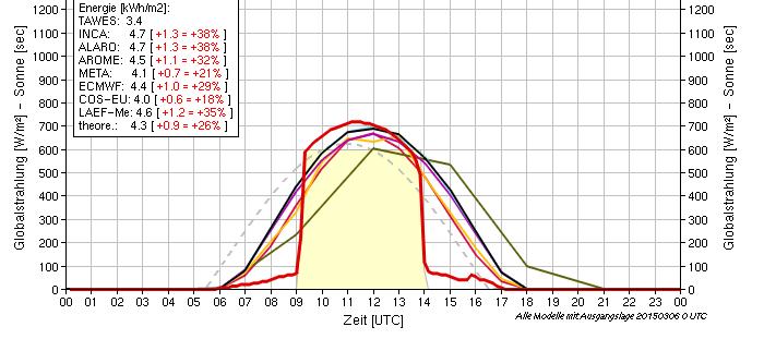
14 Solar eclipse on 20 March 2015 eclipse was implemented in operational version of ALADIN/CHMI incoming solar radiation at the top of atmosphere was modulated according to actually covered part of solar disc


15 Solar eclipse on 20 March 2015 Czech area: 1h sum of surface global radiation was reduced by ~ 50%, daily sum by ~10%, impact on T2m exceeded -1K
16 Solar eclipse on 20 March days ALADIN forecast and observation for Prague downward surface shortwave flux cloud cover control run without eclipse operational run with eclipse observation
17 Parameterization of orographic effects on surface radiation
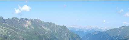
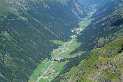

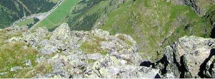
18 Orographic effects parametrization for radiation Motivation Pytztal, Tyrol, Austria

19 Orographic effects parametrization for radiation short wave radiation long wave radiation Taking into account SW direct: shadowing of direct solar radiation by orography SW direct: angle/direction of slope with respect to sun SW diffusive: reduced fraction of sky visible LW: reduced fraction of sky visible Basic orographic factors: sky view factor, slope aspect, shadow fraction
20 Orographic effects parametrization for radiation Implemented inside SURFEX Orographic parameters from SRTM (90m) data Slope, shadow, sky view factors are computed Radiation fluxes at surface are modified Tests in AROME 2.5 and 1 km show strong benefit Alpine valleys are colder, mountain slopes warmer Differences between sunny and shady slopes e-suite in Météo-France and ZAMG
21 Orographic effects parametrization for radiation DSH shadow effect DSV sky view effect Short wave global radiation DSH - a significant effect in the morning and evening hours Effect is generally higher on the 1km grid


22 Orographic effects parametrization for radiation Differences for 2m temperature between AROME using orographic radiation parameterization and AROME reference for sunny day over Central Europe, , at 12UTC on zoom around Innsbruck a very realistic slope effect: warmer slopes (directed to sun), colder slopes in the shadow
23 Deep convection A new deep convection scheme (Gerard, Mon. Wea. Rev. October 2015) CSD (Complementary Subgrid Draft) in testing showed an improved behaviour at high resolution the execution time of the model with CSD is around 10% longer than with 3MT uses the signal of shallow transport from the turbulence scheme allows a gradual fading out of the parameterized signal at high resolution


")
24 Summer convection 2 July 2009 ( 3-hour precipitation at 18 UTC) Deep convection
")

25 Summer convection 2 July 2009 ( 3-hour precipitation at 18 UTC) Deep convection Sub-grid precipitation are reduced Lack of meso-scale structure
26 Deep convection Expectation improvement of the diurnal cycle the multi-scale behavior the potential to produce realistic forecasts at fine resolution How to keep meso-scale organization below 2 km? sometimes can be too weak when the deep convection is represented explicitly with some re-tuning of diffusion with the use of cellular automata
27 Outlook Enhancement of the 3MT downdraft parameterization towards unsaturated downdraft option Adding aspects of Complementary Sub-grid Drafts to new radiation, turbulence and microphysics Further enhancements of the shallow convection and mixing length scale parameterization in TOUCANS Steps towards the unification of cloud cover representation Linking with the SURFEX scheme
François Bouyssel CNRM-GAME. ECMWF/WCRP/WWRP workshop on drag processes and their links to largescale circulation, September 2016, Reading
 Parametrizations of sub-grid orography effects in global and regional models at Météo-France. Sensitivity studies to parametrizations and horizontal resolution. François Bouyssel CNRM-GAME ECMWF/WCRP/WWRP
Conditions for Offshore Wind Energy Use
 Carl von Ossietzky Universität Oldenburg Institute of Physics Energy Meteorology Group Detlev Heinemann Conditions for Offshore Wind Energy Use Detlev Heinemann ForWind Carl von Ossietzky Universität Oldenburg
Impacts of diffusion in stable boundary layers and orographic drag
 Impacts of diffusion in stable boundary layers and orographic drag Irina Sandu Thanks: Anton Beljaars, Ted Shepherd, Ayrton Zadra, Felix Pithan, Alessio Bozzo, Peter Bechtold 1 Outline Context: drag and
Experience with the representation of stable conditions in the ECMWF model
 Experience with the representation of stable conditions in the ECMWF model Irina Sandu Anton Beljaars, Gianpaolo Balsamo, Peter Bechtold, Mark Rodwell 1. Stable conditions: current issues 2. Land-atmosphere
Report from stay in Ljubljana : 5 May - 31 May 2013
 Report from stay in Ljubljana : 5 May - 31 May 2013 executed by: Ivan Bašták Ďurán supported by: Benedikt Strajnar, Jure Cedilnik, Neva Pristov and Jure Jerman 9.7.2013 Contents 1 TOUCANS implementation
The impacts of explicitly simulated gravity waves on large-scale circulation in the
 The impacts of explicitly simulated gravity waves on large-scale circulation in the Southern Hemisphere. Linda Mudoni Department of Geological and Atmospheric Sciences October 2003 Introduction In the
1 INTRODUCTION. Figure 2: Synoptical situation at the beginning of the simulation: 5th January 1999 at 12UTC.
 2.2 NOCTURNAL CIRCULATIONS UNDER WEAK PRESSURE GRADIENTS IN THE ISLAND OF MALLORCA J. Cuxart and M.A. Jiménez Universitat de les Illes Balears, Spain 1 INTRODUCTION To study the local nocturnal circulations
A R e R v e iew e w on o n th t e h e Us U e s s e s of o Clou o d u - (S ( y S s y t s e t m e )-Re R sol o ving n Mod o e d ls Jeff Duda
-Re R sol o ving n Mod o e d ls Jeff Duda") A Review on the Uses of Cloud- (System)-Resolving Models Jeff Duda What is a Cloud-Resolving-Model (CRM)? General definition: A model with the following properties Resolution high enough to be able to
A Review on the Uses of Cloud- (System)-Resolving Models Jeff Duda What is a Cloud-Resolving-Model (CRM)? General definition: A model with the following properties Resolution high enough to be able to
Development of model physics at ECMWF
 Development of model physics at Anton Beljaars () Example of physics related output Physics changes after ERA-40 (CY23R4) Evolution of spin-up in operations after CY23R4 Examples of changes with respect
Parameterizations (fluxes, convection)
") Parameterizations (fluxes, convection) Heinke Schlünzen Meteorological Institute, University of Hamburg New resolutions - new challenges What is the current status? Surface fluxes Convection Towards improving
Parameterizations (fluxes, convection) Heinke Schlünzen Meteorological Institute, University of Hamburg New resolutions - new challenges What is the current status? Surface fluxes Convection Towards improving
Chapter 4: Moisture and Atmospheric Stability The hydrologic cycle
 Chapter 4: Moisture and Atmospheric Stability The hydrologic cycle from: USGS http://water.usgs.gov/edu/watercycle.html Evaporation: enough water to cover the entire surface of Earth to 1 meter cycles
Mountain Forced Flows
 Mountain Forced Flows Jeremy A. Gibbs University of Oklahoma gibbz@ou.edu February 3, 2015 1 / 45 Overview Orographic Precipitation Common Ingredients of Heavy Orographic Precipitation Formation and Enhancement
The total precipitation (P) is determined by the average rainfall rate (R) and the duration (D),
 is determined by the average rainfall rate (R) and the duration (D),") Orographic precipitation Common ingredients of heavy orographic precipitation The total precipitation (P) is determined by the average rainfall rate (R) and the duration (D), P = RD. (1) The rainfall rate
Orographic precipitation Common ingredients of heavy orographic precipitation The total precipitation (P) is determined by the average rainfall rate (R) and the duration (D), P = RD. (1) The rainfall rate
Implementation of the Lake Model in LM. Present Status.
 Implementation of the Lake Model in LM. Present Status. Dmitrii Mironov German Weather Service (DWD), Offenbach am Main, Germany Natalia Schneider, Bodo Ritter, and Erdmann Heise (DWD) Outline The Lake
Local Winds & Microclimates. Unit 2- Module 1
 Local Winds & Microclimates Unit 2- Module 1 Objectives Overview of local winds (sea & land breezes, valley winds) Overview of microclimates (valley, urban, woodland) Local Winds Local Winds Local winds
ENVIRONMENTAL PHYSICS
 ENVIRONMENTAL PHYSICS Atmospheric Stability An understanding of why and how air moves in the atmosphere is fundamental to the prediction of weather and climate. What happens to air as it moves up and down
Polar storms and polar jets: Mesoscale weather systems in the Arctic & Antarctic
 Polar storms and polar jets: Mesoscale weather systems in the Arctic & Antarctic Ian Renfrew School of Environmental Sciences, University of East Anglia ECMWF-WWRP/Thorpex Polar Prediction Workshop 24-27
Cloud Development and Forms
 Chapter 6 Lecture Understanding Weather and Climate Seventh Edition Cloud Development and Forms Redina L. Herman Western Illinois University Mechanisms That Lift Air When air lifts, clouds develop and
6.28 PREDICTION OF FOG EPISODES AT THE AIRPORT OF MADRID- BARAJAS USING DIFFERENT MODELING APPROACHES
 6.28 PREDICTION OF FOG EPISODES AT THE AIRPORT OF MADRID- BARAJAS USING DIFFERENT MODELING APPROACHES Cecilia Soriano 1, Darío Cano 2, Enric Terradellas 3 and Bill Physick 4 1 Universitat Politècnica de
Scott Denning CSU CMMAP 1
 Thermodynamics, Buoyancy, and Vertical Motion Temperature, Pressure, and Density Buoyancy and Static Stability Adiabatic Lapse Rates Dry and Moist Convective Motions Present Atmospheric Composition What
(Acknowledgments: Jung-Eun Esther Kim, Ju-Won Lee, and Kyung-Hee Seol from KIAPS)
") 2016 SPARC Gravity Wave Symposium, 16-20 May 2016 Subgrid Orographic Gravity Wave Drag Parameterization for Korea Institute of Atmospheric Prediction Systems (KIAPS) Integrated Model (KIM) Hyun-Joo Choi
2016 SPARC Gravity Wave Symposium, 16-20 May 2016 Subgrid Orographic Gravity Wave Drag Parameterization for Korea Institute of Atmospheric Prediction Systems (KIAPS) Integrated Model (KIM) Hyun-Joo Choi
ATS 351 Lecture 6. Air Parcel. Air Parcel Movement: Why does rising air expand and cool? Stability & Skew-T Diagrams
 ATS 351 Lecture 6 Stability & Skew-T Diagrams To demonstrate stability, a parcel of air is used Expands and contracts freely Always has uniform properties throughout Air Parcel Air Parcel Movement: Why
2.4. Applications of Boundary Layer Meteorology
 2.4. Applications of Boundary Layer Meteorology 2.4.1. Temporal Evolution & Prediction of the PBL Earlier, we saw the following figure showing the diurnal evolution of PBL. With a typical diurnal cycle,
Chapter 2. Turbulence and the Planetary Boundary Layer
 Chapter 2. Turbulence and the Planetary Boundary Layer In the chapter we will first have a qualitative overview of the PBL then learn the concept of Reynolds averaging and derive the Reynolds averaged
MET Lecture 8 Atmospheric Stability
 MET 4300 Lecture 8 Atmospheric Stability Stability Concept Stable: Ball returns to original position Neutral: Ball stays wherever it is placed Unstable: Displacement grows with time. Atmospheric Stability
Historical and Current Climate in the Rio Grande National Forest Area. Peter Goble Nolan Doesken 10/19/2016
 Historical and Current Climate in the Rio Grande National Forest Area Peter Goble Nolan Doesken 10/19/2016 Geographic Orientation Geographic Orientation Geographic Orientation Rio Grande National Forest
Global Weather Patterns
 Global Weather Patterns AZ State Standards Concept 2: Energy in the Earth System (Both Internal and External) Understand the relationships between the Earth s land masses, oceans, and atmosphere. PO 2.
Adiabatic Lapse Rates and Atmospheric Stability
 8 Adiabatic Lapse Rates and Atmospheric Stability Learning Goals After studying this chapter, students should be able to: 1. describe adiabatic processes as they apply to the atmosphere (p. 174); 2. apply
What is Air Temperature? Temperature, Buoyancy, and Vertical Motion. How Atmospehric Temperature is Measured. Temperature Scales
 Temperature, Buoyancy, and Vertical Motion Temperature, Pressure, and Density Buoyancy and Static Stability Temperature Lapse Rates Rising & Falling Motions in the Air What is Air Temperature? Temperature
Strengthening of the tropopause inversion layer during the 2009 sudden stratospheric warming in the MERRA-2 analysis
 Strengthening of the tropopause inversion layer during the 009 sudden stratospheric warming in the MERRA- analysis K. Wargan and L. Coy Global Modeling and Assimilation Office Outline We use the MERRA-
Atmospheric Stability. GEOG/ENST 2331 Lecture 10 Ahrens: Chapter 6
 Atmospheric Stability GEOG/ENST 2331 Lecture 10 Ahrens: Chapter 6 Last lecture: Thanks to Dr. Stewart! Hydrologic cycle! Humidity! Diabatic: convection, conduction, radiation; mixing! Adiabatic: change
Neal Butchart Steven Hardiman and Adam Scaife Met Office Hadley Centre March 2011, Honolulu, USA
 The response of parameterised gravity wave momentum fluxes in global models to secular changes in climate and ozone and the effects on the general circulation Neal Butchart Steven Hardiman and Adam Scaife
Thermodynamic Boundary Layer profiles
 Thermodynamic Boundary Layer profiles Model and Aircraft data from the VOCALS 2008 Stratocumulus field campaign Paul Barrett July 2009 2 nd VOCALS MEETING Seattle, July 2009 Thermodynamics vl BEGIN ANALYSIS
Exercise: Satellite Imagery Analysis. 29 June 2016 Japan Meteorological Agency
 Exercise: Satellite Imagery Analysis 29 June 2016 Japan Meteorological Agency Contents 1. Fog/Stratiform Cloud 2. Cb (Cumulonimbus)/Cg (Cumulus congestus) 3. Upper-level Flow Jet stream, upper trough,
Civil Air Patrol Auxiliary of the United States Air Force
 Mountain Flying Qualification Course Civil Air Patrol Auxiliary of the United States Air Force Mountain Weather Slopes Most U.S. mountain ranges are oriented north-south, while the prevailing winds are
Meteorology. Circle the letter that corresponds to the correct answer
 Chapter 4 Worksheet 3 Meteorology Name: Circle the letter that corresponds to the correct answer 1) Natural convection and turbulence are most likely to occur when: a) temperature decreases rapidly with
PHSC 3033: Meteorology Stability
 PHSC 3033: Meteorology Stability Equilibrium and Stability Equilibrium s 2 States: Stable Unstable Perturbed from its initial state, an object can either tend to return to equilibrium (A. stable) or deviate
MET 200 Lecture 11 Local Winds. Last Lecture: Forces. Review of Forces. Balance of Forces
 MET 200 Lecture 11 Local Winds Last Lecture: Forces Scales of Motion Eddies Sea Breeze Mountain-Valley Circulations Chinook - Snow Eater Drainage Wind - Katabatic Wind 1 2 Review of Forces 1. Pressure
THE ATMOSPHERE. WEATHER and CLIMATE. The Atmosphere 10/12/2018 R E M I N D E R S. PART II: People and their. weather. climate?
 R E M I N D E R S Two required essays are due by Oct. 30, 2018. (A third may be used for extra credit in place of a Think Geographically essay.) ESSAY TOPICS (choose any two): Contributions of a noted
Effect of Orography on Land and Ocean Surface Temperature
 Present and Future of Modeling Global Environmental Change: Toward Integrated Modeling, Eds., T. Matsuno and H. Kida, pp. 427 431. by TERRAPUB, 2001. Effect of Orography on Land and Ocean Surface Temperature
= y y. In meteorological parlance, terms such as the above are known as
 Mesoscale Meteorology: The Planetary Boundary Layer 8 March 017 Introduction The planetary boundary layer, sometimes referred to as the atmospheric boundary layer, is a layer of finite depth over which
PGF. Pressure Gradient. Wind is horizontal movement of the air or other word air in motion. Forces affecting winds 2/14/2017
 Winds Wind is horizontal movement of the air or other word air in motion. Forces affecting winds 1. Pressure gradient force a. High pressure flows to low pressure b. Pressure gradient = difference in pressure
Vertical Motion and Atmospheric Stability
 Lesson 4 Vertical Motion and Atmospheric Stability This lesson describes the vertical structure of the atmosphere, atmospheric stability and the corresponding vertical motion. Adiabatic diagrams are introduced
On the use of a high resolution wind forcing in the operational coastal wave model WW3
 On the use of a high resolution wind forcing in the operational coastal wave model WW3 A. Dalphinet (1), L. Aouf (1), C. Bataille (1), H. Michaud (2) (1) Météo-France (2) SHOM Île de Sein (Brittany) 05/02/2014
Mesoscale Meteorology
 Mesoscale Meteorology METR 4433 Spring 2015 3.4 Drylines The dryline is a mesoscale phenomena whose development and evaluation is strongly linked to the PBL. In this section, we will consider its general
1. Large-scale temperature inversions.
 Lecture 18. Local and regional pollution issues: plumes of pollution. Objectives: 1. Large-scale temperature inversions. 2. Plumes of pollution. Readings: Turco: p.128-135; Brimblecombe: p.130-138 1. Large-scale
Thorsten Mauritsen *, Gunilla Svensson Stockholm University, Stockholm, Sweden
 J.1 WAVE FLOW SIMULATIONS OVER ARCTIC LEADS Thorsten Mauritsen *, Gunilla Svensson Stockholm University, Stockholm, Sweden Branko Grisogono Department of Geophysics, Faculty of Science, Zagreb, Croatia
APPI PPG LECTURE 5: FURTHER METEOROLOGY
 LECTURE 5: FURTHER METEOROLOGY Introduction: This lecture covers Further Meteorology and aims to give you more of an understanding of advanced weather conditions and patterns. However Meteorology is a
Global Wind and Pressure Belts as a Response to the Unequal Heating of the Atmosphere
 GRADE 11 GEOGRAPHY SESSION 3: GLOBAL AIR CIRCULATION Key Concepts In this lesson we will focus on summarising what you need to know about: The mechanics present to create global wind and pressure belts
8/29/20098 SAHRA - Watershed Visualization
 Module 3 Narration Southwestern Water Cycle 001.wav 26 sec 002.wav 10 sec 003 wav 17 sec Water on Earth is constantly on the move. Water continually circulates between the surface of Earth and the atmosphere
Social Studies CHAPTER 2: PART 2 CLIMATE AND WEATHER
 Social Studies CHAPTER 2: PART 2 CLIMATE AND WEATHER Climate Weather and Identity Climate and weather have a large influence on how Canadians build their identity. We will study the factors that contribute
Local Winds. Please read Ahrens Chapter 10
 Local Winds Please read Ahrens Chapter 10 Scales of Motion Microscale: meters Turbulent eddies Formed by mechanical disturbance or convection Lifetimes of minutes Mesoscale: km s to 100 s of km s Local
Role of detailed wind-topography interaction in orographic rainfall
 Q. J. R. Meteorol. SOC. (99), 7, pp. 4-46.77.:.8.(4.3) Role of detailed wind-topography interaction in orographic rainfall By P. ALPERT and H. SHAFIR Department of Geophysics and Planetary Sciences, Raymond
REMINDERS: Problem Set 2: Due Monday (Feb 3)
") REMINDERS: Problem Set 2: Due Monday (Feb 3) Midterm 1: Next Wednesday, Feb 5 - Lecture material covering chapters 1-5 - Multiple Choice, Short Answers, Definitions - Practice midterm will be on course
REMINDERS: Problem Set 2: Due Monday (Feb 3) Midterm 1: Next Wednesday, Feb 5 - Lecture material covering chapters 1-5 - Multiple Choice, Short Answers, Definitions - Practice midterm will be on course
Horizontal movement of air between cooler and warmer regions. - horizontal movement of air Convection over areas where is
 Winds and Water Chapter 9 continued... Uneven Heating The various materials of the earth absorb and emit energy at different rates Convection Heated air expands; density reduced; air rises Upward movement
STUDY OF LOCAL WINDS IN MOUNTAINOUS COASTAL AREAS BY MULTI- SENSOR SATELLITE DATA
 STUDY OF LOCAL WINDS IN MOUNTAINOUS COASTAL AREAS BY MULTI- SENSOR SATELLITE DATA Werner Alpers Institute of Oceanography, University of Hamburg, Bundesstrasse 53, D-20146 Hamburg, Germany E-mail: alpers@ifm.uni-hamburg.de
Exploring wave-turbulence interaction through LES modeling
 Exploring wave-turbulence interaction through LES modeling Mireia Udina 1 Jielun Sun 2 M. Rosa Soler 1 Branko Kosović 2 1. Dept. Astronomia i Meteorologia Universitat de Barcelona, Barcelona, Catalunya
10.6 Eddy Formation and Shock Features Associated with a Coastally Trapped Disturbance
 10.6 Eddy Formation and Shock Features Associated with a Coastally Trapped Disturbance William T. Thompson and Stephen D. Burk Naval Research Laboratory Monterey, California 1. Introduction On 28 August
Applications of Climate Model in LAPAN
 Applications of Climate Model in LAPAN Didi Satiadi National Institute of Aeronautics and Space (LAPAN) Workshop on MCCOE Radar Meteorology/Climatology in Indonesia Jakarta, 28 th February 2013 Introduction
WINDS Understand the cause of wind and how it affects climate Chapter 4 Pages 59-67
 WINDS Understand the cause of wind and how it affects climate Chapter 4 Pages 59-67 What is Wind? A wind is a horizontal movement of air across a surface. Vertical movements are currents or updrafts and
EXTREME WIND GUSTS IN LARGE-EDDY SIMULATIONS OF TROPICAL CYCLONES
 The National Center for Atmospheric Research (NCAR) is sponsored by the National Science Foundation (NSF) EXTREME WIND GUSTS IN LARGE-EDDY SIMULATIONS OF TROPICAL CYCLONES George Bryan National Center
STUDENT PACKET # 10. Vocabulary: condensation, convection, convection current, land breeze, sea breeze
 STUDENT PACKET # 10 Name: Date: Student Exploration: Coastal Winds and Clouds Big Idea 7: Earth Systems and Patterns SC.6.E.7.4 Differentiate and show interactions among the geosphere, hydrosphere, cryosphere,
1.3: CLIMATE GEOGRAPHY. pgs
 1.3: CLIMATE GEOGRAPHY pgs. 76-89 INTRODUCTION WEATHER: Is the combination of temperature, precipitation, cloud cover and wind that we experience EACH DAY. Example: 22 0 C and clear skies. CLIMATE: The
Dust radiative forcing and Heat Low dynamics over West Africa
 Dust radiative forcing and Heat Low dynamics over West Africa Cyrille Flamant 1, Juan Cuesta 2, Christophe Lavaysse 3, Ridha Guebsi 1, Marco Gaetani 1, Wenje Wang 4 & Amato Evan 4 1 LATMOS/IPSL, UPMC Univ.
Meteorology I Pre test for the Second Examination
 Meteorology I Pre test for the Second Examination MULTIPLE CHOICE 1. A primary reason why land areas warm up more rapidly than water areas is that a) on land, all solar energy is absorbed in a shallow
P2.17 OBSERVATIONS OF STRONG MOUNTAIN WAVES IN THE LEE OF THE MEDICINE BOW MOUNTAINS OF SOUTHEAST WYOMING
 P2.17 OBSERVATIONS OF STRONG MOUNTAIN WAVES IN THE LEE OF THE MEDICINE BOW MOUNTAINS OF SOUTHEAST WYOMING Larry D. Oolman 1, Jeffrey R. French 1, Samuel Haimov 1, David Leon 1, and Vanda Grubišić 2 1 University
Atmospheric & Ocean Circulation-
 Atmospheric & Ocean Circulation- Overview: Atmosphere & Climate Atmospheric layers Heating at different latitudes Atmospheric convection cells (Hadley, Ferrel, Polar) Coriolis Force Generation of winds
Clouds and More Clouds AOSC 200 Tim Canty. Class Web Site: Lecture 12 Oct Hot air rises!
 Clouds and More Clouds AOSC 200 Tim Canty Class Web Site: http://www.atmos.umd.edu/~tcanty/aosc200 Topics for today: How to make clouds pt 1. Lecture 12 Oct 4 2018 1 Hot air rises! What happens then? 2
Atmospheric Motions & Climate
 Atmospheric Motions & Climate 20-1 Vertical Atmospheric Motion Hydrostatic Balance Non-hydrostatic Balance Science Concepts Newtonʼs Laws of Motion Vertical Forces Pressure Gradient Force Gravitational
Chapter 8 Air Masses
 Chapter 8 Air Masses Air Masses - 1 1. An Air Mass is a large body of air usually about 1500 km across and several km thick, that has homogeneous physical properties. 2. The important physical properties
ESCONDIDO FIRE DEPT TRAINING MANUAL Section Engine Module Page 1 of 15 Wildland Fire Weather Revised
 Engine Module Page 1 of 15 WEATHER Weather is the most critical element of fire behavior. Weather is also the most unpredictable element. Firefighting personnel should be knowledgeable in local weather
The atmospheric circulation system
 The atmospheric circulation system Key questions Why does the air move? Are the movements of the winds random across the surface of the Earth, or do they follow regular patterns? What implications do these
The dynamics of heat lows over flat terrain
 The dynamics of heat lows over flat terrain Roger K. Smith, Thomas Spengler presented by Julia Palamarchuk, Ukraine, Odessa Split Workshop in Atmospheric Physics and Oceanography, May 22-30, Split, Croatia
An Analysis of the South Florida Sea Breeze Circulation: An Idealized Study
 An Analysis of the South Florida Sea Breeze Circulation: An Idealized Study John Cangialosi University of Miami/RSMAS Abstract This experiment is an idealized study (removal of mean large scale flow) to
Ivan-like hurricane storm surge simulations for Tampa Bay, FL with 3-D and 2-D models
 Ivan-like hurricane storm surge simulations for Tampa Bay, FL with 3-D and 2-D models R.H. Weisberg and L. Zheng Storm Surge Workshop St. Pete Beach 2/11/09 Potential for Tampa Bay area inundation is large
Unit Test Study Guide:
 Name: Homeroom: Date: Unit 6: Meteorology Study Guide Unit Test Study Guide: Atmosphere & Weather Use the summary points below as a resource to help you study for our unit test Monday! EARTH S ATMOSPHERE:
Day 1 What Is Air Pressure? November 28, 2017
 Day 1 What Is Air Pressure? November 28, 2017 Review: What is Climate & Weather? Yesterday we talked about the difference between Climate and weather. So what is Climate? Climate: is the average weather
Organized Deep Cumulus Convection Over the South China Sea and its Interaction with Cold Surges
 December 1983 F.-C. Zhu 839 Organized Deep Cumulus Convection Over the South China Sea and its Interaction with Cold Surges By Fu-Cheng Zhu* Atmospheric Physics Group, Imperial College, London, U.K. (Manuscript
Atmospheric & Ocean Circulation- I
 Atmospheric & Ocean Circulation- I First: need to understand basic Earth s Energy Balance 1) Incoming radiation 2) Albedo (reflectivity) 3) Blackbody Radiation Atm/ Ocean movement ultimately derives from
Darwin s mid-evening surge
 Darwin s mid-evening surge Gerald L. Thomsen and Roger K. Smith Meteorological Institute, University of Munich, Germany November 11, 2009 Corresponding author: Gerald Thomsen, gerald@meteo.physik.uni-muenchen.de
Land and sea breezes are an example of which type of heat transfer?
 TEST #7 REVIEW Land and sea breezes are an example of which type of heat transfer? Land and sea breezes are an example of which type of heat transfer? convection The diagram above represents what? The
Aerosol-cloud interactions and the effects on orographic precipitation
 Aerosol-cloud interactions and the effects on orographic precipitation A. Mühlbauer and U. Lohmann Institute for Atmospheric and Climate Science, ETH Zurich 8092 Zurich, Switzerland Abstract Anthropogenic
Local nocturnal circulations in the island of Majorca: mesoscale modelling and verification
 Tethys, 3, 67 73, 2006 www.tethys.cat ISSN-1139-3394 DOI:10.3369/tethys.2006.3.09 Journal edited by ACAM (Associació Catalana de Meteorologia) Local nocturnal circulations in the island of Majorca: mesoscale
Bell Work. Compare and contrast warm fronts and cold fronts. What type of weather is associated with a high pressure and low pressure systems?
 Daily Routine Sit in your appropriate seat quietly Have all necessary materials out All back packs on the floor All cell phones on silent and away in backpacks All music devices off and headphones out
Assimilation of Scatterometer Winds at Météo-France
 Assimilation of Scatterometer Winds at Météo-France Christophe Payan, Nathalie Boullot (1), Dominique Mékies (2) (1) CNRM and GAME, Météo-France and CNRS (2) LACy, La Réunion University, CNRS and Météo-France
Seasonal Evaluation of Temperature Inversion
 Seasonal Evaluation of Temperature Inversion Kandil, H A 1, Kader M M. A 2, Moaty, A A. 2, Elhadidi, B 3, Sherif, A.O. 3 The seasonal evaluation of the temperature inversion over Cairo-Egypt is examined
Investigation on Deep-Array Wake Losses Under Stable Atmospheric Conditions
 Investigation on Deep-Array Wake Losses Under Stable Atmospheric Conditions Yavor Hristov, Mark Zagar, Seonghyeon Hahn, Gregory Oxley Plant Siting and Forecasting Vestas Wind Systems A/S Introduction Introduction
On the assimilation of SAR wave spectra of S-1A in the wave model MFWAM
 On the assimilation of SAR wave spectra of S-1A in the wave model MFWAM Lotfi Aouf and Alice Dalphinet Météo-France, Département Marine et Océanographie,Toulouse 14 th wave forecasting and hindcasting,
Chapter: Atmosphere Section 3: Air Movement
 Table of Contents Chapter: Atmosphere Section 3: Air Movement We will learn about: -Air Movement=Wind -Why different latitudes on Earth will receive different amounts of Solar Energy -The Coriolis Effect
A Numerical Simulation of Convectively Induced Turbulence (CIT) above Deep Convection
 above Deep Convection") A Numerical Simulation of Convectively Induced Turbulence (CIT) above Deep Convection Jung-Hoon Kim and Hye-Yeong Chun Department of Atmospheric Sciences Yonsei University, Seoul, Korea 1. Introduction
A Numerical Simulation of Convectively Induced Turbulence (CIT) above Deep Convection Jung-Hoon Kim and Hye-Yeong Chun Department of Atmospheric Sciences Yonsei University, Seoul, Korea 1. Introduction
Air-Sea Interaction Spar Buoy Systems
 DISTRIBUTION STATEMENT A: Distribution approved for public release; distribution is unlimited Air-Sea Interaction Spar Buoy Systems Hans C. Graber CSTARS - University of Miami 11811 SW 168 th Street, Miami,
Siting classification for Surface. Michel Leroy, Météo-France
 Siting classification for Surface Observing Stations ti on Land Michel Leroy, Météo-France Content of the presentation Quality factors of a measurement Site representativeness Siting classification Experience
Ocean Spinup in CESM. Current issues and discussion. Cécile Hannay, Rich Neale and Joe Tribbia Atmospheric Modeling and Predictability (CGD/NCAR)
") Ocean Spinup in CESM. Current issues and discussion. Cécile Hannay, Rich Neale and Joe Tribbia Atmospheric Modeling and Predictability (CGD/NCAR) Keith Lindsay and Gokhan Danabasoglu Oceanography Section
Ocean Spinup in CESM. Current issues and discussion. Cécile Hannay, Rich Neale and Joe Tribbia Atmospheric Modeling and Predictability (CGD/NCAR) Keith Lindsay and Gokhan Danabasoglu Oceanography Section
ATS 351, Spring 2010 Lab #6 Stability & Skew-T 48 points
 ATS 351, Spring 2010 Lab #6 Stability & Skew-T 48 points 1. (5 points) What is an adiabatic process? Why are the moist and dry adiabatic rates of cooling different? An adiabatic process is a process that
DIRECCION DE PERSONAL AERONAUTICO DPTO. DE INSTRUCCION PREGUNTAS Y OPCIONES POR TEMA
 MT DIREION DE PERSONL ERONUTIO DPTO. DE INSTRUION PREGUNTS Y OPIONES POR TEM 1 TEM: 0643 OM-RT - Weather - hap. 6 OD_PREG: PREG20098600 (5301) PREGUNT: Every physical process of weather is accompanied
10.6 The Dynamics of Drainage Flows Developed on a Low Angle Slope in a Large Valley Sharon Zhong 1 and C. David Whiteman 2
 10.6 The Dynamics of Drainage Flows Developed on a Low Angle Slope in a Large Valley Sharon Zhong 1 and C. David Whiteman 2 1Department of Geosciences, University of Houston, Houston, TX 2Pacific Northwest
Shallow orographic heavy rainfall in the Asian monsoon region observed by TRMM PR Shoichi Shige 1 & Christian D. Kummerow 2
 Shallow orographic heavy rainfall in the Asian monsoon region observed by TRMM PR Shoichi Shige 1 & Christian D. Kummerow 2 1 Graduate School of Science, Kyoto University 2 Dept. of Atmospheric Science,
Lesson: Atmospheric Dynamics
 Lesson: Atmospheric Dynamics By Keith Meldahl Corresponding to Chapter 8: Atmospheric Circulation Our atmosphere moves (circulates) because of uneven solar heating of the earth s surface, combined with
Meteorology. Circle the letter that corresponds to the correct answer
 Chapter 4 Worksheet 2 Meteorology Name: Circle the letter that corresponds to the correct answer 1) If the air temperature remains constant, evaporating water into the air will the dew point and the relative
Water on Earth. How do oceans relate to weather and the atmosphere? Solar Radiation and Convection Currents
 Earth is often called the Blue Planet because so much of its surface (about 71%) is covered by water. Of all the water on Earth, about 96.5% is held in the world s oceans. As you can imagine, these oceans