Alaska Deep-Draft Arctic Port System
|
|
|
- Maximilian Harper
- 6 years ago
- Views:
Transcription

1 Alaska Deep-Draft Arctic Port System Seward Peninsula, AK, Alaska District, Pacific Ocean Division February 2014 PN: ####### Status: DRAFT
2
3 Alaska Deep-Draft Arctic Ports System i Table of Contents 1.0 Introduction Project Description Port of Nome Design Alternatives Point Spencer Alternative Cape Riley Alternative Previous Studies Regional Geology Site Conditions Port of Nome Point Spencer and Cape Riley Preliminary Engineering Analysis and Recommendations Assumptions Estimated Properties of Armor Stone Estimated Properties of the Constructed Fill Estimated Properties of the Insitu Soils Preliminary Analysis Port of Nome Point Spencer Cape Riley Preliminary Engineering Recommendations References... 10
4 Alaska Deep-Draft Arctic Ports System ii List of Figures and Tables Figures Figure 1. Location and Vicinity Map... 1 Figure 2. Nome Alternatives Map... 2 Figure 3. Profile Fence Diagram Figure 4. Nome Causeway Section Figure 5. General configuration and details of the Point Spencer Alternative Figure 6. Point Spencer Causeway Section Figure 7. Cape Riley Alternative... 7 Tables Table 1. Assumed engineering properties for Nome, Point Spencer and Cape Riley Table 2. Design criteria for project features.... 6
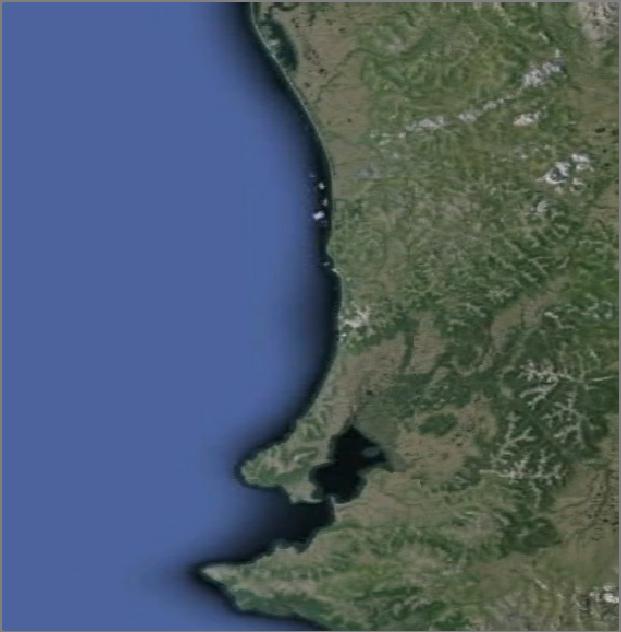
5 Alaska Deep-Draft Arctic Ports System Introduction This report documents the results of a geotechnical feasibility investigation performed to assist the selection process for adding select deep-draft arctic seaports along the west coastline of the Seward Peninsula, Alaska. The scope of the investigation was to obtain a historical perspective of the deep-draft port sites, identify geotechnical surface and subsurface conditions, and address geotechnical concerns relevant to the project. This report presents a summary of the findings based on historical documents, previous project reports, site observations, results of a field exploration and laboratory testing programs. This report also includes preliminary geotechnical engineering analysis and recommendations for breakwater structures and dredging. Before final geotechnical recommendations for the design and construction of these proposed engineering systems discussed in this report, a more extensive exploration program and detailed engineering analysis are needed. 2.0 Project Description The overall project description is to provide navigation improvements to support multiple maritime missions in the Arctic which includes Search and Rescue, Oil and Gas, Security, Cargo, Resource Export, Tourism, and emergency response. This would be accomplished by expanding, improving and/or upgrading existing ports by increasing their capacity to accommodate larger and more vessels of different lengths and drafts. This study is also considering building new ports at key location that would accommodate similar requirements. The end state of this project is to produce an efficient combination of all options available. The Alaska Deep-Draft Arctic Ports Navigation Feasibility Study, Tentatively Selected Plan SMART Planning Milestone is available upon request; see references for details. The considered locations are the Port of Nome, Point Spencer, and Cape Riley can be found on the Location and Vicinity Map; Figure 1. The focus of this will be on these three locations and the design alternatives listed below Port of Nome Design Alternatives Three design alternatives for the Port of Nome were evaluated to accommodate larger deep-draft vessels. Some deep-draft vessels that may use the port would include haul fuel barges, ice breakers, cargo barges, tankers, Coast Guard cutters, NOAA research vessels, landing crafts, and tugs. The first design alternative consisted of extending the existing causeway 2,150 feet and constructing two adjoining, 50-foot wide by 50-foot deep, concrete caisson docks; one 600-foot in length, the other 450-foot. The second design alternative consists of raising the current breakwater crest elevation from +14 feet mean lower low water (MLLW) to +25 feet MLLW.
6 Alaska Deep-Draft Arctic Ports System 2 The third design alternative is to dredge the outer channel and maneuvering area to -35 feet MLLW, and dredge between the existing causeway and main breakwater to -22 feet MLLW with an option of -35 feet MLLW. The general configuration and details of the three Nome design alternatives can be found on Figure Point Spencer Alternative The design alternative for Point Spencer to accommodate large deep-draft vessels was evaluated. This alternative would involve new construction of a 1,800-foot causeway connecting to a 50- foot wide by 50-foot deep by a 1,000-foot long caisson dock. This would also require the dredging of a turning basin and entrance channel to -35 feet MLLW. The general configuration and details of this alternative can be found on Figure Cape Riley Alternative The design alternative for Cape Riley to accommodate the necessary shallow draft mineral extraction vessels and lightering vessels was evaluated. This alternative would involve new construction of a 40-foot wide by 26-foot deep by a 250-foot long concrete caisson dock and a 200 by 360-foot staging area. This would also required the dredging of a 550-foot turning basin and 305-foot entrance channel, both to feet MLLW. The Cape Riley alternative would also include a five and a half mile road connecting to the Nome/Teller Highway. The general configuration and details of this alternative can be found on Figure Previous Studies Various geotechnical investigations have taken place in the vicinity of the Port of Nome. These investigations were performed by the U.S. Army Corps of Engineers and other agencies. All reports, maps, exploration logs, and lab data pertaining to these reports are available on request. Harding Lawson Associates (May). Soil Investigation, Port of Nome, prepared for TAMS Engineers, 4791 Business Park Boulevard, Building H, Anchorage, Alaska Woodward-Clyde Consultants (Jan). Nome Harbor Site Investigation Report, prepared for city of Nome, 3501 Denali Street, Suite 101, Anchorage, Alaska Alaska District, U.S. Army Corps of Engineers (Jan). Geotechnical Findings Report prepared for the Nome Harbor Sheet Pile Replacement Project (072742)
7 Alaska Deep-Draft Arctic Ports System 3 Alaska District, U.S. Army Corps of Engineers (May). Geotechnical Findings Report prepared for the Nome Harbor Sheet Pile Replacement Project (NOM005) No studies other than the U.S. Geological Survey investigations were available for the areas of Point Spencer and Cape Riley at the time of this feasibility study. All listed publications are available upon request. 4.0 Regional Geology Nome is situated in low lands, with elevations under 1,000 feet, located in the southwest section of the Seward Peninsula in western Alaska. This area is along the southern coast of the peninsula and bordered to the north by highlands and rolling hills with summits from 1,000 to 3,000 feet. The Snake River, a result of confluence of local streams and drainage from the highlands, divides Nome as it enters Norton Sound at the harbor site. The dominant geologic features at the site are the result of episodes of Pleistocene glaciations and attendant sea level changes. The effects of the Snake River and offshore coastal processes have also contributed to the present geologic condition. The bedrock underlying the site consists of Paleozoic micaceous schists. The rock is overlain by Pleistocene glacial and marine deposits. Point Spencer is predominantly surficial deposits. These deposits are described as undivided frost-rived (ice-moved) rubble on slopes and broad low ridges. This area is a glacial moraine and has glacially deposited sand, gravel, and boulders; fluvial gravel and sand; marine and fluvial terrace deposits; and wetlands. Cape Riley is in the middle of Grantley Harbor fault zone. This zone is weakly metamorphosed metasedi-mentary rocks with stronger deformational fabrics than those in the western Seward Peninsula, but weaker deformational fabrics than found in the Nome Complex. Primary sedimentary features are locally preserved. The small area around Cape Riley consists of intercalated grayish-green metasiltstone to medium-grained metasandstone, in layers one half inch to three feet thick, grayish-green to silver phyllite and silty phyllite, and dark gray to black phyllitic shale. Percentage of these lithologies varies throughout the outcrop belt but metasiltstone and/or metasandstone generally predominate. Some coarser grained layers appear to be graded, contain parallel laminae, and/or show local cut-and-fill structures; shaly rip-up clasts as much as an inch and a half long occur at several localities. Metasandstone and metasiltstone layers have a semi schistose texture and consist mainly of quartz, calcite, and quartz-white mica aggregates in a matrix of white mica and chlorite; lesser clast types include feldspar, dolomite, and allanite.
8 Alaska Deep-Draft Arctic Ports System Site Conditions 5.1. Port of Nome Seven test borings are in the vicinity of the proposed project footprint. These were conducted in 1982 by Harding Lawson Associates for the existing causeway. The profile fence diagram can be found in Figure 3. Most of surface soil is disturbed by construction, dredging and mining. This surface soil is composed of a medium dense to dense Holocene stratum of silty sand and gravel and ranges from two to 15 feet in thickness. Beneath this Holocene stratum there are three Pleistocene strata; glacial till, marine sand and silt, and glacial rubble over bedrock. The 1982 exploration reports a medium to very dense layer of glacial till 20 to 30 feet in thickness over the top of the dense to very dense grey marine sand and silt. Where encountered, the marine layer was found to be five to ten feet thick. Very dense rubble and bedrock were found below the marine layer. The bedrock was cored, profiled, and classified beneath the existing causeway during the 1982 exploration. The bedrock was classified as dark colored weathered micaceous Schist. The center of the channel has been dredged from -12 to -22 feet MLLW into the glacial till. Some difficulty was experience dredging to the greater depths. Previous explorations indicate the outer channel and maneuvering area has virtually the same soil material lithology; although, a slightly thicker surface deposits (Holocene) was found. A more thorough subsurface geotechnical investigation is required to better classify the subsurface conditions Point Spencer and Cape Riley No subsurface investigations or reports were available in the vicinity of Point Spencer and Cape Riley for this study. Hence, very little is known about the subsurface of these two sites. Based on U.S. Geological Survey bedrock geologic maps, the surface and subsurface is similar to Nome. Both are expected areas of glacial till shown to be overlain with out-washed surface silts and sands. Bedrock can be expected near the shore at the Cape Riley site two to five feet below the existing ground surface. A thorough subsurface geotechnical investigation will need to be performed to classify the subsurface conditions and to delineate the bedrock. 6.0 Preliminary Engineering Analysis and Recommendations 6.1. Assumptions Engineering properties for the Port Nome site were assumed using previous Nome investigation reports. Engineering properties for the Point Spencer and Cape Riley sites were conservative assumed values based on similar soils and engineering judgment. All values shown in Table 1 are for preliminary engineering analysis and should not be used for final design.
9 Alaska Deep-Draft Arctic Ports System Estimated Properties of Armor Stone For estimating purposes we have assumed a porosity (n) value of 40 percent for all of the inplace large stone products for all three sites. The specific gravity of the stone from the Cape Nome Quarry is 2.65 (Quarry Stone Test Data, Cape Nome Quarry, Nome Alaska, 5 February 1987). These test results are available upon request. To calculate the estimated dry unit weight of in-place large stone the following relationship was used between specific gravity, porosity, and the unit weight of water: 1 Estimated Dry Unit Weight lbs/ft Relative Density Speci ic Gravity, BSSD Porosity assumed 40 percent USACE Shore Protection Manual Unit Weight of water to be conservative Estimated Properties of the Constructed Fill The designs for these three sites are very similar. The constructed fill in the three designs call for Classified and Unclassified Fill under the Armor Rock layers. Classified Fill is the bulk of the fill used. For a conservative analysis, classified fill was used in all preliminary analysis. The engineering properties for the classified fill were estimated using Cornell University s Manual on Estimating Soil Properties. Effective unit weight was used in all calculations for soils below the modeled water level. Likewise, total unit weight was used above Estimated Properties of the Insitu Soils The seven test borings from the 1982 Harding Lawson Associates Soil Investigation from the initial Nome Harbor Investigation shows the engineering properties of the subsurface soils improve the deeper the material. The location of these test borings are shown on Figure 2. A profile fence diagram constructed from these boring is shown on Figure 3. The coarse grained surface layer can be up to 15 feet thick; therefore, the engineering properties of this layer is used for all preliminary analysis of the subsurface insitu soil for all three sites.
10 Alaska Deep-Draft Arctic Ports System 6 Table 1. Assumed engineering properties for Nome, Point Spencer and Cape Riley. Material Dry Unit Weight (pcf) Phi ( ) Effective Unit Weight (pcf) Stone Armor Constructed Fill Insitu soil unit Assume Density of Seawater All soils are considered non cohesive Preliminary Analysis The following analysis was completed referencing EM , Stability Analysis of Concrete Structures; EM , Retaining and Flood Walls; EM Part VI, Introduction to Coastal Project Element Design, EM , Bearing Capacity of Soils, and EM , Engineering and Design Slope Stability. The design criteria can be found in Table 2. The critical cases for all design features were evaluated. The Simplified Bishop Method was used to determine all the slope stability analysis performed in this section. The analysis was performed using a spreadsheet and hand calculations. A more in-depth computer model should be developed using further soil investigations and a computer analysis (Spenser method) should be conducted for final design. Table 2. Design criteria for project features. Design Feature Source Publication Safety Factor Slope Stability EM Bearing Capacity EM Sliding EM Overturning EM Usual (100% of Base in Compression) Port of Nome The proposed Nome causeway extension with the concrete caissons and new proposed crest elevation for the existing breakwater have been analyzed for slope stability and the proposed caisson docks have been analyzed for global stability. The Simplified Bishop Method was used to determine the slope stability of the causeway and breakwater; geometry can be found on Figure 4. Using the assumptions in Table 1 and an embankment elevation of feet MLLW,
11 Alaska Deep-Draft Arctic Ports System 7 on a 2 horizontal to 1 vertical slope, a factor of safety against slope failure of the causeway was 2.0. Increasing the breakwater crest to an elevation of +25 feet MLLW and maintaining the same critical 1.5 horizontal to 1 vertical slope results in a computed factor of safety of 1.3. A more indepth computer model and analysis should be conducted for design subsequent to further soils investigation. The global stability to include bearing capacity, sliding and overturning was calculated for the concrete caisson dock for Nome. The internal stability is assumed to be accounted in the design of the caisson structure itself. The 600 by 50 by 50-foot caisson has a design embedment of two feet; this is ignored for conservative analysis. Rotational behavior is satisfactory due to all resultant applied forces with respect to the potential failure plane are in compression for this usual load condition. Further safety is ensured by the safety factor requirements for sliding and by the limits on allowable bearing stresses. From the design and performance of the existing Nome Causeway and Breakwater, settlement is the controlling limit state at an allowable bearing pressure of 5,000 pounds per square foot. Also note, this allowable bearing pressure is used for Point Spencer and Cape Riley s analysis. Using this value and the assumed values in table 1, the calculated bearing pressure was 3,630 pounds per square foot. The resulting bearing capacity factor of safety is 4.1. The factor of safety for sliding was calculated to be Point Spencer The proposed Point Spencer causeway with the caisson dock has been analyzed for slope stability. The caisson dock has been analyzed for global stability. The Simplified Bishop Method was used to determine the slope stability of the causeway; geometry can be found on Figure 6. Using the assumptions in Table 1 and a causeway elevation of feet MLLW, on a 1.5 horizontal to 1 vertical slope, a factor of safety against slope failure was 1.9. A more in-depth computer model and analysis should be conducted for design subsequent to further soils investigation. The maximum bearing pressure for the critical section of the purposed causeway is 3,100 pounds per square foot. The sub grade has an allowable bearing capacity of 5,000 pounds per square foot resulting in a bearing capacity factor of safety of 4.8. The external global stability to include bearing capacity, sliding and overturning was calculated for the concrete caisson dock for Point Spencer. The internal stability is assumed to be accounted in the design of the caisson structure itself. Almost identical design as the Nome caisson, except for its length, the 1000 by 50 by 50-foot caisson also has a design embedment of two feet. This two-foot embedment was ignored for conservative analysis. Rotational behavior is satisfactory due to all the resultant applied forces with respect to the potential failure plane are in compression for this usual load condition. Further safety is ensured by the safety factor requirements for sliding and by the limits on allowable bearing stresses. Using the assumed values in Table 1 and an allowable bearing capacity of 5,000 pounds per square foot, the
12 Alaska Deep-Draft Arctic Ports System 8 calculated bearing pressure of the caisson dock structure was 3,630 pounds per square foot resulting in a bearing capacity factor of safety of 4.1. The factor of safety for sliding is Cape Riley The proposed Cape Riley breakwater has been analyzed for bearing pressure capacity and considered for slope stability. The caisson dock has been analyzed for global stability. The breakwater compared to the Point Spencer Breakwater has the same preliminary design and geometry; however, it has less relative height and less overall material, resulting in a less significant load on the insitu soils. Therefore, the factor of safety against slope failure is greater than Point Spencer s 1.9. A more in-depth computer model and analysis should be conducted for design subsequent to further soils investigation. The maximum bearing pressure for the critical section of the purposed breakwater is 2,600 pounds per square foot; the sub grade has an allowable bearing capacity of 5,000 pounds per square foot resulting in a bearing capacity factor of safety of 5.8. The external global stability to include bearing capacity, sliding and overturning was calculated for the concrete caisson dock at Cape Riley. The internal stability is assumed to be accounted in the design of the caisson structure itself. The 250 by 40 by 26-foot caisson has a design embedment of two feet. This two-foot embedment was ignored for conservative analysis. Rotational behavior is satisfactory due to all the resultant applied forces with respect to the potential failure plane are in compression for this usual load condition. Further safety is ensured by the safety factor requirements for sliding and by the limits on allowable bearing stresses. Using the assumed values in Table 1, the calculated bearing pressure is 1,600 pounds per square foot. The sub grade has an allowable bearing capacity of 5,000 pounds per square foot resulting in a bearing capacity factor of safety of 9.4. Factor of safety for sliding is Preliminary Engineering Recommendations Preliminary engineering analysis shows the project sites are suitable for the construction of the proposed project options. Recommendations presented in this section are meant as preliminary engineering recommendations for the elements outlined in this feasibility report. The zone of influence for settlement is two times the width of the caisson; for Nome and Point Spenser it is 100 feet and 52 feet for Cape Riley. Assuming the soil characteristics are the same as found in the 1982 Nome soil investigation, the subsurface soil is a coarse grained, medium dense non-cohesive soil, and becomes very dense to bedrock. Following these assumptions, we do not anticipate excessive settlement. By inspection of previous like construction in the vicinity of Nome, all settlement will be minimal and occur during construction. A more in-depth geotechnical investigation should be conducted and updated recommendation should be prepared in the event that this project is brought to 100 percent design.
13 Alaska Deep-Draft Arctic Ports System 9 The medium dense silty sand and gravel soils at all three site would allow a variety of excavation methods to be used. This includes excavators from barge or clam shell in which both of these methods have been successful in the Port of Nome. Some difficulty dredging was encountered in the area between the causeway and the main breakwater at a depth of approximately -20 feet MLLW near mid-channel in the glacial till. Clam shell dredging should be considered for dredging the deeper channel. Localized areas at Cape Riley, shallow bedrock may impede normal dredging. For these areas, blasting may be necessary. A stable channel side slope should be no steeper than 3 horizontal to 1 vertical slope at an offset of no less than 25 feet from the toe of any breakwater or causeway. This offers protection against the breakwater or causeway failing the dredge slope. The worsted case at a 25-foot offset offers a factor of safety of 1.4 against slope failure. The medium dense silty sand and gravel soils at all three sites will not likely remain in place after construction. If cut slopes are steeper than 3 horizontal to 1 vertical slope, it is recommended to protect channel side slopes with armor rock.
14 Alaska Deep-Draft Arctic Ports System References U.S. Geological Survey. (2011). Bedrock Geologic Map of the Seward Peninsula Pamphlet and accompanying Maps ( and 2). N.p.: U.S. Department of the Interior. U.S. Army Coastal Engineering Research Center. (1977). Shore Protection Manual (III ed., Vol. II, pp ). Washington DC: U.S. Government Printing Office. U.S. Army Corps of Engineers. (1992). EM , Engineering and Design BEARING CAPACITY OF SOILS. Washington, D.C.: U.S. Department of the Army. U.S. Army Corps of Engineers. (2002). EM , Coastal Engineering Manual - Part V. Washington, D.C.: U.S. Department of the Army. U.S. Army Corps of Engineers. (2003) , Engineering and Design SLOPE STABILITY. Washington, DC: U.S. Department of the Army. U.S. Army Corps of Engineers. (1998). EM , Engineering and Design RETAINING AND FLOOD WALLS. Washington, D.C.: U.S. Department of the Army. Cornell University. (1990). Chapter 2. In Manual on Estimating Soil Properties for Foundation Designs. Washington, D.C.: Electric Power Research Institute. Harding Lawson Associates. (1982). Soil Investigation Report for Port of Nome. Anchorage, AK: TAMS Engineers. Woodward-Clyde Consultants. (n.d.). Nome Harbor Site Investigation Report. Anchorage, AK: City of Nome.. (2004). Geotechnical Findings Report for the Nome Harbor Sheet Pile Replacement Project (072742). Anchorage, AK: Geotechnical and Materials.. (2006). Geotechnical Findings Report for the Nome Harbor Sheet Pile Replacement Project (NOM005). Anchorage, AK: Geotechnical and Materials.. (2013). Alaska Deep-Draft Arctic Ports Navigation Feasibility Study. In Tentatively Selected Plan SMART Planning Milestone (pp. 1-42).
15
16
17
18
19
20
21
1-32 NOME HARBOR, ALASKA (CWIS NOS , 87755, & 10422) Condition of Improvement 30 September 2009
 Condition of Improvement 30 September 2009") NOME HARBOR 1-32 NOME HARBOR, ALASKA (CWIS NOS. 72742, 87755, & 10422) Condition of Improvement 30 September 2009 AUTHORIZATION: (1) Rivers and Harbors Act, 8 August 1917 (House Doc. 1932, 64th Congress,
NOME HARBOR 1-32 NOME HARBOR, ALASKA (CWIS NOS. 72742, 87755, & 10422) Condition of Improvement 30 September 2009 AUTHORIZATION: (1) Rivers and Harbors Act, 8 August 1917 (House Doc. 1932, 64th Congress,
1-32 NOME HARBOR, ALASKA (CWIS NOS , 87755, 12270, & 10422) Condition of Improvement 30 September 2012
 Condition of Improvement 30 September 2012") NOME HARBOR 1-32 NOME HARBOR, ALASKA (CWIS NOS. 72742, 87755, 12270, & 10422) Condition of Improvement 30 September 2012 AUTHORIZATION: (1) Rivers and Harbors Act, 8 August 1917 (House Doc. 1932, 64th
NOME HARBOR 1-32 NOME HARBOR, ALASKA (CWIS NOS. 72742, 87755, 12270, & 10422) Condition of Improvement 30 September 2012 AUTHORIZATION: (1) Rivers and Harbors Act, 8 August 1917 (House Doc. 1932, 64th
REPORT GEO-TECHNICAL INVESTIGATION FOR THE PROPOSED BLOCK-1 SUB-STATION SY NO-44, NEAR KYATAGANACHERLU VILLAGE
 REPORT ON GEO-TECHNICAL INVESTIGATION FOR THE PROPOSED BLOCK-1 SUB-STATION SY NO-44, NEAR KYATAGANACHERLU VILLAGE CLIENT: KARNATAKA SOLAR POWER DEVELOPMENT CORPORATION BANGALORE 0 GEO-TECHNICAL INVESTIGATION
Nome Harbor Page 2 of 12
 Nome Harbor Nome Harbor Page 2 of 12 Condition of Improvements 30 December 2015 Nome Harbor, Alaska (CWIS No. 010422, 012270, 072742, 087755) Authorization (1) Rivers and Harbors Act, 8 August 1917 (House
REPORT GEO-TECHNICAL INVESTIGATION FOR THE PROPOSED BLOCK-7 SUB-STATION SY NO-225, NEAR RAYACHERLU VILLAGE
 REPORT ON GEO-TECHNICAL INVESTIGATION FOR THE PROPOSED BLOCK-7 SUB-STATION SY NO-225, NEAR RAYACHERLU VILLAGE CLIENT: KARNATAKA SOLAR POWER DEVELOPMENT CORPORATION BANGALORE 0 GEO-TECHNICAL INVESTIGATION
REVETMENTS. Purposes and Operational Constraints. Purposes Erosion control o o. Revetment Design 4/5/2016. CE A676 Coastal Engineering
 REVETMENTS Ijsseldam, the Netherlands Orson P. Smith, PE, Ph.D. Instructor Purposes and Operational Constraints Purposes Erosion control o o Embankment Toe protection for a seawall, retaining wall or other
TYPES OF FOUNDATION. Superstructure. Substructure. Foundation
 TYPES OF FOUNDATION Introduction: The lowest artificially built part of a structure which transmits the load of the structure to the soil lying underneath is called foundation. The supporting part of a
ITEM 400 STRUCTURAL EXCAVATION AND BACKFILL
 AFTER MARCH 1, 2012 ITEM 400 STRUCTURAL EXCAVATION AND BACKFILL 400.1 Description. This item shall govern for all excavation required for the construction of all structures, except pipe or box sewers for
OECS Regional Engineering Workshop September 29 October 3, 2014
 B E A C H E S. M A R I N A S. D E S I G N. C O N S T R U C T I O N. OECS Regional Engineering Workshop September 29 October 3, 2014 Coastal Erosion and Sea Defense: Introduction to Coastal/Marine Structures
APPENDIX C VEGETATED EMERGENCY SPILLWAY. VERSION 1.0 March 1, 2011
 APPENDIX C VEGETATED EMERGENCY SPILLWAY VERSION 1.0 March 1, 2011 [NOTE: Could use a better photo more clearly showing the emergency spillway in the context of the dam.] SECTION C-1: DESCRIPTION OF PRACTICE
Nearshore Dredged Material Placement Pilot Study at Noyo Harbor, CA
 1 Nearshore Dredged Material Placement Pilot Study at Noyo Harbor, CA Noyo Cove N 2011 National Conference on Beach Preservation Technology 9-11, February 2011 Lihwa Lin, Honghai Li, Mitchell Brown US
(Refer Slide Time: 1:01)
") Port and Harbour Structures. Professor R. Sundaradivelu. Department of Ocean Engineering. Indian Institute of Technology, Madras. Module-3. Lecture-11. Breakwater. So we have so far discussed 5 lectures,
Port and Harbour Structures. Professor R. Sundaradivelu. Department of Ocean Engineering. Indian Institute of Technology, Madras. Module-3. Lecture-11. Breakwater. So we have so far discussed 5 lectures,
October 16, GRDA CCR Landfill Compliance Report Grand River Dam Energy Center 8142 Hwy 412B PO Box 609 Chouteau, OK Dear Mr.
 October 16, 2018 Mr. Mike Bednar Superintendent of Environmental Compliance GRDA-Ecosystems and Education Center PO Box 70 420 Hwy 28 Langley, OK 74350-0070 RE: GRDA CCR Landfill Compliance Report Grand
Beach Nourishment Impact on Beach Safety and Surfing in the North Reach of Brevard County, Florida
 Beach Nourishment Impact on Beach Safety and Surfing in the North Reach of Brevard County, Florida Prepared by John Hearin, Ph.D. Coastal Engineering Vice Chairman Cocoa Beach Chapter Port Canaveral Patrick
UNIT-I SOIL EXPLORATION
 SIDDHARTH GROUP OF INSTITUTIONS :: PUTTUR Siddharth Nagar, Narayanavanam Road 517583 QUESTION BANK (DESCRIPTIVE) Subject with Code : Geotechnical Engineering - II (16CE127) Year & Sem: III-B.Tech & II-Sem
Unalaska Navigation Channel Improvements
 1 237 237 237 255 255 255 0 0 0 Unalaska Navigation Channel Improvements 217 217 217 200 200 200 163 163 163 131 132 122 239 65 53 80 119 27 252 174.59 110 135 120 112 92 56 62 102 130 102 56 48 130 120
SUMMARY OF SUBSURFACE STRATIGRAPHY AND MATERIAL PROPERTIES
 Page 1 of 101 Written by: Ming Zhu Date: 08/20/2008 Reviewed by: R. Kulasingam/J. Beech Date: 08/20/2008 SUMMARY OF SUBSURFACE STRATIGRAPHY AND MATERIAL PROPERTIES 1. INTRODUCTION This Summary of Subsurface
Juneau Douglas Harbor
 Juneau Douglas Harbor Douglas Harbor Page 2 of 8 Condition of Improvements 31 December 2015 Douglas Harbor, Alaska (CWIS No. 072789, 180942) Authorization Rivers and Harbors Act, 3 July 1958 (House Doc.
Structure Failure Modes
 US Army Corps Monitoring and Maintenance of Coastal Infrastructure Structure Failure Modes Steven A. Hughes, PhD, PE Coastal and Hydraulics Laboratory US Army Engineer Research and Development Center Waterways
Soft Designs for a Harsh Climate: Trends in Coastal Engineering
 Alaska Department of Transportation & Public Facilities Ruth Carter, PE, and Harvey Smith, PE Coastal Engineering Section 20 October 2014 Soft Designs for a Harsh Climate: Trends in Coastal Engineering
Low-crested offshore breakwaters: a functional tool for beach management
 Environmental Problems in Coastal Regions VI 237 Low-crested offshore breakwaters: a functional tool for beach management K. Spyropoulos & E. Andrianis TRITON Consulting Engineers, Greece Abstract Beach
CROSS-SHORE SEDIMENT PROCESSES
 The University of the West Indies Organization of American States PROFESSIONAL DEVELOPMENT PROGRAMME: COASTAL INFRASTRUCTURE DESIGN, CONSTRUCTION AND MAINTENANCE A COURSE IN COASTAL DEFENSE SYSTEMS I CHAPTER
Construction Dewatering
 Construction Dewatering Introduction The control of groundwater is one of the most common and complicated problems encountered on a construction site. Construction dewatering can become a costly issue
INSTITUTE OF AERONAUTICAL ENGINEERING (Autonomous) Dundigal, Hyderabad
 Dundigal, Hyderabad") INSTITUTE OF AERONAUTICAL ENGINEERING (Autonomous) Dundigal, Hyderabad - 500 043 CIVIL ENGINEERING Tutorial Question Bank Name : FOUNDATION ENGINEERING Code : A60126 Class : III B. Tech II Semester Branch
INSTITUTE OF AERONAUTICAL ENGINEERING (Autonomous) Dundigal, Hyderabad - 500 043 CIVIL ENGINEERING Tutorial Question Bank Name : FOUNDATION ENGINEERING Code : A60126 Class : III B. Tech II Semester Branch
Annex E Bridge Pier Protection Plan
 Annex E Bridge Pier Protection Plan Table E1 Bridge Types and Locations Table E2 Flow Conditions For River Sections Figure E1 Bridge Abutment Protection Figure E2 Bridge Pier Protection Figure E3 Central
Ocean Structures and Material Prof. Dr. Srinivasan Chandrasekaran Department of Ocean Engineering Indian Institute of Technology, Madras
 Ocean Structures and Material Prof. Dr. Srinivasan Chandrasekaran Department of Ocean Engineering Indian Institute of Technology, Madras Module - 2 Lecture - 5 Dredging II In the fifth lecture we discussed
BILLY BISHOP TORONTO CITY AIRPORT PRELIMINARY RUNWAY DESIGN COASTAL ENGINEERING STUDY
 Bâtiment Infrastructures municipales Transport Industriel Énergie Environnement BILLY BISHOP TORONTO CITY AIRPORT PRELIMINARY RUNWAY DESIGN COASTAL ENGINEERING STUDY N. Guillemette 1, C. Glodowski 1, P.
1-44. SITKA HARBOR, ALASKA (Western Channel, Crescent Bay Basin, Channel Rock Breakwaters) (CWIS NOS , 16840, 10322, 55030, 13787)
 (CWIS NOS , 16840, 10322, 55030, 13787)") SITKA 1-44 SITKA HARBOR, ALASKA (Western Channel, Crescent Bay Basin, Channel Rock Breakwaters) (CWIS NOS. 72845, 16840, 10322, 55030, 13787) Condition of Improvement 30 September 2011 AUTHORIZATION:
SITKA 1-44 SITKA HARBOR, ALASKA (Western Channel, Crescent Bay Basin, Channel Rock Breakwaters) (CWIS NOS. 72845, 16840, 10322, 55030, 13787) Condition of Improvement 30 September 2011 AUTHORIZATION:
Pacific Ocean Division. Navigation Program Overview. Association of Pacific Ports 2016 Winter Conference Waikaloa, Hawaii.
 Pacific Ocean Division Navigation Program Overview Association of Pacific Ports 2016 Winter Conference Waikaloa, Hawaii David Lau Pacific Ocean Division Chief, Civil Works Integration Division January
APPENDIX D REAL ESTATE PLAN
 NAVIGATION IMPROVEMENTS SITKA HARBOR, ALASKA CHANNEL ROCK BREAKWATERS DRAFT DEFICIENCY CORRECTION EVALUATION REPORT APPENDIX D REAL ESTATE PLAN JANUARY 2011 REAL ESTATE PLAN FOR SITKA HARBOR, ALASKA CHANNEL
Redondo Beach Boat Launch Ramp Facility
 Redondo Beach Boat Launch Ramp Facility Feasibility Report for the California Department of Boating and Waterways 2015 Grant Cycle For the City of Redondo Beach Submitted by March 13, 2014 Table of Contents
Condition of Improvements 30 December 2014 Wrangell Harbors, Alaska (CWIS No , )
") Wrangell Harbors Condition of Improvements 30 December 2014 Wrangell Harbors, Alaska (CWIS No. 010435, 021500) Authorization (1) Rivers and Harbors Act, 22 September 1922 (House Doc. 161, 67th Congress,
Wrangell Harbors Condition of Improvements 30 December 2014 Wrangell Harbors, Alaska (CWIS No. 010435, 021500) Authorization (1) Rivers and Harbors Act, 22 September 1922 (House Doc. 161, 67th Congress,
3. Types of foundation
 Foundation Engineering CE 48. Types of foundation & foundation materials Contents Introduction Shallow Foundations Deep Foundations Introduction Why different types of? General types of Introduction Why
CENGRS GEOTECHNICA PVT. LTD. Job No Sheet No. 1
 CENGRS GEOTECHNICA PVT. LTD. Job No. 214030 Sheet No. 1 INTERIM REPORT ON GEOTECHNICAL INVESTIGATION FOR PROPOSED 66 KV GRID PLOT AT G-7, DWARKA, NEW DELHI. 1.0 INTRODUCTION 1.1 Project Description M/s.
 FIGURES APPENDIX A SYMBOL SAMPLING DESCRIPTION Location of sample obtained in general accordance with ASTM D 1586 Standard Penetration Test with recovery Location of sample obtained using thin-wall
DRAFT. October 17, 2014 File No Mr. Brendhan Zubricki Town Administrator Essex Town Hall 30 Martin Street Essex, MA.
 GZA GeoEnvironmental, Inc. Engineers and Scientists October 17, 2014 File No. 18.0171857.00 Mr. Brendhan Zubricki Town Administrator Essex Town Hall 30 Martin Street Essex, MA. 01929 DRAFT Re: Essex River
m v = 1.04 x 10⁻⁴ m 2 /kn, C v = 1.29 x 10⁻² cm 2 /min
 2.10 Problems Example 2.1: Design of Shallow Foundation in Saturated Clay Design a square footing to support a column load of 667 kn. The base of the footing will be located 1 m below the ground level
Chapter 10 Lecture Outline. The Restless Oceans
 Chapter 10 Lecture Outline The Restless Oceans Focus Question 10.1 How does the Coriolis effect influence ocean currents? The Ocean s Surface Circulation Ocean currents Masses of water that flow from one
Port of Zeebrugge: Upgrading the Brittannia Dock
 ABSTRACT Port of Zeebrugge: Upgrading the Brittannia Dock by L. Missinne 1 and L. Van Damme 2 The Flemish authority started with the upgrading of the Brittannia Dock in the port of Zeebrugge. The Brittannia
INSTITUTE OF AERONAUTICAL ENGINEERING (Autonomous) Dundigal, Hyderabad CIVIL ENGINEERING TUTORIAL QUESTION BANK
 Dundigal, Hyderabad CIVIL ENGINEERING TUTORIAL QUESTION BANK") INSTITUTE OF AERONAUTICAL ENGINEERING (Autonomous) Dundigal, Hyderabad - 00 04 CIVIL ENGINEERING TUTORIAL QUESTION BANK Course Name Course Code Regulation Course Structure Course Coordinator Course Faculty
INSTITUTE OF AERONAUTICAL ENGINEERING (Autonomous) Dundigal, Hyderabad - 00 04 CIVIL ENGINEERING TUTORIAL QUESTION BANK Course Name Course Code Regulation Course Structure Course Coordinator Course Faculty
Feasibility Report and Environmental Impact Statement. Coastal Storm Damage Reduction SURF CITY AND NORTH TOPSAIL BEACH, NORTH CAROLINA.
 Feasibility Report and Environmental Impact Statement on Coastal Storm Damage Reduction SURF CITY AND NORTH TOPSAIL BEACH, NORTH CAROLINA Appendix H Correspondence Appendix H Correspondence This appendix
What prompted the collapse of the Chirajara Bridge?
 What prompted the collapse of the Chirajara Bridge? Translated by: BENJAMIN SANDOVAL GIL Professional Engineer 11070 Katy Fwy Apt 1480 Houston, TX 77043 Cel. (787) 439-0883 bsand56855@gmail.com E'Huang
Imagine that you can see a side view of a wave as it approaches a beach. Describe how the wave changes as the wave approaches the beach.
 Geology 101 Name Reading Guide for Ch. 19: Shores and Coastal Processes (p. 612) Waves, Currents, and Tides (p. 614) Waves and Currents (p. 614) Imagine that you can see a side view of a wave as it approaches
COASTAL ENVIRONMENTS. 454 lecture 12
 COASTAL ENVIRONMENTS Repeated movement of sediment & water constructs a beach profile reflecting the balance between average daily or seasonal wave forces and resistance of landmass to wave action Coasts
Coastal Harbors and Waterways, NC (Shallow Draft Navigation) (O&M)
 (O&M)") Coastal Harbors and Waterways, NC (Shallow Draft Navigation) (O&M) Shallow draft coastal harbors include a subsistence harbor at Silver Lake CONGRESSIONAL DISTRICT: NC 3 and 7 DATE: 23 February 2015 1.
Coastal Harbors and Waterways, NC (Shallow Draft Navigation) (O&M) Shallow draft coastal harbors include a subsistence harbor at Silver Lake CONGRESSIONAL DISTRICT: NC 3 and 7 DATE: 23 February 2015 1.
CHAPTER 134 INTRODUCTION
 CHAPTER 134 NEW JETTIES FOR TUNG-KANG FISHING HARBOR, TAIWAN Chi-Fu Su Manager Engineering Department Taiwan Fisheries Consultants, Inc. Taipei, Taiwan INTRODUCTION Tung-Kang Fishing Harbor, which is about
Item 404 Driving Piling
 Item Driving Piling 1. DESCRIPTION Drive piling. 2. EQUIPMENT 2.1. Driving Equipment. Use power hammers for driving piling with specified bearing resistance. Use power hammers that comply with Table 1.
Chapter 4 EM THE COASTAL ENGINEERING MANUAL (Part I) 1 August 2008 (Change 2) Table of Contents. Page. I-4-1. Background...
 1 August 2008 (Change 2) Table of Contents. Page. I-4-1. Background...") Chapter 4 EM 1110-2-1100 THE COASTAL ENGINEERING MANUAL (Part I) 1 August 2008 (Change 2) Table of Contents I-4-1. Background... Page I-4-1 a. Shore Protection Planning and Design, TR 4... I-4-1 b. Shore
Chapter 4 EM 1110-2-1100 THE COASTAL ENGINEERING MANUAL (Part I) 1 August 2008 (Change 2) Table of Contents I-4-1. Background... Page I-4-1 a. Shore Protection Planning and Design, TR 4... I-4-1 b. Shore
Cordova Harbor Page 2 of 9
 Cordova Harbor Cordova Harbor Page 2 of 9 Condition of Improvements 30 December 2017 Cordova Harbor, Alaska (CWIS No. 087136, 087186, 087711) Authorization Rivers and Harbors Act, 30 August 1935 (R & H
Juneau Aurora Harbor
 Juneau Aurora Harbor Aurora Harbor Page 2 of 6 Condition of Improvements 31 December 2017 Aurora Harbor Juneau, Alaska (CWIS No. 020960) Authorization Rivers and Harbors Act, 3 July 1958 (House Doc. 286,
The Challenge of Wave Scouring Design for the Confederation Bridge
 13: Coastal and Ocean Engineering ENGI.8751 Undergraduate Student Forum Faculty of Engineering and Applied Science, Memorial University, St. John s, NL, Canada MARCH 2013 Paper Code. (13 - walsh) The Challenge
STRUCTURAL STABILITY ASSESSMENT
 STRUCTURAL STABILITY ASSESSMENT CFR 257.73(d) Fly Ash Reservoir II Cardinal Plant Brilliant, Ohio October, 2016 Prepared for: Cardinal Operating Company Cardinal Plant Brilliant, Ohio Prepared by: Geotechnical
SITE S7: EMBANKMENT FAILURE WEST OF MILLARVILLE
 LANDSLIDE RISK ASSESSMENT SOUTHERN REGION SITE S7: EMBANKMENT FAILURE WEST OF MILLARVILLE LEGAL LOCATION: LSD 4-3-21-4 W5M and 1-4-21-4 W5M REFERENCE LOCATION ALONG HIGHWAY The slide area is located between
HISTORY OF CONSTRUCTION
 HISTORY OF CONSTRUCTION CFR 257.73(c)(1) West Boiler Slag Pond Clifty Creek Plant Madison, Indiana October, 2016 Prepared for: Indiana Kentucky Electric Corporation Prepared by: American Electric Power
Cook Inlet pipeline crossing is about making the best choices
 Cook Inlet pipeline crossing is about making the best choices By Larry Persily lpersily@kpb.us Aug. 26, 2015 (This update, provided by the Kenai Peninsula Borough mayor s office, is part of an ongoing
Figure 1. Schematic illustration of the major environments on Mustang Island.
 STOP #1: PACKERY CHANNEL BEACH TO BAY We will start this field guide near the north jetty of Packery Channel and hike across the island to Corpus Christi Bay (fig. 1). The island emerges from the Gulf
APPENDIX J HYDROLOGY AND WATER QUALITY
 APPENDIX J HYDROLOGY AND WATER QUALITY J-1 Technical Report on Airport Drainage, Northern Sector Airport and Ordinance Creek Watershed / Preliminary Creek Constructed Natural Channel Culvert J-2 Preliminary
Ennore Coal Port Project: Port Basin and Entrance Channel
 Ennore Coal Port Project: Port Basin and Entrance Channel André Luypaert Ennore Coal Port Project: Port Basin and Entrance Channel Abstract The Chennai Port on the eastern coast of India is the main port
Bridge Design Preliminary Bridge Design Example 1 / 6 Spring 2012 updated 1/27/2012
 Bridge Design Preliminary Bridge Design Example 1 / 6 Perform a preliminary design for a bridge on a state highway over a large creek in rural Alabama. Produce a construction layout drawing showing profile
Coastal Harbors and Waterways, NC (Shallow Draft Navigation) (O&M)
 (O&M)") Coastal Harbors and Waterways, NC (Shallow Draft Navigation) (O&M) Shallow draft coastal harbors include a subsistence harbor at Silver Lake CONGRESSIONAL DISTRICT: NC 3 and 7 DATE: 23 February 2015 1.
Coastal Harbors and Waterways, NC (Shallow Draft Navigation) (O&M) Shallow draft coastal harbors include a subsistence harbor at Silver Lake CONGRESSIONAL DISTRICT: NC 3 and 7 DATE: 23 February 2015 1.
Chapter 22, Section 1 - Ocean Currents. Section Objectives
 Chapter 22, Section 1 - Ocean Currents Section Objectives Intro Surface Currents Factors Affecting Ocean Currents Global Wind Belts (you should draw and label a diagram of the global wind belts) The Coriolis
Eelgrass and Macroalgae Presence/Absence Preliminary Surveys BHP Proposed Grays Harbor Potash Export Facility A Task 400
 Memorandum 40600-HS-MEM-55036 Revision 0 Date: 26 July 2018 Subject: Eelgrass and Macroalgae Presence/Absence Preliminary Surveys BHP Proposed Grays Harbor Potash Export Facility A17.0202.00 Task 400 INTRODUCTION
APPENDIX D-2. Sea Level Rise Technical Memo
 APPENDIX D-2 Sea Level Rise Technical Memo 2185 N. California Blvd., Suite 500 Walnut Creek, CA 94596 (925) 944-5411 Fax: (925) 944-4732 www.moffattnichol.com DRAFT MEMORANDUM To: From: Neil Nichols,
Ninilchik Harbor Page 2 of 11
 Ninilchik Harbor Ninilchik Harbor Page 2 of 11 Condition of Improvements 31 December 2017 Ninilchik Harbor, Alaska (CWIS No. 012640, 087345) Authorization Rivers and Harbors Act, 3 July 1958 (P.L. 85-500
Utilizing Vessel Based Mobile LiDAR & Bathymetry Survey Techniques for Survey of Four Southern California Breakwaters
 Utilizing Vessel Based Mobile LiDAR & Bathymetry Survey Techniques for Survey of Four Southern California Breakwaters Western Dredging Association: Pacific Chapter September 2012 Insert: Pipe Location
TACKLING JACK-UP RIG NO-GO LOCATIONS. Prakasha Kuppalli ABSTRACT
 TACKLING JACK-UP RIG NO-GO LOCATIONS Prakasha Kuppalli ABSTRACT Jack-up rigs are deployed for drilling and work-over (maintenance) of offshore oil and gas wells for producing hydrocarbons. Rigs drill through
R. Randall Center for Dredging Studies Texas A&M University
 R. Randall Center for Dredging Studies Texas A&M University i Glory (Caisson) holes for subsea installations Pipeline trenches Deep ocean mining LNG ports & ship channels Summary WEDA 33 & TAMU 44 2 WEDA
Breakwaters and closure dams CT 5308 Exercise 2011: Pointe Noire, Congo
 Breakwaters and closure dams CT 5308 Exercise 2011: Pointe Noire, Congo The town of Pointe Noire is the main port city in the Republic of the Congo and sits on the south-western African coast some 150
TECHNICAL MEMORANDUM 002 EMORANNO. 001
 TECHNICAL MEMORANDUM 002 EMORANNO. 001 To: Jack Synder, P.E. EES Consulting From: Mort McMillen, P.E. Paul Larson, SE Date: October 13, 2010 Project: Cc: Taylor Bowen Subject: Technical Memorandum (TM)
PUSH PIER SYSTEMS STABILITY. SECURITY. INTEGRITY. Push Pier Systems PN #MBPPT
 PUSH PIER SYSTEMS STABILITY. SECURITY. INTEGRITY. PN #MBPPT Push Pier Systems About Foundation Supportworks is a network of the most experienced and knowledgeable foundation repair and new construction
La Quinta Channel Extension Port of Corpus Christi Ingleside, Texas. Mark Coyle
 La Quinta Channel Extension Port of Corpus Christi Ingleside, Texas Mark Coyle Corpus Christi Navigation Channel PCCA La Quinta Expansion Project History Corpus Christi Ship Channel Improvement Projects
Pore-Air Entrapment during Infiltration
 Pore-Air Entrapment during Infiltration GEO-SLOPE International Ltd. www.geo-slope.com 1200, 700-6th Ave SW, Calgary, AB, Canada T2P 0T8 Main: +1 403 269 2002 Fax: +1 888 463 2239 Introduction Infiltration
Grays Harbor O&M and Deepening Dredging
 Grays Harbor O&M and Deepening Dredging Elizabeth Chien Project Manager Seattle District 28 January 2016 US Army Corps of Engineers Grays Harbor Navigation Channel Inner Harbor O&M Dredging Summer 2015:
General Coastal Notes + Landforms! 1
 General Coastal Notes + Landforms! 1 Types of Coastlines: Type Description Primary Coast which is essentially in the same condition when sea level stabilized Coastline after the last ice age, younger.
HURRICANE SANDY LIMITED REEVALUATION REPORT UNION BEACH, NEW JERSEY DRAFT ENGINEERING APPENDIX SUB APPENDIX D SBEACH MODELING
 HURRICANE SANDY LIMITED REEVALUATION REPORT UNION BEACH, NEW JERSEY DRAFT ENGINEERING APPENDIX SUB APPENDIX D SBEACH MODELING Rev. 18 Feb 2015 1 SBEACH Modeling 1.0 Introduction Following the methodology
Northern Indiana Public Service Company Michigan City Generating Station Primary Settling Pond Number Annual RCRA CCR Unit Inspection Report
 REPORT Northern Indiana Public Service Company Michigan City Generating Station Primary Settling Pond Number 2 2018 Annual RCRA CCR Unit Inspection Report Submitted to: Northern Indiana Public Service
MSC Guidelines for the Review of Oil Spill Response Vessels (OSRV), Lightship and Stability
, Lightship and Stability") R. J. LECHNER, CDR, Chief, Tank Vessel and Offshore Division Purpose This Plan Review Guidance (PRG) explains the requirements for seeking plan approval for stability plans and calculations from the Marine
R. J. LECHNER, CDR, Chief, Tank Vessel and Offshore Division Purpose This Plan Review Guidance (PRG) explains the requirements for seeking plan approval for stability plans and calculations from the Marine
City of Port Aransas Shoreline Analysis and Improvements
 City of Port Aransas Shoreline Analysis and Improvements FINAL Technical Report August 24, 2016 Submitted To: City of Port Aransas Prepared for: City of Port Aransas This document is intended for planning
CORPS FACTS. Harbor Dredging U.S. ARMY CORPS OF ENGINEERS BUILDING STRONG
 CORPS FACTS Harbor Dredging U.S. ARMY CORPS OF ENGINEERS BUILDING STRONG Disaster Response Sedimentation in the channel is caused by the normal cycle of silt movement, erosion from high water or heavy
GROUND IMPROVEMENT USING RAPID IMPACT COMPACTION
 13 th World Conference on Earthquake Engineering Vancouver, B.C., Canada August 1-, Paper No. 9 GROUND IMPROVEMENT USING RAPID IMPACT COMPACTION Henrik KRISTIANSEN 1, Michael DAVIES SUMMARY Geotechnical
Oceans and Coasts. Chapter 18
 Oceans and Coasts Chapter 18 Exploring the oceans The ocean floor Sediments thicken and the age of the seafloor increases from ridge to shore The continental shelf off the northeast United States Constituent
Our Council s Own: Oceanography Cadette/Senior/Ambassador Badge
 Our Council s Own: Oceanography Cadette/Senior/Ambassador Badge Oceanography: The science that deals with oceans, the delimitation of their extent and depth, the physics and chemistry of their water, marine
Overview. Beach Features. Coastal Regions. Other Beach Profile Features. CHAPTER 10 The Coast: Beaches and Shoreline Processes.
 Overview CHAPTER 10 The Coast: Beaches and Shoreline Processes Coastal regions constantly change. The beach is a dominant coastal feature. Wave activity continually modifies the beach and coastal areas.
An Introduction to Deep Foundations
 An Introduction to Deep Foundations J. Paul Guyer, P.E., R.A. Paul Guyer is a registered mechanical engineer, civil engineer, fire protection engineer and architect with over 35 years experience in the
SECTION XI - COAST PILOT UPDATING. 1. To acquire a general knowledge of the responsibilities of the Auxiliary in COAST PILOT UPDATING activities.
 SECTION XI - COAST PILOT UPDATING INTRODUCTION: The United States Coast Pilot published by the NOS-C&GS, is a series of volumes that supplement the navigational data shown on nautical charts. Sources for
Coastal Harbors and Waterways, NC (Shallow Draft Navigation) (O&M)
 (O&M)") Coastal Harbors and Waterways, NC (Shallow Draft Navigation) (O&M) Shallow draft coastal harbors include a subsistence harbor at Silver Lake CONGRESSIONAL DISTRICT: NC 3, 7 DATE: 23 April 2018 1. AUTHORIZATION:
Coastal Harbors and Waterways, NC (Shallow Draft Navigation) (O&M) Shallow draft coastal harbors include a subsistence harbor at Silver Lake CONGRESSIONAL DISTRICT: NC 3, 7 DATE: 23 April 2018 1. AUTHORIZATION:
Ketchikan Harbors Thomas Basin and Bar Point Harbor
 Ketchikan Harbors Thomas Basin and Bar Point Harbor Condition of Improvements 30 December 2014 Thomas Basin & Bar Point Harbors Ketchikan, Alaska (CWIS No. 000631 & 087071) Authorization (1) Rivers and
1.0 PURPOSE AND NEED
 1.0 PURPOSE AND NEED 1.0 PURPOSE OF AND NEED FOR THE PROPOSED ACTION 1.1 INTRODUCTION The National Environmental Policy Act (NEPA) of 1969, as amended (42 United States Code Section 4321 et seq.); the
Mr. Michael Malone CPS Energy 145 Navarro Street, Mail Drop San Antonio, Texas Project No
 October 17, 2016 Mr. Michael Malone CPS Energy 145 Navarro Street, Mail Drop 100406 San Antonio, Texas 78296 Project No. 0352436 Subject: Compilation of Construction History Calaveras Power Station San
1 Shoreline Erosion and Deposition
 CHAPTER 12 1 Shoreline Erosion and Deposition SECTION Agents of Erosion and Deposition BEFORE YOU READ After you read this section, you should be able to answer these questions: What is a shoreline? How
BEACH NOURISHMENT COMBINED WITH SIC VERTICAL DRAIN IN MALAYSIA. Claus Brøgger 1 and Poul Jakobsen 2
 BEACH NOURISHMENT COMBINED WITH SIC VERTICAL DRAIN IN MALAYSIA. Claus Brøgger 1 and Poul Jakobsen 2 The present paper presents measurements and results from a three year full scale Pilot Project with the
Quantitative Risk of Linear Infrastructure on Permafrost Heather Brooks, PE. Arquluk Committee Meeting November 2015
 Slide 1 Quantitative Risk of Linear Infrastructure on Permafrost Heather Brooks, PE Arquluk Committee Meeting November 2015 Welcome to the meeting of the committee for Arquluk s Quantitative Risk of Linear
Safety Policy and Procedure
 Safety Policy and Procedure Policy Number 004 Authorized By: The Cianbro Companies Alan Burton Title: Excavation Safety Effective Date: 01/01/75 Page 1 of 16 1 Status 1.1 Update of existing policy, effective
A New Strategy for Harbor Planning and Design
 A New Strategy for Harbor Planning and Design Xiuying Xing, Ph.D Research Associate Sonny Astani Department of Civil and Environmental Engineering University of Southern California Los Angeles, CA 90089-2531
Identification on Unknown Bridge Foundations Using Geophysical Inspecting Methods
 More Info at Open Access Database www.ndt.net/?id=18258 Identification on Unknown Bridge Foundations Using Geophysical Inspecting Methods Helsin WANG 1, Chih-Hsin HU 2 1 Institute of Bridge Engineering,
Developing Back Bay. Pre-Handout. Scope and Background
 Developing Back Bay Pre-Handout Scope and Background This is your third project and substantially different from the first two. It is actually a large scale planning project and as such, it is open ended.
Figure 4, Photo mosaic taken on February 14 about an hour before sunset near low tide.
 The Impact on Great South Bay of the Breach at Old Inlet Charles N. Flagg and Roger Flood School of Marine and Atmospheric Sciences, Stony Brook University Since the last report was issued on January 31
Lecture Outlines PowerPoint. Chapter 15 Earth Science, 12e Tarbuck/Lutgens
 Lecture Outlines PowerPoint Chapter 15 Earth Science, 12e Tarbuck/Lutgens 2009 Pearson Prentice Hall This work is protected by United States copyright laws and is provided solely for the use of instructors
Coastal Engineering Technical Note
 Coastal Engineering Technical Note BAFFLED BREAKWATER FOR LIMITED FETCH SITES CETN III-45.(12/91) PURPOSE: To describe the Spud Point Marina breakwater, an innovative baffledtype breakwater designed to
Charlottetown Marine Terminal Pipeline Decommissioning Project Description
 Charlottetown Marine Terminal Pipeline Decommissioning Project Description 69 Marr Road Unit B Rothesay NB, E2E 3J9 Tel (506) 848-1920 Fax (506) 848-1929 Charlottetown Marine Terminal Pipeline Decommissioning