CREATING STRAIGHT EDGED COASTLINES, CANALS & PORTS
|
|
|
- Sharyl Oliver
- 5 years ago
- Views:
Transcription

1 CREATING STRAIGHT EDGED COASTLINES, CANALS & PORTS Important note: This method can ONLY be used prior to development taking place. If you attempt to raise or lower land levels during an existing game you will destroy ALL development. The following method will enable you to produce sharp edged waterways to your city map prior to development. In the first example we will create a straight edged coastline. You will need smoncrie's hole digging lots in order to achieve the desired results. Go into God Mode either before establishing your city or after by clicking ctr+shift+alt at the same time as selecting God Mode and raise the level of the whole map by a single click only. CREATING STRAIGHT EDGED COASTLINES Rochefort /14


2 Switch back to Mayor Mode and select the 26m monorail hole digging lot and lay down as many as you need in order to provide an area large enough to provide you with a workable area. It is not necessary to lay down the hole digging lots for the entire expanse you wish to create as you can easily expand your original selection by using single street or road tiles..or by using the Mayor Mode levelling tool for larger areas. I tend to use a combination of the two...levelling tool first and then tidy up the edges with road tiles. CREATING STRAIGHT EDGED COASTLINES Rochefort /14


3 Once demolished and tidied up with road tiles, you will be left with an area of lowered terrain as below: Now, go back to God Mode again and lower the terrain one click. You will now have your first stretch of straight coastline and you will be able to check the depth of the water. As you can see, laying down a single 26m monorail (which is the deepest in the set) produces only a shallow water depth. If you want deeper water than this you must repeat the process and each hole digging lot will result in a different water depth. CREATING STRAIGHT EDGED COASTLINES Rochefort /14


4 Here, I have used the 26 monorail lots twice in order to create a deep water coastline. CREATING STRAIGHT EDGED COASTLINES Rochefort /14


5 Obviously this kind of coastline is unrealistic not only because of its absolute straight edge, but also because of the sharpness of the land edge. However it has many uses, some of which will be covered in due course. Now you have the basic concept of creating the coastline, we shall look at ways of using the method in your cities. In this first example I will create a level beach using the standard in-game beach lots. In order to reproduce this design you will need a slope mod. In this instance I am using the slope mod created by bones1, but other variations will work just as well. So first of all, create a straight coastline as below: CREATING STRAIGHT EDGED COASTLINES Rochefort /14


6 Now, go into God Mode and raise the level of the map by one click. Once you have done this, draw a road on the first raised tile of the shoreline along its whole length. Next go back into Mayor Mode again and draw a road straight down from the raised to the lower level at each tile. Because you created a road on the upper tile, the slope will extrude giving us a "raised" descent to the lower level. If you do not draw the upper road first the slope will indent and push the upper level of your shoreline back. CREATING STRAIGHT EDGED COASTLINES Rochefort /14


7 Repeat this for the whole length of your shoreline. CREATING STRAIGHT EDGED COASTLINES Rochefort /14


8 Now go back into God Mode and lower the level of the whole map...incidentally it is not necessary to demolish the roads you have created as they will be destroyed when you lower the land level. You will now have a sloping shoreline. Add the in-game beach lots to your shoreline and you're done. CREATING STRAIGHT EDGED COASTLINES Rochefort /14


9 You may feel that the slope of your beach is too high and if so, we can easily remedy this by lowering the level of the land for a few tiles back from the water's edge. Again, using smoncrie's hole digging lots (this time I have used the sunken version) lower an area of tiles from the first raised tile back inland. Remember, each hole digging lot will produce different results. Experiment to find the height you require. CREATING STRAIGHT EDGED COASTLINES Rochefort /14


10 As you can see in this example, once you have lowered the terrain the land sits much closer to the water level. Once you are happy with the height of your shoreline, you can raise the land and create your slope using the road method described previously. The result is a shallower angle on the slope of the beach as you can see in the comparison image. CREATING STRAIGHT EDGED COASTLINES Rochefort /14


11 So, thats the basics covered for your coastlines. Now, you can also use the same method for canals, rivers, harbours and ports. Lots included are by jeronij and marrast. CREATING STRAIGHT EDGED COASTLINES Rochefort /14


12 CREATING STRAIGHT EDGED COASTLINES Rochefort /14


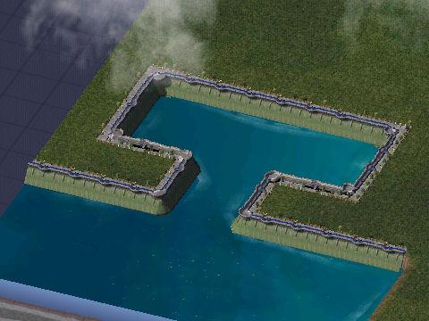
13 CREATING STRAIGHT EDGED COASTLINES Rochefort /14


14 And finally, if you have the imagination, lots of spare time and nothing else better to do, you can also go regional!!! CREATING STRAIGHT EDGED COASTLINES Rochefort /14
Introducing the Great Lakes
 Introducing the Great Lakes Just a few years ago, geologically speaking, a glacier passed this way, and that's why the Midwest has the Great Lakes. Size The Great Lakes and their connecting channels form
page - Laboratory Exercise #5 Shoreline Processes
 page - Laboratory Exercise #5 Shoreline Processes Section A Shoreline Processes: Overview of Waves The ocean s surface is influenced by three types of motion (waves, tides and surface currents). Shorelines
Build A Pool Window. Build a Pool Window. Step 1: Create a Basement
 Build A Pool Window This tutorial will show you, in basic steps, how to create windows looking into the swimming pool. Build a Pool Window Step 1: Create a Basement 1 P a g e If you know how to make a
HOW TO DIG A TEST PIT
 HOW TO DIG A TEST PIT An archaeological test pit is a small 1m by 1m trench dug in a series of layers, or spits, to a depth of approximately 1m. The archaeological materials collected from these layers
Finally Out of the Sand
 Finally Out of the Sand A Guide to Success in the Bunker Written By: Master Teaching Professional Adam Kolloff www.scratchgolfschool.com Introduction I can't tell you how many people roll their eyes when
Sounding Box Activity
 When done with Activity - Close this Window Sounding Box Activity Part 1: Making a Sounding Box: 1 box - shoe box or a small box from a grocery store Surprise sea floor items - You can use rocks, gravel,
Study of Passing Ship Effects along a Bank by Delft3D-FLOW and XBeach1
 Study of Passing Ship Effects along a Bank by Delft3D-FLOW and XBeach1 Minggui Zhou 1, Dano Roelvink 2,4, Henk Verheij 3,4 and Han Ligteringen 2,3 1 School of Naval Architecture, Ocean and Civil Engineering,
Death run 3d unblocked
 Мобильный портал WAP версия: wap.altmaster.ru Death run 3d unblocked Apr 13, 2018. 3D Death Run on Scratch by shoopdawhoop789.. Instructions. Arrow keys to look around in this awesome 3D world w to move
Earthworks X200 Quick Reference Guide
 Earthworks X200 Quick Reference Guide Part No. 875-0267-000 Rev. A1 Contents Dig a 1.0 m Deep Hole Using a Flat Plane 1 Extend a Level Excavation 3 Dig a 1.0 m Deep Hole Using a Flat Plane with a 5 Laser
Imagine that you can see a side view of a wave as it approaches a beach. Describe how the wave changes as the wave approaches the beach.
 Geology 101 Name Reading Guide for Ch. 19: Shores and Coastal Processes (p. 612) Waves, Currents, and Tides (p. 614) Waves and Currents (p. 614) Imagine that you can see a side view of a wave as it approaches
Sontek RiverSurveyor Test Plan Prepared by David S. Mueller, OSW February 20, 2004
 Sontek RiverSurveyor Test Plan Prepared by David S. Mueller, OSW February 20, 2004 INTRODUCTION Sontek/YSI has introduced new firmware and software for their RiverSurveyor product line. Firmware changes
Carving Horse Portraits in Relief: Patterns and Complete Instructions for 5 Horses. Click here if your download doesn"t start automatically
 Carving Horse Portraits in Relief: Patterns and Complete Instructions for 5 Horses Click here if your download doesn"t start automatically Carving Horse Portraits in Relief: Patterns and Complete Instructions
Dugout Sizing Worksheet. Joe Agricola Example
 Dugout Sizing Worksheet Joe Agricola Example This example is provided to help you size your farm dugout and determine if the runoff area selected will supply sufficient water. A blank copy of this worksheet
On Safari Dunedin Causeway, Dunedin Florida
 On Safari Dunedin Causeway, Dunedin Florida I ve been living in Florida for nearly two years and one of my favorite local locations is the Dunedin Causeway. Its easy, and its close and its productive.
1.5 How do ocean waves and currents change the face of coastal areas? (Chapter 3)
") 1.5 How do ocean waves and currents change the face of coastal areas? (Chapter 3) 1. Hydraulic Action/Pressure - air being forced into crack in rocks. 2. Corrosion (Solution) Minerals such as calcium carbonate
1.5 How do ocean waves and currents change the face of coastal areas? (Chapter 3) 1. Hydraulic Action/Pressure - air being forced into crack in rocks. 2. Corrosion (Solution) Minerals such as calcium carbonate
Frequently Asked Questions February 2015 SETUP
 Frequently Asked Questions February 2015 SETUP During game setup, how is the orientation of the submarine figures determined? Players must agree about the orientation of the submarine figures before the
GLIDING ON AIR (1 Hour)
") GLIDING ON AIR (1 Hour) Addresses NGSS Level of Difficulty: 4 Grade Range: 3-5 OVERVIEW In this activity, the students will construct a simple hovercraft. They will learn how friction helps or hinders
GLIDING ON AIR (1 Hour) Addresses NGSS Level of Difficulty: 4 Grade Range: 3-5 OVERVIEW In this activity, the students will construct a simple hovercraft. They will learn how friction helps or hinders
Fox Chapel Golf Club - Pittsburgh, PA
 INTERVIEW TRANSCRIPT: GREG NORMAN Wednesday, June 27, 2012 MARK WILLIAMS: Greg, thanks for joining us here in the media center at the Constellation SENIOR PLAYERS. It's good to have you back on the Champions
Darts CHAPTER 6. Next are seven sounds: snd_double_points snd_triple_points snd_take_cover snd_perfect snd_thud_1 snd_thud_2 snd_thud_3
 CHAPTER 6 In this chapter, you ll create a darts game. This game will continue to build upon what you have learned already. It will also show you more things you can do with paths, ds lists, custom fonts,
Page 1 GM-FAQ Club Profile FAQs. Page
 Page 1 Club Profile FAQs Page How do I see my club's profile?... 2 How do I update my club's profile?... 3 How do I add/change my club's picture?... 5 How do I add Social Media links to my club s profile?...
Cook Inlet pipeline crossing is about making the best choices
 Cook Inlet pipeline crossing is about making the best choices By Larry Persily lpersily@kpb.us Aug. 26, 2015 (This update, provided by the Kenai Peninsula Borough mayor s office, is part of an ongoing
Certified Professionals in Hydrographic Solutions
 Certified Professionals in Hydrographic Solutions Client Satisfaction is our Deliverable Port of Brisbane Pty Ltd Port Surveys Certified Professionals in Hydrographic Surveying Tel +61 (0) 7 3258 4820
Figure 1 GE image of the Costa Sur & EcoEléctrica power plants, located inside Guayanilla and Tallaboa bay.
 1 7 - STORM SURGES IN PUERTO RICO_Power Plants-Costa Sur & EcoElectrica Costa Sur & EcoEléctrica Figure 1 shows a GE image of the Costa Sur (Guayanilla) and EcoElectrica site. Figure 2 shows the topographic
FOR PERSONAL USE. Shoreline Erosion BROWARD COUNTY ELEMENTARY SCIENCE BENCHMARK PLAN ACTIVITY ASSESSMENT OPPORTUNITIES. Grade 4 Quarter 1 Activity 9
 activity 9 Shoreline Erosion BROWARD COUNTY ELEMENTARY SCIENCE BENCHMARK PLAN Grade 4 Quarter 1 Activity 9 SC.D.1.2.4 The student knows that the surface of the Earth is in a continuous state of change
Dobbin Day - User Guide
 Dobbin Day - User Guide Introduction Dobbin Day is an in running performance form analysis tool. A runner s in-running performance is solely based on the price difference between its BSP (Betfair Starting
Oceans in Motion: Waves and Tides
 Oceans in Motion: Waves and Tides Waves Waves are among the most familiar features in the ocean. All waves work similarly, so although we are talking about ocean waves here, the same information would
OECS Regional Engineering Workshop September 29 October 3, 2014
 B E A C H E S. M A R I N A S. D E S I G N. C O N S T R U C T I O N. OECS Regional Engineering Workshop September 29 October 3, 2014 Coastal Erosion and Sea Defense: Introduction to Coastal/Marine Structures
TITLE: COASTAL EROSION AND LANDFORMS.
 TITLE: COASTAL EROSION AND LANDFORMS. AIM: What are the factors that influence the formation of coastal features along Fishing Pond beach Trinidad? LOCATION OF FIELD STUDY: The study was carried out in
Homework 2 Bathymetric Charts [based on the Chauffe & Jefferies (2007)]
![Homework 2 Bathymetric Charts [based on the Chauffe & Jefferies (2007)]](/thumbs/75/72427079.jpg "Homework 2 Bathymetric Charts [based on the Chauffe & Jefferies (2007)]") 1 MAR 110 HW-2 - Bathy Charts Homework 2 Bathymetric Charts [based on the Chauffe & Jefferies (2007)] 2-1. BATHYMETRIC CHARTS Bathymetric charts are maps of a region of the ocean used primarily for navigation
1 MAR 110 HW-2 - Bathy Charts Homework 2 Bathymetric Charts [based on the Chauffe & Jefferies (2007)] 2-1. BATHYMETRIC CHARTS Bathymetric charts are maps of a region of the ocean used primarily for navigation
Directed Reading. Section: Ocean Currents. a(n). FACTORS THAT AFFECT SURFACE CURRENTS
. FACTORS THAT AFFECT SURFACE CURRENTS") Skills Worksheet Directed Reading Section: Ocean Currents 1. A horizontal movement of water in a well-defined pattern is called a(n). 2. What are two ways that oceanographers identify ocean currents? 3.
Skills Worksheet Directed Reading Section: Ocean Currents 1. A horizontal movement of water in a well-defined pattern is called a(n). 2. What are two ways that oceanographers identify ocean currents? 3.
Artificial headlands for coastal restoration
 Artificial headlands for coastal restoration J. S. Mani Professor, Department of Ocean Engineering, Indian Institute of Technology Madras, Chennai 636, India Abstract Construction of a satellite harbour
from the PSIA Nordic Team February, 2014
 news from the PSIA Nordic Team February, 2014 d Nord News d Nord is a fabrication of the PSIA Nordic Team. Divisions are welcome to reprint partial or complete articles from here at will (with credit)
10.6 The Dynamics of Drainage Flows Developed on a Low Angle Slope in a Large Valley Sharon Zhong 1 and C. David Whiteman 2
 10.6 The Dynamics of Drainage Flows Developed on a Low Angle Slope in a Large Valley Sharon Zhong 1 and C. David Whiteman 2 1Department of Geosciences, University of Houston, Houston, TX 2Pacific Northwest
Tsunami Preparedness in the Capital Region
 Tsunami Preparedness in the Capital Region A presentation by: the CRD Local Government Emergency Program Advisory Commission (LG EPAC) and your community emergency programs What is a tsunami? A tsunami
An in-depth look at Church Tackles Stern Planer
 An in-depth look at Church Tackles Stern Planer By: Steve Becker The pressure was on to catch some fish, I was fishing with people that had high expectations. They had heard stories of me recently catching
Counterbore and Countersink Tutorial
 Counterbore and Countersink Tutorial This tutorial is designed to show how to create a Counterbore hole in two different ways. 1. Creating 2 Extrudes 2. Using the Hole Tool Types of Holes Counterbore Holes
Techniques for Deeper Diving
 Techniques for Deeper Diving Deeper diving is usually defined as dives deeper than 60 feet. These dives must take into consideration better use of many diving skills that we might take for granted on shallower
SORTING AND SELECTIVE MOVEMENT OF SEDIMENT ON COAST WITH STEEP SLOPE- MASUREMENTS AND PREDICTION
 SORTING AND SELECTIVE MOVEMENT OF SEDIMENT ON COAST WITH STEEP SLOPE- MASUREMENTS AND PREDICTION Toshiro San-nami 1, Takaaki Uda 2, Masumi Serizawa 1 and Toshinori Ishikawa 2 Conveyer belts carrying gravel
Friction. Experiment 1 A Soleful Experiment
 Friction Now let s talk about the other ever present force on this Earth, and that s friction. Friction is the force between one object rubbing against another object. Friction is what makes things slow
User Guide Addendum Course and Feature Expansion Package. Overview of Changes
 User Guide Addendum Course and Feature Expansion Package Version 3 of the SkyCaddie software (also known as the Course and Feature Expansion Package) includes the following features: IntelliGreen Pro (Beta)
The Sea Geography Notes JC-Learn. JC-Learn. Geography Notes The Sea. 1 P a g e
 JC-Learn Geography Notes The Sea 1 P a g e The Sea *Here, you can choose to study the chapter on glaciation or the one on the sea, or even both, because whenever these topics come up in the Junior Cert
The Complete 5 Step Pass Game In The Pistol. By: James Vint
 The Complete 5 Step Pass Game In The Pistol By: James Vint coachvint@gmail.com Base Protection Concepts Big On Big Slide Protection Turnback Protection Zone Schemes Man/Zone Schemes 5 Man Protection 6
UNDERSTANDING STORM SURGE
 The Education Program at the New Jersey Sea Grant Consortium 22 Magruder Road, Fort Hancock, NJ 07732 (732) 872-1300 www.njseagrant.org UNDERSTANDING STORM SURGE ACTIVITY 6 SURGE OF THE STORM http://secoora.org/classroom/virtual_hurricane/surge_of_the_storm>
Deep-water orbital waves
 What happens when waves approach shore? Deep-water orbital waves Fig. 9.16, p. 211 Wave motion is influenced by water depth and shape of the shoreline wave buildup zone surf zone beach Wave base deepwater
OLCG Supplementary Unit on Snow Snow Pits Lesson Plan
 OLCG Supplementary Unit on Snow Snow Pits Lesson Plan Topic: Target Level: Snow 4th grade Performance Standards: Alaska Science A2-Level 2 - Students observe physical and chemical properties of common
CONFORMATION RECORDING OF DAIRY CATTLE
 International Committee for Animal Recording CONFORMATION RECORDING OF DAIRY CATTLE The ICAR multi dairy breed conformation recording recommendation integrates with the World Holstein-Friesian Federation
With a better idea of the space I had to deal with, I decided to make a regulator mock up to experiment on before risking the life of another reg, a
 The Dacor Olympic 400 and 800 series of regulators were sold for a good number of years but in the modern era do not have any following for a multitude of reasons. They are fairly large, heavy and parts
4/20/17. #32 - Coastal Erosion Case Histories - Lake Michigan
 Writing Assignment Due Monday by 11:59 pm #32 - Coastal Erosion Case Histories - Lake Michigan See main class web pages for detailed instructions Submit papers Illinois Compass No copying: Compass will
Tommy Armour III.txt 1
 1 FEBRUARY 14, 2010 INTERVIEW WITH TOMMY ARMOUR, III Q. Well, Tommy, thanks for joining us. I guess couldn't do much more out there than throw a 61 up there. TOMMY ARMOUR, III: I don't know. Q. Finish
Belays on snow. by Gottlieb Braun-Elwert
 Belays on snow by Gottlieb Braun-Elwert Snow stakes are a Kiwi invention and have been around since the early 1970s. It is a piece of aluminium alloy profile with a tape attached to the top end. Mostly
Planning and general precautions ithrust Tunnel Systems installations.
 Version 1.0 This recommendation will go through the different factors to consider when choosing where and how to fit thruster tunnels in a boat. Some of these recommendations might be difficult, or even
Push Button Minute Timer Programmable between 1 minute and 30 minutes with built in multi-way control
 Setup Functions Guide MMTM/PB Push Button Minute Timer Programmable between 1 minute and 30 minutes with built in multi-way control DIGINET.NET.AU Timer Setup Push Button Minute Timer The LEDsmart + push
3 Star Touring Canoe Assessment Notes
 3 Star Touring Canoe Assessment Notes Technical Syllabus The 3 Star paddler can consider themselves as an intermediate paddler rather than a beginner; they have demonstrated personal competence as a member
Concepts & Phenomena
 Concepts & Phenomena in coastal and port sedimentation R. Kamalian Ports and Maritime Organization of Iran and PIANC-Iran 7 9 December 2015 What is the problem? Many harbours have sedimentation problems
Dry Hydrants. The installation of a non-pressurized pipe system into local water sources provides a ready means of supplying water to fire engines.
 Dry Hydrants What is a Dry Hydrant? A dry hydrant is a non-pressurized pipe system permanently installed in existing lakes, ponds and streams that provides a suction supply of water to a fire department
Label the diagram below with long fetch and short fetch:
 Coastal Processes Coasts are shaped by the sea and the action of waves. The processes that take place are erosion, transportation and deposition. The power of waves is one of the most significant forces
Technical Note AN EMPIRICAL. METHOD FOR DESIGN OF BREAKWATERS AS SHORE PROTECTION STRUCTURES
 CETN III-23 (Rev 3/95) Coastal Engineering Technical Note AN EMPIRICAL. METHOD FOR DESIGN OF BREAKWATERS AS SHORE PROTECTION STRUCTURES PURPOSE: To present an empirical method that can be used for preliminary
THE HAFENSKIPPER Dock & Maneuver in the Harbor
 DER HAFENSKIPPER Anlegen & Manövrieren im Hafen THE HAFENSKIPPER Dock & Maneuver in the Harbor DER HAFENSKIPPER Information and Manual for the Hafenskipper-App 2015 STUR UG (haftungsbeschränkt) STUR UG
Level 2 Physics, 2017
 91170 911700 2SUPERVISOR S Level 2 Physics, 2017 91170 Demonstrate understanding of waves 2.00 p.m. Friday 10 November 2017 Credits: Four Achievement Achievement with Merit Achievement with Excellence
Tsunami Preparedness in the Capital Region
 Tsunami Preparedness in the Capital Region A presentation by: the CRD Local Government Emergency Program Advisory Commission (LG EPAC) and your community emergency programs What is a tsunami? A tsunami
BOX RUN MARKER CONE DRILLS
 1 BOX RUN Box drills are an excellent activity to improve agility and body control. Lay out the cones as per image. Line up group behind the start cone. Groups of 6-8 are ideal for each box pattern. General
Narrows West. Lots For Sale Overview
 Lots For Sale Overview Spring/Summer Sales Book 2017 My family has been living at the Lake Manitoba Narrows for approximately 100 years. One of my grandfathers settled on the west shore of the Narrows
Moments and Pressure Workshop
 Moments and Pressure Workshop This workshop will cover the following: a. Moments b. Moment units (Nm) c. Anticlockwise moment = Clockwise moment d. Pressure e. Pressure in liquids Moments A moment is the
GNX 20/21. Owner s Manual
 GNX 20/21 Owner s Manual Table of Contents Introduction...1 Device Overview... 1 Using the Race Timer... 1 Profiles... 1 Selecting a Profile... 1 Restoring Profiles to their Default Settings... 1 Instrument
Sometimes 35 is faster than 60 Signals and Speed Considerations
 Sometimes 35 is faster than 60 Signals and Speed Considerations One of the things you ll want to think about in designing your route is track speed and the effect signaling can have on it. Another factor
Rocky River Golf Club
 The tee shot for this straightaway Par 4 must avoid trees on both sides to set up a short to mid-iron approach. A bunker guards the left side of a threetiered green. Tee Shots should stay to the right
Lesson 46: Properties of Waves
 Lesson 46: Properties of Waves Illustration 1: Is that Mr.C??? When you hear the word waves you probably have visions of hanging ten off of Waikiki. Although these are waves, we will be looking at a more
VIDEO TRANSCRIPT. A Proposal to Expand the Flower Garden Banks National Marine Sanctuary An interview with Sanctuary Superintendent, G.P.
 VIDEO TRANSCRIPT A Proposal to Expand the Flower Garden Banks National Marine Sanctuary An interview with Sanctuary Superintendent, G.P. Schmahl (Opening scene of Flower Garden Banks National Marine Sanctuary
Chapter 5 Decompression, Dive Tables, and Dive Computers
 Chapter 5 Decompression, Dive Tables, and Dive Computers Nitrogen and Diving 1. If the partial pressure of nitrogen in the air you are breathing is greater than the pressure of nitrogen in your body, your
BEACH NOURISHMENT BY RAINBOWING FOR THE VISAKHAPATNAM PORT TRUST BY DCI. Capt. MVR MURTHY ABSTRACT
 BEACH NOURISHMENT BY RAINBOWING FOR THE VISAKHAPATNAM PORT TRUST BY DCI Capt. MVR MURTHY ABSTRACT The coastal city of Visakhapatnam had a long wide beach. Over past three decades, this beach has progressively
FUCILI GUNS FUSILS FUSILES
 FUCILI GUNS FUSILS FUSILES 6 User's manual for Cressi-sub Comanche spearguns Congratulations! The product you purchased is the result of continuous research and development carried out by our technical
A New Generator for Tsunami Wave Generation
 Journal of Energy and Power Engineering 10 (2016) 166-172 doi: 10.17265/1934-8975/2016.03.004 D DAVID PUBLISHING Tetsuya Hiraishi 1, Ryokei Azuma 1, Nobuhito Mori 2, Toshihiro Yasuda 2 and Hajime Mase
Dive Planet. Manual. Rev Basic User Interface. 2 How to organize your dives. 3 Statistics. 4 Location Service and Map View.
 Dive Planet Manual Rev 1.2 1 Basic User Interface 2 How to organize your dives 3 Statistics 4 Location Service and Map View 5 Settings 6 Languages 7 Buddies and guide 8 Backup and restore of the data 9
Beaches Unit (4.5 pts)
") T. James Noyes, El Camino College Beaches Unit (Topic 6A) page 1 Name: Section: Beaches Unit (4.5 pts) Beaches and Shorelines Are Always Changing Waves are slowly and inexorably altering the shoreline,
T. James Noyes, El Camino College Beaches Unit (Topic 6A) page 1 Name: Section: Beaches Unit (4.5 pts) Beaches and Shorelines Are Always Changing Waves are slowly and inexorably altering the shoreline,
RESPIRATORY MOTION IN RADIATION THERAPY
 RESPIRATORY MOTION IN RADIATION THERAPY Significant effect on targets in the chest and upper abdominal cavities Can cause difficulty in reproducing radiation planning protocols in radiation treatment sessions
The Storm Surge Hazard 2018 TS-8 Tropical Meteorology 2
 The Storm Surge Hazard 2018 TS-8 Tropical Meteorology 2 Daniel Noah National Weather Service Tampa Bay daniel.noah@noaa.gov Tropical Cyclone Storm Surge Is a large dome of water, often 50 to 100 miles
Homework 2a Bathymetric Charts [based on the Chauffe & Jefferies (2007)]
![Homework 2a Bathymetric Charts [based on the Chauffe & Jefferies (2007)]](/thumbs/73/69074241.jpg "Homework 2a Bathymetric Charts [based on the Chauffe & Jefferies (2007)]") 14 August 2008 MAR 110 HW-2a: ex1bathymetric Charts 1 2-1. BATHYMETRIC CHARTS Homework 2a Bathymetric Charts [based on the Chauffe & Jefferies (2007)] Nautical charts are maps of a region of the ocean
14 August 2008 MAR 110 HW-2a: ex1bathymetric Charts 1 2-1. BATHYMETRIC CHARTS Homework 2a Bathymetric Charts [based on the Chauffe & Jefferies (2007)] Nautical charts are maps of a region of the ocean
What is an ocean current? 1. wind action: the force of the wind blowing over the top of the water 2. spin of Earth 3. shape of the continents
 Ocean Currents Textbook pages 414 427 Before You Read Section 11.2 Summary What forces do you think cause ocean water to move? Do you think ocean water moves the same way everywhere in the ocean? Write
Ocean Currents Unit (4 pts)
") Name: Section: Ocean Currents Unit (Topic 9A-1) page 1 Ocean Currents Unit (4 pts) Ocean Currents An ocean current is like a river in the ocean: water is flowing traveling from place to place. Historically,
Name: Section: Ocean Currents Unit (Topic 9A-1) page 1 Ocean Currents Unit (4 pts) Ocean Currents An ocean current is like a river in the ocean: water is flowing traveling from place to place. Historically,
v2.3 USER MANUAL
 v2.3 USER MANUAL www.foresightsports.com Table of Contents 03 04 05 09 12 17 20 21 Activation Getting Started Play Compete Improve Settings Update Manager Glossary 04 11 05 12 03 Activation FSX Activation
11 Short Game Drills To Help You Up And Down It From Anywhere!
 Table of Contents Introduction... 3 Chipping... 4 Drill #1 - Wrist Firm (Part 1)... 4 Drill #2 - Wrist Firm (Part 2)... 4 Drill #3 - Chipping Accuracy... 6 Pitching... 8 Drill #1 - Distance Control (Part
Wiimote Visualization Through Particles
 1 Abstract Wiimote Visualization Through Particles Joshua Jacobson Since 2006, the Wii video game console has been found within homes throughout out the world. The Wiimote exists as the primary input method
MAKE & COLLABORATE: BOWLING WITH OZOBOT
 MAKE & COLLABORATE: BOWLING WITH OZOBOT To try this project, you will need an Ozobot Bowling with Ozobot This bowling game is an example of how to use Ozobot in connection with a game piece to create fun
NACA Submerged Duct Construction By Bill Whitehouse Glastar builder
 NACA Submerged Duct Construction By Bill Whitehouse Glastar builder We have all seen the submerged ramp V shaped air ducts on our airplanes. Almost any hole of that general shape is referred to as a NACA
Engineering Design Challenge. Mapping the Ocean Floor
 Engineering Design Challenge Project Title: Project Source: Project Submitter: Mapping the Ocean Floor NOAA, http://tinyurl.com/boydlek STEM Improvement Lesson Development Team Grade Level/Subject: Math,
Sail Chart Drafter for Deckman v.2
 Sailing Performer present Sail Chart Drafter for Deckman v.2 This application has been made to help navigators and trimmers to find the right sail to use in a faster and easier way than ever. Sail Chart
from ocean to cloud HEAVY DUTY PLOUGH PERFORMANCE IN VERY SOFT COHESIVE SEDIMENTS
 HEAVY DUTY PLOUGH PERFORMANCE IN VERY SOFT COHESIVE SEDIMENTS Geoff Holland, Sarah Dzinbal (Alcatel-Lucent Submarine Networks) Email: geoff.holland@alcatel-lucent.com Alcatel-Lucent Submarine Networks
Level 1 Science, 2012
 90940 909400 1SUPERVISOR S Level 1 Science, 2012 90940 Demonstrate understanding of aspects of mechanics 9.30 am Monday 19 November 2012 Credits: Four Achievement Achievement with Merit Achievement with
Sometimes it isn t best to get your boules close to the cochonnet
 Sometimes it isn t best to get your boules close to the cochonnet If your opponents have a good shooter, your boule will usually get shot out. With a strong team of good shooters (if they're holding the
Quarterly report of the marine Safety Management System (SMS) performance and incident statistics April Q1 2019
 performance and incident statistics April Q1 2019") Quarterly report of the marine Safety Management System (SMS) performance and incident statistics April 9 - Q 9 Serious and very serious incidents There has been serious incident so far in 9 which is below
Quarterly report of the marine Safety Management System (SMS) performance and incident statistics April 9 - Q 9 Serious and very serious incidents There has been serious incident so far in 9 which is below
Creating Coastal Lots
 Introduction This short and simple tutorial will guide us through creating coastal lots building sites that are placed by the sea in a hood that has sea. In such a coastal lot, we can build complex harbours
The ocean water is dynamic. Its physical
 CHAPTER MOVEMENTS OF OCEAN WATER The ocean water is dynamic. Its physical characteristics like temperature, salinity, density and the external forces like of the sun, moon and the winds influence the movement
GOLF COURSES. The Concierge Team Marriott s Marbella Beach Resort
 GOLF COURSES The Costa del Sol is famous for its fantastic golf courses, and our Owners and guests receive special rates at many of them. Whether you re a novice in search of a friendly course or a seasoned
NYS Coastal Waters. Water Resources of NYS: THE NATURE of the COASTAL ZONE. NYS Coastal Waters. NYS Coastal Atlas. Coastal Zone Management 10/10/2014
 Water Resources of NYS: THE NATURE of the COASTAL ZONE NYS Coastal Waters NYS is the only state to border the Atlantic Ocean and the Great Lakes (Lakes Erie and Ontario). Great Lakes shoreline: 577 miles
Exemplar for Internal Assessment Resource Geography Level 3. Resource title: The Coastal Environment Kaikoura
 Exemplar for internal assessment resource Geography 3.5A for Achievement Standard 91430 Exemplar for Internal Assessment Resource Geography Level 3 Resource title: The Coastal Environment Kaikoura This
Breakwaters and closure dams CT 5308 Exercise 2011: Pointe Noire, Congo
 Breakwaters and closure dams CT 5308 Exercise 2011: Pointe Noire, Congo The town of Pointe Noire is the main port city in the Republic of the Congo and sits on the south-western African coast some 150
From and
 From http://www.school-for-champions.com/science/fluidpressure.htm and http://www.school-forchampions.com/science/fluidfloating.htm by Ron Kurtus, School for Champions Pressure in Fluids by Ron Kurtus
Coaching Players Ages 17 to Adult
 Coaching Players Ages 17 to Adult This section provides you with a twelve-week training program for players ages 17 through Adult. Each practice features four fun and progressive drills and culminates
Robotic Pool Cleaners
 Robotic Pool Cleaners Relax and Enjoy Your Pool Dolphin robotic pool cleaners by Maytronics deliver automated, high-performance pool cleaning - efficiently and effectively. Building on decades of expertise