Introducing the Great Lakes
|
|
|
- Quentin Barnett
- 6 years ago
- Views:
Transcription


1 Introducing the Great Lakes Just a few years ago, geologically speaking, a glacier passed this way, and that's why the Midwest has the Great Lakes. Size The Great Lakes and their connecting channels form the largest fresh surface water system on Earth. Visible from the moon 1

2 The Great Lakes: Size Cover more than 94,000 square miles and drain more than twice as much land. Hold an estimated 6 quadrillion gallons of water, about one-fifth of the world's fresh surface water supply and nine-tenths of the U.S. supply. Size Spread evenly across the contiguous 48 states, the lakes' water would be about 9.5 feet deep. All five of the Great Lakes are among the world's 18 largest lakes by area and volume. The Great Lakes and islands within them have more than 10,000 miles of coastline. 2

3 Age One of the youngest natural features on the North American continent. 10ky 3
4 The Great Lakes Watershed The Great Lakes watershed includes part or all of eight U.S. states (Minnesota, Wisconsin, Illinois, Indiana, Michigan, Ohio, Pennsylvania an Ndew York) and the Canadian province of Ontario. Today, more than 33 million people inhabit this drainage basin: more than one-tenth of the population of the United States and one-quarter of the population of Canada. Lake Superior is the largest of the Great Lakes in surface area and volume. L. Superior has the largest surface area of any freshwater lake in the world. The lake stretches 350 miles from west to east and 160 miles north to south. Its shoreline is nearly 2,800 miles long. L. Superior is also the coldest and deepest of five Great Lakes. Average depths are close to 500 feet; the deepest point in the lake reaches 1,332 feet. the 4

5 Lake Michigan is the second largest of the Great Lakes by volume The only Great Lake entirely within the United States. Averages 279 feet deep Reaches 925 feet at its deepest point L. Michigan is approximately 118 miles wide and 307 miles long and boasts more than 1,600 miles of shoreline, including many sandy beaches. The world's largest freshwater sand dunes line the shores of Lake Michigan. Lake Huron is the third largest of the Great Lakes by volume The shores of Huron extend more than 3,800 miles the longest shoreline of the Great Lakes, counting the shorelines of its 30,000 islands. Manitoulin Island in Lake Huron is the largest freshwater island in the world. characterized by shallow, sandy beaches and the rocky coasts of Georgian Bay. L. Huron is 206 miles wide and approximately 183 miles from north to south. Lake Huron averages a depth of 195 feet and is home to many ship wrecks,. Hydrologically speaking, Lakes Michigan and Huron are actually "one" Great Lake, separated by the Straits of Mackinaw. The 5 miles long Mackinac Bridge spans the straits, connecting Michigan's upper and lower peninsulas. 5


6 Lake Erie is the shallowest of the Great Lakes (averaging only 62 feet) and overall the smallest by volume. L. Erie is also exposed to the greatest effects from urbanization and agriculture. L. Erie measures 241 miles wide and 57 miles from north to south, and has 871 miles of shoreline. Because it's not as deep as the other lakes, Erie warms rapidly in the spring and summer, and is frequently the only Great Lake to freeze over in winter. Lake Erie is the warmest and most biologically productive of the Great Lakes. The Lake Erie walleye fishery is widely considered the best in the world. 6

 below Lake Erie, at the base of Niagara Falls.")
7 Lake Ontario is similar to Lake Erie in surface area and physical dimensions, but is a much deeper lake, averaging 283 feet. Lake Ontario holds almost four times more water than Lake Erie. L. Ontario ranks fourth among the Great Lakes in maximum depth, but its average depth is second only to Lake Superior. Lake Ontario lies 325 ft (99 m) below Lake Erie, at the base of Niagara Falls. Niagara Falls were always an obstacle to navigation into the upper lakes until the Trent-Severn Waterway, along with the Welland and Erie canals were built to allow ships to pass around this bottleneck. 7


8 Assignment for Wednesday Look up the history of the Great Lakes or the United States Find out the name of the explorer or missionary to first see each of the Great Lakes. Name the person s country of origin. Indicate the year of the discovery. Must be typed Must cite resources utilized 8
Adapting to Climate Change In Coastal Environments
 Adapting to Climate Change In Coastal Environments Peter Nimmrichter, P.Eng. AMEC Earth and Environmental, Mississauga, Ontario 19/11/2007 1 The Great Lakes Watershed The Great Lakes cover an area of 244,160
National Maritime Center
 National Maritime Center Providing Credentials to Mariners (Sample Examination) Page 1 of 8 Choose the best answer to the following Multiple Choice Questions. 1. Assume that your vessel has just entered
NYS Coastal Waters. Water Resources of NYS: THE NATURE of the COASTAL ZONE. NYS Coastal Waters. NYS Coastal Atlas. Coastal Zone Management 10/10/2014
 Water Resources of NYS: THE NATURE of the COASTAL ZONE NYS Coastal Waters NYS is the only state to border the Atlantic Ocean and the Great Lakes (Lakes Erie and Ontario). Great Lakes shoreline: 577 miles
SCIENCE AND TECHNOLOGY: CANADA COAST TO COAST
 ACTIVITY DESCRIPTION: This activity shows the abundance of water in and around Canada. By identifying and labeling a number of water bodies and courses, students realize the magnitude of Canada s water
The Chesapeake Bay as an Estuary: An introduction. Istvan A. Urcuyo Gettysburg College
 The Chesapeake Bay as an Estuary: An introduction. Istvan A. Urcuyo Gettysburg College The Chesapeake Bay -Native Americans resided on its shores since 8000 B.C. The Chesapeake Bay -Original Native American
Great Lakes Commission Semiannual Meeting
 Great Lakes Commission Semiannual Meeting Great Lakes Water Levels Forecasts March 6, 2013 Washington D.C. Keith Kompoltowicz Chief, Watershed Hydrology Detroit District Corps of Engineers Recent Analysis/Forecast
A Brief Introduction to the Great Lakes. Geographical History. Lake Ontario. Lake Erie
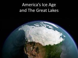
 A Brief Introduction to the Great Lakes Geographical History The Great Lakes were formed during the last ice age, roughly 10,000 years ago The Glaciers carved the lakes out of an existing basin, and when
Seasonal Summary. For The Great Lakes. Winter
 Seasonal Summary For The Great Lakes Winter 2007-2008 Produced by the North American Ice Service August 2008 Table of Contents General General overview of the past season...4 Lake Superior...9 Lake Michigan
Crabtree Publishing Company
 By Lynn Peppas Company www.crabtreebooks.com Author: Lynn Peppas Editor: Barbara Bakowski Designer: Tammy West, Westgraphix LLC Photo Researcher: Edward A. Thomas Map Illustrator: Stefan Chabluk Indexer:
More Than Just a Lake!
 By creating a map of the rivers flowing into your Great Lake, learn how rivers form a watershed. TOPIC Great Lake drainage basins AUDIENCE Grades 1-6; 10-30 students SETTING Large, open indoor space is
STUDY PERFORMANCE REPORT
 STUDY PERFORMANCE REPORT State: Michigan Study No.: 427 Project No.: F-81-R-1 Title: Measurement of sportfishing harvest in lakes Michigan, Huron, Erie, and Superior Period Covered: October 1, 1999 to
SCIENCE AND TECHNOLOGY: TAPS AND DRAINS
 ACTIVITY DESCRIPTION: This activity is designed to test the students knowledge of water trivia in a fun, interactive environment. Students will play a game, similar to snakes and ladders. Depending on
Physical Features, Where People Live, & How They Trade
 Physical Features, Where People Live, & How They Trade 5 large freshwater lakes in central North America HOMES (Huron, Ontario, Michigan, Erie, Superior) Serve as the industrial heartland of the continent
Parts and Pieces The Story of Chicago and Lake Michigan
 Parts and Pieces The Story of Chicago and Lake Michigan You may draw pictures to show what each part of this history might have looked like. Draw your pictures next to the words. You also may cut these
Rivers Of Sand: Fly Fishing Michigan And The Great Lakes Region By Josh Greenberg READ ONLINE
 Rivers Of Sand: Fly Fishing Michigan And The Great Lakes Region By Josh Greenberg READ ONLINE Abstract: Brook trout are native to Lake Michigan and many of its where juvenile fish leave Great Lakes tributaries
Gayaza High School Geography Department
 THE DEVELOPMENT OF THE SAINT LAWRENCE SEAWAY This is an inland water way partly artificially constructed from the Gulf of St. Lawrence to the Western end of Lake Superior. It covers a distance of 3,800
STUDY PERFORMANCE REPORT
 STUDY PERFORMANCE REPORT State: Michigan Study No.: 427 Project No.: F-81-R-2 Title: Measurement of sportfishing harvest in lakes Michigan, Huron, Erie, and Superior Period Covered: October 1, 2000 to
Jessica Grimm Ed Tillett Kim Russo
 Webinar Hosts Jessica Grimm, Sailing Specialist with Navionics, has been sailing and boating for most of her life. She and her husband spent a year in the Bahamas and Caribbean living on their sailboat
1.5 How do ocean waves and currents change the face of coastal areas? (Chapter 3)
") 1.5 How do ocean waves and currents change the face of coastal areas? (Chapter 3) 1. Hydraulic Action/Pressure - air being forced into crack in rocks. 2. Corrosion (Solution) Minerals such as calcium carbonate
1.5 How do ocean waves and currents change the face of coastal areas? (Chapter 3) 1. Hydraulic Action/Pressure - air being forced into crack in rocks. 2. Corrosion (Solution) Minerals such as calcium carbonate
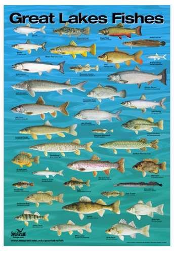
Geology. Key Factors. Overfishing. Great Lakes Fishes. Historical Fishing. About 10,000 years since last glacial retreat very young ecologically
 Great Lakes Fishes Geology About 10,000 years since last glacial retreat very young ecologically Largest surface freshwater system on earth 21% of world s supply 84% of North America s supply Five unique
Great Lakes Shipping Across The Country & Around The World Great Lakes Floor Map: Shipping and Receiving Cargo on the Great Lakes
 Lesson #1 Lesson #2 Great Lakes Shipping Across The Country & Around The World Great Lakes Floor Map: Shipping and Receiving Cargo on the Great Lakes Laura Mikesell Laura.Mikesell@gpschools.org Parcells
Montessori for Everyone 2013 Types of Coastlines
 Coast The coast is the part of the land that borders the sea. It is subject to constant change, as the result of the waves and deposits carried by water onto the land. Coastline The coastline is where
In each summer issue of Lake
 The 2000 Lake Erie Walleye Report by Rick Kubb In each summer issue of Lake Erie Walleye Magazine, we provide a synopsis of the walleye fishery in Lake Erie based on the scientific reports produced by
Michigan. Sample file. Content Adviser: Roger Rosentreter, Michigan Historical Society, Lansing, Michigan
 t h i s l a n d i s y o u r l a n d Michigan b y a n n h e i n r i c h s Content Adviser: Roger Rosentreter, Michigan Historical Society, Lansing, Michigan Reading Adviser: Dr. Linda D. Labbo, Department
Barrier fact sheet. For more info see:
 Barrier fact sheet Barrier Fact Sheet These are the current types of barriers that are being used in the Great s. They attempt to keep sea lampreys from migrating upstream to their spawning grounds. for
The St. Lawrence Seaway--To Mid-Continent by Ocean Vessel
 Case Western Reserve Law Review Volume 11 Issue 1 1959 The St. Lawrence Seaway--To Mid-Continent by Ocean Vessel Lewis W. Britton Follow this and additional works at: http://scholarlycommons.law.case.edu/caselrev
Laurentian Great Lakes and their invasive species. Jeff Gunderson Minnesota Sea Grant College Program
 Laurentian Great Lakes and their invasive species Jeff Gunderson Minnesota Sea Grant College Program Largest Group of Freshwater Lakes in the World Contain 21% of the worlds surface freshwater Variety
Apostle Islands National Seashore
 Apostle Islands National Seashore David Speer & Phillip Larson October 2 nd Fieldtrip Report Table of Contents Introduction 1 Stop 1: Apostle Island Boat Cruise 1 Stop 2: Coastal Geomorphology 5 Stop 3:
OCEANOGRAPHY STUDY GUIDE
 OCEANOGRAPHY STUDY GUIDE Chapter 2 Section 1 1. Most abundant salt in ocean. Sodium chloride; NaCl 2. Amount of Earth covered by Water 71% 3. Four oceans: What are they? Atlantic, Pacific, Arctic, Indian
During the mid-to-late 1980s
 The 2001 Yellow Perch Report by Rick Kubb During the mid-to-late 1980s the yellow perch popula tions in Lake Erie were among the highest on record. Limit catches by fishermen were extremely common during
The GREAT Lakes. Vocabulary Elevation: the geographic height (ie. The height of the lake surface in relation to the height of the ocean)
") The GREAT Lakes Activity Overview In this activity, students will look at the size of the Great Lakes with respect to the earth. They will see how volume compares to surface area. They will also look at
The GREAT Lakes Activity Overview In this activity, students will look at the size of the Great Lakes with respect to the earth. They will see how volume compares to surface area. They will also look at
CREATING STRAIGHT EDGED COASTLINES, CANALS & PORTS
 CREATING STRAIGHT EDGED COASTLINES, CANALS & PORTS Important note: This method can ONLY be used prior to development taking place. If you attempt to raise or lower land levels during an existing game you
What was the historic coaster fishery like?
 1 of 6 1/30/2012 12:25 PM Home About Topics Contact Us Fishing Calendar Fish ID Tips FAQs Hack Noyes Research Vessel Is it a unique strain long lost from Wisconsin's shoreline? Fisheries Reports Tributaries
Marine Environments. Copyright 2011 LessonSnips
 Marine Environments I must go down to the seas again, for the call of the running tide Is a wild call and a clear call that may not be denied Excerpt from a poem by John Masefield Continents and islands
Environmental. Effects of Dredging
 Envi~onmental Effects of Dredging Technical Notes THE VALUE OF GRAVEL DISPOSAL MOUNDS IN RIVER SIDE CHANNELS FOR FRESHWATER MUSSELS PURPOSE: This note provides information on the value of gravel disposal
Total Phosphorus Loading to the Great Lakes
 Total Phosphorus Loading to the Great Lakes Dave Dolan, Natural & Applied Sciences, University of Wisconsin - Green Bay Pete Richards,, - Tiffin, Ohio Kevin McGunagle Farmington Hills, Michigan Objectives
Earth s oceans covers 71 % _ of the planet s surface. In reality, Earth s ocean waters are all. interconnected as part of a single large global ocean.
 Ocean Motion Met 101: Introduction to the World's Oceans Produced by The COMET Program Geography: Name Pd. Earth s oceans covers 71 % _ of the planet s surface. In reality, Earth s ocean waters are all
May 17, Dear Senator:
 Alaska Clean Water Advocacy * Alliance for the Great Lakes *Altamaha Riverkeeper * American Rivers *Bad River Watershed Association * BaySail * Black Warrior Riverkeeper * California Sportfishing Protection
Answers to Ontario Quiz
 Answers to Ontario Quiz Test Your Knowledge What do you remember from your review of the Ontario section of the E-Atlas? 1. Ontario is one of the biggest contributors to Canada s gross domestic product
What DNA tells us about Walleye (& other fish) in the Great Lakes
 in the Great Lakes") What DNA tells us about Walleye (& other fish) in the Great Lakes Carol Stepien, Douglas Murphy, Rachel Lohner, & Jo Ann Banda Great Lakes Genetics Lab Lake Erie Center University of Toledo What do we
What DNA tells us about Walleye (& other fish) in the Great Lakes Carol Stepien, Douglas Murphy, Rachel Lohner, & Jo Ann Banda Great Lakes Genetics Lab Lake Erie Center University of Toledo What do we
Adapting and Developing Hands Free Mooring for Navigation Locks Speaker: Benoit Nolet
 Adapting and Developing Hands Free Mooring for Navigation Locks Speaker: Benoit Nolet The Great Lakes St. Lawrence Seaway System A gateway to the heartland of North America 3,700 km (2,300 m) marine highway
AMERIGO VESPUCCI ( )
") AMERIGO VESPUCCI (1451-1512) Amerigo Vespucci was born in Italy in 1451. Vespucci went on several expeditions to South America. In 1501, he sailed in service to the King of Portugal. This was his third
AMERIGO VESPUCCI (1451-1512) Amerigo Vespucci was born in Italy in 1451. Vespucci went on several expeditions to South America. In 1501, he sailed in service to the King of Portugal. This was his third
Why do different beaches have different types of vegetation?
 Why do different beaches have different types of vegetation? Allan Crowe Environment Canada National Water Research Institute Burlington, Ontario Environment Canada Environnement Canada NATIONAL WATER
4/20/17. #32 - Coastal Erosion Case Histories - Lake Michigan
 Writing Assignment Due Monday by 11:59 pm #32 - Coastal Erosion Case Histories - Lake Michigan See main class web pages for detailed instructions Submit papers Illinois Compass No copying: Compass will
OCN 201 Tides. Tsunamis, Tides and other long waves
 OCN 201 Tides Tsunamis, Tides and other long waves Storm surges Caused by winds and low atmospheric pressure associated with large storms Can raise sea surface by up to 25 ft, bottom contours magnify effect
Warm-up # 7 A day 5/17 - B day 5/18 UPDATE YOUR TABLE OF CONTENTS
 Warm-up # 7 A day 5/17 - B day 5/18 UPDATE YOUR TABLE OF CONTENTS Question: List all examples of surface water on Earth. Answer: Rivers and streams, lakes and reservoirs, (ponds) wetlands, estuaries and
STUDY PERFORMANCE REPORT
 STUDY PERFORMANCE REPORT State: Michigan Project No.: F-81-R-3 Study No.: 491 Title: Evaluation of lake sturgeon Acipenser fulvescens populations in the St. Clair River and Lake St. Clair Period Covered:
HIGH YIELD ANGLERS IN RTO13: A SITUATION ANALYSIS EXECUTIVE SUMMARY
 HIGH YIELD ANGLERS IN RTO13: A SITUATION ANALYSIS EXECUTIVE SUMMARY PREPARED FOR TOURISM NORTHERN ONTARIO BY Research Resolutions & Consulting Ltd. MARCH 2013 2 INTRODUCTION As one of the ways to increase
STUDY PERFORMANCE REPORT
 STUDY PERFORMANCE REPORT State: Michigan Project No.: F-80-R-7 Study No.: 230703 Title: Lakewide assessment of the contribution of natural recruitment to the Chinook salmon population of Lake Huron. Period
s rm o ffect St e E ak L
 Lake Effect Storms Cold Air Moving Over Water Surface Steam Fog Cold air off continent moves over relatively warm water surface Fluxes of heat and moisture from water into air (bulk formulae): F ( ) H
STUDY PERFORMANCE REPORT
 STUDY PERFORMANCE REPORT State: Michigan Project No.: F-80-R-5 Study No.: 230703 Title: Lakewide assessment of the contribution of natural recruitment to the chinook salmon population of Lake Huron. Period
Figure 1, Chart showing the location of the Breach at Old Inlet and sensors deployed in Great South Bay.
 The Impact on Great South Bay of the Breach at Old Inlet Charles N. Flagg and Roger Flood School of Marine and Atmospheric Sciences, Stony Brook University The Great South Bay project (http://po.msrc.sunysb.edu/gsb/)
UNDERSTANDING YOUR ESTUARY Level IA- ESTUARY SEARCH
 UNDERSTANDING YOUR ESTUARY Level IA- ESTUARY SEARCH Kakagon/Bad River Sloughs, a Lake Superior estuary located on the Bad River Reservation near Ashland, WI. GOAL Select one Wisconsin estuary to study
Parks Canada + Boating = A Beautiful Thing! Darlene Upton Parks Canada
 Parks Canada + Boating = A Beautiful Thing! Darlene Upton Parks Canada 1 5 NATIONAL PARKS 2 37 NATIONAL HISTORIC SITES 1 WORLD HERITAGE SITE NATIONAL URBAN PARK 2 3 The Parks Canada Boating Offer 4 Partners
How Much Land Has Been Lost?
 Land and Water Interactions Activity 2 of Two We might wonder exactly how much land is lost with erosion. It is easier to see surface changes than to perceive actual amounts in terms of volume. Analytical
The 21 st Annual Dr. Feinberg Geography Challenge Study Book. Grade 1. Spring 2016
 The 21 st Annual Dr. Feinberg Geography Challenge Study Book Grade 1 Spring 2016 Mary Lee Burbank School 266 School Street Belmont, Massachusetts 02478 U.S.A. Dr. Tricia Clifford, Principal Parents: Please
Chapter 11 Tides. A tidal bore is formed when a tide arrives to an enclosed river mouth. This is a forced wave that breaks.
 Chapter 11 Tides A tidal bore is formed when a tide arrives to an enclosed river mouth. This is a forced wave that breaks. Tidal range can be very large Tide - rhythmic oscillation of the ocean surface
surge in the smallmouth population.
 from greater distances than in the past, hence the increase in their size. OTHER EXOTICS You don't need to venture far from shore (an issue for fishermen with smaller boats) to take advantage of Lake Erie's
Coastal Harbors and Waterways, NC (Shallow Draft Navigation) (O&M)
 (O&M)") Coastal Harbors and Waterways, NC (Shallow Draft Navigation) (O&M) Shallow draft coastal harbors include a subsistence harbor at Silver Lake CONGRESSIONAL DISTRICT: NC 3 and 7 DATE: 23 February 2015 1.
Coastal Harbors and Waterways, NC (Shallow Draft Navigation) (O&M) Shallow draft coastal harbors include a subsistence harbor at Silver Lake CONGRESSIONAL DISTRICT: NC 3 and 7 DATE: 23 February 2015 1.
Unit 11 Lesson 2 How Does Ocean Water Move? Copyright Houghton Mifflin Harcourt Publishing Company
 Unit 11 Lesson 2 How Does Ocean Water Move? Catch a Wave A wave is the up-and-down movement of surface water. Catch a Wave Catch a Wave (wave effects) Surface waves are caused by wind pushing against
Under the Boardwalk: Coastal Geomorphology
 Under the Boardwalk: Coastal Geomorphology What to look for while you're on the beach during spring break. What Causes Changes in Sea Level? Answer Varies with Time Scale. Long-Term Changes in Sea Level
STUDY PERFORMANCE REPORT
 SUDY PERFORMANCE REPOR State: Michigan Project No.: F-81-R-1 Study No.: 495 itle: Assessment of lake trout populations in Michigan waters of Lake Superior Period Covered: October 1, 1999 to September 3,
Marine Ecosystems. Aquatic Ecosystems Section 2
 Marine Ecosystems Marine ecosystems are located mainly in coastal areas and in the open ocean. Organisms that live in coastal areas adapt to changes in water level and salinity. Organisms that live in
The Dynamic Coast. Right Place Resources. A presentation about the interaction between the dynamic coast and people
 The Dynamic Coast Houses threatened by coastal erosion in California Right Place Resources A presentation about the interaction between the dynamic coast and people For the rest of the presentations in
Marginal Marine Environments
 Marginal Marine Environments Delta: discrete shoreline protuberances formed where rivers enter oceans, semi-enclosed seas, lakes or lagoons and supply sediment more rapidly than it can be redistributed
COMMISSIONERS. March 2010
 The Great Lakes Fishery Commission was established by the Convention on Great Lakes Fisheries between Canada and the United States, which was ratified on October 11, 1955. It was organized in April 1956
DELAWARE S VULNERABLE COASTAL AREAS. DELAWARE INLAND BAYS and DELAWARE BAY RECONNAISSANCE STUDY
 DELAWARE S VULNERABLE COASTAL AREAS and the DELAWARE INLAND BAYS and DELAWARE BAY RECONNAISSANCE STUDY Kimberly K. McKenna, PG Delaware Dept. of Natural Resources & Environmental Control Division of Watershed
Vocabulary: Headwaters, watershed, tributaries, estuary, replica, point source pollution, nonpoint source pollution, amd river miles.
 From Source To Sea: Lesson Plan Concepts: 1. Understanding the path the Hudson River takes from the headwaters in the Adirondacks to the New York Harbor 2. Identifying the Hudson River watershed area,
Invasive Species. Objectives. Background
 Invasive Species Many non-native species live in the Great Lakes, and some of them are considered invasive. These species have established populations, multiplied rapidly and caused profound and lasting
Cruising Lake Michigan By Skipper Bob
 Cruising Lake Michigan By Skipper Bob Ports by Boat Cruising Logs and Sailing - View Cruising Logs recorded by boaters captain your own yacht or take a skipper and enjoy your vacation! We will see Adventure
New Jersey Coastal Zone Overview. The New Jersey Beach Profile Network (NJBPN) 3 Dimensional Assessments. Quantifying Shoreline Migration
 3 Dimensional Assessments. Quantifying Shoreline Migration") New Jersey Coastal Zone Overview The New Jersey Beach Profile Network (NJBPN) Objectives Profile Locations Data Collection Analyzing NJBPN Data Examples 3 Dimensional Assessments Methodology Examples Quantifying
New Jersey Coastal Zone Overview The New Jersey Beach Profile Network (NJBPN) Objectives Profile Locations Data Collection Analyzing NJBPN Data Examples 3 Dimensional Assessments Methodology Examples Quantifying
Meteotsunamis in the Laurentian Great Lakes. Research Laboratory, 4840 S. State Rd, Ann Arbor, MI 48108
 Meteotsunamis in the Laurentian Great Lakes Adam J. Bechle 1, Chin H. Wu 1*, David A.R. Kristovich 2, Eric J. Anderson 3, David J. Schwab 4, and Alexander B. Rabinovich 5,6 1 Department of Civil and Environmental
3.1 ENVIRONMENTAL CONDITIONS
 CHAPTER 3 ICE CLIMATOLOGY AND ENVIRONMENTAL CONDITIONS 3.1 ENVIRONMENTAL CONDITIONS This chapter provides an overview of environmental conditions that can be expected in areas of Canada where navigation
CANADA Hydrographic Charts Great Lakes Archival Set (UPDATED: November 2017)
") CANADA Hydrographic Charts Great Lakes Archival Set (UPDATED: November 2017) Note: * denotes oversized maps filed separately Old 57 1457 Galop Island to Rockport 1932 1939 1952 58 1458 Rockport to Howe
CANADA Hydrographic Charts Great Lakes Archival Set (UPDATED: November 2017) Note: * denotes oversized maps filed separately Old 57 1457 Galop Island to Rockport 1932 1939 1952 58 1458 Rockport to Howe
The Fish Fauna of Cranberry Bog, Town of Burlington, Otsego County, N.Y.
 80 The Fish Fauna of Cranberry Bog, Town of Burlington, Otsego County, N.Y. Steven M. Foster* ABSTRACT In June 1995 a baseline fish survey of Cranberry Bog was conducted in order to identify the species
Nature Of Marine winds, Waves and Swells over West African Coasts Case study of Victoria Island beach in Lagos, Nigeria
 Nature Of Marine winds, Waves and Swells over West African Coasts Case study of Victoria Island beach in Lagos, Nigeria By S. O. Gbuyiro and E. Olaniyan Marine Unit, Nigeria Meteorological Agency, Lagos
Highlights of Native Fish Rehabilitation Activities in the Great Lakes. Presented By: Arunas Liskauskas, Ontario Ministry of Natural Resources
 Highlights of Native Fish Rehabilitation Activities in the Great Lakes Presented By: Arunas Liskauskas, Ontario Ministry of Natural Resources In this presentation Focus on activities from 2002 to 2007
Chapter 22, Section 1 - Ocean Currents. Section Objectives
 Chapter 22, Section 1 - Ocean Currents Section Objectives Intro Surface Currents Factors Affecting Ocean Currents Global Wind Belts (you should draw and label a diagram of the global wind belts) The Coriolis
GEOLOGY 101 Under the Boardwalk: Coastal Geomorphology
 GEOLOGY 101 Under the Boardwalk: Coastal Geomorphology What to look for while you're on the beach during spring break. J.S. Kite, WVU What Causes Changes in Sea Level? Answer Varies with Time Scale. Long-Term
Nautical Chart Challenge
 Discover Your World With NOAA Nautical Chart Challenge For as long as anyone in his family could remember, Francis Beaufort wanted to make scientific observations from the deck of a ship. In 1789 at the
Limnology. The Science Of Lakes. Distribution Of Large Lakes. Lake Louise, Alberta, Canada New Zealand Lake. Courtesy NASA
 Limnology The Science Of Lakes Distribution Of Large Lakes Courtesy NASA Lake Louise, Alberta, Canada New Zealand Lake 1 Pedder Lake, Australia (Tasmania) Quake Lake, Montana New York City Drinks Lake
Lotic Ecosystems. River Ecology. Distribution Of Large Lakes. Courtesy NASA
 Lotic Ecosystems River Ecology Limnology, The Science Of Lakes Limnology, The Science Of Lakes Distribution Of Large Lakes Courtesy NASA Lake Louise, Alberta, Canada New Zealand Lake Pedder Lake, Australia
Fisheries Management Zone 10:
 Fisheries Management Zone 10: Lake Trout Operational Objectives and Management Photo Credit: www.jamessmedleyoutdoors.com 2 FMZ 10: Lake Trout Operational Objectives and Management Lake trout are the second
HARBOR INFRASTRUCTURE INVENTORIES Cheboygan Harbor, Michigan
 HARBOR INFRASTRUCTURE INVENTORIES Cheboygan Harbor, Michigan Harbor Location: Cheboygan Harbor is located at the mouth of the Cheboygan River, emptying into western Lake Huron approximately 16 miles southeast
Directed Reading. Section: Ocean Currents. a(n). FACTORS THAT AFFECT SURFACE CURRENTS
. FACTORS THAT AFFECT SURFACE CURRENTS") Skills Worksheet Directed Reading Section: Ocean Currents 1. A horizontal movement of water in a well-defined pattern is called a(n). 2. What are two ways that oceanographers identify ocean currents? 3.
Skills Worksheet Directed Reading Section: Ocean Currents 1. A horizontal movement of water in a well-defined pattern is called a(n). 2. What are two ways that oceanographers identify ocean currents? 3.
GONE! Coastal Erosion Happens During Storms! Why Worry About Coastal Setbacks? Goals for Today
 RI Regulatory Setbacks & Buffers: Coastal Zone Management Issues New England Onsite Wastewater Training Program @ URI OWT 155 November 21, 2013 Goals for Today Understand the impacts of storms, coastal
Anchoring Is Important
 BCC Sailing Classes - Third Theory Anchoring Anchoring Is Important 1 The Anchor is your last resort. Anchoring Keep off a lee shore. Needs to be shaped (type of anchor) to bury in the type of bottom for
SECTION XI - COAST PILOT UPDATING. 1. To acquire a general knowledge of the responsibilities of the Auxiliary in COAST PILOT UPDATING activities.
 SECTION XI - COAST PILOT UPDATING INTRODUCTION: The United States Coast Pilot published by the NOS-C&GS, is a series of volumes that supplement the navigational data shown on nautical charts. Sources for
HARBOR INFRASTRUCTURE INVENTORIES Fairport Harbor, OH
 HARBOR INFRASTRUCTURE INVENTORIES Fairport Harbor, OH Harbor Location: Fairport Harbor is located at the mouth of the Grand River on the southern shore of Lake Erie in the city of Fairport, OH, approximately
Estuarine Shoreline Stabilization
 Estuarine Shoreline Stabilization Property Owner s Guide to Determining the Most Appropriate Stabilization Method Estuarine shorelines are dynamic features that experience continued erosion. Land is lost
Charter Boat Fishing in Lake Michigan: 2017 Illinois Reported Harvest
 Illinois Department of Natural Resources Division of Fisheries Charter Boat Fishing in Lake Michigan: 2017 Illinois Reported Harvest Steven R. Robillard Illinois Department of Natural Resources Lake Michigan
Chapter 10 Lecture Outline. The Restless Oceans
 Chapter 10 Lecture Outline The Restless Oceans Focus Question 10.1 How does the Coriolis effect influence ocean currents? The Ocean s Surface Circulation Ocean currents Masses of water that flow from one
Mackinac County Water Safety Review Team: Educating the Public on Rip Currents. Ron Kinnunen Michigan Sea Grant
 Mackinac County Water Safety Review Team: Educating the Public on Rip Currents Ron Kinnunen Michigan Sea Grant Mackinac County Water Safety Review Team Organized in 1998 shortly after the drowning of 12
The Case of the Disappearing Shoreline
 Name The Case of the Disappearing Shoreline Humans change the earth's climate in many ways. One change is the increase of carbon dioxide in the atmosphere. As we burn more fossil fuels, we release more
Impacts of Aquatic Invasive Species on the Lake Superior Fishery. by Jeff Gunderson Minnesota Sea Grant Program
 Impacts of Aquatic Invasive Species on the Lake Superior Fishery by Jeff Gunderson Minnesota Sea Grant Program Can humans really impact the fishery of such a large waterbody? Lake Superior Fishery Change
Geography/IEW ages All Saints Home School Cooperative 8:30 9:20 Instructor: Mary Kratz,
 / ages 10 11 All Saints Home School Cooperative 8:30 9:20 Instructor: Mary Kratz, deers.cry@gmail.com, 651 815 7688 Supplies Needed for class: Paddle to the Sea Tree in the Trail Minn of the Mississippi
Canoe Route. Dogtooth Lake-Highwind Lake-Dryberry Lake- Lake of the Woods-Blindfold Lake
 1 Canoe Route Dogtooth Lake-Highwind Lake-Dryberry Lake- Lake of the Woods-Blindfold Lake This is an interesting and challenging route starting and ending at Rushing River Provincial Park. It passes over
Bay of Fundy Estuary Profile
 s The is a sub-basin of the Bay of Fundy along the northwestern shore of Nova Scotia and at the western end of the Annapolis Valley. The Annapolis River is the major water source flowing into the estuary.
Charter Boat Fishing in Lake Michigan: 2015 Illinois Reported Harvest
 Illinois Department of Natural Resources Division of Fisheries Charter Boat Fishing in Lake Michigan: 2015 Illinois Reported Harvest Steven R. Robillard Illinois Department of Natural Resources Lake Michigan
INDIANA REGIONAL GENERAL CONDITIONS FOR THE STATE OF INDIANA
 INDIANA REGIONAL GENERAL CONDITIONS FOR THE STATE OF INDIANA These regional conditions are in addition to but do not supersede the requirements in the Federal Register (Volume 82 No. 4 of January 6, 2017).