Marine Character Areas MCA 02. Location and boundaries COLWYN BAY & RHYL FLATS
|
|
|
- Britney Knight
- 6 years ago
- Views:
Transcription

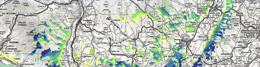
1 Marine Character Areas MCA 02 COLWYN BAY & RHYL FLATS Location and boundaries This Marine Character Area (MCA) is located in North Wales, covering the shallow coastal and inshore waters of Colwyn Bay and the extensive sand banks of Rhyl Flats, Chester Flats and Constable Bank. It takes in the full extent of Constable Bank and its associated shallow waters, as marked on the Marine Chart. The MCA s landward boundary extends from the eastern limits of Prestatyn, taking in the coastal settlements of Rhyl, Abergele and Colwyn Bay as far west as Little Orme s Head. The outer offshore boundary encloses the Rhyl Flats offshore windfarm and separates the shallow waters associated with the banks and flats from the deeper water further offshore (MCA 04). MCA 02 Colwyn Bay and Rhyl Flats - Page 1 of 9
2 Key Characteristics Key Characteristics Low-lying coastline backed by coastal levels associated with the broad mouth of the Vale of Clwyd to the eastern half of the area. High, exposed, rocky limestone hills and open headlands with intermediate developed bays to the western half of the area. Little Orme and Great Orme headlands form dramatic rugged landmarks. Long sandy beaches and shingle storm beaches. All the soft coastline is protected by various coastal defences including groynes, rock armour, beach recharging, walls and traditional promenades. Shallow waters (<20m) with gently shelving beaches and extensive network of offshore sandbank and flats. Significant peat exposures off Rhyl and at Rhos on Sea attesting to inundated land surfaces dating to the end of the last Ice Age. Extensive marine sediments of sand and gravel extending from the neighbouring Dee Estuary MCA and forming long, linear sandbanks running roughly parallel to the shore. Constantly shifting sandbanks with changing depths; hazards marked by numerous buoys, lights and fog horns. South Hoyle Channel and Inner Passage provided the approaches to Roman port of Chester. The present day navigation channels are maintained regularly by dredging. Most of the area is included in the Liverpool Bay SPA, designated for its international importance to overwintering populations of red-throated diver and common scoter. The flats, sand banks, bays and rocky shores are important for biodiversity, extensively designated including SPA, SAC and SSSI. Wave exposure generally low closer to shore, increasing in more open waters where the sheltering effect of Great Orme s Head (in MCA 03) diminishes. Developed coastline with many seaside resort towns, notably Llandudno (and pier), Colwyn Bay (and pier), Rhyl and Prestatyn, the latter having many caravan and chalet parks on their fringe. The coast serves as a traditional holiday destination. Recreational activity includes water sports such as jet skiing and speed boating. Tourist pleasure trips run from the pier at Llandudno, usually heading westwards around Great Orme s Head. Wales Coast Path and a popular cycleway run the length of the coastline. Collectively, the A55, A548 and main Holyhead to Chester railway line follow close to the coastline. Concentrations of documented shipwrecks in the approaches to Rhyl and Foryd harbours, also in locations where they were blown ashore from traditional anchorages. Both Colwyn Bay and Rhyl are popular shore and boat angling areas. Rhyl includes the main harbour along this stretch of coast. Historic military use of the seascape at Rhyl providing the last coastal fix for aircraft operating out of Hawarden and Sealand. Rhyl Flats Offshore Wind Farm forms a dominating offshore feature. The moving turbines are supplemented by further turbines beyond (in MCA 29). Limestone hills form a backdrop, in the east linking to the adjacent slopes of the Clwydian Range AONB. From further out to sea, views reach beyond to the mountains of Snowdonia National Park. MCA 02 Colwyn Bay and Rhyl Flats - Page 2 of 9

3 Natural Influences The Colwyn Bay and Rhyl Flats MCA comprises the north facing bays, wide sandy beaches and shallow sand banks of Colwyn Bay. It extends between the extensive sandy shoreline at Prestatyn in the east, taking in the bays of Penrhyn, Colwyn and Kinmel and Llandudno North Shore and includes the dramatic rocky headlands of Little Orme and Great Orme in the west, the latter bounding the MCA. The cliffs of Great Orme, flanking the western part of the MCA In the eastern half of the area, the MCA is backed by low lying coastal levels. The coastline is protected by extensive man-made coastal defences, providing some physical and visual separation between the foreshore and the development behind at Prestatyn, Rhyl and Towyn. The mouth of River Clwyd cuts across the sandy beach between Kinmel Bay and Rhyl. At Prestatyn, land gently rises up and then steepens dramatically to the craggy Clwydian Range peaks of Graig Fawr (153m AOD) and Y Foel (265m). In the west, the Carboniferous limestone headlands of Little Orme (141m) and Great Orme (207m) jut out into the sea but are perhaps more remarkable for their dramatic steep sea cliffs and their open heath and classic exposed limestone ruggedness. Internationally important coastal heathland provides rich habitat for higher plant communities including hoary rock-rose and spiked speedwell. These coastal and upland landscapes provide a dramatic backcloth to the MCA. The large open Colwyn Bay shelves very gradually north out to the Irish Sea, fronted by a vast expanse of flat sandy beaches constantly fed and modified by Longshore drift, as well as exposed and partially exposed sand banks. This area experiences a low tidal range and low to moderate wave stress. Offshore, the seas become rougher with areas of high wave stress where there are shallow waters over Constable Bank and Rhyl Flats. At low tide part of Rhyl Flats is less than half a metre below the water surface, forming a particular hazard to navigation. The constantly shifting sand creates an intricate network of sandbanks, including Chester Flats, connected to Rhyl Flats by the Tail of Middle Patch, and an extensive area of very shallow water in the east of the MCA. Coastal waters in the west gradually deepen to approximately 16 metres; Constable Bank cuts across this area reducing the depth along the outer MCA boundary. A yellow and black banded cardinal buoy marks the western extent of the bank at West Constable. MCA 02 Colwyn Bay and Rhyl Flats - Page 3 of 9
4 All of the MCA falls within the Liverpool Bay SPA, designated for it large populations of overwintering red throated divers and common scoters which feed in the rich waters around the network of sandbanks. Other biodiversity designations include part of the Menai Strait and Conwy Bay SAC in the west and several SSSIs reflecting the biodiversity importance of the area s extensive intertidal sands (comprising the wide beaches); sand banks, exposed calcareous rocks and limestone reefs also support important populations of shellfish, sponges and worms. The area s importance for its range of birdlife is also reflected in a large proportion designated by the RSPB as an Important Bird Area. There are significant areas of peat exposures off Rhyl and at Rhos-on-Sea attesting to inundated land surfaces dating to the end of the last Ice Age. Cultural/social influences The north coast s rich historic past is acknowledged as a Landscape of Outstanding Historic Interest at Little Orme s Head and Llandudno Bay, the area forming part of a medieval commote of Creuddyn. Evidence of early human habitation and exploitation of the sea s rich natural resources has been proven with the recording of post medieval (and earlier) fishtrap complexes at Rhos-on-Sea and Llandudno, the latter linked to the origins of the settlement as a small fishing village. More recent maritime history details relatively few wrecks in this seascape compared to neighbouring MCAs perhaps reflecting its historic character as one of transit. Historic vessels passing through tended to hug the coast to anchor before continuing into the Mersey or the Dee when the tide was right. Documented shipping losses cluster around the approaches to Foryd or Rhyl harbours, as well as the entrance of the Inner Passage heading towards the mouth of the Dee. There are also losses linked to vessels driven ashore from the traditional anchorages such as Abergele Road by north or north-westerly gales. These have included large steamships as well as traditional coasting schooners, sloops, and flats. Local folklore states that a ghost ship, the boat of Prince Madoc a Welsh explorer, was spotted off the coast at Abergele Road. It is claimed that Madoc discovered the Americas 300 years before Christopher Columbus. The pre-industrial settlement of Rhuddlan is located at the upper tidal extent of the Clwyd, and is the site of Rhuddlan Castle, which was established by Edward I in 1277 along with a new town on the site of earlier settlement. The concentric design of the castle represents an innovative masterpiece of medieval military architecture comparable to the more famous coastal castles further along the coast to the west, also constructed for Edward. The castle retains significant views into the estuary and along the coastal communication routes that served it, and the buried remains of docks and landing bays are likely to be preserved alongside the ruins. The whole site is designated as a Scheduled Monument. The seascapes of Rhyl were used by the military during WWII with the coastal flats associated with several forced landing and crashes, such as Boulton Paul Defiant which belly-landed on the beach in During the same period the area provided the last coastal fix for aircraft operating out of Hawarden and Sealand. MCA 02 Colwyn Bay and Rhyl Flats - Page 4 of 9

5 Llandudno Bay framed by Little Ormes Head The sandy beaches along this north coast of Wales have long been popular with visitors from the industrial towns of north-west England and from across Wales. The little village of Llandudno was visited by Daniell and Ayton on their voyage around the Welsh coast in The coastal towns of Llandudno (known as The Queen of Resorts ), Colwyn Bay, Rhyl and Prestatyn provide a wealth of traditional seaside recreational opportunities and attractions including the Grade II Listed Victoria Pier at Colwyn Bay and the Grade II* Llandudno Pier the longest in Wales, opened in 1877 as a major draw for Victorian holiday-makers. The surrounding coastal waters provide a range of further recreational opportunities, including water sports such as jet skiing and speed boating. Rhyl boasts the main harbour along this stretch of coast, however, access is limited due to the tides (drying heights of six metres) as well as the wreck of the sailing ship Ottowa which lies buried beneath the sand and mud obstructing the channel. A small harbouring area has also been created with the help of a breakwater at Rhos-on-sea. North Rhyl anchorage is situated within the Outer Passage offshore. Small charter boats can be seen strung along the South Hoyle Channel fishing in the shallow waters for whiting, plaice and dab. Inner Passage and South Hoyle Channel are used by craft approaching Welsh Channel and the Dee Estuary (MCA 01). Fishing activity is extensive throughout the MCA with the deeper waters being identified as an area for light otter trawling and light beam trawling. The network of shallower channels is used by fisherman with set nets. Waters off Llandudno are used for lobster and crab potting, whilst the shelving beaches are exploited by people hand gathering mussels and periwinkles. Llandudno Bay, Rhos Point and Llanddulas are also popular for beach net fishing. The 25 turbines of Rhyl Flats Offshore Wind Farm are situated approximately five miles off the coast, covering nearly four square miles within the shallow waters around Constable Bank and Rhyl Flats. To help mariners negotiate the turbines and shallow water the wind farm is marked by several buoys and horns. Submarine power cables cross the MCA linking the offshore windfarms to the land, connecting the electricity generated to the National Grid. The Wales Coast Path hugs the shoreline following the extensive promenade coastal defence at Llandudno, Rhos-on-sea, Colwyn Bay, Pensarn, Towyn, Rhyl and Prestatyn. The A55, A548 and main Holyhead to Chester railway line also collectively follow close to the coastline. MCA 02 Colwyn Bay and Rhyl Flats - Page 5 of 9

6 Aesthetic and perceptual qualities Development has a strong influence on the character of this MCA. In views from the sea, tall structures appear above the coastal defences; church spires, aerial masts, and Rhyl s iconic 240 feet high Sky Tower, all feature in views back to shore. Views of the impressive Grade I Listed 19 th century Gwrych Castle nestled on the wooded slopes above Abergele can also be gained from the sea, adding a contrasting sense of time depth behind the more modern developments and infrastructure below. The rising hills of the Clwydian Range and Dee Valley AONB feature as a dramatic backdrop to the south-east of the MCA, whilst views to the imposing mountains of Snowdonia National Park often shrouded in low cloud/mist feature to the south-west. The area s long-standing popularity as a holiday destination results in a busy seascape with activities along the coast and out to sea creating much movement and colour. The lithograph below from 1850 captures this scene particularly effectively. The coastline is brought to life particularly in the summer months, whilst the scene can be dramatically different in mid-winter, with facilities closed down and beaches relatively empty with natural influences, notably bracing winds, replacing human activity. Rhyl from the sea ; a lithograph c.1850, ( Crown Estate, 2013). The 25 offshore turbines (134 metres to blade tip) which make up the Rhyl Flats Wind Farm often dominate offshore views, seen in conjunction with further offshore turbines at Gwynt-y-Mor Wind Farm and North Hoyle Wind Farm to the east. The visual distinction between individual offshore wind farm developments is blurred as turbine fields overlap. These further add to the developed northern coast and define the character of the waters at the outer extent of the MCA. The presence of the turbines reduces the overall sense of tranquillity and remoteness but does not affect the feeling of exposure associated with the vast open sandy beaches. MCA 02 Colwyn Bay and Rhyl Flats - Page 6 of 9
7 The Visual Resource Maps (VRM) that follow provide a more detailed spatial representation of the visibility of this MCA from the surrounding land in Wales. Please refer to the technical report for an explanation of how these maps were generated and how they should be interpreted. The first map shows land with views to this MCA, the darker shading indicating land where from which more of this MCA is visible. The second map shows sea visible from land, the warmer colours being areas of sea that are visible from more places on land. This comes from a national assessment of Wales so the results do not relate specifically to this MCA, whose boundary is overlaid for location only. The four individual versions show how the results vary depending on how far inland hypothetical viewers are located. MCA 02 Colwyn Bay and Rhyl Flats - Page 7 of 9


 Map Scale @")
8 E km 02: Colwyn Bay and Rhyl Flats Wales Inshore Marine Plan Area Land with sea views (Percentile) < 20 (Lowest) W l a s e Wales National Seascape Assessment Land with Views of: MCA 02: Colwyn Bay and Rhyl Flats Source: LUC, NRW, OceanWise (Highest) Map A4: 1:350,000 CB: EB:Goosen_V LUCLON _021_VRM_Maps_DDP_LandWithSeaViews_export_map_1 25/03/2015 British Crown and OceanWise Ltd, All rights reserved License No. EK Crown copyright and database rights 2015 Ordnance Survey Hawlfraint y Goron a hawliau cronfa ddata 2015 Arolwg Ordnans

 Map Scale @ A4: 1:350,000 Relative Visibility")


9 0-1 km from High Water Mark 1-5 km from High Water Mark 5-10 km from High Water Mark km from High Water Mark E km 02: Colwyn Bay and Rhyl Flats Wales Inshore Marine Plan Area Wales National Seascape Assessment Visibility of sea from land (percentile) <10 (Lowest) (Highest) Map A4: 1:350,000 Relative Visibility of the Sea Surface from Viewers on Land MCA 02: Colwyn Bay and Rhyl Flats CB: EB:Goosen_V LUCLON _022_VRM_Maps_DDP_Sea_Visibility_ 27/05/2015 British Crown and OceanWise Ltd, All rights reserved License No. EK Source: LUC, NRW, OceanWise Crown copyright and database rights 2015 Ordnance Survey Hawlfraint y Goron a hawliau cronfa ddata 2015 Arolwg Ordnans W l e a s
Marine Character Areas MCA 23 SOUTH PEMBROKESHIRE OPEN WATERS. Location and boundaries
 Marine Character Areas MCA 23 SOUTH PEMBROKESHIRE OPEN WATERS Location and boundaries This Marine Character Area (MCA) encompasses the waters surrounding the southern coast the Pembrokeshire Peninsula.
Marine Character Areas MCA 04. Location and boundaries NORTH WALES OPEN WATERS
 Marine Character Areas MCA 04 NORTH WALES OPEN WATERS Location and boundaries This Marine Character Area (MCA) covers the outer inshore waters of North Wales, coinciding broadly with the coastline stretching
Marine Character Areas MCA 5. Location and boundaries NORTH-WEST ANGLESEY OPEN WATERS
 Marine Character Areas MCA 5 NORTH-WEST ANGLESEY OPEN WATERS Location and boundaries This Marine Character Area (MCA) comprises the outer inshore waters extending from the northern Anglesey coastline to
St Brides Bay coastal waters east
 No: 21 Seascape Character Area Name: St Brides Bay coastal waters east Looking south from Newgale Nolton Haven 21-1 View from Little Haven across St Bride s Bay Summary Description View across Broad Haven
Marine Character Areas MCA 10 MENAI STRAIT. Location and boundaries
 Marine Character Areas MCA 10 MENAI STRAIT Location and boundaries This Marine Character Area (MCA) covers the main channelled section of the Menai Strait, from Abermenai Point in the west to the fringes
Tenby and Caldey Island
 No: 39 Seascape Character Area Name: Tenby and Caldey Island Tenby with spire from the south Tenby North Beach with harbour Tenby- sailing dinghy activity off North Beach View across to Caldey island from
Surfers Against Sewage Are Calling For A Review of the UK s Bathing Water Sample Sites.
 Surfers Against Sewage Are Calling For A Review of the UK s Bathing Water Sample Sites. Welsh Report Surfers Against Sewage (SAS) believe the weekly bathing water samples required by the EU Bathing Water
Marine Character Areas MCA 06. Location and boundaries NORTH ANGLESEY COASTAL WATERS
 Marine Character Areas MCA 06 NORTH ANGLESEY COASTAL WATERS Location and boundaries This MCA covers the north-facing coast of Anglesey and its coastal waters, including the islands of West Mouse, Middle
Coastal Processes Day Criccieth
 Coastal Processes Rivers (Conwy) Rivers (Peris) Urban Studies Lowland Glaciation Tourism and National Parks Soils Sand Dunes Upland Glaciation Rural Settlements The Centre and Staff Fieldwork Equipment
Map 8: Ayrshire Coast: Ardrossan North Bay to Stevenston Pier Map Content Descriptions
 Map 8: Ayrshire Coast: Ardrossan North Bay to Stevenston Pier Map Content Descriptions 1. Built Heritage and Archaeology A total of twenty four sites were recorded in the area covered by Map 8. Of these
FishRamp Irish Sea VMS
 2015 FishRamp Irish Sea VMS Laurence Rooney AFBI 24/02/2015 Contents Summary Page 2 Data and Method details Page 4 Overview of competing interests Page 6 GB designated Wind-farms in the Irish Sea Page
Llandudno Beach Management Plan and Options Appraisal
 Llandudno Beach Management Plan and Options Appraisal August, 2017 G.B. Edwards BEng (Hons) CEng FICE Head of, Mochdre Offices, Conway Road, Mochdre, Colwyn Bay, LL28 5AB. Tel. (01492) 574000 Fax. (01492)
SHOREHAM BEACH LOCAL NATURE RESERVE
 SHOREHAM BEACH LOCAL NATURE RESERVE Coastal Geography Education Programme 2014-15 S. Savage 2014 COASTAL GEOGRAPHY OPPORTUNITIES Shoreham Beach Shoreham Beach is a shingle spit formed over many centuries
7 MARINE FISH 7.1 INTRODUCTION
 7 MARINE FISH 7.1 INTRODUCTION There are two components of the marine fish monitoring for FEPA reporting purposes: analysis of annual CEFAS trawl surveys and consultations with local fishermen through
A full version of this guide is available with photos online at
 Llyn.info Beach Guide Printable version to take with you the use of any information on Llyn.info is at the risk of the user and Llyn.info, it s webmaster nor any of it s advertisers can be held responsible
Overview. Beach Features. Coastal Regions. Other Beach Profile Features. CHAPTER 10 The Coast: Beaches and Shoreline Processes.
 Overview CHAPTER 10 The Coast: Beaches and Shoreline Processes Coastal regions constantly change. The beach is a dominant coastal feature. Wave activity continually modifies the beach and coastal areas.
St Brides Bay coastal waters north
 No: 20 Seascape Character Area Name: St Brides Bay coastal waters north Looking west from near Caerfai to Ramsey Island in distance East from Caerfai Bay East from near Dinas Fach Solva harbour 20-1 Summary
Chesil Beach, Dorset UK High energy, shingle coastline. Brighton Beach, Sussex UK Pebble beach
 Beaches: Depositional landform Extends from the highest high tide to the lowest low tide. Very important temporary store in coastal system. Accretion: sediment returning to the visible portion of a beach
Shorelines Earth - Chapter 20 Stan Hatfield Southwestern Illinois College
 Shorelines Earth - Chapter 20 Stan Hatfield Southwestern Illinois College The Shoreline A Dynamic Interface The shoreline is a dynamic interface (common boundary) among air, land, and the ocean. The shoreline
Marine Character Areas MCA 15 CARDIGAN BAY (NORTH) & ESTUARIES. Location and boundaries
 & ESTUARIES. Location and boundaries") Marine Character Areas MCA 15 CARDIGAN BAY (NORTH) & ESTUARIES Location and boundaries This Marine Character Area (MCA) comprises the coastal waters of the northern part of Cardigan Bay, stretching from
Marine Character Areas MCA 15 CARDIGAN BAY (NORTH) & ESTUARIES Location and boundaries This Marine Character Area (MCA) comprises the coastal waters of the northern part of Cardigan Bay, stretching from
Beach profile surveys and morphological change, Otago Harbour entrance to Karitane May 2014 to June 2015
 Beach profile surveys and morphological change, Otago Harbour entrance to Karitane May 2014 to June 2015 Prepared for Port Otago Ltd Martin Single September 2015 Shore Processes and Management Ltd Contact
3 Maps and Charts In order to navigate we need to use some form of map. The two choices are nautical charts, or land maps.
 13 3 Maps and Charts In order to navigate we need to use some form of map. The two choices are nautical charts, or land maps. Charts Nautical Charts only show the land detail that is visible from the sea.
Cymyran Strait and Rhoscolyn
 Borthwen and Rhoscolyn Beacon - Photo: www.pixaerial.com 7 No. 7 Grade B 18km OS Sheet 114 Tidal Port Liverpool Start Four Mile Bridge (280783) Finish Porth Dafarch (233800) HW/LW are around 1 hour 30
The Sea Geography Notes JC-Learn. JC-Learn. Geography Notes The Sea. 1 P a g e
 JC-Learn Geography Notes The Sea 1 P a g e The Sea *Here, you can choose to study the chapter on glaciation or the one on the sea, or even both, because whenever these topics come up in the Junior Cert
GUIDE to FISH & FISHING on the NORTH YORK MOORS COAST
 GUIDE to FISH & FISHING on the NORTH YORK MOORS COAST HISTORY Fishing has always played an important part in North Yorkshire s maritime heritage. The industry still plays a significant role in everyday
How To Enter Kushiro Port and Things To Be Aware of When Entering
 How To Enter Kushiro Port and Things To Be Aware of When Entering 1.How to enter Kushiro Port (1)How to enter the East Area When entering the port from Nemuro, navigate while maintaining a safe distance
AMENITY SIGNIFICANCE OF EFFECT TABLES
 ABERDEEN HARBOUR EXPANSION PROJECT November 2015 Volume 3: Technical Appendices Appendix 17-A LAND/SEASCAPE & VISUAL AMENITY SIGNIFICANCE OF EFFECT TABLES 17-A LAND/SEASCAPE AND VISUAL AMENITY SIGNIFICANCE
Weatherman Walking Sully to Penarth Approximate distance: 5 miles End Start
 Approximate distance: 5 miles For this walk we ve included OS grid references should you wish to use them. 4 End Start 2 3 N W E 1 S Reproduced by permission of Ordnance Survey on behalf of HMSO. Crown
West Coast Anchorages
 West Coast Anchorages This document aims to catalogue a number of anchorages along the West Coast of Tasmania where shelter may be sought. In addition the degree of protection from the wind, and holding
Coastal management has lagged behind the growth in population leading to problems with pollution
 Fifty percent of the population of the industrialized world lives within 100 km of a coast. Coastal management has lagged behind the growth in population leading to problems with pollution and natural
Visiting Lake Macquarie
 Visiting Lake Macquarie Lake Macquarie is the largest coastal salt water lake in Australia and is a prime boating destination for both small and large vessels. Many sailing regattas and fishing activities
The Physical and Human Causes of Erosion. The Holderness Coast
 The Physical and Human Causes of Erosion The Holderness Coast By The British Geographer Situation The Holderness coast is located on the east coast of England and is part of the East Riding of Yorkshire;
page - Laboratory Exercise #5 Shoreline Processes
 page - Laboratory Exercise #5 Shoreline Processes Section A Shoreline Processes: Overview of Waves The ocean s surface is influenced by three types of motion (waves, tides and surface currents). Shorelines
LOFOTEN ISLAND KAYAK TOUR by JAMES BAXTER
 LOFOTEN ISLAND KAYAK TOUR by JAMES BAXTER This is a short account of a 9 day kayak trip round the Lofoten Islands off the west coast of Northern Norway and just above the Arctic Circle. They form a 150
SANDBANKS COAST PROTECTION
 SANDBANKS COAST PROTECTION David Robson, Senior Engineer, Coastal & Drainage Team Borough of Poole Leisure Services (T) 01202 265265 (E) d.robson@poole.gov.uk May 2003 SANDBANKS COAST PROTECTION Introduction
General Coastal Notes + Landforms! 1
 General Coastal Notes + Landforms! 1 Types of Coastlines: Type Description Primary Coast which is essentially in the same condition when sea level stabilized Coastline after the last ice age, younger.
NORTH HAVEN NORTH HAVEN SLSC
 NORTH HAVEN NORTH HAVEN SLSC Patrols: November to March, weekends and public holidays North Haven beach is the product of a major redevelopment of the northern part of the Adelaide coast. In the 1980s,
Reading Material. Inshore oceanography, Anikouchine and Sternberg The World Ocean, Prentice-Hall
 Reading Material Inshore oceanography, Anikouchine and Sternberg The World Ocean, Prentice-Hall BEACH PROCESSES AND COASTAL ENVIRONMENTS COASTAL FEATURES Cross section Map view Terminology for Coastal
Estuarine Shoreline Stabilization
 Estuarine Shoreline Stabilization Property Owner s Guide to Determining the Most Appropriate Stabilization Method Estuarine shorelines are dynamic features that experience continued erosion. Land is lost
Marginal Marine Environments
 Marginal Marine Environments Delta: discrete shoreline protuberances formed where rivers enter oceans, semi-enclosed seas, lakes or lagoons and supply sediment more rapidly than it can be redistributed
Australian Coastal Councils Conference
 Australian Coastal Councils Conference Kiama March 2019 Where Has My Beach Gone? (and what can I do about it?) Dr Andrew McCowan Water Technology Where Has My Beach Gone? Where Has My Beach Gone? Where
Dodger Channel. Chart 3671 Map 92C/ N W The southern section is the favoured anchoring area. Good holding. Settled weather only.
 Vancouver Island. West Coast. South to North Burlo Island Cove. Chart 3646. Map 92C/14 48 49N 125 08W At the head of Bamfield Inlet. Anchor on the west or east of Burlo Island. Drying flats. Good holding
Geography Revision Weekend Snowdonia. Sample Itinerary
 Geography Revision Weekend Snowdonia Sample Itinerary Name Bore da Good morning Prynhawn da Good afternoon Noswaith dda Good evening Nos da Goodnight Helô Hello Sut mae? How are you? Croeso Welcome Hwyl
Citizen Science Based Survey GBR Far North Dive Trip 2016 April 18-26
 Citizen Science Based Survey GBR Far North Dive Trip 2016 April 18-26 Chris Roelfsema Karen Johnson Douglas Stetner Trevor Baerenger Peran Brady May 2016 GBR Far North Citizen Science Trip 5 May 2016 1
IFM Specialist Conference 2018
 IFM Specialist Conference 2018 Managing Fisheries in Estuarine and Coastal Waters Mandy Knott Senior Scientist 23rd May 2018 Photo: Oystercatchers feeding on Foulney mussel bed December 2015 - NWIFCA What
Warm-up # 7 A day 5/17 - B day 5/18 UPDATE YOUR TABLE OF CONTENTS
 Warm-up # 7 A day 5/17 - B day 5/18 UPDATE YOUR TABLE OF CONTENTS Question: List all examples of surface water on Earth. Answer: Rivers and streams, lakes and reservoirs, (ponds) wetlands, estuaries and
Shoreline Response to an Offshore Wave Screen, Blairgowrie Safe Boat Harbour, Victoria, Australia
 Shoreline Response to an Offshore Wave Screen, Blairgowrie Safe Boat Harbour, Victoria, Australia T.R. Atkins and R. Mocke Maritime Group, Sinclair Knight Merz, P.O. Box H615, Perth 6001, Australia ABSTRACT
COASTAL SYSTEMS WAVE ENERGY
 WAVE ENERGY The energy of a wave determines its ability to erode and transport material on the coast Wave energy depends on the fetch, the distance the wind has blown the wave Wind strength and wind duration
1.5 How do ocean waves and currents change the face of coastal areas? (Chapter 3)
") 1.5 How do ocean waves and currents change the face of coastal areas? (Chapter 3) 1. Hydraulic Action/Pressure - air being forced into crack in rocks. 2. Corrosion (Solution) Minerals such as calcium carbonate
1.5 How do ocean waves and currents change the face of coastal areas? (Chapter 3) 1. Hydraulic Action/Pressure - air being forced into crack in rocks. 2. Corrosion (Solution) Minerals such as calcium carbonate
Bathing Water Profile - Carne (2017)
") Bathing Water Profile - Carne (2017) Bathing Water: Bathing Water Code: Local Authority: River Basin District: Monitoring Point: Carne IESEBWC050_0000_0300 Wexford County Council South Eastern 312952E,
Bathing Water Profile - Carne (2017) Bathing Water: Bathing Water Code: Local Authority: River Basin District: Monitoring Point: Carne IESEBWC050_0000_0300 Wexford County Council South Eastern 312952E,
Q1. What are the primary causes/contributors to coastal erosion at Westshore and the concept of longshore / littoral drift.
 Q1. What are the primary causes/contributors to coastal erosion at Westshore and the concept of longshore / littoral drift. In order of (timing related) contribution to present problem 1. Beach is too
Chart Features Maritime maps and Admiralty charts have these features:
 Introduction to Charts A chart or map of the area is an important safety item to carry on board. It allows the Master to obtain knowledge of the area to be travelled, and indicates the navigable channels
Apostle Islands National Seashore
 Apostle Islands National Seashore David Speer & Phillip Larson October 2 nd Fieldtrip Report Table of Contents Introduction 1 Stop 1: Apostle Island Boat Cruise 1 Stop 2: Coastal Geomorphology 5 Stop 3:
Map Introduction: Grimsay Map 1
 32 Map Introduction: Map This map section covers the western half of the island of. It extends from the south west coast of Bagh Scotbheinn and runs northwards, past the causeway connecting to Benbecula
Chiswell and Chesil Beach (to Wyke Narrows) 6a02 and 6a03 SUMMARY OF PREFERRED PLAN RECOMMENDATIONS AND JUSTIFICATION
 6a02 and 6a03 SUMMARY OF PREFERRED PLAN RECOMMENDATIONS AND JUSTIFICATION") Location reference: Policy Unit reference: Plan: Chiswell and Chesil Beach (to Wyke Narrows) 6a02 and 6a03 SUMMARY OF PREFERRED PLAN RECOMMENDATIONS AND JUSTIFICATION The long term aim for this section
Location reference: Policy Unit reference: Plan: Chiswell and Chesil Beach (to Wyke Narrows) 6a02 and 6a03 SUMMARY OF PREFERRED PLAN RECOMMENDATIONS AND JUSTIFICATION The long term aim for this section
Admiralty Leisure Folio SC5601 East Devon and Dorset Coast, Exmouth to Christchurch
 Admiralty Leisure Folio SC5601 East Devon and Dorset Coast, Exmouth to Christchurch The Notices to Mariners (NMs) listed below apply to the latest edition of SC5601 (11 th Edition) published on 24 th March
Low-crested offshore breakwaters: a functional tool for beach management
 Environmental Problems in Coastal Regions VI 237 Low-crested offshore breakwaters: a functional tool for beach management K. Spyropoulos & E. Andrianis TRITON Consulting Engineers, Greece Abstract Beach
Montessori for Everyone 2013 Types of Coastlines
 Coast The coast is the part of the land that borders the sea. It is subject to constant change, as the result of the waves and deposits carried by water onto the land. Coastline The coastline is where
The Case of the Disappearing Shoreline
 Name The Case of the Disappearing Shoreline Humans change the earth's climate in many ways. One change is the increase of carbon dioxide in the atmosphere. As we burn more fossil fuels, we release more
Oceans and Coasts. Chapter 18
 Oceans and Coasts Chapter 18 Exploring the oceans The ocean floor Sediments thicken and the age of the seafloor increases from ridge to shore The continental shelf off the northeast United States Constituent
TITLE: COASTAL EROSION AND LANDFORMS.
 TITLE: COASTAL EROSION AND LANDFORMS. AIM: What are the factors that influence the formation of coastal features along Fishing Pond beach Trinidad? LOCATION OF FIELD STUDY: The study was carried out in
Anatomy of Coastal Regions
 The Coast I. BEACH ANATOMY Anatomy of Coastal Regions Terms for different parts of beaches and coastal regions Are all about ENERGY- ie, where the ocean s energy Mostly through tides and waves, and shape
Management Area 19 Management Area 20 Management Area 21 Management Area 22. Mount s Bay West (The Greeb to Point Spaniard)
") PDZ: 8 Mount s Bay West (The Greeb to Point Spaniard) (Including Marazion and St Michael s Mount) Management Area 19 Management Area 20 Management Area 21 Management Area 22 Mount s Bay West (The Greeb
PDZ: 8 Mount s Bay West (The Greeb to Point Spaniard) (Including Marazion and St Michael s Mount) Management Area 19 Management Area 20 Management Area 21 Management Area 22 Mount s Bay West (The Greeb
Notice of operations at London Array Offshore Wind Farm
 London Array Ltd. Construction Management Port of Ramsgate Military Road Ramsgate CT11 9LG www.londonarray.com Notice of operations at London Array Offshore Wind Farm Date of Notice: June 19th 2011 Notice
Coastal Change and Conflict
 Coastal Change and Conflict Outline of the Topic Contrasting Coasts why do all coasts not look the same? Geology of the coast the impact rock structure has on the coastline Waves Constructive and destructive
For more information: Photography: Rijkswaterstaat (Leo Linnartz, Carrie de Wilde, Jurriaan Brobbel, Joop van Houdt), Deltares
, Deltares") Investing in your future. This project was made possible with support from the European Regional Development Fund. Photography: Rijkswaterstaat (Leo Linnartz, Carrie de Wilde, Jurriaan Brobbel, Joop van
Investing in your future. This project was made possible with support from the European Regional Development Fund. Photography: Rijkswaterstaat (Leo Linnartz, Carrie de Wilde, Jurriaan Brobbel, Joop van
Critical Habitat. Those who contributed to this research are:
 TRADITIONAL ECOLOGICAL KNOWLEDGE PORT MOUTON BAY TRADITIONAL ECOLOGICAL KNOWLEDGE PORT MOUTON BAY Critical Habitat The community of Port Mouton Bay NS has a sound economic base in the lobster fishery.
CHAPTER 8 ASSESSMENT OF COASTAL VULNERABILITY INDEX
 124 CHAPTER 8 ASSESSMENT OF COASTAL VULNERABILITY INDEX 8.1 INTRODUCTION In order to assess the vulnerability of the shoreline considered under this study against the changing environmental conditions,
Natural Bridges Field Trip Activity
 Natural Bridges Field Trip Activity This is due in class on MONDAY- March 1 - not in sections! Name TA: NOTE ON THE GRADING OF THIS ASSIGNMENT: Many of the questions below (especially in the tidepool part)
Nearshore Sediment Transport What influences the loss of sediment on Beaches? - Waves - Winds - Tidal Currents - River discharge - Runoff
 Tides & Beaches Nearshore Sediment Transport What influences the loss of sediment on Beaches? - Waves - Winds - Tidal Currents - River discharge - Runoff Oceans Ocean Topography Physical Structure of the
Plot the Path. Mary Anne Otten. lesson three
 Plot the Path Mary Anne Otten lesson three Subject/Grade: Grade 2, Math, Social Studies, Science Duration: one class period Materials needed: Per class: Day the Great Lakes Drained Away by Charles Ferguson
DRAFT. Management Area 19 Management Area 20 Management Area 21 Management Area 22
 PDZ: 8 Mounts Bay West (The Greeb to Point Spaniard) (Including Marazion and St Michael s Mount) Management Area 19 Management Area 20 Management Area 21 Management Area 22 Mounts Bay West (The Greeb to
Anchoring Is Important
 BCC Sailing Classes - Third Theory Anchoring Anchoring Is Important 1 The Anchor is your last resort. Anchoring Keep off a lee shore. Needs to be shaped (type of anchor) to bury in the type of bottom for
Plot the Path into the Harbor
 Plot the Path into the Harbor By Mary Anne Otten, Rudyard Area Schools and Joan Chadde, Michigan Technological University Subject/Grade: Grade 3 6, Math, Social Studies, Science Duration: 35 minutes Lesson
LANDSCAPE UNIT 72 Paku
 Location Map LANDSCAPE VALUES Landscape Unit No. 72 Description: Paku KEY LANDSCAPE FACTORS / VARIABLES LANDSCAPE UNIT 72 Paku The Bio-physical Landscape Naturalness / Natural Science Factors Land Forms
Skomer Marine Conservation Zone Byelaws and Codes of Conduct
 Skomer Marine Conservation Zone Byelaws and Codes of Conduct BYELAWS The Marine Conservation Zone (MCZ) byelaws are summarised below. A copy of the MCZ byelaws is available free on request. The MCZ s byelaws
1.5 Understand how ocean waves and currents change the face of coastal areas. (Chapter 3)
") 1.5 Understand how ocean waves and currents change the face of coastal areas. (Chapter 3) 1. Hydraulic Action/Pressure - air being forced into crack in rocks. 2. Corrosion (Solution) Minerals such as calcium
1.5 Understand how ocean waves and currents change the face of coastal areas. (Chapter 3) 1. Hydraulic Action/Pressure - air being forced into crack in rocks. 2. Corrosion (Solution) Minerals such as calcium
Coast Survey Stretch 03 Seaview High Street to Sandown Zoo
 Coast Survey Stretch 03 Seaview High Street to Sandown Zoo Overview map of the stretch Introduction The route starts at the attractive village of Seaview, through the wooded Priory Bay, passing the remains
Marine Ecosystems. Aquatic Ecosystems Section 2
 Marine Ecosystems Marine ecosystems are located mainly in coastal areas and in the open ocean. Organisms that live in coastal areas adapt to changes in water level and salinity. Organisms that live in
Environmental Protection on the Gold Coast of Queensland, Australia. 1. What is the appeal of the Gold Coast to tourists?
 Environmental Protection on the Gold Coast of Queensland, Australia Sections 1. What is the appeal of the Gold Coast to tourists? 2. How are Gold Coast visitor trends changing? 3. How can the impacts of
HARBOUR SEDIMENTATION - COMPARISON WITH MODEL
 HARBOUR SEDIMENTATION - COMPARISON WITH MODEL ABSTRACT A mobile-bed model study of Pointe Sapin Harbour, in the Gulf of St. Lawrence, resulted in construction of a detached breakwater and sand trap to
Coasts. 1. Coastal Processes. 1.1 Coastal erosion. 1.2 Sediment transport. Coastal Processes and Landforms. i. Hydraulic action
 Coasts Coastal Processes and Landforms 1. Coastal Processes 1.1 Coastal erosion i. Hydraulic action When waves strike against a rock surface, the waves trap air in the rock joints. This air is compressed
Highland Region MAP. No. 11 St. Marys River No. 12 West River No. 13 Wallace River No. 14 Toney River No. 15 Northumberland Strait
 Highland Region MAP No. 11 St. Marys River No. 12 West River No. 13 Wallace River No. 14 Toney River No. 15 Northumberland Strait 14 Route: No. 11 St. Marys River Rating: Intermediate Advanced Length:
ROUTE 2. Bateau Channel. Topographic Map 31 C/8 Navigation Charts 1438/39 Reference Maps
 Topographic Map 31 C/8 Navigation Charts 1438/39 Reference Maps ROUTE 2 Bateau Channel The shoreline marshes of the Bateaux Channel team with life. Wetlands provide breeding habitat for amphibians, fish
coastal Safety challenge Leaders notes
 coastal Safety challenge Leaders notes Leaders notes COASTAL SAFETY CHALLENGE INTRODUCTION The Scout Association is pleased to be working with The Maritime and Coastguard Agency (MCA) to bring you the
Chapter 10 Lecture Outline. The Restless Oceans
 Chapter 10 Lecture Outline The Restless Oceans Focus Question 10.1 How does the Coriolis effect influence ocean currents? The Ocean s Surface Circulation Ocean currents Masses of water that flow from one
Case Study 3. Case Study 3: Cebu Island, Philippines MPA Network 10
 Case studies of mpa networks Case Study 3: Cebu Island, Philippines MPA Network 10 Location and background Cebu Island in the Philippines lies in the center of the Visayan Islands, known as an area high
Studland Bay Context and Learning Aims
 Studland Bay Enquiry 7: How are coastal processes affecting Studland Bay? Context and Learning Aims Pupils will be supported in and outside of the classroom to: Identify; describe and explain the physical
Formation and characteristics of different types of beaches
 Activity Title: Formation and characteristics of different types of beaches Focusing questions What different types of beaches are there in New Zealand? How are estuaries different to open coastal sandy
There are toilets at Manningtree Station, Flatford (close to the hump back bridge) and in Dedham.
 and in Dedham.") Arriving by Train Main Features of the Walk Outline Route Employs particularly attractive paths, many of which offer impressive views across Dedham Vale. Includes a section along the tidal section of the
Arriving by Train Main Features of the Walk Outline Route Employs particularly attractive paths, many of which offer impressive views across Dedham Vale. Includes a section along the tidal section of the
LAB: WHERE S THE BEACH
 Name: LAB: WHERE S THE BEACH Introduction When you build a sandcastle on the beach, you don't expect it to last forever. You spread out your towel to sunbathe, but you know you can't stay in the same spot
Bay of Fundy Estuary Profile
 s The is a sub-basin of the Bay of Fundy along the northwestern shore of Nova Scotia and at the western end of the Annapolis Valley. The Annapolis River is the major water source flowing into the estuary.
Habitat Development: Habitat Boulders Lawson Pier Foreshore Enhancement
 Habitat Development: Habitat Boulders Improve the existing habitat by stabilising beach sediments. Increase biodiversity by creating new habitats and colonisation opportunities. Loose cobble is unstable;
SECTION II NM 26/10 NAVIGATION PUBLICATIONS ALMANACS CORRECTIONS
 NAVIGATION PUBLICATIONS ALMANACS CORRECTIONS NAUTICAL ALMANAC Ed 2011 NEW EDITION (NGA) 26/10 SAILING DIRECTIONS CORRECTIONS PUB 140 8 Ed 2010 NEW EDITION (NGA) 26/10 COAST PILOT CORRECTIONS COAST PILOT
MAPS AND AERIAL PHOTOS REVISION
 MAPS AND AERIAL PHOTOS REVISION IF THE FOLLOWING COMES UP IN THE SHORT QUESTIONS REMEMBER SCALE OF 1:1,100,000,000 MAP FROM A WORLD ATLAS LARGE AREAS WITH LITTLE DETAIL 1:250,000 SCALE OF CAR ATLAS MAP
NYS Coastal Waters. Water Resources of NYS: THE NATURE of the COASTAL ZONE. NYS Coastal Waters. NYS Coastal Atlas. Coastal Zone Management 10/10/2014
 Water Resources of NYS: THE NATURE of the COASTAL ZONE NYS Coastal Waters NYS is the only state to border the Atlantic Ocean and the Great Lakes (Lakes Erie and Ontario). Great Lakes shoreline: 577 miles
National Maritime Center
 National Maritime Center Providing Credentials to Mariners (Sample Examination) Page 1 of 8 Choose the best answer to the following Multiple Choice Questions. 1. Assume that your vessel has just entered
EfFl(5)Y.20s 53 13' 0N., 4 43' 4W.
Y.20s 53 13' 0N., 4 43' 4W.") Admiralty Leisure Folio SC5609 North West Wales including Menai Strait The Notices to Mariners (NMs) listed below apply to the latest edition of SC5609 (4 th Edition) published on 22 nd March 2018. Temporary/Preliminary
Admiralty Leisure Folio SC5609 North West Wales including Menai Strait The Notices to Mariners (NMs) listed below apply to the latest edition of SC5609 (4 th Edition) published on 22 nd March 2018. Temporary/Preliminary
LIST OF NOTICES TO MARINERS 2017 PAC 201 JUAN DE FUCA STRAIT AND STRAIT OF GEORGIA, FIRST EDITION, 2012
 1 Chapter 1 After paragraph 154 Insert: 154.1 Pacific Gateway Marina (250-412-5509) is located west of the community wharf. Moorage, gas, diesel, a launching ramp and deep water berths for sailboats are
Lecture Outlines PowerPoint. Chapter 15 Earth Science, 12e Tarbuck/Lutgens
 Lecture Outlines PowerPoint Chapter 15 Earth Science, 12e Tarbuck/Lutgens 2009 Pearson Prentice Hall This work is protected by United States copyright laws and is provided solely for the use of instructors