Byron Residents' Group Submission to NSW Coastal Panel Belongil Rock Walls
|
|
|
- Dwayne Carr
- 5 years ago
- Views:
Transcription
1 Dailan Pugh 15 Tallowwood Cres Byron Bay, 2481 on behalf of Byron Residents' Group Byron Residents' Group Submission to NSW Coastal Panel Belongil Rock Walls This is a submission to: Development Application number: CP Ralph Lauren Pty Ltd, Coastal Protection Works at 1 and 1A Don Street, Byron Bay Development Application number: CP Robert Watson, Coastal Protection Works at 44 and 48 Childe Street, Byron Bay Development Application number: CP Stewartville Pty Ltd, Coastal Protection Works at 6B Childe Street, Byron Bay Development Application number: CP Michael Siddle, Coastal Protection Works at 28 and 28A Childe Street, Byron Bay These 4 proposals for the construction of rock walls at Belongil are strongly objected to. Byron Residents Group is a registered community association that recognises the unique area in which we live and works to protect and preserve our significant biodiversity. We seek to ensure a proper balance between residential and commercial interests and support sustainable development and projects that will preserve, protect and enhance the environmental values of our town and the amenity of its residents. Byron Residents Group were represented, along with Byron Environmental and Conservation Organisation (BEACON), by Dailan Pugh on the CZMP Byron Bay Embayment Project Reference Group in BEACON has an involvement in the preparation of the Byron CZMP stretching back to 1999, with Dailan Pugh representing BEACON from Our consideration of the exhibited documents was severely hampered by the removal of the Appendices from three of the exhibited proposals, exempting them from scrutiny. This is extremely poor practice on behalf of the Coastal Panel. This submission focuses on the proposed management of Belongil beach in Byron Shire The proposals by Ralph Lauren Pty Ltd, Robert Watson, Stewartville Pty Ltd and Michael Siddle involve construction of sections of rock seawalls which will undoubtedly cause loss of the beach in front of the walls and increased erosion of Belongil Beach in front of the walls, and will have downdrift impacts on Belongil Spit, the mouth of Belongil Creek, Endangered Ecological Communities, and the Belongil Shorebird Precinct. There can be no doubt that the beach in front of the walls will 1
2 become unusable for public recreation with increasing frequency because of these works, which will result in multi-million dollars annual costs to the local economy. For this submission the individual Development Applications and Statements of Environmental Effects were reviewed, though these were considered so inadequate that it would be a waste of time trying to critique them individually, hence they have mostly been dealt with collectively herein. This enables their cumulative impacts to be considered. Each section of wall will make a significant contribution to the overall impacts. This submission was prepared in haste. Most of the information presented herein was collated in response to a proposal by Byron Shire Council in their draft 2016 CZMP to rebuild and fill in the gaps in the existing rock and rubble walls along Belongil beach. These four proposals represent a significant part of those works, and, if approved, will undoubtedly lead to more applications which will result in substantially the same outcome as rebuilding them in their entirety, but without any mitigation measures what-so-ever. This incremental approach, without due consideration of the cumulative impacts and implementation of mitigation works should be rejected by the Coastal Panel. The proposals to replace ad-hoc temporary protection works, which are either unapproved or at best only have temporary approval, with permanent and legally approved rock walls will effectively make them and their accelerating environmental-social-economic impacts permanent, while undermining the policy of planned retreat which originated with the recommendations of the Department of Public Works back in The frequently repeated pretence that the construction of new walls are just "repairs", so designs are not required and "there will be no adverse erosion impacts on the beach or adjacent compared to the present situation" is plainly wrong, as the intent is to build new walls and give them legal approval so that they will remain in place indefinitely as their impacts rapidly escalate due to rising sea-levels and increasing storm intensities. The legality of the existing walls is a significant issue that the Coastal Panel must take into account before they consider approving new permanent walls along sections of Belongil Beach, particularly as they are either unapproved and at best only approved on an interim basis until Council prepared their long overdue CZMP, meaning they will have to be removed if Council reaffirms their position of "planned retreat". Most of the works proposed are on either Crown or Council land, mostly not even partially on the applicant's property. All of the walls and their accesses are at least partially on Crown land, with 2 wholly on Crown land, yet no owners consent has been obtained from the primary landowner. Only two of the walls are partially on Council land. It is claimed that consent from Council, as a landowner, is not required because Court consent orders (12/8/16) commit that Council will not unreasonably withhold consent or access for lawfully approved repairs, though given the ambiguity about what is reasonable and whether the woks constitute repairs, Council should not be taken for granted. Without consent from the principal landholders it is hard to understand why they were ever exhibited. The Coastal Management Act 2016 (s27) specifies that development consent must not be granted for coastal protection works unless the consent authority is satisfied that the works, over their life, will not "unreasonably limit or be likely to unreasonably limit public access to or the use of a beach or headland" or "pose or be likely to pose a threat to public safety". Any consent is required to 2
3 include conditions for "the restoration of a beach, or land adjacent to the beach, if any increased erosion of the beach or adjacent land is caused by the presence of the works". There is little doubt that if these walls are built that over the design life of the walls, stated to be 30 years, the beach will be totally lost from in front of them, and that increased erosion at the end will have significant impacts on both the beach and environments updrift. Since January 2015 the Office of Environment and Heritage (OEH) and the Minister for Planning repeatedly advised Byron Council when they were proposing constructing a new rock revetment, that they needed to identify a feasible sand nourishment scheme to protect and preserve beach environments and beach amenity, and to manage associated impacts from their proposed rock seawalls. This was an essential to comply with the requirements of section 55 of the Coastal Protection Act 1979, and with these ad-hoc walls is still needed to comply with section 27 of The Coastal Management Act It is plainly wrong to proceed with rock walls without any mitigation measures. What is needed is a Coastal Zone Management Plan or Coastal Management Program, not more ad-hoc approvals which are robbing us of a public beach and undermining the policy of "planned retreat". The Belongil rock sea walls will have significant impacts in that they will: overturn a 30 year policy of planned retreat and the accumulated legal indemnity this has provided to ratepayers, significantly accelerate erosion of the already depleted beach in front of the rock walls, leading to the loss of the beach, significantly accelerate recession of the Belongil sand spit and sand flats at the mouth of the Belongil estuary, causing the loss of the sand spit, eliminate beaches estimated to provide $20 million of income each year to local businesses in Byron Shire, and diminish the attractiveness of Byron Bay for visitors, cause multiple breaches of the sand spit protecting the lower reaches of the Belongil estuary, likely causing the mouth of the estuary to migrate to the end of the rock walls due to erosive forces being focussed there. cause elimination of the Cumbebin Swamp Nature Reserve and Council Community Land on the Belongil Spit to the west, increase erosion of Elements resort, leaving Council vulnerable to compensation claims, change the dynamics of the estuarine processes in the lower Belongil estuary, including the functioning of the ICOLL, opening of the estuary and the ingress of seawater, significantly affect marine and estuarine biota in the Cape Byron Marine Park, most notably in the Belongil Special Purpose Zone; cause increased degradation of the Endangered Ecological Community Littoral rainforest on the Belongil spit, leading to its elimination, and cause increasing impacts on the Commonwealth Critically Endangered Ecological Community Littoral rainforest at the back of the estuary, have increasing impacts on the Endangered Ecological Communities Coastal Saltmarsh, Swamp Oak Floodplain Forest and Swamp Sclerophyll Forest, as well as SEPP 14 wetland, seagrass and mangrove communities as the sand spit is diminished and the estuary affected by oceanic inundation, and 3
4 diminish the shorebird nesting and roosting area, detrimentally affecting three State endangered and 13 vulnerable waterbirds, 2 Federally critically endangered shorebirds, and 22 Commonwealth migratory shorebirds. The Costal Panel needs to recognise that the Court Orders that the proponents misrepresent as justification for building the new walls has the effect of stopping Byron Shire Council from taking any steps to implement "planned retreat" as this would require the removal of the existing works. If the Coastal Panel now gives legal approvals to new walls (under the guise of repairs) Council will never be able to do anything that would require their removal. In light of this, the Coastal Panel is thus deciding whether Council abandons 'planned retreat' or not. If the Coastal Panel decides to leave the option of 'planned retreat' open then it is incumbent upon the Coastal Panel to identify a way forward now that Council can no longer take action to implement its policy. Though the fact that despite having started a CZMP in 1999 and still being no closer to a resolution is proof that clear direction from the Coastal Panel is required. Contents 1. Coastal Erosion The Impact of Rock Walls on Erosion Jonson St Works Belongil Works The Policy of Planned Retreat Impacts on the Natural Environment The Beach Belongil Estuary Belongil Shorebird Area Endangered Ecosystems Socio-economic Impacts Mitigating Impacts Proposed Works Works at 1 and 1A Don St and 48 Childe St B Childe St and 28A Childe St References
5 1. Coastal Erosion The active beach is in a constant state of flux as sand moves between the beach and off-shore sand bars in response to stormy seas. Waves create a northwards flowing river of sand within the active beach, travelling northwards at an average rate of over 1,000m 3 a day towards Fraser Island, carting away our coast as it goes. Meanwhile, after a long period of calm the seas are rising at an accelerating rate as climate change gathers momentum, eating away at the coast. Superimposed on natural processes are changes caused by our coastal structures, which are projecting further into the active beach system, and thus increasing impacts as sea-levels rise. Many of the assumptions about the process of coastal recession are only informed guesses and there are long-term cyclic processes which are poorly understood, though it is evident that the coast is receding and will continue to do so into the foreseeable future at an accelerating rate as sealevels rise. The dynamic nature of the coast becomes most apparent in periodic storms when seas rise and waves grow bigger to attack the coast. Beaches can slowly recover, though it is after storms that pent-up changes in sand supply and coastal recession are manifest. The active beach system extends from the top of the sand dunes, across the beach and out to the "depth of closure", the depth to which waves periodically move sand around - around 15-25m depth. Beaches come and go in response to short term fluctuations in sand supply and storm events, sand often moving between the beach and off-shore sand bars, and longer-term fluctuations in sand transport up the coast. Sand mostly moves around Cape Byron and into the bay episodically. During a severe storm the combination of storm surges (water elevation due to reduced barometric pressure and winds) and wave setup (water elevation due to breaking waves) can result in sealevels rising by 1.1 to 2.1 metres (NSW 1990) for several hours. Wave uprush can reach 3-6m higher. When this coincides with a high tide it can cause severe erosion and overwhelm coastal defences. Cyclones affecting Byron Bay from (DPW 1979) 5

6 Our last stormy period was from the late 1940s to the late 1970s. In 1954 a cyclone destroyed the end of the jetty and 26 fishing boats were lost. During the early 1960s there was severe erosion of the Byron Bay foreshore, with houses being lost or moved out of the way. The early 70's saw the erosion of the village of Sheltering Palms. The peak storm and coastal erosion years were 1967, 1972 and In 1967 Byron was affected by 4 tropical cyclones and 6 east coast lows. In 1974 Byron was affected by 3 tropical cyclones and 2 severe east coast lows. Since the late 1970's Byron Bay has been experiencing a calm period with few storm events. It has been estimated that there has been a shift towards a stormy period since 2007, though we are yet to be subject to the battering Byron Bay has experienced previously. BMT WBM (2013) recognise: The SOI record indicates predominantly La Nina conditions from about 1945 to 1977 and El Nino dominance from 1977 to around , after which a phase of La Nina has been again evident. Whether or not that marks another phase of protracted La Nina is unknown but has a major influence on how the shoreline might behave over the next few decades and possibly longer, Sheltering Palms 1976 (DPW 1979) As noted by Helman (2010): This long interval between severe events, which also spans several elected Councils and staff turnover, has led to a false sense of security resulting in a gradual easing of policy restrictions under continual pressure for development. The long period of three decades between major storm events combined with fading knowledge of past storm events encourages various degrees of complacency and skepticism. It is now well recognised that the seas are rising at an accelerating rate due to climate change and are likely to rise by a metre or so by the end of this century. On sandy shores the shoreline profile seeks to retain its equilibrium as seas rise. If the sea rises 1m, so too does the seabed, and the maintenance of the profile means the shoreline moves correspondingly further inland (the Brunn Rule). At the most basic level, sandy coastlines are assumed to retreat times the sea-level rise. For Byron, BMT WBM (2013) assume the coast will recede 36-60m for every metre rise in sea levels. BMT WBM (2013) identify that rising sea levels have been partially responsible for Belongil's coastal recession: 6


7 It is also now recognised that there has been some historical sea level rise, at a rate of about mm/yr that would have affected the shoreline during the past century (and earlier). For example, if a Bruun Rule slope factor of 50 to 1 were adopted as the ratio of shoreline recession to sea level rise, a persistent shoreline recession of about m/yr would be expected to be occurring... Between 1993 and 2010 the rate of sea-level rise increased to 2.8 to 3.6 mm per year, which would equate to a coastal recession of m/yr. Rising seas will mean that the Belongil estuary will also rise by a corresponding amount. By the end of this century, flooding of the estuary that now only occurs in a 1:100 year storm event will occur several times a year (MHHW Spring tides) (BMT WBM 2013). The Belongil sand spit is under attack due to rising seas from both sides. Belongil Estuary inundation. LEFT By 2100 land that is now only inundated in a 1:100 storm event will be inundated several times a year by Spring tides (Mean High Water Spring tide). RIGHT By 2100 the area inundated by 1:100 year storm events will be far more extensive (BMT WBM 2013). As sea-levels rise so does the estuary, bringing Belongil under attack from both sides. This photo was taken in the vicinity of Manfred St in In the June event the estuary was reported as rising almost half a metre above the road in this vicinity, flooding the 7
 northwards.")
8 ground floor of houses, cutting off power supplies and severely damaging several cars (Byron Shire News 9 June 2016). The predominately south-easterly waves push sand northwards along the coast, directing the net alongshore sediment transport (littoral drift) northwards. The direction and strength of the sediment transport fluctuates with the prevailing wave climate. This "river" of sand increases in volume as it travels north, growing from about 200,000m 3 /yr at Iluka to 550,000m 3 /yr at the Gold Coast (BMT WBM 2013). Most of this increase in sand volumes comes from erosion of the coast. Byron Bay is a special case as it has been eroding faster than most places. At Cape Byron some of this sand is swept offshore by the southwards flowing East Australian Current, and, when combined with the change in coastal alignment, this means more sand leaves the bay than enters it. It has been estimated (BMT WBM 2013) that sand is being diverted off-shore at Cape Byron at an average rate of about 50,000m 3 /yr. Based on their aerial photographic interpretation, WMB Oceanics (2000 p57) assessed that from the area of beach from Memorial Pool to Belongil Creek has lost about 1,000,000 cubic metres of sand from the sub-aerial (above MSL) dunal system over this 52 year period. This is an average of some 20,000m 3 per annum from the beach, with a further 30,000-45, 000m 3 per annum likely to be lost from the active beach system below water. This is the average loss of 50,000 to 65,000 m 3 per annum from the active beach system. Patterson Britton (2006) identify that the average historical sand loss from Memorial Pool to Belongil Creek is 63,000 m 3 to 113,000m 3 per annum. The sand deficit and rising sea levels are the primarily causes of coastal recession in the Byron Bay embayment. Conceptual longshore sand transport system (Patterson 2010), coastal recession in the embayment is considered to be primarily a consequence of more sand leaving the bay than entering it. 8
9 1.1. The Impact of Rock Walls on Erosion The ongoing erosion of Belongil has been interfered with by the construction of various hard protection works, notably the rock walls at the end of Jonson St and the ad-hoc rock and rubble walls along Belongil. These have eroded the beaches in front of them and locked-up sand behind them, redistributing erosion to their downdrift (north-west) ends. Headlands and hard structures reduce erosion on their updrift side and increase erosion on their down drift side (the 'headland effect' or 'terminal groyne effect'). Hard coastal protection works, such as groynes, that extend into the active surf zone, do not stop erosion, rather they redistribute it, trapping sand on their updrift side and correspondingly increasing erosion immediately downdrift. Erosion decreases with distance from a structure. For Byron, taking this into account, BMT WBM (2013) assume that by 2100 the coast will recede larger distances (60-100m) immediately north of headlands and less (15-20m) immediately south (though this doesn't account for variable distances between hard structures). The 'headland' or 'terminal groyne' effect decreases erosion on the updrift side of headlands or groynes, while increasing erosion downdrift (from BMT WBM 2013) To some extent rock seawalls also act as groynes, trapping sand at one end and accelerating erosion at the other. They also affect coastal recession by stopping landward retreat of beaches, intensifying surf zone processes, increasing scour of beaches, locking sand out of the active beach system, and increasing erosion at their downdrift end. BMT WBM (2013) recognise (p5-11) that some of the problems with a seawall are that it effectively isolates the sand located behind the wall from the active beach system, resulting in lowering and eventual loss of a useable beach in front of the wall and exacerbation of the erosion on the downdrift end of the wall. It is noted (p6-11) that the primary costs of a seawall are loss of the beach in front and exacerbated erosion to the north with associated flow on effects as a result of the long term erosion trend. 9

10 End Effects of Seawall (Adapted from Komar and McDougal, 1988), where 'y' is the end effect specifically attributed to the seawall and 'x' is the length of beach affected. Note the zeta curve, showing impacts greatest at the end of the wall and tapering off over distance. From their review of the effects of rock walls on downdrift erosion undertaken for DECCW (2011), Carley et. al. (2010) concluded: For assessing the additional erosion that may result from a seawall, the estimated design erosion volume should be increased by 80% near the wall and increased above the design value for a distance of up to 70% of the alongshore length or 500 m (whichever is the lesser) Patterson (2010) also found from the results of his modelling that the Jonson Street seawall had some initial impact on the erosion at Belongil Spit, and that the subsequently constructed seawalls along Belongil Spit have affected the erosion further west. Patterson (2010) also found that the erosion was in significant part, the result of natural sand losses from the beach system". Patterson (2010) Byron Bay Shoreline Erosion Research, modelling the effects of seawalls in the Byron embayment as at 2000 and out to Note the differences between recession with and without seawalls and the accelerating impacts. From his study Patterson (2010) concluded: the seawalls have acted as small headlands that have trapped sand on their updrift (eastern) side; this headland effect has tended to stabilise the shoreline east of each structure and transfer the erosion that would otherwise have occurred naturally on the eastern side to the western side; where seawalls have been built to the west of other seawalls, they have the progressively cumulative effect of transferring the erosion that would otherwise have occurred along the protected area to the western side of the most western seawall; and the Johnson Street seawall had some initial impact on the erosion along Belongil Spit. It was not the sole cause of the Belongil Spit erosion which was also in significant part the result of natural sand losses from the beach system; similarly, the subsequently constructed seawalls along Belongil Spit have affected the erosion further west but have not been the sole cause of that erosion; while the more recently constructed seawalls have provided protection from storm erosion for some time, their effects on the longshore processes in transferring erosion to their west has been relatively modest and local to date, but will increasingly exacerbate the erosion of the western end of Belongil Spit over time; 10
11 the effect of the seawalls in response to sea level rise is that the shoreline recession that would otherwise occur where the seawalls have been constructed would be, at least in large part, transferred to the shoreline west of the seawalls. The evidence is that sea-level rise and Byron's sand deficit are the principal causes of coastal erosion in the Byron Bay embayment. The protection works at Jonson St have had some effect on erosion at Belongil, though this is a minor cause of erosion there. Since 1999 the protection works along Belongil have been having a significant impact to their west, that appears to be accelerating. On a receding beach, such as Belongil, rock seawalls will result in loss of the beach in front of the wall and the environmental and recreational benefits they provide, increased erosion of beaches and ecosystems downdrift (to the north-west at Belongil), and increased risk for recreational users. It is clear that the current rock and rubble walls are eroding the beach and transferring erosion to their western (downdrift) end, with erosion concentrated at the end of the wall but extending up to north beach. It is apparent that these effects will intensify due to climate change and the likelihood we are now in another Interdecadal Pacific Oscillation stormy period. Based on this it can be expected that, if the rock walls at Belongil are rebuilt and expanded, that by around 2031 most of the beach in front of the walls will have been eroded, Belongil Spit to the west (downdrift) will have been severely eroded, the creek mouth is likely to have migrated to the end of the rock seawall (at least during storm events), and the sand flats around the current mouth of the estuary will be significantly diminished. The current rock and rubble walls already project well into the active beach, with the walls between the old jetty site and Manfred St now projecting 47m past the indicative coastline, as projected from either end of the walls, and into the active beach. For most of their length the existing walls have removed 30-47m of the active beach. It is already evident that since at least 2009 there are frequently periods when there is no dry beach left in front of the walls, with waves often reflecting off the walls at high tide. It is also evident that reflection of waves is causing scouring of the beach in front. From their review of the effects of the existing rock walls at Belongil on beach amenity (undertaken for Positive Change for Marine Life) Martens (2015) found: With continued coastal recession in the presence of an armoured dune, the beach width progressively declines until there is no permanent beach (Cowell et al., 2006). This is already evident along the segments of Belongil Spit where rock walls are present. On these segments, examination of 11 historical-image samples available... shows absence of a hightide subaerial (dry) beach in 45 percent and 73 percent of cases respectively in front of the seawalls between Don-Border Streets and south of Manfred St. There is a need to fully assess the loss of the beach relative to Mean Sea Level and adjacent beaches to determine the extent of beach loss and to project this forward in time. There is a significant likelihood that by concentrating erosion at their end, the rock seawalls will cause the breakthrough of Belongil Creek at the western end of the sea walls in the near future, effectively acting as a "training wall" and creating a new mouth for the Belongil estuary. This is likely to occur within the 15 year planning period (or soon thereafter), at least during storms, as Patterson (2010) identified that "Breakthrough to Belongil Ck immediately west of western seawall likely within years". 11
 in the absence of rockwalls.")
12 Indicative present shoreline in the absence of current walls. The walls now mostly project 30-47m into the active beach system and frequently have no beach left in front of them. Note that this line does not reflect the shoreline if the seawalls were removed as there would be an initial realignment seaward (particularly to the west) in the absence of rockwalls. In relation to the migration of the Belongil estuary BMT WBM (2013) consider: There is a significant likelihood that the creek could break through south of its current entrance location in the short to medium term (< years) and affect the erosion and inundation hazards at the entrance and lower estuary within the 2050 and 2100 planning horizons. In particular this could occur by continued shoreline recession and wave overtopping where the dune crest levels are lower than the extent of wave run-up, as discussed in Section It is important to note that the Belongil Spit dune is relatively narrow and reduces in level landward of the dune crest. In the absence of works to reinforce the dune, future shoreline recession into the hind-dune areas would result in dunes of low crest level and exacerbated risk of wave overtopping. The behaviour of the creek in response to shoreline recession that would break through to the creek behind Belongil Spit is somewhat speculative and uncertain. The entrance could shift south to the Manfred Street area where the creek turns northward behind the Spit (refer Figure 4-44), leaving the North Shore shoreline to adjust its form and alignment to the receded shoreline alignment. Alternatively, the creek may again meander towards the north in a manner similar to that which formed the Spit previously, at a more landward alignment commensurate with the receding shoreline position. In that case, the creek channel may relocate across the low-lying land west of its present course and higher parts of the western creek bank could erode further landward as the creek s meander pattern evolves. The distance by which this shift in position may occur would be commensurate with the extent of shoreline recession.... It must be noted that projected shoreline recession would result in further mouth migration and breakthrough of Belongil Spit south of its current entrance in the short to medium term (< year) planning horizon. While that would substantially alter the shoreline and creek morphology, as discussed above, the design inundation levels shown would continue to apply within the estuary area. 12

13 Early mapping shows the mouth of the creek further to the north. This indicates that with ongoing coastline recession, aided by artificial openings, the mouth has retreated to the south. While there has been landward recession around the mouth, the estuary in the vicinity of the end of the rock walls has not moved since Given that erosion is being focussed at the end of the rock walls any future migration of the estuary mouth is likely to be caused by a breakthrough at that location, rather than a gradual process. The ability of the creek to migrate inland is limited due to the rapid erosion of the sand spit without corresponding landward migration (i.e. the sand barrier is being depleted rather than moving), the protection works being undertaken by Elements to stop landward migration, and the position of the creek being fixed by the railway bridge. It is considered that the BMT WBM (2013) claim that there is a likelihood of the landward migration of the estuary in response to erosion of the Belongil Spit is unlikely, and that it is most likely that there is an abrupt migration of the mouth of the estuary to the end of the rockwalls due to a breakthrough. The likelihood of this should have been assessed. Historical shorelines: 1883 Chart, 1958 photogrammetry & 2009 satellite imagery (Detail of Fig 4.8 from BMT WBM (2013). In relation to the Belongil estuary BMT WBM (2013) note "It is apparent from early charts compared to the present situation that historical shoreline recession of Belongil Spit in the vicinity of the creek has led to southward displacement of the creek mouth (Figure 4-8)". The erosive force being directed at the end of the wall and the erosion of the spit downdrift, means it is likely that the estuary will most frequently open at the end of the walls. Once the sea breaks through the sand spit it is likely that storms will start to regularly impact on the back of the estuary, scouring out the bank on the other side and inundating the low lying SEPP 14 wetlands, meaning that the indicative estuary changes will be far greater than erosion lines indicate. To date the rock and rubble walls fronting Belongil have been incomplete, with a major breaks at the old jetty site (150m) and until recently Manfred St (103m), and significant breaks in their continuity 13

14 and structure elsewhere. Their reconstruction into a continuous rock seawall will significantly increase their impact, which will also accelerate with increasing recession and rising sea-levels. Based on this, and the likelihood we are entering a stormy period, it can be expected that, if the rock walls at Belongil are rebuilt and expanded, that by around 2031 most of the beach in front of the walls will have been eroded, Belongil Spit to the west (downdrift) will have been severely eroded, the creek mouth is likely to have migrated to the end of the rock seawall (at least during storms), and the sand flats around the current mouth of the estuary will be significantly diminished. Since 1999 significant parts of the Cumbebin Swamp Nature Reserve and Council's Community Land on the Belongil Spit have already been eroded because of the Belongil rock-walls. Most of the Nature Reserve and Council's Community Land and the Belongil shorebird area will be eroded away over the next 2-3 decades. The breakthrough of the sea to the Belongil Special Purpose Zone in the Cape Byron Marine Park will significantly affect its functioning The over-wash and any inland retreat of the estuary will significantly affect the SEPP 14 wetland. (note that the groynes shown are not part of the current application but proposals put forward in Council's last draft CZMP to trap sand in front of the walls) 14

15 The costs of rock seawalls. LEFT: In the June 2016 over-wash occurred towards the end of the sand spit, which has apparently been occurring for some time Jonson St Works The Jonson St rock seawalls and spur groynes have been the focus of much attention by Belongil landowners as they try to blame these works as the sole, or major, cause of erosion of the beach in front of their properties 1-2 kilometers away. The evidence is that the walls are having a significant impact immediately downdrift, but that this effect declines with distance, such that they are only having a relatively minor impact at the other end of the beach. Carley et. al. (2010) assessed the effects of the Jonson St rock walls on downdrift erosion, finding that increased erosion did result in 2 of 3 erosion events, noting: Additional erosion on the northern side of the seawall was observed for 2 of these erosion events: From the 1991 photogrammetry, the additional erosion (maximum of up to 310 m3/m) was up to 80% more than the average erosion along the beach (175 m3/m) and extended for a distance of about 180 m north of the northern seawall end. (50% of Ls, based on 350 m seawall length). From the 2010 photogrammetry, the additional erosion (maximum of up to 140m3/m) was up to 75% more than the average erosion (80 m3/m) along the beach. It extended for a distance of approximately 140 m north of the seawall (40% of Ls). Worley Parson's (2013) assessment for Byron Council of the impact of coastal protection works identified that "The initial influence of recession downdrift of the Jonson Street Protection Works extended northward along Belongil Beach to around Border Street", noting "while the initial impact of the seawall construction in the mid 1960 s was significant, the Jonson Street Protection Works are now almost fully bypassed by longshore sediment transport and may have a reduced impact on shoreline recession downdrift". Patterson's (2010) modelling of past and future coastal recession led him to conclude: 15
16 the seawall at Jonson St has affected Belongil Spit erosion as an incremental increase in addition to what would have occurred naturally in its absence, but is thus not the whole contributor to the erosion that has occurred. This incremental effect has an unusual and unexpected longshore distribution, being of relatively modest extent (approx 20m) extending over a long section of shoreline rather than a more extensive effect over a limited distance. Though Patterson's identification that the impacts of the seawalls have "an unusual and unexpected longshore distribution" may have more to do with his failure to take into account the erosion caused by the almost 20cm sea-level rise by Belongil Works While some Belongil residents are quick to blame the Jonson St rock seawalls for their erosion problems they appear to be in denial about the impact of their far more extensive walls on land downdrift. The filling of gaps in the walls and their restructuring will significantly amplify their already apparent and rapidly escalating impacts. From their assessment of the walls constructed in the 1990s at the end of Belongil, Carley et. al. (2010) found: Only from the 2010 data, additional erosion (maximum erosion of 240 m 3 /m near wall versus 150 m 3 /m away from wall to the north) was up to 60% more than along the beach and was observed within a distance of 60 m (43% of Ls for 220 m wall length) north of the seawall. For Belongil Worley Parson (2013) found: The ad-hoc protection works around Border Street may have had an impact on the Old Jetty area, with virtually no shoreline recession between 1977 and 1999, but 21 m of recession occurring between 1999 and The erosion protection works around Manfred Street may have had an impact on the shoreline immediately north, with very little or no shoreline recession occurring between 1977 and 1999, but 27 m of shoreline recession occurring between 1999 and 2011 "following construction of the coastal protection works in the Manfred Street area". They note "This structure extends onto the active beach and generally blocks pedestrian access along the beach at mid and high tides". Recession has been recorded at the entrance to Belongil Creek, with 8 m of recession recorded at the 4 m contour between 1999 and 2011 (with no recession between 1977 and 1999), indicating that the erosion protection structures may be having an effect in this area. BMT WBM (2013) identify that along the northern section of Belongil Spit there has been a persistent shoreline recession since at about 1.15m/year, noting: Dune face recession is quite marked in the western part of Belongil Spit downdrift of the various seawalls, where dune scarp recession in excess of 20m has occurred since 2007,... Immediately west of the most western seawall, the dune crest width is now only 10m and the width between the toe of the erosion scarp and Belongil Creek is now only about 30m.... Recession in the unprotected shoreline north of the seawalls appears to be accelerating, consistent with a transfer of the overall net loss of sand from the whole area towards the northwestern (downdrift) end of the BBE. 16
 modelling of past and future coastal recession led him to conclude:.")

17 Progressive erosion of the Belongil Spit (to the north of the seawalls) since 1947 (BMT WBM 2013). Note the major erosion since 2007, most likely in the 2009 events. Belongil Spit. Note the increased erosion at the ends of the three sets (A,B,C) of rock and rubble walls (image from Six Maps). Patterson's (2010) modelling of past and future coastal recession led him to conclude:... the Belongil Spit seawalls have incrementally added to erosion to their west (downdrift) where erosion has now (over the past few years) started to cause recession landward of the seawall alignment... It should be particularly alarming is that it is only since 1999 that the existing ad-hoc Belongil protections have begun to initiate serious erosion at their end, which indicates that beach erosion 17

, and recession due to changes in erosion rates due to the Belongil rock walls (assuming gaps are in-filled).")
18 had progressed to the extent that erosion due to the seawalls began to be manifest. The major erosion since 2007 indicates that erosion is rapidly escalating, and that the sea could breakthrough to the estuary in a major storm event. For its Coastline Hazards Assessment, BMT WBM (2013) assessed future coastal recession relative to 2010, identifying underlying recession "due to reduced sand supply past Cape Byron", recession from increased sea-levels due to climate change (34cm rise by 2050 and 84cm rise by 2100), and recession due to changes in erosion rates due to the Belongil rock walls (assuming gaps are in-filled). For the 2050 projection these conservatively modelled lines grossly understate the likely increase in erosion at the end of the Belongil seawalls by not accounting for the headland effect. The problem is that the assumption incorporated into the model can not be reviewed, though the assessment of the additional seawall affects has apparently not adequately taken into account the fact that seawalls concentrate erosion at their ends (i.e. the zeta curve associated with hard structures), as has been identified at Belongil (Carley et. al. 2010, Worley Parson 2013). Causes of Modelled Coastal Recession until 2050 and 2100 (Adapted from BMT WBM 2013, Tables 4-1 and 4-2) metres % metres % North Belongil Spit Underlying Recession Sea Level Rise Belongil Rock Walls TOTAL Byron North Shore Underlying Recession Sea Level Rise Belongil Rock Walls TOTAL These are the parameters that were used to identify hazard lines with and without the Belongil Walls. 18

19 Extracts from Council's map of erosion at the end of the Belongil seawalls (Figure 15 Coastal erosion hazard both scenarios North Beach (adapted from BMT WBM, 2013)). Note that for the 2050 projection these conservatively modelled lines grossly understate the likely increase in erosion at the end of the Belongil seawalls by not accounting for the headland effect. The adopted hazard lines do not resemble the modelled impacts of the Belongil seawalls identified by Paterson (2010, Fig 32 - see below) which identifies that by 2050 erosion from the 2000 erosion scarp would be more like 75m without the Belongil rock walls and 140m with the rock walls, a difference of 65m (87%). Given that these figures were derived by the same author, the failure to accurately reflect the likely impact of seawalls on hazard lines at the end of the Belongil seawall needs to be explained. Projections of Coastal Recession until 2050 with the Belongil seawall in place. by Paterson (2010, purple) and BMT WBM (2013, orange). Irrespective of which is right, it is evident that over the next years the Belongil spit to the north-west of the proposed seawalls will be severely eroded, and that the sea will break through to the back of the estuary. Note the 1999 erosion scarp and The Esplanade lost in the 1980s. If a groyne is built at the end of the seawall it will significantly increase and accelerate the recession. By focussing erosion at their end, the seawalls are becoming a training wall for a new estuary mouth. 19


20 Erosion at end of rock walls Belongil Beach after May 2009 storm (from Helman 2010), note the lack of a beach in front of walls and accelerated erosion of the spit at the end of the wall. 20
21 2. The Policy of Planned Retreat Planned Retreat (also termed Managed Retreat) is a generic name given to a coastal management approach that allows a time limited use and occupation of lands subject to risk from defined coastline hazards such as coastal erosion and inundation. Landowners are not allowed to interfere with coastal erosion processes and are required to remove their buildings out of harms way when they come under threat from coastal processes. For Byron Shire planned retreat had its genesis in 1978 as one of a suite of options put forward by the Department of Public Works to cope with the ongoing erosion of Byron's coastline. It's principles were incorporated into Byron Shire's DCP and LEP in 1988 and despite recent attempts to get rid of them, still underpin Council's response to coastal erosion. It was the severe cyclones of the late 1960's and early 1970's that dramatically brought public attention to the shoreline recession problem as houses, roads and other public facilities were lost or threatened by the sea (DPW 1979). Since coastal settlement of Byron began in the late 1800 s, over 30 beachfront lots and much of the 100m coastal public reserve, including The Esplanade street, has been lost to coastal erosion. In the late 1970s the Department of Public Works undertook a detailed assessment of Byron's erosion problems. The Department of Public Work's (1978) Byron Bay-Hastings Point Erosion Study found that the Shire s coastline was undergoing long term recession. The Study identified that the sediment imbalance driving coastal recession in the Byron Bay embayment had existed for several thousand years and "cannot be changed, only opposed, and opposition to such forces will prove expensive", identifying: But it is the long term erosion of the coastal beaches which will pose the major problem. It is now apparent that both the economic viability and the very nature of the area may be changed unless a concerted effort is made to develop a rational management strategy aimed at allowing man and the natural system to co-exist.... In the past, unwise development has occurred due to the lack of understanding of the coastal processes by all parties concerned. In the future, persons wishing to disregard the long term erosional trend identified by this investigation, or the implications of that trend, do so at their own risk. By extrapolating from the observed recession rates, the Department of Public Work's (1978) study identified lands likely to be eroded over the next 50 and 100 years, and identified 50 and 100 year Erosion Precincts by incorporating a factor of safety and a buffer to allow for the retention of natural dunal processes. These erosion precincts began to be incorporated into Byron s planning in These have since been revised and significantly reduced (WBM 200, BMT WBM 2013). The danger is that they may now be under-estimated. The Department of Public Works (1978) identified a number of options for managing the nominated hazard zones: 1. No co-ordinated management plan 2. A re-zoning of affected areas 3. A policy of relocation 4. An insurance scheme 5. Engineering Works 21

22 Revised Erosion Hazard Zones for Belongil Spit (Belongil Spit seawalls removed) (BMT WBM 2013). The red line represents the immediate hazard line, the Blue lines the range of erosion by 2050 and the green lines the range of erosion by Note the most seaward black line is the old coastline. The Department of Public Works (1978) identified what was later to be termed "planned retreat" as an option: "retain a buffer zone of a variable width (say 50 to 100 m) which is moved inland with the shoreline recession" and "allow the construction of transportable and removable structures. In this case it would be advisable that the area be zoned such that protective works cannot be undertaken and that the buildings have to be removed as soon as they become affected by the landward boundary of the buffer zone". In response to the Department of Public Work's Byron Bay-Hastings Point Erosion Study Council resolved that it favours the groyne management option, though recognised that because of the very large costs involved it would be unable to implement that strategy or even to plan the funding of such a strategy. In 1979 Interim Development Order No 1 Shire of Byron was amended to include specific coastal zones and referral/concurrence requirements for new development. In September 1983 the Minister made Byron Local Environmental Plan Nos. 4 and 5 for north beach which applied the identified erosion hazard lines to delineate an Environmental Protection (Foreshore) area from which permanent development was to be excluded. A draft Development Control Plan on coastal erosion was developed in the mid 1980 s. In July 1986 Council's Planning Administrator, Mr. Jim Waugh, announced (North Coast Advocate 30 July 1986) that he had adopted the principles worked out by Council's Coastal Management Committee which would be applied in Council's new Local Environment Plan (LEP) and Development Control Plan (DCP). He announced that "In the interim all development within the erosion zone is to proceed according to the policy". This was the start of what has become to be known as "planned retreat". 22
23 Following a public hearing, in 1988 Byron Shire Council adopted the Byron Local Environment Plan 1988 (Byron LEP 1988), applying DPW's erosion precincts to identify the coastal protection zones of 7(f1) Coastal Lands Zone and 7(f2) Urban Coastal Lands Zone. The accompanying Development Control Plan No 1 (DCP 1988) included Part J that related to development on coastal lands, specifying that works proposed by property owners " will have no adverse effect on any adjoining properties or on any coastal processes". Making it explicit that "rock, concrete and like hard materials must not be used for the construction of beach protection works". Byron s DCP No. 1 (Part J) applied the DPW's (1978) 50 year and 100 erosion precincts to identify and map an immediate hazard area (Planning Precinct 1), a 50 year hazard area (Planning Precinct 2) and a 100 year hazard area (Planning Precinct 3). in the immediate impact area (Precinct 1) no new development was allowed unless easily removable in the event of coastal erosion, with all elements to be removed prior to damage by the sea, and no building to be located within 20m of the erosion escarpment. Within both erosion precincts (2&3) it was stipulated that for any new development should the erosion escarpment come within 50 metres of any building then the development consent will cease. The owners were responsible for removal of the buildings from the site or to more than 50m from the erosion scarp. Council has identified the erosion hazard on all Section 149 certificates which are included with sale contracts. In September 1990, the NSW government released the Coastline Management Manual which makes an example of Byron Shire planning controls, noting "By this approach Byron Shire facilitates a planned retreat from a receding coastline whilst encouraging responsible use of hazardous coastal areas at minimum future cost to Council" (CMM, 1990) In 1999 there was severe erosion of Belongil from storms and a large swell event. Following a 'direction' by NSW Police, residents along Belongil Spit constructed a temporary rock sea wall to protect their properties. Council was unsuccessful in obtaining an injunction to stop the works on the basis that they were interim. Undertakings were given to the Court that landholders would remove them later if required. Following a May 2009 storm event, in June 2009 the Land and Environment Court issued an interim injunction restraining a landowner from placing "rock or other material" on Manfred Street or their property to "form or construct erosion protection works or other works". In February 2010 Council gave an undertaking to the court that it would be responsible to monitor, maintain and repair interim beach stabilisation works (geo bags) at the Manfred Street site until the long term management strategy (CZMP) is adopted. On 21 May 2015, Council resolved to proceed with the "Interim Beach Access Stabilisation" (IBAS) rock wall construction works for Manfred Street, Belongil. Some Belongil landowners commenced proceedings against Byron Council in the Supreme Court in December 2010 and came to a conclusion on the making of final orders in August Some Belongil landowners took Council to the Supreme Court, claiming that erosion of the land in front of their properties was largely due the Jonson St protection works. In relation to the Court Orders (12 August 2016) from the 2016 legal proceedings the applicants contend: The effect of the final Orders is that the protection currently in place and marked in Schedule 1 to the final Orders are subject to a permanent injunction which prevents the removal of that protection. 23


24 ... The final Orders provide that the permanent injunction will apply to the sea walls as repaired provided that the initial application is made within one year of the final Orders and work commenced will be in one year of all necessary consents being in place. It is clearly in the public interest that the sea walls remain in a good state of repair as contemplated by the Court Orders. The purpose of this DA is to seek consent to carry out the repairs contemplated in the final Court Orders. Council's "Interim" Manfred Beach works were constructed in early 2016, they were subject to their first East Coast Low on 4 June 2016, which was relatively mild. When built the rocks were totally covered with sand and couldn't be seen. The photo on the left was 5 June, with continuing high tides significantly worsening the erosion by the 8 June (right). Most of the covering sand, matting and plantings were washed away and rocks strewn about. Such claims are frequently repeated in a misleading manner by International Coastal Management: Works to repair the existing seawall structures protecting these properties are to be carried out in accordance with recent Supreme Court of NSW consent orders made 12/8/16. The Supreme Court of NSW has issued an injunction in August 2016 that the walls must remain in place and cannot be removed.... Their legal status is, therefore, unimpugnable... the Supreme Court has ordered [the walls] must stay in place These are a misleading interpretation of what the Court Orders relate to, they certainly do not require repair of the walls (they merely allow for it), they do not contemplate building new walls with a design life of 30 years as proposed, and they only restrain Council from doing anything to remove the walls not any other body and they do not give retrospective approval for existing walls. Byron Shire Council also has a fondness for misrepresenting the Court Orders, maintaining: As part of the Consent Orders the Court noted that should landowners consent and access be required from Council for works such as repair works that consent and access will not be unreasonably withheld. This was not a promise to approve any substantive application it merely relates to landowner s consent to the making of an application, which is a requirement of the EP&A 24
25 Act. All that the giving of the consent does is to permit the application to go forward so that the consent authority can assess it according to legislative criteria. The Consent Orders did not give the Plaintiffs, or any of them, any permission to build any new works, or to repair or replace the current (existing) protection. Consequently, if the Current Protection is damaged or destroyed, or washed away, the Plaintiffs must follow the usual process to seek approval from the relevant consent authority, and the applicable landowner, for permission to rebuild, repair or replace the works. The Court Orders state in part that Council is "restrained from causing, requiring, enabling or facilitating the removal of, or taking any steps to remove: (a) the existing geo-bag and/or rock protection or any part of them... (b) any lawfully approved repair of any part of the Current Protection provided that the initial repair of that part is physically commenced within 12 months of obtaining all necessary consents and approvals... It is apparent that the Court Orders are intended to stop Byron Council doing anything to implement 'planned retreat' that contemplates removal of the existing rock and rubble walls. The building and legal approval of new walls, under the pretence of repairs, will cement them in place indefinitely. By giving retrospective approval for new walls these applications are aimed at stopping Council or any other Government body from ever taking "any steps" to implement planned retreat. It is important that the Coastal Panel recognise that all the landholders who made these applications bought their land subject to the policy of 'planned retreat' and were well aware at the time that they were not allowed to interfere with coastal processes or build rock walls and move their houses out of harm's way when threatened by coastal erosion. The worry is that if the Coastal Panel now approves these new rock walls they will be giving retrospective approval for what are unapproved or temporary works and by giving permanent approval stop Council implementing its still extant policy of "planned retreat". 25

26 3. Impacts on the Natural Environment It is certain that the accelerated erosion, increased storm damage, increased ocean inundation and altered estuarine processes caused by the Belongil rock sea walls will have significant impacts on: the dynamics of the estuarine processes, including the functioning of the ICOLL, opening of the estuary and the ingress of seawater; beach, marine and estuarine biota in the Cape Byron Marine Park, most notably in the Belongil Special Purpose Zone; Littoral rainforest in the Cumbebin Swamp Nature Reserve the shorebird nesting and roosting area, including three State endangered and 13 vulnerable waterbirds, 2 Federally critically endangered shorebirds, and 22 Commonwealth migratory shorebirds; Endangered Ecological Communities Littoral rainforest, Coastal Saltmarsh, Swamp Oak Floodplain Forest and Swamp Sclerophyll Forest; a SEPP 14 wetland; and seagrass and mangrove communities The map below shows the location of endangered ecological communities and the Belongil Shorebird area, which can be compared to the likely physical impacts previously assessed. This map shows the threatened ecosystems and the shorebird area in the vicinity that will be affected by the Belongil rock seawalls. There can be no doubt that the proposed rock seawalls will have a significant impact on a variety of State and Commonwealth listed Threatened Ecological Communities and Threatened Species as well as an important site for Migratory Shorebirds. As such the proposal should have been referred to the Commonwealth for consideration in accordance with the EPBC Act and that a Species 26
27 Impact Statement should be prepared in accordance with the NSW Threatened Species Conservation Act (Note that the groynes shown are not part of the current applications but proposals put forward in Council's last draft CZMP to trap sand in front of the walls) It is apparent that the existing Belongil rock walls are having a significant environmental impact, which increased dramatically with the works undertaken in 1999, proving that relatively minor changes can have major impacts. The longer the walls remain the greater the impacts will be. Both Environmental Impact Statements and Fauna Impact Statements should be prepared for such significant works. Though if there is a desire to halt the accelerating impacts then the existing walls must be removed The Beach Beaches have significant economic, social, recreational and environmental values, and are of local regional and national significance. The physical, social, recreational, and economic impacts are considered elsewhere in this submission. Beach sands are inhabited by a large range of bacteria, protozoans, microalgae and meiofauna which form the basis of foodchains, with these being fed upon by a variety of crabs, molluscs (i.e. pipis) and worms. These in turn are fed upon by a variety of birds and fish. The shallow waters are nursery areas for juvenile fishes. The local beaches are used for nesting by Green and Loggerhead turtles, and the sand flats in the mouth of the Belongil estuary are an important roosting and nesting area for shorebirds from throughout the world. The beach in front of the seawalls is being actively eroded as it is unable to retreat inland, it is suffering from coastal squeeze, being stuck between rock walls and rising seas, as well as increasing erosion due to waves reflecting off the walls. To the north at Elements they have constructed sand bag walls in their initial plan to stop beach retreat, so the shorebird area will also now experience coastal squeeze. The beaches between are still able to retreat, though the sand dunes behind them are being rapidly eroded, with significant consequences for maintenance and functioning of the beach into the future. In their report 'The Byron Bay Erosion Protection Structures Risk Assessment' Worley Parsons (2013) identify some of the values of beaches and the consequences of the existing ad hoc works upon them: Intertidal areas of sandy beaches provide a unique habitat for a wide diversity of meiofauna and macrofauna. Bacteria, protozoans, microalgae and meiofauna inhabit the small areas between sand grains, forming a distinct food web. Larger macroinvertebrate fauna (i.e. infauna), dominated by crustaceans (e.g. sand bubbler crabs, soldier crabs, ghost crabs), bivalve and gastropod molluscs (e.g. pippis, moon snails) and polychaete worms burrow actively in this zone, and can reach high abundances and biomass, particularly in dissipative to intermediate beach types (such as the Byron Bay embayment) in temperate zones (Defeo et al. 2009). Seawalls can lead to a loss of intertidal sandy beach habitat, particularly for those seawalls which are located relatively seaward on the beach profile and have only a narrow width of beach in front of them. 27
28 Sandy beach habitats provide a variety of ecosystem services as listed below. Any processes or activities that impact on the physical or ecological attributes of sandy beaches have the potential to alter or remove these important services. Sediment storage and transport. Wave dissipation and associated buffering against extreme events (storms, tsunamis). Dynamic response to sea level rise (within limits). Breakdown of organic materials and pollutants. Water filtration and purification. Nutrient mineralisation and recycling. Water storage in dune aquifers and groundwater discharge through beaches. Maintenance of biodiversity and genetic resources. Nursery areas for juvenile fishes. Nesting sites for turtles and shorebirds. Prey resources for birds and terrestrial wildlife. Wrack provides an incubator to grasses and other plants which may help to anchor dunes. Scenic vistas and recreational opportunities. Bait and food organisms. Functional links between terrestrial and marine environments in the coastal zone. Sandy beach ecosystems worldwide are faced with a number of threats. Natural hazards such as storms and sea level rise, disruption to sand transport through the erection of artificial structures (such as the erosion protection structures within the Byron Bay embayment), occasional artificial stabilisation of dunes and beach scraping following storm events are among these that occur currently within the Byron Shire. Supralittoral areas of sandy beaches (i.e. above the high tide mark) may provide important nesting areas for shorebirds and marine turtles. A number of marine turtles and shorebirds (many of which are threatened / protected species) are known to occur in the Byron Shire and have the potential to occur along the sandy beach stretches north and south of the Jonson Street works. Loggerhead turtles, green turtles and hawksbill turtles are known to occur in the Byron Bay area, as there are recorded sightings of these species on the Threatened Species Conservation Act online database. A large range of local and migratory shorebirds are known to occur in Byron Bay, especially using beach and dune habitats of the Belongil Estuary. Threats to the shorebirds and turtles caused by the erosion protection structures include loss of nesting area due to coastal erosion, and dislodgement of twine from the haybales placed on the structures, potentially leading to leg entanglements. Leg entanglement can occur when fibrous material wraps around the leg or legs of shorebirds in such a way as to interfere with mobility or other functions, causing temporary impairment of function such as diminished anti-predator or foraging capacity, or permanent injury (Weston et al. 2009). Loose geotextile fragments dislodged from the erosion protection structures, such as has been observed at Manfred Street, may also pose a hazard to marine life, as the small fragments also consist of fibrous material that can cause injury to shorebirds. 28
29 3.2. Belongil Estuary The increasing erosion caused by the Belongil rock seawalls are already having a significant impact on the Belongil spit and the area around the mouth of the Belongil estuary. These impacts will escalate with the upgrading of the Belongil seawalls and rising sea-levels, with there being a high likelihood that the creek will breakthrough at the end of the seawalls and form a totally different estuary. There are likely to be numerous breakthroughs along the spit in the next major storm. The sand dunes and littoral rainforest along the Belongil sand spit have already been greatly diminished, with overwash from the sea directly into the estuary already occurring. With accelerating erosion over-wash of the spit will happen with increasing frequency and large volumes of sand are likely to be diverted into it. This will have major ecological impacts and, for a while, an increased sand deficit could accelerate erosion of north beach. Without the spit acting as an effective barrier waves will start directly impacting the back of the estuary in storms, affecting the Endangered Ecological Communities Littoral rainforest, Coastal Saltmarsh, Swamp Oak Floodplain Forest and Swamp Sclerophyll Forest, as well as the SEPP 14 wetland and mangrove communities. The Belongil estuary is an Intermittently Closed and Open Lake and Lagoon (ICOLL), as it is intermittently closed off from the sea by sand bars which form when stream flows are low or longshore transport is high. This sandbar is part of the beach. The natural height of water behind the bar across the mouth of the Belongil estuary used to regularly reach 1.8 to 2.6 metres AHD (Australian Height Datum) before being breached. For over two decades Council artificially opened the estuary mouth when the water level reached 1.2 m AHD. In 2001 the opening height was reduced to 1m as a recommendation of the Belongil Estuary Study and Management Plan. It wrongly proposed that a Review of Environmental Factors and development approval was not required for the estuary opening on the grounds that Council enjoys existing use rights under the provisions of s.109 of the EPA Act and that the opening could be termed maintenance dredging in accordance with SEPP 35. The reality is that an Environmental Impact Statement was required for such a significant change. In early 2001 Council applied to DLWC for a licence under the Crown Lands Act As part of its assessment DLWC undertook a Part 5 assessment in accordance with the Environmental Planning and Assessment Act, A conditional interim 2-year licence was issued to Council on 9 August 2001 to give them time to undertake the required assessment. A Belongil Estuary Opening group was formed in 2002 to devise a Draft Strategy on behalf of Byron Council, aimed at implementing the management task identified in the Belongil Estuary Study and Management Plan to Develop a long term strategic plan for the mouth opening taking into account all relevant criteria. The Belongil Creek Entrance Opening Strategy is still being developed, based upon the objective: To ensure that the estuary mouth is opened in such a way as to maintain the health and vigour of riparian vegetation, the biodiversity of aquatic organisms and meet the EPA water quality standards (ie protects aquatic ecosystems and allows safe swimming in the estuary). Fifteen years after changing the opening strategy, and 14 years after a Belongil Estuary Opening group was formed, the estuary is still being opened under a conditional interim licence which requires limited monitoring of some water quality and wetland vegetation parameters - the impacts on the shorebirds are ignored. 29
, states: The most northerly erosion protection structures along Belongil Spit may have exacerbated long term foreshore")
30 It is clear that Byron Shire Council still does not have a legal ICOLL entrance management policy that complies with the CZMP Guidelines 4.1. and requirements. Worley Parsons (2013 Byron Bay Erosion Protection Structures Risk Assessment), states: The most northerly erosion protection structures along Belongil Spit may have exacerbated long term foreshore erosion on their downdrift side (as determined through analysis of photogrammetry data), potentially reducing the available habitat at the entrance to the Belongil Estuary. Photogrammetry analysis indicates that 8 m of foreshore dune recession (as measured by recession of the 4 m contour) occurred between 1999 and 2011 near the mouth of the Belongil Estuary, compared with no foreshore dune recession between 1977 and 1999 (Figure 18). This 8 m recession may be partially an effect of the erosion protection structures at Belongil Spit, as the recession distance diminishes with distance north from the northerly limit of erosion protection structures. Patterson (2010) modelled the incremental recession north-west of the most north-westerly seawall to be around 15 m between 2000 and 2010 (Figure 22). Given that there can be no doubt that the proposed rock seawalls are going to have a significant impact on the nature and opening of the Belongil estuary, there is a need to consider the likely impacts of existing rockwalls on the estuary, how these impacts will be affected by the proposed rock walls, and prepare an ICOLL entrance management policy for the Belongil estuary. The Alteration to the natural flow regimes of rivers, streams, floodplains & wetlands is identified as a key threatening process under the Threatened Species Conservation Act 1995 and, in part, under the Fisheries Management Act DEC ( identify altered hydrological regimes and/or drainage as threatening processes for Australasian Bittern, Black-necked Stork, Brolga, Bush-hen, Great Knot, Greater Sand-plover, Lesser Sand-plover, Little Tern, Pied Oyster Catcher, Sanderling, Sooty Oystercatcher, and Terek Sandpiper. Maintenance and restoration of natural hydrological regimes are identified as recovery actions for all these species (except Australasian Bittern) Belongil Shorebird Area Crested Terns roosting on the sand flats in the shorebird area at the mouth of the Belongil estuary (Photo Reid Waters) A large variety of birds use or visit the Belongil estuary, Jan Olley of the Byron Bird Buddies (BBB) recorded 114 bird species using the lower estuary in 2005, with up to 700 individuals being 30


31 recorded at one time (BBB 2006). Eighty seabirds, shorebirds, waterbirds and other wetland associated birds have been identified in various surveys by Jan Olley, Peter Parker and the Australian Museum within the shorebird area. Belongil Spit is a significant nesting site for the NSW endangered Little Tern, endangered Beach Stone -Curlew and the vulnerable Pied Oyster Catcher. In addition the NSW vulnerable birds Great Knot, Greater Sand Plover, Sooty Oystercatcher and Lesser Sand Plover favour the mouth of the Belongil and nearby beaches. The vulnerable Osprey hunts widely over the estuary. The Brolga, Black Bittern, Black-necked Stork and Pale-vented Bush hen favour the shallower upstream waters of the estuary for foraging. The estuary also provides important nesting, foraging and roosting habitat for a variety of other bird species. Sixteen of the species known to utilise the site are listed under the Threatened Species Conservation Act (1995). The Commonwealth's EPBC Act Policy Statement 3.21 Industry guidelines for avoiding, assessing and mitigating impacts on EPBC Act listed migratory shorebird species, Commonwealth of Australia 2015 identify significant impact guidelines for 37 migratory shorebird species, of which 21 have been recorded at Belongil. Latham's snipe, Bar-Tailed Godwit, Whimbrel, Eastern Curlew, Common Greenshank, Terek Sandpiper, Common Sandpiper, Grey-tailed Tattler, Ruddy Turnstone, Great Knot, Red Knot, Sanderling, Red-necked Stint, Grey-tailed Tattler, Sharp-tailed Sandpiper, Curlew Sandpiper, Pacific Golden Plover, Grey Plover, Double-banded Plover, Lesser (Mongolian) Sand-Plover, Greater Sand Plover, The Little Tern is listed as a migratory species protected under international agreements (ie. Bonn Convention, China-Australia Migratory Birds Agreement (CAMBA) and Japan-Australia Migratory Birds Agreement (JAMBA) and protected as a migratory species under the Environment Protection and Biodiversity Conservation Act Two species, Curlew Sandpiper and Eastern Curlew, are listed as critically endangered under the EPBC Act. Pied Oyster Catcher and Red-capped Plover with chicks at Belongil (Photos Reid Waters) 31
 Roosting sites, such as the mouth of the Belongil estuary, provide areas for the birds to rest safely.")


32 The Federally Critically Endangered Eastern Curlew and State Endangered Beach Stone Curlew are regular visitors to Belongil. (Photos Reid Waters) Roosting sites, such as the mouth of the Belongil estuary, provide areas for the birds to rest safely. The high energy demands on migratory shorebirds as a result of their migratory lifestyle means that resting is a critical part of their life cycle. The particular significance of Belongil is as a stepping stone for birds migrating northwards because there are few roosting areas left on the Gold and Sunshine Coasts, and nowhere as significant for shorebirds in Byron Shire. The Belongl Shorebid habitat zone has recorded 16 migratory shorebird species over the past 5 years and thus qualifies as important habitat for the purposes of significant impact assessment under the EPBC Act. Bar tailed Godwits are one of many species that appear to be declining due to increasing erosion and increasing recreational use of the shorebird area (Photo Reid Waters) There can be no doubt that the accelerating erosion of the sand-flats caused by the Belongil rock walls will have a significant impact on the suitability of the site for roosting and nesting by shorebirds. The Shorebird Habitat Zone is being threatened by coastal squeeze due to coastal defences (currently sandbags) being constructed around the estuary adjoining the resort to protect it from coastal erosion. The effect is to stop the landward migration of the estuary sand flats as sea- 32

33 levels rise, with erosion being increased due to protection works on Belongil. The outcome will be ever diminishing shorebird roosting and nesting areas. In 1990 a fenced area was first established to protect the Little Tern nesting area. In 2003 the Belongil Bird Buddies were formed and they have since been maintaining moveable fences over part of the estuary, trying to discourage dog walkers in the vicinity and undertaking public education. They later became the Byron Bird Buddies. Erosion of the core shorebird area occurred in the June storm. As sand volumes are diminished and erosion increased because of the Belongil rock seawalls the shorebird area will be more frequently inundated and rapidly eroded Endangered Ecosystems There are four State listed Endangered Ecological Communities occurring in the area downdrift of the Belongil seawalls that are likely to be affected by the proposed rockwalls: Littoral rainforest, 33


34 Coastal Saltmarsh, Swamp Oak Floodplain Forest and Swamp Sclerophyll Forest. The Littoral rainforest is already being eroded and degraded by erosion and exposure initiated by the existing seawalls. The other communities will be affected over time as the sand spit is breached. Littoral Rainforest at the back of the estuary is Cupaniopsis anarcardiodies, Synoum glandulosum, simple notophyll-microphyll, mid-high closed forest. It qualifies as the NSW Endangered Ecological Community Littoral Rainforest in the NSW North Coast Bioregion and the Commonwealth Critically Endangered Littoral Rainforest and Coastal Vine Thickets of Eastern Australia. The sand bag walls recently installed at the Elements site appear to already be causing increased erosion of this littoral rainforest, which is also in part due to the erosive effects of the Belongil rock walls impacting on the area. Following the storm of 4 June 2016 there was significant erosion of the bank of the estuary and the EEC littoral rainforest at the "downdrift" end of Elements "interim" walls. Some of this increased erosion appears to have occurred on Crown land. In accordance with the EPBC ACT referral guidelines there can be no doubt that as erosion proceeds at an accelerating rate due to the seawalls there will be a significant impact on the critically endangered Littoral rainforest at the back of the estuary. The proposed development should be referred to the Federal Minister for assessment in accordance with the EPBC Act. 34

35 Belongil spit at the end of the Belongil seawalls where the beach has been eaten back over 30m since 1999, taking out littoral rainforest and its buffer in the process. Note the tangled mess of posts and wire in the centre foreground from past regeneration attempts. To the right is remnant littoral rainforest. The cost of the existing rock walls will get a lot worse if they are upgraded rather than removed. Since 1999, and particularly since 2007, extensive erosion and recession of the beach along the Belongil spit has eaten into the Cumbebin Swamp Nature Reserve, stripping away protecting vegetation and leaving the EEC littoral rainforest badly affected by wind intrusions and salt spray. This is the degraded nature reserve as at June It is evident (see Section 1.4, 4.1.) that the existing rock walls have significantly increased erosion downdrift, with this erosion focussed on the Cumbebin Swamp Nature Reserve and Council Community Land and the Littoral rainforest therein. The littoral rainforest left on the spit is now so badly degraded that it is unlikely to qualify for federal listing, though what is left still qualifies as the NSW Endangered Ecological Community Littoral Rainforest in the NSW North Coast Bioregion. Most of the loss and degradation of this rainforest over the past 17 years can be directly attributable, to a significant extent, to the Belongil rock seawalls. The restructure and extension of the Belongil rock seawalls will increase this impact. Most of the walls in this vicinity were constructed in 1999 and when challenged by the Council were allowed to stay there based on the commitment that they were temporary and would be removed if the court directed. The option still remains to have the owners remove them unless the Coastal Panel now effectively gives retrospective approval and stops the walls ever being removed. 35
36 4. Socio-economic Impacts For both the 2003 (WBM 2003) and 2016 (WRL 2016) management studies limited attempts were made to identify community preferences. These show that within the community there has been a persistent preference for planned retreat and strong antagonism towards rock seawalls. A Stakeholder Engagement Strategy was undertaken for the CZMP (Umwelt 2014, in WRL, 2016). Umwelt (2014) state: The stand out most important feature nominated by the survey respondents is: Healthy ocean environment with clean water and lots of marine species. Three related features about aspects of beach access were the next most frequently nominated as the most important feature of BBE: access to at least one beach; access to a variety of beaches that are good in different conditions; and ease of access to beaches. Umwelt (2014) attempted to assess community preferences for future management. Umwelt (2014) recognised that "a clear majority of respondents did not agree that protecting private property is the most important priority for Council in managing coastal hazards". Sixty three percent disagreed or strongly disagreed with the statement "The most important priority about managing the Byron coast is to protect existing private property from coastal erosion" compared to 21% agreeing or strongly agreeing. More significantly 68% Disagree and Strongly Disagree with the statement "If I had to choose between a rock wall (to protect built assets) and maintaining a sandy beach, I d go for the rock wall", compared to 23% agreeing or strongly agreeing. Also 66% Agree and Strongly Agree that "The most important thing about managing the embayment is to retain sandy beaches that are accessible and safe for everyone except in storm conditions". Based on this Umwelt (2014) state: Supporting these strong views are two other statements: the most important thing about managing the coast at Byron Bay is to maintain its reputation as a beautiful coastal landscape; and the most important thing about managing the coast in the BBE is to retain sandy beaches that are accessible and safe for everyone at all times. Conversely, but consistent with these sentiments, the highest level of disagreement was with the statement: If I had to choose between a rock wall (to protect built assets) and maintaining a sandy beach, I d go for the rock wall. Umwelt's 2014 reporting of some issues is strangely obscure, for example one of the strongest responses was in response to the statement "Council should require that buildings are removed from properties affected by erosion at a future time when certain trigger conditions are met", with which 70% of respondents agreed. Similarly 59% agreed that "Council should require private landowners to remove damaged, under-designed or ad hoc private protection works now". These outcomes are strangely obscured, with actual response percentages not provided in Table 2.6, though it is claimed "see Table 2.5 for all percentages of responses", but the responses for both these are not provided in Table 2.5. They are buried in the Appendices. 36
37 Over half (55%)of the 142 people who responded to the Umwelt (2014) survey reported using a BBE beach daily or at least once a week all year round. A further 26% reported using the beaches between once a week and once a month. Specifically in relation to Belongil beach 37% used it at least once a week, 33% at least once a month and 23% at least once a year. There was slightly less frequent use of Belongil Beach compared to Main and Clarkes Beaches, though this was not significant, and "If occasional use is added to regular use, the usage across the three main beaches in BBE evens out". This recent study reflects a long held view by the community and proves there is strong and ongoing opposition by the majority of the community to rocking Belongil. For the WBM (2003, Appendix E) Management Study Consultation Workshops were held in Byron Bay, Suffolk Park and New Brighton in August These workshops all showed Planned Retreat to be the preferred outcome by far (with private favoured over public), followed by sand nourishment (with nourishment with end control favoured), and least preferred were the structural options of groynes and seawall (with seawalls clearly the least preferred option by a long way). Retreat in private ownership was clearly the preferred option by the community across all workshops and under most criteria. Seawalls were clearly the least favoured option across all workshops and under nearly all criteria. For example under the criteria "to protect, rehabilitate and improve the natural environment", on a scale from 1=good to 5=poor, retreat in private ownership achieved average rankings of , compared to seawalls achieving average rankings of From their review of the effects of the existing rock walls at Belongil on beach amenity (undertaken for Positive Change for Marine Life) Martens (2015) found: With continued coastal recession in the presence of an armoured dune, the beach width progressively declines until there is no permanent beach (Cowell et al., 2006). This is already evident along the segments of Belongil Spit where rock walls are present. On these segments, examination of 11 historical-image samples available... shows absence of a hightide subaerial (dry) beach in 45 percent and 73 percent of cases respectively in front of the seawalls between Don-Border Streets and south of Manfred St. It is clear that the beach in front of the rock walls has already been severely reduced at a significant cost to its recreational utility and social amenity. WRL (2016) identify that: Beach width is an important criterion when considering the community s enjoyment of the beach. While wider beaches are not always better, within reason, people prefer wider beaches... Acceptable beach width varies greatly depending on usage patterns and personal preference. Parsons et al (2000), considering beaches in the mid-atlantic region of the USA (primarily Delaware and New Jersey), suggested that beaches can be both too narrow and too wide. It was proposed that the ideal beach width was between 75 and 200 ft between the dune toe and the berm (approximately m). Morgan (1999) investigated acceptable beach width in Wales, finding the optimal beach width to fall between 50 and 200 yards at low tide ( m) and 20 to 50 yards at high tide (18 46 m), similar values to those of Parsons et al (2000). King (2006) suggested that the ideal beach width is approximately ft (30 76 m), without reference to the tidal stage of the beach. 37
38 Section' C6.2 Tourism' of Byron Council's 2016 Draft CZMP recognises that "the annual total tourism spend for the Byron LGA was $415 M (Destination NSW, 2013). It is estimated that in 2011, employment arising from tourism expenditure was around 2,500 full time jobs (BSC website, undated)", further stating " going to the beach is in the second most popular activity for both domestic overnight and daytrip tourists to the Byron LGA, second only to eating out at restaurants.... of both domestic and international tourists interviewed, going to the beach was the second most popular activity at 76 per cent, second only to general sightseeing at 79 per cent". Umwelt (2014) also found that their small sample of the community consider beaches to be extremely important for the local and regional community, noting:... almost 80% of respondents regard the BBE beaches as highly important to the success of the local economy. They agreed that Byron Bay town and its beaches as synonymous (31% of responses) and/or Byron Bay beaches attract people to the whole area, not just to Byron Bay town (47% of responses). Section 6.2 (BSC 2016) claims that "From the cost benefit analysis undertaken as part of the Coastal Hazard Management Study Byron Bay Embayment (Appendix N of WRL, 2015), beach related tourism expenditure was estimated to amount to over $115 million annually. Noting this figure assumes that 50 per cent of daily tourism expenditure is spent on beach related activities (WRL, 2015 with data from Tourism Research Australia)". GCCM (WRL Technical Report 2013/ ) state "Tourism Research Australia (TRA) visitation data for Byron Bay is incorporated with some basic assumptions about the number of beach trips made on each visit and the proportion of expenditure that can be attributed to a beach visit", noting "Dedicated beach user surveys would be required to determine the number of beach visits taken by each tourist category type visiting Byron Bay, and the distribution of these visits". The GCCM assessment is based on some very questionable assumptions, such that only 50% of day trippers visit the beach, and that only 50% of the expenditure on the days they visit the beach is associated with the beach use. This means that only 25% of the expenditure of day-trippers is considered to be beach related. GCCM acknowledge that this is an "extremely conservative approach" and that "real expenditure is believed to be higher than stated in this report, but there is insufficient data to confirm the higher values". Based on GCCMs rationale the area of Belongil beach affected by rock walls (being both in front of, and downdrift, of the walls) is 62% of Belongil Beach, which represents 17.4% of Byron's beach usage. Using GCCM's dubious and understated tourism and recreational values of beaches, this equates to the length of Belongil Beach affected by the rock walls (by being squeezed out of existence by the walls or being eroded updrift) being worth $20,492,438 p.a. to the local tourism industry. It is obvious that the implementation of planned retreat by removing rocks and houses will widen the existing beach and improve its recreational value and be of immense economic value to the community. A dubious Cost Benefit Analysis (CBA) comparing the economic impact of seawalls vs planned retreat was undertaken by WRL (2016). In February and March 2015 the Office of Environment and Heritage wrote to Byron Shire Council identifying significant flaws in their CBA, noting "The technical effect of the assumptions is to emphasise the benefits of the sea wall option and to emphasise the 38
39 costs of the planned retreat option". OEH offered to participate in a steering committee to oversee the preparation of a revised CBA, though in April 2015 Council refused their offer. In October 2015 the Office of Environment and Heritage (Monica Collins, 28 October 2015) again reviewed the CBA, identifying that planned retreat was most preferred, and stating: The Office of Environment and Heritage (OEH) has completed a review of the CBA (Attachment A). The review has corrected errors and assumptions identified in the consultant's CBA using the best data available at this time, resulting in a change in the relative ranking of options (planned retreat is most preferred). The review has also highlighted the high degree of sensitivity of benefit-cost ratios to variation in property values and tourism impacts, and the potential effects of further issues, for example sand nourishment, further engineering costs and timing of planned retreat. This review indicates that the CBA does not provide accurate information on the overall performance of the coastal management options, nor a reliable indication of their relative performance. As such, assessment of management options for coastal hazard risk mitigation in the Byron Bay Embayment should not rely on the benefit-cost ratios arising from that analysis. OEH (Monica Collins, 28 October 2015 Appendix A) identified numerous errors in the CBA, including: over-estimation of property values by 16-81%; failure to quantify potential tourism impacts; inability to cost sand nourishment until a source is identified; failure to account for likely reengineering of structures in light of performance; and an ongoing failure to account for a phase in of planned retreat. The Department of Primary Industries (Lands) (Stephen Wills 15 October 2015) were not impressed either, identifying that "The proposed cost sharing methodology and proposed arrangements are not supported, A comprehensive cost benefit analysis is recommended". Issues identified by DPI include: negative impacts and associated costs to Crown assets, including beach access and amenity, are not adequately identified or considered in the study. the Crown land reserve at the old jetty site can accommodate landward retreat and does not require protection the potential impacts on public access and beach amenity needs to account for any delays in groyne construction or nourishment after the seawalls are constructed. the tenure of any proposed seawalls needs to be considered as if they are on freehold properties it will have implications for the maintenance of public access along their crests. clarification is required as to the consequences should one or more parties become unable to continue funding their portion of costs Undaunted the consultants submitted their "final" report in November In February 2016 Council approved preparation of a revised CBA undertaken by the same consultants. WRL submitted their revised report in March 2016 (which also included changes to the preferred option). Review of the changes make it clear that while the exaggerated benefits of the consultant's preferred option "Adaptive Management" were reduced, WRL also reduced the benefits of the Planned Retreat Option (most notably by reducing the tourism benefits from $35.3 million to $5.1 million) to continue to portray it as the worst option. 39
40 WRL 215 OEH 2015 corrected WRL 2016 amended Option 2 Planned Retreat Net Present Value Benefit Cost Ration Option 6 Adaptive Management Net Present Value Benefit Cost Ration Comparison of WRL's Cost Benefit Analyses before and after OEH's corrections. In April 2016 the Office of Environment and Heritage (Ben Fitzgibbon, OEH 27 April 2016) advised Council:... outcomes raise questions as to how the re-worked CBA continues to identify a sea wall as the preferred option. Answering these questions would require significantly more information than has been made available in the CZMP. As a result it is not possible, at this time, to provide an assessment on the nature and quality of economic analysis in the CZMP. It is clear that the construction of new rock walls along the beach at Belongil is not in the communities best interest and will have a significant economic cost as the beach progressively erodes. The Coastal Panel needs to give due weight to the importance of Belongil Beach to the community, its multi-million dollar contribution to the economy each year and the strong community opposition to the rock walls 40
41 5. Mitigating Impacts Seawalls are costly, cause loss of the beach in front and downdrift, restrict access and are visually obtrusive. Over time as the beach erodes the wall comes under increasing wave attack resulting in intensified scouring and undermining of the walls as the wave energy is concentrated by its reflection off the wall. As the waters deepen in front of the walls, rip currents develop and rocks are strewn about, the waters will become increasingly dangerous for recreation, During storms the walls can come under direct attack from immense forces, and with a combination of storm surges and rising sea levels it is only a matter of time until they are breached by being undermined or overtopped. The problems with seawalls become particularly apparent during severe storms when there is an increased risk of their failure due to wave attack and undermining, as well as overtopping by waves attacking the back of walls and adjacent infrastructure. When a severe storm coincides with a high tide of say a metre above Mean Sea level, the sea level will reach the level of the walkway and wave rushup could be up to 3 m above the crest. In such circumstances houses and people behind the walls will be at risk. Even in relatively benign conditions people using the walkway could be at risk from rogue waves. As sea-levels continue to rise these risks increase. Once the beach erodes, risks to swimmers and surfers will significantly increase due to intensified surf zone processes, the steepening beach profile and rocks. The problems with rock seawalls are relatively well known and have been identified repeatedly in Byron studies. The 1979 Department of Public Works summary stated "A rock revetment placed to halt beach erosion will result in loss of the beach amenity. Continued steepening of the offshore slope will result in increasing maintenance costs for a revetment and eventually the coast will consist of a rubble shoreline". The DPW (1978) elaborate: Sea walls are generally in the form of rigid structures and therefore require good foundation conditions. the depth to bedrock in most of the Byron Bay and New Brighton region is such that sea wall construction would be prohibitively expensive. Rock revetments are a flexible form of sea wall which is well suited to poor foundation conditions and which can therefore be founded on sand. It is however believed that this type of structure will require increasing maintenance and will eventually be undermined. [with a rock revetment] In time, the offshore zone will steepen, allowing larger waves to attack the revetment and eventually this steepening will result in the slumping of the revetment. In fact, the presence of the revetment on the beach will act to accelerate the erosion process due to the increased energy situation caused by wave reflections from the structure. The consequences of a revetment type structure would be a steady reduction in beach width until the foreshores of the protected areas become a boulder coast as has happened in front of the surf club/parking area at Byron Bay. The loss of the beach would detract from the natural beauty of the area and could be expected to seriously reduce its tourist potential. Also, whilst the revetment remained intact, the sand locked up behind it would be denied to the littoral drift system, thus resulting in an increase in the rate of erosion to the north of the structure. 41
42 14. Recommendations Rock Revetments have been used extensively in many areas along the coast, particularly on the Gold Coast (Queensland). The effectiveness of these structures is a function of a number of variables including: wave exposure; rock size; height of revetment with respect to peak run-up levels; onshore-offshore sand movement; and whether the shoreline is stable, accreting or eroding. It is believed that the available information indicates that in the long term, on an eroding coastline, particularly where the erosion is due (or partially due) to a longshore drift differential, revetment type structures are an ineffective means of controlling an erosion problem. At best, a well designed and constructed revetment will hold a shoreline and protect buildings for a limited period of time (but because of its presence will cause a gradual loss of beach). At worst, the same well designed revetment may be destroyed in a single storm, accelerate erosion and cause a rapid and total loss of the beach. Any success which has been attributed to revetments in similar beach system conditions, such as one the Gold Coast (Queensland), is believed to be the result of the associated works (for example, the sand nourishment programme). That is, it is the sand nourishment which is providing the protection against the long term erosion in the case of the Gold Coast, the revetments only serve to limit short term fluctuations in the position of the shoreline. This interpretation can be supported by actual events, for example on some of the Gold Coast Beaches where revetments have been built, but no associated works have been carried out, there have occurred a number of spectacular failures. The Revetment option cannot therefore be recommended as a basic management option for regions within the study area. Revetments may however be usefully included in some other major works, such as beach nourishment and groynes, to provide a landward limit for short term fluctuations in shoreline position WBM (2003) stated: While a properly designed and constructed seawall can protect the landward property from erosion, it effectively isolates the sand located behind the wall from the active beach system and leads to other adverse consequences. On a receding shoreline... the seawall becomes progressively further seaward of the beach profile over time. This leads to a gradual increase in the quantity of sand effectively lost from the beach system; lowering and eventual loss of a useable beach in front of the wall; exacerbation of the erosion on the downdrift end of the wall where the losses are transferred to and concentrated. Scour and lowering of the beach in front of the wall ultimately exposes it to higher wave attack and can lead to slumping and the need for ongoing maintenance. WRL are advocates of engineering works, including rock seawalls, though even they recognise: Section 55M of the Coastal Protection Act (1979 as amended) states that the consent authority must be satisfied that proposed works should not: unreasonably limit or be likely to unreasonably limit public access to or the use of a beach or headland. This is a reason for including nourishment and/or sand retaining groynes within several shortlisted options. However, since the works are intended to be staged and may involve delays in sand nourishment, alongshore pedestrian access during times of beach erosion has been incorporated into the seawall crest (Figure 9.1)
, the sand levels against the seawalls (without nourishment) would be")
43 ... nourishment added to two of the options primarily for beach amenity and to reduce downdrift impacts. While detailed data is not available, on the premise that following a minor to moderate storm (approximately 1 year ARI), the sand levels against the seawalls (without nourishment) would be approximately 0 m AHD.... Without the incorporation of promenades, seawalls may prevent alongshore access on the sand during times of eroded beaches, large waves and/or high tides. With ongoing recession this loss of access may become more frequent or permanent. The old jetty site is the only pocket of natural beach left in the area proposed for Belongil seawalls due to Council beginning to fill in breaks at Manfred and Don Streets. For most of the time this is the only dry beach available for recreation. Council now proposes to replace this remaining pocket with rocks. To date the rock and rubble walls fronting Belongil have been incomplete, with a major breaks at the old jetty site (150m) and until recently Manfred St (103m), and significant breaks in their continuity and structure elsewhere. Their reconstruction into a continuous rock seawall will significantly increase their impact, which will also accelerate with increasing recession and rising sea-levels. In their review of the filling in of gaps in the existing rock walls (undertaken for Positive Change for Marine Life) Martens (2015) identify the significant public safety risks posed by rock walls, noting: The beach at the affected locations are likely to be significantly less safe than at present due to reduced protection from waves, and poorer egress conditions from the beach facing beachgoers when unexpectedly confronted by infragravity runup (surf beat) that typifies surfzone conditions on beaches like that at Belongil, for which public awareness and understanding is limited. While popularly perceived as the mysterious rogue-wave problem in the case of beaches, the phenomenon is not unusual.... also can be expected to affect rip current circulation and surfzone sand transport. A large proportion of the existing rock seawalls at Belongil have been constructed on the basis that they are only "temporary" or "interim" walls, constructed on the premise that they will be removed if 43
44 planned retreat is reaffirmed in a CZMP. In relation to Council's recently constructed Manfred St rock walls, Martens (2015) note: Although the planned rock walls are intended as interim protection measures, precedence strongly suggests their presence will be indefinite: the removal of a rock seawall once it has been put has rarely occurred in NSW. These circumstances extend to temporary rock protection emplaced as emergency measures during storms, and to illegally constructed rock walls. Belongil Spit in particular has become the archetypical case for the coastal science and management community in illustrating propensity for ad hoc proliferation of coastal protection structures that remain tolerated despite their inconsistency with relevant local planning policy historical experience at Belongil, and everywhere else along the NSW coast, suggests an overwhelming likelihood that the rock-walls will remain in place well beyond (decades or longer) their design life (Sec ). This makes it likely that degradation of the seawalls will occur, resulting in the dispersion of rocks onto the beach and into the surfzone. There they pose a significant hazard for serious injury or worse to beachgoers and surfers. Patterson Britton (2006) identify that the average historical sand loss from Memorial Pool to Border Street is of the order of 33,000 m 3 to 83,000 m 3 /yr, and from Border Street to Belongil Creek 30,000 m 3 /yr, giving a total annual loss of 63,000 m 3 to 113,000 m 3 /yr from Belongil beach. With rising seas, increasing storm intensities and rock walls protruding ever further into the active beach system this will dramatically increase erosion rates over time. The need for sand nourishment has always been recognised as an essential requirement of any feasible protection option for Belongil because of the requirement to maintain beach amenity. WRL (2016) identify the need for a minimum beach width of 70m above Mean Sea Level to maintain beach amenity, including coping with the mild storm event we can expect every year. WRL based their assessment on only having enough sand to withstand a storm frequency of 5-25 years and a reliance on rock walls. The NSW Goverment has consistently advised that neither rock walls nor groynes can proceed without a sand nourishment plan being in place. The Office of Environment and Heritage (OEH) advised Council on the 14 January 2015: A small-scale sand nourishment scheme is thus considered the most feasible and reasonable impact mitigation strategy over the short to medium term for the adaptive management approach advocated. Development and finalisation of a scheme should be an action of the CZMP implementation strategy. This scheme would need to be set up prior to the construction of the proposed seawall. It is the view of OEH that a solution to mitigate projected impacts from the seawall protection strategy must be thoroughly investigated, determined, and ready to implement before commencing the approvals, upgrade and/or construction of permanent approved seawalls along Belongil Spit. Development and finalisation of a solution to mitigate the projected seawall protection strategy impacts should be the key first action of the CZMP implementation strategy. A self-filling groyne would not be a 2nd phase element beyond the upgrade of seawall structures because without the nourishment, the off-site impacts from a self-filling groyne 44
45 simply cannot be managed. The possible construction of groynes may be staged over many years subject to the monitored performance of a sand nourishment scheme. Following complaints, the advice from the OEH was subsequently updated as per a letter to Council, dated 20 February 2015, as follows: Further, I understand there has been concern from Council and Belongil residents regarding recent advice from OEH advocating the seawall element of the so called "adaptive (or staged) management approach" to be contingent on the sand transfer scheme being in place to offset the adverse off-site impacts of a seawall. The Minister has recently advised OEH that in principle he supports the adaptive management approach currently proposed that would appear to have the general support of the Council and Belongil residents. Whilst the Minister is keen to ensure the sand transfer system remains a key element of the CZMPs adaptive management approach, he has listened to resident concerns and would permit the seawall component to be constructed prior to the sand transfer scheme in order to alleviate the threat to the properties. The Minister asked that this position be conveyed to council to update prior advice from OEH on this particular requirement. To make the Government's position clearer, OEH (Don Arnold, 18 August 2015) advised Council: Should council choose to proceed with adopting the adaptive management approach recommended in the CHMS if it is to meet the certification requirements of section 55 of the Coastal Protection Act The key outstanding concern is that there is no assessment of feasible options for the proposed sand nourishment scheme to protect and preserve beach environments and beach amenity, and to manage associated impacts from coastal protection works. As previously advised, the Minister would consider the seawall component to be constructed prior to the sand transfer scheme in order to alleviate the threat to properties. However, the Minister was unequivocal in reinforcing that nourishment to offset impacts was an essential element of the proposed approach. WRL (2016) note: Beach nourishment would be undertaken to assist with providing an acceptable beach width to increase and then maintain beach amenity, and may be required to manage impacts associated with coastal protection works under the Coastal Protection Act DECCW (2011) identify that proponents should include a draft seawall management plan with their development application. Issues to cover in the seawall management plan include: proposed management responses if any increased erosion of the beach or adjacent land is caused by the presence of the seawall such responses should include the type of monitoring required to check if erosion is occurring and beach nourishment proposals for managing predicted off-site erosion impacts (including defining the monitoring results that may trigger beach nourishment activities). The source and suitability, e.g. grain size, of sand for beach nourishment should be identified in the draft seawall management plan.... The development application should identify the design life of the seawall and indicate whether decommissioning will be required. Decommissioning includes actions related to the seawall (e.g. removal) as well as actions to rehabilitate the area. The consent authority should consider the adequacy of the planned arrangements for decommissioning the seawall. 45
46 Carley et. al. (2010), in their WRL report prepared for DECCW, identified recommended techniques for assessing the physical impacts of coastal protection works, including: The most critical parameter in assessing alongshore impacts is the range of sand levels fronting the structure. Average, minimum and maximum sand levels at any proposed structure should derived from photogrammetry where possible. Potential minimum values (which are likely to be missed in photogrammetry) should be derived with erosion modelling or assessment, and adjusted for long term recession and sea level rise. The primary variables to consider with regard to the physical impacts of seawalls include "the expected range of present and future sand levels against the wall". It would be grossly irresponsible for the Coastal Panel to approve rock walls at Belongil without a sand nourishment program in place to maintain a beach in front of the walls. Though the biggest problem is that after years of assessing a variety of options to find a source for sand nourishment none have proved economically or environmentally suitable. Without any feasible solution the Coastal Panel must not approve rock walls which will go on eroding Belongil Beach until it disappears. 46
47 6. Proposed Works As identified in proceeding sections, the proposed works are not compatible with objectives of the Coastal Management Act 2016 in that the proposals: (a) will significantly degrade the natural character, scenic value, biological diversity and ecosystem integrity and resilience of Belongil Beach, Belongil Creek estuary, Belongil Shorebird Area, and Endangered Ecological Communities (b) will cause erosion of Belongil Beach and therefore adversely affect public access, amenity, use and safety, (d) fail to recognise that the section of Belongil Beach affected is a vital economic zone that generates over $20 million per annum to the Byron Bay economy and is therefore a major support of sustainable coastal economies, (e) are the antitheist of ecologically sustainable development. (f) fail to acknowledge the past effects of climate change (rising sea-levels) of the beach and totally ignore the future impacts that climate change will have on both the beach and their works (the flat earth approach), (g) fail to recognise that the local and regional scale effects of coastal processes, and the inherently ambulatory and dynamic nature of the shoreline (attempting to blame all their problems on the Jonston St works), and to take this into account in their proposals (h) represent the worst of ad-hoc and incremental planning, in direct contravention of integrated and co-ordinated coastal planning (i) are contrary to the aim to encourage and promote plans and strategies to improve the resilience of coastal assets (j) are mostly on public land yet to nothing to ensure co-ordination of the policies and activities of government and public authorities relating to the coastal zone or to facilitate the proper integration of their management activities, nor can they in the absence of a strategic approach. (k) do nothing to support public participation in coastal management, as they are contrary to expressed public desires and preferences, while this ad-hoc approach limits public engagement. It is also apparent that the proposals do not comply with Section 27 of The Coastal Management Act 2016 (Part 5 Miscellaneous), which states: 27 Granting of development consent relating to coastal protection works (1) Development consent must not be granted under the Environmental Planning and Assessment Act 1979 to development for the purpose of coastal protection works, unless the consent authority is satisfied that: (a) the works will not, over the life of the works: (i) unreasonably limit or be likely to unreasonably limit public access to or the use of a beach or headland, or (ii) pose or be likely to pose a threat to public safety, and (b) satisfactory arrangements have been made (by conditions imposed on the consent) for the following for the life of the works: (i) the restoration of a beach, or land adjacent to the beach, if any increased erosion of the beach or adjacent land is caused by the presence of the works, (ii) the maintenance of the works. Angus Jackson of "International Coastal Management" states in response to the Coastal Panel's "Details of any existing consents or approvals relevant to the existing works": The Supreme Court of NSW has issued an injunction in August 2016 that the walls must remain in place and cannot be removed. These Orders were made in proceedings brought 47
, they do not contemplate")

48 by multiple plaintiffs based on the long-documented impact of the Jonson Street structure on the downdrift beaches at Belongil. Their legal status, therefore, is unimpugnable. This is plainly wrong and are a misleading interpretation of what the Court Orders relate to, they certainly do not require repair of the walls (they merely allow for it), they do not contemplate building new walls with a design life of 30 years as proposed, and they only restrain Council from doing anything to remove the walls not any other body, and they do not give retrospective approval for existing walls. The only one he doesn't rely on this erroneous answer for is 28 and 28A Childe St where it is claimed "The walls have been in place since about It is understood that the walls were constructed by the Byron Erosion Trust". The veracity of this claim can not be checked as no evidence to support it is provided, and it is not known who the "Byron Erosion Trust" are and whether they had any legal authority. The fact that these are the only walls where any claim of some sort of approval is made makes it self-evident that none of the rest can make any claim to possible legitimacy, The principal concern that if the Coastal Panel now approves new walls along Belongil beach it will effectively be over-riding current requirements for many of them to be removed once Council prepares a CZMP should it commit to planned retreat, New upgraded walls are likely to significantly increase overall impacts and significantly prolong those impacts. Adjoing land-owners will have every right to expect to also build walls given that these walls will significantly affect properties updrift. Extract from Council's BBECZMP showing tenure. 48
 head office.")
49 Council's draft 2016 draft BBECZMP identifies the Crown Reserve at Belongil: There is a Crown Reserve no trust, which extends along a significant proportion of the Belongil and North Beach foreshore as well as inland from Clarkes Beach. This reserve does not have a trust and therefore is managed by Crown Lands (Trade and Investment) head office. There is no Plan of Management that applies to the reserve. Council's draft 2016 draft BBECZMP does not provide any clarity as to the ownership of the road reserve (known as The Esplanade) in front of the proposed works, stating: There are areas of road reserve adjacent immediate beachfront developments at Belongil Beach and extending along the foreshore in a north and south direction. These road reserves may be owned / managed by BSC, Crown Lands, or unknown at the time of preparing the CZMP. The Council's claim seems to be an attempt to confuse the ownership of the esplanade as the DPI did clarify it for them. The Department of Primary Industries wrote to Council (Steve Willis 15/10/15): This was mapped for this submission: 49

50 From this review, and comparison with the identified footprints of the proposed walls it is evident that the applicants have mislead both the public and the Coastal Panel as: Works at 1 and 1A Don St are intended to be on Crown reserve Works at 44 and 48 Childe St are intended to be mostly on the Road Reserve and partially on Crown reserve. A significant part of the development in the road reserve is outside the 10m strip of Council Road Reserve and thus on the Crown Road Reserve, Works at 6B Childe St are to be undertaken on the Road Reserve Works at 28 and 28A Childe St are to be undertaken on the Road Reserve. A significant part of the proposed development is outside the 10m strip of Council Road Reserve and thus also on the Crown Road Reserve 6.1. Works at 1 and 1A Don St. It is apparent from photogrammetry profiles undertaken in the vicinity (BMT WBM 2013) that there has been a steady erosion of the beach and dunes from in front of this property until sometime around when retreat of the beach above 2m was stopped but continued below 2m AHD. Having stopped the inland retreat of the dunes, the beach in now actively being eroded as a result of the present walls. It is obvious from the shape of the beach in the Crown Reserve next to these lots that the existing walls are causing significant erosion of the adjacent Crown Reserve. Works at 1 and 1A Don St are intended to be on Crown Reserve so consent of the department should be required before any consideration to approving rock walls to be built on public land is given. It is evident from the cross sections and footprints provided of the proposed works that they are substantially new and greatly expanded works. They will evidently require removal of most of the current material, some of which will be used in the new structure, with only some unassessed volume of rubble around the toe to remain in place. It will require the importation of a large volume of new material, it is claimed to be "estimated that about 20-25% of the original seaward face may need to be imported. However, this is only an estimate at this stage", judging from the drawings provided it is likely to be far more. 50

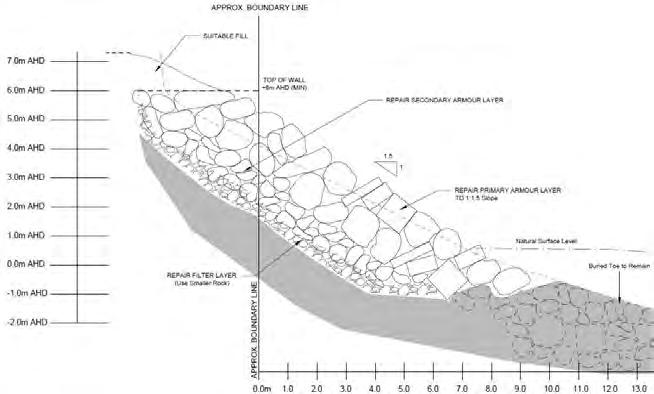
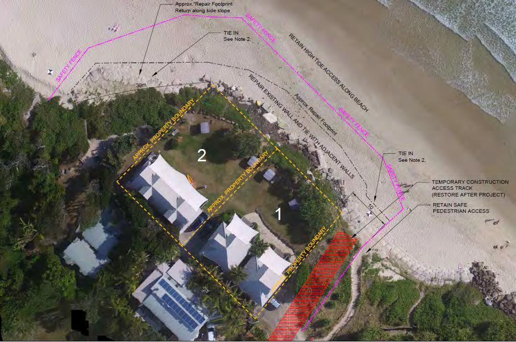
51 51

52 and 48 Childe St It is apparent from photogrammetry profiles undertaken in the vicinity (BMT WBM 2013) that there has been a steady erosion of the beach and dunes from in front of this property. From aerial photos it is apparent that the existing walls project well into the active beach system and have already resulted in the loss of both dunes and beach. This will accelerate into the future if new walls are approved and built, with the beach continuing to disappear and access along the beach increasingly impeded. In response to "Q5. Identification of any third parties required to provide owners consent for works on, or access across their land", it is referred to the previous response where it is stated: Landowners consent and access is to be provided by BSC as the first defendant under Para 2 of the Consent orders: 2 The Court NOTES that should landowners consent and access be required from the First Defendant for works under Paragraph 1(b), that consent and access will not be unreasonably withheld Works specified in 1(b) are for "lawfully approved repair", these works involve building a totally new wall. They do not represent repair works so consent can not be taken for granted. Works at 44 and 48 Childe St are intended to be mostly on the Road Reserve, with a significant extension onto the Crown reserve. A significant part of the development in the road reserve is outside the 10m strip of Council Road Reserve and thus on the Crown Road Reserve. The access is intended to be through Crown Reserve. Owners permission has not been obtained. The design drawings clearly show that the proposal is to remove the existing walls and replace them with a new structure. This will prolong their design life and thus impacts, most significantly by giving the location of walls on this site retrospective approval. 52
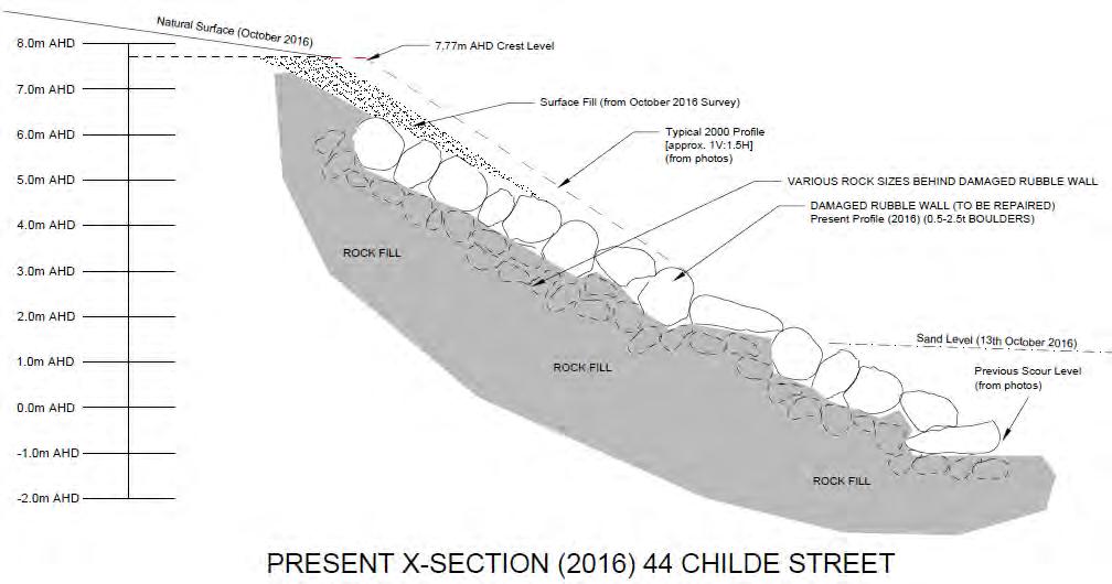
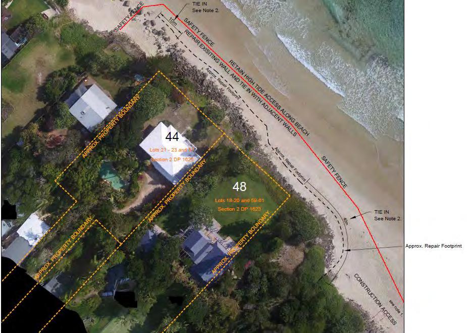
53 53

54 6.3. 6B Childe St It is apparent from photogrammetry profiles undertaken in the vicinity (BMT WBM 2013) that there has been a steady erosion of the beach and dunes from in front of this property, with dune retreat being stopped by the late 1970s, and the beach continuing to retreat until until intermittently disappearing since the late 1990s, pressumably by some obstructions,,since 1999 the existing walls have begun to initiate serious erosion at their end, which indicates that beach erosion had progressed to the extent that erosion due to the seawalls began to be manifest. The major erosion since 2007 indicates that erosion is rapidly escalating. Works at 6B Childe St are to be undertaken on the Crown Road Reserve (and extend in front of both adjoing properies), and access is proposed through the Crown Road Reserve and Council land. No owners permission has been obtained for the Crown lands and as the proposal is to construct new walls Council consent can not be taken for granted. The design drawings clearly show that the proposal is to remove the existing walls and replace them with a new structure. This will prolong their design life and thus impacts, most significantly by giving the location of walls on this site retrospective approval. 54

55 and 28A Childe St It is apparent from photogrammetry profiles undertaken in the vicinity (BMT WBM 2013) that there has been a steady erosion of the beach and dunes from in front of this property, with dune retreat being stopped by the late 1970s, and the beach continuing to retreat until until intermittently disappearing since around If new walls are built soon there will be no beatch left in front of the walls. It is claimed that "The walls have been in place since about It is understood that the walls were constructed by the Byron Erosion Trust", though nothing to substantiate this claim is provided 55

, and the access appears to be")
56 and there is no indication of who the Byron Erosion Trust were or what their authority to approve rock walls was. There is also no indication of how whatever may have been built back then compares to what is there now. In response to Q5. Identification of any third parties required to provide owners consent for works on, or access across their land" it is claimed that: All work will be within The Esplanade owned by Council. This is evidently false as the footprint of the walls extends outside the Council road reserve and into the Crown road reserve in front (with safety fence well beyond), and the access appears to be intended through the Crown Reserve at the old jetty site. No owners permission has been obtained for the Crown lands and as the proposal is to construct new walls Council consent can not be taken for granted. The design drawings clearly show that the proposal is to remove the existing walls and replace them with a new structure. This will prolong their design life and thus impacts, most significantly by giving the location of walls on this site approval. 56
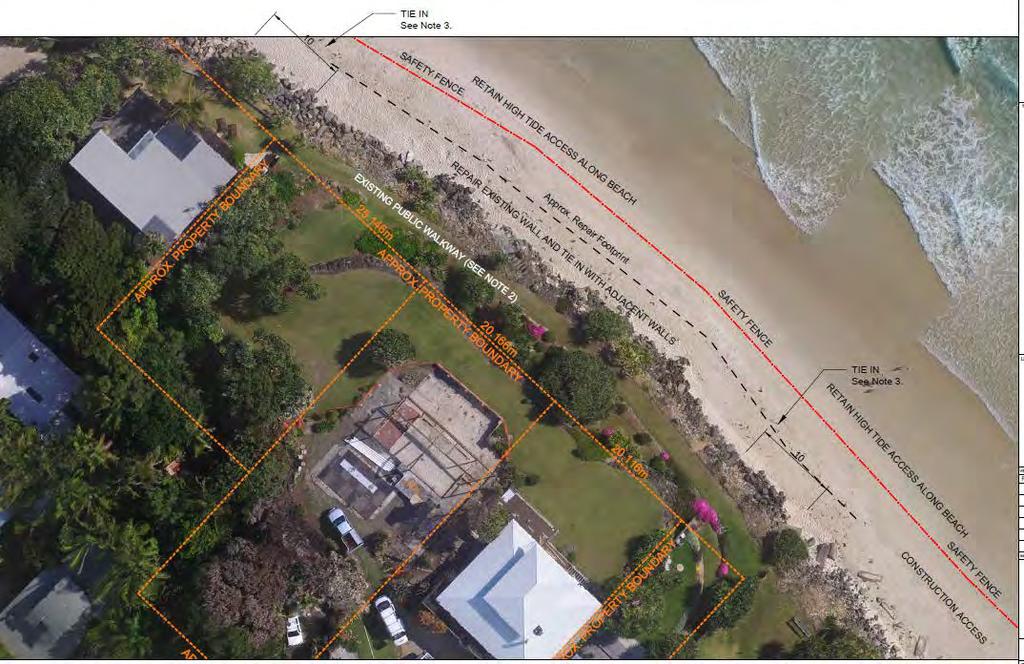
57 57
Draft Coastal Zone Management Plan for Byron Shire Coastline
 Byron Shire Council Draft Coastal Zone Management Plan for Byron Shire Coastline 26 November 2010 #1030842 Presentation Outline o o o o o o o Brief Byron Shire erosion history What is a CZMP? Why Develop
Managing Coastal Hazards Overview
 Managing Coastal Hazards Overview a history of coastal erosion and the Planned Retreat strategy within Byron Shire This presentation explores the history of the Byron Shire coastline with relevance to:
PUBLIC EXHIBITION OF COASTAL ZONE MANAGEMENT PLAN FOR COLLAROY-NARRABEEN BEACH AND FISHERMANS BEACH
 ITEM 8.3 REPORTING MANAGER TRIM FILE REF 2014/110936 ATTACHMENTS PUBLIC EXHIBITION OF COASTAL ZONE MANAGEMENT PLAN FOR COLLAROY-NARRABEEN BEACH AND FISHERMANS BEACH GROUP MANAGER NATURAL ENVIRONMENT 1
Impacts of breakwaters and training walls
 Across the eastern seaboard of Australia, breakwaters and training walls have instigated fundamental perturbations to coastal and estuary processes. This has induced long-term changes to foreshore alignments,
Q1. What are the primary causes/contributors to coastal erosion at Westshore and the concept of longshore / littoral drift.
 Q1. What are the primary causes/contributors to coastal erosion at Westshore and the concept of longshore / littoral drift. In order of (timing related) contribution to present problem 1. Beach is too
SELECTION OF THE PREFERRED MANAGEMENT OPTION FOR STOCKTON BEACH APPLICATION OF 2D COASTAL PROCESSES MODELLING
 SELECTION OF THE PREFERRED MANAGEMENT OPTION FOR STOCKTON BEACH APPLICATION OF 2D COASTAL PROCESSES MODELLING C Allery 1 1 DHI Water and Environment, Sydney, NSW Abstract This paper presents an approach
DUNE STABILIZATION AND BEACH EROSION
 DUNE STABILIZATION AND BEACH EROSION CAPE HATTERAS NATIONAL SEASHORE NORTH CAROLINA ROBERT DOLAN PAUL GODFREY U. S. DEPARTMENT OF INTERIOR NATIONAL PARK SERVICE OFFICE OF NATURAL SCIENCE WASHINGTON, D.
NORTHERN CELL OPTIONS SHORTLIST RECOMMENDATIONS
 OPTIONS SHORTLIST RECOMMENDATIONS Coastal Unit C: Bayview Options recommended for MCDA scoring. Status quo. Planting 3. Renourishment (gravel) 6. Beach-scraping 7. Restore shingle crest. Inundation accommodation
Emergency Coastal Protection Works Practical Lessons For The Future From The Past
 Emergency Coastal Protection Works Practical Lessons For The Future From The Past Angus Jackson1 Principal Engineer, International Coastal Management a.jackson@coastalmanagement www.coastalmanagement.com.au
Long Beach Island Holgate Spit Little Egg Inlet Historical Evolution Introduction Longshore Transport Map, Survey and Photo Historic Sequence
 Appendix B Long Beach Island Holgate Spit Little Egg Inlet Historical Evolution Introduction The undeveloped southern end of Long Beach Island (LBI) is referred to as the Holgate spit as it adjoins the
Australian Coastal Councils Conference
 Australian Coastal Councils Conference Kiama March 2019 Where Has My Beach Gone? (and what can I do about it?) Dr Andrew McCowan Water Technology Where Has My Beach Gone? Where Has My Beach Gone? Where
Beach profile surveys and morphological change, Otago Harbour entrance to Karitane May 2014 to June 2015
 Beach profile surveys and morphological change, Otago Harbour entrance to Karitane May 2014 to June 2015 Prepared for Port Otago Ltd Martin Single September 2015 Shore Processes and Management Ltd Contact
CHAPTER 8 ASSESSMENT OF COASTAL VULNERABILITY INDEX
 124 CHAPTER 8 ASSESSMENT OF COASTAL VULNERABILITY INDEX 8.1 INTRODUCTION In order to assess the vulnerability of the shoreline considered under this study against the changing environmental conditions,
Part 9 Specific Land Uses - Foreshore & Waterway Development
 7 FORESHORE AND WATERWAY DEVELOPMENT This section applies to the following development uses proposed within the foreshore area (defined by LM LEP 2014), and contains Council s specific requirements for
MODELLING THE SHORELINE IMPACTS OF RICHMOND RIVER TRAINING WALLS
 MODELLING THE SHORELINE IMPACTS OF RICHMOND RIVER TRAINING WALLS D Patterson 1 1 BMT WBM / University Of Qld, Brisbane, QLD Introduction The construction of river entrance training walls is generally aimed
Volume and Shoreline Changes along Pinellas County Beaches during Tropical Storm Debby
 Volume and Shoreline Changes along Pinellas County Beaches during Tropical Storm Debby Ping Wang and Tiffany M. Roberts Coastal Research Laboratory University of South Florida July 24, 2012 Introduction
LAB: WHERE S THE BEACH
 Name: LAB: WHERE S THE BEACH Introduction When you build a sandcastle on the beach, you don't expect it to last forever. You spread out your towel to sunbathe, but you know you can't stay in the same spot
To: William Woods, Jenni Austin Job No: CentrePort Harbour Deepening Project - Comments on community queries
 Memo To: William Woods, Jenni Austin From: Richard Reinen-Hamill Date: Subject: cc: 1 Purpose This memo sets out our response to issues raised at and after Seatoun community consultation sessions held
EVALUATION OF BEACH EROSION UP-DRIFT OF TIDAL INLETS IN SOUTHWEST AND CENTRAL FLORIDA, USA. Mohamed A. Dabees 1 and Brett D.
 EVALUATION OF BEACH EROSION UP-DRIFT OF TIDAL INLETS IN SOUTHWEST AND CENTRAL FLORIDA, USA Mohamed A. Dabees 1 and Brett D. Moore 1 The paper discusses the analysis of up-drift beach erosion near selected
Photo by: Darryl Hatheway, 2011
 Photo by: Darryl Hatheway, 2011 September 11, 2015 Presentation Discussion Examine PFD V-Zone Mapping in Wave Runup Dominated West Coast Application of PFD V-Zone Mapping Criteria in Pacific G&S PFD V-Zone
ALTERNATIVES FOR COASTAL STORM DAMAGE MITIGATION
 ALTERNATIVES FOR COASTAL STORM DAMAGE MITIGATION Dave Basco Old Dominion University, Norfolk, Virginia, USA National Park Service Photo STRUCTURAL (changes to natural, physical system) hardening (seawalls,
Inspection of Clarence City Beaches following Winter 2011 Storm Events
 18 July 2011 WRL Ref: WRL10086TDS L20110718 Messrs P Watson & I Preece Clarence City Council PO Box 96 Rosny Park TAS 7018 By email: pwatson@ccc.tas.gov.au ipreece@ccc.tas.gov.au Dear Phil/Ian, Inspection
Inlet Management Study for Pass-A-Grille and Bunces Pass, Pinellas County, Florida
 Inlet Management Study for Pass-A-Grille and Bunces Pass, Pinellas County, Florida Final Report Submitted By Ping Wang, Ph.D., Jun Cheng Ph.D., Zachary Westfall, and Mathieu Vallee Coastal Research Laboratory
HURRICANE SANDY LIMITED REEVALUATION REPORT UNION BEACH, NEW JERSEY DRAFT ENGINEERING APPENDIX SUB APPENDIX D SBEACH MODELING
 HURRICANE SANDY LIMITED REEVALUATION REPORT UNION BEACH, NEW JERSEY DRAFT ENGINEERING APPENDIX SUB APPENDIX D SBEACH MODELING Rev. 18 Feb 2015 1 SBEACH Modeling 1.0 Introduction Following the methodology
The Dynamic Coast. Right Place Resources. A presentation about the interaction between the dynamic coast and people
 The Dynamic Coast Houses threatened by coastal erosion in California Right Place Resources A presentation about the interaction between the dynamic coast and people For the rest of the presentations in
Montserrat. Wise practices for coping with. i b bea n Se a
 Wise practices for coping with Montserrat Car i b bea n Se a Fisheries Division, Montserrat Physical Planning Department, Montserrat University of Puerto Rico, Sea Grant College Program Caribbean Development
Shoreline Response to an Offshore Wave Screen, Blairgowrie Safe Boat Harbour, Victoria, Australia
 Shoreline Response to an Offshore Wave Screen, Blairgowrie Safe Boat Harbour, Victoria, Australia T.R. Atkins and R. Mocke Maritime Group, Sinclair Knight Merz, P.O. Box H615, Perth 6001, Australia ABSTRACT
Implications of proposed Whanganui Port and lower Whanganui River dredging
 PO Box 637 Wanganui 4540 Attention: Rowan McGregor Dear Rowan 1 Summary We understand that it has been proposed to bring large vessels into the Port at Whanganui requiring the excavation of a channel up
Beach, dune and development in the Borough of Mantoloking as of January Prepared for The Borough of Mantoloking: April 2, 2008
 Summary of 20-years of Shoreline Monitoring Between Maryland Avenue, Point Pleasant Beach, Bay Head, Mantoloking, Brick Township, to 1 st Avenue in Normandy Beach, Ocean County, New Jersey & an Evaluation
Today: Coastal Issues and Estuaries
 Today: Coastal Issues and Estuaries Coastal issues Human effect on coastlines What is an estuary Why are they so important? Circulation of water in estuary Environmental issues Coastal Issues: Problem
Delaware Chapter Surfrider Foundation - Indian River Inlet Monitoring
 Delaware Chapter Surfrider Foundation - Indian River Inlet Monitoring In 2012, the Delaware Surfrider Foundation Chapter formed the Surf Quality and Access Committee to focus on issues such as surf spot
ATLANTIC COUNTY 2006 to 2008
 ATLANTIC COUNTY 2006 to 2008 The Atlantic County oceanfront shoreline consists of three barrier islands where the northern one, Little Beach Island and a third of the second, Brigantine Island, are undeveloped
UPPER BEACH REPLENISHMENT PROJECT RELATED
 ASSESSMENT OF SAND VOLUME LOSS at the TOWNSHIP of UPPER BEACH REPLENISHMENT PROJECT RELATED to the LANDFALL OF HURRICANE SANDY - PURSUANT TO NJ-DR 4086 This assessment is in response to Hurricane Sandy
Environmental Protection on the Gold Coast of Queensland, Australia. 1. What is the appeal of the Gold Coast to tourists?
 Environmental Protection on the Gold Coast of Queensland, Australia Sections 1. What is the appeal of the Gold Coast to tourists? 2. How are Gold Coast visitor trends changing? 3. How can the impacts of
ALTERNATIVES FOR COASTAL STORM DAMAGE MITIGATION AND FUNCTIONAL DESIGN OF COASTAL STRUCTURES
 The University of the West Indies Organization of American States PROFESSIONAL DEVELOPMENT PROGRAMME: COASTAL INFRASTRUCTURE DESIGN, CONSTRUCTION AND MAINTENANCE A COURSE IN COASTAL DEFENSE SYSTEMS I CHAPTER
Wave-dominated embayed beaches. Andrew D Short School of Geosciences University of Sydney
 Wave-dominated embayed beaches Andrew D Short School of Geosciences University of Sydney Wave-dominated embayed beaches wave-dominated beaches embayed beaches morphodynamics of W-D embayed beaches circulation,
INFORMATION SHEET NOOSA MAIN BEACH ARTIFICIAL REEF PROPOSAL
 INFORMATION SHEET NOOSA MAIN BEACH ARTIFICIAL REEF PROPOSAL 1. BACKGROUND Background information on the history of erosion at Noosa Main Beach is well documented in the technical paper prepared by P. Coughlin,
Implications of changes to El Niño Southern Oscillation for coastal vulnerability in NSW
 Implications of changes to El Niño Southern Oscillation for coastal vulnerability in NSW By Thomas Mortlock (Thomas.mortlock@mq.edu.au) El Niño Southern Oscillation (ENSO) has a strong impact on weather
Shorelines Earth - Chapter 20 Stan Hatfield Southwestern Illinois College
 Shorelines Earth - Chapter 20 Stan Hatfield Southwestern Illinois College The Shoreline A Dynamic Interface The shoreline is a dynamic interface (common boundary) among air, land, and the ocean. The shoreline
Chapter 10 Lecture Outline. The Restless Oceans
 Chapter 10 Lecture Outline The Restless Oceans Focus Question 10.1 How does the Coriolis effect influence ocean currents? The Ocean s Surface Circulation Ocean currents Masses of water that flow from one
Lecture Outlines PowerPoint. Chapter 15 Earth Science, 12e Tarbuck/Lutgens
 Lecture Outlines PowerPoint Chapter 15 Earth Science, 12e Tarbuck/Lutgens 2009 Pearson Prentice Hall This work is protected by United States copyright laws and is provided solely for the use of instructors
SACO RIVER AND CAMP ELLIS BEACH SACO, MAINE SECTION 111 SHORE DAMAGE MITIGATION PROJECT APPENDIX F ECONOMIC ASSESSMENT
 SACO RIVER AND CAMP ELLIS BEACH SACO, MAINE SECTION 111 SHORE DAMAGE MITIGATION PROJECT APPENDIX F ECONOMIC ASSESSMENT Department of the Army New England District, Corps of Engineers 696 Virginia Road
EXISTING AND PLANNED STRATEGIES AND ACTIONS CONNECTED WITH COASTAL PROTECTION IN ASPECT OF PREDICTED SEA LEVEL RISE
 EXISTING AND PLANNED STRATEGIES AND ACTIONS CONNECTED WITH COASTAL PROTECTION IN ASPECT OF PREDICTED SEA LEVEL RISE Andrzej Cieślak Long term coastal protection strategy In 2000 a new 1 Polish long term
Town of Duck, North Carolina
 Tracking No. 00.00.2010 Erosion Mitigation And Shoreline Management Feasibility Study Town of Duck, North Carolina Coastal Planning & Engineering of North Carolina August 15, 2012 Tom Jarrett Robert Neal
23- Year Sand Volume Changes at Site 132, 15th Street, Brigantine
 149 Figure75. Location map for the 9 NJBPN profile sites in Atlantic County, NJ ATLANTIC COUNTY SPRING 2008 to FALL 2009 150 The Atlantic County oceanfront shoreline consists of three barrier islands.
USE OF SEGMENTED OFFSHORE BREAKWATERS FOR BEACH EROSION CONTROL
 .. CETN-III-22 4/84 PURPOSE: USE OF SEGMENTED OFFSHORE BREAKWATERS FOR BEACH EROSION CONTROL To provide information on the functional application of and general design considerations for using offshore
CLAM PASS RESTORATION AND MANAGEMENT PLAN BATHYMETRIC MONITORING REPORT NO. 7 Including Interior Bay Dredge Cuts and Tidal Data
 CLAM PASS RESTORATION AND MANAGEMENT PLAN BATHYMETRIC MONITORING REPORT NO. 7 Including Interior Bay Dredge Cuts and Tidal Data Submitted to: Florida Department of Environmental Protection DEP File No.
Coastal Change and Conflict
 Coastal Change and Conflict Outline of the Topic Contrasting Coasts why do all coasts not look the same? Geology of the coast the impact rock structure has on the coastline Waves Constructive and destructive
Chiswell and Chesil Beach (to Wyke Narrows) 6a02 and 6a03 SUMMARY OF PREFERRED PLAN RECOMMENDATIONS AND JUSTIFICATION
 6a02 and 6a03 SUMMARY OF PREFERRED PLAN RECOMMENDATIONS AND JUSTIFICATION") Location reference: Policy Unit reference: Plan: Chiswell and Chesil Beach (to Wyke Narrows) 6a02 and 6a03 SUMMARY OF PREFERRED PLAN RECOMMENDATIONS AND JUSTIFICATION The long term aim for this section
Location reference: Policy Unit reference: Plan: Chiswell and Chesil Beach (to Wyke Narrows) 6a02 and 6a03 SUMMARY OF PREFERRED PLAN RECOMMENDATIONS AND JUSTIFICATION The long term aim for this section
Chapter. The Dynamic Ocean
 Chapter The Dynamic Ocean An ocean current is the mass of ocean water that flows from one place to another. 16.1 The Composition of Seawater Surface Circulation Surface Currents Surface currents are movements
New Jersey Coastal Zone Overview. The New Jersey Beach Profile Network (NJBPN) 3 Dimensional Assessments. Quantifying Shoreline Migration
 3 Dimensional Assessments. Quantifying Shoreline Migration") New Jersey Coastal Zone Overview The New Jersey Beach Profile Network (NJBPN) Objectives Profile Locations Data Collection Analyzing NJBPN Data Examples 3 Dimensional Assessments Methodology Examples Quantifying
New Jersey Coastal Zone Overview The New Jersey Beach Profile Network (NJBPN) Objectives Profile Locations Data Collection Analyzing NJBPN Data Examples 3 Dimensional Assessments Methodology Examples Quantifying
Controlling Coastal erosion
 Controlling Coastal erosion Coastal Erosion Rates in the U.S. Coastal Erosion and Stabilization Economic pressures demanding the stabilization of beaches and coastlines are immense Coastal Erosion and
Inventory of coastal sandy areas protection of infrastructure and planned retreat
 2018-02-28 Inventory of coastal sandy areas protection of infrastructure and planned retreat Johanna Birgander, Thorbjörn Nilsson, Pär Persson Summary To estimate the natural protection around the coast
Fact Sheet Ordinance Regulating Erosion Threatened Structures
 Fact Sheet Ordinance Regulating Erosion Threatened Structures Town of Duck, North Carolina August 15, 2011 What is being considered? The Town of Duck Council is considering an ordinance to limit the encroachment
Table 4. Volumetric Change Rates Pre-Project and Post-Project for the Town of Duck
 V. VOLUMETRIC CHANGES General Volumetric changes measured over the entire monitoring area for various time periods are provided in Table 4. The volume changes are given in terms of cubic yards/foot of
SPECIAL SPRING 2018 STORM REPORT ON THE CONDITION OF THE MUNICIPAL BEACHES FOR THE BOROUGH OF STONE HARBOR, CAPE MAY COUNTY, NEW JERSEY
 SPECIAL SPRING 2018 STORM REPORT ON THE CONDITION OF THE MUNICIPAL BEACHES FOR THE BOROUGH OF STONE HARBOR, CAPE MAY COUNTY, NEW JERSEY Aerial photograph taken April 21, 2018 showing the view up the beach
Overview. Beach Features. Coastal Regions. Other Beach Profile Features. CHAPTER 10 The Coast: Beaches and Shoreline Processes.
 Overview CHAPTER 10 The Coast: Beaches and Shoreline Processes Coastal regions constantly change. The beach is a dominant coastal feature. Wave activity continually modifies the beach and coastal areas.
Reading Material. Inshore oceanography, Anikouchine and Sternberg The World Ocean, Prentice-Hall
 Reading Material Inshore oceanography, Anikouchine and Sternberg The World Ocean, Prentice-Hall BEACH PROCESSES AND COASTAL ENVIRONMENTS COASTAL FEATURES Cross section Map view Terminology for Coastal
Climate briefing. Wellington region, February Alex Pezza and Mike Thompson Environmental Science Department
 Climate briefing Wellington region, February 2016 Alex Pezza and Mike Thompson Environmental Science Department For more information, contact the Greater Wellington Regional Council: Wellington PO Box
Impact of Hurricane Matthew on the Atlantic Coast of Florida
 Impact of Hurricane Matthew on the Atlantic Coast of Florida A coastal engineer was driving across country and his jeep broke down in front of a monastery. It was late in the day and the monks invited
Figure79. Location map for the 10 NJBPN profile sites in Atlantic County, NJ 155
 154 Figure79. Location map for the 10 NJBPN profile sites in Atlantic County, NJ 155 ATLANTIC COUNTY SPRING 2009 to FALL 2010 The Atlantic County coastline consists of three barrier islands. Between Little
St Kitts. Wise practices for coping with
 Wise practices for coping with St Kitts Caribbean Sea Department of the Environment, St Kitts Fisheries Division, St Kitts Physical Planning and Development Division, St Kitts University of Puerto Rico,
Julebæk Strand. Effect full beach nourishment
 Julebæk Strand Effect full beach nourishment Aim of Study This study is a part of the COADAPT funding and the aim of the study is to analyze the effect of beach nourishment. In order to investigate the
4/20/17. #32 - Coastal Erosion Case Histories - Lake Michigan
 Writing Assignment Due Monday by 11:59 pm #32 - Coastal Erosion Case Histories - Lake Michigan See main class web pages for detailed instructions Submit papers Illinois Compass No copying: Compass will
Case study 64. Shoreham Harbour Shingle Bypassing and Recycling
 Case study 64. Shoreham Harbour Shingle Bypassing and Recycling Authors: Tony Parker, Uwe Dornbusch Main driver: Improved defences Project stage: Ongoing construction/operation since 1992 Photo 1: Shoreham
North Shore of Long Island, Feasibility Study
 North Shore of Long Island, Asharoken New York Asharoken, Feasibility Study Asharoken, NY Public Meeting June 30, 2015 US Army Corps of Engineers US Army Corps of Engineers New York BUILDING STRONG BUILDING
HARBOUR SEDIMENTATION - COMPARISON WITH MODEL
 HARBOUR SEDIMENTATION - COMPARISON WITH MODEL ABSTRACT A mobile-bed model study of Pointe Sapin Harbour, in the Gulf of St. Lawrence, resulted in construction of a detached breakwater and sand trap to
NSW STATE STORM EMERGENCY SUB PLAN EMERGENCY PLANNING IN THE COASTAL ZONE
 NSW STATE STORM EMERGENCY SUB PLAN EMERGENCY PLANNING IN THE COASTAL ZONE November 2013 Cherie Parmenter 1, Nicholas Kuster 1, Belinda Davies 1 Phil Watson 2 1 NSW State Emergency Service (NSW SES) 2 NSW
BYPASS HARBOURS AT LITTORAL TRANSPORT COASTS
 BYPASS HARBOURS AT LITTORAL TRANSPORT COASTS by K. Mangor 1, I. Brøker 2, R. Deigaard 3 and N. Grunnet 4 ABSTRACT Maintaining sufficient navigation depth in front of the entrance at harbours on littoral
Nevis. Wise practices for coping with
 Wise practices for coping with Nevis Caribbean Sea Nevis Historical and Conservation Society Department of Physical Planning, Natural Resources and Environment, Fisheries Division University of Puerto
Figure 4, Photo mosaic taken on February 14 about an hour before sunset near low tide.
 The Impact on Great South Bay of the Breach at Old Inlet Charles N. Flagg and Roger Flood School of Marine and Atmospheric Sciences, Stony Brook University Since the last report was issued on January 31
Geology of the Hawaiian Islands
 Geology of the Hawaiian Islands Class 24 8 April 2004 Any Questions? Rise and fall of sea level and its effect on Hawai`i Sea level Has fluctuated up and down many times in the geologic past Evidence?
OECS Regional Engineering Workshop September 29 October 3, 2014
 B E A C H E S. M A R I N A S. D E S I G N. C O N S T R U C T I O N. OECS Regional Engineering Workshop September 29 October 3, 2014 Coastal Erosion and Sea Defense: Introduction to Coastal Dynamics David
STORM RESPONSE SIMULATION
 APPENDIX V STORM RESPONSE SIMULATION Final Environmental Impact Statement Village of Bald Head Island Shoreline Protection Project Brunswick County, North Carolina Delft3D Storm Response Simulations With
Chapter 12: Coasts (after a brief review of Tides)
") Chapter 12: Coasts (after a brief review of Tides) 1 Questions from previous classes: What happens when a wave meets a current? wave = people walking current = bus If wave goes with the current, the wave
Chapter 12: Coasts (after a brief review of Tides) 1 Questions from previous classes: What happens when a wave meets a current? wave = people walking current = bus If wave goes with the current, the wave
A REVIEW OF THE CONDITION OF THE MUNICIPAL BEACHES AS A RESULT OF HURRICANE SANDY IN THE BOROUGH OF STONE HARBOR, CAPE MAY COUNTY, NEW JERSEY
 A REVIEW OF THE CONDITION OF THE MUNICIPAL BEACHES AS A RESULT OF HURRICANE SANDY IN THE BOROUGH OF STONE HARBOR, CAPE MAY COUNTY, NEW JERSEY View along the dune scarp from 103 rd Street on October 31,
Absecon Island Shore Protection The planning behind the project
 Absecon Island Shore Protection The planning behind the project Most residents of Atlantic City, Ventnor, Margate and Longport are now aware of upcoming plans to protect their common coastline with a beachfill
Oceans and Coasts. Chapter 18
 Oceans and Coasts Chapter 18 Exploring the oceans The ocean floor Sediments thicken and the age of the seafloor increases from ridge to shore The continental shelf off the northeast United States Constituent
April 7, Prepared for: The Caribbean Disaster Emergency Response Agency Prepared by: CEAC Solutions Co. Ltd.
 April 7, 2006 Prepared for: The Caribbean Disaster Emergency Response Agency Prepared by: Introduction CEAC Solutions Co. Ltd was commissioned in May 2005 to prepare coastal beach erosion hazard maps for
BALD HEAD ISLAND, NC SAND SHARING SYSTEM OVERVIEW AND ASSESSMENT. Erik J. Olsen, P.E. olsen associates, inc.
 BALD HEAD ISLAND, NC SAND SHARING SYSTEM OVERVIEW AND ASSESSMENT Erik J. Olsen, P.E. Olsen Associates, Inc. BACKGROUND Both the Village of Bald Head Island (VBHI) and the Bald Head Island Limited, LLC.
VLH Ltd, Nereide Ltd, Saltlake Resorts Ltd Proposed Beach Erosion Protection Works at Bel Ombre Environmental Impact Assessment
 VLH Ltd, Nereide Ltd, Saltlake Resorts Ltd Proposed Beach Erosion Protection Works at Bel Ombre TATO/EIA/01 Issue 15 February 2017 This report takes into account the particular instructions and requirements
# Post Consultation and Submissions Resource Consent Conditions for Surfing Impact Mitigation August 2016
 # Post Consultation and Submissions Resource Consent Conditions for Surfing Impact Mitigation August 2016 Surf Mitigation Management Plan 1 1 Not less than 6 months prior to the commencement of the construction
COASTAL MANAGEMENT AND PROTECTION METHODS! 1
 COASTAL MANAGEMENT AND PROTECTION METHODS! 1 Strategy What it does Cons Pros Examples SOFT ENGINEERING: The use of ecological principles and practices to reduce erosion and achieve the stabilization and
COUPLED MANAGEMENT STRATEGY LAKE CATHIE ESTUARY & COAST
 Lake Cathie Progress Association Inc. ABN 28 251 433 854 P.O. Box 247 Lake Cathie NSW 2445 PHONE/FAX: 02 6584 8211 EMAIL: r3packag@bigpond.com 20 th October 2009 Port Macquarie Hastings Council PO Box
FINAL REPORT FOR 2013 ON THE CONDITION OF THE MUNICIPAL OCEANFRONT BEACHES THE BOROUGH OF AVALON, CAPE MAY COUNTY, NEW JERSEY
 FINAL REPORT FOR 2013 ON THE CONDITION OF THE MUNICIPAL OCEANFRONT BEACHES THE BOROUGH OF AVALON, CAPE MAY COUNTY, NEW JERSEY View from 12 th Street to the south taken February 28, 2013, following completion
The Sand Beaches of New Hampshire and Maine
 The Sand Beaches of New Hampshire and Maine Beach Preservation and Erosion Control Photographs provided by Joe Kelly and Steve Adams Cover photo: Reid State Park, ME Introduction The sand beaches of New
Building Coastal Resiliency at Plymouth Long Beach
 Building Coastal Resiliency at Plymouth Long Beach Department of Marine and Environmental Affairs March 30, 2017 Introducing Green Infrastructure for Coastal Resiliency Plymouth Long Beach & Warren s Cove
Coastal management has lagged behind the growth in population leading to problems with pollution
 Fifty percent of the population of the industrialized world lives within 100 km of a coast. Coastal management has lagged behind the growth in population leading to problems with pollution and natural
Marginal Marine Environments
 Marginal Marine Environments Delta: discrete shoreline protuberances formed where rivers enter oceans, semi-enclosed seas, lakes or lagoons and supply sediment more rapidly than it can be redistributed
RAINBOW BAY FIELD REPORT
 RAINBOW BAY FIELD REPORT Contents Page Abstract 1.0 Introduction.. 2.0 Methodology 2.1 Limitations.. 3.0 Statement of Findings. 3.1 History. 3.2 Data Collection. 3.2.1 Observations. 3.2.2 Management Strategies
A part of BMT in Energy and Environment Woorim Beach Shoreline Erosion Management Plan
 A part of BMT in Energy and Environment Woorim Beach Shoreline Erosion Management Plan R.B16200.001.03.doc September 2007 Woorim Beach Shoreline Erosion Management Plan Prepared For: Prepared By: Caboolture
Greater Taree Coastal Zone Management Plan
 Greater Taree Coastal Zone Management Plan June 2015 Adopted by Council at the 17 June 2015 Ordinary Meeting Photograph of dune restoration at Old Bar undertaken in 2014 Contents 1. Executive summary...
The evolution of beachrock morphology and its influence on beach morphodynamics
 The evolution of beachrock morphology and its influence on beach morphodynamics Robert J. Turner Division of Natural Sciences, Southampton College, 239 Montauk Highway, Southampton, NY 11968, U.S.A. email:
Performance of Upham Beach T-Groin Project and Its Impact to the Downdrift Beach
 Performance of Upham Beach T-Groin Project and Its Impact to the Downdrift Beach Progress Report for the Period of October 2008 to April 2009 Submitted by Ping Wang, Ph.D., and Tiffany M. Roberts Department
In order to better manage coastline hazards, it is necessary to first understand the various processes that cause them. The waves, water levels and
 In 2015 Council worked with coastal engineering consultants to complete a detailed analysis of coastal processes and the risks from coastal hazards along the coastal zone of the Shire. This study looked
IMPACTS OF COASTAL PROTECTION STRATEGIES ON THE COASTS OF CRETE: NUMERICAL EXPERIMENTS
 IMPACTS OF COASTAL PROTECTION STRATEGIES ON THE COASTS OF CRETE: NUMERICAL EXPERIMENTS Tsanis, I.K., Saied, U.M., Valavanis V. Department of Environmental Engineering, Technical University of Crete, Chania,
AN OVERVIEW OF RECENT PROJECTS RELATED TO SAND BUDGETS, SOUTHERN CALIFORNIA BEACHES
 AN OVERVIEW OF RECENT PROJECTS RELATED TO SAND BUDGETS, SAND SUPPLY, COASTAL ARMORING, MANAGEMENT, AND VALUING SOUTHERN CALIFORNIA BEACHES Dr. Kiki Patsch California State University Channel Islands Environmental
INFLUENCE OF DAMAGED GROINS ON NOURISHED SEASHORE
 INFLUENCE OF DAMAGED GROINS ON NOURISHED SEASHORE Ostrowski R 1., Pruszak Z. 1, Schönhofer J. 1, Szmytkiewicz M. 1, Szmytkiewicz P. 1 The system of timber palisade groins can be very helpful as a measure
Earth Science Chapter 16 Section 3 Review
 Name: Class: Date: Earth Science Chapter 16 Section 3 Review Multiple Choice Identify the choice that best completes the statement or answers the question. 1. The movement of water that parallels the shore
NCCOE EA Coastal Adaptation Guidelines. Section I Emerging Technology Novel Alternative Approaches to Coastal Erosion
 NCCOE EA Coastal Adaptation Guidelines Section I Emerging Technology Novel Alternative Approaches to Coastal Erosion Alessio Mariani, Doug Lord, Tony Webb James Carley, Matt Blacka, Brett Miller Ian Turner,